Mineralogical Properties of Cracking Clay Soils along ... Doka M. Ali, et al.pdf · plain to...
17
Int.J.Curr.Microbiol.App.Sci (2016) 5(10): 1049-1065 1049 Original Research Article http://dx.doi.org/10.20546/ijcmas.2016.510.111 Mineralogical Properties of Cracking Clay Soils along Toposequence at Middle and Lower Clay Plains of Eastern Nuba Mountains South Kordofan, Sudan El-Abbas Doka M. Ali 1 , Omima Omer A. Showgi 2 , El Tag Fadlalla A. Rahim 3 and Mahgoub Suliman Mohamedain 4* 1 Land Evaluation and Remote Sensing, College of Agricultural Studies, Sudan University of Science and Technology, Shambat 2 Properties and Genesis of Soils, College of Science and Technology, Department of Botany, Shendi University, Nile State, Showgi 3 Soil Pedology, Department of Soil Science and Environmental, Faculty of Agriculture, University of Khartoum, Shambat - Khartoum North, Sudan 4 Remote Sensing for Forest Management, College of Forestry and Range Science, Sudan University of Science and Technology *Corresponding author ABSTRACT This research study was carried to identify the mineralogical properties of the cracking clay soils (Vertisols) at the upper clay plains located at the eastern parts of Nuba Mountains, Sudan. Soil samples were collected from profile pits along a toposequence in a transect stretching from Abbasyia to Megenis through Terter (64 Km).Another lowest site was selecte on the White Nile terrace adjacent to lower clay plain to investigate its clay mineralogy in relation to Nuba Mountains clays. The area is an intermountain, slightly undulating clay plain surrounded by the Nuba mountains and hills. The majority of the soils identified belong to the dark cracking clays (Ahmed, N. 1996). The huge mantle of clay rests on the basement complex but the origin of this clay is somewhat controversial, it is either transported from another place and deposited were it is or formed in situ (Vail, J.R. 1971). According to (Balwant, S. and H. Susan. 2002), clay minerals particularly smectite are sensitive to pressure and temperature conditions and to variations in the chemical environment (sensitivity is expressed as crystallographic and mineralogical changes). Consequently, the study of clays can supply a great deal of information concerning the processes that occur in the evolution of the sequences of which they form a part such as weathering, hydrothermal alteration, digenesis, low grade metamorphism, etc. Furthermore, clay may reflect the history of the sediments better than any other component, because the characteristics of the clay minerals are to some extent subject to changes depending on the environment in which they are found (Grim 1968). The x- ray diffraction (XRD) analyses were used to identify quantitatively and semi-quantitatively the proportion of each clay mineral with respect to other clay minerals present in the tested samples. The X – Ray diffraction analyses of samples in these profiles indicates that the dominant clay minerals is Smectite with percentages ranging between 71.3 - 36.1% followed by kaolinite 46.5 - 22.2%, chlorite 6.8 - 1.2%, illite 15.32 -2.6% and Semctite\ Chlorite 6.9 - 1.0%. The bulk mineral analysis indicate the present quartz minerals found in all sites with percentages 69.2, 12.5, 35.1, 86.8, 31.7, 31.6, 50.1, 50.6; mica is found only in profiles except siteTE008with percentages of 16.9 and traces at TE005;Kaolinite present in sitesTE009, Te008, TE006, TE004 and ME003 with percentage of 8.9, 1.9, 2.1, traces, 0.6, 0.4; Vermiculite is found only in site TE009 with percentages of 5.6 and non-silicate minerals Magnetite exists in sites TE009, TE008, TE007 with percentages of 2.5, traces and 11.7 and Clinochlopreexist in TE007 and TE005 with percentages of 28.4 and 40.7. In aggregates this mineralogical assemblages occurring in three areas (Abbasyia,Megenis and Terter) suggest origins of parent materials derived from basic igneous\metamorphic rocks that have under gone weathering and in situ formation of clay minerals that have imposed magnitude of variations in the Pedological features. Keywords Nuba Mountains, Middle and Lower Clay Plains, Clay Mineralogy. Accepted: 28 August 2016 Available Online: 10 October 2016 Article Info International Journal of Current Microbiology and Applied Sciences ISSN: 2319-7706 Volume 5 Number 10 (2016) pp. 1049-1065 Journal homepage: http://www.ijcmas.com
Transcript of Mineralogical Properties of Cracking Clay Soils along ... Doka M. Ali, et al.pdf · plain to...
Int.J.Curr.Microbiol.App.Sci (2016) 5(10): 1049-1065
1049
Original Research Article http://dx.doi.org/10.20546/ijcmas.2016.510.111
Mineralogical Properties of Cracking Clay Soils along Toposequence
at Middle and Lower Clay Plains of Eastern Nuba Mountains
South Kordofan, Sudan
El-Abbas Doka M. Ali1, Omima Omer A. Showgi
2,
El Tag Fadlalla A. Rahim3 and Mahgoub Suliman Mohamedain
4*
1Land Evaluation and Remote Sensing, College of Agricultural Studies, Sudan University of
Science and Technology, Shambat 2Properties and Genesis of Soils, College of Science and Technology, Department of Botany,
Shendi University, Nile State, Showgi 3Soil Pedology, Department of Soil Science and Environmental, Faculty of Agriculture,
University of Khartoum, Shambat - Khartoum North, Sudan 4Remote Sensing for Forest Management, College of Forestry and Range Science, Sudan
University of Science and Technology
*Corresponding author
A B S T R A C T
This research study was carried to identify the mineralogical properties of the cracking clay soils
(Vertisols) at the upper clay plains located at the eastern parts of Nuba Mountains, Sudan. Soil samples
were collected from profile pits along a toposequence in a transect stretching from Abbasyia to Megenis
through Terter (64 Km).Another lowest site was selecte on the White Nile terrace adjacent to lower clay
plain to investigate its clay mineralogy in relation to Nuba Mountains clays. The area is an intermountain,
slightly undulating clay plain surrounded by the Nuba mountains and hills. The majority of the soils
identified belong to the dark cracking clays (Ahmed, N. 1996). The huge mantle of clay rests on the
basement complex but the origin of this clay is somewhat controversial, it is either transported from another
place and deposited were it is or formed in situ (Vail, J.R. 1971). According to (Balwant, S. and H. Susan.
2002), clay minerals particularly smectite are sensitive to pressure and temperature conditions and to
variations in the chemical environment (sensitivity is expressed as crystallographic and mineralogical
changes). Consequently, the study of clays can supply a great deal of information concerning the processes
that occur in the evolution of the sequences of which they form a part such as weathering, hydrothermal
alteration, digenesis, low grade metamorphism, etc. Furthermore, clay may reflect the history of the
sediments better than any other component, because the characteristics of the clay minerals are to some
extent subject to changes depending on the environment in which they are found (Grim 1968). The x- ray
diffraction (XRD) analyses were used to identify quantitatively and semi-quantitatively the proportion of
each clay mineral with respect to other clay minerals present in the tested samples. The X – Ray diffraction
analyses of samples in these profiles indicates that the dominant clay minerals is Smectite with percentages
ranging between 71.3 - 36.1% followed by kaolinite 46.5 - 22.2%, chlorite 6.8 - 1.2%, illite 15.32 -2.6%
and Semctite\ Chlorite 6.9 - 1.0%. The bulk mineral analysis indicate the present quartz minerals found in
all sites with percentages 69.2, 12.5, 35.1, 86.8, 31.7, 31.6, 50.1, 50.6; mica is found only in profiles except
siteTE008with percentages of 16.9 and traces at TE005;Kaolinite present in sitesTE009, Te008, TE006,
TE004 and ME003 with percentage of 8.9, 1.9, 2.1, traces, 0.6, 0.4; Vermiculite is found only in site TE009
with percentages of 5.6 and non-silicate minerals Magnetite exists in sites TE009, TE008, TE007 with
percentages of 2.5, traces and 11.7 and Clinochlopreexist in TE007 and TE005 with percentages of 28.4
and 40.7. In aggregates this mineralogical assemblages occurring in three areas (Abbasyia,Megenis and
Terter) suggest origins of parent materials derived from basic igneous\metamorphic rocks that have under
gone weathering and in situ formation of clay minerals that have imposed magnitude of variations in the
Pedological features.
K e y w o r d s
Nuba Mountains,
Middle and
Lower Clay
Plains,
Clay Mineralogy.
Accepted:
28 August 2016
Available Online:
10 October 2016
Article Info
International Journal of Current Microbiology and Applied Sciences ISSN: 2319-7706 Volume 5 Number 10 (2016) pp. 1049-1065
Journal homepage: http://www.ijcmas.com
Int.J.Curr.Microbiol.App.Sci (2016) 5(10): 1049-1065
1050
Introduction
In the Sudan, Vertisols occur on large tract
of land, totaling perhaps 50 million ha in
area, is divided naturally into four separated
areas: the central clay plain (Gezira), the
eastern clay plain (El Gadarif), the Nuba
Mountains region and the southern clay
plain (Abyei-Bahr Al Arab). Vertisol in the
Nuba Mountains region occur on gently
undulating plains and have better surface
drained than those in extremely flat
landscape of the other three clay plains.
Dark cracking clay soils “Vertisols” cover
not only large areas of the low lying plains
but also they occur on undulating higher
plains and in many intermountain valleys
throughout the Nuba Mountains area. Some
of these clays, notably those in eastern and
southern lower clay plains, Khor Abu Habil,
Wadi Al Ghalla and the clays of Bahr el
Arab valley, can only be alluvial. But some
other clay, for instance, on undulating high
plains in the Nuba Mountains uplands area
indicate a non-alluvial origin.
The Nuba Mountains Vertisols are
considered to be derived from the
underlying bedrock. Therefore, it is
expected that the parent materials at upper
clay plains have undergone through a shorter
pedogenetic processes compared to those on
low alluvial plains. These non-alluvial clays
are thought to be moved slowly down slope
by combined process of wash and mass
movement. Bases are thought to be washed
from higher areas to accumulate on the
plains where they help in the formation of
the higher base status clays. These soils are
plastic, sticky and have moderately high to
high cation exchange capacities and a high
capacity to shrink and swell with changes in
moisture. Because the lower horizons are
subject to pressure when the soils swell, they
are compact and very slowly permeable to
water. They are usually neutral to slightly in
reaction (Pacheco and Dawoud, 1976).
This research study attempts to identify the
mineralogical properties of the Vertisols at
Middle and Lower clay plains at Nuba
Mountains which gives information about
soil forming processes, alterations, and
development of the soil. Many research
studies were carried to characterize the clay
minerals of Vertisols at different parts the
alluvial lowland clay plains of Sudan which
are mainly used for irrigated farming. The
rainfed lands found less detailed research
attention and particularly the upper, middle
and lower clay plains at Nuba Mountains
region which need more understanding of
their formation and behavior as related to
their use and management. Since the
Vertisols in Nuba Mountains region occur in
topographic sequence of plains (upper,
middle and lower plains); then the
mineralogical characterization provided by
this study will lay the bases for the
subsequent research efforts to study these
soils.
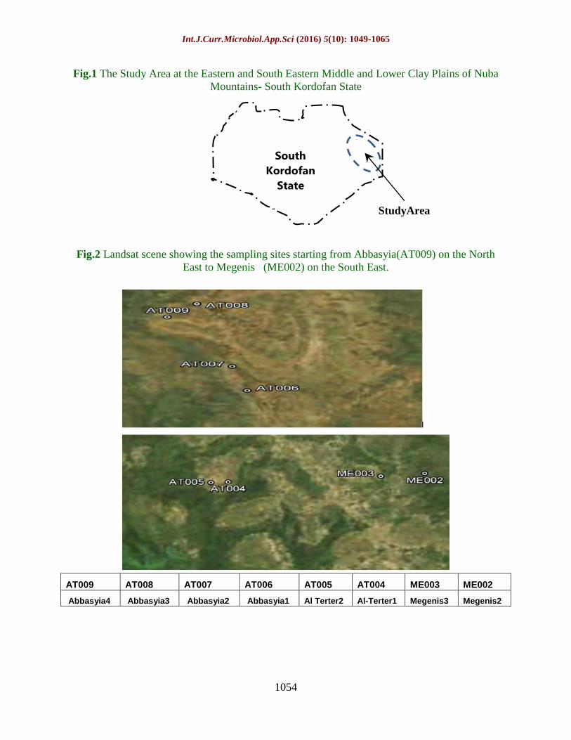
The Study Area
The study area is located in the eastern part
of the Nuba Mountains in South Kordofan
State. The sampling transect (65 Km), starts
from Al Abbasyia town (height 561 m ASL)
in the northeast and ending towards
southeast at Megenis (height 406m ASL),
Figure1 and Figure 2. The study area has
tropical semi – arid zone of summer rain.
The rainfall is comparatively high as the
survey area lies within isohyets 600 - 800
mm. The amount of rainfall increases from
northeast to southwest (Table 1). The rainy
season starts from late June and extends to
early October month. Maximum
temperatures range between 31Co
and 40 Co
with March to May as the hottest months
and monthly minimum temperatures range
between 17 Co and 24 (Abbasyia) C
o coldest
months being from early December to the
end February. In Habila, relative humidity is
Int.J.Curr.Microbiol.App.Sci (2016) 5(10): 1049-1065
1051
70% in July - August and falls to 20 - 25 %
during winter (ELtom, 1972 and Dawoud,
1974).
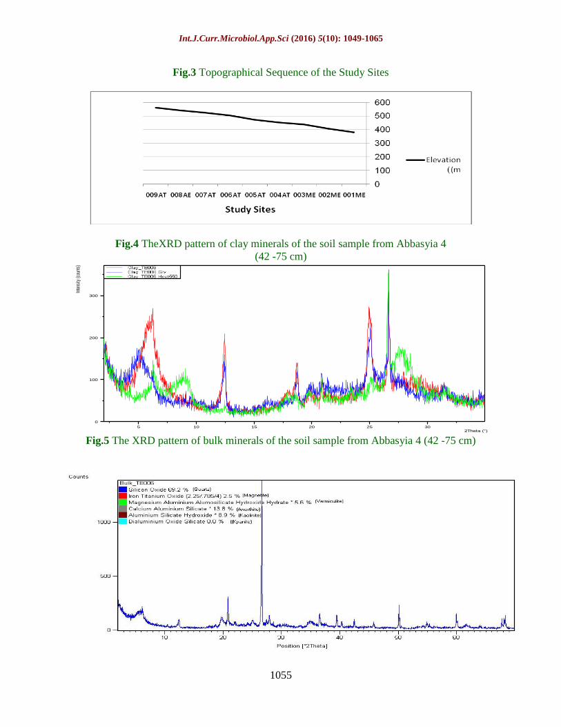
Materials and Methods
Transect along the toposequence stretches in
eastward direction from Al Abbasyia to
Megenis. The area under study is situated
between longitudes 31º00˝ and 32º35˝ East
and latitudes 11º56˝ and 12º09˝ north. Eight
soil samples were collected from eight sites
shown in Table 2 and represented in Figure
2. Sub-scenes of Landsat TM Satellite image
2010 covering the study area were used for
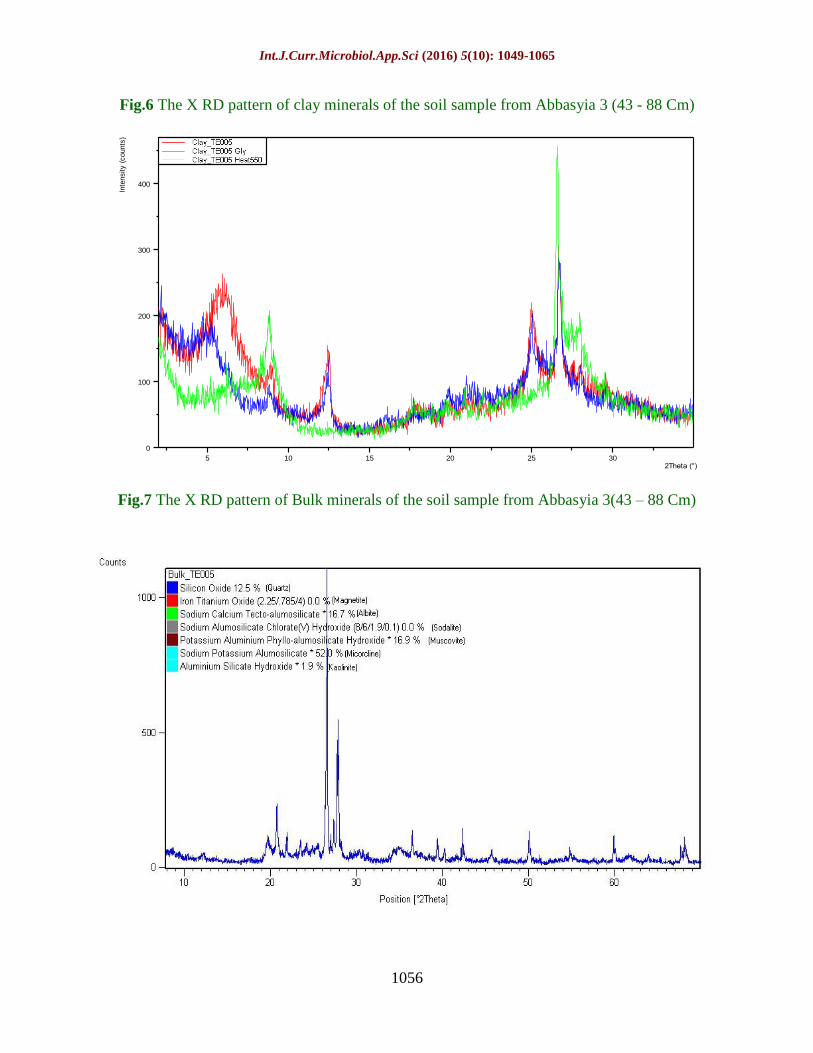
locating the sampling sites. The elevation of
the study sites ranges between 561 and 381
m ASL (Figure 3).
A pit of about 1×2 m in length with 1.5 m
depth was dug for sampling at each site. The
face of the pit to be used for observation,
photographing and sampling should face the
sun. Notes on morphology, horizons
sequence and soil classification were
recorded following the standard procedures.
Soil samples, one from each soil profile/
sample site (Table 2) were selected for
identification of clay mineralogy by x-ray
diffraction. The analysis of clay minerals
took place in two steps, via separation of the
less than 2 µ fraction and then x- ray
diffraction technique. The < 2 µ clay fraction
was filtered through a ceramic filter using a
suction pump. The filtrate was collected in
dishes and kept in an oven at 50 0C for
subsequent analysis. From the wet clay
fraction (< 2µ) oriented mounds were
prepared on glass slides to obtain basal
reflections of clay. The thus prepared glass
slides were kept in desiccators for 24 hours
to dry and then taken for air-drying
measurements (Showgi, 2011; Showgi et al.,
2016).
The x- ray diffraction (XRD) analysis was
used to identify quantitatively and semi-
quantitative the proportion of each clay
mineral with respect to other clay minerals
present in the tested samples. The concise
summary of the application and
interpretation of the XRD techniques that
was provided by Tucker (1988) was
followed and that the qualification of these
minerals was made following Thorez (1972).
The XRD analyses were performed using
Simians D500x–ray diffractometer. The clay
minerals were identified from their 0.01
repeated basal reflections that were obtained
from the XRD patterns after air drying
(normal), glycolation for 48 hours and after
heating to 550 C0
for four hours. The relative
proportion of each mineral was estimated as
provided by Thorez, (1975). The total
association of minerals was taken to be equal
to100 percent. The heights of peaks of the
basal reflection 0.01 of the clay mineral were
measured above the background and
considered as the proportion of that mineral
in the sample. The most basic application of
XRD to sediments is in the analysis of the
Bulk minerals (whole soil samples), to
obtain satisfactory results, the original grain
size must be reduced to a mean particles
diameter of 5 – 10 um with performable a
limited size range. Care must be taken in
particle size reduction. Having ground
representative sample to the appropriate
grain size, the next stage is to present the
sample to the XRD beam.
Results and Discussion
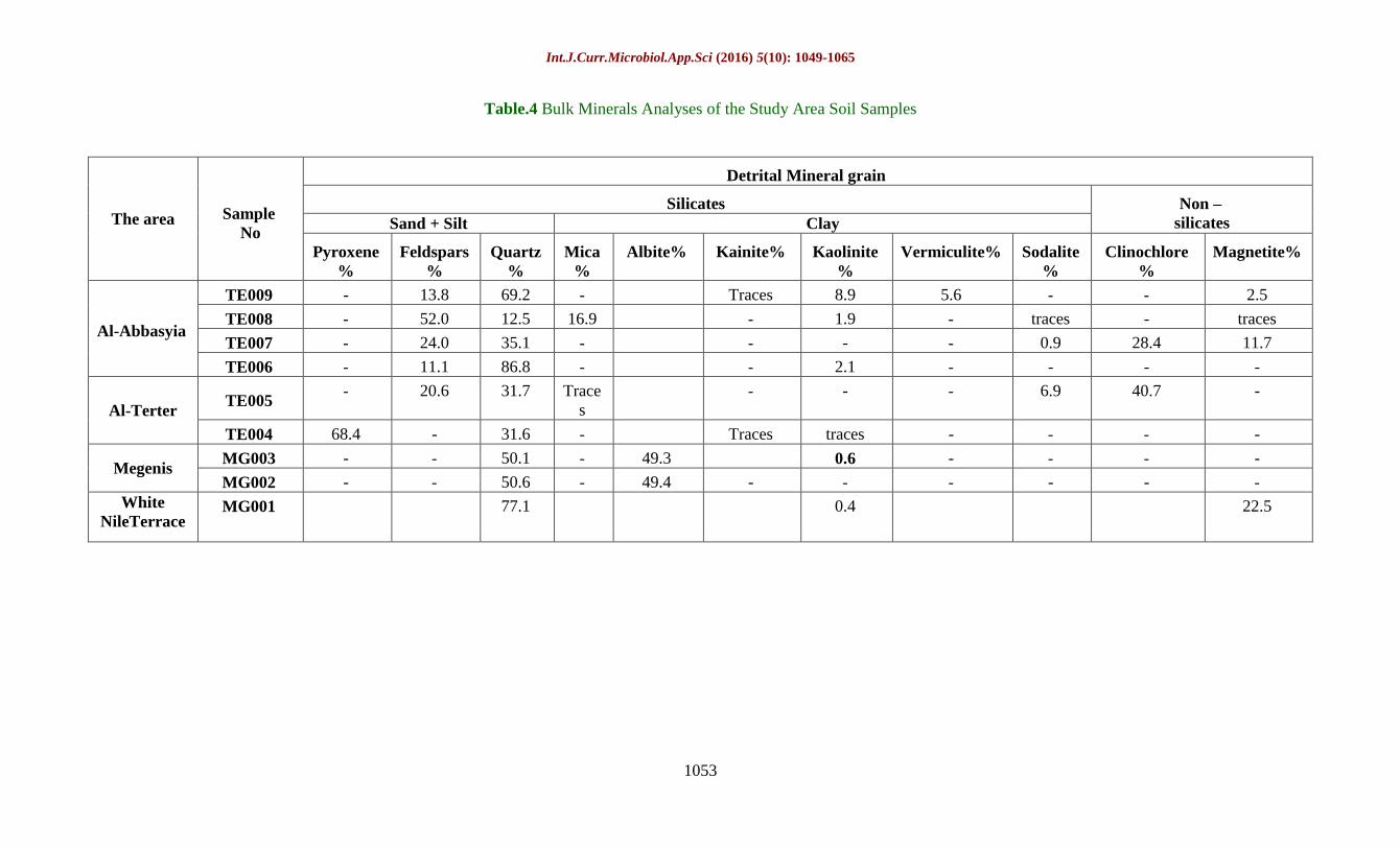
X – Ray diffraction analyses of samples in
these profiles indicates that the dominant
clay mineral is smectite with percentage
range between (71.3 - 36.1%) followed by
kaolinite (46.45 - 22.2 %), chlorite (6.8 - 1.2
%), Illite (15.32 - 2.6 %) and Sme\Chlorite
(6.9 -1.0 %) respectively (Table 4and
Figures 4, 6, 8, 10, 12, 14, 16 and 18). The
bulk mineral analyses indicated that the
presence of high pyroxene is in profile 4
only with percentage of 68.4; quartz is

Int.J.Curr.Microbiol.App.Sci (2016) 5(10): 1049-1065
1052
present in all profiles with percentages of
69.2, 12.5, 35.1, 86.8, 31.7, 31.6, 50.1 and
50.6; feldspar exists in all Profiles except
profile 4, 3 and 2 with percentages of 13.8,
52,0, 24.0,11.1, 20.6; Micais present only in
profile 8 with percentage of 16.9;Kaolinite
exist in Profiles 9, 8, 6 and 3 with
percentages of 8.9, 1.9, 2.1and with traces in
profile 4, Sodalite and clinochlore are
showed only in profiles 7 and 5 with
percentages of (0.9, 6.9). (28.4, 40.7)
respectively; Magnetite exsist in profiles 9, 7
with percentages of 2.5 ,11.7;Albite also
found in profiles 3 and 2 with percentage
49.3 and 49.4; vermiculite exist in profile 9
with percentage 5.6 (Table 5 and Figures 5;
7; 9; 11; 13; 15; 17 and 19).
Table.1 Rainfall at the Study Area
Season Al
Abbasiyia
AL
Terter
Abu
Jubayahah Season
Al
Abbasiyia
AL
Terter
Abu
Jubayahah 1997 – 98 482.4 667.4 573.5 2002– 03 510 509 526
1998 – 99 668 - 472 2003– 04 554.5 499.6 812
1999 – 00 555.6 506 568 2004– 05 532.5 414 661.5
2000 -01 477 483 614 2005– 06 555.7 427 662
2001 – 02 589 711 638 2006– 07 723.3 749.4 671.5
Table.2 Sample sites, location and elevation along the toposequence
Area Sample site North East Elevation (m)
Al Abbasyia, Terter
and
Megenis
(Middle and
lower slope)
AT009 12o08’32.00’’ 31
o18’05.00’’ 561
AT008 12o09’21.00’’ 31
o27’41.00’’ 541
AT007 12o05’09.00’’ 31
o39’35.00’’ 523
AT006 12o03’51.00’’ 31
o44’42.00’’ 503
AT005 11o55’52.00’’ 31
o45’20.00’’ 473
AT004 11o55’57.00’’ 31
o52’28.00’’ 451
ME003 11o56’02.00’’ 32
o15’43.00’’ 437
ME002 11o56’22.00’’ 32
o33’55.00’’ 406
White Nile
Terrace ME001 11
o56’52.00’’ 32
o40’43.00’’ 381
Table.3 Clay Minerals Analyses of Soil Samples from Study area
Area Profile
No
Smectite
%
Kaolinite
%
Illite
%
Chlorite
%
Sme/Chl.
%
Al-
Abbasyia
AT 009 71.0 24.8 2.6 1.2 1.4
AT 008 46.3 34.8 8.4 3.6 6.9
AT 007 65.6 29.0 2.8 1.5 1.1
AT 006 71.3 22.2 3.9 1.2 1.4
Al-Terter AT 005 36.1 46.4 11.6 4.4 1.5
AT 004 64.1 25.4 4.6 3.2 2.7
Megenis MG003 41.00 46.45 10.63 1.95 1.0
MG002 37.01 39.57 15.32 6.8 1.5
White
Nile ME001 85.11 11.5 1.25 0.8 1.34
Int.J.Curr.Microbiol.App.Sci (2016) 5(10): 1049-1065
1053
Table.4 Bulk Minerals Analyses of the Study Area Soil Samples
The area Sample
No
Detrital Mineral grain
Silicates Non –
silicates Sand + Silt Clay
Pyroxene
%
Feldspars
%
Quartz
%
Mica
%
Albite% Kainite% Kaolinite
%
Vermiculite% Sodalite
%
Clinochlore
%
Magnetite%
Al-Abbasyia
TE009 - 13.8 69.2 - Traces 8.9 5.6 - - 2.5
TE008 - 52.0 12.5 16.9 - 1.9 - traces - traces
TE007 - 24.0 35.1 - - - - 0.9 28.4 11.7
TE006 - 11.1 86.8 - - 2.1 - - - -
Al-Terter TE005
- 20.6 31.7 Trace
s
- - - 6.9 40.7 -
TE004 68.4 - 31.6 - Traces traces - - - -
Megenis MG003 - - 50.1 - 49.3 0.6 - - - -
MG002 - - 50.6 - 49.4 - - - - - -
White
NileTerrace MG001 77.1 0.4 22.5
Int.J.Curr.Microbiol.App.Sci (2016) 5(10): 1049-1065
1054
Fig.1 The Study Area at the Eastern and South Eastern Middle and Lower Clay Plains of Nuba
Mountains- South Kordofan State
Fig.2 Landsat scene showing the sampling sites starting from Abbasyia(AT009) on the North
East to Megenis (ME002) on the South East.
AT009 AT008 AT007 AT006 AT005 AT004 ME003 ME002
Abbasyia4 Abbasyia3 Abbasyia2 Abbasyia1 Al Terter2 Al-Terter1 Megenis3 Megenis2
StudyArea
Upper Clay
Plain
South
Kordofan
State
Int.J.Curr.Microbiol.App.Sci (2016) 5(10): 1049-1065
1055
Fig.3 Topographical Sequence of the Study Sites
Fig.4 TheXRD pattern of clay minerals of the soil sample from Abbasyia 4
(42 -75 cm)
5 10 15 20 25 302Theta (°)
0
100
200
300
Inte
nsity
(cou
nts)
Fig.5 The XRD pattern of bulk minerals of the soil sample from Abbasyia 4 (42 -75 cm)
Int.J.Curr.Microbiol.App.Sci (2016) 5(10): 1049-1065
1056
Fig.6 The X RD pattern of clay minerals of the soil sample from Abbasyia 3 (43 - 88 Cm)
5 10 15 20 25 302Theta (°)
0
100
200
300
400
Inte
nsity (
counts
)
Fig.7 The X RD pattern of Bulk minerals of the soil sample from Abbasyia 3(43 – 88 Cm)

Int.J.Curr.Microbiol.App.Sci (2016) 5(10): 1049-1065
1057
Fig.8 The XRD pattern of clay minerals of the soil sample from Abassiyia 2 (58 – 89 Cm)
5 10 15 20 25 302Theta (°)
0
100
200
300
Inte
nsity (
counts
)
Fig.9 The X RD pattern of bulk minerals of the soil sample from Abbasyia 2 (58 - 89 Cm)

Int.J.Curr.Microbiol.App.Sci (2016) 5(10): 1049-1065
1058
Fig.10 The XRD pattern of clay minerals of the soil sample from Abassiyia 1 (57 - 91 Cm)
5 10 15 20 25 302Theta (°)
0
50
100
150
200
250
300
Inte
nsity (
counts
)
Fig.11 The XRD pattern of bulk minerals of the soil sample from Abassiyia 1 (57 – 91 Cm)

Int.J.Curr.Microbiol.App.Sci (2016) 5(10): 1049-1065
1059
Fig.12 The X - RD pattern of clay minerals of the soil sample from Al terter 2 (52 – 85 Cm)
5 10 15 20 25 302Theta (°)
0
50
100
150
200
250
Inte
nsity (
counts
)
Fig.13 The X RD pattern of bulk minerals of the soil sample from Al Terter 2 (52 - 85 Cm)

Int.J.Curr.Microbiol.App.Sci (2016) 5(10): 1049-1065
1060
Fig.14 The XRD pattern of clay minerals of the soil sample from Al Terter 1 (68 -94 cm)
5 10 15 20 25 302Theta (°)
0
100
200
300Inte
nsity (
counts
)
Fig.15 The XRD pattern of bulk minerals of the soil sample from Al Terter 1 (68 -94 cm)
Int.J.Curr.Microbiol.App.Sci (2016) 5(10): 1049-1065
1061
Fig.16 The X RD pattern of clay minerals of the soil sample from Megins 3 (96 -125 cm)
6 8 10 12 14 16 18 20 22 24 26 282Theta (°)
100
200
300
400
Inte
nsity (
counts
)
Fig.17 The X RD pattern of bulk minerals of the soil sample from Al Megins 3 (86 -125 cm)

Int.J.Curr.Microbiol.App.Sci (2016) 5(10): 1049-1065
1062
Fig.18 The XRD pattern of clay minerals of the soil sample from Megins 2 (87 - 125 cm)
4 6 8 10 12 14 16 18 20 22 24 262Theta (°)
100
200
300
400
500
Inte
nsity (
counts
)
Fig.19 The X RD pattern of bulk minerals of the soil sample from Megins 2 (87 -125 cm)

Int.J.Curr.Microbiol.App.Sci (2016) 5(10): 1049-1065
1063
Fig.20 The XRD pattern of clay minerals of the soil sample from White Nile area (68 – 94 cm)
6 8 10 12 14 16 18 20 22 24 26 28 302Theta (°)
100
200
300
400
500
Inte
nsity
(cou
nts)
Fig.21 The XRD pattern of bulk minerals of the soil sample from White Nile area (68 – 94 cm)

Int.J.Curr.Microbiol.App.Sci (2016) 5(10): 1049-1065
1064
The clay minerals analysis by X– Ray
diffraction pattern in profile (MG001) at the
White Nile terrace indicated that the
dominant clay type is smectite with
percentage of 85.11 followed by kaolinite
11.5, chlorite 0.8 illite 1.25 and
semectite\Chrite 1.34 respectively (Table 4,
Figure 20). The bulk minerals analysis
indicates the presence quartz with percentage
of 77.1 kaolinite; 0.4 and magnetite is also
exist with percentage of 22.5. (Table 5,
Figure 21). In conclusion, this research study has been
conducted to characterize and investigated
the mineralogical properties of cracking
clays at Middle and Lower clay plains of
Eastern Nuba Mountains. Eight location
sites were selected for this study; these sites
were along a topographical sequence
starting at the Middle clay plains (Al-
Abbasyiaand Terter area) and ending at
Lower clay Plains (Megenis area) to
compare the types of clay minerals in these
plains. The results indicated that the
Smectite was found to be the dominant clay
minerals. Generally it ranges between (37.0,
- 71.3 %), followed by the kaolinite, the clay
mineral kaolinite was recorded in all of the
investigated samples with variable
percentages ranging between (22.2 % –
46.45 %). Therefore the presence of
Kaolinite indicates accumulation of
weathering product. Investigated soils also
contain low amount chloride, illite and
Smectite\Chlorite.
The sequential weathering of the variable
rock formation has led to the formation of
the clay at different intermountain clay
plains of the Nuba Mountains. It is
anticipated that weathering in the western
high lands areas at middle and lower plains
occurred at variable intensities resulted in
heterogeneous weathering product
indicating that weathering of weatherable
mineral was insufficient to the extent that
remains of interlaying components have
intervene and eventually interlayer the
expandable layer silicates rendering it to
take the characteristic of two minerals e.g.
Montmorillonite and chloride.
The clay fraction of the bulk samples does
not provide indication of smectitic clay
minerals; the Al Abbasyia and Terter areas
contain silicate minerals (mica, kaolinite and
sodalite) and non-silicate minerals
(clinochlore). As well these areas contain
considerable amounts of Feldspars and
Quartz. At the lower clay plains (Megenis)
Albite and Kaolinite The quartz and
magnetite are everywhere ubiquitous; this
distributions pattern would indicate that
Pedogenesis weathering of detrital minerals
grains was rather extensive due to the action
of excessive moisture regimes. White Nile
deposits are characteristically dominated by
Quartz and non-silicate (Magnetite). In
aggregates this mineralogical assemblages
occurring in Middle and Lower clay plains
suggest origins of parent materials derived
from basic igneous\metamorphic rocks that
have under gone weathering and in situ
formation of clay minerals that have
imposed magnitude of variations in the
Pedological features. The mineralogical
analysis of White Nile sample reflect highest
percent of Smectite and Magnetite and
lowest percent of all associated minerals
(Kaolinite, Illite and Chlorite) than all other
site at Middle and lower clay plains
indicating different processes of sorting of
minerals compared to middle and lower clay
plains.
References
Ahmed, N. 1996. Occurrence and distribution of
Vertisols. In Ahmad, N., A. Mermut.
(ed.). Vertisols and technologies for their
management p.1–41. In Soil Science 24,
Elsevier, Amsterdam, the Netherlands.

Int.J.Curr.Microbiol.App.Sci (2016) 5(10): 1049-1065
1065
Balwant, S. and H. Susan. 2002. Layer charge
characteristics of Smectite from Vertisol
of New South Wales. Australian J. Soil
Res., 40(7): 1159 – 1170.
Caillaud, J.D.D., Proust, Righi, F., Martin.
2004. Fe-Rich Clays In A Weathering
Profile Developed From Serpentinite Clay
And Clay Minerals; v. 52; no. 6; p. 779-
791.
Chizhikova, N.P. 2005. Vertisols of Cuba:
Mineralogical Composition and Response
to Agrogenic Impacts (Plowing, Irrigation,
and Fertilization) Eurasian Soil Sci., Vol.
38, No.10, pp. 1048-1057.
Dudal, R., H. Eswaran. 1988. Distribution
Properties and Classification of the
Vertisols In: Wilding L.P, Puentes R,
editors. Vertisols: their distribution,
properties, classification and management.
College Station, Texas: Texas A&M
University Printing Center.
Grim, R.E. 1968. Clay mineralogy 2nd
ed. New
York, M c: G raw-Hill, p.p. 596.
Mc Garry, D. 1996. The Structure and Grain
Size Distribution of Vertisols, In:
Vertisols and Technologies for Their
Management (Eds.: N. Ahmad and A.
Mermut). Developments on Soil
Science.Vol. 24. Elsevier, Amsterdam, pp.
231-259. Kladivko E.J. (2001). Tillage
Systems and Soil Ecology, Soil Tillage
Res. 61, 61-76.
Moore, D.M, R.C. Jr Reynolds. 1989. X-ray
Diffraction and the Identification and
Analysis of Clay Minerals. Oxford,
Oxford University Press, 332 pp.
Osman, R.A. 2006. Mineralogical
Characterization of Some Soil Samples
From East of Khartoum North (Sudan).
Thesis Submitted In Partial Fulfilled Of
the Requirement for the Degree of Master
Science, Faculty of Agricultural Sciences
University of Gazira.
Pacheco and Dawoud, H.A. 1976. Exploratory,
Soil Survey of North and South Kordofan
Ministry of Agriculture Fisheries and
Forestry. Soil Survey Administration Wad
Medani, Sudan
Showgi, Omima, O.A. 2011. A study on
properties and genesis ofcracking clay
soils in Southern Kordofan, Sudan. Ph.D.
Thesis (soil Science), Soil and Water
Science Dept., College of Agricultural
Studies. Sudan University of Science and
Technology. Khartoum.
Showgi, Omima Omer, A., M. Ali, El-Abbas
Doka, Dawoud, Hashim Ali and
Mohamedain, Mahgoub Suliman. 2016.
Mineralogical Properties of Cracking Clay
Soils along Toposequence at Northern
Upper Clay Plains of Nuba Mountains
South Kordofan, Sudan. Int. J. Curr.
Microbiol. App. Sci., 5(8): 745-759.
doi:http://dx.doi.org/10.20546/ijcmas.201
6.508.084
Thorez, J. 1972. Practical Identification of Clay
Minerals, First Edition G. Lelotte Dison
Belgium.
Thorez, J. 1975. Phyllosilicates and Clay
Minerals A Laboratory Handbook for
Their X-Ray Diffraction Analysis Dison,
Editions G. Lelotte, pp. 579
Tucker, M. (ed) 1988. Techniques in
Sedimentology.Blackweel Scientific
Publications California, .U .S .A.
Vail, J.R., D.C. Rex. 1971. Tectonic and Geo-
chronological Studies in Sudan.14th annual
Republic. Inst Afr. Geol. Univ Leeds, 44 -
47.
How to cite this article:
El-Abbas Doka M. Ali, Omima Omer A. Showgi, El Tag Fadlalla A. Rahim and Mahgoub
Suliman Mohamedain. 2016. Mineralogical Properties of Cracking Clay Soils along
Toposequence at Middle and Lower Clay Plains of Eastern Nuba Mountains South Kordofan,
Sudan. Int.J.Curr.Microbiol.App.Sci. 5(10): 1049-1065.
doi: http://dx.doi.org/10.20546/ijcmas.2016.510.111


![Doka Catalogue[1]](https://static.fdocuments.us/doc/165x107/5571f30d49795947648d694d/doka-catalogue1.jpg)