Low-Cost Bus Tracking System overhauled en route … Scholar, Kalinga University, Raipur, India. Dr....
14
Advances in Computational Sciences and Technology ISSN 0973-6107 Volume 10, Number 5 (2017) pp. 1139-1151 © Research India Publications http://www.ripublication.com Low-Cost Bus Tracking System overhauled en route Area-Trace to Atomic Hypothesis Algorithm LCBTS using AHA Darshan Ingle Research Scholar, Kalinga University, Raipur, India. Dr. A. B. Bagwan Research Guide, Kalinga University, Raipur, India. Professor & HOD, Dept. of Comp. Engg., JSPM’S R.S.C.O.E, Tathwade, Pune, Maharashtra, India Abstract Buses are indispensable means of transport in every metropolitan city. In fact, they are the inexorable resources of every condensed populated city. Knowing its importance, it is the need of the hour to have a mechanism that can keep a track of the buses running in the city for the convenience of the people. This paper proposes an advanced algorithm which has a better efficiency than the previously published algorithm [2]. The notion of this algorithm was devised from the fundamental theory of chemistry and its roots are derived from Neil Bohr Atomic Model. This algorithm not only gives better results but also yields results expeditiously. It uses the foundation of the Area Trace algorithm and revamps it to further enhance the potential of the algorithm. The model addresses two parts viz a GPS-GSM Module and a Traffic Management System Module. The former model deals with the analysis and estimation of the exact timely locating of the bus and the latter one is accountable for calculating the average estimated time to required destination. This paper shows the results of Atomic Hypothesis Algorithm (AHA) and discerns it from the Area Trace Algorithm. Keywords: GPS-GSM, Atomic Hypothesis Algorithm, Area Trace Algorithm, Silver Cloud Real-Time GPS tracker, Compound Splitting technique, Traffic Management System, Vicenty distance
Transcript of Low-Cost Bus Tracking System overhauled en route … Scholar, Kalinga University, Raipur, India. Dr....

Advances in Computational Sciences and Technology
ISSN 0973-6107 Volume 10, Number 5 (2017) pp. 1139-1151
© Research India Publications
http://www.ripublication.com
Low-Cost Bus Tracking System overhauled en route
Area-Trace to Atomic Hypothesis Algorithm LCBTS
using AHA
Darshan Ingle
Research Scholar, Kalinga University, Raipur, India.
Dr. A. B. Bagwan
Research Guide, Kalinga University, Raipur, India.
Professor & HOD, Dept. of Comp. Engg., JSPM’S R.S.C.O.E, Tathwade, Pune, Maharashtra, India
Abstract
Buses are indispensable means of transport in every metropolitan city. In fact,
they are the inexorable resources of every condensed populated city. Knowing
its importance, it is the need of the hour to have a mechanism that can keep a
track of the buses running in the city for the convenience of the people. This
paper proposes an advanced algorithm which has a better efficiency than the
previously published algorithm [2]. The notion of this algorithm was devised
from the fundamental theory of chemistry and its roots are derived from Neil
Bohr Atomic Model. This algorithm not only gives better results but also
yields results expeditiously. It uses the foundation of the Area Trace algorithm
and revamps it to further enhance the potential of the algorithm. The model
addresses two parts viz a GPS-GSM Module and a Traffic Management
System Module. The former model deals with the analysis and estimation of
the exact timely locating of the bus and the latter one is accountable for
calculating the average estimated time to required destination. This paper
shows the results of Atomic Hypothesis Algorithm (AHA) and discerns it
from the Area Trace Algorithm.
Keywords: GPS-GSM, Atomic Hypothesis Algorithm, Area Trace Algorithm,
Silver Cloud Real-Time GPS tracker, Compound Splitting technique, Traffic
Management System, Vicenty distance

1140 Darshan Ingle and Dr. A. B. Bagwan
I. INTRODUCTION
Buses are among one of the most customary ways used by the commuters to travel in
a metropolitan city, off course train being one of the others. However, not every city
has a strong connectivity of trains like Mumbai. If we consider a city like Pune or
Bangalore, these cities do not have a local train for daily travel. Therefore, the
commuters are left with two choices, either traveling by their own car or opt for a bus.
Not every person can afford a car and so it cannot add on to the convenience of every
person. Secondly, if we have a close insight into the city's traffic conditions, it's very
frantic to drive in such cities. As per the 2015 statistics of Pune city with a current
population of 5,926,606, almost 60 percent of the population uses Pune Municipal
Transport (PMT) buses. This clearly indicates that buses form one of the vital assets
for the people of Pune. The situation happens to be more or less the same with other
cities like Bangalore or Mumbai. However, the frequency of the buses is not at par to
suffice the thirst of the commuters. Buses are overcrowded. Many times, they are
delayed due to substandard traffic conditions. So there is a strong need of having a
full proof system to take care of such issues.
One such system has been systematically drafted in my previous work [1] which deals
with tracking of the bus and estimating its likely time of arrival. The work published
in [1] is a successful extension of my previous work [2], which uses Area Trace
Algorithm to predict the exact location of the bus. Area Trace Algorithm is a powerful
yet distinguished method of obtaining the location of the bus. In this paper, we will be
presenting Atomic Hypothesis Algorithm (AHA) which is a more advanced algorithm
compared to Area Trace Algorithm. This algorithm is not only powerful than the Area
Trace Algorithm but also achieves better time efficiency over it.
In this paper, we will be discussing this algorithm comprehensively. The flow of the
paper is as follows. An immense review of the literature survey done for this paper is
published in Section II. Section III discusses the Objective, Overview and architecture
of the system and its block diagram. Section IV talks of the need and the flow of the
algorithm. Section V discusses the results obtained when tested in the city of Pune.
Findings and Conclusion follow in Section VI.
II. RELATED WORK
Traffic in an urban city causes a bottleneck and the whole traffic movement becomes
very sluggish. Mumbai is one of such city which faces these issues. Buses being one
of the best ways in commuting such cities, the system developed was able to not only
track the location of the bus but also measure the Expected time of arrival for the bus.
The system aims at developing a low-cost solution for every user to obtain the
information of the bus transport with the following set of essential parameters like the
current bus location, the seating capacity of the bus, maximum available standees
allowed in the bus, current count of passengers and the expected arrival time of the
bus. The system also provides the user with the fare between any source and
destination [1]. It uses a Silver Cloud Real-time GPS tracker which can track the

Low-Cost Bus Tracking System overhauled en route Area-Trace to Atomic.. 1141
current location of the bus. The data is sent via GPRS to the server using the POST
method of the HTTP protocol. A web application was developed using JavaScript,
Ajax, and MySQL and Google Maps was incorporated in it [1].
Low-cost bus tracking using Area Trace Algorithm allows the user to know the
current location of the bus using an elementary mobile phone without using any data
connection [2]. This algorithm simply makes use of Short Message Service (SMS)
which is sent to the server for interpretation. The Server interprets the SMS and
calculates the bus location and its expected time of arrival. It further sends the
assigned name of the location to the user in SMS format using its helper module. Area
trace algorithm is one of the innovative approach to calculate the bus location and has
successfully shown satisfactory results in [1].
Another algorithm namely Cell Based Algorithm [3] was implemented in the city of
Bangkok. This algorithm divided the entire Bangkok area into 6400 square cells. For
prognosticating the travel path, it used the A* algorithm and incremental weighted
update algorithm was used to calculate the time of travel.
Circle Split Method was used in a GPS mounted vehicle and a map matching
technique was used. The map was deeply researched and it was divided different areas
with certain circles. The shapes and dimensions of the areas were estimated by the
centers and the radiuses [4].
As per the work published by the Cyprus Research Promotion Foundation's
Framework Programme for Research, Technological Development and Innovation
(DESMI 2008), Event Based Bus Monitoring System (EBM) focuses more
specifically on minimizing the communication signals to achieve an adequately
accurate monitoring of bus arrival times [5]. The results of EBM show that it uses
only 3.5% of the total volume of signaling messages, thereby reducing it to a
significant extent.
The work in [6] shows Real Time Bus Monitoring and Passenger Information bus
tracking device which obtains the GPS data of bus locations and display it on the
GLCD as per the passengers request. Further, GHOST (Galileo EnHancement as
BoOster Of the Smart CiTes) [7] which is an Intelligent Transport System (ITS) was
able to exploit the geo-referenced information of the urban elements and monitor
them in a smart, continuous and an autonomous way.
Mobile Enterprise Sensor Bus (M-ESB) [8] uses a multi-sensor data acquisition and
sharing interface for a mobile sensor grid and router which feed into the remote data
cloud. It also proposes a new mobile service model for the public bus company to act
as a Virtual Mobile Service operator. Vehicle Traffic Monitoring using Wireless
Sensor Network in South Africa [9] presents the use of WSN technology as a tool for
controlling the traffic signals between Johannesburg and Pretoria. Additionally, RFID
scanners are also used in the system to identify the congested areas and accordingly
inform the traffic officer at the Traffic Monitoring System. The traffic officer can in
return decide and suggest the best route for the motorists.

1142 Darshan Ingle and Dr. A. B. Bagwan
United States of America has a bus tracking system called Next Bus [11] wherein a
user can register and login to know the estimated arrival time of any bus at any bus
stop. The lacuna of the system is that it does not tell the user the exact location of the
bus but just tries to satisfy him with the time left for arrival.
III. SYSTEM ARCHITECTURAL MODEL
A. Objective The main objective of the system aims at developing a low-cost panacea for people of
all categories to avail a shrewd solution for knowing the Expected Arrival Time for a
bus. As discussed before, Pune and Mumbai are desperately in need of a system that
can help them in knowing the bus arrival time. Time is a crucial parameter for people
living in these cities. If they can get the expected arrival time for the next bus, they
can decide upon whether to wait for that bus or choose some other means of transport
like a rickshaw or taxi.
As per the Government norms for running a smooth transportation, buses are assigned
proper timings on each route, but rarely are the buses seen following that timetable.
This serious issue is seen not due to the fault of the Government but due to the Traffic
seen in every nook and corner of the city. Lastly, bus stops are overcrowded many
times and people need to wait for the bus in scorching sunlight, which paves way for
serious maladies like sun stroke.
The last but not the least advantage of the system is its low-cost solution. For any user
to avail the developed system, he/she need not have a costly smart phone. A basic
mobile handset will do the job as smartly and relentlessly as a smart phone.
B. Overview
The system uses Silver Cloud Real-time GPS tracker to fetch the bus's location at any
point of time. POST method of HTTP protocol is used for sending data to the server
by GPRS. JavaScript, Ajax, and MySQL are used for the development of the
software. Google contributed extensively for propping the system.
As discussed above, the user just needs to send a sms in a specified format as "BUS
bus_number nearest_busstop" to a specified toll-free number and the system would in
turn calculate all the required details and send him back the required information in a
standard format as "BUS bus_number nearest_bus_stop_for_bus_location AV-
SEATS max_count STANDEE max_standee_allowed PASS
current_count_of_passengers TIME expected_arrival_time", where BUS stands for
bus number requested, LOC gives the nearest location where the bus is located, AV-
SEATS shows the maximum number of seats available in that bus, STANDEE gives
the count of maximum number of passengers who are allowed to travel standing in the
bus, PASS gives the current number of passengers travelling in that bus and TIME
gives the expected arrival time for the bus [1]. This paper presents the advanced work
done on [1].
Low-Cost Bus Tracking System overhauled en route Area-Trace to Atomic.. 1143
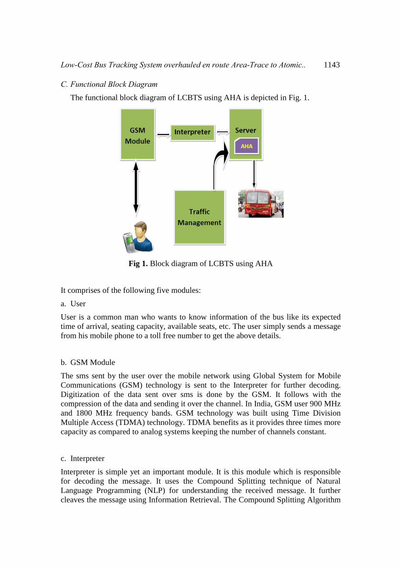
C. Functional Block Diagram The functional block diagram of LCBTS using AHA is depicted in Fig. 1.
Fig 1. Block diagram of LCBTS using AHA
It comprises of the following five modules:
a. User
User is a common man who wants to know information of the bus like its expected
time of arrival, seating capacity, available seats, etc. The user simply sends a message
from his mobile phone to a toll free number to get the above details.
b. GSM Module
The sms sent by the user over the mobile network using Global System for Mobile
Communications (GSM) technology is sent to the Interpreter for further decoding.
Digitization of the data sent over sms is done by the GSM. It follows with the
compression of the data and sending it over the channel. In India, GSM user 900 MHz
and 1800 MHz frequency bands. GSM technology was built using Time Division
Multiple Access (TDMA) technology. TDMA benefits as it provides three times more
capacity as compared to analog systems keeping the number of channels constant.
c. Interpreter
Interpreter is simple yet an important module. It is this module which is responsible
for decoding the message. It uses the Compound Splitting technique of Natural
Language Programming (NLP) for understanding the received message. It further
cleaves the message using Information Retrieval. The Compound Splitting Algorithm
1144 Darshan Ingle and Dr. A. B. Bagwan
considers words found in the lexicon as possible parts and automatically determines
which split is beneficial for retrieval [10].
Interpreter also encodes the message to be sent back to the User Module over GSM.
This encoded message is a format which is easy for any user to understand. The same
has been discussed above in this section.
d. Server
The server receives the decoded message from the server which has details about the
bus number whose location needs to be fetched. The server pings the tracker using
POST method of the HTTP protocol asking for its current location The tracker on the
bus immediately sends its location to the server.
Server now calls the AHA for knowing the buses that are nearby the requested current
location. AHA cleverly computes by processing only the required nodes in the space
rather than all the nodes unlike the former Area Trace algorithm [1].
Finally, based on the periodic information received from the Traffic Management
module and the AHA calculations, it acquires all the required information about that
bus. This entire information is returned by the server to the Interpreter Module.
e. Traffic Management
The AHA calculates its distance based on the Vincenty distance [12] and Traffic
Management module helps to cluster this data. We do not get into the details of this
module here. The working of this module remains same as in [1].
IV. ALGORITHM
A. Exigency The existing algorithm for available for calculating the estimated arrival time of bus
namely Area Trace Algorithm has a drawback that it reckons the distance from all
possible bus stops located in its vicinity based on the input parameters received for the
algorithm. This increases the computations for calculations. Also, the processing time
of the algorithm increases. The algorithm, no doubt, being robust and fault tolerant,
takes more time for fetching the results.
B. Working Area Trace algorithm [1] divides the entire bus route of Mumbai into a hardcoded
fixed number of areas using its classification parameters. These parameters do work
in the practical scenario, but they eventually end up consuming more time, thereby
increasing the number of computations.
Low-Cost Bus Tracking System overhauled en route Area-Trace to Atomic.. 1145
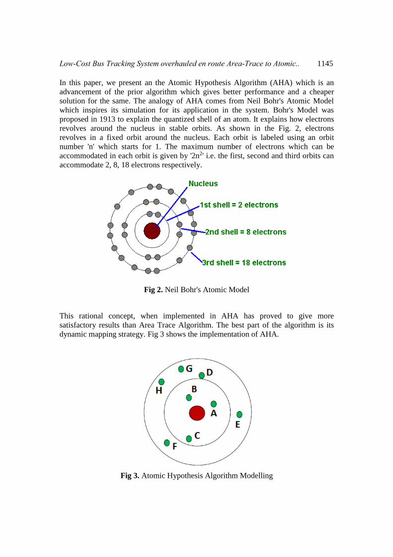
In this paper, we present an the Atomic Hypothesis Algorithm (AHA) which is an
advancement of the prior algorithm which gives better performance and a cheaper
solution for the same. The analogy of AHA comes from Neil Bohr's Atomic Model
which inspires its simulation for its application in the system. Bohr's Model was
proposed in 1913 to explain the quantized shell of an atom. It explains how electrons
revolves around the nucleus in stable orbits. As shown in the Fig. 2, electrons
revolves in a fixed orbit around the nucleus. Each orbit is labeled using an orbit
number 'n' which starts for 1. The maximum number of electrons which can be
accommodated in each orbit is given by '2n2' i.e. the first, second and third orbits can
accommodate 2, 8, 18 electrons respectively.
Fig 2. Neil Bohr's Atomic Model
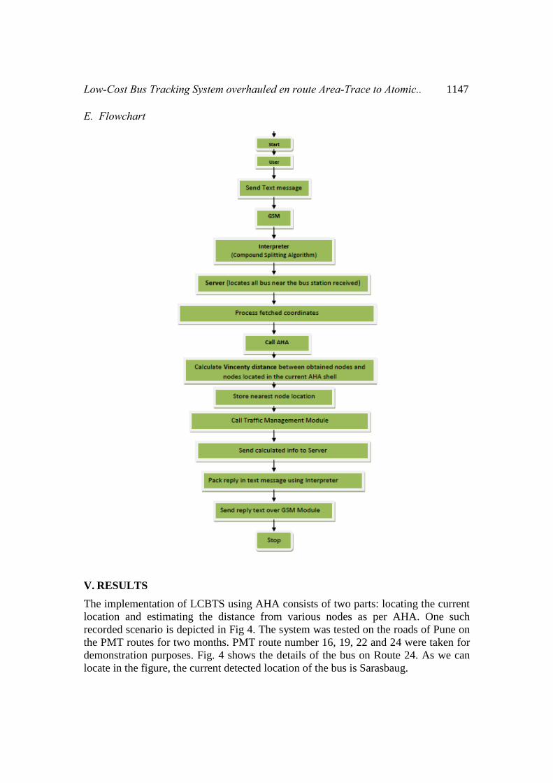
This rational concept, when implemented in AHA has proved to give more
satisfactory results than Area Trace Algorithm. The best part of the algorithm is its
dynamic mapping strategy. Fig 3 shows the implementation of AHA.
Fig 3. Atomic Hypothesis Algorithm Modelling

1146 Darshan Ingle and Dr. A. B. Bagwan
Server pings the tracker and obtains the current location of the bus. The call is now
given to AHA for calculating the nearest bus stops to the current location. AHA takes
as input the current location and fetches the map of the all marked bus stops in its
database. The AHA quantizes the maps into shells like the Bohr's model. AHA
decides the value of n dynamically depending upon the bus location received. If the
received location resides in a densely populated unit where the number of residents is
more, naturally the number of bus stops will be high. In such cases, the radius of the
first and second shell is chosen as 0.3 miles and 0.6 miles respectively. Whereas for a
sparely populated unit, the radius of the first and second shell is chosen as 0.5 miles
and 0.8 miles respectively. These units are selected very carefully after several
iterations. Trial and error have proved out this to be a best mentioned values of the
orbit suiting for Pune Municipal Transport (PMT).
In the former case of densely populated unit from Fig 3, AHA only chooses the nodes
A and B ignoring node C, it being farer. It further calculates the Vincenty distance
between the current location and the nodes A and B to find the nearest node based on
the latitudinal and longitudinal distance calculated. In case, if the algorithm fails to
locate two nodes in the first orbit, it increases its tour to the next level of orbit. The
same procedure is repeated for the area covered in this shell. The algorithm is proven
to give results in a maximum value of 'n' ranging up to 2.
C. Algorithm 1. Read current input location of the bus.
2. Decide the area as being densely or sparsely populated.
3. For 1st orbit, locate a maximum of two nodes.
4. Calculate Vincenty distance between those points and store the least one.
5. If the first orbit doesn't locate two nodes, move to second orbit and locate a
maximum of eight nodes. Repeat Step 4.
6. Return result to the server.
D. Vicenty distance Various distance measures like Vicenty, Great circle, Haversine; are available for
calculating the distance between any two nodes on the maps. Vicenty distance proves
to be of more practical use among these as it gives more practical results. the error in
Vincenty is just 6 μm as compared to great circle which gives a value of 0.75 m [12].
Low-Cost Bus Tracking System overhauled en route Area-Trace to Atomic.. 1147
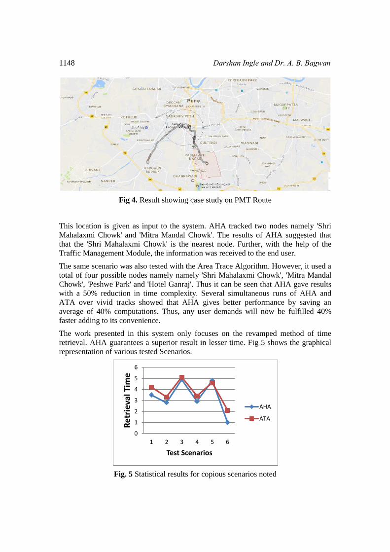
E. Flowchart
V. RESULTS
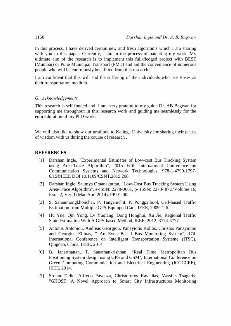
The implementation of LCBTS using AHA consists of two parts: locating the current
location and estimating the distance from various nodes as per AHA. One such
recorded scenario is depicted in Fig 4. The system was tested on the roads of Pune on
the PMT routes for two months. PMT route number 16, 19, 22 and 24 were taken for
demonstration purposes. Fig. 4 shows the details of the bus on Route 24. As we can
locate in the figure, the current detected location of the bus is Sarasbaug.
1148 Darshan Ingle and Dr. A. B. Bagwan
Fig 4. Result showing case study on PMT Route
This location is given as input to the system. AHA tracked two nodes namely 'Shri
Mahalaxmi Chowk' and 'Mitra Mandal Chowk'. The results of AHA suggested that
that the 'Shri Mahalaxmi Chowk' is the nearest node. Further, with the help of the
Traffic Management Module, the information was received to the end user.
The same scenario was also tested with the Area Trace Algorithm. However, it used a
total of four possible nodes namely namely 'Shri Mahalaxmi Chowk', 'Mitra Mandal
Chowk', 'Peshwe Park' and 'Hotel Ganraj'. Thus it can be seen that AHA gave results
with a 50% reduction in time complexity. Several simultaneous runs of AHA and
ATA over vivid tracks showed that AHA gives better performance by saving an
average of 40% computations. Thus, any user demands will now be fulfilled 40%
faster adding to its convenience.
The work presented in this system only focuses on the revamped method of time
retrieval. AHA guarantees a superior result in lesser time. Fig 5 shows the graphical
representation of various tested Scenarios.
Fig. 5 Statistical results for copious scenarios noted
0
1
2
3
4
5
6
1 2 3 4 5 6
Ret
riev
al T
ime
Test Scenarios
AHA
ATA

Low-Cost Bus Tracking System overhauled en route Area-Trace to Atomic.. 1149
VI. CONCLUSIONS
LCBTS using AHA offers a low-cost solution for the common man. We are mainly
focusing in this paper in developing a low-cost solution for the common man as well
as a system which is more robust and fault tolerant. Atomic Hypothesis Algorithm
purifies the Area Trace algorithm giving more better results.
The future work of this system is to build a GLCD screen to be displayed at each bus
stop displaying the arrival time for each expected bus by using a minimum number of
computations. Also, developing an android app for reducing the retrieval time is
another milestone to be achieved.
VII. DECLARATIONS
A. Ethics approval and consent to approval We voluntarily agree to participate in the research and give informed consent for
enrolling in the journal contribution.
B. Consent for Publication We, the authors of 'LCBTS Using AHA' , give the guarantee for novel work and
grant 'Human centric computing and Information Sciences' consent for
publication.
C. Availability of data and material Not applicable.
D. Competing interests Not applicable
E. Funding
The research is completely self funded.
F. Authors contribution
This paper is a part of my PhD Research work at Kalinga University, Naya Raipur,
Chattisgarh. I am a Professor working with Mumbai University. I have been working
extensively on this project since last 2 years and have done considerable contribution
to the same in IEEE digital Xplore.
1150 Darshan Ingle and Dr. A. B. Bagwan
In this process, I have derived certain new and fresh algorithms which I am sharing
with you in this paper. Currently, I am in the process of patenting my work. My
ultimate aim of the research is to implement this full-fledged project with BEST
(Mumbai) or Pune Municipal Transport (PMT) and aid the convenience of numerous
people who will be enormously benefitted from this research.
I am confident that this will end the suffering of the individuals who use Buses as
their transportation medium.
G. Acknowledgements This research is self funded and I am very grateful to my guide Dr. AB Bagwan for
supporting me throughout in this research work and guiding me seamlessly for the
entire duration of my PhD work.
We will also like to show our gratitude to Kalinga University for sharing their pearls
of wisdom with us during the course of research .
REFERENCES
[1] Darshan Ingle, "Experimental Estimates of Low-cost Bus Tracking System
using Area-Trace Algorithm", 2015 Fifth International Conference on
Communication Systems and Network Technologies, 978-1-4799-1797-
6/15©IEEE DOI 10.1109/CSNT.2015.268.
[2] Darshan Ingle, Saumya Omanakuttan, "Low-Cost Bus Tracking System Using
Area-Trace Algorithm", e-ISSN: 2278-0661, p- ISSN: 2278- 8727Volume 16,
Issue 2, Ver. I (Mar-Apr. 2014), PP 01-00.
[3] S. Sananmongkhonchai, P. Tangamchit, P. Pongpaibool, Cell-based Traffic
Estimation from Multiple GPS-Equipped Cars, IEEE, 2009, 1-6.
[4] Hu Yue, Qin Yong, Lv Yuqiang, Dong Honghui, Xu Jie, Regional Traffic
State Estimation With A GPS-based Method, IEEE, 2012, 3774-3777.
[5] Antonis Antoniou, Andreas Georgiou, Panayiotis Kolios, Christos Panayiotou
and Georgios Ellinas, " An Event-Based Bus Monitoring System", 17th
International Conference on Intelligent Transportation Systeme (ITSC),
Qingdao, China, IEEE, 2014.
[6] B. Janarthanan, T. Sanathankrishnan, "Real Time Metropolitan Bus
Positioning System design using GPS and GSM", International Conference on
Green Computing Communication and Electrical Engineering (ICGCCEE),
IEEE, 2014.
[7] Srdjan Tadic, Alfredo Favenza, Christoforos Kavadias, Vassilis Tsagaris,
"GHOST: A Novel Approach to Smart City Infrastructures Monitoring
Low-Cost Bus Tracking System overhauled en route Area-Trace to Atomic.. 1151
Through GNSS Precise Positioning", 978-1-5090-1846-8/16/$31.00
IEEE©2016.
[8] Lin Kang, Stefan Poslad, Weidong Wang, Xiuhua Li,Yinghai Zhang,"A
Public Transport Bus as a Flexible Mobile Smart Environment Sensing
Platform for IoT", 978-1-5090-4056-8/16 $31.00 © 2016 IEEE.
[9] Munienge Mbodila, Ekabua Obeten, Isong Bassey, "Implementation of Novel
Vehicles’ Traffic Monitoring Using Wireless Sensor Network in South
Africa", ©2015_ IEEE.
[10] Joachim Daiber, Lautaro Quirozy, RogerWechslery, Stella Frank, "Splitting
Compounds by Semantic Analogy", Creative Commons Attribution 4.0
International License.
[11] www.nextbus.com, © 2016 NextBus Inc.
[12] http://gis.stackexchange.com/questions/84885/whats-the-difference-between-
vincenty-and-great-circle-distance-calculations

1152 Darshan Ingle and Dr. A. B. Bagwan