
Long Term Monitoring of Landuse/Landcover Through...
41
Long Term Monitoring of Landuse/Landcover Through Remote Sensing and Geographical Information System in Great Himalayan National Park, Himachal Pradesh Suneet Naithani & V. B. Mathur Wildlife Institute of India, Post Box # 18, Chandrabani, Dehra Dun - 248 001, U.P., INDIA April 1998 FREEP-GHNP 06/24
Transcript of Long Term Monitoring of Landuse/Landcover Through...

FREEP-GHNP Research Project
41
Long Term Monitoring of Landuse/Landcover
Through Remote Sensing and Geographical
Information System in Great Himalayan
National Park, Himachal Pradesh
Suneet Naithani & V. B. MathurWildlife Institute of India,
Post Box # 18, Chandrabani,Dehra Dun - 248 001, U.P., INDIA
April 1998
FREEP-GHNP 06/24

FREEP-GHNP Research Project
40
CONTENTS
Page
1.0 INTRODUCTION 1
2.0 MONITORING 2
2.1 Role of Remote Sensing in Monitoring 2
2.2 Significance 2
2.3 Indicators 3
3.0 METHODS OF LAND USE/LANDCOVER MONITORING 3
4.0 CONCLUSION 4
5.0 REFERENCES 5
Table 1 : Monitoring of Major vegetation types and grasslands 6
APPENDIX 1a : Steps in Landuse/Cover Mapping Through 7
Visual Interpretation
APPENDIX 1b : Flow chart of change detection in Landuse/Cover Mapping 8
APPENDIX 2a-2c : Interpretation key 9
APPENDIX 3a-3c : Classification scheme 13
APPENDIX 4a-4j : Landuse/Landcover of GHNP, Ecozone, Tirth,
Sainj and change detection
APPENDIX 5a-5j : Arial estimation of landuse/landcover of GHNP, 17
ecozone, Thirth, Sainj and grasslands through
climatic zones
APPENDIX 6 : Abstract for teaching material for training 36
workshop in GHNP.
APPENDIX 7a : Monitoring approach through remote sensing and 37
Geographical information system
APPENDIX 7b : Man days required for vegetation and grasslands 38
mapping through remote sensing and GIS.
APPENDIX 7c : Tentative expenditure in consultancy/project mode 39
for one theme.
FREEP-GHNP Research Project
1
1.0 INTRODUCTION
The Himalaya is one of the most fragile Ecosystem on the earth. The dwindling forests have
had a serious impact on wildlife resources because of loss of habitat. Management of wildlife
depends on the basic understanding of biotic and abiotic elements of habitat such as animal,
vegetation, water, soil, geomorphology and geology etc.
There is a need to develop an integrated approach to both management and conservation of
wildlife. This is often the area of great interest to ecologists and conservationist who are
invariably concerned about external pressure on wildlife and threats to its continued survival.
The basic aim of Forestry Research Education and Extension Project in the Great Himalayan
National Park (GHNP) is to conserve biological diversity whilst fulfilling the needs of local
through an Ecodevelopment approach. Mapping of major vegetation communities is one of
the objective of task no. 5 using Remotely Sensed Data including broad density classes. The
park has been classified through visual interpretation into 11 forest and 12 non forest classes
( Naithani & Mathur, unpublished). Density classes are as per the FSI norms, closed forest :
canopy cover >40% and open forest : canopy cover 10 - 40%. The detailed classification
based on floral inventory which is in progress ( Singh & Rawat, unpublished).
On the basis of visual interpretation with limited ground checks, the Satellite data FCC ( False
Colour Composite paper print) on 1: 50,000 scale of IRS IB of 1993 with standard band
combination has been used for the study. The season chosen is Sept/Oct, which is appropriate
for doing studies in higher Himalayan region. The ancillary data Survey Of India toposheets on
1:50,000 scale 53E/5, 53E/6, 53E/9, 53E/10, 53E/13 and 53E/14, Park map, Management
plan and existing thematic maps were use to prepare the final vegetation map.
The whole park is divided into an Ecodevelopment Zone, Sainj sanctuary, Tirthan sanctuary
and main Great Himalayan National Park. Along with a generation of above layers the change
detection analysis for the Ecodevelopement Zone has been done on 1961 SOI toposheets
and 1993 satellite data paper print on 1:50,000 scale. It reveals that the overall change is
about 12.79% and the increased area is about 8.48%. The decreased area is about 4.31%
(Naithani & Mathur unpublished). The following layers for all the areas have been prepared
with area statistics density classes, and are shown in the Appendices.They include
* Vegetation map, Cover density map, Contour map, Drainage map, Slope map, Aspect
map, Digital Terrain Model and a Geologycal map.
For continuous & accurate monitoring of vegetation Remote Sensing and Geographical
Information Systems is being used as a tool periodically under the specified season.

FREEP-GHNP Research Project
2
2.0 MONITORING
Change in Landuse/Landcover in time and space is called Monitoring. These changes may
be Natural e.g. Landslides, Regeneration, Fire and Induced i.e. Excessive grazing, Illegal
felling, Encroachment etc. The season is also important, particularly when trying to measure
change.
2.1 ROLE OF REMOTE SENSING IN MONITORING
Effective use of Remote Sensing can only be achieved if the user understands the relationship
between the characteristics of vegetation canopy and its spectral signature as measured by
the sensor. Major use of this techniques for vegetation mapping, have proved its usefulness
for mapping and monitoring .
Ground based photography is one of the simplest forms of Remote Sensing, but one problem
is its high resolution which is not representative of the resolution of aerial photograph or more
particularly satellite data.
( Budd . 1991). Salient features of the role of Remote Sensing:
• Repetitiveness in data acquisition for large area such as GHNP which is not possible by
conventional methods.
• Information acquisition in inaccessible areas, where reaching is not easy.
• Save time and money.
• Pin points the change areas.
• Data on different season and resolution.
• Information generation at different levels- I, II, III.
• Whereas digital data are permanent data.
• Information is unbiased.
2.2 SIGNIFICANCE
The significance of Remotely sensed data and Geographical Information System for long term
monitoring is as follows:
• It is a historic data, the satellite data acquisition is started from 1975 onwards whereas
aerial photography has been started from 1960.
• Satellite acts as an Eye in the Sky and covers a large area.
• Temporal data acquisition is available and enables the change to be seen.
• Proportion of forest types/non forest type, area of extent and density cover can be observed
with area estimation.

FREEP-GHNP Research Project
3
• Enables the planner and decision maker to know the past and present scenarios.
• Helps in locating the action areas.
• Wide variety of spectral bands.
• Low cost of data.
• Digital data processing allows quantitative analysis of the reflectance value.
• Integration with GIS without expensive data capturing system, i.e. Photogrammetric
equipment.
Remote Sensing technique with integration of GIS is better than any other used for all Ecological
monitoring tasks (Budd 1987).
2.3 INDICATORS
Indicators for any change in the area can be observed through Remote Sensing and are as
follows:
√ Presence of exotic sp.,
√ disturbance
√ Change in reflectance value
√ Early warning of disease.
3.0 METHODS OF LANDUSE/LANDCOVER MONITORING
The methodology used for mapping the Landuse/Landcover is described below:
The ground truths/sampling plots have been taken on the basis of forest/non forest classes,
on the basis of an Interpretation key & Classification scheme used in major routes of the park
with the help of toposheets. Vegetation structure profile and canopy cover estimation were
plotted on a 2cm graph sheet.
The 25m x 10m quardrats were laid down in different forest types. Girth at breast height (GBH),
structure and species composition were taken at each sampling plot along with altitude, aspect,
slope, terrain, and vegetation type.. An example is given in Fig. No. 1
The overall mapping for park and change detection analysis ( Ecodevelopement Zone ) has
been done. For illustrations of methodology, results, & aerial estimations please refer to the
Appendix 1a to1b, 2a to 2d, 3a to 3c, 4a to 4j and 5a to 5j.
FREEP-GHNP Research Project
4
4.0 CONCLUSION
4.1 PLANNING MONITORING PROGRAMME
After two years of the project a vast amount of baseline information including detailed
methodologies devised to measure indicators has been developed. Actual monitoring based
on research work is now required.
For the involvement of the park staff a workshop on a Planning Monitoring Programme for the
Great Himalayan National Park conservation area was held at SAI-ROPA, KULLU, HIMACHAL
PRADESH on 21-22 May,1998.
All researchers from the Wildlife Institute of India working in GHNP presented their work.
Afterwards the group presentations were made. The Botanical group has decided upon the
precious & important parameters for different forest types, plant species, medicinal plants and
grasslands. The monitoring of major vegetation types & grasslands will be carried out using
the remote sensing technique in the months of Sep./ Oct.,in three to five years intervals. The
total approach shown in Table No. 1
As far as the training of front line staff is concerned the training will be completed between
15th June to 23 June of 1998 at Shangarh in Sainj Valley. The abstract of training through
remote sensing technique is given separately as Appendix 6.
Finally the details regarding monitoring through remote sensing, which are required under
project mode are given in Appendix 7a to7c.

FREEP-GHNP Research Project
5
REFERENCES
Budd, J.T.C., 1987. Remote sensing applied to the work of the NCC in upland areas, in Ecology
and Management of Upland Habitats: the Role of Remote Sensing, Remote Sensing Special
publication No.2 . Department of Geography, University of Aberdeen, Aberdeen.
Budd, J.T.C., 1991. Remote Sensing Techniques for monitoring Land -cover Monitoring for
Conservation and Ecology Edited by F.B. Goldsmith , Chapman and Hall : 33-59

FREEP-GHNP Research Project
6
TABLE 1Monitoring of Major Vegetation Types and Grasslands
Veg. Type Why What How Where When
Sept/Oct.
Lower Tree
Line
To see the
impact of
human
intervention
Lopped / unlopped
Encroachment.
Site
Photograph
R.S. Tech.
Visual
Observation.
Shangarh Once in
3 years
Upper Tree
line
Sensitive or
impo. Eco-
Zone
Continuity/ Vertical
shift
R.S. Tech. Dhela Once in
5 years
Alpine
Meadows
Ecological
Biodiversity
Cover/ Extent Cover
estimation
( 2 step
method )
Impo.
Thatches
Once in
3 years
Riparian
Zone
Ecological/WL
Values
Extent/Shift R.S. Tech,
Site Photo
Tirthan,
Sainj
valleys
Once in
5 years
Grasslands
a: Ghasnees
b: Forest
Blanks/
Thatches
Hay
Production
Encroachment
/ Degradation
of forest
Structure/
Expansion
---Do-----
Cov.
Estimation 2
step method
R.S. Tech.
Opposite
Kharongc
ha,
Lappha
Major
routes of
Graziers
3-5 years
3-5 years

FREEP-GHNP Research Project
7
PRELIMINARY INTERPRETATION
OF SATELLITE DATA
RECONNAISSANCE VISIT FOR
PREPERATION OF INTERPRETATION
KEY
DELINEATION ON SATELLITE IMAGES OF
1:50,000 SCALE
CHECKING OF INTERPRETATION & VALIDATION OF INTERPRETATION
KEY
FINALISATION OF INTERPRETATION
TRANSFER OF THEMATIC DETAILS
FAIR DRAWING OF
FINAL MAPS
AREA CALCULATION
USING GIS
BASE MAP PREPARATION
USING TOPOMAP
GROUND TRUTH
COLLECTION
APPENDIX - 1aSteps in Landuse/Cover Mapping Through Visual
Interpretation of Satellite Images

FREEP-GHNP Research Project
8
APPENDIX -1b
Flow Chart of Change Detection in Landuse/Cover Mapping
BASE MAP PREPARATION
OF ECOZONE ON
1:50,000
MARKING OF FOREST VS
REVENUE LAND AS PER TOPOSHEETS
1961
T1
MAPPING OF CHANGES DURING T1 - T2
COMPOSITE CHANGE MAP
GROUND VERIFICATION FOR ACCURACY ESTIMATION
SATELLITE DATA
SATELLITE DATA
SATELLITE DATA
T2
FREEP-GHNP Research Project
9
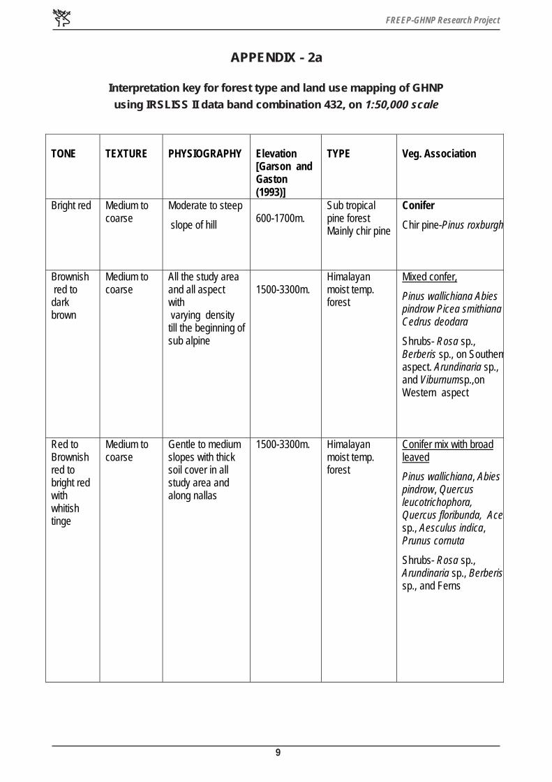
APPENDIX - 2a
Interpretation key for forest type and land use mapping of GHNP
using IRSLISS II data band combination 432, on 1:50,000 scale
TONE
TEXTURE
PHYSIOGRAPHY
Elevation [Garson and Gaston (1993)]
TYPE
Veg. Association
Bright red
Medium to coarse
Moderate to steep
slope of hill
600-1700m.
Sub tropical pine forest Mainly chir pine
Conifer
Chir pine-Pinus roxburghi
Brownish red to dark brown
Medium to coarse
All the study area and all aspect with varying density till the beginning of sub alpine
1500-3300m.
Himalayan moist temp. forest
Mixed confer,
Pinus wallichiana Abies pindrow Picea smithiana Cedrus deodara
Shrubs- Rosa sp., Berberis sp., on Southernaspect. Arundinaria sp., and Viburnumsp.,on Western aspect
Red to Brownish red to bright red with whitish tinge
Medium to coarse
Gentle to medium slopes with thick soil cover in all study area and along nallas
1500-3300m. Himalayan moist temp. forest
Conifer mix with broad leaved
Pinus wallichiana, Abies pindrow, Quercus leucotrichophora, Quercus floribunda, Acersp., Aesculus indica, Prunus cornuta
Shrubs- Rosa sp., Arundinaria sp., Berberis sp., and Ferns
Various Medium to Gentle to Medium Himalayan Broad leaved mix with

FREEP-GHNP Research Project
10
Various shades of Red to Brownish red
Medium to coarse
Gentle to Medium slopes and spurs on the ridges, soil cover sufficient
1500-3300m
Himalayan moist temp. forest
Broad leaved mix with Conifer
Upper storey- Quercus semecarpifolia, Betula utilis, Abies pindrow, Taxus bacata, Prunus cornuta, Acer sp.,
Under storey- Viburnum sp., Lonicera sp., Rosa sp., Arindinaria sp., etc.
Bright red to deep red
Medium to coarse
Along gentle to medium slopes, Moist containing areas, Along nalas and village surroundings
1500-3300m. Himalayan moist temp. forest
Broad leaved Upper storey- Quercus floribunda., Aesculus indica., Quercusleuchotrichophora., Betula alnoides., Q. semecarpifolia., Prunus.sp., Understorey- Rhododendron campanulatum., Bamboo braks, Viburnum sp., Berberis sp., Indigofera sp., Rosa sp., Sorbaria sp., and grasses
Light Red to Brownish red
Medium to coarse
Along river bed only in low elevated areas of park
Up to 2500m. Himalayan moist temp. forest
Aluns nitidula sp.,
Light pink with varying shades of greyish and brownish tinge
Medium to coarse
Higher to medium slopes and around villages also
1500-3300m. Himalayan moist temp. forest
Secondary scrub
Berberis chirita., Spirea sp., Indigofera sp., Rosa sp., Pinus wallichiana sp.,Abies sp., Acer sp., and grassess
FREEP-GHNP Research Project
11
Pinkish yellow green tinge
Fine to Medium
Top of the ridge portions, spurs and moist sloppy areas
Above 3000m to 3600m.
Sub-alpine and alpine zone
Dry alpine scrub
Rhododendron campanulatum, Juniper sp., Rohodendron lepidotum, Rohododendron anthopogon, with grassess, like Poa himalayana, Danthonia cachemyriana
Light red yellowish and green tinge
Fine to Medium
Generally all types of slope
1500-3600m. Temp., sub-alpine and alpine grass lands. (Have been Classified through GIS in a separate layer)
Grass lands Poa annua, Poa alpina, Agrostis, Danthonia cachemyriana
Various shades of Red to Brownish Red
Medium to coarse
Medium to Higher Slopes
1500-3300m. Temp. Zone Plantation
Plantation
Mainly Conifer :.Pinus wallichiana, Abies sp., Broad leaved :Acer sp., and grassess
Varying shades of yellowish green with red ting
Smooth to fine
Steep to moderate slope
1500-3600m. and above
Temp. , Sub-alpine and alpine zone
Exposed rock with slope grass.
Cliff
Alpine exposed rocks
Bluish to cyan colour
Smooth to fine
Steep to moderate and gentle slope
1500-3600m. and above
All the study area
Land slides
Bright to white and Light grey colour
Smooth to fine
Between river channels
Along the rivers Sand bar

FREEP-GHNP Research Project
12
Dark blue to dark brown
Smooth to fine
All the water bodies of study area,Mostly on higher elevated peneplain
Between 2000to 3000m.
specially on higher reaches
Water bodies
White to dirty white
Smooth to fine
Mostly on gentle to medium slope, specially North and North West aspect
Mostly above 3000m.
above snow line and also depend on slope and aspect
Snow
Grey to dirty grey and white
Medium to coarse
Mostly on medium to higher slope on upper reaches
Above 3600m.
Below/above snow line and confined within valley/undulated portions
Morrain
white Fine Mostly on upper reaches
Above 3600m.
Above morrains
Glacier
Dirty brown to grey
Medium to coarse
Mostly at middle and margins of morrain
Above 3600m.
After and within Morrain
Morrainic Ilands
Various tone of red with dark to light grey and pink
Medium to coarse
Medium to gentle slopes on south as well as South East Aspect
1300m-2500m
Mostly on moist temperate zone
Habitation/ Orchards/ Agriculture

FREEP-GHNP Research Project
13
APPENDIX - 3a
Classification Scheme for Visual Interpretation of Satllite Data
TYPE FOREST
SPECIES COMPOSITION SYMBOL
Conifer
Pinus roxburghii
1
Mixed Conifer
Pinus. wallichiana, Abies pindrow Picea smithiana., Cedrus deodar
2
Conifer and Broad
Leaved
P. wallichiana, Abies pindrow Quercus sp., Aesculus indica.,
Prunus sp.,
3
Broad Leaved and
Conifer
Quercus sp., Betula sp., Abies
sp., Taxus sp., Prunus sp.,
4
Broad Leaved
Quercus sp., Aesculus sp.,
Betula sp.,
5

FREEP-GHNP Research Project
14
TYPE FOREST
SPECIES COMPOSITION SYMBOL
Secondary scrub
Berberis chitra, Spirea sp., Indigofera sp., Rosa sp.,
6
Dry alpine scrub
Rhododendron sp., Junifer sp., Poa himalayana
7
Riverine
Alnus nitida dominated
8
Plantation
Cedrus deodara dominated
9
Grasslands of temp, sub alpine & alpine zone
Poa annua, Poa alpina etc
10
Grassland ( slope grasses)
Berberis, Indigofera, Desmodium Salix with slope grasses
11
APPENDIX - 3b
Classification Scheme for Visual Interpretation
of Satellite Data

FREEP-GHNP Research Project
15
TYPE
NON FOREST
SYMBOL
Cliffs 12
Rock outcrops 13
Landslides 14
Sand bar 15
River 16
Lakes 17
Morain 18
Moranic Islands 19
Glacier 20
Snow 21
Habitation/Orchards/Agriculture 22
APPENDIX - 3c
Classification Scheme for Visual Interpretation
of Satellite Data

FREEP-GHNP Research Project
16
AP
PE
ND
IX -
4a

FREEP-GHNP Research Project
17
APPENDIX - 5a
Aerial Estimation of Great Himalayan National Park Conservation Area
S.No Type Area in sq.km
1 Conifer ( Pinus roxburghii ) 2.08
2 Mixed conifer 127.98
3 Conifer and Broad Leaved Mixed 33.16
4 Broad Leaved 66.62
5 Broad Leaved and Conifer Mixed 83.36
6 Riperian .14
7 Slope Grasses 25.92
8 Grasslands/ Blanks
(Temp. sub Alpine & Alpine)
221.80
9 Secondary Scrub 22.28
10 Alpine Scrub 117.62
11 Plantation .16
12 Habitation/Agrculture/Orchards 25.55
13 Exp.Rocks with Slope Grasses 27.60
14 Alpine Exp. Rocks with Slope Grasses 149.73
15. River 4.35
16. Lakes .87
17. Escarpments 33.82
18. Landslide .41
19. Snow 184.01
20. Morian 24.24
21. Morainic Islands .48
22. Glaciers 18.82
Total 1171

FREEP-GHNP Research Project
18
AP
PE
ND
IX -
4b

FREEP-GHNP Research Project
19
APPENDIX - 5b
Aerial Estimation of Great Himalayan National Park Conservation Area -
Ecozone
S.No Type Area in sq.km
1 Conifer ( Pinus roxburghii ) 2.18
2 Mixed conifer 73.86
3 Conifer and Broad Leaved Mixed 10.63
4 Broad Leaved 30.10
5 Broad Leaved and Conifer Mixed 45.20
6 Riperian .14
7 Slope Grasses 16.50
8 Grasslands/ Blanks
(Temp. sub Alpine & Alpine)
7.23
9 Secondary Scrub 15.88
10 Alpine Scrub 6.08
11 Plantation .01
12 Habitation/Agrculture/Orchards 25.90
13 Exp.Rocks with Slope Grasses 8.28
14 Alpine Exp. Rocks with Slope Grasses .07
15. River 1.05
17. Escarpments 1.29
18. Landslide .08
Total 255

FREEP-GHNP Research Project
20
AP
PE
ND
IX -
4c
FREEP-GHNP Research Project
21
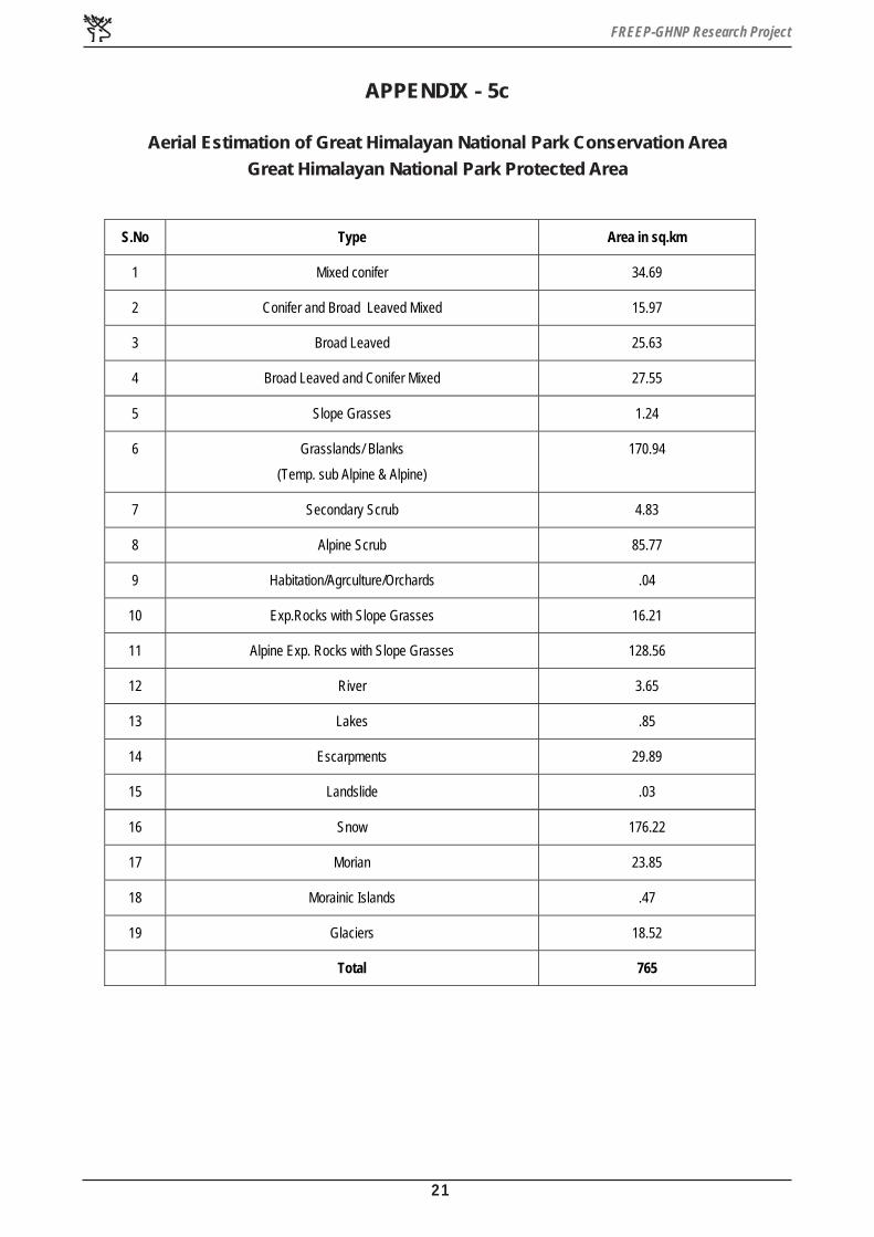
APPENDIX - 5c
Aerial Estimation of Great Himalayan National Park Conservation Area
Great Himalayan National Park Protected Area
S.No Type Area in sq.km
1 Mixed conifer 34.69
2 Conifer and Broad Leaved Mixed 15.97
3 Broad Leaved 25.63
4 Broad Leaved and Conifer Mixed 27.55
5 Slope Grasses 1.24
6 Grasslands/ Blanks
(Temp. sub Alpine & Alpine)
170.94
7 Secondary Scrub 4.83
8 Alpine Scrub 85.77
9 Habitation/Agrculture/Orchards .04
10 Exp.Rocks with Slope Grasses 16.21
11 Alpine Exp. Rocks with Slope Grasses 128.56
12 River 3.65
13 Lakes .85
14 Escarpments 29.89
15 Landslide .03
16 Snow 176.22
17 Morian 23.85
18 Morainic Islands .47
19 Glaciers 18.52
Total 765

FREEP-GHNP Research Project
22
AP
PE
ND
IX -
4d

FREEP-GHNP Research Project
23
APPENDIX - 5d
Aerial Estimation of Great Himalayan National Park Conservation Area Tirthan Wildlife
Sanctuary
S.No Type Area in sq.km
1 Mixed conifer 18.37
2 Conifer and Broad Leaved Mixed 5.51
3 Broad Leaved 4.66
4 Broad Leaved and Conifer Mixed 5.69
5 Grasslands/ Blanks
(Temp. sub Alpine & Alpine)
8.71
6 Secondary Scrub .02
7 Alpine Scrub 9.15
8 Habitation/Agrculture/Orchards .09
9 Exp.Rocks with Slope Grasses 1.29
10 Alpine Exp. Rocks with Slope Grasses 5.46
11 Escarpments 1.19
12 Snow .80
Total 61

FREEP-GHNP Research Project
24
AP
PE
ND
IX -
4e

FREEP-GHNP Research Project
25
APPENDIX - 5e
Aerial Estimation of Great Himalayan National Park Conservation Area
Sainj Wildlife Sanctuary
S.No Type Area in sq.km
1 Mixed conifer 3.51
2 Conifer and Broad Leaved Mixed 1.11
3 Broad Leaved 7.61
4 Broad Leaved and Conifer Mixed 5.65
5 Grasslands/ Blanks
(Temp. sub Alpine & Alpine)
32.57
6 Secondary Scrub 22.21
7 Alpine Scrub 15.67
8 Habitation/Agrculture/Orchards .37
9 Exp.Rocks with Slope Grasses 2.07
10 Alpine Exp. Rocks with Slope Grasses 13.62
11 River .16
12 Escarpments 1.00
13 Landslide .30
14 Snow 4.10
Total 90
FREEP-GHNP Research Project
26
AP
PE
ND
IX -
4f
FREEP-GHNP Research Project
27
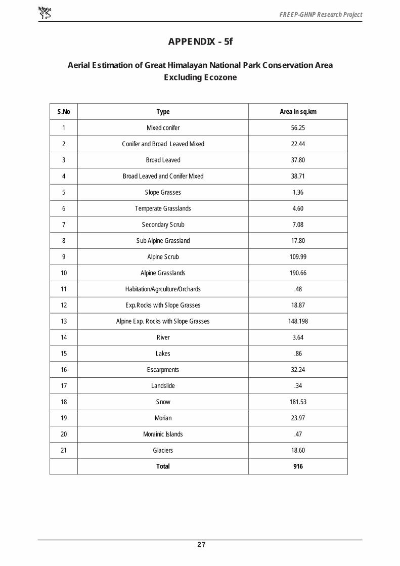
APPENDIX - 5f
Aerial Estimation of Great Himalayan National Park Conservation Area
Excluding Ecozone
S.No Type Area in sq.km
1 Mixed conifer 56.25
2 Conifer and Broad Leaved Mixed 22.44
3 Broad Leaved 37.80
4 Broad Leaved and Conifer Mixed 38.71
5 Slope Grasses 1.36
6 Temperate Grasslands 4.60
7 Secondary Scrub 7.08
8 Sub Alpine Grassland 17.80
9 Alpine Scrub 109.99
10 Alpine Grasslands 190.66
11 Habitation/Agrculture/Orchards .48
12 Exp.Rocks with Slope Grasses 18.87
13 Alpine Exp. Rocks with Slope Grasses 148.198
14 River 3.64
15 Lakes .86
16 Escarpments 32.24
17 Landslide .34
18 Snow 181.53
19 Morian 23.97
20 Morainic Islands .47
21 Glaciers 18.60
Total 916

FREEP-GHNP Research Project
28
AP
PE
ND
IX -
4g
FREEP-GHNP Research Project
29
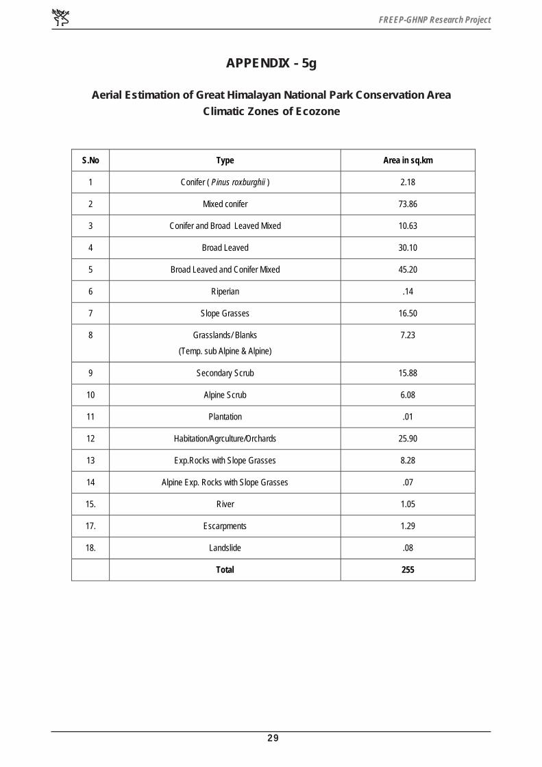
APPENDIX - 5g
Aerial Estimation of Great Himalayan National Park Conservation Area
Climatic Zones of Ecozone
S.No Type Area in sq.km
1 Conifer ( Pinus roxburghii ) 2.18
2 Mixed conifer 73.86
3 Conifer and Broad Leaved Mixed 10.63
4 Broad Leaved 30.10
5 Broad Leaved and Conifer Mixed 45.20
6 Riperian .14
7 Slope Grasses 16.50
8 Grasslands/ Blanks
(Temp. sub Alpine & Alpine)
7.23
9 Secondary Scrub 15.88
10 Alpine Scrub 6.08
11 Plantation .01
12 Habitation/Agrculture/Orchards 25.90
13 Exp.Rocks with Slope Grasses 8.28
14 Alpine Exp. Rocks with Slope Grasses .07
15. River 1.05
17. Escarpments 1.29
18. Landslide .08
Total 255

FREEP-GHNP Research Project
30
AP
PE
ND
IX -
4h

FREEP-GHNP Research Project
31
AP
PE
ND
IX -
4i

FREEP-GHNP Research Project
32
AP
PE
ND
IX -
4j

FREEP-GHNP Research Project
33
APPENDIX - 5h
Aerial Estimation of Great Himalayan National Park Conservation Area
Great Himalayan National Park Protected Area ( Cover Density )
S.No Type Area in sq.km
1 Close Forest 103.93
2 Open Forest 4.83
3 Slope Grasses 1.24
4 Grasslands/ Blanks
(Temp. sub Alpine & Alpine)
170.94
5 Alpine Scrub 85.77
6 Habitation/Agrculture/Orchards .04
7 Exp.Rocks with Slope Grasses 16.21
8 Alpine Exp. Rocks with Slope Grasses 128.56
9 River 3.65
10 Lakes .85
11 Escarpments 29.89
12 Landslide .03
13 Snow 176.22
14 Morian 23.85
15 Morainic Islands .47
16 Glaciers 18.52
Total 765
FREEP-GHNP Research Project
34
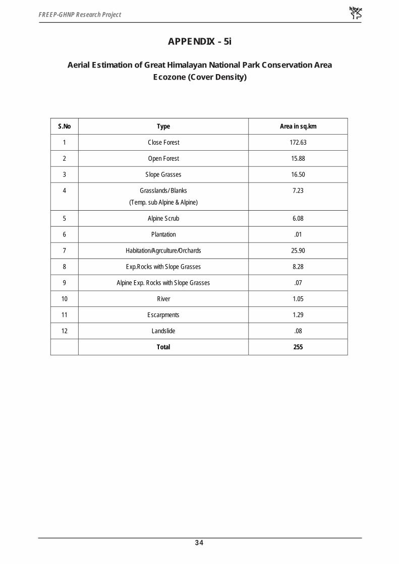
APPENDIX - 5i
Aerial Estimation of Great Himalayan National Park Conservation Area
Ecozone (Cover Density)
S.No Type Area in sq.km
1 Close Forest 172.63
2 Open Forest 15.88
3 Slope Grasses 16.50
4 Grasslands/ Blanks
(Temp. sub Alpine & Alpine)
7.23
5 Alpine Scrub 6.08
6 Plantation .01
7 Habitation/Agrculture/Orchards 25.90
8 Exp.Rocks with Slope Grasses 8.28
9 Alpine Exp. Rocks with Slope Grasses .07
10 River 1.05
11 Escarpments 1.29
12 Landslide .08
Total 255

FREEP-GHNP Research Project
35
APPENDIX - 5j
Aerial Estimation of Great Himalayan National Park Conservation Area
Climatic Zones
S.No Zone Area in sq.km
1 Above Snow Line 146.05
2 Cold Arid Zone 228.06
3 Alpine Zone 317.19
4 Sub Alpine Zone 143.25
5 Temperate Zone 92.63
6 Sub Tropical zone 244.20
FREEP-GHNP Research Project
36
APPENDIX - 6
Abstract
TEACHING MATERIAL FOR TRAINING WORKSHOP IN GHNP
By: SUNEET NAITHANI
RESEARCHER
Training of front line staff has been considered one of the most important activities aimed at
improving the management the protected areas. The coming workshop on training the front
line staff and foresters working in GHNP is likely to focus on improving more that one of the
many skills required for proper management and better enforcement of the park and wildlife
sanctuaries.
Skills of map reading and interpretation has an important role in the better management of
protected areas. It has been seen that more often that the concern staff is only acquainted
with the popular paths, river, flora and fauna but lacks knowledge overall geographical position/
location and diversity in various ecological system in protected areas.
It is proposed to provide the following skills to the front line staff of GHNP with special emphasis
on :
√ Interrelationship between Human, Forest, Water, Soil and Geography of the area, their
role and importance.
√ Map reading on 1:50,000 scale.
√ MATERIALS: SOI toposheets of the park on 1: 50,000
√ Slides of Snowbound area, Pastures, Forest, River terraces
√ (Agriculture-land), Landslides, Village/Social gathering.
√ Drawing pen, Board or large paper sheets.

FREEP-GHNP Research Project
37
APPENDIX - 7a
MONITORING APPROACH THROUGH REMOTE SENSING AND
GEOGRAPHICAL INFORMATION SYSTEM
IMPLEMENTATION
1: GIS facility within forest deptt.
2: Facility in SRSC
3: Facility in RRSC
4: Consultancy Mode/Project Mode
NOTE :
• SRSC : State Remote Sensing centre
• RRSC : Regional Remote Sensing Centre

FREEP-GHNP Research Project
38
APPENDIX - 7b
MAN DAYS REQUIRED FOR VEGETATION AND GRASSLANDS MAPPING THROUGH
REMOTE SENSING AND GEOGRAPHICAL INFORMATION SYSTEM
Monitoring : Project Mode/ Consultancy
A: Vegetation Mapping
Baseline data: Already available
DAYS NATURE OF WORK
7 Days Pre Interpretation.
15 Days Field work/ Ground Checking/Point
Sampling.
25 Days Map Preparation.
10 Days Field work for error estimation.
7 Days Final output.
B: Change Detection Analysis
20 Days Analysis on GIS Domain
Digitization,Editing,Topology
7 Days Change detection analysis
Total Man Days 90 ( Three Months )

FREEP-GHNP Research Project
39
APPENDIX - 7c
Tentative Expenditure in Consultancy/ Project Mode
For One Theme
One geocoded scene Rs. 11,000
Three persons for field work for 25 days Rs. 6,000/ - @ Rs. 80/day
Consultancy charges Rs. 30,000
Contingency Rs. 5,000
Travel Rs. 10,000
Use of GIS facility in SRSC/RRSC for a week in
regular 8 hours / day.
44,800/ - @ Rs. 800/hour for private users.
Reports/ Production coast 44,800
Miscellaneous 20,000
Total 1,41800
Note: About rate of consultancy charges NRSA Norms can be followed.
: Above price quoted are subjected to change depending on supplying/ resource agencies rates.


![FLOOD PROTECTION MEASURES OF THE SLOVAK REPUBLIC · 3RG]HPQêRGWRN 3Ð'$ 3RYUFKRYêRGWRN 1$6é7(1È ... Keep urbanized & industrial areas unchanged 2. Landcover / landuse types change](https://static.fdocuments.us/doc/165x107/5e8dcba5667b5a2e3315b5b7/flood-protection-measures-of-the-slovak-republic-3rghpqrgwrn-3-3ryufkryrgwrn.jpg)