LIST OF APPENDICES - Manitobacontent.gov.mb.ca/mit/hpd/pdf/project_p4/chapters/...environmental...
20
PROJECT 4 – ALL-SEASON ROAD ENVIRONMENTAL IMPACT STATEMENT Page 15-i TABLE OF CONTENTS Page 15.0 SUMMARY AND CONCLUSION ........................................................................................... 15-1 15.1 Summary ........................................................................................................................ 15-1 15.1.1 All-Season Road Network ................................................................................. 15-1 15.1.2 Proposed Project............................................................................................... 15-1 15.1.3 Environmental Setting ...................................................................................... 15-2 15.1.4 Engagement Program ....................................................................................... 15-3 15.1.5 Environmental Impact Assessment .................................................................. 15-3 15.1.6 Environmental Protection................................................................................. 15-3 15.2 Conclusion...................................................................................................................... 15-4 LIST OF APPENDICES Appendix 15-1: Environmental Impact Assessment Summary Table
Transcript of LIST OF APPENDICES - Manitobacontent.gov.mb.ca/mit/hpd/pdf/project_p4/chapters/...environmental...

PROJECT 4 – ALL-SEASON ROAD ENVIRONMENTAL IMPACT STATEMENT
Page 15-i
TABLE OF CONTENTS
Page
15.0 SUMMARY AND CONCLUSION ........................................................................................... 15-1
15.1 Summary ........................................................................................................................ 15-1
15.1.1 All-Season Road Network ................................................................................. 15-1
15.1.2 Proposed Project............................................................................................... 15-1
15.1.3 Environmental Setting ...................................................................................... 15-2
15.1.4 Engagement Program ....................................................................................... 15-3
15.1.5 Environmental Impact Assessment .................................................................. 15-3
15.1.6 Environmental Protection ................................................................................. 15-3
15.2 Conclusion ...................................................................................................................... 15-4
LIST OF APPENDICES
Appendix 15-1: Environmental Impact Assessment Summary Table

PROJECT 4 – ALL-SEASON ROAD ENVIRONMENTAL IMPACT STATEMENT
Page 15-1
15.0 SUMMARY AND CONCLUSION
15.1 Summary
15.1.1 All-Season Road Network
The East Side Road Authority (ESRA) is mandated to manage the East Side Transportation Initiative to
provide improved, safe and more reliable transportation service for the remote and isolated
communities on the east side of Lake Winnipeg. As part of the Large Area Transportation Network
Study, ESRA must design and construct an all-season road on provincial Crown land to connect Berens
River First Nation to Poplar River First Nation (the Project) and ensure that local communities participate
in, and benefit from, the Project. Construction and operation of the proposed 94.1 km two-lane gravel
all-season road requires federal and provincial regulatory approval.
In 2008, the Province commissioned a multi-disciplinary planning and engineering study to identify a
preferred network of all-season roads connecting communities on the east side of Lake Winnipeg. The
study, known as the Large Area Transportation Network Study, was completed in 2011 and set out to
assess the best route network of all-season roads, the likely scope of social and economic impacts and
benefits of the road network on local communities, potential environmental and cultural impacts and
construction and operations and maintenance cost estimates. Engagement with Aboriginal peoples on
the east side of Lake Winnipeg was a key element of the study and served as the initial formal “round”
of engagement with Berens River First Nation and Poplar River First Nation as well as other east side of
Lake Winnipeg communities.
Presently an all-season road from PR 304 to Berens River First Nation, also known as P1, is under
construction. Community economic development is occurring with over 300 participants receiving
construction-related training from ESRA and construction contracts awarded to Aboriginal companies.
Advancement of the Large Area Transportation Network Study recommendations is currently underway
with planning and design activities associated with the Berens River First Nation to Poplar River First
Nation all-season road segment that includes this EIS.
15.1.2 Proposed Project
As part of the Large Area Transportation Network Study described above, ESRA is proposing to construct
and maintain a 94.1 km two-lane gravel all-season road on provincial Crown Land on the east side of
Lake Winnipeg between Berens River First Nation and Poplar River First Nation. The main components
of the proposed Project are
Gravel-surface two-lane all-season road (94.1 km);
4 major water crossings (bridges) over the Berens, Etomami, North Etomami and Leaf rivers;
6 culvert crossings at fish-bearing watercourse crossings;
23 culverts at non-fish-bearing watercourse crossings;

PROJECT 4 – ALL-SEASON ROAD ENVIRONMENTAL IMPACT STATEMENT
Page 15-2
284 equalization culverts (estimated) to facilitate drainage/prevent flooding;
Approximately 3.5 km of temporary construction access routes;
Approximately 57 ha (0.57 km2) of temporary construction staging areas;
4 temporary construction camps covering approximately 64 ha (0.64 km2);
13 construction quarry sites;
Construction borrow areas; and
Facilities for the storage of explosives.
It is expected that this EIS for the proposed Project will be jointly reviewed by the federal and provincial
governments. Previously, projects that required a review under both federal and provincial
environmental assessment legislation were coordinated under the provisions of the Canada-Manitoba
Agreement on Environmental Assessment Cooperation (2007), which has since expired. Federally, the
construction and operation and maintenance of an all-season public highway that requires a total of 50
km or more of new right-of-way is considered a Designated Project under the Canadian Environmental
Assessment Act, 2012. The proposed P4 Project is, therefore, considered a Designated Project which
triggers the requirement for a federal environmental impact assessment (EIA) under the Act.
Provincially, the proposed P4 Project is considered a ‘Class 2’ development (i.e., a two lane road at a
new location with associated facilities and borrow pits) under the Classes of Development regulation of
The Environment Act of Manitoba and requires an Environment Act Licence which triggers the
requirement for a provincial environmental assessment. A 433-metre community access road on Poplar
River First Nation Reserve lands is proposed and will follow a separate environmental review process
conducted by Indigenous and Northern Affairs Canada per the requirements of the Canadian
Environmental Assessment Act, 2012. ESRA will also apply for required construction permits under the
Indian Act.
15.1.3 Environmental Setting
The proposed all-season road Project is located on the east side of Lake Winnipeg in a remote and
largely unsettled and undeveloped area of the Province. The proposed Project is located on the east
side of Lake Winnipeg within the Lac Seul Upland Ecoregion of the Boreal Shield Ecozone. The landscape
is generally characterized by flat, low-lying and poorly-drained land with forest patches of black spruce
and tamarack interspersed with bogs and fens. Surface waters flow west to Lake Winnipeg then north
to Hudson Bay. Mammal, bird, fish and herptile species, including some of conservation concern such as
the boreal woodland caribou, inhabit the area. The communities of Berens River First Nation/Northern
Affairs Community and Poplar River First Nation are the only human settlements in the Local
Assessment Area and are connected by winter road to the southern road network for a brief period each
year. Transportation to and from these communities is otherwise primarily by aircraft. Land use in the
Local Assessment Area is mainly traditional activities by local community members such as hunting,
trapping, fishing, camping, timber harvest for firewood, recreation activities, sacred/ceremonial uses
and food and medicine gathering.

PROJECT 4 – ALL-SEASON ROAD ENVIRONMENTAL IMPACT STATEMENT
Page 15-3
15.1.4 Engagement Program
An Aboriginal and Public Engagement Program (APEP) was undertaken to provide meaningful
opportunities to engage in dialogue and exchange information about the proposed Project and other
proposed transportation initiatives on the east side of the Lake. Engagement activities were focused on
interaction with and feedback from potentially interested and affected communities and community
members, as well as the general public. The engagement program comprised face-to-face meetings or
discussions with First Nation and Métis leadership, community members, regulators, trappers, outfitters
and members of the general public.
15.1.5 Environmental Impact Assessment
An environmental impact assessment of the Project was completed using a values-based framework
through the consideration of linkages between Valued Components of the environment and anticipated
Project activities. Information provided through the engagement program, workshops, published
literature, baseline studies and professional perspective was relied upon for the impact assessment.
Mitigation measures and procedures for their effective implementation were identified from regulatory
and industry standards, environmental guidance documents and ESRA-developed environmental
protection specifications to avoid, minimize or offset potential adverse environmental effects of the
Project. The effects of accidents and malfunctions and potential effects of the environment on the
Project were also assessed, as were sustainability, climate change and cumulative effects. Follow-up
actions, such as construction and post-construction monitoring programs, were identified where
required by legislation and/or guidance documents, and to address uncertainty arising in the
identification of environmental effects or the ability to mitigate those effects. Residual environmental
effects were evaluated based on a significance evaluation framework developed by ESRA. An
environmental assessment summary table is provided in Appendix 15-1.
15.1.6 Environmental Protection
ESRA is committed to implementing a broad suite of mitigation measures and follow-up actions
identified by the environmental impact assessment through ESRA’s comprehensive Environmental
Program. The Environmental Program incorporates ESRA’s environmental protection specifications
(GR130s) and identifies Project-specific environmental protection guidelines and requirements directly
in construction contract documents. Construction contractors will be responsible for the preparation
and implementation of environmental protection plans, health and safety plans, emergency response
plan, erosion and sediment control plans, hazardous materials management plans, and the completion
of applicable monitoring programs. As the Project proponent, ESRA will be responsible for
implementing, inspecting and reporting on this program through the construction and operations and
maintenance phases of the Project.

PROJECT 4 – ALL-SEASON ROAD ENVIRONMENTAL IMPACT STATEMENT
Page 15-4
15.2 Conclusion
Based on the information and analysis provided in this Environmental Impact Statement, it is concluded
that the proposed all-season road connecting Berens River First Nation and Poplar River First Nation is
not likely to cause significant adverse environmental effects. The Environmental Impact Statement also
concludes that Project benefits (i.e., positive effects such as training, employment and business
opportunities) can be expected.

PROJECT 4 – ALL-SEASON ROAD ENVIRONMENTAL IMPACT STATEMENT
Page 15-1
CHAPTER 15 APPENDICES

PROJECT 4 – ALL-SEASON ROAD ENVIRONMENTAL IMPACT STATEMENT
Appendix 15-1
Environmental Impact Assessment
Summary Table

PROJECT 4 – ALL-SEASON ROAD ENVIRONMENTAL IMPACT STATEMENT
Appendix 15-1 Page 2
Appendix 15-1: Environmental Impact Assessment Summary Table
Valued Component
Affected
Area of Federal
Jurisdiction (Section 5 of CEAA, 2012)*
Project Activity Potential Effects Proposed Mitigation Adverse Residual Effect
Level Ratings of Residual Effects
(I = low; II = moderate; III = high)** Significance of Residual
Adverse Effect
Du
rati
on
Mag
nit
ud
e
Exte
nt
Fre
qu
en
cy
Re
vers
ibili
ty
Eco
logi
cal
Co
nte
xt
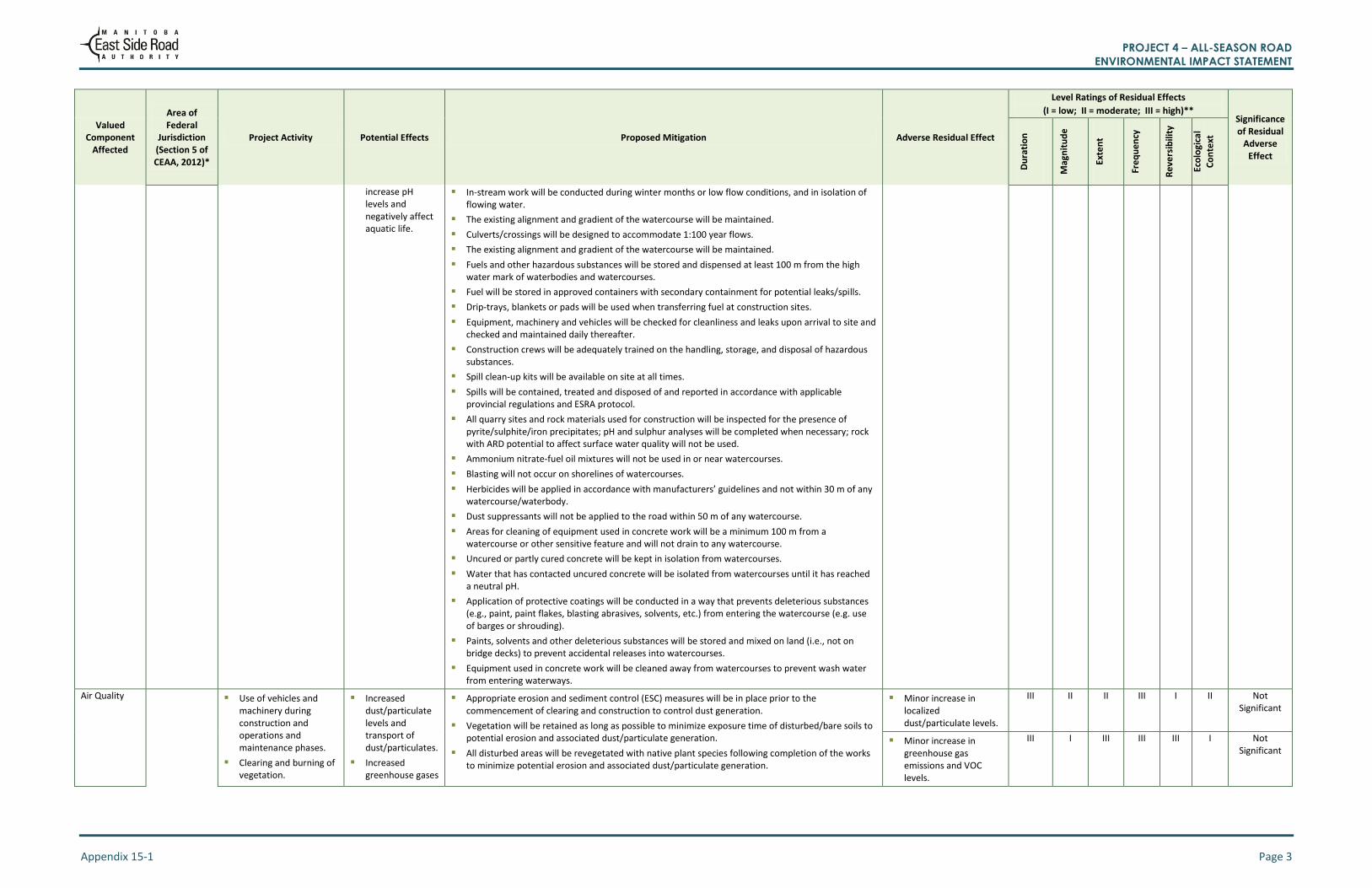
Physical Environment
Surface Water
Construction of the all-season road including vegetation clearing, establishment and use of quarries, borrow areas, temporary access routes and construction and installation of bridges and culverts.
Equipment, vehicle and machinery use, including blasting activities.
The use of cast in place concrete.
Alteration of surface drainage patterns in the Local Assessment Area.
Alteration of stream flow at watercourse crossing locations.
Alteration of ice freeze-up/break-up dynamics at watercourse crossings.
Temporary increase in suspended sediments and debris into watercourses in the Local Assessment area.
Impaired surface water quality in the Local Assessment Area due to introduction of hazardous substances.
Release of alkaline concrete or concrete wash water that can
Appropriately designed watercourse crossing structures and appropriately designed, number and placement of equalization culverts will be installed to preserve existing surface water drainage patterns to the extent feasible.
Where possible, roads and construction activities will be a minimum of 100 m from waterbodies except when crossing a watercourse.
Where a 100 m distance is not possible, a buffer zone of undisturbed vegetation between the construction activities and the watercourse will be established. The buffer zone width will be established according to the following formula: Width = 10 m + (1.5 X slope gradient) or 30 m whichever is greater.
Clearing within 30 m of a watercourse will be completed by hand.
Clearing near watercourses will be temporarily suspended during very wet or muddy conditions.
Vegetation will be retained as long as possible to minimize the exposure time of disturbed/bare soils to potential erosion.
Clearing limits will be clearly marked prior to riparian vegetation removal to avoid unnecessary damage to or removal of vegetation.
Slash or debris piles will be stabilized and stored above the high water mark until disposal.
Overburden will be adequately stabilized and stored above the high water mark.
In-stream work will be conducted during winter months or low flow conditions, and in isolation of flowing water (e.g., with the use of cofferdams, channel diversions, silt curtains) to mitigate downstream sediment transfer.
Silt curtains will be installed downstream of in-water work, if appropriate
Appropriate erosion and sediment control (ESC) measures will be in place prior to the commencement of clearing and construction.
ESC measures will be regularly inspected and maintained to confirm effectiveness throughout construction.
Disturbed areas will be stabilized through revegetation with native plant species or other appropriate means (e.g., erosion control blankets) following completion of the works.
ESC measures will remain in place until disturbed areas are stabilized and revegetated.
Surface water drainage will be directed along the road or around cleared areas and away from watercourses.
Vegetation clearing will be limited to the extent feasible to minimize the potential for soil erosion; within the right-of-way, vegetation clearing will be limited to the removal of trees and tall shrubs (to maintain line of sight safety requirements) with no removal of low growing vegetation.
Minor alteration of surface drainage and stream flow at watercourse crossings.
III I I I I I Not Significant
Minor alteration of ice dynamics at watercourse crossings.
III I I II I I Not Significant
PROJECT 4 – ALL-SEASON ROAD ENVIRONMENTAL IMPACT STATEMENT
Appendix 15-1 Page 3
Valued Component
Affected
Area of Federal
Jurisdiction (Section 5 of CEAA, 2012)*
Project Activity Potential Effects Proposed Mitigation Adverse Residual Effect
Level Ratings of Residual Effects
(I = low; II = moderate; III = high)** Significance of Residual
Adverse Effect
Du
rati
on
Mag
nit
ud
e
Exte
nt
Fre
qu
en
cy
Re
vers
ibili
ty
Eco
logi
cal
Co
nte
xt
increase pH levels and negatively affect aquatic life.
In-stream work will be conducted during winter months or low flow conditions, and in isolation of flowing water.
The existing alignment and gradient of the watercourse will be maintained.
Culverts/crossings will be designed to accommodate 1:100 year flows.
The existing alignment and gradient of the watercourse will be maintained.
Fuels and other hazardous substances will be stored and dispensed at least 100 m from the high water mark of waterbodies and watercourses.
Fuel will be stored in approved containers with secondary containment for potential leaks/spills.
Drip-trays, blankets or pads will be used when transferring fuel at construction sites.
Equipment, machinery and vehicles will be checked for cleanliness and leaks upon arrival to site and checked and maintained daily thereafter.
Construction crews will be adequately trained on the handling, storage, and disposal of hazardous substances.
Spill clean-up kits will be available on site at all times.
Spills will be contained, treated and disposed of and reported in accordance with applicable provincial regulations and ESRA protocol.
All quarry sites and rock materials used for construction will be inspected for the presence of pyrite/sulphite/iron precipitates; pH and sulphur analyses will be completed when necessary; rock with ARD potential to affect surface water quality will not be used.
Ammonium nitrate-fuel oil mixtures will not be used in or near watercourses.
Blasting will not occur on shorelines of watercourses.
Herbicides will be applied in accordance with manufacturers’ guidelines and not within 30 m of any watercourse/waterbody.
Dust suppressants will not be applied to the road within 50 m of any watercourse.
Areas for cleaning of equipment used in concrete work will be a minimum 100 m from a watercourse or other sensitive feature and will not drain to any watercourse.
Uncured or partly cured concrete will be kept in isolation from watercourses.
Water that has contacted uncured concrete will be isolated from watercourses until it has reached a neutral pH.
Application of protective coatings will be conducted in a way that prevents deleterious substances (e.g., paint, paint flakes, blasting abrasives, solvents, etc.) from entering the watercourse (e.g. use of barges or shrouding).
Paints, solvents and other deleterious substances will be stored and mixed on land (i.e., not on bridge decks) to prevent accidental releases into watercourses.
Equipment used in concrete work will be cleaned away from watercourses to prevent wash water from entering waterways.
Air Quality
Use of vehicles and machinery during construction and operations and maintenance phases.
Clearing and burning of vegetation.
Increased dust/particulate levels and transport of dust/particulates.
Increased greenhouse gases
Appropriate erosion and sediment control (ESC) measures will be in place prior to the commencement of clearing and construction to control dust generation.
Vegetation will be retained as long as possible to minimize exposure time of disturbed/bare soils to potential erosion and associated dust/particulate generation.
All disturbed areas will be revegetated with native plant species following completion of the works to minimize potential erosion and associated dust/particulate generation.
Minor increase in localized dust/particulate levels.
III II II III I II Not Significant
Minor increase in greenhouse gas emissions and VOC levels.
III I III III III I Not Significant

PROJECT 4 – ALL-SEASON ROAD ENVIRONMENTAL IMPACT STATEMENT
Appendix 15-1 Page 4
Valued Component
Affected
Area of Federal
Jurisdiction (Section 5 of CEAA, 2012)*
Project Activity Potential Effects Proposed Mitigation Adverse Residual Effect
Level Ratings of Residual Effects
(I = low; II = moderate; III = high)** Significance of Residual
Adverse Effect
Du
rati
on
Mag
nit
ud
e
Exte
nt
Fre
qu
en
cy
Re
vers
ibili
ty
Eco
logi
cal
Co
nte
xt
Blasting activities. and VOCs.
Reduction of carbon sink with removal of vegetation for the Project Footprint.
Water and other approved suppressants will be used to control dust as required.
Quarries, borrow areas and other temporary construction components (e.g., laydown areas) will be located as close to the road corridor as feasible to limit distance travelled by construction vehicles.
Idling time of equipment and vehicles will be restricted.
Routine maintenance of construction equipment and vehicles will be undertaken.
Proper storage and handling of fuels and other VOC-generating construction supplies.
Clearing will be limited to the extent required to construct Project components.
Communities will be contacted to identify opportunities for salvaging timber for alternate use to burning.
Burning will normally occur between November 16 and March 31 in accordance with permit requirements.
Work having the potential to create dust , particulate debris or smoke (e.g., debris burning, blasting) will not take place during high wind conditions
Explosive materials will be stored, handled and used according to applicable regulations and guidelines .
Explosives will be detonated at sufficient setback distances to control for dust/debris expulsion.
Minor loss of carbon sink.
III I III I II I Not Significant
Noise Use of vehicles and machinery during construction and operations and maintenance phases.
Blasting activities.
Increased noise and vibration.
Vehicles, machinery and equipment will be fitted with factory-installed noise-reducing components (e.g. mufflers, acoustic linings, shields), where possible, and will be maintained to minimize excessive noise.
Explosives will be detonated at sufficient distances from communities (i.e., First Nation reserves) to minimize noise/vibration effects.
Industry best practices (e.g., blasting plans, blasting mats, appropriate charging procedures) will be used for blasting activities.
Where possible, undisturbed forested buffers will be retained around quarries to reduce noise from quarry operations.
Scheduling of blasting will occur when in the vicinity of sensitive wildlife sites.
Blasting will not occur during high wind conditions.
Temporary sensory disturbance to local communities/
people due to noise and/or vibrations.
I I II III I I Not Significant
Fish Habitat, Fish and Harvested Fish, and Aquatic Species at Risk
Construction and operations and maintenance of bridges and culverts.
Permanent alteration or destruction of instream and riparian zone habitat.
Instream construction activities conducted in fish bearing watercourses will be timed to avoid fish spawning and incubation periods in spring (April 1-June 15), summer (May 1-June 30), and fall (September 15 to April 30).
Instream construction will be conducted in isolation from flowing water to mitigate downstream sediment transfer, e.g., with the use of cofferdams, channel diversions, silt curtains.
A fish salvage will be conducted within the isolated work area of fish-bearing watercourses prior to the commencement of instream work.
Riparian vegetation clearing within the right-of-way will be limited to the removal of trees and tall shrubs (to maintain line of sight safety requirements) with no removal of low growing vegetation beyond the road surface and shoulder.
Clearing within 30 m of a watercourse shall be by hand.
Clearing limits will be clearly marked prior to riparian vegetation removal to avoid unnecessary damage to or removal of vegetation.
Disturbed areas will be stabilized through revegetation with native plant species or other appropriate means (e.g., erosion control blankets) following completion of the works.
Permanent destruction of 206.5 m
2 of instream
habitat and 180 m of riparian zone habitat.
III I I I III I Not Significant

PROJECT 4 – ALL-SEASON ROAD ENVIRONMENTAL IMPACT STATEMENT
Appendix 15-1 Page 5
Valued Component
Affected
Area of Federal
Jurisdiction (Section 5 of CEAA, 2012)*
Project Activity Potential Effects Proposed Mitigation Adverse Residual Effect
Level Ratings of Residual Effects
(I = low; II = moderate; III = high)** Significance of Residual
Adverse Effect
Du
rati
on
Mag
nit
ud
e
Exte
nt
Fre
qu
en
cy
Re
vers
ibili
ty
Eco
logi
cal
Co
nte
xt
Vegetation Communities and Plant Species of Cultural Importance
Clearing of vegetation.
Introduction and spread of non-native and invasive species in the Local Assessment Area during Project construction and operations and maintenance.
Loss or impairment of vegetation communities and/or plant species of cultural importance in the Project Footprint.
Minimal risk for the introduction and spread of non-native and invasive species.
Limiting vegetation clearing to designated areas within the Project Footprint.
Conducting clearing and construction activities during winter months to the extent feasible.
Cleaning construction equipment and vehicles prior to bringing them into the construction area.
Using granular materials obtained on-site or using a nearby local quarry.
Restoring ground cover vegetation using natural means, augmented with planting and seeding of native plants, as required.
Routing the all-season road and selecting Project component locations that avoid important areas of botanical resources.
Further assessing the two Arethusas (S2) specimens found within the Project Footprint and making efforts to protect them based on site-specific conditions
Loss or impairment of vegetation communities or Plants Species of Special Interest in the Project Footprint.
III II I I III I Not Significant
Introduction and spread of non-native and invasive species in the Project Footprint during construction phase.
II I I II II I Not Significant
Introduction and spread of non-native and invasive species in the Project Footprint or Local Assessment Area during operations and maintenance phase.
III I II II II I Not Significant
Ungulates (Moose and Boreal Woodland Caribou)
Construction activities: vegetation clearing; road construction and installation of bridges and culverts; set-up and use of equipment, crews, temporary staging areas, temporary work camps; set-up and use of borrow and quarry areas; development of temporary routes and trails.
Operations and maintenance activities: road maintenance; snow clearing; right-of-way vegetation management; bridge and culvert maintenance; debris removal; structural repairs.
Habitat disturbance, alteration or fragmentation.
Temporary sensory disturbance.
Increased mortality due to vehicle collisions.
Increased mortality or changes in distribution due to changes in hunting access.
Increased mortality or changes in distribution due to changes in predation.
Introduction of disease / parasitism (i.e., brainworm [P. tenius] from white-tailed deer)
Design mitigation measures (e.g., two-lanes; designed to optimize line of sight; no pull-outs or parking areas).
Routing all-season road to avoid areas of high quality habitat where feasible.
Limiting riparian vegetation clearing within the right of way to the removal of trees and tall shrubs (to maintain line of sight safety requirements).
Clearing during fall and winter to the extent feasible to avoid parturition times for moose.
Maintaining existing water flow patterns, levels and wetland hydrologic regimes.
Staging construction as required, i.e., stop and delay construction activities in sensitive areas until animal use of the area and/or sensitive time period has passed.
Using existing access routes, trails, or cut lines to the extent feasible and access routes and trails will be kept as short and narrow as feasible.
Decommissioning winter roads, temporary access routes and trails as soon as feasible to allow the regeneration of vegetation.
Decommissioning winter roads, temporary access routes and trails to block off/limit human access.
Identifying mineral licks and including them in Environmental Protection Plans as Environmentally Sensitive Sites.
Limiting construction and operations/maintenance to work areas within the Project Footprint.
Applying dust suppression techniques as per ESRA’s GR130s and Environmental Protection Procedures.
Installing wildlife crossing and/or speed reduction signs where necessary to reduce the potential of wildlife-vehicle collisions.
Suspending quarry blasting and other construction activities during spring months near known calving areas.
Loss, alteration or fragmentation of habitat.
I moose
III caribou
II I
I III I Not Significant
Temporary sensory disturbance (during construction).
I II I II I I Not Significant
Temporary sensory disturbance (during operations and maintenance).
III II I II I I Not Significant

PROJECT 4 – ALL-SEASON ROAD ENVIRONMENTAL IMPACT STATEMENT
Appendix 15-1 Page 6
Valued Component
Affected
Area of Federal
Jurisdiction (Section 5 of CEAA, 2012)*
Project Activity Potential Effects Proposed Mitigation Adverse Residual Effect
Level Ratings of Residual Effects
(I = low; II = moderate; III = high)** Significance of Residual
Adverse Effect
Du
rati
on
Mag
nit
ud
e
Exte
nt
Fre
qu
en
cy
Re
vers
ibili
ty
Eco
logi
cal
Co
nte
xt
Aquatic Furbearers (Beaver)
Construction activities: vegetation clearing; road construction and installation of bridges and culverts; set-up and use of equipment, crews, temporary staging areas, temporary work camps; set-up and use of borrow and quarry areas; development of temporary routes and trails.
Operations and maintenance activities: road maintenance; snow clearing; right-of-way vegetation management; bridge and culvert maintenance; debris removal; structural repairs.
Habitat loss, alteration or fragmentation.
Temporary sensory disturbance.
Design mitigation measures (e.g., two-lanes; designed to optimize line of sight; no pull-outs or parking areas).
All-season road routing avoided areas of high quality habitat such as lakes, ponds and wetlands where feasible.
Existing water flow patterns, levels and wetland hydrologic regimes will be maintained through road design.
Riparian vegetation clearing within the right-of-way will be limited to the removal of trees and tall shrubs (to maintain line of sight safety requirements) with no removal of low growing vegetation.
A vegetated buffer zone will be retained between the all-season road and lakes or ponds along the right-of-way, e.g., Bull Lake and Pamatakakowin Lake.
Where feasible, roads will be located a minimum of 100 m from waterbodies except when crossing a watercourse.
Appropriate erosion and sediment control (ESC) measures will be in place prior to the commencement of clearing and construction and will remain in place until disturbed areas are stabilized and revegetation is occurring.
Limiting construction and operations and maintenance to work areas within the Project Footprint.
Habitat loss, alteration or fragmentation.
III I I I III I Not Significant
Temporary sensory disturbance.
III II I II I I Not Significant
Terrestrial Furbearers (Marten)
Construction activities: vegetation clearing; road construction and installation of bridges and culverts; set-up and use of equipment, crews, temporary staging areas, temporary work camps; set-up and use of borrow and quarry areas; development of temporary routes and trails.
Operations and maintenance activities: road maintenance; snow clearing; right-of-way vegetation management; bridge and culvert maintenance; debris removal; structural repairs.
Habitat loss, alteration or fragmentation.
Temporary sensory disturbance.
Design mitigation measures (e.g., two-lanes; designed to optimize line of sight; no pull-outs or parking areas).
Construction and operations/maintenance activities will be localized to work areas within the Project Footprint.
Road clearing activities will occur during daytime hours when marten are less active.
Dens found during pre-construction surveys will be marked and isolated as Sensitive Sites.
Applying dust suppression techniques as per ESRA’s GR130s and Environmental Protection Procedures.
Road, bridge and culvert maintenance activities will be timed to occur during fall and winter to the extent feasible to reduce potential effects on marten during natal or maternal denning periods.
Habitat loss, alteration or fragmentation.
III I I I III I Not Significant
Temporary sensory disturbance.
III II I II I I Not Significant

PROJECT 4 – ALL-SEASON ROAD ENVIRONMENTAL IMPACT STATEMENT
Appendix 15-1 Page 7
Valued Component
Affected
Area of Federal
Jurisdiction (Section 5 of CEAA, 2012)*
Project Activity Potential Effects Proposed Mitigation Adverse Residual Effect
Level Ratings of Residual Effects
(I = low; II = moderate; III = high)** Significance of Residual
Adverse Effect
Du
rati
on
Mag
nit
ud
e
Exte
nt
Fre
qu
en
cy
Re
vers
ibili
ty
Eco
logi
cal
Co
nte
xt
Migratory Birds: Forest Birds
Construction activities: vegetation clearing; road construction and installation of bridges and culverts; set-up and use of equipment, crews, temporary staging areas, temporary work camps; set-up and use of borrow and quarry areas; development of temporary routes and trails.
Operations and maintenance activities: road maintenance; snow clearing; right-of-way vegetation management; bridge and culvert maintenance; debris removal; structural repairs.
Habitat loss, alteration, fragmentation.
Temporary sensory disturbance.
Project routing and siting to avoid sensitive areas and high quality habitats to the greatest extent feasible.
Activities timed to occur during fall and winter where feasible to avoid nesting periods.
Activities limited to work areas within the Project Footprint.
Applying dust suppression techniques as per ESRA’s GR130s and Environmental Protection Procedures.
Rehabilitation of trails and winter roads to offset habitat loss.
Conduct pre-clearing migratory bird nest surveys during the nesting season. If found, they will be marked and isolated as Environmentally Sensitive Sites and setbacks from construction activities will be implemented to the greatest extent feasible.
Reclaim disturbed areas and encourage natural regrowth, e.g., temporary access routes, winter roads and trails will be decommissioned as soon as feasible to allow the regeneration of vegetation.
Additional mitigation measures for bird species at risk (Appendix 9-7, Table 9.7b) may also be applied where appropriate.
Habitat loss, alteration, fragmentation.
III I I I II I Not Significant
Temporary sensory disturbance.
III II I II I I Not Significant
Migratory Birds: Waterbirds
Construction activities: vegetation clearing; road construction and installation of bridges and culverts; set-up and use of equipment, crews, temporary staging areas, temporary work camps; set-up and use of borrow and quarry areas; development of temporary routes and trails.
Operations and maintenance activities: road maintenance; snow clearing; right-of-way vegetation management; bridge and culvert maintenance; debris removal; structural repairs.
Habitat loss, alteration, fragmentation.
Temporary sensory disturbance.
Project routing and siting to avoid sensitive areas and high quality habitats to the extent feasible.
Rehabilitation of trails and winter roads to offset habitat loss.
Conduct pre-clearing migratory bird nest surveys during the nesting season. If found, they will be marked and isolated as Environmentally Sensitive Sites and setbacks from construction activities will be implemented to the extent feasible.
A vegetated buffer zone will be retained between the all-season road and lakes or ponds along the right-of-way, e.g., Bull Lake and Pamatakakowin Lake.
Activities timed to occur during fall and winter where feasible to avoid nesting periods.
Activities limited to work areas within the Project Footprint.
Applying dust suppression techniques as per ESRA’s GR130s and Environmental Protection Procedures.
Existing water flow patterns, water levels and wetland hydrologic regimes will be maintained.
Reclaim disturbed areas and encourage natural regrowth, e.g., temporary access routes, winter roads and trails will be decommissioned as soon as feasible to allow the regeneration of vegetation.
Additional mitigation measures for waterbird species at risk (Appendix 9-7, Table 9.7b) may also be applied where appropriate.
Habitat loss, alteration, fragmentation.
III I I I II I Not Significant
Temporary sensory disturbance.
III II I II I I Not Significant

PROJECT 4 – ALL-SEASON ROAD ENVIRONMENTAL IMPACT STATEMENT
Appendix 15-1 Page 8
Valued Component
Affected
Area of Federal
Jurisdiction (Section 5 of CEAA, 2012)*
Project Activity Potential Effects Proposed Mitigation Adverse Residual Effect
Level Ratings of Residual Effects
(I = low; II = moderate; III = high)** Significance of Residual
Adverse Effect
Du
rati
on
Mag
nit
ud
e
Exte
nt
Fre
qu
en
cy
Re
vers
ibili
ty
Eco
logi
cal
Co
nte
xt
Environment-ally Sensitive Wildlife Sites
Construction activities: vegetation clearing; road construction and installation of bridges and culverts; set-up and use of equipment, crews, temporary staging areas, temporary work camps; set-up and use of borrow and quarry areas; development of temporary routes and trails.
Operations and maintenance activities: road maintenance; snow clearing; right-of-way vegetation management; bridge and culvert maintenance; debris removal; structural repairs.
Loss, alteration or physical disturbance of overwintering dens, heron rookeries, hibernacula, large stick nests or mineral licks.
Temporary sensory disturbance.
Design mitigation measures (e.g., two-lanes; designed to optimize line of sight; no pull-outs or parking areas).
Mineral licks have been identified and included in Environmental Protection Procedures as Environmentally Sensitive Sites.
Dens, heron rookeries, hibernacula, large stick nests or additional mineral licks found during pre-construction surveys will be marked and isolated as Environmentally Sensitive Sites in the Environmental Protection Procedures.
In the event that dens, heron rookeries, hibernacula, large stick nests or additional mineral licks are found during construction or maintenance activities, these areas will be marked and isolated as Environmentally Sensitive Sites; setbacks from construction and operations and maintenance activities and/or staged construction and operations and maintenance activities, (i.e., stop and delay construction or operations and maintenance activities in sensitive areas until animal use of the area and/or sensitive time period has passed) will be implemented to the extent feasible.
Existing access routes, trails, or cut lines will be used to the extent feasible and access routes and trails will be kept as short and narrow as feasible.
Construction and operations and maintenance activities will be localized to work areas within the Project Footprint.
Loss, alteration or physical disturbance of overwintering dens, heron rookeries, hibernacula, large stick nests or mineral licks.
I I I I III I Not Significant
Temporary sensory disturbance.
III II I II I I Not Significant
Herptiles Construction activities: vegetation clearing; road construction and installation of bridges and culverts; set-up and use of equipment, crews, temporary staging areas, temporary work camps; set-up and use of borrow and quarry areas; development of temporary routes and trails.
Operations and maintenance activities: road maintenance; snow clearing; right-of-way vegetation management; bridge and culvert maintenance; debris removal; structural repairs.
Temporary sensory disturbance during construction and maintenance activities located near waterbody or bog and fen areas having suitable habitat.
Increased mortality due to vehicle collisions.
Loss or alteration of breeding or feeding habitat due to construction or operation activities located near waterbody or bog/fen areas having suitable habitat.
Design mitigation measures (e.g., two-lanes; designed to optimize line of sight; no pull-outs or parking areas.
Implementation of a vegetated buffer zone between lakes, ponds and bog/fen areas, and the road construction and operation activities.
Application of dust suppression techniques as per ESRA’s GR130s and Environmental Protection Procedures.
Clearing activities will occur during late fall and winter to the extent feasible to avoid herptile breeding, emergence (e.g., hatchling) periods and movements.
Information about wildlife awareness will be provided for road construction workers and local residents to reduce vehicle speeds and the risk of wildlife-vehicle collisions.
The installation of culverts along the all-season road will provide alternate routes for passage under the roadway by herptiles and other wildlife.
All-season road routing avoided areas of high quality habitat such as lakes, ponds and bog/fen where feasible.
Existing water flow patterns, levels and bog/fen hydrologic regimes will be maintained.
A vegetated buffer zone will be retained between the all-season road and lakes or ponds along the right-of-way, e.g., Bull Lake and Pamatakakowin Lake.
Where feasible, roads will be located a minimum of 100 m from waterbodies except when crossing a watercourse.
The implementation of vegetated buffer zones around identified Environmentally Sensitive Sites will help to mitigate potential effects on herptiles.
Additional mitigation measures for herptile species at risk (Appendix 9-7, Table 9.7b) may also be applied where appropriate.
Increased mortality due to vehicle collisions (construction phase).
I I I II III I Not Significant
Increased mortality due to vehicle collisions (operations and maintenance phase).
III I I II III I Not Significant
Temporary sensory disturbance.
III II I II I I Not Significant
PROJECT 4 – ALL-SEASON ROAD ENVIRONMENTAL IMPACT STATEMENT
Appendix 15-1 Page 9
Valued Component
Affected
Area of Federal
Jurisdiction (Section 5 of CEAA, 2012)*
Project Activity Potential Effects Proposed Mitigation Adverse Residual Effect
Level Ratings of Residual Effects
(I = low; II = moderate; III = high)** Significance of Residual
Adverse Effect
Du
rati
on
Mag
nit
ud
e
Exte
nt
Fre
qu
en
cy
Re
vers
ibili
ty
Eco
logi
cal
Co
nte
xt
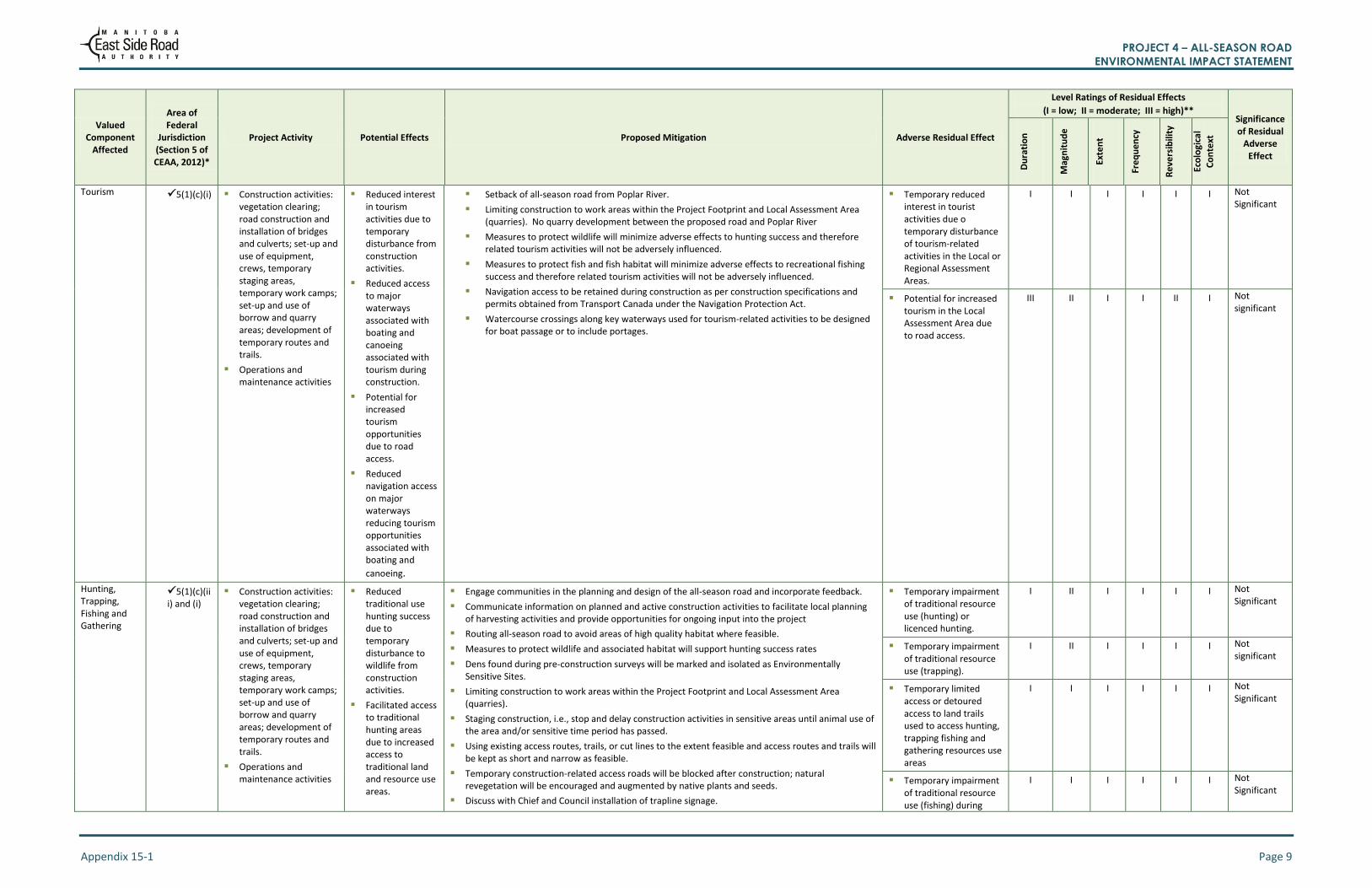
Tourism
5(1)(c)(i) Construction activities: vegetation clearing; road construction and installation of bridges and culverts; set-up and use of equipment, crews, temporary staging areas, temporary work camps; set-up and use of borrow and quarry areas; development of temporary routes and trails.
Operations and maintenance activities
Reduced interest in tourism activities due to temporary disturbance from construction activities.
Reduced access to major waterways associated with boating and canoeing associated with tourism during construction.
Potential for increased tourism opportunities due to road access.
Reduced navigation access on major waterways reducing tourism opportunities associated with boating and
canoeing.
Setback of all-season road from Poplar River.
Limiting construction to work areas within the Project Footprint and Local Assessment Area (quarries). No quarry development between the proposed road and Poplar River
Measures to protect wildlife will minimize adverse effects to hunting success and therefore related tourism activities will not be adversely influenced.
Measures to protect fish and fish habitat will minimize adverse effects to recreational fishing success and therefore related tourism activities will not be adversely influenced.
Navigation access to be retained during construction as per construction specifications and permits obtained from Transport Canada under the Navigation Protection Act.
Watercourse crossings along key waterways used for tourism-related activities to be designed for boat passage or to include portages.
Temporary reduced interest in tourist activities due o temporary disturbance of tourism-related activities in the Local or Regional Assessment Areas.
I I I I I I Not Significant
Potential for increased tourism in the Local Assessment Area due to road access.
III II I I II I Not significant
Hunting, Trapping, Fishing and Gathering
5(1)(c)(iii) and (i)
Construction activities: vegetation clearing; road construction and installation of bridges and culverts; set-up and use of equipment, crews, temporary staging areas, temporary work camps; set-up and use of borrow and quarry areas; development of temporary routes and trails.
Operations and maintenance activities
Reduced traditional use hunting success due to temporary disturbance to wildlife from construction activities.
Facilitated access to traditional hunting areas due to increased access to traditional land and resource use areas.
Engage communities in the planning and design of the all-season road and incorporate feedback.
Communicate information on planned and active construction activities to facilitate local planning of harvesting activities and provide opportunities for ongoing input into the project
Routing all-season road to avoid areas of high quality habitat where feasible.
Measures to protect wildlife and associated habitat will support hunting success rates
Dens found during pre-construction surveys will be marked and isolated as Environmentally Sensitive Sites.
Limiting construction to work areas within the Project Footprint and Local Assessment Area (quarries).
Staging construction, i.e., stop and delay construction activities in sensitive areas until animal use of the area and/or sensitive time period has passed.
Using existing access routes, trails, or cut lines to the extent feasible and access routes and trails will be kept as short and narrow as feasible.
Temporary construction-related access roads will be blocked after construction; natural revegetation will be encouraged and augmented by native plants and seeds.
Discuss with Chief and Council installation of trapline signage.
Temporary impairment of traditional resource use (hunting) or licenced hunting.
I II I I I I Not Significant
Temporary impairment of traditional resource use (trapping).
I II I I I I Not significant
Temporary limited access or detoured access to land trails used to access hunting, trapping fishing and gathering resources use areas
I I I I I I Not Significant
Temporary impairment of traditional resource use (fishing) during
I I I I I I Not Significant

PROJECT 4 – ALL-SEASON ROAD ENVIRONMENTAL IMPACT STATEMENT
Appendix 15-1 Page 10
Valued Component
Affected
Area of Federal
Jurisdiction (Section 5 of CEAA, 2012)*
Project Activity Potential Effects Proposed Mitigation Adverse Residual Effect
Level Ratings of Residual Effects
(I = low; II = moderate; III = high)** Significance of Residual
Adverse Effect
Du
rati
on
Mag
nit
ud
e
Exte
nt
Fre
qu
en
cy
Re
vers
ibili
ty
Eco
logi
cal
Co
nte
xt
Reduced licensed hunting success due to temporary disturbance to wildlife from construction activities.
Reduced commercial and traditional use trapping success due to temporary disturbance to wildlife from construction activities (aquatic and terrestrial furbearers).
Reduced land access to hunting, trapping, fishing and gathering resource use areas during construction.
Reduced access to major waterways associated with fishing activities during construction.
Loss or impairment of areas for berry picking and cultural/medicinal plant gatherings due to construction activities.
Watercourse crossings along key waterways used for tourism-related activities to be designed for boat passage or to include portages.
Protection of wildlife and habitat to protect trapping success
Grubbing to not block access to the existing trails, trap lines, portages and other travel corridors
Engage local communities in the planning and design of the Project to identify existing travel routes. and avoid important traditional use areas to the extent feasible.
Public access to construction sites will be restricted to minimize potential disturbance to traplines.
Hunting, trapping or harassment of wildlife by contractors, employees and agents will be prohibited.
Provide access ramps to key travel routes bisected by the all-season road.
Create temporary detours for snowmobiles and ATVs during construction.
Identify and sign detour routes and portages; ESRA’s special provision in construction contracts requires that access to key travel routes be maintained during construction.
Grubbing to not block access to the existing trails, trap lines, portages and other travel corridors.
Provide community updates regarding location and timing of construction activities that could result in limited access so that alternative routes can be planned.
Existing water flow patterns, levels and wetland hydrologic regimes will be maintained through road design.
Riparian vegetation clearing within the right-of-way will be limited to the removal of trees and tall shrubs (to maintain line of sight safety requirements) with no removal of low growing vegetation.
A vegetated buffer zone will be retained between the all-season road and lakes or ponds along the right-of-way, e.g., Bull Lake and Pamatakakowin Lake.
Where feasible, roads will be located a minimum of 100 m from waterbodies except when crossing a watercourse.
Navigation access to be retained during construction as per construction specifications and permits obtained from Transport Canada under the Navigation Protection Act.
Block and re-vegetate temporary access routes and other disturbed areas immediately after construction.
construction of key waterway crossings.
Minor loss / impairment of traditional use areas for gathering.
I I I I I I Not Significant
Access improvement to traditional land and resource use areas for hunting, trapping, fishing and gathering.
III II II III II I Not significant
Travel Routes
5(1)(c)(iii) and (i)
Clearing of vegetation; setup of equipment and crew staging and use areas; installation and use of cofferdams;
Reduced access to travel routes including land trails and waterway routes
Engage communities in the planning and design of the all-season road and incorporating feedback.
Design watercourse crossings at major rivers to accommodate navigability for canoes and motorboats as required.
Provide community updates regarding location and timing of construction activities that could
Temporary limited access or detoured access to travel routes including land trails and waterway routes.
I II I I I I Not Significant

PROJECT 4 – ALL-SEASON ROAD ENVIRONMENTAL IMPACT STATEMENT
Appendix 15-1 Page 11
Valued Component
Affected
Area of Federal
Jurisdiction (Section 5 of CEAA, 2012)*
Project Activity Potential Effects Proposed Mitigation Adverse Residual Effect
Level Ratings of Residual Effects
(I = low; II = moderate; III = high)** Significance of Residual
Adverse Effect
Du
rati
on
Mag
nit
ud
e
Exte
nt
Fre
qu
en
cy
Re
vers
ibili
ty
Eco
logi
cal
Co
nte
xt
bridge and other watercourse crossing installations; equipment, machinery and vehicle use; and road construction activities.
Operations and maintenance activities.
during construction and maintenance activities.
Reduced access to travel routes including land trails and waterway routes.
result in limited access so that alternative routes can be planned.
Identify and sign detour routes and portages.
Pause work for access during key times at key locations.
Create temporary detours for snowmobiles and ATVs during construction.
Provide access ramps to traditional travel routes bisected by the all-season road.
Inform the communities regarding the location and timing of maintenance activities (e.g., bridge maintenance) that may require alternative travel route planning
Limiting construction to work areas within the Project Footprint and Local Assessment Area (quarries)
Temporary reduction in access to travel routes including land trails and waterway routes during maintenance activities.
I II I I I I Not Significant
Cultural Heritage and Archaeo-logical Resources
5(1)(c)(ii), (iii) and (iv)
Clearing and construction activities.
Loss and damage of known and unknown cultural, heritage and archaeological sites and objects in the Local Assessment Area during construction.
Engage communities in the planning and design of the all-season road and incorporating feedback.
Communicate information on planned and active construction activities to facilitate traditional ceremonies in advance of construction.
HRIAs have been conducted and all known priority/significant sites have been avoided through route modifications.
Conducted traditional knowledge studies and heritage resource assessments to identify archaeological, heritage and cultural sites.
Flag construction exclusion areas around discovered/previously unknown cultural, heritage and archaeological sites when encountered during construction and operations and maintenance activities and Identify construction exclusion zones on right-of-way mapping for contract administrators.
Relocate heritage resources that would be destroyed by construction/maintenance activities only with consent from Manitoba Heritage Resources Branch and the local community.
Consult with the local community and/or the Métis on culturally appropriate measures procedures to follow if archaeological sites or objects are exposed during construction.
Provide instructions to contractors on procedures to follow if archaeological sites or objects are exposed during construction.
Block and re-vegetate temporary access routes and other disturbed areas immediately after construction.
None anticipated after implementation of mitigation measures.
N/A N/A N/A N/A N/A N/A N/A
Human Health and Safety
5(1)(c)(i) Clearing and construction activities including equipment, machinery and vehicle operation, rock blasting, etc.
Operations and maintenance activities including Road, ditch, culvert and bridge maintenance activities and snow clearing activities.
Reduced health and safety of community members and construction workers from road and bridge construction activities
Increased risk to health and safety of all-season road users and trail
Post “no entry”, warning signs/lights and barricades (e.g., gates, fences), where necessary, around active construction/maintenance sites and crossing locations.
Monitor and enforce restricted access conditions.
Provide community updates regarding location and timing of construction activities.
Workers to be educated regarding safe construction practices including use of Personal Protective Equipment.
Develop and implement Site Health and Safety Plans prior to construction.
Conduct regular construction site safety meetings.
Conduct regular safety inspections of construction sites.
Used trained and certified blasting crews.
Blasting locations and timing to be provided to communities and construction workers.
Risk to the health and safety of community members and workers during construction.
I I I III I I Not Significant
Risk to the health of community members and construction workers from changes to drinking water quality, air quality and noise exposure levels from construction activities.
I I III III I I Not Significant

PROJECT 4 – ALL-SEASON ROAD ENVIRONMENTAL IMPACT STATEMENT
Appendix 15-1 Page 12
Valued Component
Affected
Area of Federal
Jurisdiction (Section 5 of CEAA, 2012)*
Project Activity Potential Effects Proposed Mitigation Adverse Residual Effect
Level Ratings of Residual Effects
(I = low; II = moderate; III = high)** Significance of Residual
Adverse Effect
Du
rati
on
Mag
nit
ud
e
Exte
nt
Fre
qu
en
cy
Re
vers
ibili
ty
Eco
logi
cal
Co
nte
xt
users from accidents and collisions
Equip and maintain construction equipment, machinery and vehicles with appropriate safety features (e.g., back-up warning devices).
Speed limits on road to be established based on road design.
Ramps for snowmobiles/ATVs to be placed at road/trail crossing intersections.
Management of right-of-way vegetation to maintain driver sightlines and safety clearance.
Approved dust suppressants (e.g., water) to be used as necessary
Warning signs and reduced speed limits to be established at known wildlife crossing locations.
Warning signs and lights to be displayed for road maintenance equipment.
As required, flag persons will direct traffic around maintenance activities.
Community updates to be provided regarding the locations of scheduled maintenance activities.
Drinking Water Quality
Construction activities will not occur within 100 m of a watercourse with the exception of construction of watercourse crossings. Where a 100 m distance is not possible, a buffer zone between construction activities and the watercourse will be established according to the following formula: Buffer Width = 10 m + (1.5 X slope gradient) or 30 m whichever is greater.
In-stream work will be conducted during winter months or low flow conditions and in isolation of flowing water to avoid/minimize downstream sediment transfer.
Appropriate erosion and sediment control measures will be in place prior to the commencement of clearing and construction and will be regularly inspected and maintained to confirm effectiveness throughout construction.
Equipment, machinery and vehicles will be checked for cleanliness and leaks upon arrival to site and checked and maintained daily thereafter.
Areas for equipment fueling and cleaning will be a minimum of 100 m from a watercourse and will not drain to watercourses.
Construction crews will be adequately trained on the handling, storage and disposal of hazardous substances.
Spill clean-up kits will be available on site at all times.
Provide bottled water or on site secondary treatment to provide safe drinking water. Obtain appropriate provincial approvals for water treatment systems.
Safety plan to include advisory system to notify community and Manitoba Conservation and Water Stewardship in the event of a spill upstream of the drinking water supply.
See Chapter 7, Table 7.8 for additional water quality mitigation measures.
On-going maintenance and management of road surface and drainage infrastructure to minimize potential sediment releases to watercourses.
Maintenance equipment, machinery and vehicles maintained to avoid leaks of fuels and/or lubricants.
Maintenance crews will be adequately trained on the handling, storage and disposal of hazardous substances.
Air Quality
Vegetation will be retained as long as possible to minimize exposure time of disturbed/bare soils subject to potential erosion and associated dust/particulate generation.
Water and other approved suppressants will be used to control dust as required.
Idling of equipment and vehicles will be restricted to minimize emissions.
Routine maintenance of construction equipment and vehicles will be undertaken.
Work having the potential to create dust or smoke (e.g., blasting, debris burning) will not take place during high wind conditions.
Disturbed areas will be revegetated with native plant species following completion of the works.
Risk to the health of community members from changes to the availability or quality of country foods.
I I III III I I Not Significant
Risk to health and safety of road and trail users.
III I I II II I Not Significant
Risk to health of community members and road users from changes to drinking water quality, air quality and noise exposure levels.
III I III II I I Not Significant
Risk to the health of community members from changes to the availability or quality of country foods.
III I III III II I Not Significant
Improvement to the health and safety of road and trail users due to winter road decommissioning.
III I I II III I Not significant

PROJECT 4 – ALL-SEASON ROAD ENVIRONMENTAL IMPACT STATEMENT
Appendix 15-1 Page 13
Valued Component
Affected
Area of Federal
Jurisdiction (Section 5 of CEAA, 2012)*
Project Activity Potential Effects Proposed Mitigation Adverse Residual Effect
Level Ratings of Residual Effects
(I = low; II = moderate; III = high)** Significance of Residual
Adverse Effect
Du
rati
on
Mag
nit
ud
e
Exte
nt
Fre
qu
en
cy
Re
vers
ibili
ty
Eco
logi
cal
Co
nte
xt
Explosives will be detonated at sufficient setback distances to control for dust/debris expulsion.
See Chapter 7, Table 7.10 for additional air quality mitigation measures.
Water and other approved suppressants will be used to control dust as required.
Idling of maintenance equipment and vehicles will be restricted to minimize emissions.
Routine maintenance of equipment and vehicles will be undertaken.
Noise
Vehicles, machinery and equipment will be fitted with factory-installed noise-reducing components (e.g., mufflers, acoustic linings, shields), where possible and will be maintained to minimize excessive noise.
Explosives will be detonated at sufficient distances from communities (i.e., First Nation reserves) to minimize noise/vibration effects.
Industry best practices (e.g., blasting plans, blasting mats, appropriate charging procedures) will be when near sensitive receptors (e.g., powerlines, waterways, heritage resources) for blasting activities.
Where possible, undisturbed forested buffers will be retained around quarries to reduce noise from quarry operations.
See Chapter 7, Table 7.11 for additional noise mitigation measures.
Maintenance vehicles, machinery and equipment will be fitted with factory-installed noise-reducing components (e.g., mufflers, acoustic linings, shields), where possible and will be maintained to minimize excessive noise.
Where possible, undisturbed forested buffers will be retained around quarries to reduce noise from quarry operations.
Availability/Quality of Country Foods
Community input into alignment routing, component siting and road design avoid important areas of botanical and wildlife resources that serve as country foods to the extent feasible.
Use existing access routes, trails and cut lines to the extent feasible to minimize removal of vegetation and habitats.
Stage constructions as required (i.e., stop and delay construction activities in sensitive areas until animal use of the area and/or sensitive time periods have passed).
Maintain existing flow patterns, water levels and hydrologic regimes of drainage paths, wetlands and watercourses/ waterbodies.
Retain vegetated buffer zones along watercourses, lakes and ponds.
Application of ESRA GR130s, Environmental Protection Procedures and mitigation measures identified above to minimize changes to water quality, air quality and noise levels that may temporarily alter the distribution of plants and animals serving as country foods.
Reclaim and rehabilitate areas disturbed by construction to encourage natural regeneration/regrowth of vegetation and habitat restoration.
See Chapter 9, Tables 9.15, 9.21, 9.25, 9.31, 9.37, 9.41, 9.46 and 9.50 for additional mitigation measures related to the availability and quality of country foods.
Schedule road, bridge and culvert maintenance activities during fall and winter to the extent feasible to avoid sensitive lifecycle periods for animals serving as country food.
Maintain signage and speed reduction zones where necessary to minimize potential wildlife-vehicle collisions.
Optimize line of sight through vegetation management to minimize potential wildlife-vehicle collisions.
Maintain existing flow patterns, water levels and hydrologic regimes of drainage paths, wetlands and watercourses/waterbodies.

PROJECT 4 – ALL-SEASON ROAD ENVIRONMENTAL IMPACT STATEMENT
Appendix 15-1 Page 14
Valued Component
Affected
Area of Federal
Jurisdiction (Section 5 of CEAA, 2012)*
Project Activity Potential Effects Proposed Mitigation Adverse Residual Effect
Level Ratings of Residual Effects
(I = low; II = moderate; III = high)** Significance of Residual
Adverse Effect
Du
rati
on
Mag
nit
ud
e
Exte
nt
Fre
qu
en
cy
Re
vers
ibili
ty
Eco
logi
cal
Co
nte
xt
Road designed with no pull-outs or parking areas.
Note: *In accordance with CEA Agency Guidelines for this Project, a check mark () is indicated for those VCs that are considered ‘environmental effects’ as defined in the Canadian Environmental Assessment Act, 2012. For those VCs considered ‘environmental effects, reference to the relevant subsection of the Act is indicated.
** Refer to Chapter 6, Section 6.4 for definitions of impact assessment criteria. N/A = Not applicable