Round 3 - Province of Manitobacontent.gov.mb.ca/.../pdf/project_p7a/appendices/round3.pdf · 2018....
13
Round 3
Transcript of Round 3 - Province of Manitobacontent.gov.mb.ca/.../pdf/project_p7a/appendices/round3.pdf · 2018....

Round 3

Meeting 3
Little Grand Rapids First Nation

LITTLE GRAND RAPIDS FIRST NATION COMMUNITY MEETING
REVISED ALIGNMENT and CROSSINGS DISCUSSION
Date: December 3, 2013
Time: 10:30 am – 2:30 pm
Location: Little Grand Rapids First Nation Band Hall
In Attendance: ESRA Project Team
Dan Kuenstler, Leanne Shewchuk, James Fraser, Jaime Clarke,
Peter Myers, Robert Cottreau, Cindy McKay, Lawrence Isaac
(GIS Consultant)
Registered LGR FN Community Attendees:
Henry Bushie, Norman Owen, Hendrik Bushie, Kyle Morriseau
(?), Gordon Pascal, Terry Bushie, (?) Pascal, Clifford Keeper,
Lena Leveque, Elizabeth B Eaglestick, Clarence Keeper,
Clifford Keeper Sr., Sally Eishen, Rudy Keeper, Lawrence
Baptist, Colin Keeper, Alvin Bushie, Clifford Keeper Jr.,
Eugine Leveque, ? Keeper, Mildred Bushie, Richard Keeper,
Sally Leveque, Bobby Keeper, Ruby McKay
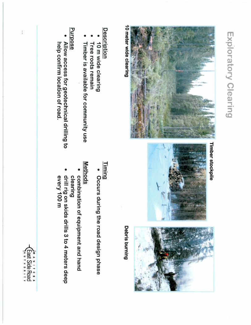
Open House
In the morning, MFESRA posted maps and drawings around the band hall for LGR community members
to view on their own. The boards posted showed the proposed alignment, along with inset photos of the
two main water crossings, Root Creek and Channel between Fishing and Family Lakes, construction and
preconstruction activities, and a flow chart showing the steps to select, design and construct an all season
road. MFESRA staff members were positioned at each board to answer questions community members
raised. Discussions around project activities occurred at each board.
ESRA Presentation
Chairs facing the back wall were set up for people to view the formal presentation. A timelapsed video of
an Acrow Panel bridge installation was shown to provide community members with an idea of what
Acrow Panel bridges look like, how they are installed and what they look like on the landscape. This is
the bridge type that is under preliminary consideration for the two main water crossings.
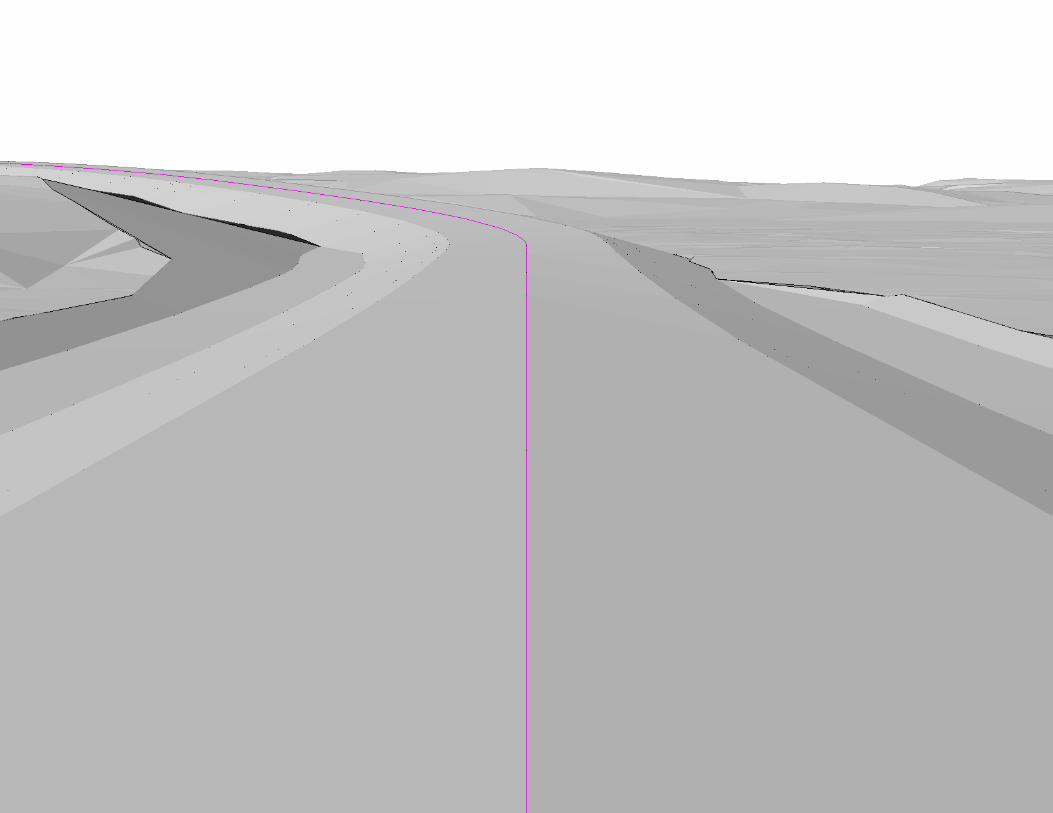
ESRA presented a projection of a run through of the current alignment using Softree software. This
allowed people to see what the road could potentially look like on the landscape. Discussions were had
regarding drainage across the landscape and MFESRA’s proposed mitigation measures to maintain
drainage (i.e. installation of equalization culverts). Examples of ancillary works performed on a typical
site were presented to familiarize community members with current construction practices.
Longer discussions were held on the two major crossings, Root Creek and the Channel between Fishing
and Family Lakes, that included MFESRA’s presentation of draft fisheries field data (North South
Consultants), discussion on community use of the land and potential mitigation measures to accommodate
continued community use during construction and operation of the all-season road. A short description of
the TK workshop conducted the day before was also provided including a review of the potential species
Room 200, 155 Carlton Street
Winnipeg, MB R3C 3H8
Phone: (204) 945-4900
Toll-Free: 1-866-356-6355 Fax: (204) 948-2462

– 2 –
at risk. An explanation of the environmental impact assessment process and opportunities for community
input was provided.
Richard Keeper
Dan, James, and Leanne spent time discussing the road and implications to a Richard Keeper, local
trapper whose trapline is crossed by the proposed alignment.

Large Area Network Study to identify
possible road corridors
Identify Possible Road Alignments
(within the corridors)
Select Final Road Alignment
Detailed Design Construction
Engineering Assessment (Broad)
· Terrain Analysis (broad scale)· Environmental considerations· Road requirements
Community Input· Community Meeting #1
(linkages and direction) · Traditional Knowledge Study
(broad scale)· Community Meeting #2 (results
of assessments & preferred corridor)
Engineering Analysis (preliminary)
· Terrain Analysis (detailed air photos, soil conditions)
· Crossing information· Community Input· Environmental Studies· Initiate Exploratory clearing
Community Input· Community Input – road
options · Traditional Knowledge Study
(detailed)
Start Environmental Assessment
Community Input· Construction details and
mitigation· Construction approach· Refine design · Timelines for proposed work
Environmental Assessment Submission
Community Input· Community Input – preferred
road options · What is important to protect
and how to protect it· Discuss sources of potential
construction materials
Discuss Environmental Assessment
Engineering Analysis (functional)
· Complete Exploratory Clearing and conduct soil drilling
· Preliminary Design of road and bridges
· Identify quarries· Environmental Assesment
Community Input
· Status Updates· Project Monitoring · Feedback on Construction and
Environmental Protection· Employment opportuntiies
Environmental Assessment Approved/Monitoring
Engineering Analysis (Final)
· Final Design of Road and Bridges
· plan temporary camps and finalize quarries and borrow
· Confirm environmental protection


ROOT CREEK CROSSING DISCUSSION
ORIGINAL SITE
PROS: Away from forebay and rapids
CONS: Longer crossing, swamp material on one side rock on the other, parallels the portage – impeding ones movement, larger
disturbance to the environment, poor terrain on north side, longer road network, further from staging areas for boat/snowmobile
access
NEW SITE
PROS: Short crossing, rock on both sides for constructability, crosses portage at 90 degrees, shorter road network, closer to
potential staging area for boat/snowmobile access, clear span
CONS: Bridge over rapids (Sasagiu Rapids Bridge picture),

Meeting 3
Pauingassi First Nation

Community Meeting in Pauingassi
Date: May 23, 2012
In Attendance: Leanne Shewchuk – MFESRA
Dennis Watson – MFESRA
Rob Cottreau – MFESRA
James Fraser – MFESRA
Doug Peterson – MFESRA
Karl Zadnik – MFESRA
Norma Spence – MFESRA
Harold Crow – Chief
Michael Crow – Councillor
James Crow – Councillor
Location: Pauingassi Band Office
Comments in advance of meeting:
Identification of moose hunting areas
Identification of crossing concerns near airport
Identification of boat access – 14’-18’ with 25 to 50 horse power engines (Allen Owen)
Community Meeting:
MFESRA posted maps and drawings around the Band Hall for Pauingass community
members to view. These materials presented the proposed alignment, construction and
preconstruction activities, and flow charts describing the process for route selection,
design, and construction of an all-season road. Information regarding training and
employment for construction-related activities was also provided. MFESRA
representatives answered community members’ questions regarding these materials. Approximately 40 community participants were in attendance. Presentation by MFESRA on history of the project and overview of MFESRA with
translation by Hubert Crow. MFESRA projected live GIS working maps of the all-season road on the wall of the Band
Hall, allowing community members to make suggested alterations to the road alignment.
Changes were incorporated in live time.
Comments:
James Fraser discussed map and review by Little Grand Rapids
Room 200, 155 Carlton Street
Winnipeg, MB R3C 3H8
Phone: (204) 945-4900
Toll-Free: 1-866-356-6355 Fax: (204) 948-2462

– 2 –
Main objective is to link both LGR and Pauingassi to airport. Later the connection to the
ASR currently under construction from PR304 to Berens will be developed. Road stops at reserve boundary – on reserve road to dump Looking for input from you on the route – are there sensitive areas to be avoided, are
there preferences for location Hunting areas near small lakes to the east of Fishing Lake. Shores and high rock are used
for hunting. Want road further from these lakes (100m is too close) For the first 3 km out of the community of Pauingassi, the preference was to follow the
hydro line. Do they access LP011 10 and LP010 9 crossing – no paddle craft use. At LP010 9 there
is a Portage Trail to Lake Crossings at LP022 8 and LP021 7 – no paddle craft use – beaver dams Rocks not too high in this area Crossing LP020 6 – paddle craft use Crossings LP019 5 and LP018 4, LP017 3 – paddle craft use Crossing LP017 3 and LP016 2 – hunting area – should this move to power line Pauingassi community members in attendance preferred the new alignment suggested
during the meeting. Nothing identified that would be a problem for this new revised portion of the alignment.
No cabins, important trapping areas identified Crossing LP005 0 over river north of airport good as long as it accommodates 14-18’
motor boats. – Community confirmed. Looked crossing LP005 0 crossing – deep water and 180m long – rejected.
MFESRA raised the issue of the two communities working together and cooperating on location
or alignment and construction work.