Layout and design by Arnold Navneet Lal Issue 1- 2018 ...
13
Layout and design by Arnold Navneet Lal Graphics Arst SPC SOPAC IN THIS ISSUE Initiated in 1993, the Pacific GIS&RS Newsletter, which is now facilitated through the PGRSC Council, has since been an information and knowledge tool for the Pacific region. 1 PACIFIC ISLANDS GIS&RS NEWSLETTER Issue 1- 2018 ISSN: 562-4250 The Newsletter is Back on Track Finally we have the Pacific Islands GIS&RS Newsletter out again. This newsletter is now published by the Pacific GIS and Remote Sensing Council. The Newsletter has a long history: The first GIS and RS Newsletter was published in 1993 and distributed in Fiji. There was a need for a regular information platform as there was no Fiji medium (i) to report and document the monthly GIS&RS User Meeting, (ii) to distribute new developments in the areas GIS, RS and upcoming GPS applications, (iii) to report about data available in Fiji. The Newsletter started as a simple print out of a WordPerfect written A4 document edited by Wolf Forstreuter and Les Allinson. In 1994 SOPAC’s Director supported the Newsletter with professional staff and Lala Bukarau joining the team. James Britton (USP) joined the newsletters working group in 1998. During the time users of other Pacific states were interested in the newsletter where SOPAC printed and posted to Pacific island countries. Shortly afterwards, a network was established of national focal points, which than produced bigger quantities and which was distributed to subscribers in country. By the end of the nineties the Newsletter was able to be downloaded from the SOPAC website, however, the postage of newsletters continued as the countries e-mail access was very limited. The newsletter can still be printed if there is a need, however, this is an exception. The last issue was published two years ago as there was no time which could be allocated to this publication. The PGRSC took ownership and the newsletter will be published again in regular intervals. The importance is that the newsletter is the only publication, which focuses on spatial data application in Pacific Island Countries. We have a very small editorial team: Navneet Lal does the graphical outfit, Sereima Kalouniviti performs the editing of the articles if necessary and Wolf Forstreuter keeps the communication to get articles in. PACIFIC GIS AND REMOTE SENSING COUNCIL Newsletter Editorial Team WOLF Forstreuter SEREIMA Kalouniviti NAVNEET Lal The Newsletter is Back on Track Launching of the Pacific GIS and Remote Sensing Council The Pacific Islands GIS and RS User Conference 2017 TIMMS: Making the impossible attainable Moving to the Cloud The Pacific and the Opportunity for Geospatial Big Data HIGH PRECISION COASTLINES AT GLOBAL SCALE or how to exploit terabytes of very high resolution satellite imagery in the cloud to analyse coastlines at a country scale 2017 Pacific GIS & RS Annual User Conference – Opening Speech by the Hon. Minister for Industry, Trade, Tourism, Land and Mineral Resources, Mr. Faiyaz Siddiq Koya. Philipp Müller Memorial Address Closing Address by Dr Russell Howorth Previous GIS&RS Newsletters
Transcript of Layout and design by Arnold Navneet Lal Issue 1- 2018 ...

Layout and design by Arnold Navneet Lal
Graphics Arti st SPC SOPAC
IN THIS ISSUE
Initiated in 1993, the Pacifi c GIS&RS Newsletter, which is now facilitated through the PGRSC Council, has since been an information and knowledge tool for the Pacifi c region.
1
P A C I F I C I S L A N D S G I S & R S N E W S L E T T E R
Issue 1- 2018ISSN: 562-4250
The Newsletter is Back on TrackFinally we have the Pacifi c Islands GIS&RS Newsletter out again. This newsletter is now published by the Pacifi c GIS and Remote Sensing Council. The Newsletter has a long history:
The fi rst GIS and RS Newsletter was published in 1993 and distributed in Fiji. There was a need for a regular information platform as there was no Fiji medium (i) to report and document the monthly GIS&RS User Meeting, (ii) to distribute new developments in the areas GIS, RS and upcoming GPS applications, (iii) to report about data available in Fiji.
The Newsletter started as a simple print out of a WordPerfect written A4 document edited by Wolf Forstreuter and Les Allinson. In 1994 SOPAC’s Director supported the Newsletter with professional staff and Lala Bukarau joining the team. James Britton (USP) joined the newsletters working group in 1998. During the time users of other Pacifi c states were interested in the newsletter where SOPAC printed and posted to Pacifi c island countries.
Shortly afterwards, a network was established of national focal points, which than produced bigger quantities and which was distributed to subscribers in country. By the end of the nineties the Newsletter was able to be downloaded from the SOPAC website, however, the postage of newsletters continued as the countries e-mail access was very limited.
The newsletter can still be printed if there is a need, however, this is an exception. The last issue was published two years ago as there was no time which could be allocated to this publication. The PGRSC took ownership and the newsletter will be published again in regular intervals.
The importance is that the newsletter is the only publication, which focuses on spatial data application in Pacifi c Island Countries. We have a very small editorial team: Navneet Lal does the graphical outfi t, Sereima Kalouniviti performs the editing of the articles if necessary and Wolf Forstreuter keeps the communication to get articles in.
PACIFIC GIS ANDREMOTE SENSING COUNCIL
which than produced bigger quantities and which was distributed to which than produced bigger quantities and which was distributed to which than produced bigger quantities and which was distributed to which than produced bigger quantities and which was distributed to subscribers in country. By the end of the nineties the Newsletter which than produced bigger quantities and which was distributed to which than produced bigger quantities and which was distributed to subscribers in country. By the end of the nineties the Newsletter was able to be downloaded from the SOPAC website, however, subscribers in country. By the end of the nineties the Newsletter was able to be downloaded from the SOPAC website, however, was able to be downloaded from the SOPAC website, however, the postage of newsletters continued as the countries e-mail
The newsletter can still be printed if there is a need, however, this is an exception. The last issue was published two years
The importance is that the newsletter is the only publication, which focuses on spatial data application in Pacifi c Island Countries. We have a very small editorial team: Navneet Lal does the graphical outfi t, Sereima Kalouniviti performs the editing of the articles if necessary and Wolf Forstreuter keeps the communication
was able to be downloaded from the SOPAC website, however, the postage of newsletters continued as the countries e-mail was able to be downloaded from the SOPAC website, however,
The importance is that the newsletter is the only publication, which focuses on spatial data application in Pacifi c Island Countries. We have a very small editorial team: Navneet Lal does the graphical outfi t, Sereima Kalouniviti performs the editing of the articles if necessary and Wolf Forstreuter keeps the communication
Countries. We have a very small editorial team: Navneet Lal does the graphical outfi t, Sereima Kalouniviti performs the editing of the articles if necessary and Wolf Forstreuter keeps the communication
Newsletter Editorial Team
WOLF
Forstreuter
SEREIMA
Kalouniviti
NAVNEET
Lal
The Newsletter is Back on Track
Launching of the Pacific GIS and Remote Sensing Council
The Pacific Islands GIS and RS User Conference 2017
TIMMS: Making the impossible attainable
Moving to the Cloud
The Pacific and the Opportunity for Geospatial Big Data
HIGH PRECISION COASTLINES AT GLOBAL SCALE or how to exploit terabytes of very high resolution satellite imagery in the cloud to analyse coastlines at a country scale
2017 Pacific GIS & RS Annual User Conference – Opening Speech by the Hon. Minister for Industry, Trade, Tourism, Land and Mineral Resources, Mr. Faiyaz Siddiq Koya.
Philipp Müller Memorial Address
Closing Address by Dr Russell Howorth
Previous GIS&RS
Newsletters

2 3
P A C I F I C I S L A N D S G I S & R S N E W S L E T T E R
Launching of the Pacific GIS and Remote Sensing CouncilThe Pacific GIS and Remote Sensing Council (PGRSC) was launched on the 2nd of March 2018 at the Royal Suva Yacht Club by Hon. Minister for Industry, Trade, Tourism, Lands & Mineral Resources in Fiji, Mr. Faiyaz Koya.
The PGRSC was registered before the 2017 Pacific Islands GIS&RS User Conference and therefore needed to be launched in order to formalise it’s function and activities relating to the annual conference. The conference committee needed to outsource its own administration and funding pool as it is now an independent body outside SPC, thus the need to formalise a Council in order to acquire a separate bank account.
Minister Hon. Faiyaz Koya launching PGRSC
Group photo during the launch from left to right: Rajendra Singh (Trustee) Dr. Wolf Forstreuter (Chair), Minister Hon. Faiyaz Koya, PS Malakai Finau (Trustee) Dr. Russell Howorth (Trustee).
The Council has a postbox, a letter head, a rubber stamp and a structure of (i) three Trustees, (ii) a Board of a minimum of five members and (iii) a Conference Committee.
The Trustees are the guardians of the Council and are accountable for the organisation. These are persons who are familiar with the objectives of the Council. The three Trustees are: Permanent Secretary Lands and Mineral Resources Malakai Finau. Malakai Finau who is also Chair of the STAR[1] conference and Chair of the Fiji Geospatial Information Management Council. Mr. Finau serves as a link to both Pacific decision making bodies. Malakai Finau was also the former Director of the Fiji Mineral Resources Department, an organisation that has over the years, worked closely with the GIS and RS conference and community. Dr. Russell Howorth worked for many years at SOPAC (now the Geoscience, Energy, and Maritime Division of SPC) and at the end of his term served as the Director. SOPAC was the leading Pacific organisation in GIS and RS. Dr. Howorth is currently the Director of the Circum-Pacific Council and is also a trustee of the STAR. Rajendra Singh is known for his outstanding contribution towards education in Fiji in which he received an award by the Fiji Government.
The PGRSC Board is a requirement for the Council. The board makes far-reaching and all financial decisions. The current board members are: (i) SPC: Wolf Forstreuter, Sachindra Singh, Keleni Raqisia, Litia Gaunavou, (ii) Lands Department Fiji: Leba Gaunavinaka and Salote Viti, (iii) Forestry Department: Akosita Lewai, (iv) USP: Nick Rollings.
The PGRSC Committee is the most active arm of the Council and meet every two weeks. Most decisions and activities are made and carried out within and by the Committee members.
The Council is currently made up of mostly Fiji based representatives. Country Focal Points have been selected from most Pacific Island Countries who will be consulted with to provide inputs on country specific topics if or when the need arises.
The Constitution states five objectives of the Council:1. To promote the development of GIS and Remote
Sensing (RS) data, technologies, methods and services for the pacific region;
2. To enable collaboration and share lessons learnt across regional agencies and commercial parties;
3. To discuss and establish methods in building adaptation for the Pacific environment for solutions working already well outside the region;
4. To manage the distribution, publication and awareness of conference outcomes;
5. To establish robust links with other GIS, RS and scientific bodies regionally and globally.
These objectives overlaps with other Councils established in the Pacific and it is therefore essential for the PGRSC to establish good cooperation.
The Council distributes information through: (i) the Pacific Islands GIS&RS User Conference; (ii) Pacific Islands GIS&RS Newsletter (you are reading) which was published first in 1993; (iii) the GIS-PacNet mailing list which was established in 1996; (iv) the PGRSC website www.picgisrs.org and the facebook page https://www.facebook.com/PacGISConf/.

2 3
PACIFIC GIS ANDREMOTE SENSING COUNCIL
The Pacific Islands GIS and RS User Conference 2017The Pacific Islands GIS and RS User Conference 2017 was a success in terms of the standard and number of presentations, the networking opportunities, the discussion of GIS and RS developments and including other aspects of the event. It is with great pleasure to acknowledge here the generous and continuous support of the Donors, who have in a great way contributed to the success of the Conference and without whom the logistics and planning of the event would not have been possible. These organisations or programmes are: Fiji Lands Department; Climate and Oceans Support Program in the Pacific (COSPPac), BOM through SPC; DigitalGlobe, United States; Hexagon Safety & Infrastructure, New Zealand; Telecom Fiji Limited; University of the South Pacific (USP); Vodafone Fiji
The Conference was opened by the Minister for Industry, Trade, Tourism, Lands & Mineral Resources, Hon. Faiyaz Koya
The Conference was privileged to be opened by the Fiji Minister for Industry, Trade, Tourism, Lands & Mineral Resources Hon. Faiyaz Koya who was also present at the conference networking and social events. The opening and closing remarks were presented by the SPC-GEM Director, Mr. Andrew Jones and the former SOPAC Director, Dr Russell Howorth (the opening and closing speeches is available in the newsletter).
source software development. These discussions will be reflected in the GIS&RS newsletter and the presentations can be downloaded as PPT formats from the conference website http://www.picgisrs.org/. The conference provided an opportunity for Pacific Island Countries GIS & RS users to contribute at a regional level, which makes it different from other GIS&RS conferences in Australia, New Zealand and Hawaii. These presentations and the interactions with Pacific users makes the Conference interesting for software and hardware developments as well as consulting and data companies given that it is the only platform focused on Pacific GIS & RS users. A discussion session was also conducted and which allowed donors and companies to participate and interact with scientists and users.
Entertainment was organised every evening to allow networking, here participants during the opening cocktail.
The Discussion Session is an important part of the Conference users talk to hardware, software and data companies and to scientists to adapt
methods of GIS&RS application to Pacific environment.
Over the four day conference, donors, companies, scientists and GIS&RS users met and held separate discussions and information exchange. Discussions revolved around technical innovations such as the move to cloud computing, new drone types, the latest news of Earth observation satellite development plus new types of data and open
The 2017 Conference was organised by the Pacific GIS and Remote Sensing Council (PGRSC) of which the Conference Committee is a part of. This step was necessary as SPC had new regulations, which made it difficult for the Council to have a Conference account within the regional organisation. The transition from SPC and the opening of a separate Conference account, was carried out before the 2017 conference. A joint presentation explaining the difference between the PGRSC and the Pacific Geospatial and Surveyors Council (PGSC), will be made available soon. There are other existing regional initiatives and platforms that distribute information in the region i.e. the Science, Technology and Resource Network (STAR), the International Society for Photogrammetry and Remote Sensing (ISPRS) and the Spatial Industries Business Association (SIBA) which is linked to the PGRSC.
A social event was organised at the end of each day to prompt networking and the sharing of knowledge amongst participants, and this was a success. The opening cocktail

4 5
P A C I F I C I S L A N D S G I S & R S N E W S L E T T E R
GIS/RS Articles“Welcome to the fi rst in a series of articles that will challenge the current understanding
of what the geospatial industry includes. While the PI countries focus on GIS and remote sensing for good reason, the rest of the would now includes industries such as architects, plumbers, metal workers, electricians, consultants and engineers. More and
more people understand their roles and activities happen in a spatial environment.”
Warren Eade, AllTerra PI Sales Manager
TIMMS: Making the impossible attainableTo say the TIMMS makes the impossible possible may be an overstatement. But to say it makes it more achievable rings true.
TIMMS – the Trimble Indoor Mobile Mapping Solution – has truly changed the face of how interior spaces are scanned in 3D, allowing laser scan surveys not only in situations that would have been diffi cult, to say the least, but also in an incredibly time-effi cient manner.
For Victorian-based Taylors, the fi rst fi rm in Australia to acquire TIMMS, its adoption has amply demonstrated those qualities – and more.
Taylors, with offi ces in Melbourne, Brisbane, Christchurch and Jakarta, prides itself on being a company on the leading edge of new technology. As Taylors’ Manager – 3D Modelling and BIM, Alastair MacColl explained, indoor laser scanning had been identifi ed as an area of advancement it was particularly keen to explore.
was hosted by DigitalGlobe while the Yaqona night welcomed participants from other countries in the Fijian way of socialising and kava drinking. On Wednesday a guided tour through Suva’s night life was organised, where typical Fijian hotspots were selected. The closing cocktail took place on Thursday in which awards were handed out by SIBA for innovation in the geospatial sector. The Council provided prizes for projects of students and professionals. Friday was reserved for workshops, however, at the end of the day, the GEM Talanoa (Fijian word for chatter) Club was open to participants. On Saturday a BBQ was organised at the sandbank out in the Suva reef.
There were several workshops conducted on Friday after the Conference. Hirdeshni Gautam provided an information session on radar data enhancement and processing, which is a new area in the Pacifi c. Martin Isenburg introduced LiDAR processing and cloud point analysis. Olivier Dalang and Jonah Sullivan conducted a workshop on QGIS customisation and Richard Russell held a workshop on drone fl ying.
The 2017 Conference attendance was one third less compared to the 2016 and 2015 conference. This was due to several platforms which was also taking place at the same time i.e the (i) Heads of Fisheries meeting (FFA) in Noumea, (ii) Heads of Statistics meeting in Nadi and (iii) Surveyors were involved in large scale survey projects in Tonga and Tuvalu, which prevented surveyors from attending the conference. 335 people registered online for the conference of which 125 was not able to attend. At the fi nal discussion session participants suggested that the 2018 conference apply a minimum charge of FJD 10 to 20 for the registration process to avoid this in future.
It also was suggested that the Conference will be more regionalised and was agreed that in 2020 Vanuatu will host the Conference. The Council will establish country focal points to have more country inputs to the way the Conference will be conducted.
This year the poster competition was divided in a student and in a profession-al one. It was besides presentations another avenue to showcase projects.
SIBA Spatial Excellence Award was handed out during the closing cocktail

4 5
PACIFIC GIS ANDREMOTE SENSING COUNCIL
Alastair said the fi rm acquired its TIMMS in January, 2017 and that it had not only demonstrated Taylors commitment to early adoption and investment in new technology, but also allowed it to tender for large, complex projects that may very well have been outside its scope without TIMMS.
A prime example of this was a project in the heart of Melbourne’s CBD where detailed interior scans of an entire 30-storey tower were needed for a planned refurbishment.
“The building is a mix of hotel rooms and serviced apartments,” Alastair said.
“As you can imagine, not only did this involve many, many rooms but also could not be carried out within standard timings.
“The client had specifi c times we could access the various fl oors and rooms which would have been incredibly complex using traditional laser scanning technology.”
But with the TIMMS, the Taylors team was able to quickly and effi ciently scan each room and fl oor within the specifi c timings. A job that surely would have taken weeks and weeks using traditional technology was achieved in days.
“We were literally in and out of rooms in minutes and with the highly detailed and complex information we needed to create the 3D modelling of course,” Alastair said.
“With a tripod-based scanner I would imagine that each room would have taken more than half-an-hour.
“Another big advantage the TIMMS had on this job was that we could link each fl oor in the modelling simply by rolling the
TIMMS into the lift after we’d completed a fl oor and go up or down to the next level.
“As we were scanning continuously, this use of the lift created that link on the plans and its elevation.
“Traditional, tripod-based laser scanners cannot be moved during scans. TIMMS works when you are moving. It is a huge difference and makes this technology unique.”
Alastair reports the client was more than happy with the team meeting the access requirements as well as the end result – second-to-none 3D modelling delivered to the project architects in a timely manner.
“For Taylors, TIMMS has taken our work and the kind of projects we can complete to a new level,” Alastair said.
The TIMMS system is available in Australia through Trimble’s authorised dealer, UPG, and in New Zealand from AllTerra.
UPG’s Martin English said Taylor’s adoption of the TIMMS system had been an Australian fi rst and a massive step forward for this industry in our country.
“Taylors is demonstrating that the adoption of this technology means big things for a business,” he said.
“It truly is a step into the future and is ensuring Taylor not only remains a competitive operation but is on the leading edge.
“The work Taylors is doing with its TIMMS is ground-breaking and we’re proud to be a part of this next, exciting chapter in 3D modelling and BIM.”
To take your business to a whole new level too, talk to your AllTerra rep about how TIMMS can revolutionise how you work.

6 7
P A C I F I C I S L A N D S G I S & R S N E W S L E T T E R
Moving to the Cloud - By Ken Mathers
There is no doubt that cloud-based solutions are increasing in demand across government, private industry, and the consumer IT markets. Many organizations currently face challenges associated with deployment of individually-installed desktop-based software across an enterprise. These issues can include complexity in managing and monitoring desktop software usage, slow upgrade cycles, lack of fl exibility in meeting increased demand or supporting mobile users, and high maintenance and support costs. Many of these organizations know cloud-based solutions provide benefi ts such as streamlined and reliable software management processes, more frequent technology update cycles, robust support for remote and mobile users, and reduced maintenance and support costs.
From a government organizational standpoint of providing uninterrupted services to internal users, mission partners, or the general public, additional benefi ts to cloud-based services include failover, redundancy, and load balancing for changing demand cycles. From an end user’s standpoint, the advantages are ubiquitous access from virtually any location and any device (for example, desktop, laptop, tablet), less disruption due to upgrades of software, and secure backup copies of important data and documents.
Software Delivery Models Move to the CloudsThe growing popularity of cloud offerings of mainstream products is indicative of an irreversible trend. Cloud-based solutions such as Offi ce 365, Google Apps, Adobe Creative Cloud, and Salesforce.com are evidence of this. A few of these examples such as Google Apps and Salesforce.com, represent solutions fi rst born in the cloud (being completely web-based from their inception), while others, such as Offi ce 365 and the Adobe solutions represent a business and technology shift away from physical machine-based perpetual licensed software to a user-based subscription licensing model also called Software as a Service (SaaS). In Microsoft’s example, users or organizations would previously purchase discs with Microsoft Offi ce (Word, Excel, PowerPoint, etc.) and install these versions on a laptop or desktop computer. With the cloud-based model, users now pay online for a subscription to the Microsoft 365 service and they then download the selected modules to their computing devices. Additionally, as is the trend with music and movies, physical digital media is no longer in high demand. Walking into a brick and mortar store to purchase a software application that you can call your own is declining. The storage and management on a remote server of user data itself is an integral part of these cloud-based subscriptions.
Geospatial Industry TrendsCloud-based solutions are also becoming adopted throughout the geospatial industry. Client-server and web-based access to mapping and navigation applications has been a mainstay for well over a decade and have in part represented a partial move away from desktop software. Many government agencies provide outward-facing web services to mission partners or the general public for downloading maps and imagery. In some cases, basic analysis and processing capabilities are available. However, many client-
server solutions such as Google Earth that provide simple viewing and analysis are limited in their applicability to support the wide range of geospatial requirements that many organizations face. Furthermore, they often do not provide the level of accuracy required. The move to the cloud takes web-based access further by providing substantial improvements in performance, accessibility, accuracy, and reliability not only to those outward-facing services, but also to the wide range of internal geospatial applications and processes.
Challenges of Big DataA key challenge facing the geospatial community in particular has always been dealing with the large amounts of geospatial data being managed and accessed, especially remote sensing data types such as satellite imagery, aerial photography, LiDAR, and radar. As more ground-based, airborne, and orbital sensors are deployed at an astounding rate and the resolutions of datasets also grow, the industry must address data security, discovery, access, and performance as an integral part of any cloud-based geospatial solution.
Challenges of Complex ApplicationsGeospatial applications have typically held the stigma of being very costly, isolated, or “stovepiped”, and complex, often requiring specialized training for users to become profi cient. With the growing amount of geospatial data driving new and exciting applications of the technology, improved battery life and computing power on mobile devices, and continually improving network availability and bandwidth, the possibilities for the geospatial community to harness the power of the cloud to make monumental contributions in new areas is very real and exciting. In order for this to truly take fl ight, the industry cannot move forward relying on deploying the same complex geospatial applications from a cloud server in a SaaS manner.

6 7
PACIFIC GIS ANDREMOTE SENSING COUNCIL
Virtualisation is Not the AnswerVirtualization is essentially a mechanism of providing users access to a software application on a remote server. Processing and access to data essentially happen on this remote server, and the display, mouse, and keyboard interaction occurs on a traditional computer. In many cases the application is the same one that a user may have previously been using on a local machine. Granted, the pure SaaS model does provide some advantages from a lower cost IT maintenance and management perspective, but it can create substantial additional drain on network resources and does not function in disconnected user environments. Additionally, sometimes no savings are realized in training or even software licensing costs. Furthermore, virtualization perpetuates another problem - if the application was difficult to use previously, it is still difficult to use. The solution to further improve SaaS in a cloud deployment can be realized by building more lightweight, intuitive, mission-specific applications. This can be accomplished by decomposing heavyweight geospatial software into useful stand-alone functional elements that can be reassembled into more streamlined applications. User experience is improved, training costs are reduced, and less computing resources and network bandwidth are used.
Open Standards Based SolutionsOpen standards are critical for improved geospatial collaboration within and across organizations today because open standards offer vendor-neutral methods to share data between diverse systems and applications. System architectures that are based on open standards support a model where technology refreshes happen frequently and reliably, essentially enabling an organization to innovate and evolve at a rapid pace. Hexagon is a founding member of the Open Geospatial Consortium (OGC) and produces the largest collection of open standards-based geospatial products of any company in the world. Hexagon Geospatial product lines undergo development with open standards-based sharing as a key focus, so open standards support is essentially embedded within the product’s DNA rather than included as an afterthought.
Open data sharing has always been a key aspect of open standards-based geospatial solutions. The initial focus on OGC standards was on open geospatial data formats such as Web Mapping Service (WMS) and Web Feature Service (WFS) that allow for vendor-neutral serving and sharing of data. These standards have evolved to include server-based execution of geospatial processes via OGC Web Processing Services (WPS) and the more modern, versatile protocol Representational State Transfer (REST), or RESTful, services. These web services allow a remote user to discover remote geospatial processes, link them to data sources, execute the remote process, and then exploit the results. A core feature of the cloud-based solution is that users can also create these geospatial services directly from a cloud-based authoring tool and publish them to be available as RESTful services.
Geospatial as an InfrastructureGeospatial solutions have evolved over the past few decades from a science to an industrial technology and now to the point of being considered integral to the IT infrastructure for many enterprises. Instead of a specialty application that requires high-end computing devices, advanced technical knowledge, and large amounts of training, geospatial solutions now seamlessly integrate into our daily professional and personal experiences in many beneficial ways.
Geospatial processing is widely accessible to the broad population via a plethora of devices and methods. This is evidenced by the fact that geospatial technologies are such an innate and essential part of our modern lives, like running water or the Internet, that these services are becoming more reliable and ever-present. The GPS technology that is in our cars, on our smart phones, and embedded in our watches represents this state. Geospatial integration with social media is also a key example of how ingrained geospatial data is in our everyday lives. For example, Foursquare, a location-based service, lets people leave ‘tips’ (or notes) at participating locations for their friends or for other people that may show up later. If you visit a restaurant, you can leave a specific tip using Foursquare such as what you thought about a specific entrée, “in the cloud.” Then, when other subscribers show up and check in, their Foursquare-enabled smartphones pull those tips out of the cloud for viewing. This occurs effortlessly and elegantly, with no thought at all by the user given to any geospatial aspect.
Within a large organization’s IT enterprise, the cloud-based exploitation solution moves high-end geospatial processing and analysis from a desktop-constrained technology to an infrastructure. This enhances daily operations and improves mission effectiveness by making the geospatial processes more readily accessible and intuitive to operate in a manner that seamlessly integrates these geospatial processes into the fabric of the organization.
Providing accurate information on the shoreline and variations of water level in intertidal zones at large scale and economically profitable is beneficial for the environment, the populations and for the economic development. In the context of climate change, the interface between the lands and the sea is at the forefront for the protection of people and the economic and social sustainability of the coasts. The easy and shared access to these information by the different communities (experts, scientists, managers, decision-makers, engineering consultancies) ensures that the information is appropriated for the benefit of sustainable development. And especially in the Pacific region, the regular and accurate updating of these descriptors is a growing need of all the communities (populations, decision-makers, planners and scientists).
High Precision Coastlines at Global Scale received the Award for Innovation and Commercialisation for the Pacific Islands from SIBA in November 2017 (Suva, Fiji) - Nominee: BLUECHAM SAS and Contributors: BLUECHAM SAS and DigitalGlobe.

8 9
P A C I F I C I S L A N D S G I S & R S N E W S L E T T E R
The Pacific and the Opportunity for Geospatial Big Data- By Peter Kinne, Regional Director DigitalGlobe
Prior to 1956, computing options were limited to adding machines and punch card computers. Although a revolution in its own right, this format was not able to keep up with the growing complexity and increasing data needed for business and scientifi c analysis. In 1956, the fi rst RAM disk became available and allowed the move from punch cards to the brand new 5MB Hard disk pictured in Figure 1.
Now realise how far we have come from hard disks to RAM drives to cloud computing. Most people do not even think about it but almost all of us have cloud based social media accounts, photo libraries, or even storage options for offi ce applications. We already use cloud computing every day.
Figure 1 – First hard drive by IBM with a capacity of 5MB
Figure 2 – Amazon Web Services’ Snow Mobile at DigitalGlobe
Figure 3 - Streamlined workflows to constantly improve analytics.
So why is spatial data taking longer to shift to the cloud? The diffi culty is that geospatial and more specifi c remote sensing has the biggest of the big data industry. DigitalGlobe confronted this in 2017 when, after years of planning, it proceeded to move its entire 100PB archive into the cloud. In 1956 this would have taken up 21,475,836,480 IBM 5MB hard drives. Even today it would still take around 300 years to download over the typical home broadband plan. Clearly, we needed something new and innovative and that’s exactly what happened. Amazon Web Services invented the fi rst of its kind data delivery service just for DigitalGlobe. Called Snow Mobile, it holds 100PB of data and can transport it to data centres for storage. This could be the world’s largest USB
stick and Figure 2 shows it plugged into the DigitalGlobe head offi ce to download the archive.
Cloud-based computing platforms can provide real business benefi ts for the Pacifi c region (refer to Figure 3):
Reducing the access cost of imagery – Cloud platforms allow a reduced investment pathway for the use of imagery without the need to purchase. This means greater access for the same budget.
Continuous Improvement and Repeatability - Once you develop algorithms in the cloud others can use them for their countries. Figure 3 illustrates how collaboration and continuous improvements are more easily achieved in Cloud infrastructure.
Reduced Analytic Cost – There is always a cost in setting up and maintaining the latest computer and software systems and they are not easily maintained in humid climates. If the data is stored in the cloud, then leaving it there and retrieving only the answers to your analytics means there is a more stable and secure environment for your archives.
Skills – Cloud analytics is a fast-growing part of industry and it will continue to grow. You should get involved. Your skills will be more highly sort after through time giving you greater employment opportunities.
What Cloud means is that there are new options available to: streamline workfl ows, enable constant improvement, scale across island nations, and encourage capacity and capability in the Pacifi c.

8 9
PACIFIC GIS ANDREMOTE SENSING COUNCIL
GBDx Plateform Architecture
HIGH PRECISION COASTLINES AT GLOBAL SCALE or how to exploit terabytes of very high resolution satellite imagery in the cloud to analyse coastlines at a country scale - By Rémi Andreolin
GBDx Plateform Architecture
Littoral is not a well-known zone. However, 66% of the world population resides less than 100km from coastlines and 7 of the world’s 10 largest agglomerations are on the coast ; the coast is an interface between the Ocean and the Earth; It is a place of exchange and economic development. In the context of climate change, coastal management is a global issue. The existing data doesn’t actually allow to respond to present needs: information is either accurate but sparse, or dense and mostly inaccurate.
BLUECHAM has thus developed a scientifi cally-controlled algorithm to analyse very high resolution data of the DigitalGlobe’s GBDx Platform to assess the low, high and intermediate water marks and the variations of the sea level within the intertidal zone.
The solution is based on the integration of three main components allowing users to directly access the results of their questioning:
• the Qëhnelö™ technology, that makes the connection between users and process algorithms and satellite databases online;
• the “GeoSpatial Cloud Computing”, which process interoperable data in the cloud;
• the DigitalGlobe’s GBDx Platform, which provides the very high resolution database needed to achieve the required accuracy.
The method relies on the analysis in the cloud of a time series of superspectral very high resolution images. And the results are delivered to the end-user through dedicated interfaces to which the algorithm is connected. Thus, the end-user only retrieves the requested information; the processing time is optimised; the product costs are accessible.
To ensure the effectiveness of the solution, two emerging technologies are synergistically exploited: the Qëhnelö™ technology and the GBDx platform. The implementation of these two technologies is made possible thanks to the recent innovations in GeoSpatial Cloud Computing related to the interoperability of software resources and databases.
This ensure the commercial viability of the product due to the optimization of the scale and the reduction of the following costs of production of the source data:
• the cost of the source data, as one buys an access to the data and not the data itself; - the cost of the processing infrastructure since the treatments are compiled in the cloud;
• the automation of the extraction of relevant information.
At a country-scale, obtaining information becomes therefore affordable with the same consistency and accuracy.
The Qëhnelö™ technology provides simple and effective means to access these resources to a larger number of users. The information produced are generalist and can fi nd multiple applications:
• the sensitivity of the coastline to erosion;
• the coastal risks faced by populations to guarantee and ensure the protection of property and people;
• the monitoring of coastal dynamics to assist the development, the valorisation and economy of coastlines;
• the accurate defi nition of the coastline to support local, national and international regulations;
• a measurable, sensitive and reliable indicator of global warming.
GBDx Plateform Architecture

10 11
P A C I F I C I S L A N D S G I S & R S N E W S L E T T E R
Providing accurate information on the shoreline and variations of water level in intertidal zones at large scale and economically profi table is benefi cial for the environment, the populations and for the economic development. In the context of climate change, the interface between the lands and the sea is at the forefront for the protection of people and the economic and social sustainability of the coasts. The easy and shared access to these information by the different communities (experts, scientists, managers, decision-makers, engineering consultancies) ensures that the information is appropriated
Coastlines extraction precision compared to existing datasets
Opening Speech by the Hon. Faiyaz Siddiq Koya.
for the benefi t of sustainable development. And especially in the Pacifi c region, the regular and accurate updating of these descriptors is a growing need of all the communities (populations, decision-makers, planners and scientists).
High Precision Coastlines at Global Scale received the Award for Innovation and Commercialisation for the Pacifi c Islands from SIBA in November 2017 (Suva, Fiji) - Nominee: BLUECHAM SAS and Contributors: BLUECHAM SAS and DigitalGlobe.
2017 Pacific GIS & RS Annual User Conference – Opening Speech by the Hon. Minister for Industry, Trade, Tourism, Land and Mineral Resources, Mr. Faiyaz Siddiq Koya.
The Minister welcomed the Pacifi c Islands Heads of Organizations, members of the Pacifi c Geospatial and Surveying Council, the Permanent Secretary for the Fiji Ministry of Lands and Mineral Resources and participants. Fiji has an active GIS and Remote Sensing community, since 1992. This has now transformed into the Fiji Geospatial Information Management Council parallel to the Fiji Lands Department.
To begin with, the Minister expressed that the regional Conference started 18 years ago and was jointly organised by USP and the Fiji Lands Department. It began as a national imitative, then known as the Fiji GIS and Remote Sensing Conference. For the last 3 years, Fiji has had its own national GIS and Remote Sensing Conference in order to focus efforts on national development efforts. The Fiji national conference is convened by the Fiji Geospatial Information Management Council, and there is valuable synergy in what is often a pre-cursor event for the national conference to the regional forum. It is hoped that the regional event could one day be hosted by a fellow Pacifi c Island nation. Until there is an offer, Fiji will continue to welcome participants to its shores and to showcase their hospitality.

10 11
PACIFIC GIS ANDREMOTE SENSING COUNCIL
Philipp Müller Memorial AddressThe Director Geoscience, Energy and Maritime Division, Mr. Andrew Jones welcomed on behalf of the Pacific Community, the Minister for Industry, Trade and Tourism, the Honourable Faiyaz Koya, the Dean of Science, Technology and Environment at USP, Dr Anjeela Jokhan Dean, other distinguished guests, and participants.
The GEM Division was created in 2017, through the merger of SPC’s Economic Development Division, and SPC’s Geoscience Division, formally SOPAC.
Prior to that Mr. Jones spent much of his career working in Geoscience Australia.
In the very distant past of his time at Geoscience Australia, he worked in GIS and interpreting remote sensing so speaking with a level of authority only in terms of knowing just how much there is to know about the two integrated disciplines. Director SPC – GEM delivered the Philipp Müller Memorial Speech
The Minister announced that the conference committee was finalising paperwork for a Pacific GIS and Remote Sensing Council in order to make the regional Conference more sustainable. The new Pacific Council will support further collaboration on national initiatives given that the Permanent Secretary for the Ministry serves as a trustee to the council. Other regional counterparts can also offer their expertise to serve on the Council, as this would take our expertise and knowledge to greater heights and bring innovation to this critical area of information management. Hopefully, this comes into play when the new Council continues to convene.
In addition, as experts in the GIS/RS field, there is ability to orient the landscape from an aerial vantage point, using ground breaking technologies and valuable tool. While the islands are isolated and different geospatially, there are certain unique similarities that only makes logical sense for to maintain connections for. The Conference is the platform for Pacific GIS and Remote Sensing users to connect. While there are similar conferences in Australia, New Zealand and Hawaii, this is the largest in the Pacific. Moreover, it focuses on “Pacific Specific” GIS and Remote Sensing applications.
Given the wide spread of our small population over vast areas and oceans, it is sometimes difficult for image data providers, software providers and hardware providers to visit users in remote islands. Therefore, coming together under one roof, such as at this annual Conference, provides a nexus point for buyers and sellers to also converge and discuss ideas.
We are all very thankful that USP as another CROP Agency like SPC, continues to provide valuable assistance to member countries like Fiji. USP is a valuable centre of science
and teaching for development to get GIS tools and Remote Sensing working in Pacific environment.
The Minister noted in particular the discussion session that has proven to be a valuable vehicle for discussion and debate and encouraged participants take advantage of the opportunity to share and learn from one another. This field of GIS and Remote Sensing is critical for pacific island nations, development and growth - particularly in a climate uncertain world. The Minister reminded the platform of the Fiji Prime Minister as the COP23 Chair with a heavy mandate emanating from the recent UNFCCC Conference of Parties in Bonn. We are only too aware of the multi-sectoral impacts of climate change and thus GIS and Remote Sensing tools can only aid the Pacific’s efforts to mitigate, adapt and strengthen resilience. GIS and Remote Sensing tools also guide planning and implementation efforts for natural resource management.
Participants were than encouraged to maintain connections after the forum and to provide support to the new Pacific GIS and Remote Sensing Council.
The Minister acknowledged the efforts of the Ministry’s staff, as well as the SPC and USP counterparts who year after year, put in their personal time and effort to make the Conference a success. Special thanks and Vinaka Vakalevu was also conveyed to the various sponsors who have come forward to help make the event happen.
With those words, the Fiji Minister for Lands and Mineral Resources declared the 2017 Pacific Geospatial and Remote Sensing Conference Open.
The Director went on to share that the moment at which the value of geospatial data was recognised by him, was in PNG during the drought in 2015 while attending a response coordination meeting for the NGOs in country, where they were trying to identify and understand the most drought-affected parts of the country, and how they could best respond given the locations of their resources. They were relying on phone calls from remote villages and tabulated lists of resources. During which the Director advised the NGOs of the benefit and efficiency of using spatial data. This lead PNG
and NGOs into using carrying out drought index mapping to objectively assess where the vegetation was most affected by the drought, and to map the locations of their resources using GIS.
The true value of geospatial information in helping to make informed decisions was than recognised for the people of the Pacific, thus continuing the great work that has been established by the late Philipp Müller.
12 13
P A C I F I C I S L A N D S G I S & R S N E W S L E T T E R
SPC and former SOPAC is the regional organisation that pushed for the GIS and Remote Sensing (RS) development in the Pacific during the last decades and has a major input to the development of the Pacific Islands GIS and RS User Conference.
The Director than presented a memorial address for the late Mr. Phillip Muller.
Philipp Müller was one of the direct predecessors, being the Director of SOPAC during the first part of the nineties. A Samoan, and strong Pacific leader, Mr Muller was also a Director of the Pacific Islands Forum Fisheries Agency before he came to Suva.
Director Muller led the growth of SOPAC from a small group of scientists to a development organisation for all Pacific island countries. And through that time he had the vision that remote sensing is essential to the Pacific, which I why I feel I was channelling his spirit a couple of years ago, and the reason we have the Philipp Müller Memorial Address.
In 1991 a forest inventory was conducted for Fiji where the satellite Landsat 4 data was utilised. It was the first satellite with “high” resolution image data of 30m, and Fiji was the first Pacific country with such a mapping.
In 1992, through the National Forest Inventory of Fiji, the first digital elevation model was created by digitising the contour lines of the Department of Overseas Survey (DOS) maps
Director Muller was fascinated by these technologies. He understood that the resolution would increase and that the technology was needed for all Pacific Island Countries.
In the same year Fiji GIS and Remote Sensing users started to meet on a monthly basis, wherever GIS or potential GIS users were working. Director Muller visited one of these meetings and was so impressed that he stated that other Pacific countries needed access. These meetings were the foundation of this Conference.
He also stated whenever a meeting room was needed, SOPAC was always available.
The GEM Division in 2017, looks very different from SOPAC 25 years ago. From a research agency focussed on producing scientific outputs, to being part of a development agency, seeking sustainable outcomes through expert technical advice and capacity building.
The Director believes that a future GEM Division looks different again and that knowledge growth in the region will outstrip the capacity of GEM’s infrastructure. SPC’s role will be less about strengthening technical capability, and more about supplementing capacity in technical systems.
It will be about the efficiencies that can be gained through sharing data across the region. A Pacific spatial data infrastructure, and the people in this room, will be at the heart of that.
Partners can now use satellite data, and perform their analyses in the cloud, without paying to download or purchase either the data or the software, and without the ongoing overheads of managing the data or licencing fees.
From using highly technical and specialised “GPS” hardware and software, members now access the “GNSS” system through their pocket, with unprecedented positional accuracy derived through utilisation and enhancement of differential correction in the cloud.
For the Pacific, it is the technical and technological breakthroughs such as these that will underpin our transition into Industry 4.0 and the internet of things.
We can only imagine how fascinated and impressed Director Müller could have been to have witnessed these developments.
In closing the Director invited conference participants to channel the spirit of Director Muller. Not only in embracing and championing the new ideas encounted during the course of the week. Director Muller also created the Talanoa Club at SOPAC, because he understood that is the conversations we have together as friends, sometimes over a drink or two, that will cement the success of our joint future.
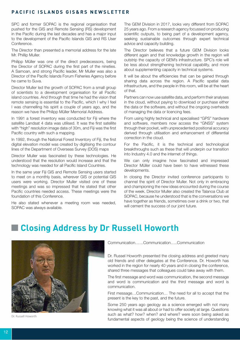
Closing Address by Dr Russell HoworthCommunication……Communication…..Communication
Dr. Russel Howorth presented the closing address and greeted many old friends and other delegates at the Conference. Dr. Howorth has worked in the region for nearly 40 years and in closing the conference, shared three messages that colleagues could take away with them.
The first message and word was communication, the second message and word is communication and the third message and word is communication.
First message…Communication… The need for all to accept that the present is the key to the past, and the future.
Some 250 years ago geology as a science emerged with not many knowing what it was all about or had to offer society at large. Questions such as what? how? when? and where? were soon being asked as fundamental aspects of geology being the science of understanding
Dr. Russell Howorth

12 13
PACIFIC GIS ANDREMOTE SENSING COUNCIL
our planet Earth. Uniformitarianism thinking communicated by geologists versus catastrophist thinking communicated by the church at the time was an ongoing battle of words for many years before the true value of the geological sciences to society and development emerged.
The second message ….Communication…. The need for us all to accept that ongoing data gathering and sharing to better understand the Earth’s dynamic and cyclical processes that impact our everyday lives is of course essential. Unfortunately that communication link between science and policy has been and still in Dr. Howorth’s view remains weak across the region. Nearly 40 years ago in 1981, Dr. Howorth addressed the SOPAC Governing Council meeting for the first time and concluded with the following recommendation:
SOPAC to develop as soon as possible a high priority programme…to assist countries with the definition of potential erosion situations, acquiring baseline data at a scientific and technical level, training of local personnel in the collection and interpretation of that data, and stimulating planning programmes for development projects which make full use of the data.
During that time we had no choice but to carry out data gathering in the field largely by walking, the use of notebooks, pencils and generally small scale 1 50000 air photos and maps and for sure without computers.
This was a full decade before GIS and RS were to make their debut in the region as was recorded by Phillip Müller in 1993 and whose vision is recorded by the Phillip Müller Memorial Address at the beginning of this annual Conference. Today Phillip and many more would acknowledge how we grossly underestimated the impacts in such a short period of time GIS and RS would have.
And so to the third message…Communication….the need for us all to accept that doing business differently not doing different business is a new norm. Do not forget the Red Flag Law in England in the latter half of the 19th century. The technology in the motor vehicle emerging at the time led to the government of the day to totalling mistrusting the motor vehicle and imposing a Red Flag Law which required a man to carry a red flag in front of every moving motor vehicle. Ignorance is not bliss. The lack of communication between the technologists and the policy makers at the time held up the development of the motor vehicle industry in the UK. Of course there were also hidden agendas at play.
Dr. Howorth, than added and asked ‘are you putting the effort into communicating the benefits of your work to society at large to contribute to sustainable development in the region, promoting economic and social wellbeing, whilst at the same time ensuring protection of the environment?’. If your answer to the question was “that you could do more” then he encouraged that you and your employers find ways to do business differently.
As a final word, Dr. Howorth emphasized that he is confident the new Council will have as a key focus of its work these aspects of communication. As members of the Council, they have a responsibility to return home and foster the intent and purpose of the Council including engaging in better communication. Participants must come back to future Conferences to present concrete actions being taken and thereby demonstrate that progress is indeed being made at all levels to ensure the benefits of GIS and RS are better integrated into the planning for development process.
As a trustee of the Council, Dr. Howorth stated his role means working to ensure that the Council has in place resources to fulfill its role for the benefit of all in the region.
PACIFIC GIS ANDREMOTE SENSING COUNCIL
For more Information
Pacific GIS and Remote Sensing CouncilPostal Address: P.O. Box 3786,
Samabula Post Office Mobile: +679-9920987/ +679-9272462
Phone Landline: +679-3322193Email: [email protected] or [email protected]
http://www.picgisrs.org/www.facebook.com/PacGISConf