KETTLE RIVER RESTORATION AND...
33
KETTLE RIVER RAINBOW TROUT ASSESSMENT AND HABITAT RESTORATION 2008 Prepared by Greg Andrusak, BSc., R.P.Bio. Redfish Consulting Ltd. Nelson, BC December 2008 Prepared for the Ministry of Environment and the Habitat Conservation Trust Foundation
Transcript of KETTLE RIVER RESTORATION AND...

KETTLE RIVER RAINBOW TROUT
ASSESSMENT AND HABITAT RESTORATION
2008
Prepared by
Greg Andrusak, BSc., R.P.Bio. Redfish Consulting Ltd.
Nelson, BC
December 2008
Prepared for the Ministry of Environment
and the
Habitat Conservation Trust Foundation

Kettle River Assessment and Habitat Restoration -2008
EXECUTIVE SUMMARY The Kettle and West Kettle rivers are two large rivers in the Okanagan Region that are capable of providing quality stream angling opportunities. However, various natural and anthropogenic factors have limited the abundance of rainbow trout in much of the Kettle River Basin. Issues such as; water and land practices, available habitat, non-native species introduction, recruitment over-fishing, low seasonal flows and high seasonal temperatures have severely limited rainbow trout abundance. This fisheries assessment and restoration work builds upon a recovery plan for Kettle River rainbow trout which identified rearing habitat as the critical limiting factor for trout production. The current approach attempts to assess the trout population while increasing rearing habitat through addition of large woody debris (LWD) structures in habitats that lack adequate depth and cover to sustain rearing juvenile trout in summer and winter. Overall, the 2008 snorkel surveys conducted on three key index sites on the Kettle River indicate that adult and sub-adult abundances declined in 2008 compared to 2007. It was estimated that in 2008 the Kettle River mainstem supported a mean of 35 trout per km, a substantial decline from an estimated mean of 48 per km in 2007. Much of the decline in 2008 was a result of substantially lower numbers of juvenile trout <20 cm. Interestingly, the sites regulated by catch and release and catch and harvest demonstrated unusual changes in 2008. For example, catchable (> 20 cm) rainbow trout numbers declined more abruptly in the catch and release portions while the catch and harvest sections remained fairly constant. This suggests that e trends in abundance between the mainstem Kettle and the West Kettle are not solely driven by the effects of fishing. It is believed that rainbow trout in this system are strongly influenced by annual variation in river flows and temperature. Elsewhere, fishing regulations alone have been demonstrated to be responsible for recovery of other rainbow trout stocks in BC. The 2008 West Kettle River snorkel surveys indicated a decline in rainbow trout abundance in the treatment sections (LWD restoration) compared to 2007 results. The 2008 trout numbers increased substantially in the control sections compared to the 2007 estimate at the same sites. The 2008 trout densities in the treatment sections supported an average of 204 trout per km compared to 260 trout per km in 2007. In contrast, the control sections experienced a dramatic increase in 2008 (163 trout per km) compared to 2007 (57 trout per km). Despite these results catchable size (>20 cm) rainbow trout in the treatment section demonstrated a slight increase in numbers in 2008. Additionally, whitefish numbers increased in both the treatment and control sections in 2008 compared to 2007. Although the treatment section probably received a proportionally higher amount of fishing pressure, the lower 2008 rainbow trout results are probably best explained by survey observations that deterioration and overall functionality of many of the structures over time has occurred. Some of the structures were observed to be either non functional (in the dry) or only partially wetted. The 2009 survey should confirm whether the 2008 results were an anomaly or whether in fact minor improvements need to be made to the existing structures. Despite these apparent problems trout densities remain higher at the restored sites when compared to the pre-existing condition.
REDFISH CONSULTING LTD.
ii

Kettle River Assessment and Habitat Restoration -2008
In September 2008 a total of 9 LWD structures were constructed on the John Bick (private landowner) property. This work is anticipated to provide an increase in over wintering habitat and critical summer low flow pool refugia for rearing juvenile and adult fish. Some on-site modifications were necessary, but all structures conformed to regulatory approval by Department of Fisheries and Oceans (Fisheries Act), BC Ministry of Environment (Fisheries Act, Water Act), and Coast Guard (Navigable Waters Act). Aside from continuing habitat restoration work it is also becoming apparent that improvements rainbow trout stocks within the Kettle and West Kettle rivers will hinge on mitigating impacts of high seasonal temperatures and extreme low flows.
REDFISH CONSULTING LTD.
iii

Kettle River Assessment and Habitat Restoration -2008
ACKNOWLEDGEMENTS
This report was funded by the Habitat Conservation Trust Foundation (HCTF) and represents a summary of work by numerous people within the Ministry of Environment (MOE) and the public. Tara White (senior fish biologist MOE, Penticton, BC) and Paul Askey (fisheries biologist MOE, Penticton, BC); Pat Slaney (River restoration specialist Vancouver BC)and. Ken Ashley (Limnologist Vancouver BC) are acknowledged for their assistance in snorkel surveys. Thank you to John Bick for assistance during the LWD construction phase. Land-owner, John Bick and family are acknowledged for their generous in-kind contribution and use of their property for delivery of this project. In addition, Pat Slaney, Dale Sebastian and Gerry Oliver are acknowledged for their previous works on the Kettle and West Kettle Rivers which are the base references for this report.
This project is largely funded by the Habitat Conservation Trust Foundation. The Habitat Conservation Trust Foundation was created by an act of the legislature to preserve, restore and enhance key areas of habitat for fish and wildlife throughout British Columbia. Anglers, hunters, trappers and guides contribute to the projects of the Foundation through licence surcharges. Tax deductible donations to assist in the work of the Foundation are also welcomed.
REDFISH CONSULTING LTD.
iv

Kettle River Assessment and Habitat Restoration -2008
TABLE OF CONTENTS
EXECUTIVE SUMMARY ................................................................................................ ii
ACKNOWLEDGEMENTS............................................................................................... iv
INTRODUCTION .............................................................................................................. 1
Objectives ....................................................................................................................... 2
SITE DESCRIPTION ......................................................................................................... 2
Kettle River..................................................................................................................... 2
Site of LWD Placement .................................................................................................. 4
BACKGROUND ................................................................................................................ 5
METHODS ......................................................................................................................... 7
Kettle River Flow Data ................................................................................................... 7
Kettle River Temperature Data....................................................................................... 7
Snorkel Enumeration Surveys......................................................................................... 7
Materials for Construction of LWD................................................................................ 8
Wood and Boulders..................................................................................................... 8
Wire Rope, Clamps and Epoxy ................................................................................... 8
Heavy Equipment ........................................................................................................ 8
Tools and Other Field Equipment............................................................................... 8
RESULTS ........................................................................................................................... 9
Kettle and West Kettle Rivers Flow Data....................................................................... 9
Kettle River Temperature Data....................................................................................... 9
2008 Snorkel Enumeration Surveys.............................................................................. 12
Kettle River ............................................................................................................... 12
West Kettle River....................................................................................................... 13
Construction of LWD ................................................................................................... 18
DISCUSSION................................................................................................................... 20
REFERENCES ................................................................................................................. 22
APPENDIX A. Photos ............................................................................................... 24
REDFISH CONSULTING LTD.
v
Kettle River Assessment and Habitat Restoration -2008
LIST OF FIGURES
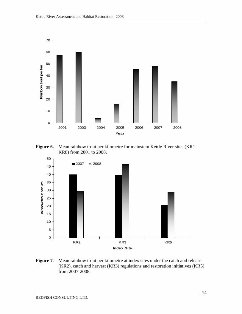
Figure 1. Kettle River Basin map with established snorkel index sites. ........................ 3
Figure 2. Site of LWD placement on Kettle River in 2008 in red and 2007 in black. ... 4
Figure 3. Mean monthly discharge (m3/s) for 2007 and 2008 for the Kettle River 10
Figure 4. Seasonal summer mean monthly discharge (m3/s) for 2007 and 2008 for the Kettle River............................................................................................................... 11
Figure 5. Mean, maximum and minimum monthly discharge (m3/s) for the West Kettle River at Westbridge BC, recorded since 1914 to 2006............................................. 12
Figure 6. Mean rainbow trout per kilometre for mainstem Kettle River sites (KR1-KR8) from 2001 to 2008........................................................................................... 14
Figure 7. Mean rainbow trout per kilometre at index sites under the catch and release (KR2), catch and harvest (KR3) regulations and restoration initiatives (KR5) from 2007-2008. ....................................................................................................... 14
Figure 8. Rainbow trout abundance at key index sites (2001-2008) before and after catch and release (KR2) and catch and harvest (KR3) regulations were imposed in 2004. 15
Figure 9. Rainbow trout abundance from 2007 to 2008 in the restoration site (KR5), including a sub-site that contains a 600 m highly complex side channel ................. 16
Figure 10. Rainbow trout per km in response to in-stream restoration (treatment section) on the West Kettle River, 1997 to 2008. ..................................................... 16
Figure 11. Catchable (> 20 cm) rainbow trout per km in response to in-stream restoration (treatment section) on the West Kettle River, 1997 to 2008. ................. 17
Figure 12. Whitefish per km in response to in-stream restoration (treatment section) on the West Kettle River, 1997 to 2008.................................................................... 17
Figure 13. Triangular ramp-log structure design........................................................ 19
LIST OF TABLES
Table 1. Mean rainbow trout per kilometre at key index sites on the Kettle River. ... 13
REDFISH CONSULTING LTD.
vi

Kettle River Assessment and Habitat Restoration -2008
LIST OF PHOTOS
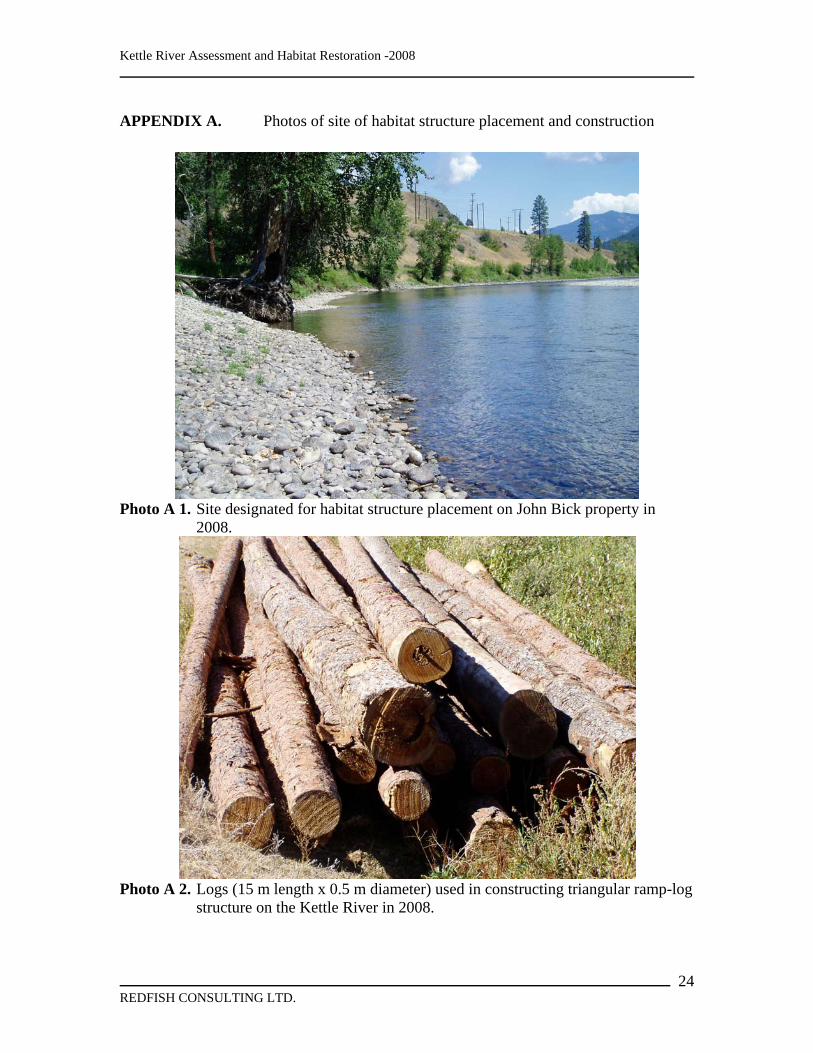
Photo A 1. Site designated for habitat structure placement on John Bick property in 2008. 24
Photo A 2. Logs (15 m length x 0.5 m diameter) used in constructing triangular ramp-log structure on the Kettle River in 2008.................................................................. 24
Photo A 3. Boulders (~0.3 m3 diameter) used in construction of triangular ramp-log structure on the Kettle River in 2008. ....................................................................... 25
Photo A 4. Spyder-hoe excavator used in constructing triangular ramp-log structure on the Kettle River in 2008. ...................................................................................... 25
Photo A 5. Site after completion of habitat structure placement adjacent to John Bick property in 2008. ....................................................................................................... 26
Photo A 6. Site after completion of habitat structure placement adjacent to John Bick property in 2008. ....................................................................................................... 26
REDFISH CONSULTING LTD.
vii

Kettle River Assessment and Habitat Restoration -2008
INTRODUCTION The Kettle and West Kettle rivers provide some of the few river fishing opportunities in the Okanagan Region. The fishery is focused on wild stocks of fluvial rainbow trout (Oncorhynchus mykiss), that can attain sizes in excess of 50 cm, and mountain whitefish (Prosopium williamsoni). During the last two decades the quality of these system’s fisheries have deteriorated, evidently due to low abundance and small size of rainbow trout (Sebastian 1989 and Godin 1994). In recent years, sustainability of the fishery, through further restrictive regulations alone has proven to be ineffective (Oliver 2001 and 2002; Andrusak 2006). Various natural and anthropogenic factors have limited the abundance of rainbow trout in much of the Kettle River Basin. Often fish populations can be depressed as a result of exceedingly high summer temperatures and low summer flows that diminish the availability of critical habitat. The future of rainbow trout within the much of the Kettle River Basin will rely on mitigating (or somehow reducing) impacts of low seasonal flows and high seasonal temperatures. The current approach outlined in this report has been to mitigate through creation of more summer low flow refuge habitat. Concurrent with recent river restoration work on the Kettle and West Kettle rivers, there has been a long-term monitoring through annual snorkel surveys to determine trends in trout abundance. . Snorkel surveys on these large streams provide a relatively inexpensive cost effective index on population trends, species composition, distribution and abundance. Importantly, the survey results also assist in assessing the effectiveness of different fishing regulations in place on these systems. As an example, monitoring of regulations (catch and release and catch and harvest) implemented in 2004 on the Kettle River indicated that declining fish numbers were not solely related to over-exploitation. Wilson (2005) attributed the decline in trout abundance to other environmental factors such as high temperatures and low seasonal flows. Although rainbow trout numbers remain low, juvenile trout data obtained from the primary tributaries showed that there were sufficient fry and parr numbers to support higher adult numbers (Andrusak 2006). Based on this juvenile trout survey it was concluded that increasing adult trout numbers could be best achieved through habitat restoration, on the mainstem Kettle River (Slaney 2006). Construction of complex structures in 2007 and 2008 are expected to provide quality rearing habitat that will contribute to the long term goal of restoring rainbow trout abundance in the Kettle River. Prescribed “large woody debris” (LWD) structures are anticipated to increase over wintering habitat and summer low flow pool refugia for rearing parr and adult fish while maintaining the biological and structural functionality over time. This supposition is supported by the high densities of trout found in LWD structures placed in the West Kettle River over a decade ago (Slaney et al. 2001). This report summarizes results of the annual snorkel surveys conducted on the Kettle and West Kettle Rivers since 2001. It is important to note that this project also builds upon a recovery plan for Kettle River rainbow trout which identified habitat as the critical
REDFISH CONSULTING LTD.
1

Kettle River Assessment and Habitat Restoration -2008
limiting factor for production. Thus the report also describes the implementation and construction of restorative measures on the Kettle River in 2008 designed from a Fish Habitat Assessment Procedure (FHAP) of the Watershed Restoration Program (WRP) (Johnston and Slaney 1996) detailed in Slaney (2006).,
Objectives • Summarize the 2008 snorkel survey estimates reaches of the Kettle and West
Kettle Rivers • Compare 2008 annual snorkel survey estimates with surveys conducted since
2001. • Summarize the construction of 9 prescribed lateral triangle LWD structures in the
Kettle River near Midway, BC
SITE DESCRIPTION
Kettle River The Kettle River flows generally in a north - south direction between the Okanagan Highlands and the Monashee mountain range in southeast British Columbia (Fig. 1). The Canadian portion of the watershed area is 8,150 km2. The river flows across the U.S. border at Midway, crosses back into Canada near Grand Forks, before crossing again near Christina Lake and ultimately flowing into the Columbia River. Major tributaries include the West Kettle River and Granby River. The area of focus for this project proposal is the mainstem Kettle River from Cascade Falls (adjacent to the town of Christina Lake) upstream to the confluence with Rendell Creek in the Christian Valley including Rock Creek, Myers Creek and Boundary Creek tributaries. The West Kettle River also flows in a north-south direction between the Okanagan Highlands and the Monashee mountain range. Conkle Creek, a major lake-headed tributary to the West Kettle River, is also a stream of focus for this particular study, The West Kettle River flows ~ 44 km where it converges with the Kettle River near Westbridge, BC. The total watershed area for the West Kettle River is 1870 km2. The Kettle River upstream of Cascade Falls and the West Kettle River supports rainbow trout, mountain whitefish, eastern brook trout and a number of non-game species. These rivers provide one of the few quality rainbow trout river fisheries in the Okanagan Region, and sport fishing on the system is very popular given the area’s natural setting and ease of access off of Highway 33, Highway 3 and the Trans Canada Trail. Seven snorkel survey index sites have been established throughout the Kettle valley (Fig. 1). In 2008 the seventh site (KR 7) was not sampled.
REDFISH CONSULTING LTD.
2

Kettle River Assessment and Habitat Restoration -2008
Figure 1. Kettle River Basin map with established snorkel index sites.
REDFISH CONSULTING LTD.
3

Kettle River Assessment and Habitat Restoration -2008
Site of LWD Placement Habitat structures, as prescribed by Slaney (2006), were located within a low gradient portion of the mid-Kettle River near Midway, BC (Fig 2). This section of the river is located within a snorkel survey index site (KR5).
Figure 2. Site of LWD placement on Kettle River in 2008 in red and 2007 in black.
REDFISH CONSULTING LTD.
4

Kettle River Assessment and Habitat Restoration -2008
BACKGROUND The Kettle Valley was initially developed due to mining interests in the late 1890s and early 1900s, particularly in the Beaverdell area. The C.P.R. railway was built in the main valley in 1912 to serve mining and logging interests (Anon. 1973). Today the economy is largely driven by logging, ranching and recreation with some very limited mining activity. River fishing is a form of recreation that has been quite popular given the ease of access provided by Highways 3 and 97. The West Kettle and main Kettle rivers are very attractive looking as they are low gradient, accessible meandering systems that simply look “fishy”. Evidently some good fishing was historically available but actual documentation could not be easily found. McPhail and Carveth (1992) indicate twenty seven fish species have been documented as present in the Kettle River drainage with rainbow trout (Oncorhynchus mykiss), brook trout (Salvelinus fontinalis), whitefish (Prosopium williamsoni) and brown trout (Salmo trutta) being the primary sport fish species. Primary non-game species include; sculpins (Cottus spp.), suckers (Catostamus spp.) and a variety of cyprinids (Family Cyprinidae). In the early 1970s the Fish and Wildlife Branch undertook the first formal assessment of the Kettle River and West Kettle River fishery (Anon 1973). The most important spawning streams were identified, low flows were observed in the main river and some options for headwater storage were identified (Bull 1974). Some limited creel census data were obtained from the West Kettle River (Beaverdell-Westbridge) that demonstrated high CPUE (1.8 fish per hour) for small trout (25 cm or less). It wasn’t until the late 1980s that some quantification of fish values was made by Sebastian (1989). Juvenile and adults were sampled by a combination of electrofishing and snorkel surveys. Snorkel surveys suggested that adult size fish were few and far between and Sebastian concluded that habitat was limited due to a combination of low flows and lack of cover. As well, Sebastian applied the Binns production model (Binns 1982) to determine that adult fish were < 20% of theoretical capacity. Lack of older fish led Sebastian to the conclusion that over fishing was also part of the reason adult numbers were so low. Growing concerns about the lack of good trout fishing in the Kettle River, substantiated by Sebastian (1989), lead fisheries managers to experimentally stock the river with two river-resident stocks and catchable domestics. In 1989 and 1999 adult size trout were introduced and assessments of these stockings were carried out by Godin et al. (1994). This was by no means the first time trout had been introduced into the system. Stocking records indicate that rainbow trout eggs or fry had been common from as early as 1914 through to the early 1950s. Results of the experimental stockings were at best mixed. All stocks provided increased first summer fishing opportunities but over winter survival, especially of the wild stocks, were very low. The conclusion from Godin et al. (1994) was that any river stocking for purposes of carry-over to a second season was not worthwhile and increased effort due to stocking adversely impacted the wild stock. The stocking program ceased after 1994, except for small releases of domestic catchables in high access sites. This practice also ceased due to continued concerns over conservation of wild fish.
REDFISH CONSULTING LTD.
5

Kettle River Assessment and Habitat Restoration -2008
An excellent over-view of the status of rainbow trout in the Kettle Basin was provided by Oliver (2001). Hydrological and temperature data were reviewed and fishery data was summarized. Oliver also concluded that the rainbow population was below carrying capacity and that few catchable size fish were available to the anglers. Low stock productivity was linked to over fishing and habitat limitations, especially high summer temperatures and very low summer flows. He therefore recommended the placement of LWD to create/restore habitat that would increase over wintering habitat and summer low flow pool refugia for rearing and adult fish. The paucity of spawning age fish observed by Sebastian and later by Oliver has been attributed to over-harvest and recommendations by Oliver (2002) for catch-and-release regulations for specific areas of the watershed were implemented in April 2004. To evaluate the effectiveness of these new regulations, provincial fisheries staff initiated annual snorkel evaluations in 2003 to compare abundance and size structure of rainbow trout in a newly established 4 km catch-and-release section and an existing 4 km catch-and-harvest section of the Kettle River. Despite these new regulations, the number of trout per km for this section of the river decreased from 110 per kilometre (2001) to 64 per kilometre (2003) and 1.7 per kilometre (2004). A similar decline was noted in the 4 km section where catch and harvest was permitted. Although early in the effectiveness monitoring, early indications demonstrated that the observed decline in 2004 could not purely be related to over fishing and other factors were involved in regulating the population (Wilson 2005). Over a decade ago Slaney et al. (2001) chose the West Kettle River as a demonstration site for development of pool forming LWD structures. A total of 19 structures were built in a 4 km section of the river. Trout abundance in the treated section increased from 6 fish > 10 cm per km to 62 per km. The control also increased from 2 fish per km to 28 per km but clearly far more fish were found in the newly created structures and pools. In 2000 the numbers had increased to 232 per km in the restored area compared to only 68per km in the control section. These results clearly demonstrated that properly designed structures can greatly increase refuge habitat that is required by rainbow trout in the West Kettle River. More recently, a juvenile production survey revealed that tributary recruitment was not a factor limiting the rainbow trout population in the Kettle and West Kettle rivers (Andrusak 2006). Juvenile densities (ages 0-2) were consistently high (> 0.4 rainbow trout per m²) for most of the tributaries sampled. Therefore, if the proportion of ages 0-2 are true representations of the age structure in these tributaries, then older age groups (> age 2) must move to the main river to rear. Increasing abundance, through habitat restoration, of older 2+ parr would be highly beneficial for increasing the number of adult trout in the mainstem of the Kettle River (Slaney 2006).
REDFISH CONSULTING LTD.
6

Kettle River Assessment and Habitat Restoration -2008
METHODS
Kettle River Flow Data Kettle River flow data was obtained from USGS Water Resources (http://water.usgs.gov/) from two stations at Ferry, WA (Station 12401500) and Laurier, WA (Station 12404500). Ferry and Laurier are located upstream of the Canada/US border at Midway and Cascade, BC, respectively. Data on mean daily, mean monthly, and mean annual discharge (MAD) have been recorded since 1929. West Kettle River flow data is collected by an Environment Canada (http:///www.wsc.ec.gc.ca) hydrometric station (08NN003) located at Westbridge, BC. Data on mean daily and monthly increments have been collected since January 1914 to December 2006.
Kettle River Temperature Data An Onset StowAwayTM TidbitTM data logger was installed in the mid-Kettle River, adjacent to the Pope and Talbot mill near Midway, BC. The logger was initially installed on July 8, 2006 and has recorded water temperature every 30 minutes continuously to the present. Each logger was attached to a small light-weight cable that was installed to a piece of LWD or small woody vegetation in a shaded area in a minimum depth of 20 cm. Temperature records were periodically downloaded to a laptop computer and stored in Excel files.
Snorkel Enumeration Surveys Except for 2002, snorkel surveys have been conducted on the Kettle River since 2001 in July and September. Index sites, for monitoring trends in fish populations, were established by Oliver (2002) from the upper Kettle River extending down to the lower Kettle River. More specifically, index sites include KR 1 in the upper river reach through to KR 7 in the lower river below Grand Forks, BC (Fig. 1). Snorkel surveys have been conducted using a combination of 2-5 divers covering equidistant lanes spanning the entire wetted width of the river. Swimmers remained in standardized counting lanes as described in Slaney and Martin (1987). Since 2001, replicating individual sites has varied along with the number of divers and distances in some years. As a result, the mean of these counts represent indices of abundance that provide information on population trends. In 2004, catch and release regulations were implemented on portions of the Kettle River including index sites KR 2 and KR 7 while remaining index sites KR 1, KR 3-KR 6. ,
REDFISH CONSULTING LTD.
7

Kettle River Assessment and Habitat Restoration -2008
retained catch and harvest opportunities. In 2008, KR5 was added as a monitoring site to collect information on fish abundance prior to placement of LWD habitat structures. As well, a large complex side channel ~600 m in length was surveyed within the KR5 site in 2008 by two divers. Similarly, snorkel surveys have been conducted on the West Kettle River since 1997. Annual surveys have been conducted to measure the response of rainbow trout and whitefish abundance to in-stream restoration, primarily the response to additions of large woody debris (LWD). Annual surveys are conducted on index sites within a control section and a treatment section. Details of work and early responses are summarized by Slaney et al. (2001).
Materials for Construction of LWD
Wood and Boulders The 2008 project required a total of ~40 large logs, consisting of larch and fir, and ~100 large boulders to construct 9 LWD habitat structures. Of this total, the logs ranged from 14-15 m in length and from 0.5m -1.0m in diameter, which were delivered by Pope and Talbot near Midway, BC. Boulders were delivered from a MoT quarry located ~80 km away from the construction site at Trapping Creek. Boulders ranged in size from 0.25m – 0.6 m in diameter.
Wire Rope, Clamps and Epoxy Approximately 1000 lineal feet of ½ inch galvanized steel core wire rope cable and 50 galvanized Crosby type steel U-clamps were used to secure the LWD to boulders during the 2008 restoration project. Hilti RE-500 and RE-150 epoxy was used to secure the ½ inch galvanized cable through a pre-drilled hole in the ballast boulders to the LWD.
Heavy Equipment All instream machine work was conducted with “spyder” excavator (Cat E120B) that was serviced with biodegradable hydraulic oil. The barren flood plain also allowed easy access for the excavator to deliver boulders and large LWD directly to the restoration sites from the staging area. As well, a small excavator (Cat E120B) was used to load materials into 2 dump trucks at the MoT quarry near Trapping Creek.
Tools and Other Field Equipment A Hilti TE 75 hammer drill, using a 9/16 inch bit, was used to drill holes into the boulders to epoxy and secure cable ends. A Dewalt reversible electric drill, using a ¾ auger bit, was used to drill holes through the logs. Two specially designed, heavy-duty shank auger
REDFISH CONSULTING LTD.
8

Kettle River Assessment and Habitat Restoration -2008
bits with 18-inch extensions were necessary to allow for drilling through larger diameter logs and logs submerged under water. All electric tools were powered by a 2000-watt Honda generator, equipped with a ground fault interrupter (GFI) and a grounding strap, was used with a grounded heavy-duty extension cord. Other tools and equipment required to construct the instream structures included; chainsaws, wrenches, wire hole cleaning brushes, hand air pumps, hand water pumps, sledge hammers, and cable cutters.
RESULTS
Kettle and West Kettle Rivers Flow Data Monthly flow data from the USGS Water Resources survey stations at Ferry and Laurier, WA indicated that Kettle River peak flows occurred in late May to early June, 2008, well above levels observed in 2007 (Figs. 3). However, mean monthly summer flows in 2008 (July-October), starting in July, were well below the mean value for 79 years of data collected at both stations, similar to 2007 (Fig. 4). The 2008 summer flows were well below the normal flow regime; slightly above the 20% percentile of for both the middle and lower Kettle River. The discharge pattern in 2008 was consistent with records for flow data (m3/s) dating back to 1928-1929. Although not complete for 2008, mean annual discharge (MAD) to late November was estimated at 36 m3/s and 74 m3/s for Ferry and Laurier, WA, respectively. The mean annual discharge in 2008 in the upper river was above the MAD observed in 2007, however, this was not consistent in the lower river, where the opposite occurred. Importantly, the historical average since 1929 has been 43 m3/s and 83 m3/s for Ferry and Laurier, WA, respectively. Although not current, monthly flow data recorded from 1914 to 2006 on the West Kettle River provides some insight into an average flow year and the range of variability. Similar to the Kettle River, historic (1914-2006) monthly flow data from the Environment Canada water survey stations at Westbridge, BC illustrates that the West Kettle River typically peaks during a period between May to June (Fig. 5). Importantly, the historical discharge recorded on the West Kettle River indicates an annual mean of ~14 m3/s, almost 3 times less than the upper Kettle River.
Kettle River Temperature Data In the spring of 2008, it was discovered that the temperature logger that was installed in 2006 was missing. This was most likely a result of the break-up and the effect of scouring during the ice-off event on the Kettle River. Consequently, a new logger was installed in September 2008 which was downloaded at the time of this report writing. As well, no temperature data was recorded on the West Kettle River in 2008. However, Andrusak (2006 and 2007) and Oliver (2002) provide some historic temperature profiles on these systems.
REDFISH CONSULTING LTD.
9

Kettle River Assessment and Habitat Restoration -2008
0
50
100
150
200
250
300
350
400
Jan Feb Mar Apr May Jun Jul Aug Sep Oct Nov Dec
Month
Mea
n M
onth
ly D
isch
arge
(m3 /s
)2007Mean since 19282008
0
50
100
150
200
250
300
350
400
Jan Feb Mar Apr May Jun Jul Aug Sep Oct Nov Dec
Month
Mea
n M
onth
ly D
isch
arge
(m3 /s
) 2007Mean since 19292008
Figure 3. Mean monthly discharge (m3/s) for 2007 and 2008 for Ferry (upper) and
Laurier (lower), WA, recorded since 1928-29. The Ferry station represents flows in the upper Kettle River near Midway BC, while Laurier represents flows in the lower portion of the river near Grand Forks BC.
REDFISH CONSULTING LTD.
10

Kettle River Assessment and Habitat Restoration -2008
0
10
20
30
40
50
60
70
80
Jul Aug Sep
Month
Mea
n M
onth
ly D
isch
arge
(m3 /s
)2007Mean since 19282008
0
10
20
30
40
50
60
70
80
Jul Aug Sep
Month
Mea
n M
onth
ly D
isch
arge
(m3 /s
) 2007Mean since 19292008
Figure 4. Seasonal summer mean monthly discharge (m3/s) for 2007 and 2008 for
Ferry (upper) and Laurier (lower), WA, recorded since 1928-29. The Ferry station represents flows in the upper Kettle River near Midway BC, while Laurier represents flows in the lower portion of the river near Grand Forks BC.
REDFISH CONSULTING LTD.
11

Kettle River Assessment and Habitat Restoration -2008
0
20
40
60
80
100
120
Jan Feb Mar Apr May Jun Jul Aug Sep Oct Nov Dec
Month
Mon
thly
Dis
char
ge (m
3 /s)
Max
Mean
Min
Figure 5. Mean, maximum and minimum monthly discharge (m3/s) for the West Kettle
River at Westbridge BC, recorded since 1914 to 2006.
2008 Snorkel Enumeration Surveys
Kettle River Single pass, non-repeatable, snorkel surveys were conducted on the Kettle River on three key index sites (KR2, KR3 and KR5) during July 24 and 25, 2008. Based on these three index sites, average trout density (trout per km) was lower in 2008 at 35 trout per km compared to 48 trout per km in 2007 (Fig. 6). Nonetheless, the 2008 estimate remains much higher than the 2004 and 2005 estimates. Trout density at the catch and release site (KR2) was lower in 2008 (30 trout/km) compared to 2007 (40 trout/km); oddly enough there were more trout in the catch and harvest section (KR3) than in the non harvest section (Fig. 7; Table 1). Average trout densities at KR3 and KR 5 increased in 2008 compared to 2007 (Fig. 7). Analysis of size groups within each site provides a partial explanation for this apparent anomaly. Analysis of size classes of trout suggests that much of the decline in KR2 in 2008 was a result of lower numbers of smaller (< 20 cm) juvenile recruits. This could result from lower recruitment and or competition for space with larger sized trout. In comparing KR2 and KR3 over the past three years, catchable (> 20 cm) rainbow trout numbers have
REDFISH CONSULTING LTD.
12

Kettle River Assessment and Habitat Restoration -2008
remained relatively stable within the catch and harvest portion (KR3) while the catch and release portion (KR2) has declined more precipitously (Fig. 8). This does raise the question of high hooking mortality. The data also indicates that rainbow trout > 40 cm have increased quite dramatically at KR3 in 2008, while at KR2 there was a decline in this size group. At the restoration site (KR5), densities in the mainstem river section increased from 20 trout per km in 2007 to 29 trout per km in 2008 (Fig. 9; Table 1). However, theses densities were relatively low compared to other mainstem sites on the Kettle River. As well, the ~600 m site side channel within KR5 was comprised of highly complex habitat (LWD and deep pool) also indicated a slight decline in 2008 compared to 2007. Although there was an overall decline in numbers in the side channel, densities were ~2.5 times higher than its mainstem counterpart in 2008 (Table 1). The 2008 survey conducted at KR5 provides the necessary background data on fish abundances prior to installation of habitat structures. Table 1. Mean rainbow trout per kilometre at key index sites under regulations (catch
and release, catch and harvest) imposed in 2004 on the Kettle River.
Catch and Release Catch and Harvest Year KR2 KR7 KR3 KR5 KR5 side channel 2004 17 n/a n/a n/a n/a 2005 8 26 19 n/a n/a 2006 36 n/a 60 n/a n/a 2007 40 92 40 20 93 2008 30 n/a 46 29 80
West Kettle River Trout densities utilizing LWD structures on the West Kettle River constructed by Slaney et al. (2001) have been monitored annually as a part of a long term assessment program. Single pass, non-repeatable, snorkel surveys were conducted within the 2.3 km treatment and 1 km control sections in the West Kettle River on July 23, 2008. Rainbow trout abundance within the treatment section showed a decline from 260 trout per km in 2007 to 204 trout per km in 2008 (Fig. 10). Although the densities have decreased in the last two years they remain much higher than the pre-treatment years (1997-1998). Furthermore even though overall rainbow trout numbers have declined in the treatment section, catchable (> 20 cm) increased slightly in 2008 compared to 2007 (Fig. 11). In 2008 the control section survey indicated a dramatic increase in rainbow trout densities from 57 trout per km in 2007 to 163 trout per km in 2008. However, the 2008 density estimate for the control section was still lower than the treatment section. Whitefish abundance substantially increased in 2008 within both the treatment and control sections in 2008 compared to 2007 (Fig. 12). It was estimated that the treatment section supported an average of 68 whitefish per km compared to an average of 50 whitefish per km the control section in 2008. The 2008 whitefish density in the treatment site is the highest estimate in 12 survey years.
REDFISH CONSULTING LTD.
13
Kettle River Assessment and Habitat Restoration -2008
0
10
20
30
40
50
60
70
2001 2003 2004 2005 2006 2007 2008
Year
Rai
nbow
trou
t per
km
Figure 6. Mean rainbow trout per kilometre for mainstem Kettle River sites (KR1-KR8) from 2001 to 2008.
0
5
10
15
20
25
30
35
40
45
50
KR2 KR3 KR5
Index Site
Rain
bow
trou
t per
km
2007 2008
Figure 7. Mean rainbow trout per kilometre at index sites under the catch and release
(KR2), catch and harvest (KR3) regulations and restoration initiatives (KR5) from 2007-2008.
REDFISH CONSULTING LTD.
14

Kettle River Assessment and Habitat Restoration -2008
Index Site-KR2
0
5
10
15
20
25
30
0-10 10-20 20-30 30-40 40+
Size (cm)
Num
ber o
f rai
nbow
trou
t
2001200320042005200620072008
Index Site-KR3
0
5
10
15
20
25
30
0-10 10-20 20-30 30-40 40+
Size (cm)
Num
ber o
f rai
nbow
trou
t 2001200320042005200620072008
Figure 8. Rainbow trout abundance at key index sites (2001-2008) before and after
catch and release (KR2) and catch and harvest (KR3) regulations were imposed in 2004.
REDFISH CONSULTING LTD.
15

Kettle River Assessment and Habitat Restoration -2008
Index Site-KR5
0
5
10
15
20
25
30
35
40
0-10 10-20 20-30 30-40 40+
Size (cm)
Num
ber o
f rai
nbow
trou
t2007 mainstem
2007 Side channel
2008 mainstem
2008 Side channel
Figure 9. Rainbow trout abundance from 2007 to 2008 in the restoration site (KR5),
including a sub-site that contains a 600 m highly complex side channel
0
100
200
300
400
500
600
700
1997 1998 1999 2000 2001 2002 2003 2004 2005 2006 2007 2008
Year
Rai
nbow
trou
t per
km
ControlTreatment
Figure 10. Rainbow trout per km in response to in-stream restoration (treatment section)
on the West Kettle River, 1997 to 2008.
REDFISH CONSULTING LTD.
16

Kettle River Assessment and Habitat Restoration -2008
0
40
80
120
160
200
1997 1998 1999 2000 2001 2002 2003 2004 2005 2006 2007 2008
Year
# R
ainb
ow tr
out >
20 c
m p
er k
m
Figure 11. Catchable (> 20 cm) rainbow trout per km in response to in-stream
restoration (treatment section) on the West Kettle River, 1997 to 2008.
0
10
20
30
40
50
60
70
80
1997 1998 1999 2000 2001 2002 2003 2004 2005 2006 2007 2008
Year
Mou
ntai
n w
hite
fish
per k
m
ControlTreatment
Figure 12. Whitefish per km in response to in-stream restoration (treatment section) on
the West Kettle River, 1997 to 2008.
REDFISH CONSULTING LTD.
17

Kettle River Assessment and Habitat Restoration -2008
Construction of LWD Lack of suitable construction material onsite required the hauling and marshalling of rock and woody materials prior to the construction that began on September 2, 2008. . The primary large wood structure constructed was the lateral triangle design owing to its high stability (Fig. 12; Slaney et al. 1997; Wilson et al. 2002). In total, 9 LWD structures were constructed on the John Bick (private landowner) property (see Photos in Appendix 1). Some on-site modifications were necessary, but all structure conformed to regulatory approval by Department of Fisheries and Oceans (Fisheries Act), BC Ministry of Environment (Fisheries Act, Water Act), and Coast Guard (Navigable Waters Act) (Fig. 12). Habitat structure placement was focused on LWD structures in riffles, glides and shallow pools which lacked adequate depth and cover for sustaining juvenile trout in both summer and winter. At each site, wood structures were ballasted with boulders using the epoxy attachment technique (Slaney and Zaldokas 1997 and Melville 1997). Boulders were drilled using 9/16 inch bits to accommodate ½ inch galvanized cable. Boulder ballasting requirements were calculated using methods provided by D’Aoust and Millar (2000).
REDFISH CONSULTING LTD.
18

Kettle River Assessment and Habitat Restoration -2008
Figure 13. Navigable waters design concept: triangular ramp-log structure designed to
restore trout habitat and to trap driftwood and, if needed, to protect/stabilize stream banks. (Large buried ballast boulders are required at the top of the bank where riparian trees are likely small, or <30 cm in basal diameter.)
REDFISH CONSULTING LTD.
19

Kettle River Assessment and Habitat Restoration -2008
DISCUSSION While the Kettle and West Kettle rivers are two large rivers in the Okanagan Region capable of providing quality stream angling, the future of their sustainability as a recreational fishery is highly uncertain due to the cumulative impacts on the rivers’ habitat. As with many rivers within the Pacific Northwest, linear development (agriculture, logging and mining) has had a profound effect upon the natural river ecosystem. Consequently, fish habitat in much of the Kettle River Basin, primarily in the lower reaches, is considered to be poor to fair in quality due to these past disturbances. Furthermore, the ability to mitigate many of these past disturbances is fraught with increasing environmental changes on a global scale. Higher seasonal temperatures concurrent with low seasonal flows continue to plague the Kettle River Basin and its fish populations. Importantly, the future status of fish populations within the Kettle River Basin relies on mitigating impacts of low seasonal flows and high seasonal temperatures within the mainstem of the Kettle River. Historical practices of riparian logging or clearing have resulted in losses of woody accumulations along river banks, adversely affecting the natural morphology of the channel and its complexity (Koski 1992). Moreover, removal of riparian functions can accelerate stream bank erosion (Murphy 1995), and such activities can greatly affect natural geomorphology to the degree that there are significant losses of fish habitat (Slaney and Zaldokas 1997). Under these degraded conditions, habitat restoration is frequently needed to replace lost large wood and other natural shelter features (Slaney et al. 1997, Ward 1997, Roni et al. 2002). Restorative measures, through placement of LWD, are expected to provide an increase in over wintering habitat and critical summer low flow pool refugia for rearing juvenile and adult fish in the Kettle River. Once again, the Kettle River Basin experienced extreme low summer flows in 2008. The problematic trend in low summer flows, especially for the summer months (July-September), is highly apparent as mean monthly flows have declined well below the 79 year average since 1928-29. Exacerbated by decreased summer flows, temperature data indicates an increase in mean summer temperature in recent years, with maximum daily temperatures often exceeding 24°C by the mid-July. Oliver (2002) also demonstrated that these temperature maximums are more likely pronounced in the lower portion compared to the middle and upper portions of the Kettle River. As in past years, the temperature optimum for growth has been continually exceeded and that prolonged exposure to these high temperatures will have a cumulative negative effect resulting in higher mortality and reduced abundance (McCullough 1999, Dunham et al. 2003). This idea was confirmed by a fish kill on the lower portion of the river near Christina Lake in 2006 where maximum daily temperatures exceeded 26°C (on file MOE Penticton, BC). In general, these cumulative impacts of low flows and high temperatures are believed to have depressed trout abundance in the Kettle River.
REDFISH CONSULTING LTD.
20

Kettle River Assessment and Habitat Restoration -2008
In 2008, snorkel surveys conducted on three key index sites on the Kettle River indicate that the adult and sub-adult abundances have declined in 2008 compared to 2007. It was estimated that in 2008 the Kettle River mainstem was supporting a mean of 35 trout per km, a substantial decline from a mean of 48 per km in 2007. While much of the decline was a result of substantially lower numbers of juvenile trout <20 cm, sites regulated by catch and release and catch and harvest demonstrated unusual trends in 2008. For example, catchable (> 20 cm) rainbow trout numbers declined more abruptly in the catch and release portions while the catch and harvest sections remained fairly constant, suggesting that the correlation in abundance trends between the mainstem Kettle and the West Kettle are not purely due to regulation changes. Rather, population abundance appears to also be influence by regional flow and temperature trends imposed by annual climatic variation. Although, similar responses to sport fishery regulations have demonstrated recoveries of other rainbow trout stocks in BC (Martin and Bell 1984; Slaney 1986). The 2008 West Kettle River snorkel surveys indicated a decline in abundance of rainbow trout in the treatment sections (LWD restoration), while the control section demonstrated a substantial increase. It was estimated that the treatment sections supported an average of 204 trout per km in 2008 compared to an average of 260 trout per km in 2007. In contrast, the control sections observed a dramatic increase in 2008 (163 trout per km) compared to 2006 (57 trout per km). However, catchable (>20 cm) rainbow trout in the treatment section demonstrated a slight increase in numbers in 2008. Additionally, while the rainbow trout data was more variable, whitefish numbers increased in both the treatment and control in 2008. Although the treatment section receives a proportionally higher amount of fishing pressure, the rainbow trout trend observed could also be related to the deterioration and overall functionality of many of the structures over time (pers. comm. author). A number of structures were observed to not be functioning (in the dry) as originally intended to support fish habitat. Additionally, it was noted that the control section had received some small, but highly populated, natural woody debris structures. The 2009 survey should assist in our understanding of these factors related to the decline within the treatment section of the West Kettle River. In general, restoration of the mainstem sections of the Kettle River, using LWD, is considered to be a good strategy for improving the rivers’ trout population and builds upon a recovery plan, detailed in Slaney (2006), for Kettle River rainbow trout which identified habitat limitation as a major factor in the low productivity of this stock (Oliver 2002). The future status of rainbow trout stocks relies on mitigating impacts of low seasonal flows and high seasonal temperatures within the mainstem of the Kettle River. Increasing the availability of low flow summer habitat for older 1+ and 2+ parr should be highly beneficial to the production of adult trout in the mainstem of the river. The West Kettle River work provides an excellent example of the performance of such restorative measures suffused by similar issues (Slaney et al. 2001). Careful management through fishing regulations combined with these restorative measures should provide the basis for the recovery Kettle River rainbow trout.
REDFISH CONSULTING LTD.
21
Kettle River Assessment and Habitat Restoration -2008
REFERENCES Andrusak, G.A. 2006. Kettle River, West Kettle River and Tributary Rainbow Trout
Assessment-2006. Prepared for the BC Ministry of Environment, Penticton, BC. Pp 54+
Bull, C.J. 1974. Kettle River Water Survey Fishery - Water Use Conflicts in West Kettle
River Watershed. South Central BC. DRAFT. Fisheries Project Report No. 1035 Ministry of Environment, BC Government.
D’Aoust, S. G. and R. G. Millar. 2000. Stability of ballasted woody debris habitat
structures. Journal of Hydraulic Engineering 126:810-817. Godin, T.I., P.A. Slaney and D.R. Smith. 1994. Assessments of Resident Rainbow Trout
Populations and Stocking Evaluations in Four British Columbia Rivers. Ministry of Environment, Lands and Parks Fisheries Research Section, UBC. Fisheries Management Report. No.109. p18.
Johnston, N.T. and P. A. Slaney 1996. Fish Habitat Assessment Procedures. Watershed
Restoration Technical Circular No. 8 revised April 1996.Watershed Restoration Program, Ministry of Environment, lands and parks and Ministry of Forests, BC Government.
Koski, K.Y. 1992. Restoring stream habitats affected by logging activities. P 344-397 in
G.W. Thayer (ed.) Restoring the nation’s environment. Maryland Sea Grant Book. College Park, MD.
Martin, A.D. and J.M., Bell. 1984. Effects of a 2.5 year closure of the cutthroat fishery on
the upper St. Mary River: management implications of implementing an alternate year closure on East Kootenay trout streams. B.C. Ministry of Environment Fisheries Management Report No. 82. Cranbrook, B.C. 16 p.
McPhail, J.D. and R. Carveth. 1992. A foundation for conservation: the nature and
origin of the freshwater fish fauna of British Columbia. Vancouver, B.C.:University of B.C., Dept. of Zoology, Fish Museum. 1992.
Murphy, M.L. 1995. Forest impacts on freshwater habitat of anadromous salmonids in
the Pacific Northwest and Alaska- requirements for protection and restoration. US Department of Commerce (NOAA)
G.G. Oliver and Associates Environmental Science. 2001. Towards a fisheries
management strategy for the Kettle River basin in south central British Columbia. Contract report prepared for BC Ministry of Environment. 59p.
REDFISH CONSULTING LTD.
22

Kettle River Assessment and Habitat Restoration -2008
G.G. Oliver and Associates Environmental Science. 2002. Kettle River basin study phase II: rainbow trout status and water temperature characteristics as selected sites. Contract report prepared for BC Ministry of Environment. 87p.
Roni, P. T. J. Beechie. R.E. Bilby, F. E. Leonetti, M.M. Pollock and G.R. Pess. 2002. A
review of stream restoration techniques and a hierarchical strategy for prioritizing restoration in Pacific Northwest watersheds. North American Journal of Fisheries Management 22:1-20.
Sebastian, D.C. 1989. An Analysis of Rainbow Trout (Oncorhynchus mykiss) Production
in the Kettle River System in South Central BC. Fisheries Project Report No. FAIU-13 Ministry of Environment, BC Government.
Slaney, P. A. 2006. Habitat Assessments and Restoration Prescriptions for Middle Kettle
River and Tributaries in Rock Creek and Midway Reaches. Prepared for the BC Ministry of Environment, Penticton, BC. Pp 55+.
Slaney, P.A., W. Koning, S. D’Aoust and R Millar. 2001. Increased Abundance of
Rainbow Trout in Response to Large Woody Debris: Rehabilitation at the West Kettle River. Watershed Restoration Technical Bulletin. Volume 5, No. 4, 2001.
Slaney, P.A. 1986. An assessment of the rainbow trout (Salmo gairdneri) population of
the Upper Nechako River and the effects of a sport fishery closure. B.C. Ministry of Environment Fish. Man. Rept. 89: 37 p.
Slaney, P.A. and A.D. Martin. 1987. Accuracy of underwater census of trout populations
in a large stream in British Columbia. N. Am. J. Fish. Mgmt. 7:91-105 Ward, B.R. 1997. Using boulder clusters to rehabilitate juvenile salmonid habitat P10-1
to 10-10 In P.A. Slaney and D. Zaldokas (ed.) Fish habitat Rehabilitation procedures Province of BC Watershed Restoration Technical Circular 9: 360p.
Wilson, A. 2005. Kettle River Rainbow Trout Assessment and Recovery Planning.
Proposal to Habitat Conservation Trust Fund. Ministry of Environment, Penticton, BC. Pp 6+
Wilson, A.S., P.A. Slaney, and H. Deal. 2002. Performance of channel and fish habitat
rehabilitation measures: towards aquatic sustainability in forested watersheds of British Columbia. Province of BC Watershed restoration Management Report No. 10: 35p.
REDFISH CONSULTING LTD.
23
Kettle River Assessment and Habitat Restoration -2008
APPENDIX A. Photos of site of habitat structure placement and construction
Photo A 1. Site designated for habitat structure placement on John Bick property in
2008.
Photo A 2. Logs (15 m length x 0.5 m diameter) used in constructing triangular ramp-log
structure on the Kettle River in 2008.
REDFISH CONSULTING LTD.
24

Kettle River Assessment and Habitat Restoration -2008
Photo A 3. Boulders (~0.3 m3 diameter) used in construction of triangular ramp-log
structure on the Kettle River in 2008.
Photo A 4. Spyder-hoe excavator used in constructing triangular ramp-log structure on
the Kettle River in 2008.
REDFISH CONSULTING LTD.
25

Kettle River Assessment and Habitat Restoration -2008
Photo A 5. Site after completion of habitat structure placement adjacent to John Bick
property in 2008.
Photo A 6. Site after completion of habitat structure placement adjacent to John Bick
property in 2008.
REDFISH CONSULTING LTD.
26