Kettle River
2
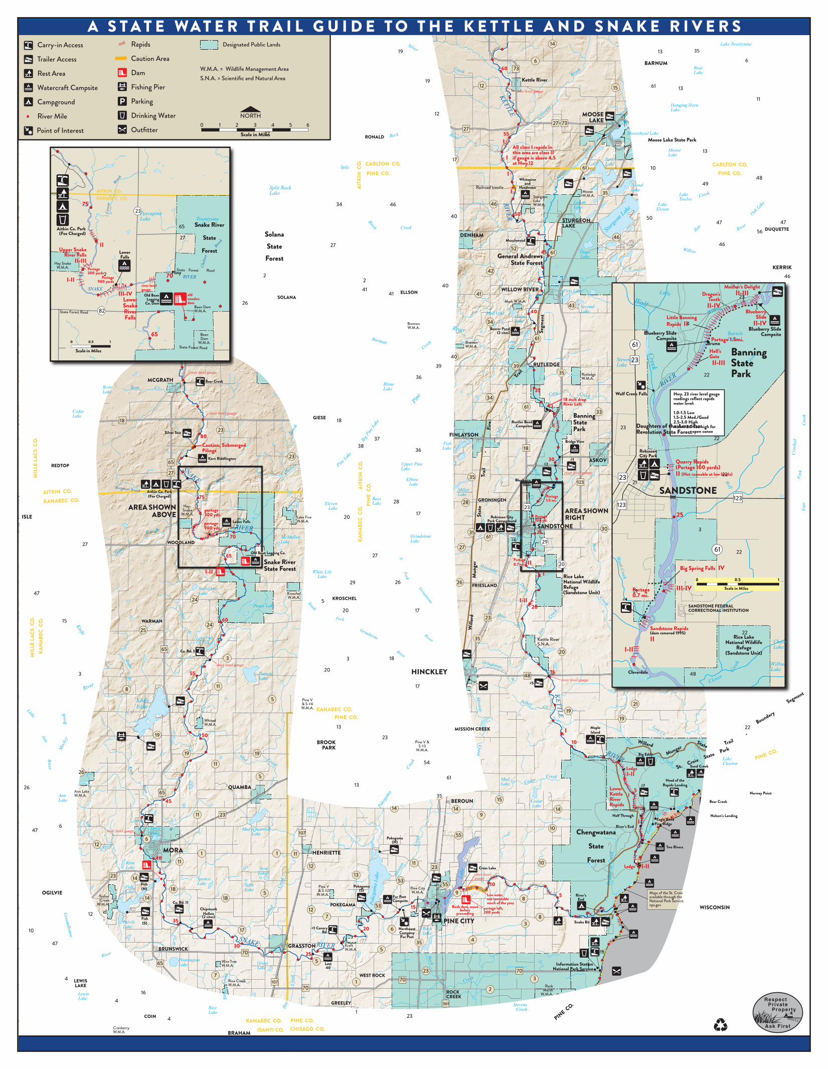
KETTLE 47 15 26 56 48 11 47 SNAKE RIVER SNAKE RIVER KETTLE RIVER Pine Lake Big Pine Lake Split Rock River Silver Creek N Fork Grindstone River South Fork Grindstone River Birch Burman Creek Pine River Knife River Bean Br. Snowshoe Br. Hay Creek Chelsey Brook Horn River Sturgeon Lake Oak Lake Willow River Hay Creek Little Willow Creek Gillespie Brook KETTLE RIVER Cane Creek O’Mix Cr. Bear Creek Creek Deer Cr. Fox Creek Friesland Ditch Skunk Cr. Wolf Cr. Grindstone R. Clover Creek Fork Crooked Wolf Lost Cr. Bear Creek Kettle River Slough Cedar Creek Mission Creek Redhorse Creek Pelkey Cr. Cross Lake Rock Creek Pokegama Lake Pokegama Creek Mission Creek Mud Creek Hay Creek Rice Creek Mud Creek Ann River Groundhouse River Little Ann River Mackey Brook PINE CO. KANABEC CO. AITKIN CO. PINE CO. Moose Willard State Trail - Fire Trail Segment St. Croix State Park Willard Munger State Trail Boundary Segment - State Forest Road State Forest Road State Forest Road RIVER KANABEC CO. AITKIN CO. Wolf Creek Skunk Creek RIVER ] [ Cowen Brook Brook Chelsea Bergman Brook Brook Cowen Knife River A STATE WATER TRAIL GUIDE TO THE KETTLE AND SNAKE RIVERS Carry-in Access Rapids 14 Lake Twentynine 13 35 Designated Public Lands 19 Trailer Access Caution Area 6 6 BARNUM W.M.A. = Wildlife Management Area S.N.A. = Scientific and Natural Area 60 73 Bear Lake Dam Rest Area Kettle River 19 12 Fishing Pier 61 Watercraft Campsite 15 13 river level gauge Parking Campground Hanging Horn Lake 12 MOOSE River Mile Drinking Water Point of Interest Outfitter NORTH LAKE 27 73 0 1 2 3 4 5 6 27 RONALD Moosehead Lake 27 Scale in Miles 55 Moose Lake State Park I All class I rapids in this area are class II Moose 13 Lake I if gauge is above 4.5 Sand 17 CARLTON CO. at Hwy.12 Lake AITKIN CO. CARLTON CO. 61 10 PINE CO. PINE CO. I Whitepine 49 and Island Railroad trestle Headwater Split Rock Lake Lake I Moose 35 Lake W.M.A. Sturgeon Lake Twelve Logan Lake 75 46 34 46 50 Lake W.M.A. Eleven 23 Porcupine Lake 40 50 65 Twentyone Lake Snake River STURGEON DUQUETTE 47 LAKE Creek Aitkin Co. Park (Fee Charged) Solana State DENHAM 46 27 Musclewood 46 II Forest 27 State 52 Upper Snake River Falls 45 Dago General Andrews Lake Lower 61 Forest Falls II-III State Forest Hay Snake W.M.A. KERRIK Portage 300 yards 42 Pliny 2 Portage 70 2 I-II 2 900 yards river level 40 Mother’s Delight II-III SNAKE 41 WILLOW RIVER gauge First Lake 41 ELLSON III-IV 41 Dragon’s Tooth Old Bean old 23 SOLANA wooden Lower Logging Co. Dam Mark W.M.A. 26 dam II-IV Snake 43 Second Bean Dam 82 River W.M.A. 40 Blueberry Slide Lake Mud Lake Clear Falls Little Banning Rapids II Lake 34 II-IV 4 Bremen W.M.A. Blueberry Slide Campsite Beaver Pond (2 sites) Blueberry Slide Campsite Bartels Lake Portage 1.5mi. Bruno 65 Bean 61 Dam Long Lake 0 0.5 1 Bremen W.M.A. W.M.A. 61 Banning State Scale in Miles Hell’s Gate II-III 40 Stevens 23 RUTLEDGE Lake 39 39 Park river level gauge 35 22 Rutledge W.M.A. 36 MCGRATH Bear Creek Rhine Bear Bear Cr. Lake 35 Lake Wolf Creek Falls Hwy. 23 river level gauge readings reflect rapids 34 18 inch drop River Left water level: 61 I 1.0-1.5 Low Cedar 33 river level gauge Banning State Lake 1.5-2.5 Med./Good 2.5-3.0 High GIESE 18 18 FINLAYSON Rustler Bend Campsites I Daughters of the American Above 3.0 Too high for Revolution State Forest open canoe 23 Park 23 Silver Star 80 22 37 MILLE LACS CO. Bridge View Fish Caution, Submerged Pilings 38 Lake 18 36 Robinson City Park 23 Kern Riddlington 30 #1 ASKOV Quarry Rapids (Portage 100 yards) 65 KANABEC CO. AITKIN CO. PINE CO. Upper Pine Lake 35 Elbow #2 REDTOP 27 river level gauge II (Not runnable at low levels) 22 23 Blueberry Slide 123 21 Lake 75 SANDSTONE Miller Aitkin Co. Park Lake (Fee Charged) Portage 1.5 mi. 123 Bass GRONINGEN 28 28 Lake Eleven 123 Hay- AREA SHOWN Snake 23 Lake AREA SHOWN portage 300 yds. ABOVE 17 25 W.M.A. ISLE Portage RIGHT 100 yd. 20 Robinson City Park Campground Lake Five W.M.A. Lower Falls portage 900 yds. SANDSTONE 30 3 25 35 Grindstone #4 70 61 McMullen Lake 29 WOODLAND Lake 27 27 61 22 Old Bean Logging Co. 27 65 Portage 0.7 mi. Snake River II 20 Munger Big Spring Falls IV 0 0.5 1 State Forest White Lily Lake I-II I Rice Lake National Wildlife 26 26 29 FRIESLAND Refuge III-IV Scale in Miles Portage (Sandstone Unit) 21 0.7 mi. Snowshoe Lake Kroschel W.M.A. KROSCHEL 24 #4 I-II 5 Peace Lake SANDSTONE FEDERAL 20 20 17 CORRECTIONAL INSTITUTION 23 MILLE LACS CO. 60 KANABEC CO. WARMAN 24 Sandstone Rapids (dam removed 1995) 25 22 Rice Lake Lake Full 35 Kettle River II National Wildlife Chain Of Fish S.N.A. Refuge Lakes I-II (Sandstone Unit) 65 Co. Rd. 3 20 3 3 18 Wilbur Lake river level gauge 20 HINCKLEY 15 Cloverdale 55 Pomroy Lake 3 48 48 river level gauge #5 11 17 8 Knife 5 Pine V 19 21 & S #4 Lake W.M.A. KANABEC CO. PINE CO. 19 Whited W.M.A. 13 22 Maple MISSION CREEK I Island 19 50 23 Pine V & 10 BROOK S #3 PARK W.M.A. Lake Clayton Sand Creek 19 19 Big Eddy 54 11 Ledge I-II 26 5 61 Mud Head of the Lake 13 #7 Rapids Landing QUAMBA Lower 5 14 Ann Lake 65 Norway Point Kettle I Ann W.M.A. 35 River 15 Cedar Lake 45 BEROUN Bear Creek Rapids Lake 14 14 Eagle Bend 11 23 9 Half Through Nelson’s Landing I Pine Ridge River’s End 10 Mora Mud (Quamba) Lake Chengwatana river level gauge 107 Lake 55 Pokegama 6 (N) 12 State Two Rivers MORA HENRIETTE 1 1 11 40 Forest Ledge I-II 11 10 11 Kent 12 23 Lake 23 14 Spence Cross Lake river level gauge Twin Lakes 53 13 53 10 55 Fish Lake Sells Pokegama (S) & S #2 Pine V Fish Pine City W.M.A. 15 (N) 18 Lake Lake OGILVIE 9 5 Maps of the St. Croix available through the W.M.A. Low water 5 River’s Tosher Fur Post Campsite 14 18 not canoeable 8 End Creek National Park Service. Co. Rd. 11 much of the year. portage left, 200 yards W.M.A. POKEGAMA nps.gov Rock dam, scout before WISCONSIN Chipmunk Hollow 12 proceeding 12 7 8 3 Snake Bit (2 sites) Fish PINE CITY 35 Devils Lake (S) #1 Canary 20 6 Northwest Rock 17 Rd. Company Lake Fur Post 4 35 30 GRASSTON Kraft BRUNSWICK W.M.A. 5 #6 70 25 Information Station Pennington Wire Tree 5 Grass Lost 65 Lake W.M.A. Lake 40 National Park Service 23 70 Rice Creek W.M.A. 7 WEST ROCK 3 70 LEWIS 1 107 LAKE Rock 70 2 Marsh ROCK 16 Lewis Lake 4 W.M.A. CREEK GREELEY 361 Stevens Rice Creek 1 Lake 23 COIN 4 KANABEC CO. PINE CO. Cranberry ISANTI CO. CHISAGO CO. W.M.A. BRAHAM East Creek 47 6 10 47 4 46
Transcript of Kettle River
KET
TLE
47
15
26
56
48
11
47
SNAKE
RIVER
SNAKE RIVER
KETTLE
RIVER
Pine Lak
e
Big P
ine La
ke
Split
Rock River
Silver
Creek
N Fork
Grindstone
River
South
Fork
Grindstone
River
Birch
Burman Cree
k
Pine
River
Knife
River
Bean Br.
Snowshoe Br.
Hay
Creek
Chelsey
Broo
k
Horn
River
Sturge
on Lak
e Oak
Lake
Willow
River
Hay
Creek
Little
Willow
Cree
k
Gillespi
e
Brook
KETTLE RIVER
Cane Creek
O’M
ix
Cr.
Bear Creek
Creek
Deer Cr.
Fox
Creek
Friesland
Ditch
Skunk
Cr. Wolf
Cr.
Grindstone
R. Clover
Cree
k
Fork
C
rook
ed
Wolf
Lost Cr. Bear
Creek
Kettl
e
River Slough
Cedar Creek
Mission
Creek
Redh
orse
Cre
ek
Pelkey Cr.
Cros
s
Lake
Rock
Creek
Poke
gam
a La
ke
Poke
gama
Creek
Miss
ion
Cree
k
Mud
Cr
eek
Hay
C
reek
Rice
Cr
eek
Mud Creek
Ann
River
Groundhouse
River
Little
Ann River
Mac
key
Broo
k
PINE C
O.
KANABEC CO. AITKIN CO.
PINE CO.
Moose
Will
ard
Stat
e Tr
ail
-Fi
re
Trail
Segm
ent
St. Croix State Park
Willard Munger
State Trail
Boundary
Segment
-
State Forest Road
State Forest Road
State Forest Road RIVER
KANABEC CO. AITKIN CO.
Wolf
Creek
Skunk Creek
RIVER
] [
Cowe
n Broo
k
Brook
Chel
sea
Bergman Brook
Brook
Cowe
n
Knife
River
A S T A T E WA T E R T R A I L G U I D E T O T H E K E T T L E A N D S N A K E R I V E R S Carry-in Access Rapids 14 Lake Twentynine
13 35 Designated Public Lands
19Trailer Access Caution Area 66 BARNUM
W.M.A. = Wildlife Management Area S.N.A. = Scientific and Natural Area
60 73 Bear Lake Dam Rest Area
Kettle River 19 12Fishing Pier 61Watercraft Campsite 15 13river level gauge
Parking Campground Hanging HornLake
12 MOOSERiver Mile Drinking Water
Point of Interest Outfitter
NORTHLAKE 27 730 1 2 3 4 5 6
27 RONALD
Moosehead Lake 27Scale in Miles 55 Moose Lake State Park I
All class I rapids inthis area are class II Moose 13
Lake I if gauge is above 4.5 Sand17CARLTON CO. at Hwy.12 Lake
AITK
IN C
O.
CARLTON CO. 61 10 PINE CO. PINE CO. I
Whitepine49and IslandRailroad trestle Headwater Split Rock
Lake Lake I Moose 35 Lake W.M.A. Sturgeon
Lake Twelve LoganLake 75 4634 46
50
Lake W.M.A. Eleven23Porcupine
Lake 40 50 65
TwentyoneLake Snake River
STURGEON DUQUETTE
47LAKE Creek Aitkin Co. Park (Fee Charged) Solana State DENHAM 4627 Musclewood
46II Forest
27State 52Upper SnakeRiver Falls 45 Dago
General Andrews Lake Lower 61
Forest Falls II-III State Forest Hay SnakeW.M.A. KERRIK Portage
300 yards 42Pliny 2Portage 70 2I-II 2900 yards
river level 40 Mother’s DelightII-III
SNAKE 41 WILLOW RIVER gauge First Lake 41 ELLSONIII-IV 41 Dragon’sTooth
Old Bean old 23SOLANA wooden Lower LoggingCo. Dam Mark W.M.A. 26dam II-IV Snake 43 SecondBean Dam
82 River W.M.A. 40 Blueberry Slide
Lake Mud Lake ClearFalls Little Banning
Rapids IILake 34 II-IV 4Bremen W.M.A. Blueberry Slide
Campsite Beaver Pond
(2 sites) Blueberry SlideCampsite
Bartels Lake Portage 1.5mi.
Bruno 65 Bean
61Dam LongLake
0 0.5 1 Bremen W.M.A.
W.M.A. 61 BanningState
Scale in Miles Hell’s Gate II-III
40 Stevens23RUTLEDGE Lake 39 39
Park river level gauge 35 22RutledgeW.M.A. 36MCGRATH Bear Creek RhineBear Bear Cr. Lake 35Lake Wolf Creek Falls Hwy. 23 river level gauge
readings reflect rapids34 18 inch dropRiver Left water level:
61 I 1.0-1.5 Low Cedar 33river level gauge Banning
State Lake 1.5-2.5 Med./Good
2.5-3.0 HighGIESE 1818
FINLAYSON
Rustler Bend Campsites I Daughters of the AmericanAbove 3.0 Too high for
Revolution State Forest open canoe 23Park 23Silver Star
80 2237
MIL
LE L
ACS
CO
.
Bridge View Fish Caution, SubmergedPilings
38 Lake 1836 Robinson City Park 23Kern Riddlington 30 #1 ASKOV Quarry Rapids
(Portage 100 yards)65
KAN
ABEC
CO
.AI
TKIN
CO
. PI
NE
CO
.
Upper PineLake
35Elbow
#2REDTOP 27 river level gauge II (Not runnable at low levels) 2223Blueberry
Slide 123 21Lake
75 SANDSTONE MillerAitkin Co. Park Lake (Fee Charged) Portage
1.5 mi. 123Bass GRONINGEN28 28Lake Eleven 123Hay-AREA SHOWN Snake 23Lake AREA SHOWN portage300 yds. ABOVE 17 25W.M.A. ISLE Portage RIGHT100 yd.
20 Robinson CityPark Campground
Lake Five W.M.A. Lower Falls portage
900 yds. SANDSTONE 30 32535Grindstone
#470 61McMullen
Lake 29WOODLAND Lake 27 27 61 22Old Bean Logging Co. 2765 Portage0.7 mi. Snake River II 20
Mun
ger
Big Spring Falls IV 0 0.5 1
State Forest White LilyLake
I-II I Rice Lake National Wildlife 26 2629 FRIESLAND Refuge III-IV Scale in Miles Portage (Sandstone Unit) 21
0.7 mi. Snowshoe Lake Kroschel
W.M.A. KROSCHEL24 #4I-II 5 Peace Lake SANDSTONE FEDERAL 2020 17 CORRECTIONAL INSTITUTION
23
MIL
LE L
ACS
CO
. 60
KAN
ABEC
CO
. WARMAN 24 Sandstone Rapids
(dam removed 1995)25 22 Rice Lake Lake Full 35 Kettle River II National Wildlife ChainOf Fish S.N.A.
Refuge Lakes I-II (Sandstone Unit) 65 Co. Rd. 3 20 3 3 18
Wilbur Lake
river level gauge 20 HINCKLEY 15 Cloverdale 55 Pomroy
Lake 3 4848
river level gauge #511 178
Knife 5 Pine V
19 21& S #4Lake W.M.A. KANABEC CO.
PINE CO. 19Whited W.M.A. 13 22MapleMISSION CREEK I Island 19 50 23
Pine V & 10BROOK S #3 PARK W.M.A.
Lake ClaytonSand Creek
19 19 Big Eddy
5411 LedgeI-II 26
5 61 Mud Head of the Lake 13 #7 Rapids Landing QUAMBA Lower 5
14
Ann Lake 65 Norway Point Kettle IAnn W.M.A. 35 River 15 CedarLake 45 BEROUN Bear Creek Rapids Lake 14 14
Eagle Bend11 23 9 Half Through Nelson’s Landing
I Pine Ridge River’s End 10Mora Mud (Quamba)Lake Chengwatana river level gauge 107 Lake 55Pokegama6 (N)12 State Two Rivers MORA HENRIETTE 1 1 11
40 Forest Ledge I-II
11 1011Kent 12 23Lake
23 14 Spence
Cross Lake river level gauge
Twin Lakes
53
13 53 1055Fish Lake Sells Pokegama
(S)& S #2 Pine V Fish Pine City
W.M.A.
15
(N) 18 Lake Lake OGILVIE 95 Maps of the St. Croix available through the W.M.A. Low water 5 River’s Tosher Fur Post
Campsite 14 18 not canoeable 8 End Creek National Park Service. Co. Rd. 11 much of the year. portage left,200 yards
W.M.A. POKEGAMA nps.gov Rock dam, scout before WISCONSIN Chipmunk
Hollow 12
proceeding 12 7 8 3 Snake Bit
(2 sites) Fish PINE CITY 35Devils Lake
(S) #1 Canary 20 6 Northwest Rock 17 Rd. Company Lake
Fur Post 43530 GRASSTON Kraft BRUNSWICK W.M.A. 5 #670 25
Information Station Pennington Wire Tree 5Grass Lost65 Lake W.M.A. Lake 40 National Park Service 23 70
Rice Creek W.M.A.
7 WEST ROCK 370LEWIS 1107 LAKE Rock 70 2 Marsh ROCK 16Lewis
Lake 4 W.M.A. CREEK
GREELEY 361 StevensRice Creek 1Lake 23COIN 4 KANABEC CO. PINE CO.
Cranberry ISANTI CO. CHISAGO CO. W.M.A. BRAHAM
East
C
reek
47 6
10
47
4
46

St. L
ouis
Ke
ttle
and
Snak
e Riv
ers
STAT
E W
ATER
TRA
IL M
AP
61
16916
9
61
8
2 53
52
10
35
35
61
169
94
23
23
Dul
uth
Moo
se L
ake
Sand
ston
e
Anok
a
Pine
City
Aitk
in
W I S C O N S I N
Mill
eLa
csLa
ke
Snake Rive
r
RiverKettle
Lake
Supe
rior
Rum
Rive
r
Rive
r
Miss
issip
pi
RiverSt. Croix
River
River
Miss
issipp
i
“The
Min
neso
ta D
epar
tmen
t of N
atur
al Re
sour
ces
is an
Equ
al O
ppor
tuni
ty E
mpl
oyer
”
This
info
rmat
ion is
avail
able
in al
tern
ative
fo
rmat
upo
n re
ques
t.
Min
neso
ta S
tate
Par
ks an
d Tr
ails
Regi
onal
Unit
16
01 M
inne
sota
Driv
eBr
ainer
d, M
N 5
6401
218-
828-
2693
Onl
ine w
ater
trail
info
rmat
ion an
d m
aps c
an b
e fou
nd at
mnd
nr.go
v/wa
tertr
ails
DN
R In
form
atio
n C
ente
rTh
e DN
R’s I
nfor
mat
ion C
ente
r is a
vaila
ble t
o pro
vide f
ree
publ
icatio
ns of
facil
ities
and
serv
ices a
s well
as an
swer
s que
stion
s pe
rtain
ing t
o DN
R re
crea
tiona
l opp
ortu
nitie
s in
Min
neso
ta.
The Kettle River
DIFFICULTY: Most of the river is Class I during low water with some stretches reaching II or III in high water. The Banning Rapids area range in difficulty from Class II-IV at all water levels. WIDTH: 30-250 feet. SCENERY: Most of the river is bounded by aheavy forest of black spruce, fir, birch, aspen, maple, ash, elm and scattered red, white and jack pine. Bluffs occasionally rise more than 100 feet above the river. Rocky cliffs are common along the Banning and Lower Kettle River rapids. The river passes a few towns, houses or farmland, althoughseveral bridges cross the upper reaches. The Kettle in Pine County is a state wild and scenic river. WILDLIFE: Beavers, otters and muskrats are occasionally sighted. White-tailed deer are common. Other mammals include black bears, bobcats, coyotes, mink, raccoons and gray and red fox. Two upland game birds, ruffed grouse and some Canada geese nest near the river.FISH: Smallmouth bass, walleyes and northern pike are caught throughout the river. The Kettle also holds channel catfish, sturgeon and redhorse.GEOLOGY: The gently rolling to steeply undulating land of the Kettle River watershed is formed largely by glacial deposits. The oldest known rocks in the watershed are middle Precambrian folded sedimentary layers underlying the upper Kettle. A wide band of sandstone underlies the river from Willow River to the State Highway 48 bridge, where the Douglas fault crosses the Kettle. Basalt underlies the lower river. HISTORY: The Kettle was the focus of considerable industry near the turn of the century. The forests, once thick with pine, were logged. Land near the river was mined for sandstone and copper. The river itself was dammed to generate electricity and to float sawlogs to nearby mills. Many people near Sandstone took refuge in the Kettle River when the Hinckley fire swept through Pine County September 1, 1894.
The Snake River SCENERY: The upper Snake’s banks are heavily forested with birch, aspen, oak, maple, ash, elm and some black spruce, tamarack and white pine.This stretch is dotted with granite outcrops, near
the falls. From Mora to Pine City, the river travels through wooded banks that give way to a wide farming valley below Grasston.Below Cross Lake, forested banks as well as sandstone bluffs make this stretch very scenic.WILDLIFE: White-tailed deer, black bears, gray and red fox, beavers and muskrats as well as an occasional otter. Bobcats, coyotes, minks, and raccoons are also found in this region. Ruffed grouse, numerous waterfowl and songbirds may be sighted as well.FISH: Walleye, northern pike, smallmouth bass, and catfish. Some of the lakes along the route support panfish populations as well. Lake (Rock) sturgeon are also present-one of few rivers in Minnesota with lake sturgeon.GEOLOGY: Gently rolling hills as well as sharp granite outcrops are all evidences of glacial activity that predominates over the area. Sandstone bluffs are exposed below the Cross Lake stretch.HISTORY: The river gets its name from the Ojibway word Kanabec, or snake, naming it after their enemies, the Dakota, who lived upriver, and who they later displaced.As white men settled in the area, the fur trade was
important along the Snake. Historical information can be found at the Northwest Company Fur Post site—Pine City. Later, logging became an important industry, with evidence such as the Old Bean logging dam and campsite.
Water Levels These two rivers are
susceptible to extreme water level fluctuations. High rain fall or rapid snowmelt will bringwater levels up quickly. Periods of low precipitation will bring water levels down quickly.
High water levels on either river can make rapids more difficult and hazardous. Conditions on the rivers can change quickly, please call the DNR for water level information, or visit our website at: mndnr.gov.
The stretch of the Kettle river that is most runnable for canoeists during low water levels isbetween County Road 52, near Willow River, to Highway 23 near Sandstone.
The stretch of the Snake river that is most runnable for canoeists during low water periods isbetween the Twin Bridges Access near Mora to Pine City
Planning a Safe River TripA successful river trip is safe. To enjoy a safe journey, you should be prepared by getting acquainted with your route. Choose a distance that is comfortable for you.
Water levels can speed or slow you: get information about water levels from the regional DNR Parks and Trails office, or check the DNR website, or the DNR Information Center.
Protect the water and shorelands and leave nothing behind you except footprints. Remember that much of the shorelands are privately owned. Here’s a checklist you should consider in planning yourtrip:
Trip Planning
• Travel with a companion or group. Plan your trip with a map before you depart and advise someone of your plans including planneddeparture and arrival times.
• Most people paddle two to three river miles per hour.
• Bring a first aid kit that includes waterproof matches.
• Beware of river obstructions, such as overhanging and dead trees in the river.
• You must pack out all trash. • Leave only footprints; take only photographs! Rest Areas and Camping Sites • Public rest areas are available along the route
to rest, picnic and explore. • Camp only in designated campsites, which are
available on a first-come, first-served basis. • Bring drinking water. It is only available at a
limited number of rest areas. Drinking river water is not recommended, but if you do it must be treated.
• Respect private property. Stop only at designated sites; much of the shoreland is private property.
• Be sanitary! Use designated toilet facilities or bury human waste away from the river.
Boating Information • Wear a U. S. Coast Guard approved personal
flotation device that state law requires be on board the craft.
• Bring an extra paddle. • Not all portions of this water trail are suitable
for motor use. • Register your watercraft. All watercraft more
than 9 feet in length, including nonmotorizedcanoes and kayaks, must be registered in Minnesota or your state of residence.
Rating White Water Rivers and rapids are rated according to the International Scale of River Difficulty. Ratings are estimates based on observations at low or moderate water levels or on secondhand reports.
CLASS I. Easy rapids with small waves and few obstructions. CLASS II. Rapids with waves up to three feet high. Some maneuvering is required. CLASS III. Difficult rapids with high, irregular waves capable of swamping an open canoe. Narrow chutes may require extensive maneuvering. Usually considered the limit for an experienced paddler in an open canoe.CLASS IV. Long, turbulent rapids with high, irregular waves, constricted passages and blind drops. Decked canoes and kayaks only; open canoes should be portaged.CLASS V. Long, violent rapids with complex routes and steep drops or waterfalls. Hazard to life in the event of a mishap. Runnable only by experts in decked boats. CLASS VI. Cannot be attempted without great risk to life.
Route Description for the Kettle River
River Mile 62.0-56.0 Many short boulder-bed rapids. Class I-II.
See text for more information. 61.1 State Highway 73 bridge. 58.8 Co Rd 12 bridge and river level gauge on abutment. 55.8 State Highway 27 bridge. 55.6-55.3 Class I rapids. 54.7-54.3 Class I rapids. 53.6-53.5 Class I rapids. 52.7-52.6 Class I rapids. 51.6 Railroad trestle. 51.4-51.3 Class I rapids. 50.6 County Highway 46 bridge. 50.0 (L) White Pine Campsite. 49.6 (L) Headwater Campsite. 46.6 (L) Moose Horn River enters. 46.2 (R) Musclewood carry-in access at Co Rd 52 bridge. 42.8 County Highway 41 bridge. 41.9 (L) Willow River enters. 40.3 Bridge, gravel road. 39.4 (R) Beaver Pond Campsites (2 sites). Caution: steep
bank. 37.3 County Highway 61 bridge. Willard Munger State
Trail crossing. 36.2 County Highway 33 bridge. 33.7-33.5 Short Class I boulder-bed rapids. Outcrop on right
with “kettles,” potholes cut by swirling water. 33.4 Possible portage in low water. 33.5-33.4 Rustler Bend Campsites (3 sites). 33.0 Short Class I boulder-bed rapids. 32.9 Interstate 35 bridges. 32.5 Short Class I boulder-bed rapids. 30.4 (L) Bridgeview campsite and access. Fire rings, toilet. The
road to this site joins State Hwy. 23, east of the bridge over the Kettle.
29.8 (L) #1 trailer access, State Highway 23 bridge, River level gauge. Rapids downstream are unrunnable when gauge reads less than one foot.
28.4-28.2 Portage left, 1.5 miles. 28.5 (L) Watercraft campsite. 28.4 (R) Banning State Park #2 trailer access. 28.4-28.2 Blueberry Slide, the first of the Banning Rapids.
Class II-IV. Two steep pitches in this long rapids create large souse holes and standing waves.
28.2 (L) Blueberry Slide primitive campsite. Accessible by portage trail.
27.2-27.8 Mother’s Delight. Class II-III. River rushes through steep boulder-bed rapids into the Dalles of the Kettle River, a short, narrow canyon flanked by sandstone cliffs.
27.8 Dragon’s Tooth, named for a large rock on the right side of the channel near the tail of the rapids. Class II-IV. The river, less than 50 feet wide, has severely undercut the canyon walls. The “tooth” forms a powerful souse hole and waves in high water.
27.6-27.3 Little Banning Rapids, a series of boulder-bed rapids. Class I-III.
27.3 Banning ruins. The town of Banning, grew around major sandstone quarries two miles north of Sandstone. More than 20 million tons of rock were shipped out of Banning. By 1905, however, the quarries were abandoned.
26.9-26.8 Hell’s Gate. Long boulder-bed rapids ending in a steep, narrow pitch between high sandstone escarpments as the Kettle leaves the dalles. Class II-III.
26.4 Wolf Creek Falls. Wolf Creek tumbles over a 10-foot ledge before it joins the Kettle. Find the mouth of the creek on the right and follow the stream about 100 yards into the woods.
26.6 A cave is in the sandstone bluffs on the right. Remains of some sandstone quarries can be seen from the cave downstream to Robinson Park in Sandstone.
25.7 Railroad trestle. 25.5 (R) Quarry Rapids, Class II, portage right 100 yards. This
drop may not be runnable at low water since the entire river tumbles onto sharp boulders; at high water, large back rollers develop.
25.4 (R) Robinson City Park, campground, boat ramp, toilets, well, picnic tables and a shelter.
25.1 State Highway 123 bridge. 24.0-23.4 Portage right 0.7 miles. 23.9-23.9 Big Spring Falls, Class IV, the river splits into two
channels around the island. Right channel drops over cascading waterfall; Left channel curves through boulder-ledge rapids with difficult turns, the falls are followed immediately by dangerous severely undercut ledges which will trap trees, boats and swimmers.IT IS STRONGLY RECOMMENDED NOT TO TRY THESE FALLS AND THAT WAVE SURFING NOT BE ATTEMPTED HERE.
23.5-23.4 Sandstone Rapids, Class II. This is the location of the former Sandstone Dam last used for electricity in 1963. The Dam was removed in 1995, and as a result, Big Spring Falls is visible again.
23.4 (R) Carry-in access near electrical complex/tower. 23.0 Three short boulder-bed rapids. Class I-II. 22.0 Class I rapids. 20.2-19.9 Friesland Rapids. Three boulder-bed pitches.
Class I-II. 15.1-15.0 #5 trailer access on right, State Highway 48 bridge, river level gauge. 11.0 Class I rapids. 8.0 (L) Maple Island trailer access and campsite. 7.8-0.0 Lower Kettle River Rapids, a series of long
boulder-bed pitches. Class I-II. Large standing waves form in high water.
7.0 Willard Munger State Trail crossing. 7.0 (L) Big Eddy. Campsite, toilet and drinking water. 3.6 (L) #7 trailer access, Kennedy Brook. 3.1 (R) Half Through Campsite.
2.5 (R) River’s End Campsite. 1.6 (L) Two Rivers Campsite. 0.0 Boulder-studded channels split around several islands.
Slightly more than a mile downstream, where the two channels of the St. Croix join, the river tumbles over steep, low ledge that forms a three-foot backroller in high water.
Sustainable Ecosystems Outdoor recreation is dependent on a healthy and
attractive natural environment. Sustainable outdoor recreation enables people to enjoy the outdoors without negative impacts on the environment.
Natural shoreline buffers improve water quality by filtering out pollutants and sediments. Healthy and diverse native shoreline plant communities are attractive and provide important shoreline habitat for birds and wildlife.
Route Description for the Snake River
River Mile 84.0 River level gauge, MN Highway #65 bridge. 83.8 (L) Bear Creek Landing, carry-in access. 81.0 State Highway 18 bridge, river level gauge. 79.1 (R) Silver Star Road trailer access. Caution: Submerged pilings. 78.3 (L) Kern Riddlington Campsite. 76.6 (R) Aitkin County Park, trailer access, rest area and campground (fee required). 75.2 (R) Bergmann Brook enters. 74.1-73.7 Class II rapids. 73.8 (L) Cowen Brook enters. 73.3-72.6 Upper Snake River Falls, portage left 300 yards
Class II-III. 72.4-71.5 Lower Snake River Falls, portage left, 900 yards
Class III-IV. 71.5-71.2 Class I-II rapids. 71.5 Lower Falls Campsite, walk-in or canoe-in only. 70.8 (R) Ford Twsp. Road/Highway 23 bridge, river level
gauge. 69.1 (L) Chesley Brook enters. 66.6 (L) Old Wooden Dam, Old Bean Logging Co. Dam
campsite.64.2 Rock Dam, Class I-II. Use caution. 56.8 (R) County Road 3 carry-in access. River level gauge
on bridge, center piling, downstream side. 48.8 County Road 19 bridge. 44.9 State Highway 65 bridge. 44.3 (R) Knife River enters. 41.9 County Road 6 bridge. River level gauge on bridge. 41.9 (L) Mora Municipal trailer access, carry-in. 40.5 Railroad bridge. 40.0 State Highway 65 bridge. 38.3 (R) Ann River enters. 34.9 County Road 11 bridge. 34.8 (R) County Road 11 trailer access.
Groundhouse River confulence. 33.9 (L) Chipmunk Hollow watercraft campsite. 29.9 Rice Creek confluence on right, Mud Creek
confluence on left. 28.4 State Highway 70 bridge. 27.1 State Highway 107 bridge. Town of Grasston. 24.7 (R) Lost 40 watercraft campsite. 22.1 (L) #1 Canary Road carry-in access. 17.4 Pokegama Lake carry-in access, north side of
County Road 7 bridge. 17.0 (L) Mission Creek enters. 16.0 (L) Northwest Company Fur Post Campsite. 15.8 (R) Northwest Company Fur Post Historical site, off
of County Road 7. 14.2 Interstate 35 bridge. 13.5 (L) Pine City trailer access in Pine City. 11.9 (L) Cross Lake trailer access, Pine City. 11.8 Rock dam, portage left 200 yards. 11.7 Carry-in access County Road #9, river gauge on
bridge left (north) pier. 11.7-10.9 Class I rapids, low water, not canoeable much of
the year. 11.7-0.8 Scattered Class I rapids. 7.8 (L) Bear Creek confluence. 5.1 (L) Bass Creek confluence. 1.0 (R) River’s End Campground. 0.0 Confluence with St. Croix River, Snake Bit Access
on right—0.1 mile downstream of Snake River outlet on the St. Croix River.
Natural Shorelands
40% evaporation
10% runoff
50% infiltration
Altered Shorelands
30% evaporation
55% runoff 15% infiltration
A STATE WATER TRAIL GUIDE TO THE KETTLE AND SNAKE RIVERS
All Class I Rapidsin this section are Class II if gauge isabove 4.5 at the Hwy 12 bridge.
500
Lafa
yette
Roa
dSt
. Pau
l, MN
551
55-4
040
651-
296-
6157
Met
ro A
rea
1-88
8-64
6-63
67 M
N To
ll-Fr
ee
mnd
nr.go
v
All P
hoto
s: D
NR
© 2
016
Min
neso
ta D
epar
tmen
t of
Nat
ural
Reso
urce
s