
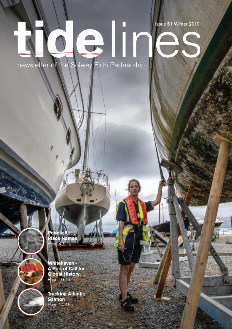
Issue 51 Winter 2019...Issue 51 Winter 2019 People & Place Names Page 4-5 Tracking Atlantic Salmon...
32
Issue 51 Winter 2019 People & Place Names Page 4-5 Tracking Atlantic Salmon Page 14-15 Whitehaven - A Port of Call for Global History Page 10-11
Transcript of Issue 51 Winter 2019...Issue 51 Winter 2019 People & Place Names Page 4-5 Tracking Atlantic Salmon...
Issue 51 Winter 2019
People & Place Names Page 4-5
Tracking Atlantic Salmon Page 14-15
Whitehaven - A Port of Call for Global History Page 10-11
At the meeting of the Board in Dumfries on the 2 September we were joined by the new Carlisle City Council representative, Councilor John Collier, who has
replaced Therese Sidgwick. We extend thanks to Therese for her contributions to SFP and welcome John to the Board. Other members who have stood down from the Board over the summer include Councillors Bill Jefferson and Michael Heaslip, both of whom represented Allerdale Borough Council. We thank Bill and Michael for their individual contributions to the Partnership whilst welcoming Councillor John Cook as a new Board member representing Allerdale.
It is 25 years since the inaugural meeting of SFP took place. SFP was established to support Integrated Coastal Zone Management (ICZM), a concept that was an outcome of the 1992 Rio Earth Summit which sought to promote sustainable development across the globe. Since SFP’s inception demands on the marine environment including coastal waters have increased. Renewable power generation, aquaculture including fish and seaweed farming, seaweed harvesting, environmental designations, marine planning and climate change are just some of the activities or issues that have evolved. Whilst not all of these currently directly affect the Solway, developments associated with power generation have seen subsea cables laid in the Firth and the construction of the Robin Rigg wind farm. In Cumbrian and Dumfries & Galloway waters alternative methods of power generation have been raised though, so far, none of these have come to fruition. Likewise, potential aquaculture proposals have been suggested, most recently seaweed farming, though again, nothing has resulted from these thus far.
Large areas of the Firth have been subject to environmental designations including Luce Bay which became a Marine Protected Area (MPA) in 2016. Luce Bay is also a scallop
fishery and areas within the bay, which offered safe winter fishing, were exempted from designation in order that commercial scalloping could continue. Luce Bay highlighted an example of competing demands on waters of the Solway where traditional inshore commercial fishing, which historically had sole use of much of the Firth, was affected by the designation and could potentially have been completely displaced. The management of Luce Bay provides a good example of a situation where conflicting demands arise but through collaboration between various concerned parties, compromises can be reached to accommodate different interests.
Marine planning has provided a new approach to the management of our seas. Effectively building upon the work that SFP has undertaken since it began, marine planning aims to ensure a sustainable future for coastal and offshore waters through a formal process. Marine planning seeks to manage and balance the various activities, resources and assets of the marine environment and SFP is playing a pivotal role insofar as the process affects the Solway. Approaches to marine planning are being undertaken differently in Scotland and England but the aims are largely the same.
SFP continues to play its role in developments in the Firth either by informing people of activities taking place or by acting as a neutral broker, bringing parties together to reach consensus. There is no reason why, with the support of its members and the wider community, the Partnership cannot continue to be successful over the next 25 years. SFP’s Annual General Meeting will take place on the 29 November 2019 and the event will provide an opportunity to highlight and present an overview of SFP’s achievements as well as work which remains ongoing. Details of the AGM can be found on the SFP website.
Alastair McNeill FCIWEM C.WEM MCMI
Chairman’s Column
2 Solway Firth Partnership
of the fifteenth Annual General Meeting of the Partnership to be held at 2.00pm, Friday 29 Nov 2019, at Tullie House Museum And Art Gallery, Castle St, Carlisle, CA3 8TP This will be followed by short presentations on the work of Solway Firth Partnership. The event is free but booking is essential as numbers are limited. NB: No conference is being held this year. Anyone interested in becoming a Member of Solway Firth Partnership and therefore eligible to vote at the AGM should contact: The Company Secretary or Partnership Manager on 01387 702161 or e-mail [email protected] Scottish Company No: SC250012 Scottish Charity No: SC034376
Notice Is Hereby Given
254-5
Solway Coastwise - A Final Word:
People & Place Names 4 – 5
An Update from the Solway Coast AONB:
Planning for the Future 6 – 7
Focus on Mawbray Banks 8 – 9
Whitehaven - A Port of Call for Global History 10 – 11
The Natural Wonder of Mersehead 12 – 13
Tracking Atlantic Salmon 14 – 15
The Solway Firth Viewed From Powfoot 16 – 17
Fishing Faces 18 – 19
Growth of the Solway salt marshes 20 – 21
An Update from the SMILE Project 22 – 23
Off to a Flying Start for the Hadrian’s Wall Community Archaeology Project 24
Robin Rigg Community Fund Now Open 25
Book Review: Five Arches by D Malcolm Gibson 26
Big Red Bus on Tour 27
Accounts to March 2019 28
Dates for your Diary 29 – 31
Photo Credits: Front Cover: Harbour master Stranraer – Kim Ayers, Pages 4/5: All images – Nic Coombey, SFP; Pages 6/7/8/9: All images – Solway Coast AONB; Pages 10/11: All images – The Beacon, Allerdale Borough Council; Pages 12/13: Background image; Mersehead Coastline – Robert Bennett; Other main images, Mersehead sand flats – Robert Bennett, Mersehead from above – Alan Cairns; Small images clockwise from top left; Waders on shoreline – Lyn Warwick, Tree sparrows and yellowhammer at visitor centre – Calum Murray, RSPB Scotland; Cattle grazing management on Mersehead – RSPB Scotland; Barnacle geese with leucistic bird – Lyn Warwick; Pages 14/15: All images – Environment Agency; 16/17: All images – Richard Spiers except bottom right image – SFP; Pages Pages 18/19: All images – Kim Ayres; Page 20: Saltmarsh at Glencaple – Cai Ladd; Page 21: A view across the saltmarsh to Criffel – Cai Ladd; Nith Estuary & slopes of Criffel – Lucy Miller, University of St Andrews; Researchers on the Nith saltmarshes – William Austin, University of St Andrews; Pages 22/23: All images – Georgina Reid, SFP; Page 24: All images – WallCAP; Page 25: All images – Robin Rigg Offshore Wind; Page 26: All images – D Malcolm Gibson; Page 27: All images – SFP
Contents
18-19
10-11
3Tidelines
4 Solway Firth Partnership
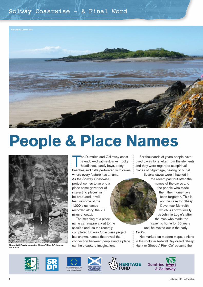
The Dumfries and Galloway coast is endowed with estuaries, rocky headlands, sandy bays, stony
beaches and cliffs perforated with caves where every feature has a name. As the Solway Coastwise project comes to an end a place name gazetteer of interesting places will be produced. It will feature some of the 1,000 plus names recorded along the 200 miles of coast.
The meaning of a place name can inspire a visit to the seaside and, as the recently completed Solway Coastwise project has shown, names that reveal the connection between people and a place can help capture imaginations.
For thousands of years people have used caves for shelter from the elements and they were regarded as spiritual places of pilgrimage, healing or burial.
Several caves were inhabited in the recent past but often the
names of the caves and the people who made them their home have been forgotten. This is not the case for Sheep Cave near Monreith which is known locally
as Johnnie Logie’s after the man who made the
cave his home for 35 years until he moved out in the early
1960s. Not marked on modern maps, a niche
in the rocks in Ardwell Bay called Sheep Hank or Sheeps’ Rink Co’ became the
Solway Coastwise - A Final Word
People & Place Names
The European Agricultural Fundfor Rural Development:
Europe investing in rural areas
Above: Will Purvis; opposite: Sheeps’ Rink Co’, home of Will Purvis
Ardwall or Larry's Isle
5Tidelines
Solway Coastwise - A Final Word
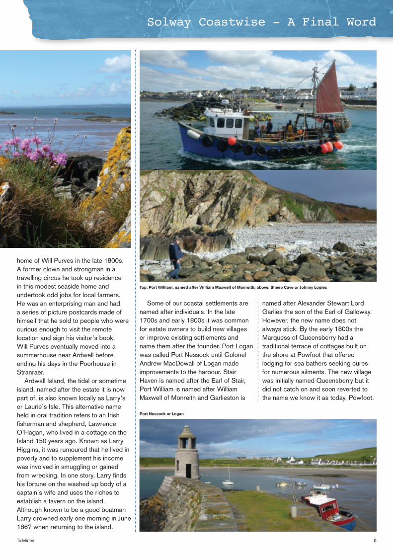
Some of our coastal settlements are named after individuals. In the late 1700s and early 1800s it was common for estate owners to build new villages or improve existing settlements and name them after the founder. Port Logan was called Port Nessock until Colonel Andrew MacDowall of Logan made improvements to the harbour. Stair Haven is named after the Earl of Stair, Port William is named after William Maxwell of Monreith and Garlieston is
named after Alexander Stewart Lord Garlies the son of the Earl of Galloway. However, the new name does not always stick. By the early 1800s the Marquess of Queensberry had a traditional terrace of cottages built on the shore at Powfoot that offered lodging for sea bathers seeking cures for numerous ailments. The new village was initially named Queensberry but it did not catch on and soon reverted to the name we know it as today, Powfoot.
home of Will Purves in the late 1800s. A former clown and strongman in a travelling circus he took up residence in this modest seaside home and undertook odd jobs for local farmers. He was an enterprising man and had a series of picture postcards made of himself that he sold to people who were curious enough to visit the remote location and sign his visitor’s book. Will Purves eventually moved into a summerhouse near Ardwell before ending his days in the Poorhouse in Stranraer.
Ardwall Island, the tidal or sometime island, named after the estate it is now part of, is also known locally as Larry’s or Laurie’s Isle. This alternative name held in oral tradition refers to an Irish fisherman and shepherd, Lawrence O’Hagan, who lived in a cottage on the Island 150 years ago. Known as Larry Higgins, it was rumoured that he lived in poverty and to supplement his income was involved in smuggling or gained from wrecking. In one story, Larry finds his fortune on the washed up body of a captain’s wife and uses the riches to establish a tavern on the island. Although known to be a good boatman Larry drowned early one morning in June 1867 when returning to the island.
Top: Port William, named after William Maxwell of Monreith; above: Sheep Cave or Johnny Logies
Port Nessock or Logan
6 Solway Firth Partnership
An Update from the Solway Coast AONB
Planning for the Future
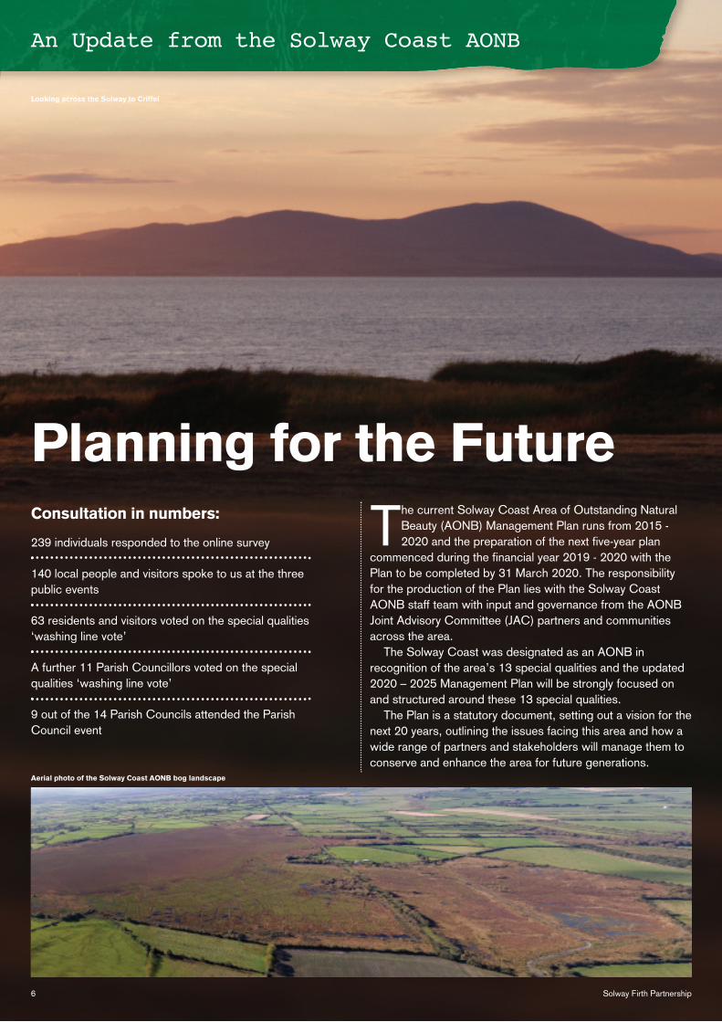
The current Solway Coast Area of Outstanding Natural Beauty (AONB) Management Plan runs from 2015 - 2020 and the preparation of the next five-year plan
commenced during the financial year 2019 - 2020 with the Plan to be completed by 31 March 2020. The responsibility for the production of the Plan lies with the Solway Coast AONB staff team with input and governance from the AONB Joint Advisory Committee (JAC) partners and communities across the area.
The Solway Coast was designated as an AONB in recognition of the area’s 13 special qualities and the updated 2020 – 2025 Management Plan will be strongly focused on and structured around these 13 special qualities.
The Plan is a statutory document, setting out a vision for the next 20 years, outlining the issues facing this area and how a wide range of partners and stakeholders will manage them to conserve and enhance the area for future generations.
Consultation in numbers:
239 individuals responded to the online survey
140 local people and visitors spoke to us at the three public events
63 residents and visitors voted on the special qualities ‘washing line vote’
A further 11 Parish Councillors voted on the special qualities ‘washing line vote’
9 out of the 14 Parish Councils attended the Parish Council event
Looking across the Solway to Criffel
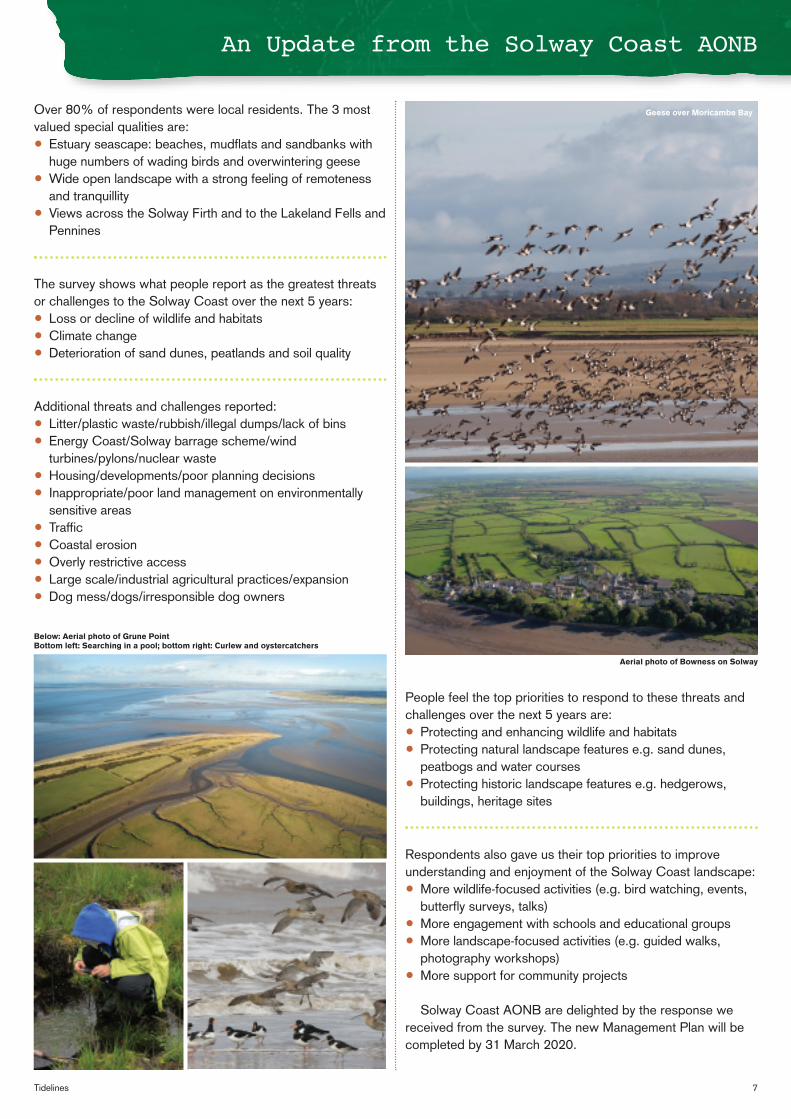
Aerial photo of the Solway Coast AONB bog landscape
7Tidelines
An Update from the Solway Coast AONB
Over 80% of respondents were local residents. The 3 most valued special qualities are: • Estuary seascape: beaches, mudflats and sandbanks with
huge numbers of wading birds and overwintering geese • Wide open landscape with a strong feeling of remoteness
and tranquillity • Views across the Solway Firth and to the Lakeland Fells and
Pennines
The survey shows what people report as the greatest threats or challenges to the Solway Coast over the next 5 years: • Loss or decline of wildlife and habitats • Climate change • Deterioration of sand dunes, peatlands and soil quality
Additional threats and challenges reported: • Litter/plastic waste/rubbish/illegal dumps/lack of bins • Energy Coast/Solway barrage scheme/wind
turbines/pylons/nuclear waste • Housing/developments/poor planning decisions • Inappropriate/poor land management on environmentally
sensitive areas • Traffic • Coastal erosion • Overly restrictive access • Large scale/industrial agricultural practices/expansion • Dog mess/dogs/irresponsible dog owners
People feel the top priorities to respond to these threats and challenges over the next 5 years are: • Protecting and enhancing wildlife and habitats • Protecting natural landscape features e.g. sand dunes,
peatbogs and water courses • Protecting historic landscape features e.g. hedgerows,
buildings, heritage sites
Respondents also gave us their top priorities to improve understanding and enjoyment of the Solway Coast landscape: • More wildlife-focused activities (e.g. bird watching, events,
butterfly surveys, talks) • More engagement with schools and educational groups • More landscape-focused activities (e.g. guided walks,
photography workshops) • More support for community projects
Solway Coast AONB are delighted by the response we
received from the survey. The new Management Plan will be completed by 31 March 2020.
Geese over Moricambe Bay
Aerial photo of Bowness on Solway
Below: Aerial photo of Grune Point Bottom left: Searching in a pool; bottom right: Curlew and oystercatchers
8 Solway Firth Partnership
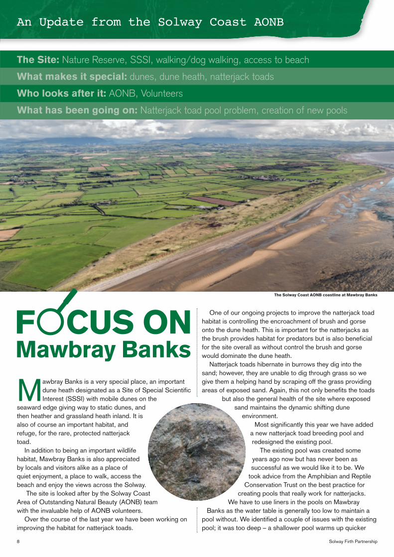
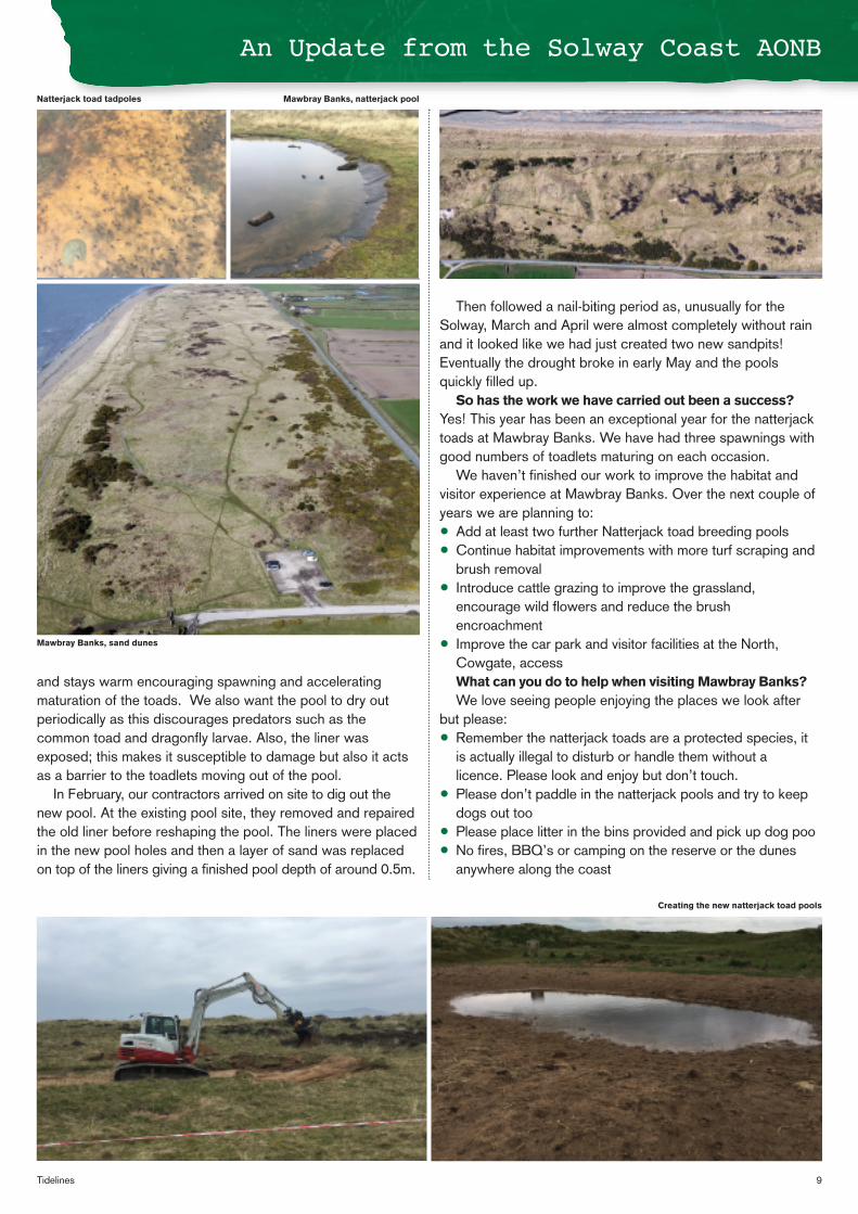
Mawbray Banks is a very special place, an important dune heath designated as a Site of Special Scientific Interest (SSSI) with mobile dunes on the
seaward edge giving way to static dunes, and then heather and grassland heath inland. It is also of course an important habitat, and refuge, for the rare, protected natterjack toad.
In addition to being an important wildlife habitat, Mawbray Banks is also appreciated by locals and visitors alike as a place of quiet enjoyment, a place to walk, access the beach and enjoy the views across the Solway.
The site is looked after by the Solway Coast Area of Outstanding Natural Beauty (AONB) team with the invaluable help of AONB volunteers.
Over the course of the last year we have been working on improving the habitat for natterjack toads.
One of our ongoing projects to improve the natterjack toad habitat is controlling the encroachment of brush and gorse onto the dune heath. This is important for the natterjacks as the brush provides habitat for predators but is also beneficial for the site overall as without control the brush and gorse would dominate the dune heath.
Natterjack toads hibernate in burrows they dig into the sand; however, they are unable to dig through grass so we give them a helping hand by scraping off the grass providing areas of exposed sand. Again, this not only benefits the toads
but also the general health of the site where exposed sand maintains the dynamic shifting dune
environment. Most significantly this year we have added
a new natterjack toad breeding pool and redesigned the existing pool.
The existing pool was created some years ago now but has never been as successful as we would like it to be. We
took advice from the Amphibian and Reptile Conservation Trust on the best practice for
creating pools that really work for natterjacks. We have to use liners in the pools on Mawbray
Banks as the water table is generally too low to maintain a pool without. We identified a couple of issues with the existing pool; it was too deep – a shallower pool warms up quicker
An Update from the Solway Coast AONB
Mawbray Banks
The Site: Nature Reserve, SSSI, walking/dog walking, access to beach
What makes it special: dunes, dune heath, natterjack toads
Who looks after it: AONB, Volunteers
What has been going on: Natterjack toad pool problem, creation of new pools
The Solway Coast AONB coastline at Mawbray Banks
9Tidelines
and stays warm encouraging spawning and accelerating maturation of the toads. We also want the pool to dry out periodically as this discourages predators such as the common toad and dragonfly larvae. Also, the liner was exposed; this makes it susceptible to damage but also it acts as a barrier to the toadlets moving out of the pool.
In February, our contractors arrived on site to dig out the new pool. At the existing pool site, they removed and repaired the old liner before reshaping the pool. The liners were placed in the new pool holes and then a layer of sand was replaced on top of the liners giving a finished pool depth of around 0.5m.
Then followed a nail-biting period as, unusually for the Solway, March and April were almost completely without rain and it looked like we had just created two new sandpits! Eventually the drought broke in early May and the pools quickly filled up.
So has the work we have carried out been a success? Yes! This year has been an exceptional year for the natterjack toads at Mawbray Banks. We have had three spawnings with good numbers of toadlets maturing on each occasion.
We haven’t finished our work to improve the habitat and visitor experience at Mawbray Banks. Over the next couple of years we are planning to: • Add at least two further Natterjack toad breeding pools • Continue habitat improvements with more turf scraping and
brush removal • Introduce cattle grazing to improve the grassland,
encourage wild flowers and reduce the brush encroachment
• Improve the car park and visitor facilities at the North, Cowgate, access What can you do to help when visiting Mawbray Banks? We love seeing people enjoying the places we look after
but please: • Remember the natterjack toads are a protected species, it
is actually illegal to disturb or handle them without a licence. Please look and enjoy but don’t touch.
• Please don’t paddle in the natterjack pools and try to keep dogs out too
• Please place litter in the bins provided and pick up dog poo • No fires, BBQ’s or camping on the reserve or the dunes
anywhere along the coast
An Update from the Solway Coast AONB
Natterjack toad tadpoles Mawbray Banks, natterjack pool
Mawbray Banks, sand dunes
Creating the new natterjack toad pools
10 Solway Firth Partnership
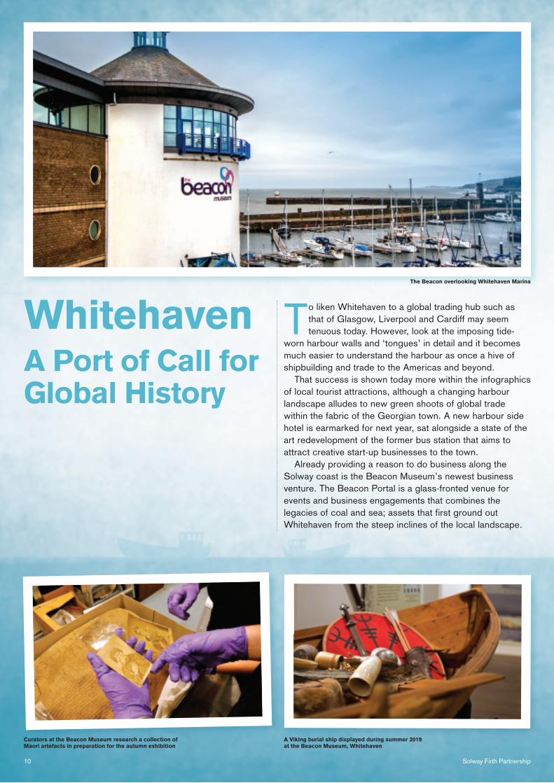
To liken Whitehaven to a global trading hub such as that of Glasgow, Liverpool and Cardiff may seem tenuous today. However, look at the imposing tide-
worn harbour walls and ‘tongues’ in detail and it becomes much easier to understand the harbour as once a hive of shipbuilding and trade to the Americas and beyond.
That success is shown today more within the infographics of local tourist attractions, although a changing harbour landscape alludes to new green shoots of global trade within the fabric of the Georgian town. A new harbour side hotel is earmarked for next year, sat alongside a state of the art redevelopment of the former bus station that aims to attract creative start-up businesses to the town.
Already providing a reason to do business along the Solway coast is the Beacon Museum’s newest business venture. The Beacon Portal is a glass-fronted venue for events and business engagements that combines the legacies of coal and sea; assets that first ground out Whitehaven from the steep inclines of the local landscape.
A Port of Call for Global History
Whitehaven
A Viking burial ship displayed during summer 2019 at the Beacon Museum, Whitehaven
The Beacon overlooking Whitehaven Marina
Curators at the Beacon Museum research a collection of Maori artefacts in preparation for the autumn exhibition
11Tidelines
Set into the former Wellington Pit site, the Portal’s location harks back to the coal dust that still runs in the lifeblood of the area’s inhabitants. The venue, completed at the end of 2017, sits where coal wagons dropped down to barges on the water’s edge. Latterly steam would come to take centre stage during the Victorian era as the harbour tongues would become a final destination for locomotives.
Perched above the West Strand of today, green spaces and footpaths crisscross the edge of a steep embankment, once home to a notorious slab of rudimentary housing perilously perched on an incline that today would be baulked at by planners. The unsanitary neighbourhood quickly became a stronghold for the most impoverished within the mining community, and was ironically named Mountpleasant.
Today’s surrounds offer a marked contrast to what came before, with a picturesque pleasure boating marina flanked by the curved facades of the Museum and neighbouring Portal. A new hull-shaped coastal activity centre has been
mooted for further down the West Strand - a keystone project developed by Whitehaven Harbour Commissioner.
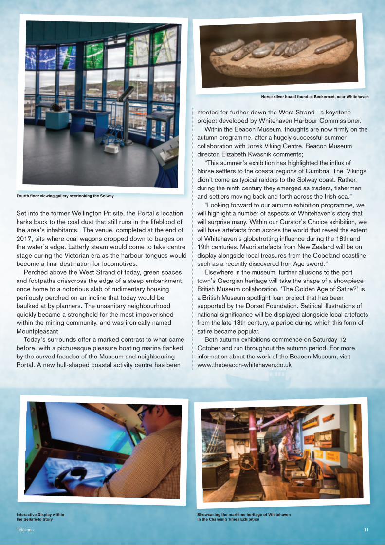
Within the Beacon Museum, thoughts are now firmly on the autumn programme, after a hugely successful summer collaboration with Jorvik Viking Centre. Beacon Museum director, Elizabeth Kwasnik comments;
“This summer’s exhibition has highlighted the influx of Norse settlers to the coastal regions of Cumbria. The ‘Vikings’ didn’t come as typical raiders to the Solway coast. Rather, during the ninth century they emerged as traders, fishermen and settlers moving back and forth across the Irish sea.”
“Looking forward to our autumn exhibition programme, we will highlight a number of aspects of Whitehaven’s story that will surprise many. Within our Curator’s Choice exhibition, we will have artefacts from across the world that reveal the extent of Whitehaven’s globetrotting influence during the 18th and 19th centuries. Maori artefacts from New Zealand will be on display alongside local treasures from the Copeland coastline, such as a recently discovered Iron Age sword.”
Elsewhere in the museum, further allusions to the port town’s Georgian heritage will take the shape of a showpiece British Museum collaboration. ‘The Golden Age of Satire?’ is a British Museum spotlight loan project that has been supported by the Dorset Foundation. Satirical illustrations of national significance will be displayed alongside local artefacts from the late 18th century, a period during which this form of satire became popular.
Both autumn exhibitions commence on Saturday 12 October and run throughout the autumn period. For more information about the work of the Beacon Museum, visit www.thebeacon-whitehaven.co.uk
Fourth floor viewing gallery overlooking the Solway
Showcasing the maritime heritage of Whitehaven in the Changing Times Exhibition
Norse silver hoard found at Beckermet, near Whitehaven
Interactive Display within the Sellafield Story
12 Solway Firth Partnership
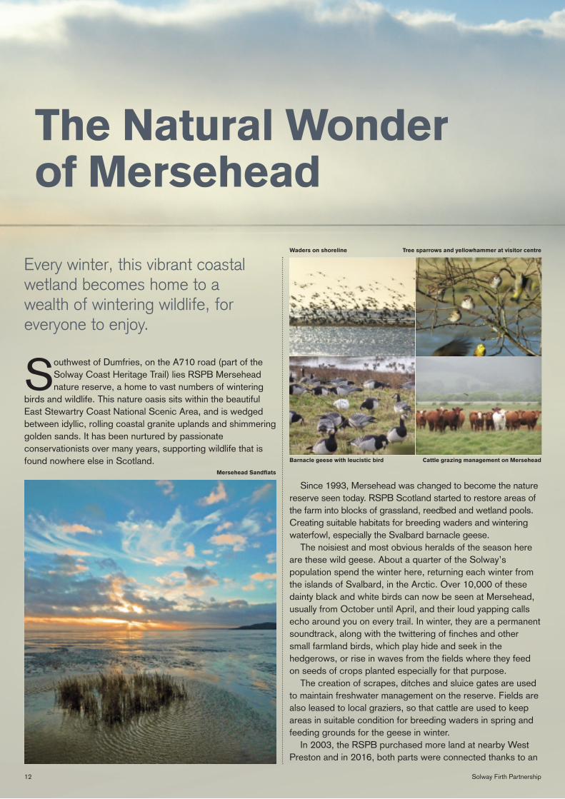
Southwest of Dumfries, on the A710 road (part of the Solway Coast Heritage Trail) lies RSPB Mersehead nature reserve, a home to vast numbers of wintering
birds and wildlife. This nature oasis sits within the beautiful East Stewartry Coast National Scenic Area, and is wedged between idyllic, rolling coastal granite uplands and shimmering golden sands. It has been nurtured by passionate conservationists over many years, supporting wildlife that is found nowhere else in Scotland.
Since 1993, Mersehead was changed to become the nature reserve seen today. RSPB Scotland started to restore areas of the farm into blocks of grassland, reedbed and wetland pools. Creating suitable habitats for breeding waders and wintering waterfowl, especially the Svalbard barnacle geese.
The noisiest and most obvious heralds of the season here are these wild geese. About a quarter of the Solway’s population spend the winter here, returning each winter from the islands of Svalbard, in the Arctic. Over 10,000 of these dainty black and white birds can now be seen at Mersehead, usually from October until April, and their loud yapping calls echo around you on every trail. In winter, they are a permanent soundtrack, along with the twittering of finches and other small farmland birds, which play hide and seek in the hedgerows, or rise in waves from the fields where they feed on seeds of crops planted especially for that purpose.
The creation of scrapes, ditches and sluice gates are used to maintain freshwater management on the reserve. Fields are also leased to local graziers, so that cattle are used to keep areas in suitable condition for breeding waders in spring and feeding grounds for the geese in winter.
In 2003, the RSPB purchased more land at nearby West Preston and in 2016, both parts were connected thanks to an
The Natural Wonder of Mersehead
Every winter, this vibrant coastal wetland becomes home to a wealth of wintering wildlife, for everyone to enjoy.
Waders on shoreline
Barnacle geese with leucistic bird Cattle grazing management on Mersehead
Mersehead Sandflats
Tree sparrows and yellowhammer at visitor centre
13Tidelines
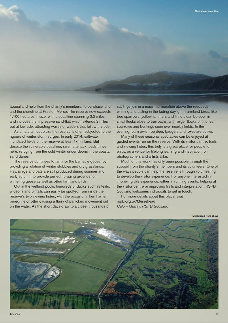
appeal and help from the charity’s members, to purchase land and the shoreline at Preston Merse. The reserve now exceeds 1,100 hectares in size, with a coastline spanning 3.2 miles and includes the impressive sand-flat, which extends 3 miles out at low tide, attracting waves of waders that follow the tide.
As a natural floodplain, the reserve is often subjected to the rigours of winter storm surges. In early 2014, saltwater inundated fields on the reserve at least 1km inland. But despite the vulnerable coastline, rare natterjack toads thrive here, refuging from the cold winter under debris in the coastal sand dunes.
The reserve continues to farm for the barnacle goose, by providing a rotation of winter stubbles and dry grasslands. Hay, silage and oats are still produced during summer and early autumn, to provide perfect foraging grounds for wintering geese as well as other farmland birds.
Out in the wetland pools, hundreds of ducks such as teals, wigeons and pintails can easily be spotted from inside the reserve’s two viewing hides, with the occasional hen harrier, peregrine or otter causing a flurry of panicked movement out on the water. As the short days draw to a close, thousands of
starlings join in a mass murmuration above the reedbeds, whirling and calling in the fading daylight. Farmland birds, like tree sparrows, yellowhammers and linnets can be seen in small flocks close to trail paths, with larger flocks of finches, sparrows and buntings seen over nearby fields. In the evening, barn owls, roe deer, badgers and foxes are active.
Many of these seasonal spectacles can be enjoyed at guided events run on the reserve. With its visitor centre, trails and viewing hides, this truly is a great place for people to enjoy, as a venue for lifelong learning and inspiration for photographers and artists alike.
Much of this work has only been possible through the support from the charity’s members and its volunteers. One of the ways people can help the reserve is through volunteering to develop the visitor experience. For anyone interested in improving this experience, either in running events, helping at the visitor centre or improving trails and interpretation, RSPB Scotland welcomes individuals to get in touch.
For more details about this place, visit rspb.org.uk/Mersehead Calum Murray, RSPB Scotland
Mersehead coastline
Mersehead from above
14 Solway Firth Partnership
At between 120-180mm long, salmon silver up to become “smolts”. They migrate down through the river, navigating hazards such as natural and man-made barriers, predators, and adverse flow conditions. Once in the estuary, they begin the long swim to their marine feeding grounds where they will grow quickly to reach adulthood.
In the face of a changing climate and other influences, it is widely accepted that salmon are finding it increasingly hard to survive and thrive at sea in their marine feeding grounds. Poor marine conditions are believed to be the key reason for the dramatic decline in the numbers of salmon returning to our rivers.
Salmon face numerous threats within freshwater, particularly during the smolt stage. We know that the number of smolts that make it down through the freshwater catchment to sea directly influences the number of returning adult salmon, so any increase in smolt survival on their way to sea will increase numbers of adult salmon returning to our rivers. This is something we can influence once we know where the main issues lie.
(Salmo salar) in the Cumbrian River Derwent
Tracking Atlantic Salmon
Background
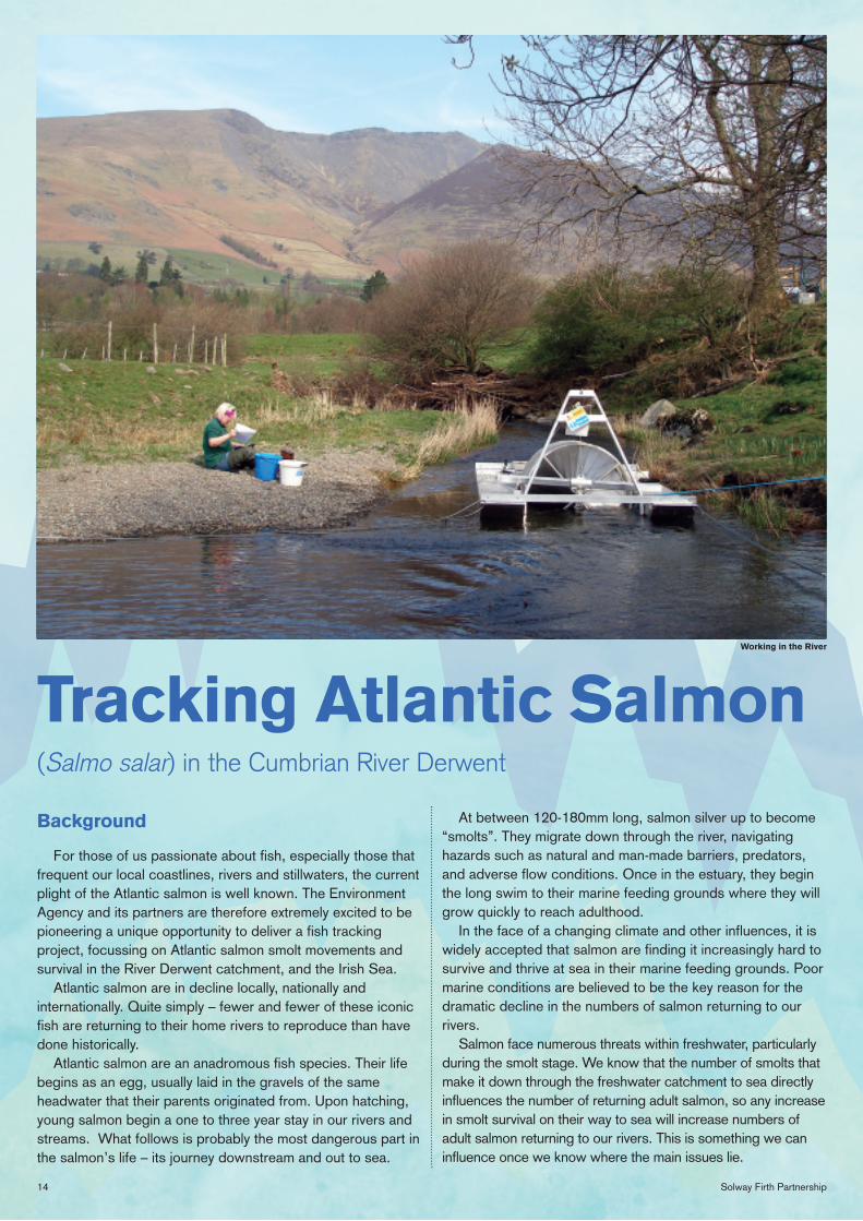
For those of us passionate about fish, especially those that frequent our local coastlines, rivers and stillwaters, the current plight of the Atlantic salmon is well known. The Environment Agency and its partners are therefore extremely excited to be pioneering a unique opportunity to deliver a fish tracking project, focussing on Atlantic salmon smolt movements and survival in the River Derwent catchment, and the Irish Sea.
Atlantic salmon are in decline locally, nationally and internationally. Quite simply – fewer and fewer of these iconic fish are returning to their home rivers to reproduce than have done historically.
Atlantic salmon are an anadromous fish species. Their life begins as an egg, usually laid in the gravels of the same headwater that their parents originated from. Upon hatching, young salmon begin a one to three year stay in our rivers and streams. What follows is probably the most dangerous part in the salmon’s life – its journey downstream and out to sea.
Working in the River
15Tidelines
What are we proposing?
We recognise that we need to better understand the impact of the variety of threats to smolts on their journey down through the Derwent catchment. If we learn more about these threats, we may be able to do something about them and this, in turn, may improve smolt survival and thus improve salmon stocks.
Through partnership with the University of Glasgow, we will be using acoustic tagging and tracking technology to obtain this information. Over the next two years we will be catching smolts as they head down-river, fitting them with acoustic transmitters, and following them using monitoring equipment placed in key parts of the catchment.
Equipment will be deployed at known environmental bottlenecks, and around areas we suspect smolts are likely to be delayed or lost at. These include weirs and their mill streams, large lakes, and the tidal zone where estuaries and the coast present new challenges to these fish. The data collected will tell us more about the movement of fish around, through and / or over structures, their migration speeds between locations, and crucially their survival from reach-to-reach. We will then use this data to inform key management decisions aimed at improving survival of smolts wherever possible, with the long term aim of improving salmon populations.
This crucial and exciting project will be pioneering work in Cumbria and the wider Solway area.
The added bonus
By good fortune, a concurrent EU funded project called “SeaMonitor” is deploying monitoring equipment in the Irish Sea from 2020 to 2022. This project aims to identify the movements of, amongst other things, salmon smolts on their marine journeys. The equipment used will be capable of recording any tagged Derwent smolts as they head out to the high seas, which means we’ll be in the enviable position of being able to track our fish not only through the freshwater phase, but also far beyond our local coastline. What a fantastic opportunity!!
How can we achieve all this?
The reason this study has now become a real, tangible piece of pioneering science is down to the strong partnership we have within the Derwent system, and the passion and drive of individuals, organisations and associations who recognise the importance of salmon to our rivers and the opportunity this work represents. This study, although in its infancy, is already indebted to their support and efforts.
But, we are not quite home and dry… These studies are expensive, and we are unfortunately not fully-funded yet. A PhD recruitment process is ongoing at the time of writing however, and we are hopeful that the strong partnership effort will continue to flourish and enable us to see this project through to fruition.
How can you help?
Do you want to know more? Could you or your organisation help, or contribute? To be successful, this project needs strong ongoing collaboration with partners, and anyone invested in improving things for Derwent salmon and salmon in general. For more information please contact either Dr Andy Gowans or Phil Ramsden at the email addresses below: [email protected] [email protected]
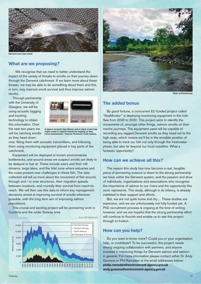
Derwent sea trout smolt
River at Portinscale
Source: ICES WGNAS report
0
2,000
4,000
6,000
8,000
10,000
12,000
1960
1962
1964
1966
1968
1970
1972
1974
1976
1978
1980
1982
1984
1986
1988
1990
1992
1994
1996
1998
2000
2002
2004
2006
2008
2010
2012
2014
2016
Nom
inal
cat
ch (t
)
Northern Europe
Southern Europe
North America
Greenland & Faroes
A typical acoustic tag (above) and a rotary screw trap (right) used to capture smolts for tagging as they move downstream – Source: Professor Colin Adams.
16 Solway Firth Partnership
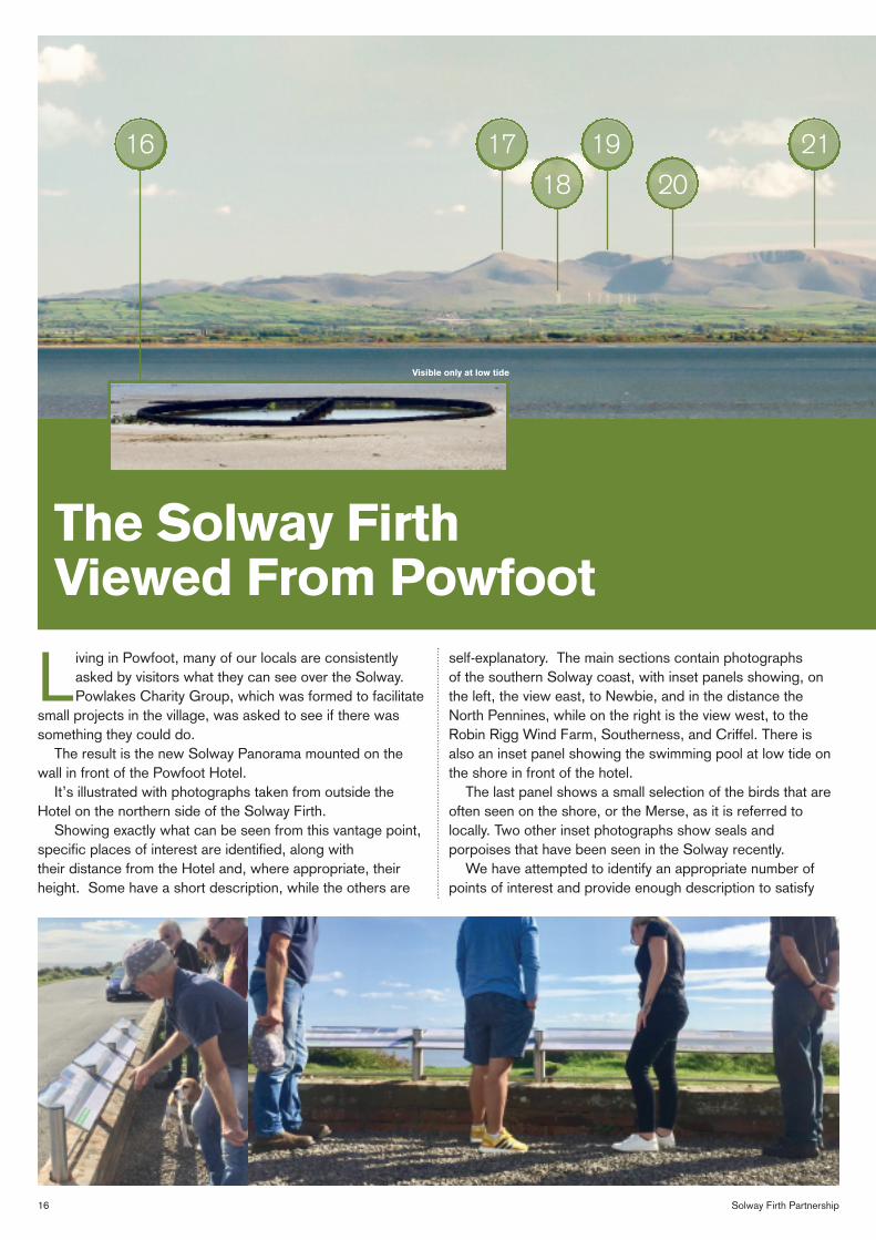
Living in Powfoot, many of our locals are consistently asked by visitors what they can see over the Solway. Powlakes Charity Group, which was formed to facilitate
small projects in the village, was asked to see if there was something they could do.
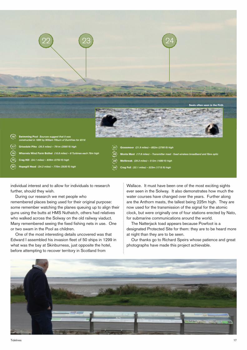
The result is the new Solway Panorama mounted on the wall in front of the Powfoot Hotel.
It’s illustrated with photographs taken from outside the Hotel on the northern side of the Solway Firth.
Showing exactly what can be seen from this vantage point, specific places of interest are identified, along with their distance from the Hotel and, where appropriate, their height. Some have a short description, while the others are
self-explanatory. The main sections contain photographs of the southern Solway coast, with inset panels showing, on the left, the view east, to Newbie, and in the distance the North Pennines, while on the right is the view west, to the Robin Rigg Wind Farm, Southerness, and Criffel. There is also an inset panel showing the swimming pool at low tide on the shore in front of the hotel.
The last panel shows a small selection of the birds that are often seen on the shore, or the Merse, as it is referred to locally. Two other inset photographs show seals and porpoises that have been seen in the Solway recently.
We have attempted to identify an appropriate number of points of interest and provide enough description to satisfy
The Solway Firth Viewed From Powfoot
Visible only at low tide
16 1718 20
19 21
17Tidelines
individual interest and to allow for individuals to research further, should they wish.
During our research we met people who remembered places being used for their original purpose: some remember watching the planes queuing up to align their guns using the butts at HMS Nuthatch, others had relatives who walked across the Solway on the old railway viaduct. Many remembered seeing the fixed fishing nets in use. One or two swam in the Pool as children.
One of the most interesting details uncovered was that Edward I assembled his invasion fleet of 50 ships in 1299 in what was the bay at Skinburness, just opposite the hotel, before attempting to recover territory in Scotland from
Wallace. It must have been one of the most exciting sights ever seen in the Solway. It also demonstrates how much the water courses have changed over the years. Further along are the Anthorn masts, the tallest being 225m high. They are now used for the transmission of the signal for the atomic clock, but were originally one of four stations erected by Nato, for submarine communications around the world.
The Natterjack toad appears because Powfoot is a designated Protected Site for them: they are to be heard more at night than they are to be seen.
Our thanks go to Richard Speirs whose patience and great photographs have made this project achievable.
Seals often seen in the Firth
16 Swimming Pool Sources suggest that it was constructed in 1899 by William Tilburn of Dumfries for £516
17 Grisedale Pike (26.5 miles) – 791m (2595 ft) high 18 Wharrels Wind Farm Bothel (16.8 miles) – 8 Turbines each 76m high 19 Crag Hill (24.1 miles) – 839m (2753 ft) high 20 Hopegill Head (24.2 miles) – 770m (2530 ft) high
21 Grassmoor (21.9 miles) – 852m (2795 ft) high 22 Moota Mast (17.8 miles) – Transmitter mast - fixed wireless broadband and fibre optic 23 Mellbreak (29.3 miles) – 512m (1680 ft) high 24 Crag Fell (32.1 miles) – 523m (1715 ft) high
22 23 24
18 Solway Firth Partnership
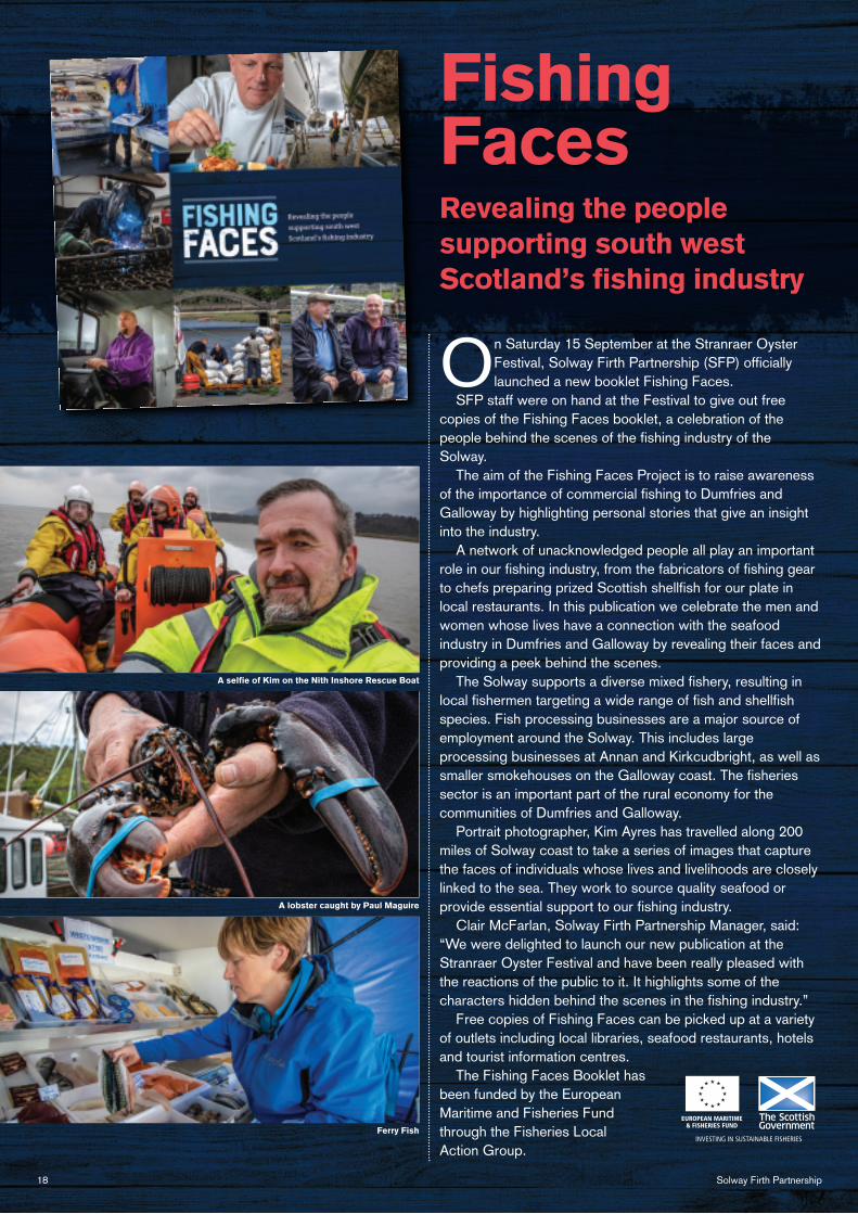
On Saturday 15 September at the Stranraer Oyster Festival, Solway Firth Partnership (SFP) officially launched a new booklet Fishing Faces.
SFP staff were on hand at the Festival to give out free copies of the Fishing Faces booklet, a celebration of the people behind the scenes of the fishing industry of the Solway.
The aim of the Fishing Faces Project is to raise awareness of the importance of commercial fishing to Dumfries and Galloway by highlighting personal stories that give an insight into the industry.
A network of unacknowledged people all play an important role in our fishing industry, from the fabricators of fishing gear to chefs preparing prized Scottish shellfish for our plate in local restaurants. In this publication we celebrate the men and women whose lives have a connection with the seafood industry in Dumfries and Galloway by revealing their faces and providing a peek behind the scenes.
The Solway supports a diverse mixed fishery, resulting in local fishermen targeting a wide range of fish and shellfish species. Fish processing businesses are a major source of employment around the Solway. This includes large processing businesses at Annan and Kirkcudbright, as well as smaller smokehouses on the Galloway coast. The fisheries sector is an important part of the rural economy for the communities of Dumfries and Galloway.
Portrait photographer, Kim Ayres has travelled along 200 miles of Solway coast to take a series of images that capture the faces of individuals whose lives and livelihoods are closely linked to the sea. They work to source quality seafood or provide essential support to our fishing industry.
Clair McFarlan, Solway Firth Partnership Manager, said: “We were delighted to launch our new publication at the Stranraer Oyster Festival and have been really pleased with the reactions of the public to it. It highlights some of the characters hidden behind the scenes in the fishing industry.”
Free copies of Fishing Faces can be picked up at a variety of outlets including local libraries, seafood restaurants, hotels and tourist information centres.
The Fishing Faces Booklet has been funded by the European Maritime and Fisheries Fund through the Fisheries Local Action Group.
Revealing the people supporting south west Scotland’s fishing industry
Fishing Faces
EUROPEAN MARITIME & FISHERIES FUND
INVESTING IN SUSTAINABLE FISHERIES
A selfie of Kim on the Nith Inshore Rescue Boat
A lobster caught by Paul Maguire
Ferry Fish
Tidelines
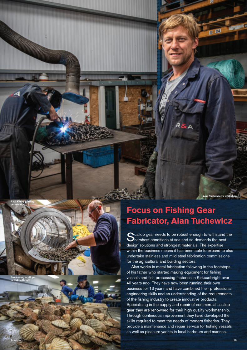
Focus on Fishing Gear Fabricator, Alan Tuchewicz
Scallop gear needs to be robust enough to withstand the harshest conditions at sea and so demands the best
design solutions and strongest materials. The expertise within the business means it has been able to expand to also undertake stainless and mild steel fabrication commissions for the agricultural and building sectors.
Alan works in metal fabrication following in the footsteps of his father who started making equipment for fishing vessels and fish processing factories in Kirkcudbright over 40 years ago. They have now been running their own business for 13 years and have combined their professional engineering skills and an understanding of the requirements of the fishing industry to create innovative products. Specialising in the supply and repair of commercial scallop gear they are renowned for their high quality workmanship. Through continuous improvement they have developed the skills required to meet the needs of modern fisheries. They provide a maintenance and repair service for fishing vessels as well as pleasure yachts in local harbours and marinas.
19
Alan Tuchewicz’s workshop
Paul Kenny grading periwinkles
Processing scallops in Kirkcudbright
20 Solway Firth Partnership
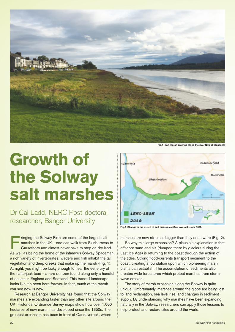
Fig.1 Salt marsh growing along the river Nith at Glencaple
Fig.2 Change in the extent of salt marshes at Caerlaverock since 1850.
Growth of the Solway salt marshes
Fringing the Solway Firth are some of the largest salt marshes in the UK – one can walk from Skinburness to Carsethorn and almost never have to step on dry land.
As well as being the home of the infamous Solway Spaceman, a rich variety of invertebrates, waders and fish inhabit the tall vegetation and deep creeks that make up the marsh (Fig. 1). At night, you might be lucky enough to hear the eerie cry of the natterjack toad – a rare denizen found along only a handful of coasts in England and Scotland. This tranquil landscape looks like it’s been here forever. In fact, much of the marsh you see now is new.
Research at Bangor University has found that the Solway marshes are expanding faster than any other site around the UK. Historical Ordnance Survey maps show how over 1,000 hectares of new marsh has developed since the 1850s. The greatest expansion has been in front of Caerlaverock, where
marshes are now six-times bigger than they once were (Fig. 2). So why this large expansion? A plausible explanation is that
offshore sand and silt (dumped there by glaciers during the Last Ice Age) is returning to the coast through the action of the tides. Strong flood-currents transport sediment to the coast, creating a foundation upon which pioneering marsh plants can establish. The accumulation of sediments also creates wide foreshores which protect marshes from storm-wave erosion.
The story of marsh expansion along the Solway is quite unique. Unfortunately, marshes around the globe are being lost to land reclamation, sea level rise, and changes in sediment supply. By understanding why marshes have been expanding naturally in the Solway, researchers can apply those lessons to help protect and restore sites around the world.
Dr Cai Ladd, NERC Post-doctoral researcher, Bangor University
21Tidelines
Governments around the world are declaring a global climate emergency and earlier this year, on the 15th May, I had the opportunity to hear the
Ministerial Statement on (and parliamentary discussion of) Scotland’s response to the global climate emergency. Scotland is now leading by example in its efforts to cut carbon emissions and I’m delighted that researchers at the University of St Andrews, working in partnership with the Scottish Blue Carbon Forum, are contributing to this debate and seeking-out novel nature-based solutions to help mitigate and adapt to the climate emergency.
Recently, the UK Committee on Climate Change has suggested that the UK can end its contribution to climate warming within 30 years by reducing greenhouse gas emissions to zero by 2050; the Scottish Government has pledged to end Scotland’s contribution to climate change by 2045.
Coastal habitats, such as saltmarshes, are important not only as places that can protect our coastlines from erosion,
they also provide grazing land for animals and support a rich biodiversity; they also offer highly effective carbon storage potential. These so-called Blue Carbon habitats are increasingly recognized as being particularly effective for long-term carbon storage while, at the same time, highly vulnerable to sea-level change. When degraded or poorly managed their potential to capture carbon is weakened and they can even become sources of carbon emissions back to the atmosphere. Their potential, to help us meet the ambitious targets of net zero emissions by 2045, therefore rests in their potential, when well-managed, to provide a long-term sink for atmospheric carbon dioxide.
Our team are leading a major UK-wide project called C-SIDE (www.c-side.org), where we are working in partnership with a much larger team of volunteer citizen scientists to quantify the carbon stocks in these saltmarsh habitats around the entire coastline of the UK. The stocks of carbon, many of them having taken thousands of years to accumulate in saltmarsh soils, are large and the potential for further gains, under appropriate management of our coastlines, significant. There is much to be gained from protecting our vulnerable coastal environments, Blue Carbon therefore adds a significant new dimension to the overall value of our coastal wetlands.
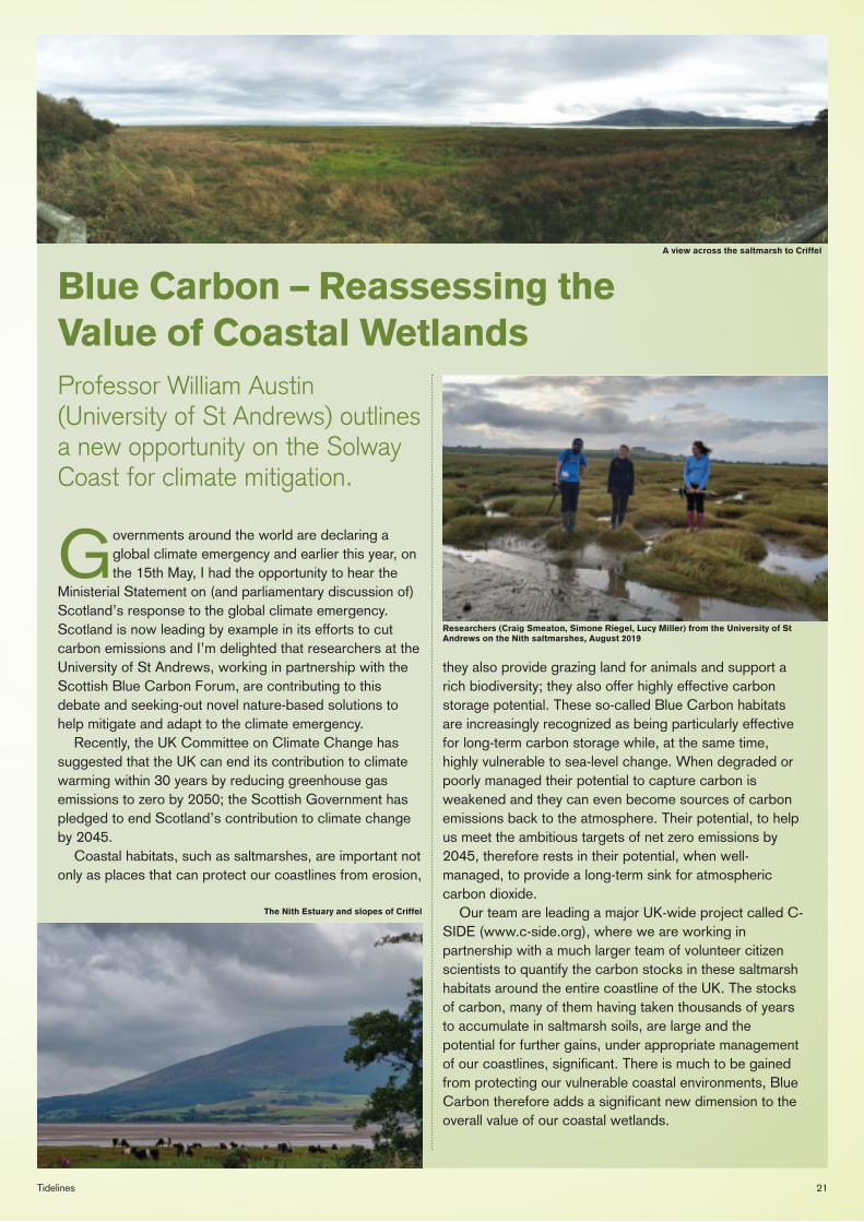
Blue Carbon – Reassessing the Value of Coastal WetlandsProfessor William Austin (University of St Andrews) outlines a new opportunity on the Solway Coast for climate mitigation.
The Nith Estuary and slopes of Criffel
Researchers (Craig Smeaton, Simone Riegel, Lucy Miller) from the University of St Andrews on the Nith saltmarshes, August 2019
A view across the saltmarsh to Criffel
22 Solway Firth Partnership
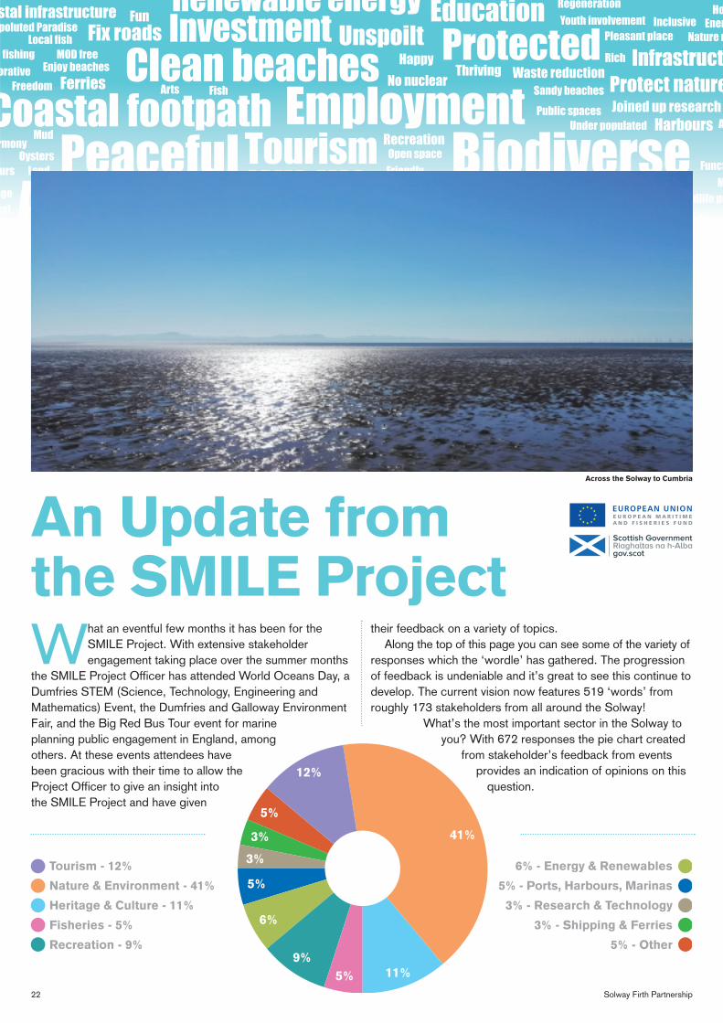
What an eventful few months it has been for the SMILE Project. With extensive stakeholder engagement taking place over the summer months
the SMILE Project Officer has attended World Oceans Day, a Dumfries STEM (Science, Technology, Engineering and Mathematics) Event, the Dumfries and Galloway Environment Fair, and the Big Red Bus Tour event for marine planning public engagement in England, among others. At these events attendees have been gracious with their time to allow the Project Officer to give an insight into the SMILE Project and have given
their feedback on a variety of topics. Along the top of this page you can see some of the variety of
responses which the ‘wordle’ has gathered. The progression of feedback is undeniable and it’s great to see this continue to develop. The current vision now features 519 ‘words’ from roughly 173 stakeholders from all around the Solway!
What’s the most important sector in the Solway to you? With 672 responses the pie chart created
from stakeholder’s feedback from events provides an indication of opinions on this
question.
E U R O P E A N M A R I T I M E A N D F I S H E R I E S F U N D
EUROPEAN UNIONAn Update from the SMILE Project
12%
5%
3%
3%
5%
6%
9%5%
41%
11%
Tourism - 12%
Nature & Environment - 41%
Heritage & Culture - 11%
Fisheries - 5%
Recreation - 9%
6% - Energy & Renewables
5% - Ports, Harbours, Marinas
3% - Research & Technology
3% - Shipping & Ferries
5% - Other
Across the Solway to Cumbria
23Tidelines
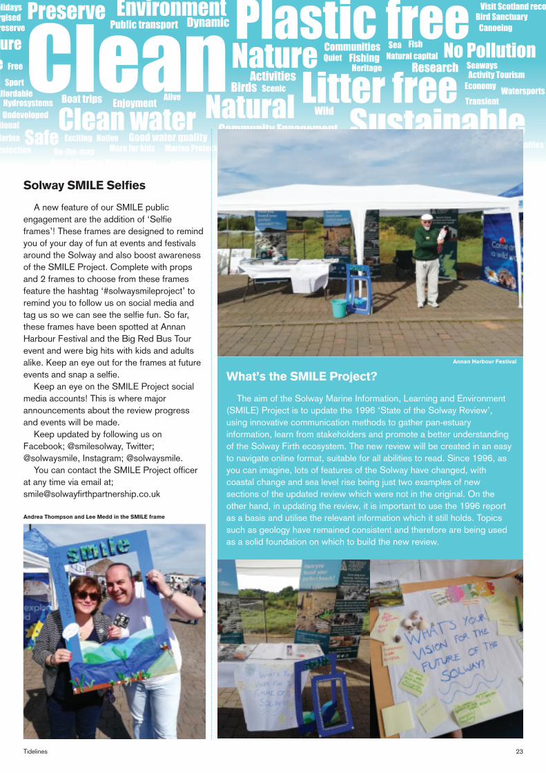
Solway SMILE Selfies
A new feature of our SMILE public engagement are the addition of ‘Selfie frames’! These frames are designed to remind you of your day of fun at events and festivals around the Solway and also boost awareness of the SMILE Project. Complete with props and 2 frames to choose from these frames feature the hashtag ‘#solwaysmileproject’ to remind you to follow us on social media and tag us so we can see the selfie fun. So far, these frames have been spotted at Annan Harbour Festival and the Big Red Bus Tour event and were big hits with kids and adults alike. Keep an eye out for the frames at future events and snap a selfie.
Keep an eye on the SMILE Project social media accounts! This is where major announcements about the review progress and events will be made.
Keep updated by following us on Facebook; @smilesolway, Twitter; @solwaysmile, Instagram; @solwaysmile.
You can contact the SMILE Project officer at any time via email at; [email protected]
What’s the SMILE Project?
The aim of the Solway Marine Information, Learning and Environment (SMILE) Project is to update the 1996 ‘State of the Solway Review’, using innovative communication methods to gather pan-estuary information, learn from stakeholders and promote a better understanding of the Solway Firth ecosystem. The new review will be created in an easy to navigate online format, suitable for all abilities to read. Since 1996, as you can imagine, lots of features of the Solway have changed, with coastal change and sea level rise being just two examples of new sections of the updated review which were not in the original. On the other hand, in updating the review, it is important to use the 1996 report as a basis and utilise the relevant information which it still holds. Topics such as geology have remained consistent and therefore are being used as a solid foundation on which to build the new review.
Annan Harbour Festival
Andrea Thompson and Lee Medd in the SMILE frame
24 Solway Firth Partnership
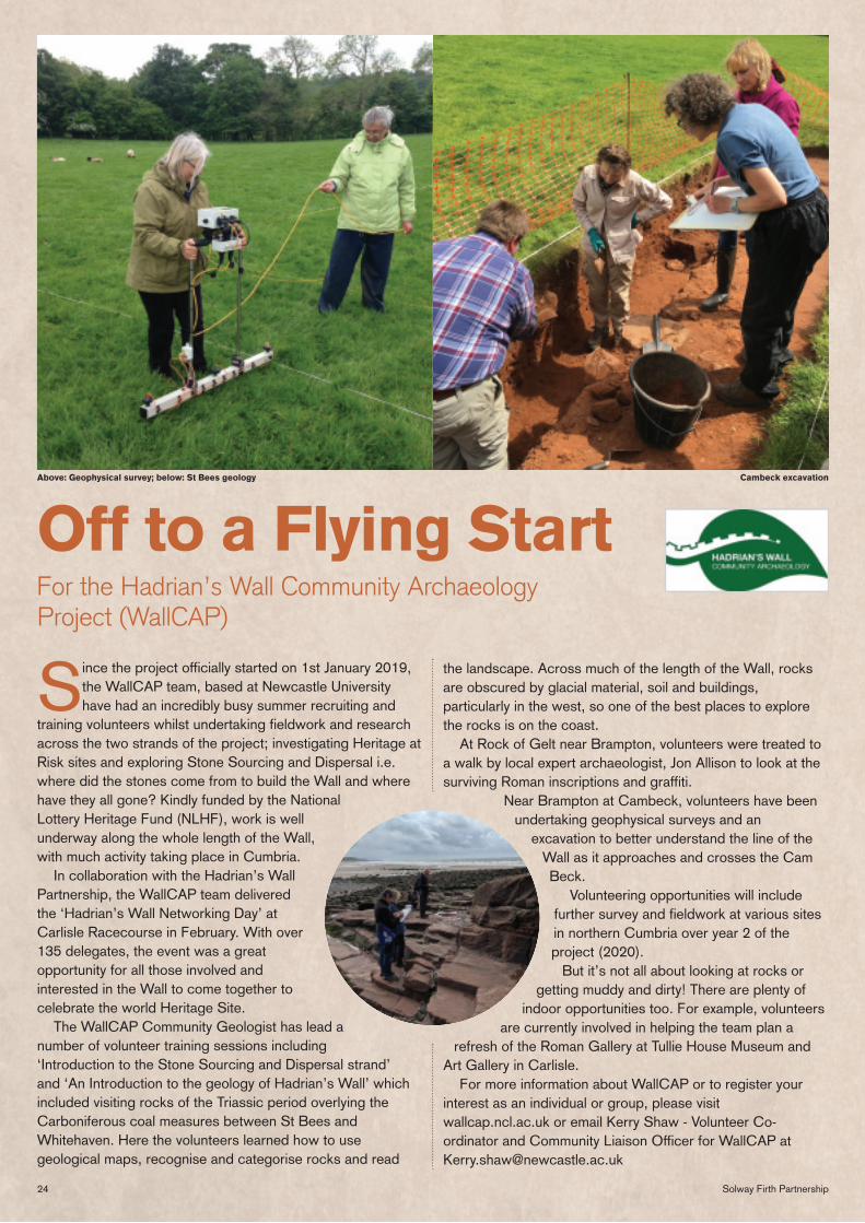
Since the project officially started on 1st January 2019, the WallCAP team, based at Newcastle University have had an incredibly busy summer recruiting and
training volunteers whilst undertaking fieldwork and research across the two strands of the project; investigating Heritage at Risk sites and exploring Stone Sourcing and Dispersal i.e. where did the stones come from to build the Wall and where have they all gone? Kindly funded by the National Lottery Heritage Fund (NLHF), work is well underway along the whole length of the Wall, with much activity taking place in Cumbria.
In collaboration with the Hadrian’s Wall Partnership, the WallCAP team delivered the ‘Hadrian’s Wall Networking Day’ at Carlisle Racecourse in February. With over 135 delegates, the event was a great opportunity for all those involved and interested in the Wall to come together to celebrate the world Heritage Site.
The WallCAP Community Geologist has lead a number of volunteer training sessions including ‘Introduction to the Stone Sourcing and Dispersal strand’ and ‘An Introduction to the geology of Hadrian’s Wall’ which included visiting rocks of the Triassic period overlying the Carboniferous coal measures between St Bees and Whitehaven. Here the volunteers learned how to use geological maps, recognise and categorise rocks and read
the landscape. Across much of the length of the Wall, rocks are obscured by glacial material, soil and buildings, particularly in the west, so one of the best places to explore the rocks is on the coast.
At Rock of Gelt near Brampton, volunteers were treated to a walk by local expert archaeologist, Jon Allison to look at the surviving Roman inscriptions and graffiti.
Near Brampton at Cambeck, volunteers have been undertaking geophysical surveys and an
excavation to better understand the line of the Wall as it approaches and crosses the Cam Beck.
Volunteering opportunities will include further survey and fieldwork at various sites in northern Cumbria over year 2 of the project (2020).
But it’s not all about looking at rocks or getting muddy and dirty! There are plenty of
indoor opportunities too. For example, volunteers are currently involved in helping the team plan a
refresh of the Roman Gallery at Tullie House Museum and Art Gallery in Carlisle.
For more information about WallCAP or to register your interest as an individual or group, please visit wallcap.ncl.ac.uk or email Kerry Shaw - Volunteer Co-ordinator and Community Liaison Officer for WallCAP at [email protected]
Off to a Flying StartFor the Hadrian’s Wall Community Archaeology Project (WallCAP)
Above: Geophysical survey; below: St Bees geology Cambeck excavation
25Tidelines
Robin Rigg Community Fund Now Open
Projects should support and promote any of the following causes: • Environmental • Renewable energy • Energy efficiency • Sustainable development • Charitable • Educational • Community • General community amenity
schemes or projects You can apply if your organisation is one of the following: • voluntary or community
organisation • registered charity • constituted group or club • not-for-profit company or
community interest company • social enterprise • school • parish and community council
that operates within the designated geographical area:-
Dumfries and Galloway: Caerlaverock New Abbey Kirkbean Southerness Colvend and Southwick Palnackie Auchencairn Dundrennan Kirkcudbright Borgue
Cumbria: Silloth on Solway Holme Low Holme St Cuthbert Allonby Hayton and Mealo Outerside and Allerby Crosscanonby Maryport Seaton Workington Filmby Distington Lowca Parton Whitehaven St Bees
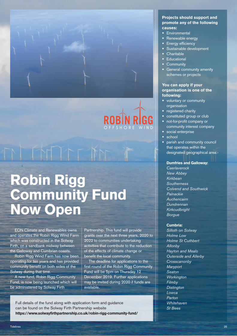
EON Climate and Renewables owns and operates the Robin Rigg Wind Farm which was constructed in the Solway Firth, on a sandbank midway between the Galloway and Cumbrian coasts.
Robin Rigg Wind Farm has now been operating for ten years and has provided community benefit on both sides of the Solway during that time.
A new fund, Robin Rigg Community Fund, is now being launched which will be administered by Solway Firth
Partnership. This fund will provide grants over the next three years, 2020 to 2022 to communities undertaking activities that contribute to the reduction of the effects of climate change or benefit the local community.
The deadline for applications to the first round of the Robin Rigg Community Fund will be 5pm on Thursday 12 December 2019. Further applications may be invited during 2020 if funds are available.
Full details of the fund along with application form and guidance can be found on the Solway Firth Partnership website https://www.solwayfirthpartnership.co.uk/robin-rigg-community-fund/
26 Solway Firth Partnership
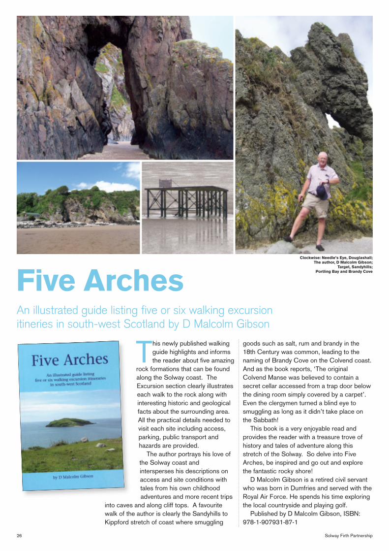
This newly published walking guide highlights and informs the reader about five amazing
rock formations that can be found along the Solway coast. The Excursion section clearly illustrates each walk to the rock along with interesting historic and geological facts about the surrounding area. All the practical details needed to visit each site including access, parking, public transport and hazards are provided.
The author portrays his love of the Solway coast and intersperses his descriptions on access and site conditions with tales from his own childhood adventures and more recent trips
into caves and along cliff tops. A favourite walk of the author is clearly the Sandyhills to Kippford stretch of coast where smuggling
goods such as salt, rum and brandy in the 18th Century was common, leading to the naming of Brandy Cove on the Colvend coast. And as the book reports, ‘The original Colvend Manse was believed to contain a secret cellar accessed from a trap door below the dining room simply covered by a carpet’. Even the clergymen turned a blind eye to smuggling as long as it didn’t take place on the Sabbath!
This book is a very enjoyable read and provides the reader with a treasure trove of history and tales of adventure along this stretch of the Solway. So delve into Five Arches, be inspired and go out and explore the fantastic rocky shore!
D Malcolm Gibson is a retired civil servant who was born in Dumfries and served with the Royal Air Force. He spends his time exploring the local countryside and playing golf.
Published by D Malcolm Gibson, ISBN: 978-1-907931-87-1
Five ArchesAn illustrated guide listing five or six walking excursion itineries in south-west Scotland by D Malcolm Gibson
Clockwise: Needle’s Eye, Douglashall; The author, D Malcolm Gibson;
Target, Sandyhills; Portling Bay and Brandy Cove
27Tidelines
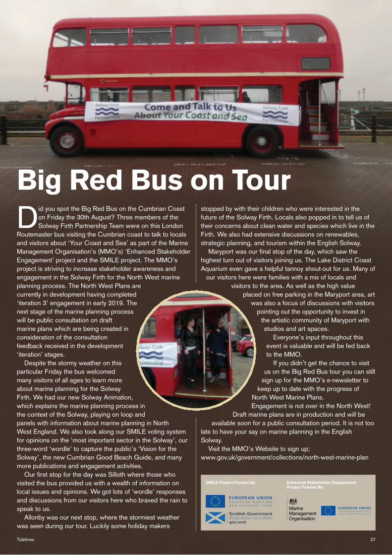
Did you spot the Big Red Bus on the Cumbrian Coast on Friday the 30th August? Three members of the Solway Firth Partnership Team were on this London
Routemaster bus visiting the Cumbrian coast to talk to locals and visitors about ‘Your Coast and Sea’ as part of the Marine Management Organisation’s (MMO’s) ‘Enhanced Stakeholder Engagement’ project and the SMILE project. The MMO’s project is striving to increase stakeholder awareness and engagement in the Solway Firth for the North West marine planning process. The North West Plans are currently in development having completed ‘iteration 3’ engagement in early 2019. The next stage of the marine planning process will be public consultation on draft marine plans which are being created in consideration of the consultation feedback received in the development ‘iteration’ stages.
Despite the stormy weather on this particular Friday the bus welcomed many visitors of all ages to learn more about marine planning for the Solway Firth. We had our new Solway Animation, which explains the marine planning process in the context of the Solway, playing on loop and panels with information about marine planning in North West England. We also took along our SMILE voting system for opinions on the ‘most important sector in the Solway’, our three-word ‘wordle’ to capture the public’s ‘Vision for the Solway’, the new Cumbrian Good Beach Guide, and many more publications and engagement activities.
Our first stop for the day was Silloth where those who visited the bus provided us with a wealth of information on local issues and opinions. We got lots of ‘wordle’ responses and discussions from our visitors here who braved the rain to speak to us.
Allonby was our next stop, where the stormiest weather was seen during our tour. Luckily some holiday makers
stopped by with their children who were interested in the future of the Solway Firth. Locals also popped in to tell us of their concerns about clean water and species which live in the Firth. We also had extensive discussions on renewables, strategic planning, and tourism within the English Solway.
Maryport was our final stop of the day, which saw the highest turn out of visitors joining us. The Lake District Coast Aquarium even gave a helpful tannoy shout-out for us. Many of
our visitors here were families with a mix of locals and visitors to the area. As well as the high value
placed on free parking in the Maryport area, art was also a focus of discussions with visitors
pointing out the opportunity to invest in the artistic community of Maryport with studios and art spaces.
Everyone’s input throughout this event is valuable and will be fed back to the MMO.
If you didn’t get the chance to visit us on the Big Red Bus tour you can still
sign up for the MMO’s e-newsletter to keep up to date with the progress of
North West Marine Plans. Engagement is not over in the North West!
Draft marine plans are in production and will be available soon for a public consultation period. It is not too
late to have your say on marine planning in the English Solway.
Visit the MMO’s Website to sign up; www.gov.uk/government/collections/north-west-marine-plan
Big Red Bus on Tour
SMILE Project Funded by; Enhanced Stakeholder Engagement Project Funded By;
E U R O P E A N M A R I T I M E A N D F I S H E R I E S F U N D
EUROPEAN UNION
E U R O P E A N M A R I T I M E A N D F I S H E R I E S F U N D
EUROPEAN UNION

28 Solway Firth Partnership
Solway Firth Partnership aims to undertake activities in line with our mission statement: To support a vibrant and sustainable local economy while respecting, protecting
and celebrating the distinctive character, heritage and natural features of our marine and coastal area.
Our accounts for the financial year end 31 March 2019 show
an income of £160,665 of Restricted and Unrestricted funds (£111,361 in the previous financial year) giving us a surplus of £11,708 in our Unrestricted funds. An Unrestricted Reserve of £73,729 is carried forward into the next financial year.
Projects completed this year included the Saving the Sparling Project (film, exhibition and leaflet) and the Solway Military Trail (website and self-guided leaflet). The SMILE (Solway Marine Information Learning and Environment) Project continues this year along with the SEASS / SEAES Project (Socio-Economic Analysis of the Scottish Solway and Socio-
Economic Analysis of the English Solway) all funded through the European Maritime and Fisheries Fund (through both Marine Scotland and the Marine Management Organisation). The Fishing Faces Project is well underway, aiming to raise awareness of the importance of commercial fishing to Dumfries and Galloway by highlighting personal stories that give an insight into the industry and Solway Coastwise is reaching an end having met all its targets both of which you can read more about in previous pages.
Our thanks go to the staff team who have worked hard to make the projects a success during the year.
We are very grateful to all the organisations that have provided funding in the last financial year: Marine Scotland, EON, Natural England, Cumbria County Council, Allerdale Borough Council, Carlisle City Council, Heritage Lottery Fund, Dumfries and Galloway LEADER Programme, Marine Management Organisation, European Maritime Fisheries Fund.
We would also like to thank all the people who have given in-kind support in many ways, thereby enabling our core activities to continue as well as allowing a wide range of projects to go ahead. We appreciate that Solway Firth Partnership relies on the goodwill and expertise of many people and organisations in order to be able to carry out the work we do.
Our full accounts for the last financial year are available on our website: www.solwayfirthpartnership.co.uk
Clair McFarlan: Solway Firth Partnership
Accounts to March 2019
Income
Marine Scotland 49%
Heritage Lottery Fund 25%
E-On 7%
Dumfries & Galloway Council 6%
LEADER 7%
Cumbria County Council 3%
Other Income 2%
Allerdale Borough Council 1%
Office Costs 8%
Communications 4%Other 1%
Governance <1%
Project Costs 37%
Staff Costs 49% Expenditure

29Tidelines
Daily throughout November ‘Differences between’ Trail (WWT Caerlaverock Wetland Centre) 10.00am to 5.00pm Booking: Not Essential
Discover the range of different waders that call our wetlands their home during the winter months and learn how to tell the difference between them! Contact: 01387 770200 or [email protected]
Meet: WWT Caerlaverock Wetland Centre, Eastpark Farm, Glencaple, DG1 4RS, NY052657
Cost: Normal admission charges apply, WWT members free.
Daily throughout November Robins and Rooks Exhibition (WWT Caerlaverock Wetland Centre) 10.00am to 5.00pm Booking: Not Essential
An exhibition of bird photography by 12-year old Viktor Seifert who has been shortlisted three times for the British Wildlife Photography Award. Viktor has been a keen photographer ever since he got his first camera for his fourth birthday. His fascination with wildlife photography started several years ago, during an inspiring stay at WWT Caerlaverock. He has returned regularly since, focussing on bird photography. Contact: 01387 770200 or [email protected]
Meet: WWT Caerlaverock Wetland Centre, Eastpark Farm, Glencaple, DG1 4RS, NY052657
Cost: Free
Saturday 2 November Blue Dial Beach Clean (Cumbria Wildlife Trust) 10.00am to 12.00noon Booking: Not Essential
When did you last lose a shoe? We find a few on every beach clean: trainers, wellies, high heels, novelty slippers and socks as well. Help us give rubbish the boot from our beautiful coast at this 2-hour event. Wear appropriate clothing and footwear. Contact: John Gorrill at [email protected]
Meet: Blue Dial Farm, Near Allonby, Cumbria, CA15 6PB
Cost: Free
Saturday 2 November Wader Watch (WWT Caerlaverock Wetland Centre) 11.00am to 3.00pm Booking: Essential
Take part in the World Wader Watch, to contribute to research on waders and see waders flocking in on the high tide. Andrew Whitelee from Wader Quest will give a talk on the World Wader Watch, 11am-12. Then there is a guided walk to see the waders on the reserve with the Reserve Manager, 1-3pm. We will look out for waders such as curlews, lapwings, knot, dunlin, golden plover and oystercatchers. Contact: 01387 770200 or [email protected]
Meet: WWT Caerlaverock Wetland Centre, Eastpark Farm, Glencaple, DG1 4RS, NY052657
Cost: Normal Admission charges apply, WWT members free
Sunday 3 November In Focus (WWT Caerlaverock Wetland Centre) 10.00am to 4.00pm Booking: Not Essential
Try before you buy the latest binoculars and telescopes from the huge range available today. In Focus experts on hand all day to give advice. WWT Caerlaverock benefits from every sale. Contact: 01387 770200 or [email protected]
Meet: WWT Caerlaverock Wetland Centre, Eastpark Farm, Glencaple, DG1 4RS, NY052657
Cost: Free
Tuesday 5 November Whitehaven Community Bonfire (Colourful Coast) 6.00pm to 8.00pm Booking: Not Essential
Come and join us for a cliff top bonfire high above Whitehaven where you get the best view of everyone else’s fireworks! Contact: Project Officer on 07342 088015 or email [email protected]
Meet: Cliff top above Whitehaven
Cost: Free
Friday 8 November Storytelling in the Yurt (WWT Caerlaverock Wetland Centre) 10.00am to 11.00am Booking: Essential
Sit in our cosy yurt and listen to a nature-related story told by one of our engaging storytellers. Then take a short walk around the reserve to look for some wildlife! Suitable for children aged 4 and under. All children must be accompanied by an adult. Contact: 01387 770200 or [email protected] to book a place
Meet: WWT Caerlaverock Wetland Centre, Eastpark Farm, Glencaple, DG1 4RS, NY052657
Cost: Normal admission charges apply, WWT members and children under 4 free
Sunday 10 November Dawn Flight (WWT Caerlaverock Wetland Centre) 6.30am Start Booking: Essential
Watch the amazing spectacle of thousands of wild barnacle geese flighting in from the mudflats against the dawn sky. The Cathan Coffee Shop will be open early to provide hot drinks and bacon rolls. Bring warm, waterproof clothing, binoculars and a torch. Contact: 01387 770200 or [email protected] to book a place
Meet: WWT Caerlaverock Wetland Centre, Eastpark Farm, Glencaple, DG1 4RS, NY052657
Cost: Normal admission charges apply, WWT members free
Whilst every effort is made to check the accuracy of the information given, Solway Firth Partnership cannot be held responsible for any inaccuracies or wrong information contained here and strongly recommends that you confirm details/arrangements/charges beforehand.
No
vem
ber
201
9 –
Mar
ch 2
020
Dat
es f
or
you
r D
iary NOVEMBER
Daily until Friday 15 Nov Scottish Nature Photography Exhib. (Logan Botanic Garden) 10.00am to 4.00pm Booking: Not Essential
See the stunning photgraphs of Scotland’s iconic coasts, wildlife and nature in this fabulous display of the finalists’ photographs. Contact: 01776 860231
Meet: Logan Studio @ Logan Botanic Garden, Port Logan, Stranraer, DG9 9ND
Cost: Free with normal garden entry
Daily until 23 November ‘Coastwise – where every name tells a story’ Exhib. (Dumfries Museum) 10.00am to 1.00pm and 2.00pm to 5.00pm (Tues to Sat) Booking: Not Essential
Revealing the history and stories behind the origins of coastal place-names by exploring the language used to describe features between Redkirk Point and Southerness. Using the first Ordnance Survey maps, the exhibition looks at how names have evolved and explains the meaning of words that have disappeared from our everyday language. Contact: 01387 253374. Find out more at www.solwayfirthpartnership. co.uk/community/solwaycoastwise
Meet: Dumfries Museum, The Observatory, Rotchell Road, Dumfries, DG2 7SW
Cost: Free
Daily until 23 November Plastic Waste Art Installation (Dumfries Museum) 10.00am to 1.00pm and 2.00pm to 5.00pm (Tues to Sat) Booking: Not Essential
The For Enjoyment community were commissioned by the Dumfries and Galloway Eco Warriors to produce an installation piece that would highlight the effects of plastic pollution on the Dumfries and Galloway coastline. The resulting art work invites debate about the human impact of our natural world and at the same time highlight the importance of the work of the Eco Warriors in attempting to clean up our precious beaches. Contact: 01387 253374
Meet: Dumfries Museum, The Observatory, Rotchell Road, Dumfries, DG2 7SW
Cost: Free
Daily throughout November Wild Swan Feeds (WWT Caerlaverock Wetland Centre) 11.00am and 2.00pm Booking: Not Essential
Experience the sights and sounds of hundreds of whooper swans, mute swans, ducks and geese at the daily swans feeds. Use the touchscreen in the Sir Peter Scott Observatory to find out more about the individual whooper swans out on the Whooper pond. Contact: 01387 770200 or [email protected]
Meet: WWT Caerlaverock Wetland Centre, Eastpark Farm, Glencaple, DG1 4RS, NY052657
Cost: Normal admission charges apply, WWT members free.

30 Solway Firth Partnership
Sunday 10 November Mersehead Beach Clean (RSPB Mersehead Nature Reserve) 10.00am to 2.00pm Booking: Not Essential
We need your help to clean our shores! Plastic pollution is drastic for our marine life and seabirds. We are removing the washed up waste on our 3.2 mile shoreline, and welcome you to join us on the clean-up. Please bring your own GLOVES, waterproofs, sturdy footwear and a packed lunch (if staying for the day). Booking not essential but please let us know if you’re planning to come. Contact: 01387 780579 or [email protected]
Meet: RSPB Mersehead Nature Reserve, Southwick, Dumfries, DG2 8AH
Cost: FREE normal car parking charges do not apply for this event
Sunday 10 November Sunset on the Solway (RSPB Mersehead Nature Reserve) 4.30pm to 6.00pm Booking: Essential
Some of the greatest spectacles of nature take place at dusk. Join our guide in the hide to enjoy an air show of starlings in murmuration or geese descending on reserve to roost. We'll have an infra-red camera and telescope on hand to help you spot wildlife too, as the light drops. Contact: 01387 780579 or [email protected]
Meet: RSPB Mersehead Nature Reserve, Southwick, Dumfries, DG2 8AH
Cost: Adults £4 (RSPB members £3), Children half price. Car parking charges apply for non-members.
Tuesday 12 November Logan’s Last Tour (Logan Botanic Garden) 10.30am to 2.00pm Booking: Not Essential
Enjoy the final guided tour of the season before the garden closes for winter. Contact: 01776 860231
Meet: Logan Garden (outdoor) @ Logan Botanic Garden, Port Logan, Stranraer, DG9 9ND
Cost: Included with normal garden entry
Thursday 14 November Autumn Discovery Walk (RSPB Mersehead Nature Reserve) 11.00am to 1.00pm Booking: Essential
Every fortnight from 5 September to 28 November, discover some of the amazing wildlife looked after on this farm. As the season changes, so too do the habitats and special creatures found here - from lush greens to gold, reds and browns and nature's harvest to first arrivals from the Arctic. These walks will give you a chance to see it all close-up and learn how we manage this important place for nature in our fields and on the wetlands. Contact: 01387 780579 or [email protected]
Meet: RSPB Mersehead Nature Reserve, Southwick, Dumfries, DG2 8AH
Cost: £4 Adults, £2 Children (£3 and £1.50 for RSPB Members)
Friday 6 December Festive Stories in the Yurt (WWT Caerlaverock Wetland Centre) 10.00am to 11.00am Booking: Essential
Sit in our cosy yurt and listen to a festive nature-related story. Then take a short walk around the reserve to look for some wildlife! Suitable for aged 4 and under. All children must be accompanied by an adult. Contact: 01387 770200 or [email protected] to book a place
Meet: WWT Caerlaverock Wetland Centre, Eastpark Farm, Glencaple, DG1 4RS, NY052657
Cost: Normal admission charges apply, WWT members free
Saturday 7 December Christmas Craft Afternoon (WWT Caerlaverock Wetland Centre) 1.00pm to 3.00pm Booking: Essential
Using natural materials make your own festive crafts in time for Christmas! Suitable for all ages! Contact: 01387 770200 or [email protected]
Meet: WWT Caerlaverock Wetland Centre, Eastpark Farm, Glencaple, DG1 4RS, NY052657
Cost: Normal admission charges apply, WWT members free. There will also be a small charge for materials.
Sunday 8 December Mersehead Beach Clean (RSPB Mersehead Nature Reserve) 10.00am to 2.00pm Booking: Not Essential
See 10 November’s event.
Sunday 8 December Sunset on the Solway (RSPB Mersehead Nature Reserve) 3.30pm - 5.00pm Booking: Essential
See 10 November’s event.
Wednesday 11 December Conservation day at Drumburgh Moss Nature Reserve (Cumbria Wildlife Trust) 10.00am to 3.30pm Booking: Essential
See 26 November’s event.
Thursday 12 December Winter Discovery Walk (RSPB Mersehead Nature Reserve) 11.00am to 1.00pm Booking: Essential
As the season changes, so too do the habitats and special creatures found here - from plants and trees shutting down for winter to birds flocking in their masses. These walks will give you a chance to see it all close-up and learn how we manage this important place for nature in our fields and on the wetlands Contact: 01387 780579 or [email protected]
Meet: RSPB Mersehead Nature Reserve, Southwick, Dumfries, DG2 8AH
Cost: £4 Adults, £2 Children (£3 and £1.50 for RSPB Members)
Thursday 28 November St Bees Beach Clean (St Bees) 10.30am to 12.00noon Booking: Not Essential
Join the Colourful Coast team on this litter pick on St Bee’s beach. You will be provided with all the equipment you’ll need (litter pickers, bin bags, gloves, sometimes even biscuits!). Boots or wellies are recommended. Please dress according to the weather (raincoat, suncream, sunhat). Contact: Project Officer on 07342088015 or email [email protected]
Meet: St Bees, main beach car park, behind the lifeboat station, NX961117
Cost: Free
Thursday 28 November Autumn Discovery Walk (RSPB Mersehead Nature Reserve) 11.00am to 1.00pm Booking: Essential
See 14 November’s event.
DECEMBER Daily throughout December (apart from Christmas Day) Wild Swan Feeds (WWT Caerlaverock Wetland Centre) 11.00am and 2.00pm Booking: Not Essential
See details in November’s event.
Daily throughout December Robins and Rooks Exhibition (WWT Caerlaverock Wetland Centre) 10.00am to 5.00pm Booking: Not Essential
See details in November’s event.
Sunday 1 December Dawn Flight (WWT Caerlaverock Wetland Centre) 7.00am Start Booking: Essential
See 10 November’s event.
Wednesday 4 December Conservation day at Bowness on Solway Nature Reserve (Cumbria Wildlife Trust) 10.00am to 3.30pm Booking: Essential
Join Cumbria Wildlife Trust to carry out some scrub clearance and other maintenance works. Bowness-on-Solway is an old gravel pit that has become a wonderful site for wildlife. Wear appropriate clothing and footwear and bring refreshments and packed lunch. Contact: CWT, call 01539 816300 or [email protected]
Meet: Bowness on Solway Nature Reserve, near the village, Carlisle, Cumbria, CA7 5AQ. Meet at the reserve entrance gate GR: NY206617
Cost: Free
Saturday 16 November High-Tide Guided Walk (RSPB Crook of Baldoon) 12noon to 2.00pm Booking: Essential
A leisurely walk and look at the two lagoons and the saltmarsh to see what wildlife we can see. Boots or wellies and bring the binoculars if you have them. Contact: 01988 402130 or [email protected]
Meet: Shell Rd, Newton Stewart DG8 9AF
Cost: £4 for members and £5 for non-members
Saturday 17 November Wildlife Photography Workshop (WWT Caerlaverock Wetland Centre) 9.30am to 4.00pm Booking: Essential
Wildlife photography workshop with Tom Langlands and Bob Fitzsimmons. Learn how to take fantastic shots of the swans, geese and ducks on this wonderful wetland reserve. All abilities welcome - suitable for beginners to more experienced photographers. Contact: 01387 770200 or [email protected] to book a place
Meet: WWT Caerlaverock, Eastpark Farm, Caerlaverock, Dumfriesshire, Scotland, DG1 4RS
Cost: £75 per person (gift vouchers are available)
Sunday 24 November Sunset on the Solway (RSPB Mersehead Nature Reserve) 4.00pm to 5.30pm Booking: Essential
See 10 November’s event.
Tuesday 26 November Conservation day at Drumburgh Moss Nature Reserve (Cumbria Wildlife Trust) 10.00am to 3.30pm Booking: Essential
Join Cumbria Wildlife Trust to construct a boardwalk to create a new route of access on this National Nature Reserve. Drumburgh Moss is an important raised mire, part of the South Solway Special Area of Conservation. Wear appropriate clothing and footwear and bring refreshments and packed lunch. Contact: CWT, call 01539 816300 or [email protected]
Meet: Drumburgh Moss, Near Drumburgh village, Cumbria, CA7 5DR. Meet at the car park up from Moss Cottage. GR: NY255591
Cost: Free

31Tidelines
JANUARY ’20 Daily throughout January Wild Swan Feeds (WWT Caerlaverock Wetland Centre) 11.00am and 2.00pm Booking: Not Essential
See details in November’s event.
Daily until 27 January 'From Woods to Water' Exhibition (WWT Caerlaverock Wetland Centre) 10.00am to 5.00pm Booking: Not Essential
See 15 December’s event.
Daily throughout January Feather Trail (WWT Caerlaverock Wetland Centre) 10.00am to 5.00pm Booking: Not Essential
Follow the trail signs to identify feathers commonly found on the reserve. Contact: 01387 770200 or [email protected]
Meet: WWT Caerlaverock Wetland Centre, Eastpark Farm, Glencaple, DG1 4RS, NY052657
Cost: Normal admission charges, WWT members free.
Thursday 9 & 23 January Winter Discovery Walk (RSPB Mersehead Nature Reserve) 11.00am to 1.00pm Booking: Essential
See 12 December’s event.
Sun 26 Jan to Fri 31 Jan ‘Alla Prima Studies in Nature’ Exhibition (WWT Caerlaverock Wetland Centre) 10.00am to 5.00pm Booking: Not Essential
The work for this exhibition is the artist’s response to local wildlife and an attempt to capture their essence. Most encounters with nature are short and fleeting and these works aim to capture and record them. The work is the culmination of many visits to the centre and its surrounding countryside. Alla Prima translated directly from Italian means all at once and refers specifically to the artist’s painting method. Paintings are done in one session working fast and spontaneous. This means there is always an element of surprise and controlled experimentation to the work which hopefully creates a sense of energy and excitement. The paintings are in Acrylic on both canvas and paper. Contact: 01387 770200 or [email protected]
Meet: WWT Caerlaverock Wetland Centre, Eastpark Farm, Glencaple, DG1 4RS, NY052657
Cost: Free
Tues 28 January Solway Firth Partnership Talk (Devil’s Porridge Museum) 7.00pm Booking: TBC
Come along to this talk about Solway Firth Partnership, our work, projects, and moving forward. This talk will be given by our SMILE project officer and will feature the SMILE project and other aspects of past and ongoing work at Solway Firth Partnership. Contact: 01461 700021 or email [email protected]
Meet: The Devil’s Porridge Museum, Stanfield Road, Eastriggs, Dumfries and Galloway, DG12 6TF
Cost: £3 per person
FEBRUARY Daily throughout February Wild Swan Feeds (WWT Caerlaverock Wetland Centre) 11.00am and 2.00pm Booking: Not Essential
See details in November’s event.
Daily throughout February ‘Alla Prima Studies in Nature’ Exhibition (WWT Caerlaverock Wetland Centre) 10.00am to 5.00pm Booking: Not Essential
See 26 January’s event.
Thursday 6 & 20 February Winter Discovery Walk (RSPB Mersehead Nature Reserve) 11.00am to 1.00pm Booking: Essential
See 12 December’s event.
Sunday 16 February Bird Trapping & Ringing Demonstration (RSPB Mersehead Nature Reserve) 10.00am to 1.00pm Booking: Not Essential
North Solway Bird Ringing Group ringing demonstrations give people a rare chance to experience our songbirds up close. You never know what you might see, from greenfinches or blue tits, to the rarer yellowhammers or tree sparrows! Discover what secrets the ringing finds out about these birds and maybe help to release them back into the wild. With birdy activity for kids to complete on the day. Contact: 01387 780579 or [email protected]
Meet: RSPB Mersehead Nature Reserve, Southwick, Dumfries, DG2 8AH
Cost: FREE but donations welcome, to help us look after the reserve and nature. Car parking charges apply for non-members.
Saturday 22 February Badger Banquet (RSPB Mersehead Nature Reserve) 7.00pm to 8.30pm Booking: Essential (max 12)
Feast your eyes on badgers, as they snuffle around for a snack in our garden. These creatures are living on the reserve and often leave tracks and signs along our trails but close views can be a challenge. Watch them from the comfort of our Sulwath Centre, with hot drinks also available for the evening. Who knows what else might turn up? Contact: 01387 780579 or [email protected]
Meet: RSPB Mersehead Nature Reserve, Southwick, Dumfries, DG2 8AH
Cost: £12 (RSPB members £10), Children half price. (car parking charge does not apply).
Saturday 29 February CBDC Recorders Conference (Cumbria Biodiversity Data Centre) Booking: Essential
Save the Date! The new date will allow everyone time to process 2019 records and provide an opportunity for "hot off the press" reports and presentations. Contact: 01228 618732 or [email protected]
Meet: TBC
Cost: TBC
MARCH Daily throughout March Wild Swan Feeds (WWT Caerlaverock Wetland Centre) 11.00am and 2.00pm Booking: Not Essential
See details in November’s event.
Sun 1 to Sat 7 March ‘Alla Prima Studies in Nature’ Exhibition (WWT Caerlaverock Wetland Centre) 10.00am to 5.00pm Booking: Not Essential
See 26 January’s event.
Thursday 5 & 19 March Spring Discovery Walk (RSPB Mersehead Nature Reserve) 11.00am to 1.00pm Booking: Essential
Discover some of the amazing wildlife looked after on this farm. As the season changes, so too do the habitats and special creatures found here - from emerging insects to chicks hatching, the first flowers and departing geese. These walks will give you a chance to see it all close-up and learn how we manage this important place for nature in our fields and on the wetlands. Contact: 01387 780579 or [email protected]
Meet: RSPB Mersehead Nature Reserve, Southwick, Dumfries, DG2 8AH
Cost: £4 Adults, £2 Children (£3 and £1.50 for RSPB Members)
Saturday 14 December High-Tide Guided Walk (RSPB Crook of Baldoon) 12noon to 2.00pm Booking: Essential
See 16 November’s event.
Sun 15 Dec to Tues 31 Dec ‘From Woods to Water’ Exhibition (WWT Caerlaverock Wetland Centre) 10.00am to 5.00pm Booking: Not Essential
Kerry Thomas is an artist and maker based near Lockerbie. In this exhibition, Kerry has created a collection of pictures using the themes of woods and water. She specialises in creating pictures using wool and other fibres in a process called needle-felting. Her work in this media is mainly landscapes, seascapes and woodland scenes, and each of her pieces is original artwork, including each greetings card. Her other work on exhibition here is in mixed media, using mainly watercolours in a more abstract form but also based on the theme of landscapes. Contact: 01387 770200 or [email protected]
Meet: WWT Caerlaverock Wetland Centre, Eastpark Farm, Glencaple, DG1 4RS, NY052657
Cost: Free
Thursday 19 December Whitehaven Beach Clean (Whitehaven) 10.30am to 12.00noon Booking: Not Essential
Join the Colourful Coast team on this litter pick on Whitehaven beach. You will be provided with all the equipment you’ll need (litter pickers, bin bags, gloves, sometimes even biscuits!). Boots or wellies are recommended. Please dress according to the weather (raincoat, suncream, sunhat). Contact: Project Officer on 07342 088015 or email [email protected]
Meet: Meet in Whitehaven at the top of the slipway near the parking machines on North Shore, behind Tesco.
Cost: Free
Thursday 26 December Boxing Day Discovery Walk (RSPB Mersehead Nature Reserve) 11.00am to 1.00pm Booking: Essential
Stretch your legs after a festive day and discover some of the amazing wildlife looked after on this farm. Get closer views of our waders, ducks and wintering gaggles of geese or glimpses of finches, sparrows and buntings foraging in the fields. We'll have a telescope in hand, to enhance viewing, as you learn how we manage this important place for nature in our fields and on the wetlands. (Note: bookings must be made before 24 December. This walk will only take place if sufficent numbers are booked in advance). Contact: 01387 780579 or [email protected]
Meet: RSPB Mersehead Nature Reserve, Southwick, Dumfries, DG2 8AH
Cost: £4 Adults, £2 Children (£3 and £1.50 for RSPB Members)
For further information, to submit an article or to join the SFP mailing list please contact: Solway Firth Partnership, Campbell House, The Crichton, Bankend Road, Dumfries, DG1 4UQ t: 01387 702161 e: [email protected] www.solwayfirthpartnership.co.uk To subscribe to the Solway Firth Partnership Newsletter please visit: www.solwayfirthpartnership.co.uk The Solway Firth Partnership is a Scottish Company Limited by guarantee and without share capital under Company Number SC250012 and a Scottish Charity under Scottish Charity Number SCO34376. Registered office: Campbell House, The Crichton, Dumfries DG1 4UQ Published by Solway Firth Partnership. Designed by Findlay Design. Print by FP Commercial Print, Stranraer.


![Title 51 RCW - Washingtonleg.wa.gov › CodeReviser › RCWArchive › Documents › 2018 › Title 51...(2018 Ed.) [Title 51 RCW—page 1] Title 51 Title 51 51 INDUSTRIAL INSURANCE](https://static.fdocuments.us/doc/165x107/5f13739b25d6831c263b508b/title-51-rcw-a-codereviser-a-rcwarchive-a-documents-a-2018-a-title-51.jpg)


