The Rise of Guerilla Journalism - and the implications for journalism education
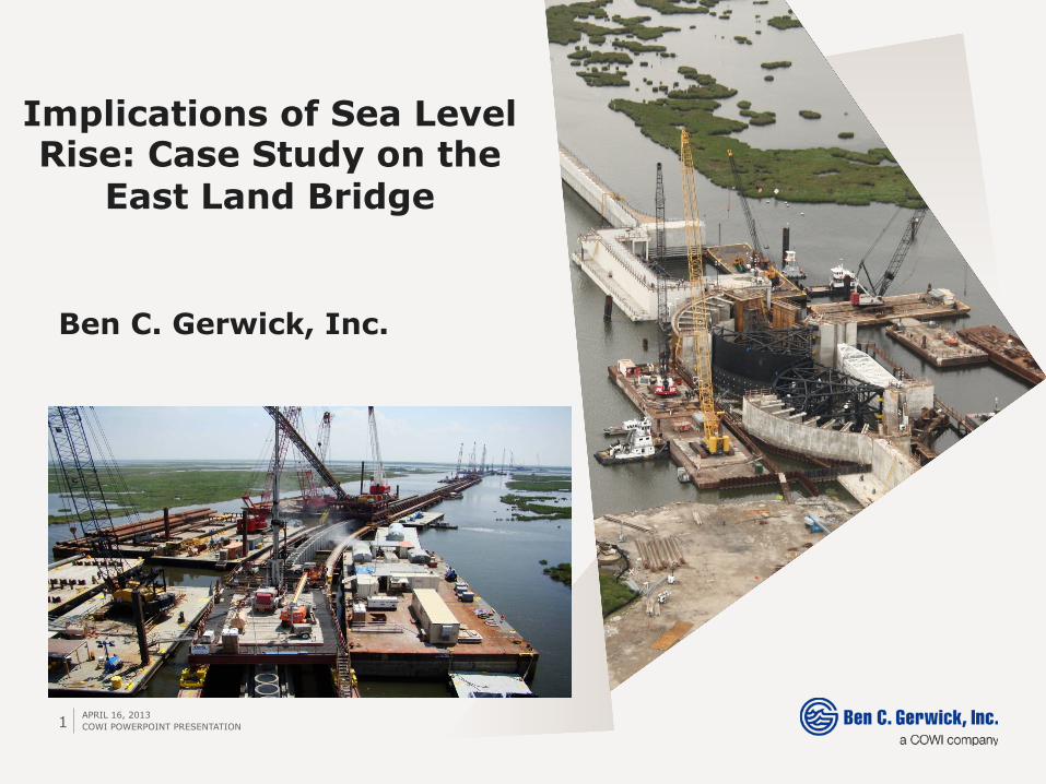
APRIL 16, 2013 COWI POWERPOINT PRESENTATION 1
Ben C. Gerwick, Inc.
Implications of Sea Level Rise: Case Study on the
East Land Bridge
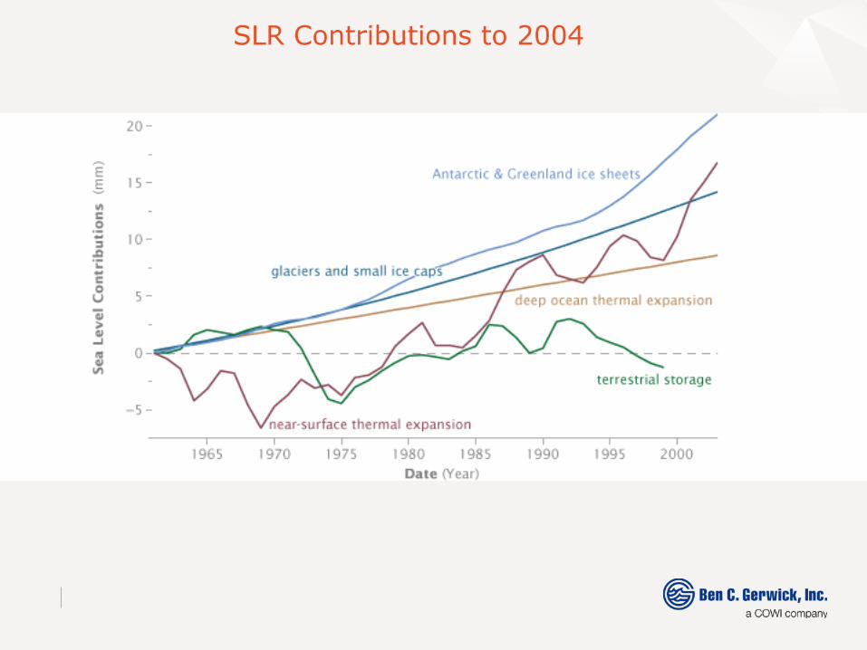
SLR Contributions to 2004
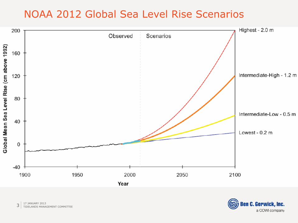
NOAA 2012 Global Sea Level Rise Scenarios
17 JANUARY 2013 TIDELANDS MANAGEMENT COMMITTEE 3
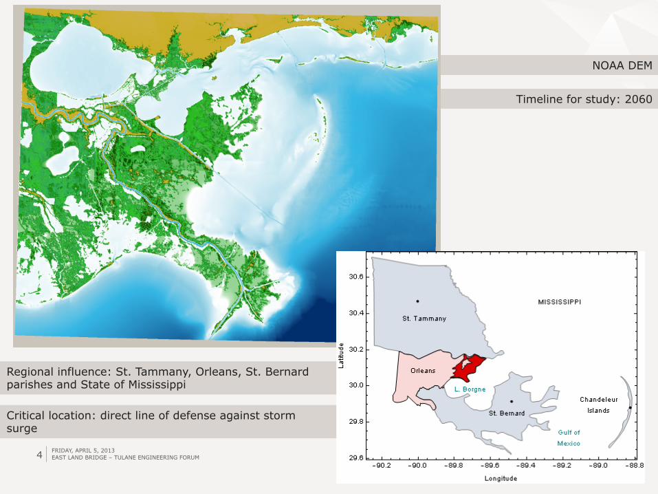
Timeline for study: 2060
NOAA DEM
4
Critical location: direct line of defense against storm surge
Regional influence: St. Tammany, Orleans, St. Bernard parishes and State of Mississippi
FRIDAY, APRIL 5, 2013 EAST LAND BRIDGE – TULANE ENGINEERING FORUM
5
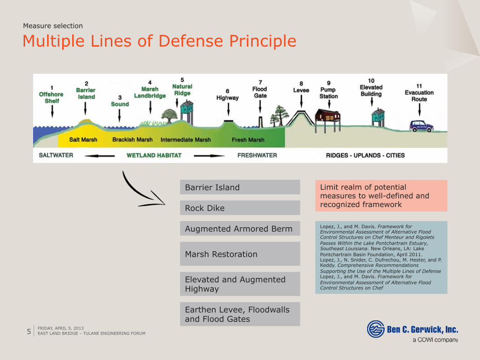
Multiple Lines of Defense Principle Measure selection
Barrier Island
Marsh Restoration
Rock Dike
Augmented Armored Berm
Elevated and Augmented Highway
Earthen Levee, Floodwalls and Flood Gates
Limit realm of potential measures to well-defined and recognized framework
Lopez, J., and M. Davis. Framework for Environmental Assessment of Alternative Flood Control Structures on Chef Menteur and Rigolets Passes Within the Lake Pontchartrain Estuary, Southeast Louisiana. New Orleans, LA: Lake Pontchartrain Basin Foundation, April 2011. Lopez, J., N. Snider, C. Dufrechou, M. Hester, and P. Keddy. Comprehensive Recommendations Supporting the Use of the Multiple Lines of Defense Lopez, J., and M. Davis. Framework for Environmental Assessment of Alternative Flood Control Structures on Chef
FRIDAY, APRIL 5, 2013 EAST LAND BRIDGE – TULANE ENGINEERING FORUM

6
East Land Bridge, New Orleans, LA
› Challenges › ›
Challenges › Viability and long-term value of
various shoreline protection schemes › Inundation/flooding from combined action of SLR and tidal events Shoreline erosion
threaten entire project ›
Coastal areas and navigational structures Coastal areas and
Flooding
High-crested structures
FRIDAY, APRIL 5, 2013 EAST LAND BRIDGE – TULANE ENGINEERING FORUM
7
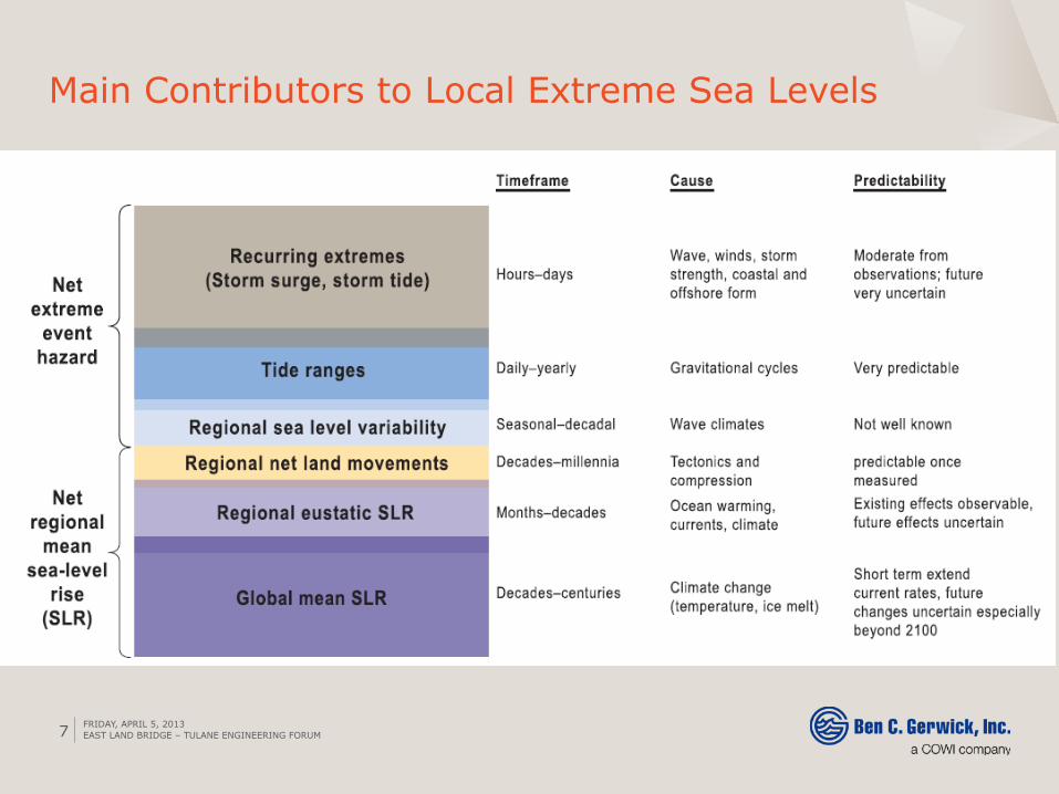
Main Contributors to Local Extreme Sea Levels
FRIDAY, APRIL 5, 2013 EAST LAND BRIDGE – TULANE ENGINEERING FORUM
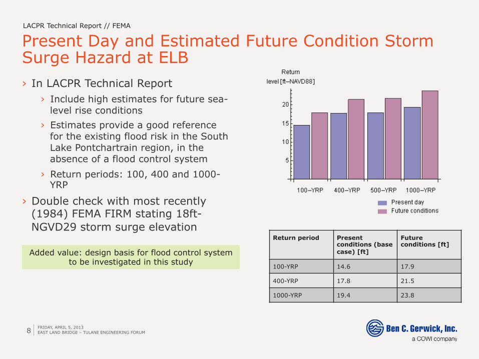
Present Day and Estimated Future Condition Storm Surge Hazard at ELB
8
› In LACPR Technical Report › Include high estimates for future sea-
level rise conditions › Estimates provide a good reference
for the existing flood risk in the South Lake Pontchartrain region, in the absence of a flood control system
› Return periods: 100, 400 and 1000-YRP
› Double check with most recently (1984) FEMA FIRM stating 18ft-NGVD29 storm surge elevation
LACPR Technical Report // FEMA
Return period Present conditions (base case) [ft]
Future conditions [ft]
100-YRP 14.6 17.9
400-YRP 17.8 21.5
1000-YRP 19.4 23.8
Added value: design basis for flood control system to be investigated in this study
FRIDAY, APRIL 5, 2013 EAST LAND BRIDGE – TULANE ENGINEERING FORUM
9
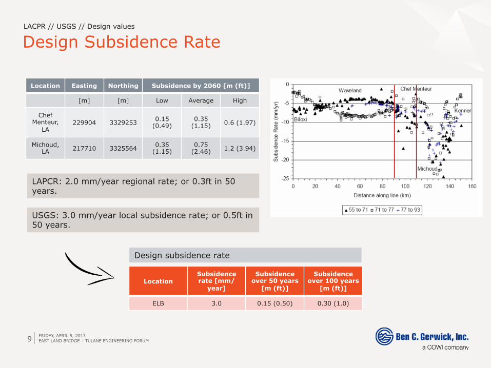
Design Subsidence Rate LACPR // USGS // Design values
Location Easting Northing Subsidence by 2060 [m (ft)]
[m] [m] Low Average High
Chef Menteur,
LA 229904 3329253 0.15
(0.49) 0.35
(1.15) 0.6 (1.97)
Michoud, LA 217710 3325564 0.35
(1.15) 0.75
(2.46) 1.2 (3.94)
Location Subsidence rate [mm/
year]
Subsidence over 50 years
[m (ft)]
Subsidence over 100 years
[m (ft)]
ELB 3.0 0.15 (0.50) 0.30 (1.0)
LAPCR: 2.0 mm/year regional rate; or 0.3ft in 50 years.
USGS: 3.0 mm/year local subsidence rate; or 0.5ft in 50 years.
Design subsidence rate
FRIDAY, APRIL 5, 2013 EAST LAND BRIDGE – TULANE ENGINEERING FORUM
10
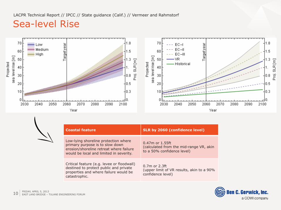
Sea-level Rise LACPR Technical Report // IPCC // State guidance (Calif.) // Vermeer and Rahmstorf
Coastal feature SLR by 2060 (confidence level)
Low-lying shoreline protection where primary purpose is to slow down erosion/shoreline retreat where failure would be local and limited in severity.
0.47m or 1.55ft (calculated from the mid-range VR, akin to a 50% confidence level)
Critical feature (e.g. levee or floodwall) destined to protect public and private properties and where failure would be catastrophic.
0.7m or 2.3ft (upper limit of VR results, akin to a 90% confidence level)
FRIDAY, APRIL 5, 2013 EAST LAND BRIDGE – TULANE ENGINEERING FORUM
11
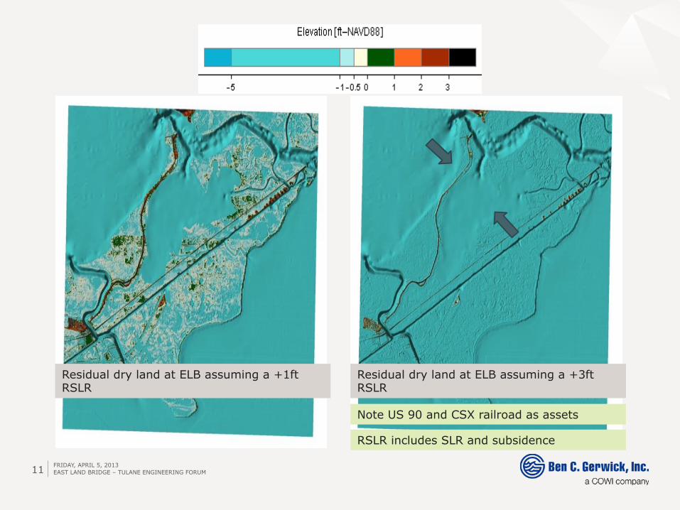
Residual dry land at ELB assuming a +1ft RSLR
Residual dry land at ELB assuming a +3ft RSLR
Note US 90 and CSX railroad as assets
RSLR includes SLR and subsidence
FRIDAY, APRIL 5, 2013 EAST LAND BRIDGE – TULANE ENGINEERING FORUM
FRIDAY, APRIL 5, 2013 12
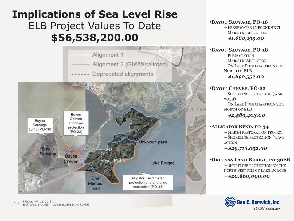
Implications of Sea Level Rise ELB Project Values To Date
$56,538,200.00
EAST LAND BRIDGE – TULANE ENGINEERING FORUM
§ BAYOU SAUVAGE, PO-16 ― FRESHWATER IMPOUNDMENT ― MARSH RESTORATION ― $1,680,193.00
§ BAYOU SAUVAGE, PO-18 ― PUMP STATION ― MARSH RESTORATION ― ON LAKE PONTCHARTRAIN SIDE, NORTH OF ELB ― $1,692,552.00
§ BAYOU CHEVEE, PO-22 ― SHORELINE PROTECTION (WAKE WASH) ― ON LAKE PONTCHARTRAIN SIDE, NORTH OF ELB ― $2,589,403.00
§ ALLIGATOR BEND, PO-34 ― MARSH RESTORATION PROJECT ― SHORELINE PROTECTION (WAVE ACTION) ― $29,716,052.00
§ ORLEANS LAND BRIDGE, PO-36EB ― SHORELINE PROTECTION ON THE NORTHWEST RIM OF LAKE BORGNE ― $20,860,000.00
FRIDAY, APRIL 5, 2013 13
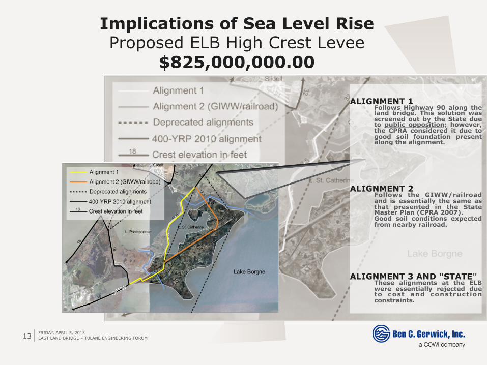
Implications of Sea Level Rise Proposed ELB High Crest Levee
$825,000,000.00
EAST LAND BRIDGE – TULANE ENGINEERING FORUM
ALIGNMENT 1 Follows Highway 90 along the land bridge. This solution was screened out by the State due to public opposition; however, the CPRA considered it due to good soil foundation present along the alignment. ALIGNMENT 2 Follows the GIWW/railroad and is essentially the same as that presented in the State Master Plan (CPRA 2007). Good soil conditions expected from nearby railroad. ALIGNMENT 3 AND "STATE" These alignments at the ELB were essentially rejected due to cost and construction constraints.
FRIDAY, APRIL 5, 2013 14
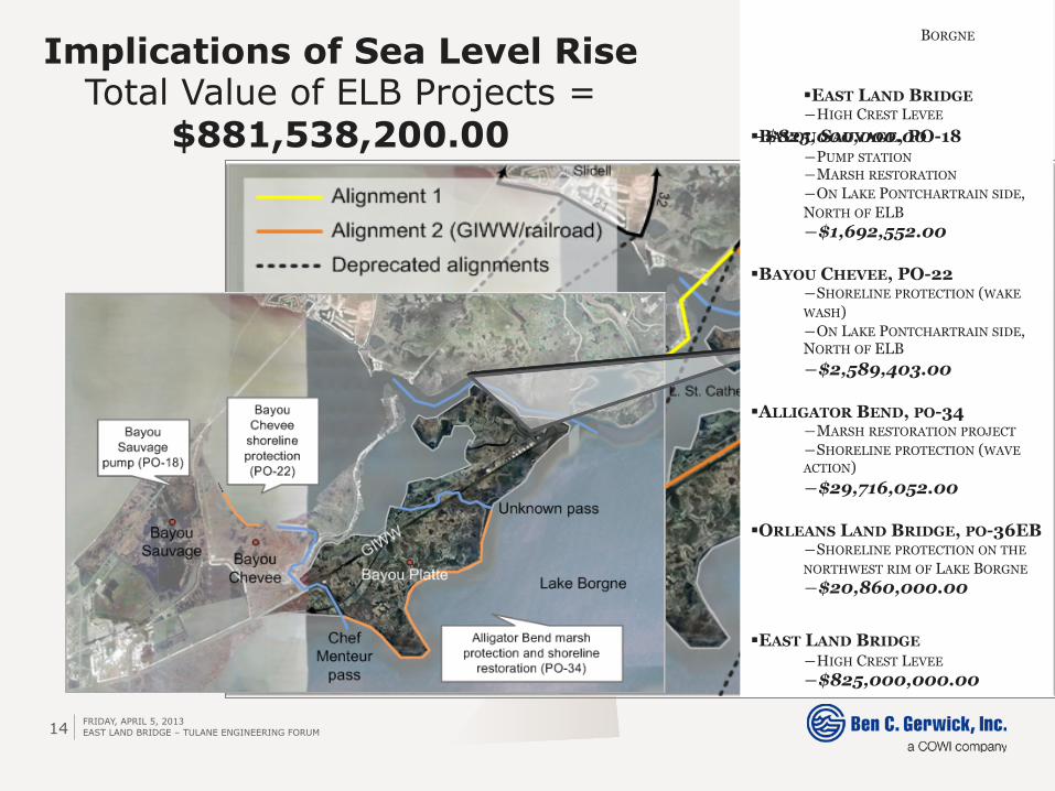
Implications of Sea Level Rise Total Value of ELB Projects =
$881,538,200.00
EAST LAND BRIDGE – TULANE ENGINEERING FORUM
BORGNE
§ EAST LAND BRIDGE ― HIGH CREST LEVEE
― $825,000,000.00 § BAYOU SAUVAGE, PO-18 ― PUMP STATION ― MARSH RESTORATION ― ON LAKE PONTCHARTRAIN SIDE, NORTH OF ELB ― $1,692,552.00
§ BAYOU CHEVEE, PO-22 ― SHORELINE PROTECTION (WAKE WASH) ― ON LAKE PONTCHARTRAIN SIDE, NORTH OF ELB ― $2,589,403.00
§ ALLIGATOR BEND, PO-34 ― MARSH RESTORATION PROJECT ― SHORELINE PROTECTION (WAVE ACTION) ― $29,716,052.00
§ ORLEANS LAND BRIDGE, PO-36EB ― SHORELINE PROTECTION ON THE NORTHWEST RIM OF LAKE BORGNE ― $20,860,000.00
§ EAST LAND BRIDGE
― HIGH CREST LEVEE ― $825,000,000.00
FRIDAY, APRIL 5, 2013 15
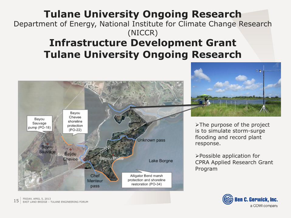
Tulane University Ongoing Research Department of Energy, National Institute for Climate Change Research
(NICCR) Infrastructure Development Grant
Tulane University Ongoing Research
EAST LAND BRIDGE – TULANE ENGINEERING FORUM
Ø The purpose of the project is to simulate storm-surge flooding and record plant response.
Ø Possible application for CPRA Applied Research Grant Program