Impact of Gold Mining on Water Quality in Bombana Regency ...
13
Impact of Gold Mining on Water Quality in Bombana Regency Southeast Sulawesi Province, Indonesia IRFAN IDO Department of Geography Faculty of Science and Technology of Earth Halu Oleo University Green Campus Bumi Tridharma Anduonohu H.E.A. Mokodompit Street INDONESIA [email protected] http://www.uho.ac.id SAWALUDIN Department of Geography Faculty of Science and Technology of Earth Halu Oleo University Green Campus Bumi Tridharma Anduonohu H.E.A. Mokodompit Street INDONESIA [email protected] http://www.uho.ac.id MUKHTAR Agribusiness Department of the Faculty of Agriculture Halu Oleo University Green Campus Bumi Tridharma Anduonohu H.E.A. Mokodompit Street INDONESIA [email protected] http://www.uho.ac.id and ASRUN LIO English Department of the Faculty of Education Halu Oleo University Green Campus Bumi Tridharma Anduonohu H.E.A. Mokodompit Street INDONESIA [email protected] http://www.uho.ac.id Abstract: - Bombana has the largest gold reserves amounted to 540 billion grams with an area of 205 400 ha reserve. This paper aims to identify the quality of river water and sea water as a result of gold mining in Bombana. The location of research in marine waters and rivers Bombana Southeast Sulawesi Province Indonesia specified purposive using the Global Positioning System (GPS), namely: (a) Locations in marine waters District of North Raowatu point coordinates: S. 04 0 38’ 51,77” E. 122 0 01’ 08,88”; b) marine waters Jaya subdistrict Lantari point coordinates: S. 04 0 37’ 26,04” E. 122 0 02’ 39,13”; (C) Langkowala River Jaya subdistrict Lantari the coordinates: S. 04 0 35’ 41”07 E. 121 0 59’ 33,22”, and (d) Rarowatu Tahi Ite River in the District of North Rarowatu the coordinates: S. 04 0 41’ 25,97” E. 121 0 49’06,00”. The parameters of water quality analysis used in the study are the parameters of physics, inorganic and organic chemistry as much as 24 (twenty-four) parameter. Test data analysis techniques used in the Laboratory of Environmental Chemistry Health Kendari Southeast Sulawesi province and compared with the standard quality of river water and sea. The conclusion of this paper are: (1) the status of river water quality in the category Kabuapten Bombana lightly polluted, where the concentration of Total Suspendid Solid (TSS), Biologycal Oxigen Demand Advances in Environmental and Geological Science and Engineering ISBN: 978-1-61804-314-6 444
Transcript of Impact of Gold Mining on Water Quality in Bombana Regency ...

Impact of Gold Mining on Water Quality in Bombana Regency Southeast Sulawesi Province, Indonesia
IRFAN IDO
Department of Geography Faculty of Science and Technology of Earth Halu Oleo University
Green Campus Bumi Tridharma Anduonohu H.E.A. Mokodompit Street INDONESIA
[email protected] http://www.uho.ac.id
SAWALUDIN Department of Geography Faculty of Science and Technology of Earth
Halu Oleo University Green Campus Bumi Tridharma Anduonohu H.E.A. Mokodompit Street
INDONESIA [email protected] http://www.uho.ac.id
MUKHTAR
Agribusiness Department of the Faculty of Agriculture Halu Oleo University
Green Campus Bumi Tridharma Anduonohu H.E.A. Mokodompit Street INDONESIA
[email protected] http://www.uho.ac.id
and
ASRUN LIO English Department of the Faculty of Education
Halu Oleo University Green Campus Bumi Tridharma Anduonohu H.E.A. Mokodompit Street
INDONESIA [email protected] http://www.uho.ac.id
Abstract: - Bombana has the largest gold reserves amounted to 540 billion grams with an area of 205 400 ha reserve. This paper aims to identify the quality of river water and sea water as a result of gold mining in Bombana. The location of research in marine waters and rivers Bombana Southeast Sulawesi Province Indonesia specified purposive using the Global Positioning System (GPS), namely: (a) Locations in marine waters District of North Raowatu point coordinates: S. 04038’ 51,77” E. 122001’ 08,88”; b) marine waters Jaya subdistrict Lantari point coordinates: S. 04037’ 26,04” E. 1220
02’ 39,13”; (C) Langkowala River Jaya subdistrict Lantari the coordinates: S. 04035’ 41”07 E. 1210
59’ 33,22”, and (d) Rarowatu Tahi Ite River in the District of North Rarowatu the coordinates: S. 04041’ 25,97” E. 1210 49’06,00”. The parameters of water quality analysis used in the study are the parameters of physics, inorganic and organic chemistry as much as 24 (twenty-four) parameter. Test data analysis techniques used in the Laboratory of Environmental Chemistry Health Kendari Southeast Sulawesi province and compared with the standard quality of river water and sea. The conclusion of this paper are: (1) the status of river water quality in the category Kabuapten Bombana lightly polluted, where the concentration of Total Suspendid Solid (TSS), Biologycal Oxigen Demand
Advances in Environmental and Geological Science and Engineering
ISBN: 978-1-61804-314-6 444
(BOD) in the water exceeded the quality standards based on existing regulations, and (2) Status water quality in the sea waters in the category of lightly polluted district, where Total Suspendid Solid (TSS, Nitrite (as NO2) and Mercury (hg) indicates exceeded water quality standards based on regulations'. Key-word: - The impact of gold mining, water quality, water quality status , Bombana Regency
1. Introduction
Natural resources is one of the authorized capital in the economic development of Indonesia, therefore, should be utilized as much as possible for the benefit of the people to pay attention to the preservation of life around. Important issues faced in economic development is how to deal with trade- offs between meeting the needs of development on one hand and efforts to maintain environmental sustainability on the other hand (Fauzi, 2007). Economic development based on natural resources that do not pay attention to aspects of environmental sustainability will ultimately have a negative impact on the environment itself. This is because the natural resources and the environment has a limited carrying capacity In other words, economic development does not pay attention to the capacity of natural resources and the environment will cause development problems in the future.
The environmental impact is defined as an environmental change caused by an and or activity. Impact as a change that occurs as a result of an activity where such activity may be natural, fine chemical, physical, and biological. The impact of business activities can be positive if perubahanyang resulting favorable and negative if the harm, pollute and damage the environment (Law of the Republic of Indonesia Number 32 of 2009 on the Protection and Management of the Environment).
One of the activities in exploiting natural resources are mining minerals, but mining activities in addition to the positive impact also can have negative impacts on the environment, especially the company, the landscape, the changing aesthetics of the environment, flora and fauna to be damaged, a loss of quality soil, water quality degradation or decrease in ground water level, the incidence of dust and noise. Fauzi (2010 ) states that the management of non -renewable resources (mining) often cause
problems of externalities. Externality that occurs is expected to start from the pre - construction stage, construction stage, the stage of mining operations, and post-mining phase .
Burke (2006 ) states that the characteristics of the mining activity in Asia is characterized by poor environmental management. MacMohan et.al. (2000) states that the environmental mitigation costs due to mining in Indonesia reached US $ 0.5 billion per year. The cost estimate has not entered a long-term negative impact of acid rock deposition on natural resources that are in the land and water. The phenomenon is reinforced by the opinions Fauzi (2014) which states that the costs of environmental degradation varies between US0,56 billion to US7,7 billion per year consisting of various types of degradation that air pollution, land degradation and water salinitasi.
Article 8 paragraph (1) of Government Regulation No. 82 of 2001 on water quality classification defined into four (4) classes: (a) First class, allocation of water can be used for the raw water of drinking water, and or other uses that require the same water quality with such purposes; (b). Class two, water allocation can be used for infrastructure/facilities water recreation, freshwater fish farming, animal husbandry, water to irrigate crops, and or other designation that requires the same water quality with the utility; (c). Third class, water allocation can be used for freshwater fish farming, animal husbandry, water to irrigate crops, and or other uses that require the same water with the utility; and (d). Fourth class, water allocation can be used to irrigate, crop and or other uses that require the same water quality with the usability.
The quality of surface water has become a very important issue in many countries, mainly due to fears that fresh water will become a scarce resource in the future so that the water
Advances in Environmental and Geological Science and Engineering
ISBN: 978-1-61804-314-6 445
quality monitoring program is needed for the protection of freshwater resources. Surface water quality is affected by anthropogenic and natural factors are complex. Anthropogenic sources of pollution that are not naturally arise because no influence or human intervention or human activities including mining activities. Anthropogenic activities significantly degrade the water quality of surface water systems in watersheds ( Pesce and Wunderlin, 2000; Zhao et.al, 2011; Wang et.al, 2007).
The function of the river is the river for the benefit of the presence of: (1). Human life , in the form of benefits where the river as a water provider and a container of water to meet the household needs, environmental sanitation, agriculture, industry, tourism, sports, defense, fisheries, power generation, transportation, and other needs; and (2). Natural life, in the form of benefits where the river as restoring water quality, flood dealer and main generating ecosystem of flora and fauna. Function as a restorer river water quality needs to be maintained by not burdening contaminants that exceed the ability of the natural recovery of the river (the Indonesian Government Regulation No. 38 Year 2011 on the River ) .
River plays a very important role in bringing municipal and industrial waste water and run-off of agricultural land and water bodies is one of the most susceptible to contamination (Singh et.al, 2004; Xiaoyun et.al, 2010). Common symptoms of environmental pollution caused by the mining industry waste that is immediately apparent is the change in the physical state as well as the designation of something environmental. River water or well water around the location of polluting industries, which was originally colored clear, changed into murky and foul-smelling frothy, so not worth used again by the residents around for bathing, washing, especially for raw materials drinking water. The river is a source of water for domestic, industrial and irrigation. On the health of residents of the surrounding communities can arise from a mild illness such as itching of the skin to severe form of genetic defects. The water quality of the river is one of the factors that are related to human health and
life. So it is very important to prevent and control pollution of the river (and Shang Yu, 2003; Santosa, RW, 2013: Kazi et.al, 2009).
Pollution in coastal areas may occur either naturally or due to human activities such as exploration-exploitation, industry, agriculture, and transportation. Various substances which enter into the marine environment can negatively impact the ecosystem biotic factors are changes in community structure, mass death, resistance to chemical substances by the organism and changes in the quality of the water productivity ( Chandra, 1988; Rompas, 1990).
Human activities in the utilization of mining resources that are not controlled can lead to disruption of coastal ecosystems, because wastes inorganic materials such as metals that are toxic from mining activities can flow to the sea through rivers
2. Problem Formulation Gold reserves are available in Southeast
Sulawesi Province of 1,125,000,000,000 grams. Gold reserves are spread in North Kolaka, Kolaka, Konawe, South Konawe and Bombana. Bombana is a region which has the largest gold reserves (540 billion) with total reserves of gold mining area of 205 400 ha. Location gold mine in Kabaputen Bombana found in areas Rarowatu toward Wumbubangka to the Settlement Unit II (Suseno, 2011).
Gold deposits in Bombana there are two types of primary-type epithermal gold deposits in rocks schist associated with cinnabar, secondary and alluvial gold deposits along streams as a result of rock debris found in the northern slopes of Mount Tangkeno Wumbubangka Raorawtu District of North and spread follow the flow of the rivers. Prospects types of alluvial gold deposits in this area can be utilized by the community through the mining process follows the flow of the people who spread the rivers Tahi Ite tipped in the hill area Tangkeno Wumbubangka. As for gold deposits alluvium on oxidized schist rock units can be utilized by medium scale mining process using mechanical tools, to always consider
Advances in Environmental and Geological Science and Engineering
ISBN: 978-1-61804-314-6 446

environmental sustainability (Kisman, 2011; Pujiastuti , 2009 ) .
Gold mine began exploited since the end of 2008 in the District of North Rarowatu, both by local people and companies. But in September 2009, people are forbidden to perform mining activities. Mining is only done by a company that has had a Mining Business License ( IUP ). Until the year 2013, there were sixteen companies have IUP in the District of North Rarowatu including five IUP Production. Until 2015 there were two companies that still carry out production activities, namely: PT. Panca Logam Makmur ( PLM ) and PT. Sultra Utama Nikel (SUN).
Morphological conditions in the watershed Tahi Ite generally an undulating plateau area with creeks steep V-shaped and flows throughout the year. Tahi Ite river itself flows towards the south. On this river lies mining sites are located at the upstream and Tahi Ite mine site located in downstream Tahi Ite (Hadi, 2009).
Water can be a source of harm if not in the guard , both in terms of benefits and security. For example, the contamination of water by chemical substances other than turning off the life that exists around also damage the environment ( Subagio, PJ, 1999).
Identification of river water quality and marine coastal been done as a result of gold mining in the gold mining areas in Indonesia. Identification of water quality due to gold mining Pongkor in Bogor showed a decrease in the quality of the environment caused by waste mercury high enough good in stream sediment, soil and water. Then, identification of water quality (sedimentation ocean) around the mouth of the river as a result of gold mining in Central Sulawesi Poboya shows the metal content of mercury in sediments around the mouth of the River Poboya still below the allowable threshold value.
Therefore, identification of river water quality and coastal seas caused by gold mining in Bombana needs to be done as the implementation of environmentally sustainable development. Formulation of the problem in this research is how the impact of gold mining
on water quality in rivers and coastal sea Bombana Southeast Sulawesi Province, Indonesia ?
3. Problem Solution 3.1. Methodology
The location of research in marine waters and rivers in Bombana Southeast Sulawesi province of Indonesia determined by purposive with consideration of geographically adjacent coastal ocean and river with Regional Business License (WIUP) Gold Mining PT. Panca Logam Makmur (PLM) and PT. Sultra Utama Nikel (SUN). Furthermore, the coordinates of the location of a more detailed study is determined using a Global Positioning System (GPS ) which is a location determination system based on satellite signals that will generate information in the form of coordinates, latitude and location in the map. The research location details are as follows: 1) The location at sea Coastal District of
North Raowatu with coordinates: S. 04038’ 51,77” E. 122001’ 08,88”
2) The location on the sea coast Jaya subdistrict Lantari with coordinates:: S. 04037’ 26,04” E. 1220 02’ 39,13”
3) The location on the river in the district Langkowala Lantari Jaya with the coordinates : S. 04035’ 41”07 E. 1210 59’ 33,22”
4) The location in the River Tahi Ite Rarowatu in the District of North Rarowatu with coordinates : S. 04041’ 25,97” E. 1210
49’06,00” Picture 1. Water sampling on river water and sea water.
The tools used in research in the field,
namely: kite flow, therommeter, pH indicators,
Advances in Environmental and Geological Science and Engineering
ISBN: 978-1-61804-314-6 447

soil tester, the pipe, filter, digital camera and GPS . The tools used in laboratory research are: AAS, multilevel filter and book identification (Dharma , 1988).
Types of data and data collection techniques in this study were: (a). Primary data is data samples of water taken directly on the sea coast and river area of research; (b). secondary data obtained through recording data sourced government agencies, mining companies and the study of literature (articles, books and journals).
The parameters of water quality analysis used in the study are the parameters of physics, anorganic and organic chemistry as much as 24 (twenty- four ) parameters (Table 1). Table 1 . Parameters Water Quality Analysis
Examination Parameter Unit Unit
A. Physics Color Scale TCU Turbidity NTU Total Suspendid Solid (TSS) Mg/l B. Inorganic Chemistry pH (Derajat Keasaman) - Biologycal Oxigen Demand (BOD) Mg/l Chemical Oxigen Demand (COD) Mg/l Disolved Oxygen (DO) Mg/l Nitrat (sebagai NO3) Mg/l Amonnia (NH3) Mg/l Iron (Fe) Mg/l Leadl (Pb) Mg/l Mercury (Hg) Mg/l Cloride (Cl) Mg/l Nitrit (sebagai NO2) Mg/l Hardness (CaCO3) Mg/l Chromium (Cr) Mg/l Calcium (Ca) Mg/l Sodium (Na) Mg/l Manganese (Mn) Mg/l Potassium (K) Mg/l Magnesium(Mg) Mg/l Zinc (Zn) Mg/l Nickel (Ni) Mg/l C. Organic Chemistry Oils and Fats Mg/l
Data analysis techniques used in this research is descriptive qualitative, where the data obtained from the field and the research literature systematically arranged, then performed a qualitative descriptive analysis. In a qualitative descriptive analysis attention sea and river water samples obtained from 4 (four) the coordinates of the location of the study were analyzed using a Chemical Test Environmental Health Laboratory Kendari in Southeast Sulawesi Province. Furthermore, compared with the data quality standards for river and sea water obtained from the research literature, namely: (1) of Government Regulation No. 82 of 2001 on water management and water pollution control; and ( 2 ) Southeast Sulawesi Regional Regulation No. 7 of 2005.
3.2. Water Quality Around Gold Mining Business Area Bombana
3.2.1. River Water Quality Gold mine site in Bombana is in Tahi Ite
river flow and river flow in the area of real Wuwubangka still comes from the same source of the river upstream to the River Tahi Ite. Langkowala river in Lantari Jaya has upstream on the River Tahi Ite. River water used in washing soil particles in the processing of gold either by the public or by private companies. Wastewater from the processing of gold is then discharged into the river. This condition occurs that encourage pollution in river water. Andri et al (2011 ) stated that environmental degradation will occur due to mining process is done in the river, as a result tailings waste into the river make the river murky and polluted. River pollution can also be sourced from waste people's daily activities of miners and workers of private companies.
Status of water quality in the river Tahi Ite North Rawowatu and river Langkowala Lantari Jaya in lightly polluted category. That is, the water quality of the river water became polluted and risky to be used for the fulfillment of human needs, such as for drinking, bathing, washing and so on as well as for the survival of various aquatic biota of the river. This phenomenon is based on the measurement
Advances in Environmental and Geological Science and Engineering
ISBN: 978-1-61804-314-6 448
results (appendix1) the concentration parameter physics, namely Total Suspendid Solid ( TSS ) at two locations stream with specification mode Gravimetry showed that the concentration of TSS and exceed water quality standards based on existing regulations (50 mg/l) and the concentration of inorganic chemistry parameters that Biologycal Oxigen Demand (BOD) with mode specifications BOD meter indicates exceeded water quality standards that have been established (3 mg/l).
TSS concentrations in river Langkowala Lantari Jaya subdistrict higher (457 mg/l) in comparing in a river Tahi Ite North Rarowatu (93 mg/l). That is silting and obstruction of sunlight into the bottom of the water so that the process can not take place photosynthetic microorganisms in river waters Langkowala Lantari Jaya is larger.
Changes in water quality in the two locations of the river is the continuing impact of erosion and sedimentation derived from the activities of clearing and stripping of overburden and mining. A decrease in water quality due to increased levels of TSS and minerals transported together soil particles that enter the waters within the study area. Typically such a change in the water caused by suspended materials and dissolved despite the normal conditions related material concentration is very low, so the changes are not visible or obtrusive
TSS is the sum of the weights of materials that are suspended in a certain volume of water. TSS variable generally consists of phytoplankton, zooplankton, human waste, animal manure, sludge, crop residues and animal and industrial waste. A logical consequence of the suspended solids is to reduce the self- purification and also cover the basic organisms inhabiting the bottom of a river ecosystem Langkowala in Lantari Jaya and Tahi Ite River in North Rarowatu.
The suspended substance typically consists of organic and inorganic substances floating in the water, in physics this substance as the cause of turbidity in the water. Liquid waste has a high content of suspended substances should not be discharged directly into water bodies as well as can cause silting also can block the
sunlight into the bottom of the water so that the process can not take place photosynthetic microorganisms (Anonymous, 2012 ) .
River water quality status in the category of lightly polluted sebakan also by the concentration of inorganic chemistry parameters that Biologycal Oxigen Demand (BOD) in the river with two locations BOD Meter mode specification indicates exceeded water quality standards that have been established (3 mg/l). BOD concentration in the river Langkowala Lantari Jaya (4.21 mg/l) higher than the river in North Rarowatu Tah Ite (3.55 mg/l).
Oxygen is needed by all living bodies to respiratory and metabolic processes. In the waters of oxygen plays a role in the process of oxidation reduction den chemicals into simpler compounds as nutrients that are needed aquatic organisms. The main source of oxygen in waters derived from free air diffusion process and the results of the process of photosynthesis. To determine the quality of a body of water the parameters of dissolved oxygen (DO) and biochemical oxygen demand (BOD) plays an important role. The principle of determination can be done by means of iodometric titration or directly by means of the DO meter. A lower pollution level waters and waters which could be categorized as good, the levels of dissolved oxygen (DO) > 5 ppm, and levels of biochemical oxygen (BOD) ranges from 0-10 ppm (Salmin, 2005).
Pollution caused by the TTS and BOD concentrations that exceed water quality standards in the river area of research, can also be caused by agricultural activities along the river who use fertilizers and pesticides. In case of rain, the flow of surface water (run off) containing chemical fertilizers and pesticides will flow into the river.
Status of water quality in the Tahi Ite river North Rawowatu and Langkowala river Lantari Jaya in the category of lightly polluted because of chemical parameters of organic and inorganic chemicals such as: Oils and Fats, pH (degree of acidity ), Disolved Oxygen (DO), Chemical Oxigen Demand (COD ), nitrate (as NO3), Chromium (Cr), zinc (Zn), lead (Pb), and
Advances in Environmental and Geological Science and Engineering
ISBN: 978-1-61804-314-6 449

mercury (Hg) is still in accordance with the magnitude of the value of river water quality standard based on Government Regulation No. 82 of 2001 on the Management and Control of water Quality and Pollution Control (appendix 1).
The concentration of inorganic chemistry parameters Mercury ( Hg ) or mercury is 0.0011 mg/l was found in the river water Langkowala Lantari Jaya subdistrict and 0.002 mg/l in water of the North Rarowatu Tahi Ite still in accordance with the quality standards (0.002 mg/l), That is , the content of heavy metal mercury is not harmful to the quality of the river water.
This is consistent with the results of research Trisnawaty, et.al. (2013) Levels of heavy metals in sediment Hg River Tahi Ite at each station showing still below the quality standards that ranged from 0.0001 to 0.0057 ppm, the heavy metal Hg in sediment was not too harmful for the environment. The low heavy metal Hg in sediment due to the use of heavy metals Hg on gold mining activities around the river flow Tahi Ite is rarely found and gold mining is already quite long lasting.
However, river water quality Tahi Ite North Rarowatu have a tendency contaminated by mercury concentration risk because it still allows an increase in concentration which could melamapui quality standards when gold mining using mercury do not environmentally friendly. Further prevention and control in order to prevent pollution of heavy metals, especially mercury higher because the heavy metal mercury is very harmful for human life and organisms and the environment. This is consistent with the statement, that the mercury (Hg) is listed as a pollutant which is very dangerous because of its toxicity can accumulate in the environment and can have an impact on living organisms. One solution is a gold processing business by using mercury should not throw waste (tailings) into the flow of the river so that no mercury contamination in the surrounding environment, and tailings containing mercury should be sited and handled carefully (Trisnawaty, et.al, 2013; Shreadah et al., 2012; Setiabudi, BT, 2005).
3.2.2. Marine Water Quality
The sea is a river estuaries various river channels. Thus the sea became a gathering contaminants brought water flow. Many industries or factories that dump untreated industrial waste or wastewater treatment beforehand and also the activities of households dispose of their waste into the river. These wastes are carried into the sea and further pollute the ocean (Yanney, 2001).
Tahi Ite river flow and river Langkowala in Bombana empties into the ocean waters and the District of North Rarowatu Lantari Jaya subdistrict. Thus, the pollution that occurs in river water due to leaching soil particles using river water in the processing of gold either by the public or by private companies and waste (tailings) waste into the river affects the pollution in coastal waters Bombana. Therefore, solving the problem of this research is directed to disclose facts that occur on water quality in marine waters both areas of research.
Status of water quality in marine waters and the District of North Rawowatu Lantari Jaya subdistrict in lightly polluted category. That is, the water quality of the river water became polluted and risky to be used for aquaculture activities and fishing for coastal communities and threaten the survival of the various marine biota. This phenomenon is based on the measurement results (appendix 2 the concentration of physical parameters, namely Total Suspendid Solid (TSS) at two locations marine waters with specification mode Gravimetry showed that the concentration of TSS and exceed water quality standards based on existing regulations (20 mg/l), concentration namely inorganic chemistry parameters Nitrite (as NO2) by spectrophotometric mode specification indicates exceeded water quality standards that have been established (1 mg/l), and the concentration of inorganic chemistry parameters namely Mercury (hg) with ASS mode specification indicates exceeded water quality standards which have been set ( 0.01 mg / l ).
TSS concentrations in marine waters Northern District of Rarowatu higher (371
Advances in Environmental and Geological Science and Engineering
ISBN: 978-1-61804-314-6 450
mg/l) in comparing in marine waters Lantari Jaya (132 mg/l). That is silting and obstruction of sunlight into the bottom of the water so that the process of photosynthesis microorganisms can not take place in the waters of the North Rarowatu greater. Pollution caused by waste from gold mining, farming and household activities that go into the waters of the river and carried away in the flow of the river to the mouth of the river area of research.
Concentration of Nitrite (as NO2) in marine waters Jaya subdistrict Lantari higher (6.02 mg/l) in comparing in marine waters of North Rarowatu (5.46 mg/l). That is, the level of pollution of marine waters as a result of higher nitrite content of marine waters Lantari Jaya. The content of nitrite are very harmful to human health (can suffer from cancer) when consuming fish and other biota sourced from the waters of the sea. According to the use of sodium nitrite in an amount that exceeds the limit turned out to cause harmful effects on health, as nitrites can bind with the amino and amide contained in meat protein forming derivatives that are toxic nitrosoamin. Nitrosoamin is a compound suspected to cause cancer (Doul , 1986; Winarno, 1984) .
One source of mercury pollution that occurred came from gold penambangnan done by the community with the processing of gold through amalgamation. In the process, the mercury can be released into the environment at the stage of leaching. In the washing process, the waste is generally still contain mercury discharged directly into water bodies. This is due to mercury is mixed/split into fine granules that are difficult to separate the milling process is carried out simultaneously with the process of leaching of mercury in the waste washed into the river. Besides, mercury pollution can also be derived from the disposal of solid waste (tailings) without first processing (Denny 2005 in Purnawan, et.al, 2013).
The concentration of inorganic chemistry parameters Mercury (Hg) or mercury is 0.0557 mg/l was found in marine waters Lantari Jaya subdistrict and 0.624 mg/l was found in the sea waters of the North Rarowatu exceeded the threshold quality standards (0.001 mg/l). This condition is very risky both for the life of aquatic animals in those waters for human
health and aquatic animals that consume marine research area.
Mercury (Hg) contained in the effluent (waste) in public waters is converted by the activity of microorganisms into the components methyl-mercury (Me-Hg ) which has toxic properties and strong holding capacity in addition to its high solubility , especially in the animal body of water. This resulted in mercury accumulated through the process of bioaccumulation and biomagnification is through the food chain (food chain ) in the body tissues of the body of water animals, so that the levels of mercury can reach levels hazardous to life or human health of aquatic animals that consume the catch animals- the aquatic animals (Harizal, 2006).
Status of water quality in marine waters of the North and Lantari Rawowatu Jaya in the category of lightly polluted because inorganic chemical parameters such as pH (degree of acidity), Chloride (Cl), iron (Fe), zinc (Zn). Nickel (Ni), and lead (Pb), the amount of value still in accordance with the sea water quality standard based on Southeast Sulawesi Regional Regulation No. 7 of 2005 (Appendix 2).
Characteristics of the mining business and the potential impact it may cause environmental pencaraman one of which is the deterioration of water quality in rivers and marine waters, then in practice the mining business activities require environmental management efforts as early as possible both during the pre- mining, mining and post- mining.
In principle, mines should be directed at environmentally sound management towards sustainable development that contribute to human welfare poisitif between generations in the dimensions of environmental, social and economic. As noted Otto and Cordes (2002) that social revolution is a real - life environment has changed how approaches undertaken international mining industry in conducting its business activities. Fauzi (2010) says implicitly that the concept of concern are: (1) regarding the importance of considering the natural resources and environmental constraints on development and consumption patterns; and (2)
Advances in Environmental and Geological Science and Engineering
ISBN: 978-1-61804-314-6 451
concerning attention to the welfare of future generations.
4. Conclusion
Based on the results of the study, formulated the following conclusions : 1) Status of river water quality in Bombana in
the lightly polluted category, in which the concentration of Total Suspendid Solid (TSS), Biologycal Oxigen Demand (BOD) exceeded water quality standards based on existing regulations.
2) Status of marine water quality in Bombana in the lightly polluted category, which the concentration of Total Suspendid Solid (TSS), Nitrite (as NO2) and Mercury (hg) indicates exceeded water quality standards based on existing regulations.
References:
[1] Andri D.H., Anies., H, Suharyo, 201!. Levels of Mercury in Hair People Around Gold Mining Without Permission. Diponegoro University School of Medicine and the Indonesian Doctors Association of Central Java. Semarang. 45 ( 3 ) : 181-187
[2] Anonymous, 2012, Wastewater Quality Indicators. http : //inspeksisanitasi.blogspot.com/2012/01/indikator-kualitas-air-limbah.html . downloaded from the Internet on June 4, 2015 at 20:15 pm .
[3] Burke, G. 2006. Opportunities for Environmental Mnagement in The Mining Sector in Asia (abstract). The Journal of Environment & Development 15 (2): 224 – 235.
[4] Candra, S, 1988. Heavy Metal Monitoring and Toxity in India. Manual on Aquatic Ecotoxilogy. H. de Krurjf. D. Dezwart, P. Viswanathan and P. Ray Eds. Allied Publishers, Ltd. India
[5] Doul J., C.D. Klassen and M.O. Amdur,
(1986), Chemistry Carsinogen in Casarett and Doull’s, Hanbook of Toxicology The Basic Science of Poisons, 2nd
Ed., Mac Millan Publishing Co., New York.
[6] Fauzi, A. 2007. Economic Natures 's Non-Convexity. Reorentasi Economic Development of Natural Resources and Implications for Indonesia. Scientific Oration. Faculty of Economics and Management, Bogor Agricultural University, Bogor
[7] Fauzi A. 2010. Environmental and
Natural Resource Economics. Theory and Applications. Indonesia, Jakarta.: PT. Gramedia Utama Pustaka.
[8] Fauzi A. 2014. Economic Valuation and
Natural Resources Damage Assessment and Environmental. IPB Press, Bogor.
[9] Hadi I.S. 2009. Put Gold of Mining by
Bombana Community and Its Effect on the Environment
[10] Harizal. 2006. Study of Heavy Metal
Concentrations of Mercury (Hg) At Green Mussels (Perna Viridis l) as Bio Monitoring of Pollution in Coastal Waters Edge Pangkah Banyu Urip District of Gresik, East Java. Thesis report , Management of Water Resources UB . Malang .
[11] Kazi, T. G., M. B. Arain., M. K. Jamali.,
N. Jalbani., H. I. Afridi., R. A. Sarfraz., J. A. Baig., A. Q. Shah. 2009. Assessment of water quality of polluted lake using multivariate statistical techniques: A case study. Ecotoxicology and Environmental Safety, 72(2): 301-309.
[12] Kisman, 2011. Gold mineralization
occurrences associated with cinnabar In District Rarowatu Bombana Southeast
Advances in Environmental and Geological Science and Engineering
ISBN: 978-1-61804-314-6 452
Sulawesi Province . Geological Resources Bulletin Volume 6 Number - 2011 page 23
[13] Law of the Republic of Indonesia Number 32 of 2009 about Protection and Management of the Environment
[14] Indonesian Government Regulation No.
82 of 2001 on Water Management and Water Pollution Control
[15] Mc Mahon, G., E.R.Subdibjo, J. Aden, A.Bouzaher, G.Dore, and R.Kunanayagam. 2000. Mining and the Environment in Indonesia: Long-term Trends and Repercussions of the Asian Economic Crisis. Environment and Social Development Unit (EASES), East Asia and Pacific Region of the World Bank. Washington, DC.
[16] Otto, J. and Cordes, J. 2002. The
Regulation of Mineral Enterprises: A Global Perspective on Economics, Law and Policy. Westminster, USA: Rocky Mountain Mineral Law Foundation
[17] Pesce, S. F. and Wunderlin, D. A. 2000.
Use of water quality indices to verify the impact of Córdoba city (Argentina) on Suquía River. Water Research, 34: 2915-2926.
[18] Rompas, R. M, 1990. Assessing
Pollutants Levels of Mercury in Aquatic Bolaan Mangondouw Gold mining activities result. Research Report. Agricultural Development Board> DEPTAN.
[19] Salmin, 2005. “Oseana” Dissolved
Oxygen (DO) and Biological oxygen demand (BOD) as One indicator Determine Water Quality. Volume XXX, No. 3, pp : 21-26
[20] Subagio, P.J., 1999. Environmental Law,
Problems and Penanggulangnya. New
Edition Prints both. Rhineka Cipta. Jakarta. page 3
[21] Pudjiastuti. 2009. Gold Mining Activity
Impact on Economic Social and Cultural Society in Bombana. Competitive programs LIPI, Jakarta.
[22] Purnawan, S., Sikkana, R.,
Prismawiryanti, 2013. Mercury Metals Distribution At Sea Sediment Around estuary Poboya. Online Jurnal of Natural Science, Vol. 2 (1): 18-24 ISSN: 2338-0950 Maret 2013.
[23] Santosa, R.W, 2013, Impact of
Environmental Pollution By Sea Traditional Fishermen Against Mining Company. Lex Administratum, Vol.I/No.2/Apr-Jun/2013.
[24] Setiabudi, B.T., 2005. Due to the spread
of Mercury Gold Mining Business in the Region Sangon, Kulon Progo, Yogyakarta . Colloquium Results Field.
[25] Singh, K. P., A. Malik., D. Mohan, and S.
Sinha. 2004. Multivariate Statistical Techniques for the Evaluation of Spatial and Temporal Variations in Water Quality of Gomti River (India)—a Case Study. Water Research, 38(18): 3980-3992.
[26] Shreadah, M. A., S. A. A. Ghani., A. A.
E. S. Taha., A. E. M. M.Ahmed., H. B. I. Hawash. 2012. Journal of Environmental Protection Mercury and Methyl Mercury in Sediments of Northern Lakes-Egypt. National Institute of Oceanography and Fisheries. Department, Faculty of Science. Alexandria University. Alexandria. 3: 254-261.
[27] Southeast Sulawesi Provincial Regulation
No. 7 of 2005 [28] Suseno, T., 2011. Analysis of Regional
Economic Development of Southeast
Advances in Environmental and Geological Science and Engineering
ISBN: 978-1-61804-314-6 453
Sulawesi Province Based Mining Sector. Research Report Research And Development Center Technology Mineral and Coal, Ministry of Energy and Mineral Resources
[29] Trisnawaty, F,N., Emiyarti, Afu L.A,, 2013.
Relation of Heavy Metal Levels of Mercury (Hg) in Sediments with Community Structure of Makrozoobenthos in Tahi Ite River, Rarowatu District of Bombana. Jurnal Mina Laut Indonesia Vol. 03 No. 12 Sep 2013 (68– 80) ISSN : 2303-3959
[30] Law of the Republic of Indonesia Number
32 of 2009 on the Protection and Management of the Environment
[31] Wang, X., Y.L. Yong., H. Jing-yi., H.
Gui-zhen., W. Tie-yu. 2007. Identification of Anthropogenic Influences on Water Quality of Rivers in Taihu Watershed. Journal of Environmental Management. 19: 475-481.
[32] Winarno, F.G., (1984), Chemistry of Food
And Nutrition. Gramedia Pustaka Utama. [33] Xiaoyun, F., B. Cui., H. Zhao., Z.
Zhiming.,Z. Honggang. 2010. Assessment of river water quality in Pearl River Delta using multivariate statistical techniques. Procedia Environmental Sciences, 2:1220-1234.
[34] Yanney, 2001. Tropical Ecology.
Bandung Institute Of Technology. Bandung.
[35] Yu, S and J. Shang. 2003. Factor analysis
and dynamics of water quality of the Songhua River, Northeast China. Water Air Soil Pollution Journal, 144: 159-169.
[36] Zao, J., G. Fu., K. Lei., Y. Li. 2011.
Multivariate Analysis of Surface Water Quality in the There Gorges Area of China and Implications for Water
Management. Journal of Environmental Sciences. 23 (9): 1460-1471
Advances in Environmental and Geological Science and Engineering
ISBN: 978-1-61804-314-6 454

App
endi
x 1.
The
resu
lts o
f wat
er q
ualit
y an
alys
is in
the
AS-
003
Loc
atio
n (L
angk
owal
a R
iver
Wat
er L
anta
ri Ja
ya L
ocat
ion/
Coo
rdin
ates
: S.
04 o 35
' 41
" E
. 121
0 07
59'
33.
22 "
) an
d Lo
catio
n A
S- 0
04 (R
iver
Tah
i Ite
Rar
owat
u lo
catio
n/co
ordi
nate
: S. 0
40 41’ 2
5,97
” E.
12
10 49
’06,
00”)
by
Riv
er W
ater
Qua
lity
Stan
dard
s ac
cord
ing
to t
he I
ndon
esia
n G
over
nmen
t R
egul
atio
n N
o. 8
2 of
200
1 on
W
ater
Man
agem
ent a
nd W
ater
Pol
lutio
n C
ontro
l
No
Exa
min
atio
n Pa
ram
eter
Uni
t U
nit
Che
ck U
p R
esul
t Sp
ecifi
catio
ns M
ode
Qua
lity
Stan
dard
s A
S-00
3 A
S-00
4 II
II
I IV
A
Ph
ysic
s
1 C
olor
Sc
ale
TCU
10
50
vi
sual
com
paris
on
- -
- 2
Turb
idity
N
TU
4,10
51
3 N
ephe
lom
etrik
-
- -
3 To
tal S
uspe
ndid
Sol
id (T
SS)
Mg/
l 93
45
7 G
ravi
met
ri 50
40
0 40
0 B
In
orga
nic
Che
mis
try
4
pH (D
eraj
at K
easa
man
) -
6,62
8,
51
SNI 0
6-69
89.1
1-20
04
6-9
6-9
6-9
5 Bi
olog
ycal
Oxi
gen
Dem
and
(BO
D)
Mg/
l 4,
21
3,55
B
OD
Met
er
3 6
12
6 C
hem
ical
Oxi
gen
Dem
and
(CO
D)
Mg/
l 10
15
Ti
trim
etri
25
50
100
7 D
isol
ved
Oxy
gen
(DO
) M
g/l
3,42
2,
39
DO
Met
er
4 3
0 8
Nitr
at (s
ebag
ai N
O3)
Mg/
l 3,
20
3,15
Sp
ektro
foto
met
rik
10
20
20
9 Am
onni
a (N
H3)
M
g/l
< 0,
01
< 0,
01
Spek
trofo
tom
etrik
-
- -
10
Iron
(Fe)
M
g/l
0,06
0,
10
Spek
trofo
tom
etrik
-
- -
11
Lead
l (Pb
) M
g/l
0,00
14
0,00
33
ASS
0,
03
0,03
1
12
Mer
cury
(Hg)
M
g/l
0,00
11
0,00
20
ASS
0,
002
0,00
2 0,
005
13
Clo
ride
(Cl)
Mg/
l 28
,8
17,5
1 Ti
trim
etri
- -
- 14
N
itrit
(seb
agai
NO
2) M
g/l
< 0,
02
0,10
Sp
ektro
foto
met
rik
0.06
0.
06
- 15
H
ardn
ess
(CaC
O3)
Mg/
l 24
4 13
2,6
Titri
met
ri -
- -
16
Chr
omiu
m (C
r)
Mg/
l 0,
0102
0,
0122
A
SS
0,05
0,
5 -
17
Cal
cium
(Ca)
M
g/l
30,1
33
,4
ASS
-
- -
18
Sodi
um (N
a)
Mg/
l 0,
2551
0,
1447
A
SS
- -
- 19
M
anga
nese
(Mn)
M
g/l
0,05
21
0,16
80
ASS
-
- -
20.
Pota
ssiu
m (K
) M
g/l
58,5
0,
0699
A
SS
- -
- 21
M
agne
sium
(Mg)
M
g/l
58,5
31
,2
ASS
-
- -
22
Zinc
(Zn)
M
g/l
0,02
24
0,03
87
ASS
0,
05
0,05
2
23
Nic
kel (
Ni)
Mg/
l 0,
0188
0,
0203
A
SS
- -
- C
O
rgan
ic C
hem
istr
y
24
Oils
and
Fat
s M
g/l
0,4
0,6
Gra
vim
etri
1 1
-
Advances in Environmental and Geological Science and Engineering
ISBN: 978-1-61804-314-6 455
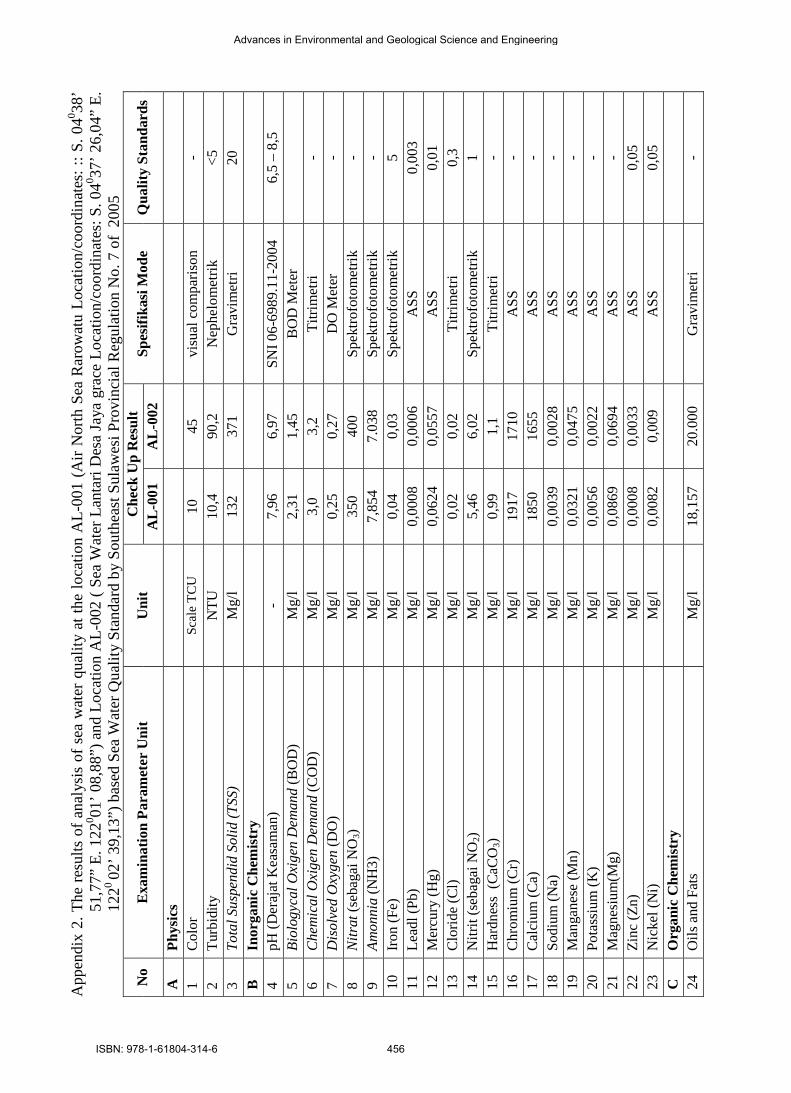
App
endi
x 2.
The
resu
lts o
f ana
lysi
s of
sea
wat
er q
ualit
y at
the
loca
tion
AL-
001
(Air
Nor
th S
ea R
arow
atu
Loca
tion/
coor
dina
tes:
:: S
. 040 38
’ 51
,77”
E. 1
220 01
’ 08,
88”)
and
Loc
atio
n A
L-00
2 ( S
ea W
ater
Lan
tari
Des
a Ja
ya g
race
Loc
atio
n/co
ordi
nate
s: S
. 040 37
’ 26,
04”
E.
1220
02’ 3
9,13
”) b
ased
Sea
Wat
er Q
ualit
y St
anda
rd b
y So
uthe
ast S
ulaw
esi P
rovi
ncia
l Reg
ulat
ion
No.
7 o
f 20
05
No
Exa
min
atio
n Pa
ram
eter
Uni
t U
nit
Che
ck U
p R
esul
t Sp
esifi
kasi
Mod
e Q
ualit
y St
anda
rds
AL
-001
A
L-0
02
A
Phys
ics
1
Col
or
Scal
e TC
U
10
45
visu
al c
ompa
rison
-
2 Tu
rbid
ity
NTU
10
,4
90,2
N
ephe
lom
etrik
<5
3
Tota
l Sus
pend
id S
olid
(TSS
) M
g/l
132
371
Gra
vim
etri
20
B
Inor
gani
c C
hem
istr
y
4 pH
(Der
ajat
Kea
sam
an)
- 7,
96
6,97
SN
I 06-
6989
.11-
2004
6,
5 –
8,5
5 Bi
olog
ycal
Oxi
gen
Dem
and
(BO
D)
Mg/
l 2,
31
1,45
B
OD
Met
er
6
Che
mic
al O
xige
n D
eman
d (C
OD
) M
g/l
3,0
3,2
Titri
met
ri -
7 D
isol
ved
Oxy
gen
(DO
) M
g/l
0,25
0,
27
DO
Met
er
- 8
Nitr
at (s
ebag
ai N
O3)
Mg/
l 35
0 40
0 Sp
ektro
foto
met
rik
- 9
Amon
nia
(NH
3)
Mg/
l 7,
854
7.03
8 Sp
ektro
foto
met
rik
- 10
Iro
n (F
e)
Mg/
l 0,
04
0,03
Sp
ektro
foto
met
rik
5 11
Le
adl (
Pb)
Mg/
l 0,
0008
0,
0006
A
SS
0,00
3 12
M
ercu
ry (H
g)
Mg/
l 0,
0624
0,
0557
A
SS
0,01
13
C
lorid
e (C
l) M
g/l
0,02
0,
02
Titri
met
ri 0,
3 14
N
itrit
(seb
agai
NO
2) M
g/l
5,46
6,
02
Spek
trofo
tom
etrik
1
15
Har
dnes
s (C
aCO
3) M
g/l
0,99
1,
1 Ti
trim
etri
- 16
C
hrom
ium
(Cr)
M
g/l
1917
17
10
ASS
-
17
Cal
cium
(Ca)
M
g/l
1850
16
55
ASS
-
18
Sodi
um (N
a)
Mg/
l 0,
0039
0,
0028
A
SS
- 19
M
anga
nese
(Mn)
M
g/l
0,03
21
0,04
75
ASS
-
20
Pota
ssiu
m (K
) M
g/l
0,00
56
0,00
22
ASS
-
21
Mag
nesi
um(M
g)
Mg/
l 0,
0869
0,
0694
A
SS
- 22
Zi
nc (Z
n)
Mg/
l 0,
0008
0,
0033
A
SS
0,05
23
N
icke
l (N
i) M
g/l
0,00
82
0,00
9 A
SS
0,05
C
O
rgan
ic C
hem
istr
y
24
Oils
and
Fat
s M
g/l
18,1
57
20.0
00
Gra
vim
etri
-
Advances in Environmental and Geological Science and Engineering
ISBN: 978-1-61804-314-6 456