How Norfolk Coast Cycleway Explorers Coast Cycleway Explorers Loops off the Norfolk Coast Cycleway...
2
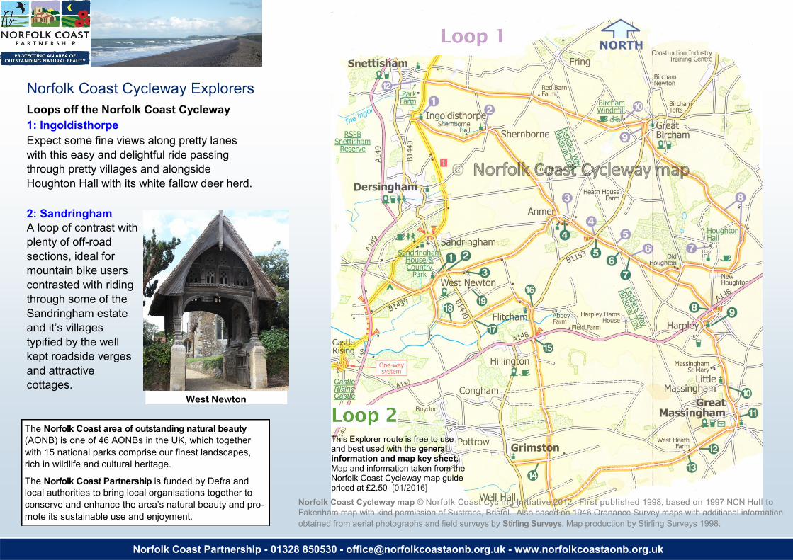
Norfolk Coast Partnership - 01328 850530 - [email protected] - www.norfolkcoastaonb.org.uk Norfolk Coast Cycleway Explorers Loops off the Norfolk Coast Cycleway 1: Ingoldisthorpe Expect some fine views along pretty lanes with this easy and delightful ride passing through pretty villages and alongside Houghton Hall with its white fallow deer herd. 2: Sandringham A loop of contrast with plenty of off-road sections, ideal for mountain bike users contrasted with riding through some of the Sandringham estate and it’s villages typified by the well kept roadside verges and attractive cottages. . How The Norfolk Coast area of outstanding natural beauty (AONB) is one of 46 AONBs in the UK, which together with 15 national parks comprise our finest landscapes, rich in wildlife and cultural heritage. The Norfolk Coast Partnership is funded by Defra and local authorities to bring local organisations together to conserve and enhance the area’s natural beauty and pro- mote its sustainable use and enjoyment. West Newton 11 Norfolk Coast Cycleway map © Norfolk Coast Cycling Initiative 2012. First published 1998, based on 1997 NCN Hull to Fakenham map with kind permission of Sustrans, Bristol. Also based on 1946 Ordnance Survey maps with additional information obtained from aerial photographs and field surveys by Stirling Surveys. Map production by Stirling Surveys 1998. This Explorer route is free to use and best used with the general information and map key sheet. Map and information taken from the Norfolk Coast Cycleway map guide priced at £2.50 [01/2016]
Transcript of How Norfolk Coast Cycleway Explorers Coast Cycleway Explorers Loops off the Norfolk Coast Cycleway...
Norfolk Coast Partnership - 01328 850530 - [email protected] - www.norfolkcoastaonb.org.uk
Norfolk Coast Cycleway Explorers
Loops off the Norfolk Coast Cycleway
1: Ingoldisthorpe
Expect some fine views along pretty lanes
with this easy and delightful ride passing
through pretty villages and alongside
Houghton Hall with its white fallow deer herd.
2: Sandringham
A loop of contrast with
plenty of off-road
sections, ideal for
mountain bike users
contrasted with riding
through some of the
Sandringham estate
and it’s villages
typified by the well
kept roadside verges
and attractive
cottages.
.
How
The Norfolk Coast area of outstanding natural beauty
(AONB) is one of 46 AONBs in the UK, which together
with 15 national parks comprise our finest landscapes,
rich in wildlife and cultural heritage.
The Norfolk Coast Partnership is funded by Defra and
local authorities to bring local organisations together to
conserve and enhance the area’s natural beauty and pro-
mote its sustainable use and enjoyment.
West Newton
11
Norfolk Coast Cycleway map © Norfolk Coast Cycling Initiative 2012. First published 1998, based on 1997 NCN Hull to
Fakenham map with kind permission of Sustrans, Bristol. Also based on 1946 Ordnance Survey maps with additional information
obtained from aerial photographs and field surveys by Stirling Surveys. Map production by Stirling Surveys 1998.
This Explorer route is free to use and best used with the general information and map key sheet. Map and information taken from the Norfolk Coast Cycleway map guide priced at £2.50 [01/2016]
This cycleway explorer is from the Norfolk Coast Cycleway map guide — www.norfolkcoastaonb.org.uk/cycling
Ingoldisthorpe Explorer (18 miles)
(1) The Church of St Michael and All Angels at
Ingoldisthorpe is said to have been built
deliberately lopsided, as only God is perfect!
Next is the small attractive village of Shernborne
(2) on the Sandringham estate as is Anmer, its
Church dedicated to St Mary (3).
Take care crossing the (B1153) Great Bircham to
Flitcham road (4) on the way to Houghton. (5)
Peddars Way National Trail (see box below), and
the Tumuli (6) (ancient burial mounds) should also
be visible along this section of road.
Follow the map and signs for Houghton Hall,
which is open to the public during the summer and
near the entrance (7) is the church is St Martins.
As you cycle alongside Houghton Hall park (8)
watch out for the striking white fallow deer.
At Great Bircham (9) the Kings Head and
Bircham Windmill (seasonal opening) (10) offer
refreshments. Continuing on towards Snettisham
crossing the Peddars Way again before com-
pleting the loop near Snettisham Park Farm (12).
along a heathland track (from east joins just after
West Heath Farm (13) After some distance turning
right at a T-junction onto woodland and farm
tracks, continue until emerging at A148 crossing at
Hillington (15). (14) Grimston option.
(16) Flitcham - 'Felix’s Ham' after Saint Felix who
was in residence after arriving from France in
AD630. Bear left in village and left towards B1440
(17), cross main road onto good surface track (18)
(signed Unsuitable for Motor Vehicles) before
joining West Newton road into the village to
complete the loop. (19) Remains of Appleton
Church.
Additional information
Cycle hire nearby:
Heacham; A E Wallis, Station Road
01485 571683 www.aewallis.co.uk
Public Transport: Traveline East Anglia 0871 200 2233
www.travelineeastanglia.org.uk
Rail Station: King’s Lynn 0345 026 4700 www.thameslinkrailway.com
Visitor information:
West Norfolk — www.visitwestnorfolk.com Tourist Information Centres at King’s Lynn 01553
763044 and Hunstanton 01485 532610.
Sandringham www.sandringhamestate.co.uk;
Houghton Hall www.houhgtonhall.com
Bircham Windmill www.birchamwindmill.co.uk
Snettisham Park www.snettishampark.co.uk
DISCLAIMER: Every effort has been made to ensure that the information contained here is accurate. The Norfolk Coast Partnership does not accept responsibility or liability for any errors or omissions, or their consequences.
Sandringham Explorer (22 miles)
The Norfolk Coast Cycleway passes through the
Sandringham Estate, this explorer commences
near the Camping & Caravan site at Double
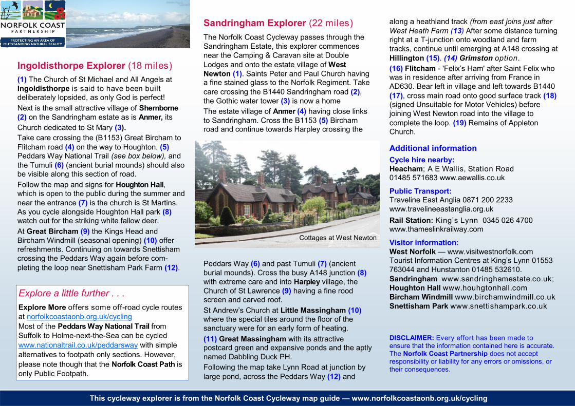
Lodges and onto the estate village of West
Newton (1). Saints Peter and Paul Church having a fine stained glass to the Norfolk Regiment. Take
care crossing the B1440 Sandringham road (2),
the Gothic water tower (3) is now a home
The estate village of Anmer (4) having close links
to Sandringham. Cross the B1153 (5) Bircham road and continue towards Harpley crossing the
Peddars Way (6) and past Tumuli (7) (ancient
burial mounds). Cross the busy A148 junction (8)
with extreme care and into Harpley village, the
Church of St Lawrence (9) having a fine rood
screen and carved roof.
St Andrew’s Church at Little Massingham (10)
where the special tiles around the floor of the
sanctuary were for an early form of heating.
(11) Great Massingham with its attractive postcard green and expansive ponds and the aptly
named Dabbling Duck PH.
Following the map take Lynn Road at junction by
large pond, across the Peddars Way (12) and
Explore a little further . . .
Explore More offers some off-road cycle routes
at norfolkcoastaonb.org.uk/cycling
Most of the Peddars Way National Trail from
Suffolk to Holme-next-the-Sea can be cycled
www.nationaltrail.co.uk/peddarsway with simple
alternatives to footpath only sections. However,
please note though that the Norfolk Coast Path is
only Public Footpath.
Cottages at West Newton