Geomorphological analysis of the morphometric characteristics that determine the volume of sediment...
18
J. Geogr. Sci. 2014, 24(3): 457-474 DOI: 10.1007/s11442-014-1100-8 © 2014 Science Press Springer-Verlag Received: 2013-03-25 Accepted: 2013-09-26 Author: Ali Hamdi Abu Salim, PhD, E-mail: [email protected] www.geogsci.com www.springerlink.com/content/1009-637x Geomorphological analysis of the morphometric characteristics that determine the volume of sediment yield of Wadi Al-Arja, South Jordan Ali Hamdi ABU SALIM Geography, AL-Hussein Bin Talal University, Ma’an, Jordan Abstract: This study addresses the morphometric variables that determine the sediment yield in Wadi Al-Arja through the analysis of the impact of different morphometric characteristics along the course of the valley on its sediment yield, as well as the analysis of spatial and formal dimensions and morphologies of the basin and its relationship to the sediment yield. The study also addresses the size of variation in the volume of sediment yield of the river tributaries that make up the water network of the valley under the differences of its mor- phometric and hydrological characteristics. The study found several results, most notably: The classification of Wadi Al-Arja basin according to the hypsometric integral value (72.1%) within an uneven topography, which in- creases the force of the erosive activity and the size of the sediment yield if the basin was exposed to moist climatic periods. The study also showed the presence of convergence in the intra-spaces between the river tributaries in the water network. This increases the volume of water flows when these tributaries meet with each other and thus increasing their erosive ability and sediment yield. The study also showed the presence of marked variation in the sediment yield of the river tributaries depending on the differences in its morphometric characteristics. The results of the step-wise regression analysis confirmed the importance of the morphometric and hydrological variables, and plant coverage in interpreting the variation in the size of the sediment yield of the river tributaries of different stream order in Wadi Al-Arja basin, where these variables interpreted 43% of the total variation, with statistical significance less than 0.05. Keywords: sediment yield; Wadi Al-Arja; morphometric characteristics: hypsometric integral; Jordan 1 Introduction The researchers’ concerns in the fields of geomorphological sciences and physical geogra- phy when they studied and dealt with the sedimentary yield in river basins were limited to the analysis of the role of the water erosive forces in determining the size and increase of the sedimentary yield, in view of the physical data enjoyed by river basins; among these physi- cal characteristics, the most notable were: climate, soil characteristics, vegetation, magni-
Transcript of Geomorphological analysis of the morphometric characteristics that determine the volume of sediment...
J. Geogr. Sci. 2014, 24(3): 457-474
DOI: 10.1007/s11442-014-1100-8
© 2014 Science Press Springer-Verlag
Received: 2013-03-25 Accepted: 2013-09-26 Author: Ali Hamdi Abu Salim, PhD, E-mail: [email protected]
www.geogsci.com www.springerlink.com/content/1009-637x
Geomorphological analysis of the morphometric characteristics that determine the volume of sediment yield of Wadi Al-Arja, South Jordan
Ali Hamdi ABU SALIM
Geography, AL-Hussein Bin Talal University, Ma’an, Jordan
Abstract: This study addresses the morphometric variables that determine the sediment yield in Wadi Al-Arja through the analysis of the impact of different morphometric characteristics along the course of the valley on its sediment yield, as well as the analysis of spatial and formal dimensions and morphologies of the basin and its relationship to the sediment yield. The study also addresses the size of variation in the volume of sediment yield of the river tributaries that make up the water network of the valley under the differences of its mor-phometric and hydrological characteristics.
The study found several results, most notably: The classification of Wadi Al-Arja basin according to the hypsometric integral value (72.1%) within an uneven topography, which in-creases the force of the erosive activity and the size of the sediment yield if the basin was exposed to moist climatic periods. The study also showed the presence of convergence in the intra-spaces between the river tributaries in the water network. This increases the volume of water flows when these tributaries meet with each other and thus increasing their erosive ability and sediment yield.
The study also showed the presence of marked variation in the sediment yield of the river tributaries depending on the differences in its morphometric characteristics. The results of the step-wise regression analysis confirmed the importance of the morphometric and hydrological variables, and plant coverage in interpreting the variation in the size of the sediment yield of the river tributaries of different stream order in Wadi Al-Arja basin, where these variables interpreted 43% of the total variation, with statistical significance less than 0.05.
Keywords: sediment yield; Wadi Al-Arja; morphometric characteristics: hypsometric integral; Jordan
1 Introduction
The researchers’ concerns in the fields of geomorphological sciences and physical geogra-phy when they studied and dealt with the sedimentary yield in river basins were limited to the analysis of the role of the water erosive forces in determining the size and increase of the sedimentary yield, in view of the physical data enjoyed by river basins; among these physi-cal characteristics, the most notable were: climate, soil characteristics, vegetation, magni-
458 Journal of Geographical Sciences
tude off runoff and rock formations (Trimble 1981; De Boer and Crosby, 1996; Smith et al., 1999; Martinez, 2003; Zheng et al., 2007; Wang et al., 2008). Meanwhile, the researchers’ interest in the morphometric characteristics that are directly related to determining the effi-ciency and capacity of water erosion in the formation of sedimentary yield was little.
Researchers have also put a set of measures and procedures that limit the erosion activity in river basins, in accordance with the nature of human activities practiced in these basins (Williams, 1977; Walling, 1997; Thapa et al., 2005), but they did not address in detail the compatibility of morphometric characteristics of the basins with those procedures and measures. Therefore, the studies of the morphometric characteristics of the basins – as one of the factors determining the dynamics of forming river sediment – will contribute to the development of strategies and technical solutions that limit the risk of the sedimentary yield on water reservoirs and economic constructions and reduce the problems of soil degradation in river basins.
Despite the fact that most local and global researchers overlooked the role of morphomet-ric characteristics of river basins in determining their sedimentary yield, there are many studies that touched, without details, the role of some of the morphometric properties in in-creasing the size of the sedimentary yield of river basins, namely: surface relief ratio, hyp-sometric integral (a measure used to indicate the degree of relief of basin surface), drainage density (the ratio of total drainage length to its basin area) water network, topography, mor-phology of the channel, and catchment area. These studies found a positive relationship be-tween sedimentary yield of the river basins and these morphometric characteristics (Walling and Webb, 1983; Ludwig and Probst, 1998; Lu and Higgitt, 1999; Verstraeten and Poesen, 2001; Stephane et al., 2001; Kumma et al., 2010).
Some studies indicated that the spatial and temporal difference in the volume of the sedi-mentary yield in the basin is associated with changes in the morphology of the surface, its sloping characteristics, and the difference in water discharge flowing in the basin’s water network (Ashmore and Day, 1988; Verstraeten et al., 2003; Tamene et al., 2006).
2 Research problem
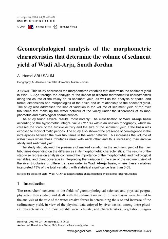
Research problem lies in the analysis of the geomorphological role of the morphometric characteristics in determining the size of the sedimentary yield in Wadi Al-Arja (Figure 1). These character-istics are exemplified in the formal and spatial dimension of the basin, the nature of the basin relief, and the morphometric dimensions of the water network of Wadi Al-Arja. These characteristics are directly linked to the environmental condi-tions of the basin, which makes their morphometric dimensions in a state of constant change. This change af-
Figure 1 The volume of sediment deposited on both sides of Wadi Al-Arja basin

Ali Hamdi ABU SALIM: Morphometric characteristics that determine the volume of sediment yield of Wadi Al-Arja 459
fects the dynamics of the river geomorphological processes that are associated with the sedimentary yield of the basin.
Accordingly, the research problem is trying to answer the following questions: What is the role of the spatial, formal and relief dimension of Wadi Al-Arja basin in
determining the volume of its sedimentary yield? What is the impact of the morphometric dimensions of the river tributaries of differ-
ent ranks within the water network of Wadi Al-Arja basin in determining the volume of its sedimentary yield?
What is the size of changes in the sedimentary yield of the river tributaries under the variation of their morphometric and hydrological characteristics along the longitudi-nal section of Wadi Al-Arja?
3 Research objectives
1. The analysis of the role of formal, spatial and morphological characteristics in de-termining the volume of the sedimentary yield of Wadi Al-Arja. The morphological role is illustrated in the analysis of relief values, the hypsometric integral and the sloping characteristics of the longitudinal profile of the valley and linking them to the sedimentary yield of the valley.
2. Studying the direct role of the valley’s water network characteristics in increasing the volume of its sedimentary yield.
3. Analysis of the size of variation in the sedimentary yield of the river’s tributaries in Al-Arja basin according to the difference in its stream order and its morphometric and hydrological characteristics.
4 Research methodology
The research methodology is based on two approaches, namely: the Practical Approach and the Analytical Approach. The Practical Approach is exemplified in determining the vegeta-tion coverage, conducting morphometric measurements for the tributaries of different stream order and measuring the volume of these tributaries water discharge, their flow speed, and their sediment concentration. A total of 120 water samples of tributaries of different stream orders were taken during the rainy season (2011/2012), with an average of 30 samples for each stream order, so as to measure the sediment concentration for each order and linking the measurement results with the morphometric and hydrological characteristics of the tributaries.
The Analytical Approach is exemplified in the analysis of the measurements results de-rived from the field, from 1:50,000-scale topographic maps for the year 2007, and from 1:25,000-scale aerial photos for the year 2010.
The measurements’ results have been processed using Stepwise Regression Model in or-der to identify some of the morphometric and hydrological variables that determine the volume of the river’s tributaries sedimentary yield at different stream order. A matrix of morphometric and hydrological variables which included 125 tributaries was subjected to statistical analysis; the most important of these variables were: the volume of water dis-charge, the speed of river flow, the width of the river, the length of the river, the gradient of
460 Journal of Geographical Sciences
the river, the length of the river tributary, the discharge density, and the stream order. The matrix also included the variable of vegetation coverage because of its importance in ex-plaining the variation in the volume of the sedimentary yield of the tributaries in Wadi Al-Arja basin.
4.1 Physical properties of the basin
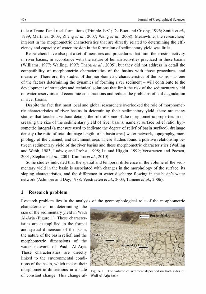
The Wadi Al-Arja basin lies in the southwestern part of Jordan. It extends between 35º29′–35º43′E and 30˚22′–30º27′N (Figure 2).
Figure 2 A space image of Wadi Al-Arja basin
The basin’s environment is classified within the Arid Lands. The effects of the drought
have reflected on the stability of the elements of the natural order of the basin: the climate, the soil, the vegetation and geology.
Instability of these elements makes constant changes to the volume of the sedimentary yield of the valley. The rise in the amount of rain above its annual average (250 mm) in
some years, and its concentration in winter with temperatures below 10℃ increases the
amount of water discharge of the river tributaries, which in turn, increases the capacity of the river to transport sediment towards the outlet.
In terms of soil, dry Calciorthid Soil covers approximately 51% of the area of the basin. This soil is characterized by coarse, loose and highly permeable particles, which has weak-ened the river tributaries water discharge capability of sediment transport within the middle and lower basin of Wadi Al-Arja. Moreover, the presence of this soil within dry moisture pattern has negatively affected its moisture content and particle cohesion due to weak mois-ture tensile forces between its particles. Dry Camborthid Soils spread within the lower part of the basin over an area of approximately 7% of the basin. It is characterized by its fine
Ali Hamdi ABU SALIM: Morphometric characteristics that determine the volume of sediment yield of Wadi Al-Arja 461
silty texture and its ability to retain moisture, which reduces the coefficient of leakage of water from the flows of water and increase its capability of sediment transport in the regions in which these types of soils are spread. For the upper basin, there are two types of soil: Xerochreptic Calciorthid Soil and Calcixerollic Xerochrept Soil. The spatial extension of the Xerochreptic Calciorthid Soil is estimated to be around 37% of the area of the basin. It is characterized by its coarse, loamy texture; and its weak structure which weakened its ability to resist the water erosion forces resulting from water flows that are formed in the upper basin after rainfall (Minister of Agriculture, 1993) The Calcixerollic Xerochrept Soil is lo-cated within semi-humid moisture pattern, and covers an area of approximately 5% of the basin. It is characterized by its muddy loamy texture, and due to its improved physical char-acteristics, it undergoes agricultural processes by the inhabitants of the region. These proc-esses add to its ability to be eroded by water flows, hence increasing the volume of the sedimentary yield that feeds the tributaries in the upper basin (Figure 3).
Vegetation has emerged as a geomorphologic factor that adversely affects the sedimentary yield of the valley. As the vegetation being spread along the river channels, it forms natural obstacle to the flow of runoff water in the tributaries of the river. This weakens their capa-bility of erosion due to the role of vegetation in enhancing the coherence of embankments materials and increasing water leakage. This role indicates the presence of a strong negative correlation between the size of the sedimentary yield and vegetation density. This relation-ship is clearly evident through the difference in the sediment concentration in the valley wa-ter according to the difference in the density of vegetation along the valley. The sediment concentration during the rainy season of 2011/2012 has increased in areas characterized by low vegetation density to 1301 mg/L, and decreased in areas with high vegetation density (513 mg/L); while the vegetation coverage along the valley ranged between 0 and 14.5%.
Geology was no less important than the other natural elements. The domination of lime-stone within the composition of Amman and Wadi Al-Sir in the upper stream, and being characterized by the lack of cohesion and weak construction accelerate its response to the forces of water erosion, and increase the amount of sediment carried by the upper tributaries. But its high permeability reduces its response to the forces of water erosion, due to increased water leakage coefficient within these configurations. While the dominance of alluvial sediments within the lower stream and on its sides has reduced its ability to transfer sedi-ments; due to the high water leakage coefficient of those formations and its high permeabil-ity (Figure 4).
4.2 Morphometric characteristics that determine the volume of sedimentary yield in Wadi Al-Arja
The morphometric characteristics of Wadi Al-Arja play an indirect role in determining the volume of its sedimentary yield because of their direct impact on the erosion forces of its tributaries and latter’s ability to transport sediment. The morphometric characteristics con-sist of a group of morphometric dimensions that are related to catchment’s area, shape, ter-rain characteristics, and water network features. The following is an explanation of the geomorphologic role of these characteristics in determining the volume of the sedimentary yield of Wadi Al-Arja.

462 Journal of Geographical Sciences
Figure 3 Types of soils in Wadi Al-Arja basin
Figure 4 Surface formations in Wadi Al-Arja basin
4.2.1 Catchment area
The catchment area occupied by the water network of Wadi Al-Arja constitutes the geomor-phological range in which the river tributaries exercise their erosion forces and the resulting
Ali Hamdi ABU SALIM: Morphometric characteristics that determine the volume of sediment yield of Wadi Al-Arja 463
sediment carried by those tributaries through their river channels to distances correspond with their capacity.
The small catchment area of Wadi Al-Arja (117.5 km2) increases the geomorphological effectiveness of the rain. The low rate of leaked and vaporized water works on developing tributaries with high watery discharge and erosion forces; and with high capability of trans-porting its sedimentary load.
The small catchment distance of the valley also works on the continuity of water flow in the river tributaries for long periods of time after rainfall due to the short period of time re-quired for the onset of the water flow in the river tributaries and for meeting with each other. Also, the increasing possibility of covering the small catchment area with rain storms in-creases the amount of water received by the catchment and increases the speed of its uni-formity in river channels, which increases the capability of the river tributaries on sediment transport and hence, increases the sedimentary yield of Wadi Al-Arja.
4.2.2 Catchment form
The catchment form is a product of water erosion forces exerted by the tributaries of Wadi Al-Arja water network as the catchment form is consistent with the morphometric dimen-sions of the tributaries. Also, the catchment form affects the dynamics of the river tributaries work on the formation of the morphology of the surface and determining the volume of their sedimentary yield. The catchment form was determined after calculating elongation ratio, the circularity ratio, and the form factor. These ratios have been measured according to the following mathematical equations:
Elongation ratio = the diameter of a circle with the same area as the catchment (km) divided by the maximum length of the catchment (km).
Circularity ratio = the catchment area (km2) divided by the area of a circle with the same circumference as the catchment (km2).
Form factor = the catchment area (km2) divided by square length of the catchment (km) (Salama, 1980).
The following describes the impact of the formal dimension of the catchment on the sedimentary yield of Wadi Al-Arja (Table 1):
1. The catchment has a rectangular shape, with an elongation ratio of 55%. This ratio has affected the morphometric dimensions of the tributaries of lower order, as these tributaries tend to minimize their length and increase their number to match the shape of the basin. This change in the tributaries longitudinal dimensions has an impact on the water flows hydrology in terms of increasing their size and their speed of reaching their estuaries faster than those tributaries of higher order; hence, esca-lating their geomorphological forces on eroding their channels and banks, and in-creasing their sedimentary yield.
2. Roundness ratio (56%) indicates roughness in the watershed area as gradient be-tween 7º and 28º. It also indicates that the watershed surrounding the catchment does not have a regular shape in some of its parts but it takes tortuous shape mark-edly. This leads to increasing the length of the tributaries of lower order at those parts which are often located near the watershed of the upper basin of the valley. The increase in the lengths of the upper tributaries helps to accommodate the
464 Journal of Geographical Sciences
amount of water received by the upper basin in its channels, and activate their abil-ity to move sediment toward the estuaries.
3. The catchment form factor (0.24) indicates the change in the dimensions that deter-mine its area. The catchment area widens as we approach the upstream as a result of the efficiency of water erosion forces towards the watershed of upper basin. This widening has led to an increase in the amount of rainfall received by the upper basin, hence, taking the form of canals, which in turn escalates the erosion forces of the tributaries spread along the watershed. While we find that the small area of the lower basin of the valley has reduced the amount of rainfall received by the tribu-taries which adversely affect the speed of forming water flows in those tributaries and their ability to transfer sedimentary load toward the main stream.
Table 1 Form and morphological characteristics of Al-Arja basin
Form characteristics Morphological characteristics
Circumference 51.6 km Relief ratio 27.5 m/km
Elongation ratio 0.55 Hypsometric integral 0.82
Circularity ratio 0.56 Texture ratio 0.48
Catchment form integral 0.24 Stream gradient 4.2o
4.2.3 Terrain characteristics
The relief characteristics of river basins identify the morphology of their surface and their responsiveness to river operations such as erosion, transport and deposition. The effective-ness of these operations increases if the surface is characterized by relief, and by the exis-tence of differences in height between the parts of the basin. The relief characteristics of river basins also determine the erosion stage reached by tributaries in the formation of their surface morphology, and what deposits can be produced by this stage under certain topog-raphy.
What follows is an analysis of some of the relief characteristics that determine the sedi-mentary yield of Wadi Al-Arja (Table 1):
(1) Relief ratio: The tectonic processes that affected the basin in previous geological periods caused clear
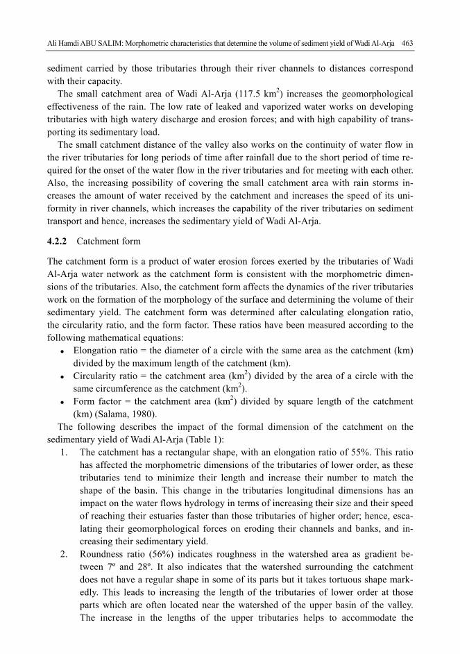
contrast in the levels of the surface which escalated its relief. Then the outer operations as-sociated with the forces of water erosion continued the formation of the morphology of the surface to increase its relief degree and its scarp. The high relief ratio of the basin (27.5 m/km) indicates the presence of evident differences in the levels of surface, as the highest areas of the basin reached 1650 m above sea level within the upper basin. While the lowest areas downstream reached 1060 m above sea level (Figure 5). And, when analyzing the ex-tent to which the relief is related to sedimentary yield, a positive relationship arises between the two. The river energy of the tributaries increases in the areas with most relief due to in-creased speed of water flows as water shear forces overcome the resistance forces of the components of the surface; and due to what results from the process of fragmentation of those components, hence, increasing the water flow capacity of the tributaries to transfer those fragments downstream. This process in turn increases the volume of sedimentary yield
Ali Hamdi ABU SALIM: Morphometric characteristics that determine the volume of sediment yield of Wadi Al-Arja 465
of the valley (Inbar, 1992; Inoue, 1992; De Boer, 1996; Lu et al., 2003).
Figure 5 Contour lines for Wadi Al-Arja basin
(2) Hypsometric integral: The hypsometric integral (HI) was measured according to the following equation:
minmax
minmean
HHH H
HI
where (Hmean) is the mean elevation of the catchment, Hmin is the mini-
mum elevation of the catchment, and Hmax is the maximum elevation of the catchment. HI can vary from 0 to 1 (Verstraeten and Poesen, 2001).
The hypsometric integral of Al-Arja basin (72.1%) indicates the presence of a very rough topography which increases the speed of forming water flows into the tributaries that feed into the main valley stream. The high hypsometric integral also indicates the short distance traveled by the soil particles and surface components resulting from water erosion forces during their journey from upstream towards the estuary. This limits the activity of sedimen-tation along the main valley stream and increases the volume of sediment transported by the valley to its estuary.
(3) Texture ratio: The texture ratio represents the ratio of total aliasing in any contour line of a water basin
to the length of its circumference as basins surfaces in which texture ratio is less than 4 are characterized by coarse texture (Smith, 1950). It also indicates the degree of convergence or divergence of the tributaries, which directly affects the hydrological characteristics of these tributaries and their sedimentary yield. The textile ratio of Wadi Al-Arja (0.48) indicates a coarse surface and a convergence between its tributaries, and this convergence reflects posi-tively on the speed of which these tributaries meet each other as well as it causes a reduction in the rate of water loss of the tributaries of the river. This increases their erosion capability
466 Journal of Geographical Sciences
and sedimentary load, where such a load is an important part of the total sedimentary yield of Wadi Al-Arja.
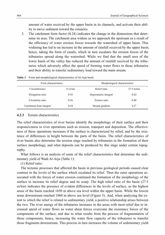
(4) Longitudinal profile of the valley: Figure 6 shows the variation in the sloping characteristics of Wadi Al-Arja according to
the differences in the natural conditions and hydrological characteristics of the basin, where these variables interact to determine the overall shape of the sector from the upstream to the downstream environment.
Figure 6 Longitudinal section of Wadi Al-Arja stream
The gradient changes alongside the stream in the upstream area with a value of 6˚9′– 3˚7′
Then the gradient values of the stream begin to decrease gradually while moving towards the downstream area to reach 3º5′–1º4′. This change is explained by the change in the vertical erosion ratio experienced by the river bed as a result of water flow flowing in the main stream, where the vertical erosion forces increase according to the increase in its drainage volume and flow speed, and the notable increase in the gradient of the stream that follows and the increase in the water flow ability to transport sediment towards the downstream area.
The difference in the characteristics of rock formations of the stream bed and the extent to which it is covered with sediments and rock fragments determine the erosion capability of water flow; where this capability increases in limestone which is characterized by low hard-ness, and decreases in igneous rocks which is characterized by its hardness and its resistance to vertical and lateral erosion. The presence of numerous short sloping parts which occupies a high proportion of the total sloping lengths indicates irregularity in the longitudinal profile of the valley. The ratio of sloping parts that have a length less than 250 m reached 63.4% of the total sloping parts in the longitudinal profile of the valley.
The increase in the gradient of the valley in some places directly affected the volume of its sedimentary load, as a result of the role of the gradient in increasing the amount of drainage water and the speed of flow; hence, increasing the erosion capability of the valley on trenching its bed and eroding its banks, and thus increasing its sedimentary yield.
Figure 7 shows the positive relationship between the gradient in the stream and the sedi-ment concentration in some places in the upper basin, where the gradient variable interpreted about 84% of the variance in the volume of the sedimentary yield at locations in which the sediment concentration was measured. The sediment concentration at those locations has ranged between 150 and 750 mg/L). While the rate of the stream gradient ranged between
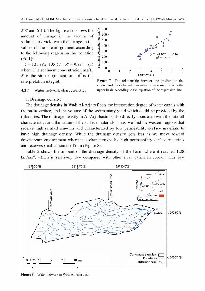
Ali Hamdi ABU SALIM: Morphometric characteristics that determine the volume of sediment yield of Wadi Al-Arja 467
2º8′ and 6º4′). The figure also shows the amount of change in the volume of sedimentary yield with the change in the values of the stream gradient according to the following regression line equation (Eq.1):
Y = 121.88X–135.67 R2 = 0.837 (1) where Y is sediment concentration mg/L, X is the stream gradient, and R2 is the interpretation integral.
4.2.4 Water network characteristics
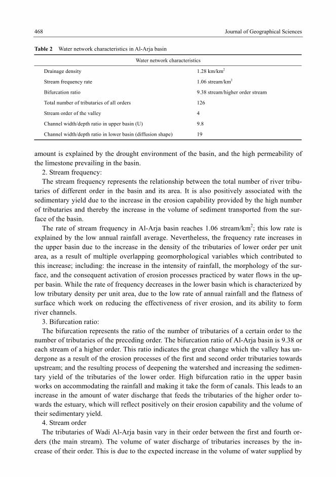
1. Drainage density: The drainage density in Wadi Al-Arja reflects the intersection degree of water canals with
the basin surface, and the volume of the sedimentary yield which could be provided by the tributaries. The drainage density in Al-Arja basin is also directly associated with the rainfall characteristics and the nature of the surface materials. Thus, we find the western regions that receive high rainfall amounts and characterized by low permeability surface materials to have high drainage density. While the drainage density gets less as we move toward downstream environment where it is characterized by high permeability surface materials and receives small amounts of rain (Figure 8).
Table 2 shows the amount of the drainage density of the basin where it reached 1.28 km/km2, which is relatively low compared with other river basins in Jordan. This low
Figure 8 Water network in Wadi Al-Arja basin
Figure 7 The relationship between the gradient in the stream and the sediment concentration in some places in the upper basin according to the equation of the regression line
468 Journal of Geographical Sciences
Table 2 Water network characteristics in Al-Arja basin
Water network characteristics
Drainage density 1.28 km/km2
Stream frequency rate 1.06 stream/km2
Bifurcation ratio 9.38 stream/higher order stream
Total number of tributaries of all orders 126
Stream order of the valley 4
Channel width/depth ratio in upper basin (U) 9.8
Channel width/depth ratio in lower basin (diffusion shape) 19
amount is explained by the drought environment of the basin, and the high permeability of the limestone prevailing in the basin.
2. Stream frequency: The stream frequency represents the relationship between the total number of river tribu-
taries of different order in the basin and its area. It is also positively associated with the sedimentary yield due to the increase in the erosion capability provided by the high number of tributaries and thereby the increase in the volume of sediment transported from the sur-face of the basin.
The rate of stream frequency in Al-Arja basin reaches 1.06 stream/km2; this low rate is explained by the low annual rainfall average. Nevertheless, the frequency rate increases in the upper basin due to the increase in the density of the tributaries of lower order per unit area, as a result of multiple overlapping geomorphological variables which contributed to this increase; including: the increase in the intensity of rainfall, the morphology of the sur-face, and the consequent activation of erosion processes practiced by water flows in the up-per basin. While the rate of frequency decreases in the lower basin which is characterized by low tributary density per unit area, due to the low rate of annual rainfall and the flatness of surface which work on reducing the effectiveness of river erosion, and its ability to form river channels.
3. Bifurcation ratio: The bifurcation represents the ratio of the number of tributaries of a certain order to the
number of tributaries of the preceding order. The bifurcation ratio of Al-Arja basin is 9.38 or each stream of a higher order. This ratio indicates the great change which the valley has un-dergone as a result of the erosion processes of the first and second order tributaries towards upstream; and the resulting process of deepening the watershed and increasing the sedimen-tary yield of the tributaries of the lower order. High bifurcation ratio in the upper basin works on accommodating the rainfall and making it take the form of canals. This leads to an increase in the amount of water discharge that feeds the tributaries of the higher order to-wards the estuary, which will reflect positively on their erosion capability and the volume of their sedimentary yield.
4. Stream order The tributaries of Wadi Al-Arja basin vary in their order between the first and fourth or-
ders (the main stream). The volume of water discharge of tributaries increases by the in-crease of their order. This is due to the expected increase in the volume of water supplied by
Ali Hamdi ABU SALIM: Morphometric characteristics that determine the volume of sediment yield of Wadi Al-Arja 469
the tributaries flowing into tributaries of higher order. Therefore, the capability of tributaries of higher order to transport sediments and trench channels increases with the increase in their water discharge and stream energy. The water discharge in the tributaries of the first, second and third order was: 0.14 m3/s, 0.18 m3/s and 0.22 m3/s, respectively, while water discharge in the fourth order (main stream) was about 0.48 m3/s. The water discharge net-work of Wadi Al-Arja includes 126 tributaries, which vary in their morphometric and hy-drological characteristics. Table 3 shows those characteristics and their impact on the sedi-mentary yield of the tributaries, as follows:
1. The stream orders vary in number of their tributaries, where the first order acquired most of the tributaries (71); followed by second order (40); and then the third order (15); and finally the fourth order which represents the main stream of the valley. The tributaries of the first and second order form the backbone which feeds the main-stream with the sediment as water flow continues in their canals.
2. The presence of large number of tributaries of the first and second orders in the up-per stream region near the watershed of the basin has led to accommodate the amount of rainfall and made it take the form of canals; hence, providing the lower tributaries and the main stream of the valley with large quantities of water and sedi-ment.
3. The stream orders differ in their lengths and their gradient according to the differ-ence in their morphological characteristics. The tributaries of first order were char-acterized by being short and very steep, where their average length was 1.2 km, and their gradient was 3º8′. Those characteristics have contributed to the increase in the volume of the sedimentary yield of the valley, due to the increased speed of the water flow in these tributaries, and the short distance traveled by the water flow to the es-tuary area. This increases the stream energy and its capability to transport sediment. The tributaries of higher order (second and third) are characterized by an increase in their length and a low gradient. This adversely affects the volume of runoff water and its stream energy to transport sediment as a result of the slowdown in the speed of water flow in these tributaries. The gradient of those tributaries has ranged be-tween 2º1′ and 3º2′ and their average length ranged between 1.35 and 1.5 km.
4. The drainage density of the tributaries in Al-Arja basin increases as we move to lower stream orders. The drainage density of the first, second and third orders was 1.55 km/km2, 1.43 km/km2 and 1.29 km/km2, respectively. The increase in the drain-age density in the lower orders is due to being located near the watershed areas that receive large amounts of rain, which accelerates the formation of runoff water that has high capacity to trench the surface and take the form of well-defined canals.
5. The tributaries of different order vary in the volume of their sedimentary yield. The capability of the tributaries to transport sediment increases with the increase in their stream order, as a result of the increase in the volume of their water discharge and its energy to transport sediment. The average of water discharge of the tributaries has ranged between 0.14 m3/s for the first order, and 0.48 m3/s for the fourth order (the main stream). While the sediment concentration of these orders was 394 mg/L and 634 mg/L, respectively.
470 Journal of Geographical Sciences
Table 3 The morphometric characteristics of the tributaries and the volume of their sedimentary yield in Al-Arja basin
Stream order
Number of tribu-
taries
Average length of tributaries
(km)
Bifurcation stream/stream of preceding
order
Canal width/depth
ratio
Drainage density
(*) (km/km2)
Average of water
discharge (m3/s)
Sediment concentration
(mg/L)
First 71 1.25 1.78 6.6 1.55 0.14 394
Second 40 1.35 3.2 6.9 1.43 0.18 429
Third 15 1.5 15 7.5 1.29 0.22 518
Fourth (main stream)
1 9.1 – 7.8 0.66 0.48 634
* Drainage density of each order represents the ratio of the total length of tributaries of a certain order to basin area of the same order.
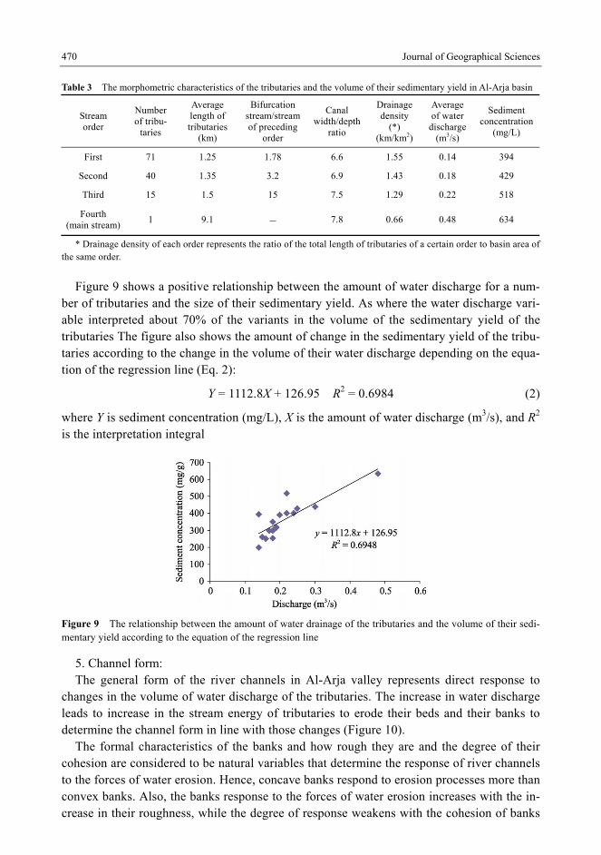
Figure 9 shows a positive relationship between the amount of water discharge for a num-ber of tributaries and the size of their sedimentary yield. As where the water discharge vari-able interpreted about 70% of the variants in the volume of the sedimentary yield of the tributaries The figure also shows the amount of change in the sedimentary yield of the tribu-taries according to the change in the volume of their water discharge depending on the equa-tion of the regression line (Eq. 2):
Y = 1112.8X + 126.95 R2 = 0.6984 (2)
where Y is sediment concentration (mg/L), X is the amount of water discharge (m3/s), and R2 is the interpretation integral
Figure 9 The relationship between the amount of water drainage of the tributaries and the volume of their sedi-mentary yield according to the equation of the regression line
5. Channel form: The general form of the river channels in Al-Arja valley represents direct response to
changes in the volume of water discharge of the tributaries. The increase in water discharge leads to increase in the stream energy of tributaries to erode their beds and their banks to determine the channel form in line with those changes (Figure 10).
The formal characteristics of the banks and how rough they are and the degree of their cohesion are considered to be natural variables that determine the response of river channels to the forces of water erosion. Hence, concave banks respond to erosion processes more than convex banks. Also, the banks response to the forces of water erosion increases with the in-crease in their roughness, while the degree of response weakens with the cohesion of banks
Ali Hamdi ABU SALIM: Morphometric characteristics that determine the volume of sediment yield of Wadi Al-Arja 471
and river beds materials.
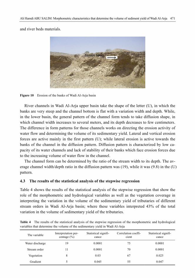
Figure 10 Erosion of the banks of Wadi Al-Arja basin
River channels in Wadi Al-Arja upper basin take the shape of the letter (U), in which the
banks are very steep and the channel bottom is flat with a variation width and depth. While, in the lower basin, the general pattern of the channel form tends to take diffusion shape, in which channel width increases to several meters, and its depth decreases to few centimeters. The difference in form patterns for those channels works on directing the erosion activity of water flow and determining the volume of its sedimentary yield. Lateral and vertical erosion forces are active mainly in the first pattern (U); while lateral erosion is active towards the banks of the channel in the diffusion pattern. Diffusion pattern is characterized by low ca-pacity of its water channels and lack of stability of their banks which face erosion forces due to the increasing volume of water flow in the channel.
The channel form can be determined by the ratio of the stream width to its depth. The av-erage channel width/depth ratio in the diffusion pattern was (19), while it was (9.8) in the (U) pattern.
4.3 The results of the statistical analysis of the stepwise regression
Table 4 shows the results of the statistical analysis of the stepwise regression that show the role of the morphometric and hydrological variables as well as the vegetation coverage in interpreting the variation in the volume of the sedimentary yield of tributaries of different stream orders in Wadi Al-Arja basin; where these variables interpreted 43% of the total variation in the volume of sedimentary yield of the tributaries. Table 4 The results of the statistical analysis of the stepwise regression of the morphometric and hydrological variables that determine the volume of the sedimentary yield in Wadi Al-Arja
The variable Interpretation per-
centage (%) Statistical signifi-
cance Correlation coeffi-
cient Statistical signifi-
cance
Water discharge 19 0.0001 75 0.0001
Stream order 11 0.0001 70 0.0001
Vegetation 8 0.03 67 0.025
Gradient 5 0.045 55 0.047
472 Journal of Geographical Sciences
The variable of water discharge ranked first in terms of importance in interpreting the variation in the volume of the sedimentary yield, as the percentage of interpretation for this variable accounted for 19% with statistical significance (0.0001); while the correlation coef-ficient indicated a strong relationship between the two variables (75%) with statistical sig-nificance (0.0001).
The stream order variable came in second place as it interpreted 11% of the total variation with statistical significance (0.0001); while the correlation coefficient indicated a positive relationship between the two variables (70%) with statistical significance (0.001). The vegetation variable ranked third, as it interpreted 8% of the variation with statistical signifi-cance (0.03); while the correlation coefficient indicated medium relationship between the two variables (0.67) with statistical significance (0.025).
The gradient variable came in fourth place as it interpreted 5% of the total variation with statistical significance (0.045); while the correlation coefficient indicated a moderate posi-tive relationship between the two variables (0.55) with statistical significance (0.047).
5 Results
The morphometric characteristics of Wadi Al-Arja basin have a direct impact on determining of the volume of its sedimentary yield, through its ability to determine the effectiveness of the tributaries in eroding their banks, beds, and the surface materials that make up the tribu-taries basins. The ability of the morphometric variables to increase sedimentary yield vary with the variation in the conditions of the valley basin.
The results of the study show the geomorphological role of the morphometric characteris-tics in determining the volume of the sedimentary yield in Wadi Al-Arja through a number of variables, including:
(1) The small basin area of Wadi Al-Arja works on increasing the geomorphological effi-ciency of rainfall speediness in forming water flows, and increasing the size of flow in the canals of the tributaries; thus, activating the water erosion forces of the tributaries and in-creasing the volume of their sedimentary yield.
(2) The texture of Wadi Al-Arja basin shows how close the intra distance between the tributaries of the water network is. This increases the volume of the discharged water flow-ing in those tributaries, as those tributaries meet with each other so quickly, thereby increas-ing their erosion capacity and sedimentary yield.
(3) The high value of the hypsometric integral (72.1%) classifies Al-Arja basin within the early stage of the erosion cycle and within a rough topography, which significantly increases the effectiveness of erosion activity and the volume of the sedimentary yield if moist cli-matic conditions would be available in the later periods.
(4) The variation in the gradient in Wadi Al-Arja directly affected the determining of the volume of its sedimentary yield, as the study results showed a positive relationship between the degree of stream gradient and the sediment concentration.
(5) The increase in the effectiveness of the tributaries in forming the sedimentary load with the increase in their stream order, due to the increase in their water drainage volume and their capacity of sediment transport. The rate of water drainage of the tributaries ranged between 0.14 m3/s for the first stream order and 0.48 m3/s for the fourth stream order, while

Ali Hamdi ABU SALIM: Morphometric characteristics that determine the volume of sediment yield of Wadi Al-Arja 473
the sediment concentration of these two orders was 394 mg/L and 634 mg/L, respectively. (6) The study showed the presence of marked variation in the sedimentary yield of the
tributaries of different stream order depending on their morphometric and hydrological data. The results of the statistical analysis of the stepwise regression showed the important role of the morphometric and hydrological variables, as well as the vegetation coverage, in inter-preting the variation in the volume of the sedimentary yield of the tributaries of different stream order in Wadi Al-Arja basin. Those variables interpreted 43% of the total variation in the volume of the sedimentary yield of the tributaries, with statistical significance less than 0.05. The water drainage variable ranked first by 19%, followed by the stream order variable (11%), next the vegetation variable (8%), and then the gradient variable (5%).
6 Recommendations
In light of the analysis of the morphometric variables and their relationship with the volume of the sedimentary yield in Wadi Al-Arja, we can define some recommendations that limit the direct role of these variables in increasing the volume of the sedimentary yield of the valley. These recommendations are as follows:
(1) The establishment of a number of earth dams in the upper basin to accommodate the largest amount of rainfall, and to limit the volume of water flow toward the tributaries of lower stream order that feed the tributaries of higher stream order.
(2) The construction of retaining walls on the banks of Wadi Al-Arja, in order to retain the components of banks and strengthen their resistance to water shears forces.
(3) Making a dynamic balance between the level of the water flowing in the tributaries channels and their holding capacity in the rainy months. This balance can be made by estab-lishing an artificial water network for excess water in areas that receive high water flows after rainfall, and using surplus water for the purposes of agricultural irrigation or livestock watering.
(4) Slowing down the pace of water flows in the watershed areas of Wadi Al-Arja basin by increasing the surface roughness through planting trees; thus, increasing water leakage rates, and reducing the speed of water flows that are formed after rainfall.
References
Ashmore P E, Day T J, 1988. Spatial and temporal patterns of suspended–sediment yield in the Saskatchewan
River basin. Canadian Journal of Earth Sciences, 25: 1450–1463.
De Boer D H, Crosby G, 1996. Specific sediment yield and drainage basin scale. In: Walling D E, Webb B W
(eds.). Erosion and Sediment Yield: Global and Regional Perspectives. IAHS, 236: 333–338.
Inbar M, 1992. Rates of fluvial erosion in basins with a Mediterranean climate type. Catena, 19: 393–409.
Inoue K, 1992. Downstream change in grain size of river bed sediments and its geomorphological implication in
the Kanto plain, central Japan. Geographical Review of Japan, 65: 75–89.
Kumma M, Lu X, Wang J et al., 2010. Basin-wide sediment trapping efficiency of emerging reservoirs along the
Mekong. Geomorphology, 1919(3–46): 181–197.
Lu X X, Ashmore P, Wang J, 2003. Sediment yield mapping in a large river basin: The Upper Yangtze, China.
Environmental Modeling and Software, 19: 339–353.
Lu X X, Higgitt D, 1999. Sediment yields variability in the Upper Yangtze. Earth Surface Processes & Landforms,
474 Journal of Geographical Sciences
24(11): 1077–1093.
Ludwig W, Probst J L, 1998. River sediment discharge to the oceans: Present-day controls and global budgets.
American Journal of Science, 298: 265–295.
Martinez J, 2003. A spatial information technology approach for the mapping and quantification of gully erosion.
Catena, 50(2–4): 293–308.
Ministry of Agriculture, 1993. National soil map and land use project. The Soil of Jordan, (1): 1-20.
Salama H, 1980. Geomorphological analysis of the morphometric characteristics of basins in Jordan. Journal of
Drasat, (1): 32–50.
Smith B, Baptista N, McAllister J, 1999. Sediment logical evidence of human impact on a near shore environment.
Applied Geography, 19(2): 153–177.
Smith K, 1950. Standards for grading texture of erosional topography. American Journal Sci., 248: 655–668.
Stephane B, Melanie B, Jean V, 2001. Drainage network expansion of the Salagou drainage basin (S. France): An
example of relief response to recent climate change? Terra Nova, 13: 214–219.
Tamene S J, Park R, Dikau P L et al., 2006. Analysis of factors determining sediment yield variability in the high
lands of northern Ethiopia. Geomorphology, 6: 76–91.
Thapa B, Raju S, Biraj S, 2005. Problems of Nepalese hydropower projects due to suspended sediments. Aquatic
Ecosystem Health and Management, 8: 251–257.
Trimble S W, 1981. Changes in sediment storage in the Coon Creek basin, Driftless Area, Wisconsin, 1853–1975.
Science, 214: 181–183.
Verstraeten G, Poeson J, 2001. Factors controlling sediment yield from small intensively cultivated catchments in
a temperate humid climate. Geomorphology, 40: 123–144.
Walling D E, 1997. The response of sediment yields to environmental change. In: Human Impact on Erosion and
Sediment Yield. IAHS, 245: 77–89.
Walling D E, Webb B W, 1983. Patterns of sediment yield. In: Gregory K J (ed.). Background to Palaeohydrology.
John Wiley & Sons Ltd., 69–100.
Wang X, Shang S, Yang W et al., 2008. Simulation of land use-soil interactive effects on water and sediment
yields at watershed scale. Ecological Engineering, 36(3): 328–344.
Williams J R, 1977. Sediment delivery ratios determined with sediment and runoff models. IAHS, 122: 168–179.
Zheng M, Cal Q, Chen H, 2007. Effect of vegetation on the runoff–sediment yield relationship at different spatial
scales in hilly areas of the Loess Plateau, North China. Acta Ecologica Sinica, 27(9): 3572–3581.