Reflections on leadership - a geography subject leader perspective
Ministry of Education
Secondary Education Modernization Projec t
Consultancy Phase »»
(Funded by ADB / NDF Loan No.356)
DRAFT
FINAL REPORT
GEOGRAPHY SUBJECT
Professor KNJ Katupotha Domestic Consultant/Geography Subject.
SEMP-PHASE ll (ADB/NDF No: 356
AUGUST 2004
SUBMITTED BY
Helsinki Consulting Group oy Ltd
HELSINKI FINLAND
SEMP

Helsinki Consulting Group Ltd, Visiting Address: Kaisaniemenikatu 6 A, 6th Floor Postal Aggree: P. O. Box 1300 FIN-00101 Helsinki, Finland Telephone (int) + 358 9 191 44455 Fax (int) +358 9191 44453 E-mail:[email protected] Internet: www.hcg.helsinki.f
Sri Lanka Project Office: 11 Annasikotuwa Road, Depanama. Pannipitiya 10230, Sri Lanka
Tele +9411 2890654/2850033 Fax9411 2890754 E-mail: [email protected]
Resident Representative: Chris S Nawaratna
CONTENTS
iii
Abbreviations v
Executive Summary
Acknowledgments
vii
1 Geography Subject 1
1.1 Introduction 1
1.2 Dimensions of Geography Education 3
1.3 Strengthening Geographical Education 4
1.4 Quality Improvement - The SEMP Geography Subject
Component
6
1.4.1 Terms of Reference 6
2 Geography Curriculum Design 7
2.1 Introduction 7
2.2 Curriculum Content 9
3 The Geography Curriculum For Grades 10-13 (GCE OL & AL) 11
3.1 Strengths and Weaknesses 11
3.1.1 Grades 10-11 (GCE OL) – Geography Syllabus 12
3.1.2 Grades 12-13 (GCE AL) – Geography Syllabus 16
3.2 Practical Difficulties in the Implementation of the Existing
Geography Curricula
18
4 Improving the Geography Subject Curriculum 19
4.1 Moderniziong Of Geography Curricula 19
4.2 Recommendations Relevant to Grades 10-11 (GCE O/L) 20
4.3 Common Recommendations Relevant to Grades 11 - 13 (GCE
O/L& A/L)
30
4.4 Computer Assisted Learning (CAL) 32
5 Implementation of Modernized Curriculum 36
5.1 Necessity of Implementation 36
5.2 Teachers Capacity Building Measures 38
5.3 Facilities and required Resources 41
5.4 Institutional Development 44
5.5 Textbooks 45
6 Career Development and Employability 49
7 Summary of Recommendations 53
References 56

ii
APPEDICES
1 Number of (a) candidates sat for GCE OL and (b) GCE AL
Examinations and results by Grades. (c) Indicates the number
of Geography students who applied and selected candidates
for Universities
57
2 Draft of the proposed Geography Syllabus for Grade 10 -
Suggested Themes and Topics
58
3 Draft of the proposed Geography Syllabus for Grade 11 -
Suggested Themes and Topics
62
4 Proposed objectives, key issues and concepts, suggested
learning activities, suggested learning resources, skills, and
attitudes for Grades 10 and 11
66
5 Draft of the proposed Geography Syllabus (Geography Paper
1 - Physical Environment) for Grades 12 – 13. Suggested
themes and topics
75
6 Proposed objectives, key issues and concepts, suggested
learning activities, suggested learning resources, skills, and
attitudes for Geography Paper 1, Grades 12-13
80
7 Draft of the proposed Geography Syllabus (Geography Paper
II - People and Human Geography) for Grade 12-13.
Suggested themes and topics
89
8 Proposed objectives, key issues and concepts, suggested
learning activities, suggested learning resources, skills, and
attitudes for Geography Paper II, Grades 12-13
93
9 Action plan for modernizing Grades (10 - 11) Geography
Curriculum
99
10 Action plan for modernizing Grades (12 - 13) Geography
Curriculum
100
11 List of equipment for the Environmental Field Centres
(Resource Centres) – on site
101
12 Assessment mobility, teaching-learning aspects and
significant linkages with basic competencies
103
13 List of equipment and cadre position for proposed
cartography laboratory
108
14 Cost estimate for proposed Action plan, GCE (OL) 109
15 Cost estimate for proposed Action plan, GCE (AL) 112

iii
ABBRIVIATIONS
ADB Asian Development Bank BC before Christ BMV Balika Maha Vidyalaya CAL Computer Assistance Learning CCD Coast Conservation Department CD CEA
Compact disks Central Environmental Authority
CLC Computer Learning Centres CPOs Counterpart Officers DDE Deputy Director of Education DoE Department of education EFC Environmental Field Centre EPD Education Publication Department FAO The UN Food and Agriculture organization FD Forest Department G7 Economic and Political forum for seven of the world’s most
industrialized nations: Canada, France,Germany, Italy, Japan, Great Britain and the United States.
GCE O/L General Certificate Education (Ordinary Level) GCE A/L General Certificate Education (Advanced Level) GDP Gross Domestic Product GEP 2 German Education Progeamme GIS Geographic Information System GM GNP Gross National Product GSMB Geological Survey and mines bureau HDI Human Devolopment Index ICT Information Communication Technology IN India IPCC Intergovernmental Panel on Climate Change ISAs Human Resource Development IUCN The World Conservation union JICA Japan International Cooperation Agency JP Japan MAB Man and Biosphere MD Meteorological Department MMV Madya Maha Vidyalaya MS Model School MV Maha Vidyalaya NARA National Aquatic Resources Research and Devolopment
Agency NBRO National Building Research Organization NDF Nordic Development Fund NEC National Education Commission NETS National Education Testing Service

iv
NGOs Non Governmental Organizations
NIE National Institute of Education
NVQ National Vocational Qualifications
NW Norway
OPEC Organization of Prtroleum Exporting Countries
PAM Project Administration Memorandum
PEO Provincial Education Office
PPP Purchasing Power Parity
PQLI Physical Quality of Life Index
SAARC South Asian Association for Regional Cooperation
SBA School-based assessment
SBM School-based management
SEMP Secondary Education Modernization Project
SFCP School-focused curriculum programmes
SLTB Sri Lanka Tourist Board
TB Textbook
TEVT technical education and vocational training
TG Teacher guide
UK United Kingdom
UNDP
UNDP
United Nations Development Program
United Nations Development Program
UNFPA United Nations Population Fund
USA United State of America
WB World Bank
WHO World Health Organization
WTO World Trade Organization
ZEO Zonal Education Officer

v
EXCECUTIVE SUMMARY Based on my TOR (Chapter 1, Section 1.4), the quality improvement in grades 10-13 in Secondary Education was expected through strengthening of curriculum subjects. Geography was one of the selected subjects. The strengthening process for this subject was commenced at the beginning of January 2004 (for 6 person-months). The quality improvement and strengthening of secondary school curriculum emphasize that the general education system has a major role to play in cultural, social, scientific and technological development of Sri Lanka. Chapter 1 in this report discusses the significance of learning Geography in general education. During the last five decades in Sri Lanka, the general school education and even university education have been very teacher-centred, but they should become student-centred and activity-based. Thus, teaching should ensure that geographical enquiry and skills are used when developing knowledge and understanding of places, patterns and processes, and environmental change as well as sustainable development. Furthermore this chapter highlights emphasize that when quality improvements of the geography curricula should be reflect that every student learner is uniqe with differences in age, learning ability, interests, aptitudes, attitudes, motivation, and social backgrounds. Further, the curriculum is influenced by continuing and changing needs of the individual and the society. It is also influenced by inputs from new knowledge and skills acquired through research and development in the field of geography. The design of geography curriculum is explained in Chapter 2. There are many forms of curriculum designs, but they share some common qualities as: scope, sequence continuity, articulation and balance, which have been discussed in detail. The existing geography curriculum has clearly affected the number of students and the pass rates. Strengths and weaknesses of the existing geography curriculum of grades 10-13 are highlighted in Chapter 3. The section 3.1 in this chapter discusses the strengths and weaknesses of the existing geography syllabus, teachers’ guide and the textbook of the grades 10-11 (GCE OL). Similarly, the section 3.1.2 shows the strengths and weaknesses of the geography syllabus teachers’ guides and textbooks in grades 12-13 (GCE AL). The practical difficulties, in implementing of the geography curricula are pointed out in Section 3.2. Chapter 4 depicts the improving of geography subject curriculum. In Sections 4.1 – 4.3, the modernizing of the geography curriculum is explained. Recommendations relating to grades 10-11 and common recommendations for grades 10-13 are given. In these recommendations, 1-6 emphasize improvement of grades 10-11 geography. Recommendations 7-8 are mainly related to the assessment procedure and designing of learning materials. Recommendations for the use of computers in school education and are indicated in 9-10.

vi
Chapter 5 discusses nine recommendations, implementation of the geography curriculum, teachers’ capacity building measures, development of teachers training programmes, facilities & required resources, institutional development and improvement of textbooks etc. In Chapter 6, the significance of career development and employability is discussed. Counselling and guidance are needed for students and school leavers. Awareness programmes should be conducted to change the negative attitude of policy makers and decision makers. Further, this chapter emphasizes the necessary development of skills and predispositions that are required to meet the demands of the competitive labour market in geography there is no a labour market in the geography ‘’subject’’. However, there may be geography related job market. The eligibility of students who study geography in both junior and senior secondary education, for technical or vocational training, and the establishment of proper counselling and career-guidance units to find employment opportunities, are discussed in this chapter. Finally, a summary of all 22 recommendations from Chapters 4, 5 is presented.
vii
ACKNOWLEDGMENT
I am most grateful to those, who supported me in the National Institute of Education (NIE), Maharagama. My grateful thanks are extended to Dr. G. B. Gunawardena (former Director General of the NIE), Mr. B.L R. Rohana Kumara (Project Officer-NIE), Ms. M.P. Ranjani Dhanawardena (Project Officer) and Mr. Kinsley Priyantha (Assistant Project Officer) for continued support shown throughout the period of consultancy. Ms. Dhanawardene and Mr. Priyantha gave me their full support as Counterpart Officers in order to complete this assignment. Likewise, I also thank D.G. Professor Jagath Wickramasinghe for his encouragement and help. I acknowledge the support of Former team leader Mr. Peter Gam and present tem leader Mr. Hans Butenschon (SEMP Office II, NETS). My gratitude also goes to Mr. W.M.J. Pushpakumara (DCMoE – NETS), and his staff and Mr. K.G. Pushpakumara (DDE, MoE). I owe a special word of thanks to Mrs. Subita Navaratna (SEMP Office III, NIE) and her staff including Mr. C. Munasinghe and others.
I remember with pleasure all the stimulating discussion with Mr. Anura Dissanayake, Project Director, who has always been a positive influence. Likewise Mr. Nihal Herath, the Technical Advisor and Mr. Chris Nawaratna, Project Manager, deserve thanks for their cordial support. My special thanks go to Professor Nimal Dangalla and all other members of the universities, all invited officers of government departments and institutions, IASs, resource persons, geography teachers, and EFCs who helped me to modernize the Geography Curriculum. I wish to thank all Domestic and International fellow specialists who helped me in different ways with my work. Finally, I thank Dr. Alan Parkes and Dr. Kamal de Abrew, who provided valuable support on the manuscript.
Professor KNJ Katupotha Domestic Consultant/Geography Subject. SEMP-PHASE ll (ADB/NDF No: 356

1
1.
GEOGRAPHY SUBJECT
1.1 INTRODUCTION
“While Sri Lanka has achieved progress in basic human development, it has been unable to
translate these achievements into broad-based, sustainable economic growth. Worse still, the
rural poor have not had equal access to human resources necessary to acquire social and
physical capital. A key reason for this failure to achieve more rapid economic growth with
greater equity is the deficiency of the education system” (PAM, 2001). This emphasizes the
fact that the general education system has a major role to play in Cultural, Social,
Scientific and Technological development of Sri Lanka.
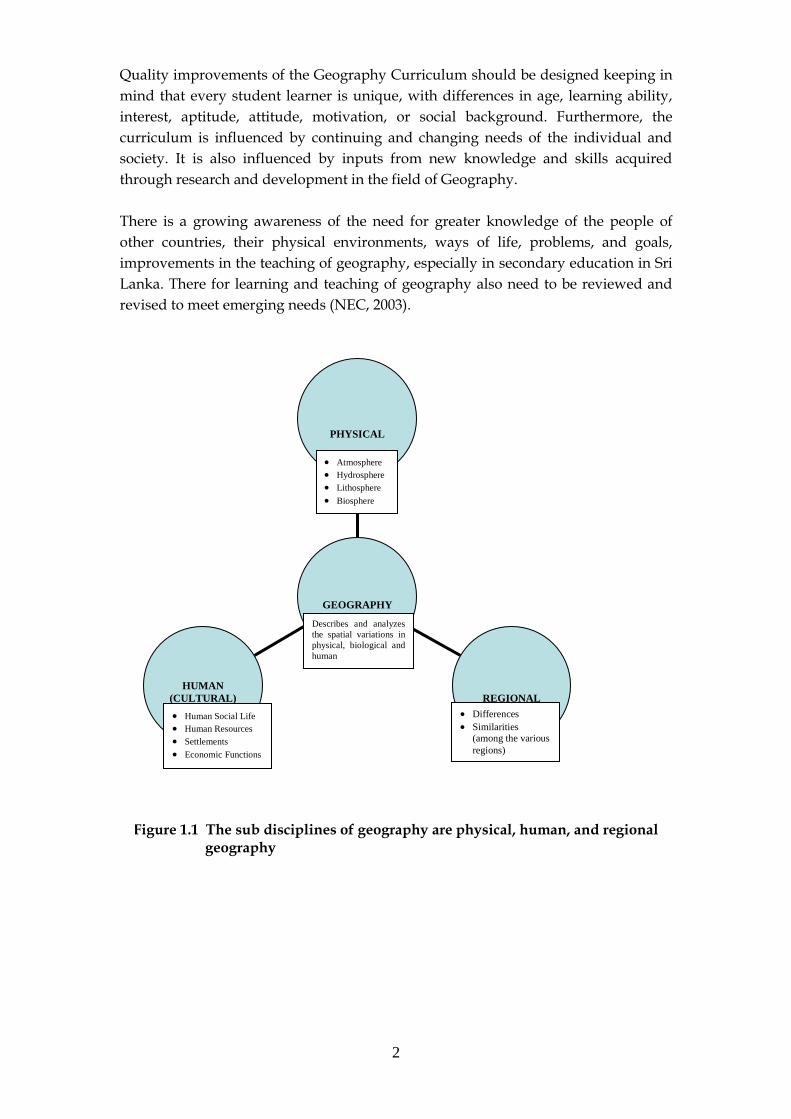
Geography describes and analyzes the spatial variations in physical, biological, and
human phenomena that occur on the surface of the Earth. Likewise, this subject
considers their interrelationships and their significant regional patterns. The sub
disciplines of geography are physical, human, and regional geography (Figure 1.1).
Physical geographic features include the climate, land and water, and plant and
animal life. In this category particular attention has been paid to coastal areas, to
water and mineral resources (including energy), and to natural hazards. Human
geographic features include artificial entities, such as nations, settlements, lines of
communication, transportation, buildings, and other modifications of the physical
geographic environment. Environmental management and conservation of resources
fall between these two large fields.
The scale of study in regional geography may range from worldwide regionalization,
to a continent, a major cultural area, a country, a sub region within a country, or a
city. Consequently, geographers use economics, history, biology, geology,
climatology and mathematics in their studies, which integrate cultural, scientific and
technological development with physical geographic features. Teaching should
therefore ensure that geographical enquiry and skills are used when developing
knowledge and understanding of places, patterns and processes, and environmental
change as well as sustainable development are understood.
Five fundamental themes in Geography have been identified to meet the National
Education Goals in the United States: location, place, and relationship within the
places, movement and region. In its inclusion of themes, both in England and Wales
and the USA, geography has been identified as a uniquely useful subject in creating
bridges between the humanities and sciences, and between social sciences. It also has
a distinctive role in pursuing its objectives at local, regional, national, continental and
global scales (Husen and Postlethwaite, 1995).
2
Quality improvements of the Geography Curriculum should be designed keeping in
mind that every student learner is unique, with differences in age, learning ability,
interest, aptitude, attitude, motivation, or social background. Furthermore, the
curriculum is influenced by continuing and changing needs of the individual and
society. It is also influenced by inputs from new knowledge and skills acquired
through research and development in the field of Geography.
There is a growing awareness of the need for greater knowledge of the people of
other countries, their physical environments, ways of life, problems, and goals,
improvements in the teaching of geography, especially in secondary education in Sri
Lanka. There for learning and teaching of geography also need to be reviewed and
revised to meet emerging needs (NEC, 2003).
HUMAN
(CULTURAL)
REGIONAL
PHYSICAL
GEOGRAPHY
Atmosphere
Hydrosphere
Lithosphere
Biosphere
Describes and analyzes
the spatial variations in
physical, biological and
human
Human Social Life
Human Resources
Settlements
Economic Functions
Differences
Similarities (among the various
regions)
Figure 1.1 The sub disciplines of geography are physical, human, and regional geography
3
1.2 DIMENSIONS OF GEOGRAPHY EDUCATION
The word ―geography‖ was adopted in the third century by the Greek scholar
Eratosthenes and means ―earth description‖. Scientific evidence shows that the
physical and behavioral traits shared by all people evolved over a period of at least 6
million years, facing different physical geographic environments. Man faced a
lengthy process of change, building up civilizations, which were in an advanced state
of a society possessing historical and cultural unity. Likewise, human beings
confronted natural disasters, such as floods, droughts, earthquakes, volcanic
eruptions etc. Moreover, ancient peoples such as the Chinese, Egyptians, and
Phoenicians, made long journeys and recorded their observations of strange lands.
All these imply that the physical and behavioral linkages existed throughout
evolution and their study has been significant in the improvement and strengthening
of the subject of geography.
In Sri Lanka, Geography became a neglected subject at all levels in school education,
following integration with History and Civics as Social Studies in 1972. This science
has never played so conspicuous a role, or so widely engaged public attention, by
1942. To some degree, depending chiefly upon the layperson's alertness to
contemporary news, everyone recognized more than ever before the impelling
influence of the geographic environment upon the forces and events that made
history in the Second World War. Before this, geography had been relegated to a
minor place in the curricular program of higher institutions of learning, well-nigh
banished from high schools, and reduced to a subordinate place even in grade-school
programs, where it was considered to have some a cultural value. Now it has come
recognized as one of the two most vital fields of study for the useful and intelligent
interpretation of human physical and cultural character, on a par with history, and
similarly indispensable.
Thus, geography occupies a distinctive place in the world of learning, offering an
integrated study of the complex reciprocal relationship between human societies and
the physical environments of the Earth. The geographer‘s canvas is coloured by
place, space and time, recognizing the great differences and dynamics in cultures,
political systems, economics, landscapes and environments across the world, and the
links between them (Subject Benchmarking Statements, Quality Assurance Agency,
UK, 2000). This shows that geography as a branch of learning has focused on
understanding the relationship between man and nature.
However, during the past three decades, Geography has remained a neglected
discipline in Junior and Senior education due to the extensive curriculum reforms in
Sri Lanka, since 1972. Under these reforms, the teaching of History, Geography and
Civics from Grade 6 was replaced by social studies, which was intended to integrate
the three subjects. The integration of these content areas in the social studies
curriculum did not take place, however, and teachers continued to confine
themselves to their own areas of subject specialization, thereby undermining the
expected outcomes of integration.
4
The NEC Report (2003) emphasizes that there was a strong demand during the
public consultations, seminars and studies that the Social Science component of the
curriculum should have separate subjects (History, Geography and Civics) as is the
practice in most countries. Geography, in some ways is stated to have survived in
spite of its integration into social studies. Nevertheless, the learning and teaching
techniques in geography also need to be revived and revised to meet emerging needs
(NEC, 2003).
Cultural (human) and physical Geography are the two traditional divisions in the
subject. However, in recent years, a third category of ―Environmental Geography‖
has sometimes been recognized at higher education level, and encompasses many
courses that deal definitely with human environmental relations and sustainable
development, and building upon the role of Geography in schools as the main
discussion platform for environmental concerns. This emphasizes the fact that a
sound knowledge of geography (as an interdisciplinary and multidisciplinary subject
– supportive subject) at secondary education level is essential to provide qualified
entrants for higher education, teacher training, and other courses in tertiary and post
secondary education and training.
1.3 Strengthening Geographical Education
SEMP has three components: (i) quality, (ii) access, and (iii) efficiency (PAM 2001).
The teaching of geography in secondary schools should be strengthened and
enriched by adopting teaching processes that provide the students with the
opportunity (NEC 2003):
(a) to acquire a wide range of transferable skills such as collecting and
analyzing statistical data, forming calculations, and reading and
constructing maps (using globes, atlases, satellite images and ICT)
(b) to engage in geographical inquiry inside and outside the classroom to
learn about a wide range of people, places and environments, and the
interface between humans and the environment.
Adapting to the learning process includes development of learning materials, and
redevelopment and training of schoolteachers in the application of activity-based
learning including monitoring, studies, and evaluation of these activities.
Geography courses at School level in Sri Lanka (Grades 10-13) can cover a wide
range of issues and locations. Beaumont at el (1997) stress that research shows that
with students of school age, issues such as care of the environment, protection of
fragile landscapes and the effects of global warming are very important. Likewise,
geography makes a contribution to general education as an auxiliary discipline.
Higher Education Institutions and employers are impressed by applicants who have

5
a grasp of what is going on around them, locally, nationally and internationally. A
geography course also helps develop useful skills such as questioning, problem
solving and decision-making. Furthermore, Geography students follow the
vocational route after GCE OL and AL; Geography can offer interesting employment
opportunities. As the world‘s largest industry, the tourist industry provides an
obvious outlet for students from National Vocational Courses such as Travel and
Tourism and Hotel Management.
It is interesting to note that the most popular areas of employment for geography
students are in agriculture, industry, environmental protection and planning,
administration and operational management, together with research, design and
development. All these areas reflect the need for strengthening geographical
education by investigating, problem solving and decision making skills. Different
types of International Geographical Congresses, Unions, Seminars/Workshops,
Protocols etc. indicates that Geography was a widespread subject about 65 years ago
(Collier‘s year Book 1938-1966: Geography).
To keep abreast of the news, to evaluate the significance of current events, to
understand the course of international relations in all their aspects, all intelligent
citizens have had to refresh their knowledge of geography and supplement it by
learning new facts and ideas about lands and seas, rivers and mountains, ports and
provinces, of which he or she had never before heard. Similarly, the change in
methodology in the 1950s and 1960s was so rapid that it is sometimes called the
―quantitative revolution‖. Geographers have also broadened their efforts to find
practical applications for geographic studies (Collier's Year Book, 1940: Geography,
Encarta Encyclopedia, 2004)
By the 1960s the field of geography had been divided into several schools of thought.
Disagreement between scholars of different schools—such as those who supported
the quantitative method and those who favored the descriptive approach—
sometimes arose. Since the 1970s, however, different methods have been commonly
used together and applied to many new areas of geographic study. During the 1960s,
the Canadian government built the first Geographic Information System (GIS), a
computer system that records, stores, and analyzes geographic information. These
computer systems can create two- or three-dimensional images of areas that are used
as models in geographic studies. They are designed to process massive amounts of
data and help scientists conduct research much more quickly and accurately. The
GIS has many applications in government and business.
Human beings are complex creatures full of prejudices, sympathies, and antipathies,
all of which distort and circumscribe the power of reason on the physical world. If a
person did not care for others, had no fellow-feeling for them, or thought them
subhuman, that person would not take their interests into account and would find
all kinds of reasons to ignore those interests. This leads to the destruction of physical
and human environments. Therefore, for teaching of geography should ensure that
geographical enquiry and skills are used when developing knowledge and

6
understanding of places, patterns and processes, environmental change, sustainable
development and the visibility of human communities. As mentioned earlier, all
these reflect that in the strengthening of geographical education emphasis on
investigating, problem solving and decision making are very significant in widening
the labour market through the Geography Curriculum in the secondary education
system.
1.4 QUALITY IMPROVEMENT - THE SEMP GEOGRAPHY SUBJECT COMPONENT
To improve the quality of the Geography subject, SEMP defines the following Terms
of Reference.
1.4.1 Terms of Reference
i Support NIE in the preparation of a timed, phased, prioritized and
costed Action Plan for increasing labour market orientation of the
geography Subject curriculum and development of a new generation
of learning materials including measures for (i) Institutional
development; (ii) Teacher Education; (iii) Materials revision and
development; (iv) School Based Assessment implemented by the
DoE/NETS (v) Determination of facilities and materials requirements.
Ensure that measures are appropriately coordinated with other
Action Plans for the Action Program of the Sub-Project.
ii Support NIE in the implementation of measures contained in the
Action Plan and develop monitoring and evaluating systems and
indicators for implementation of the Plan.
iii Organize a program of training and other capacity building measures
for MoE, NIE and other relevant institutions to help ensure the
sustained, efficient and effective achievement of measures foreseen in
the Action Plan.
iv Provide advisory input to upgrading Educating Technologies to
develop a programme of Geography learning utilizing the CLCs
established under the project
v. Liaison with International Consultants where necessary and
vi Any other relevant work connected with the Sub-Project.

7
2.
Geography Curriculum Design
2.1 INTRODUCTION
Curriculum development is the process of translating educational objectives into course content and educational strategies (Comings and Kahler, 1984). Curriculum design for any type of project involves a five-step process: setting goals; setting objectives to meet those goals; defining and sequencing learning activities that support the objectives; identifying resources; and writing lessons plans.
The Curriculum Development component of the SEMP is expected to propose inputs to ―Improve the quality of teaching and learning in schools‖. To develop learning ability in students, it is necessary that a well-developed curriculum in Geography is prepared and implemented in schools. The curriculum so designed should take into account the project goal of the SEMP, which is “To provide the youth leaving school, especially after GCE A Level, the skills and predispositions required for meeting the demands of a competitive job market and to find productive employments”. It is therefore appropriate to review the existing Grades 10-13 Geography Curricula before changes are recommended or a new curriculum is proposed.
Geography helps students develop skills in many areas: literacy, numeracy, analysis, individual research, group discussion and the synthesis of facts, figures, ideas and perspectives. This provides them with ideal preparation for decision making in other subjects later when they start work. There is a huge variety of careers related to geography: earth sciences, agriculture, economics, education, environmental management, information services, business and finance, scientific services, management and administration as well as leisure, travel and tourism. Geography is the study of people and places, particularly locations, society-land relations and regional differentiations.
The form of curriculum design qualities is also very significant in order to reach the SEMP project goals. There are many forms of curriculum design, but they share common curriculum design qualities that can be identified as: Scope, Sequence
Continuity, Articulation and Balance (Fernando, 2003). Accordingly, a curriculum scope refers to the breadth of the curriculum at any level, at any given time. The breadth of Grades 10 -13 (GCE OL and AL) Geography curricula reflects the diversity of themes that are covered at both levels.
Geography is an additional subject for G.C.E. OL, and the syllabus in this level is broken down into six sections: Earth, Sri Lanka, Physical Features of the World, Population, Economic Activities of the World and Practical Geography. Similarly, Geography at GCE AL has three examination papers namely: Practical Geography (Geography 1), Physical Geography (Geography II) and Development Geography (Geography III). The curriculum developers renamed papers II and III as follows: Physical Geography became Environment Geography as it is now and Development Geography became Human Geography.
8
Students are expected to take part in fieldwork exercises, case studies of each topic, skill features, and change adapt and apply what they have learned to the study of globes, maps, tables and graphs at both levels. Each section of these papers, tests descriptive knowledge of theories and practices. Accordingly, the Scope of geography consists of three essential characteristics of geographical work which can be identified as location, society-land relations and regional geography. Therefore, this subject curriculum of both levels (Grades 10-11 and 12-13) should be carefully designed so that the content will be as meaningful and integrated as possible for the student and manageable within the length of time allocated. Thus, the scope of geography curriculum refers to the breath of the curriculum and the given time. For example the breadth of Grades 10-11 and 12-13 refer to the variety of themes during two consecutive academic years.
The curriculum sequence is concerned with the appropriate order of the topics and sub topics over time. In Geography, the student might study first the dynamic earth, human resources, economic activities, then issues, in order of increasing complexity from Grades 10 to 13. Thus, the curriculum sequence exposes the curriculum content over a period of time; it is called the vertical dimension. Careful consideration should be paid to the sequencing of content, so that the student progresses continuously in learning tasks through hierarchical or logical steps (Fernando 2003).
The continuity of curriculum refers to the logical progression over time without any disruptions or gaps. A well-organized topic and content sequence of a syllabus gives good continuity. This feature of the Geography Curriculum Design has not been achieved. For this purpose, the Geography Syllabi at both levels are divided into main themes, and later divided into topics, subtopics and subdivisions under each theme.
The articulation of curriculum refers to the smooth flow of the curriculum content, synchronizing both vertical and horizontal dimensions, which clearly shows the quality and the yield. Quality of the teaching is very significant in relation to the curriculum content and the yield in the education sector. Especially important for measuring the quality of teaching is the relationship between performance of the students and the expected result at the end of a desired period of learning. The articulation gap in geography education in Grades 10-13 has also been accountable for the decline of knowledge or skill development through a learning process.
Balance in all aspects of learning in a curriculum is an instrumental fact. Educators were making considerable changes in instructional programs. Although there was no diminution of special emphasis on geography education programs for the talented, the areas such as the need for greater knowledge of the people of other countries, their physical environments, ways of life, issues and problems etc. were no longer receiving exclusive consideration. However, the lack of balanced teaching of geography education with compared with science, agriculture and other technological subjects, at secondary education in Sri Lanka, has created problems for disadvantaged children.
Faults in the design of the Geography curricula design have clearly influenced student numbers and the pass rates in examinations (Annex 2.1). The number of geography candidates sitting the A/L examination has been going down from 39,630 (28% of the total candidates) in 1996 to 20,606 (11.01%) in 2003, a 48% decline.

9
However, following the introduction of Geography as an ―additional subject‖1, the number of candidates was effectively increased. In spite of this, due to the lack of an awareness programme for teachers, Teachers‘ Guides and Text Books, the results have been very weak. Accordingly, this dynamic and challenging subject should demand much curricular change and modernization at Secondary Education in Sri Lanka to meet the knowledge, skill and competency needs of the students.
2.2 CURRICULUM CONTENT
Regarding the curriculum content of the Geography subject, there is a need to identify the ―core”. The term ―core curriculum‖ has been used in two ways in twentieth century education (Husen and Postlethwaite, 1995):
(1) In the 1930s it denoted a curriculum focusing on content of immediate significance for the learner. This involved topics such as adolescent needs or social problems.
(2) Since the 1960s the term has been used mainly in the context of
determining what elements of the school programme should be strongly emphasized and taught to all students.
The present situation of Geography Education (general education) reveals that the students are good at book learning, but they are weak when they face practical situations. This shows the quality and the strength of the existing curricula. For successful geographical education, learning (knowledge acquisition), discovering (knowledge generation) and sharing (knowledge use) are very significant (Figure 2.1). To meet these tasks, a quality and efficient teaching environment must be established throughout the country.
Fernando (2003) mentions that the subject core curriculum content should have the following common characteristics:
Basic and essential content required every student to develop
knowledge, skills and attitudes comprehensively. A combination of content and student centered activities to meet the
expected aims, goals and objectives of modernization of the subject. Inbuilt assessment procedures to ascertain the level of attainment of
students.
School-focused curriculum programmes (SFCP) may be perceived as a decision-making processes, encompassing the activities of developmental planning, implementation, and evaluation of a whole school curriculum, in respect of learning skill, individual subject areas, integrated topics, and both compulsory and optional subjects (Husen & Posttelthwaite, 1995). But SFCP development occurs when the school develops its own curriculum based on its own educational philosophy. 1 Seven additional subjects were offerd- History, Geography,Health and Physical Education, Devolopment studies, Literature (Sinhala/Tamil/English), the second National Language and another language-from which one or two could be selected (NEC,2003.44)

10
Similarly, SFCP consists of variety of elements: adoption, adaptation, revision, development, organization, implementation, and evaluation of elements of the curriculum, including classroom instruction and instructional material.
Curriculam developers should use a criterion-referenced approach in selecting the subject core curriculum content and the activities (Fernando, 2003). According to Fernando, it is advisable, first, to identify the desired student learning outcomes as performance objectives. Once the objectives are identified the second stage is to select the appropriate content and student-centred activities to achieve these learning outcomes. The learning outcomes must reflect the desire for all students to succeed to their maximum capacity. The curriculum developers must use their judgment and weigh the relative importance of content and activities against contribution to the expected aims, goals, and objectives. A curriculumm developer supplies a written document. Such a written curriculum is needed to help teachers to organize the course. This should contain the necessary information to keep the course well run, such as:
1. The objective of the course - i.e. the tasks and sub-tasks that the students must learn.
2. The general methods that should be used to teach the students the
various objectives.
3. The time and place where the students will learn - i.e. a timetable. 4. The methods used to assess the students.
In the Geography course, choices have to be made about what facts, skills and attitudes students should learn. Choices also have to be made about what details should be left out of the course. It is simply not possible to learn everything that is known about the earth, man and surroundings. subject material can be categorised into three (Abbatt,1992): firstly "Must learn" is the target. These are concepts and skills that all students need to learn in order to be competent in their work. Teachers should stress the importance of these concepts and skills when they are helping the students to learn. These concepts and skills should be tested in examinations. Secondly, there are very many other concepts and skills that are "useful to learn", but they do not need the same emphasis. Nor should they be tested as thoroughly in examinations. Finally, there are also very many other concepts and skills that are "interesting to learn". Of course, teachers should not prevent students from learning anything. In fact they should show students how to learn from books, conversations and their own and other people's experience of the world. However, the teacher‘s main responsibility is to help the students to learn the comprehensive part of the syllabus, and concepts and skills should be tested in School Based Assesments.

11
3.
GEOGRAPHY CURRICULA FOR GRADES
10-11 AND 12-13 (GCE OL & AL)
3.1 STRENGTHS AND WEAKNESSES
Education is defined as the knowledge or skill obtained or developed through a learning process. Primary and secondary education involves preparing young people for adulthood and institutions of higher learning. Geography is one dynamic and challenging subject area of education that is taught in primary and secondary schools and pertains mostly to the study of the earth and its interrelationship with human life and activity. Understanding the significance of this relationship, policymakers and educationists have made it the focus of much curricular change in Secondary Education in recent years both in developing and developed countries (INTERNET, Search – Secondary Education Geography Curricula). The word ―curriculum‖ can be used in two different ways. It can be used to mean what actually happens during the course - the lectures, the work with students and so on. The other meaning is the written description of what happens. The Geography curricula at the general school education level in Sri Lanka appear as written descriptions (documents). Accordingly, the Geography curricula for Grades 10-13 should include Syllabi, Teachers‘ Guides, Teaching-learning resources and Text Books for use of students and teachers. As mentioned in Chapter 1, during the past three decades, Geography has remained a neglected discipline in Junior and Senior Secondary School levels in Sri Lanka due to the extensive curriculum reforms in 1972. As a result, Geography was integrated with Social Studies from Grade 6 – 11, and has continued to be so for the past 3 decades. This reform deprived students of geographical skills such as knowledge and understanding of places, knowledge and understanding of patterns and processes as well as knowledge and understanding of environmental change and sustainable development. These specifications of knowledge, understanding and skills on earth, human needs and people and nations are needed by children, who become adults who live in society. However, the subject Geography has been taught at Grades 10-11 (GCE OL) as an additional subject since 2000, and implemented in the year 2001. At Grades 12-13 (GCE AL), the new syllabus was introduced in 1996 and it was implemented in the year 1998. As mentioned in Chapter 1, geography occupies a distinctive place in the world of learning, offering an integrated study of the complex reciprocal relationship between human societies and the physical environments of the Earth (Figure 3.1). Geography courses at GCE OL & AL cover a wide range of issues and locations. Beaumont at el (1997) emphasized that research shows that for students of school age, issues such as care of the environment, protection of fragile landscapes and the effects of global warming are very important. Similarly, colleges and employers of most countries are impressed by applicants who not only have a good grasp of the area in which they are going to specialize but also are also aware of what is going on around them, locally, nationally and internationally. A Geography course also helps develop such

12
useful skills as questioning, problem solving and decision-making. Geographical knowledge provides a vocational route through NVQ or an academic route through A levels and a degree course. Geography can offer interesting employment opportunities, such as administration and operational management, together with research, design and development. All these areas reflect Geography‘s emphasis on investigating, decision-making and problem solving. Therefore, it is necessary to revive and revise geography education and link with environmental education to meet emerging needs as well as produce skilled workers. Likewise, learning and teaching techniques in geography also need to be concerned with the present declining trends in the study the Geography, and as such, there is a great need to revise and develop the Grades 7-13 syllabi, Teachers‘ Guides and Student Textbooks in detail. 3.1.1 Grades 10-11 (GCE OL) – Geography Syllabus Strength Curriculum developers at NIE have pointed out the aims of the curriculum, general objectives, teaching-learning strategies, mode of assessment, suggested number of teaching periods for each unit (main topic) and the procedures of assessment as strengths in the present geography syllabus. However, the headings such as national goals, set of basic competencies, school policy and programmes are common to the syllabi of subjects. Table 3.1 shows the specifications of syllabus strengthening of the geography syllabus. Weaknesses Weaknesses identified in the OL Geography curriculum on the basis of can be identified the results of the O/L national examination (Annex 1). Annex 1 indicates that the number of geography candidates sitting the GCE OL examination has increased from 85,000 in 2001 to 110,000 in 2003. But, the expected outcome is (results by grades) very weak. Accordingly, in 2001 the results by grade in Geography show that 2.47% GCE OL candidates obtained ―A‖ Grades (out of 85415 candidates) and in 2002, 1.91% GCE OL candidates obtained ―A‖ Grades (out of 104,441 candidates). ―W‖ (weak pass) rates were obtained by 43.01% and 49.51% respectively. The main weaknesses that can be found in the GCE OL curricula are given in Table 3.2. Among these weaknesses, excessive content, lack of suggested learning activities and suggested learning resources as well as school policy and programmes are very significant.

13
Teachers’ Guide and Text Book for the GCE O/L Geography Subject
From 2000 to date, Geography has been an additional subject and students sat for the GCE O/L National Examination first time in 2001. Although, the Teachers‘ Guide for this subject has been produced, it has not been distributed to schools until the end of June 2004. This TG was first printed in 2002, reached the Social Sciences Department at NIE in May, 2004 from the Printers at NIE. Likewise, no Text Books have been produced by experts or responsible authors. However, the Common Objectives, Specific Objectives, Scope, Teaching and Learning methods, Assignments and Assessments in each Unit of the syllabus are clearly described in the Teachers‘ Guide.
ATMOSPHERE
BIOSHEPHERE
HYDROSPHERE
LITHOSPHERE
Phases of
Human Social
Life in relation
to the Physical
Earth. Geologic Structure
Minerals & rocks
Endogenic Processes
Exogenic Processes
Rock & Soil System
Structure & Composition
Energy in the atmosphere
Atmospheric processes
Atmospheric Circulation
Climate Change.
Weather and Natural Hazards
Types of Ecosystem & Their Geographic Distribution
Factors Affecting Global Environmental Change
Impact of Global Environmental Change
The Hydrologic Cycle
Water in the Soil
Ground Water
Surface Water
Figure 3.1 Relationship between human societies and the physical environments
of the Earth

14
TABLE 3.1 SPECIFICATIONS FOR SYLLABUS STRENGTHENING OF THE O/L GEOGRAPHY SUBJECT
1 Introduction
The subject Geography was a core subject in Secondary School
Education (from grade 6 to GCE OL) until 1972. Since then, it was integrated as Social Studies (with History and Civics). According to the minor reforms of 1999, geography was introduced again as an Additional Subject for the GCE OL. The purpose of this was to give young people a greater knowledge of the people of other countries, their physical environments, ways of life and problems.
This syllabus could help to develop basic understanding of global and regional issues and, in Sri Lanka this would help to lay the foundation for the achievement of the National Goals. For this purpose, the Geography subject has been divided into four parts, namely Practical, Physical, Human and Environmental.
Some guidance has been given to teachers as how they should organize their teaching and learning processes to develop knowledge, skills and attitudes among the students.
The school policy and programmes of school organization to
facilitate the teaching-learning process in relation to the subject Geography.
2 National Goals
3 Set of basic competencies
4 Aims of the Curriculum
5 General objectives
6 Teaching-learning strategies
7 School Policy and Programmes
8 Mode of assessment
9 List of units for the subject
10 Suggested number of teaching periods for each unit (main topic)
11 Each unit consists of the following:
(i) Objectives (The student demonstrates knowledge and understanding, skills and attitudes)
(ii) Key issues and concepts
(iii) Suggested learning activities
(iv) Suggested learning resources.
The text book for the map exercises was published by the EPD in 2003 (2004/c/10-11/510000). This is an integrated effort by the EPD, NIE, Survey Department of Sri Lanka and selected Master Teachers. Although this book has been distributed to the teachers and schools, it is unable to achieve the desired results have not been achived because of very low quality of printing (colours, symbols etc.). Distributing such low quality material to schools, especially to rural schools, will not help to make Geography teaching effective. A similar standard of production is found in the text book of Social Studies and History, Grade 11 (Map Studies, Chapter 6, and Page 107).

15
TABLE 3.2 MAIN WEAKNESSES OF GCE OL GEOGRAPHY SYLLABUS
ITEM WEAKNESSES
Goal Very little attention has been paid to the Bloom1 or any other scientific classifications during the formulation of the curriculum.
Little attention has been paid to the aims of the curriculum, general objectives and attitude development.
Very little attention has been paid to develop the practical experiences, that are needed for skills development.
No specific objectives have been indicated theme-wise.
Content Adjustment of themes and the sequencing of topics are not satisfactory. Some subtopics of practical geography can be merged with other sections.
Teachers are not given a choice due to the heavy content in certain topics.
No suitable examples to help the student understand world from surroundings, have been given.
Theme wise allocation of the number of periods is not mentioned. The periods mentioned.
Key issues and concepts
No indicated separately and clearly.
Suggested learning activities
No suggested learning activities have been allocated to each theme.
Suggested learning resources
No teachers‘ guide and text books. Although there are some additional reading books, no confidence can be placed pertaining to the quality. No guidelines have been mentioned for the selection of suitable learning resources.
Assessment Suggestions for school-based assessment not included.
Overloading of content in certain topics in the syllabus.
School policy & programmes
Teacher training programme for geography education has been neglected by the relevant institutions and authorities.
2
Benjamin Bloom, a well-known educational theorist, suggests that there is a hierarchy of levels in each domain,
with each new level building on the previous one and representing a higher intellectual, emotional, or physical
stage. According to his theory, often known as "Bloom's Taxonomy," a student needs practice in the lower stages
of learning to really understand the higher stages.

16
3.1.2 Grades 12-13 (GCE AL) – Geography Syllabus The existing Geography GCE AL has three examination papers i.e. Paper 1: Practical Geography, Paper II: Environmental Geography, and Paper III: Human Geography. To revise and modernize the Geography curricula, two workshops were held on 12-13/05/2004 and 25-27/06/2004 correspondingly with stakeholders (University staff members, CPOc, SCP, DDE - MoE) and the consultant. Similarly, syllabi of Bio Resource Technology, Food Technology, Soft Technology, Economics, Business Studies and Biology were examined in detail for the grade 12-13 curriculum. Based on these workshops, it was possible to identify how the Geography subject relates to other subjects and any major overlaps the occur. This comparison is highly useful to identify the strengths and weaknesses of the existing curriculum and to revise and modernize the new curriculum.
Strengths and weaknesses
Syllabus In Senior Secondary Education, Geography is a core subject and has been assessed by three examination papers for many years. The following syllabus specifications are included in the present Geography curriculum Grades 12-13 by the curriculum developers.
1 Syllabus 2 Teacher‘s guide 3 Text books
Each examination paper has a separate syllabus, and the curriculum developers arranged the general objectives based on these three papers. However, there are no specifications of syllabus strengthening of the GCE AL Geography subject as explained in GCE OL Geography subject. Main weaknesses identified in A/L Geography are similar to those GCE O/L. Teachers’ Guide Two teachers‘ guides were published by the NIE in 1996 and 1998. The Teacher Guide Book 1 includes Geography 1 (Practical Geography) and Geography ll (Environmental Geography). Book II includes Geography lll (Human Geography). The Teachers Guide specifications related to GCE AL syllabus are given in Table 3.3. At present text books have been written for the Environmental Geography, Human Geography Part 1 and Practical Geography. Writers and advisory committee members of the GCE AL Geography Textbooks are University Staff Members. Although, the existing Geography Syllabus was introduced in 1996, the Human Geography Part II has not yet been produced. Also, Text Books produced had heavy content, theme and were university biased Text Books. These books were not learning and teaching friendly due to the lack of the following:
Chapter or theme objectives Suggested leaching strategies Case studies Skill objectives
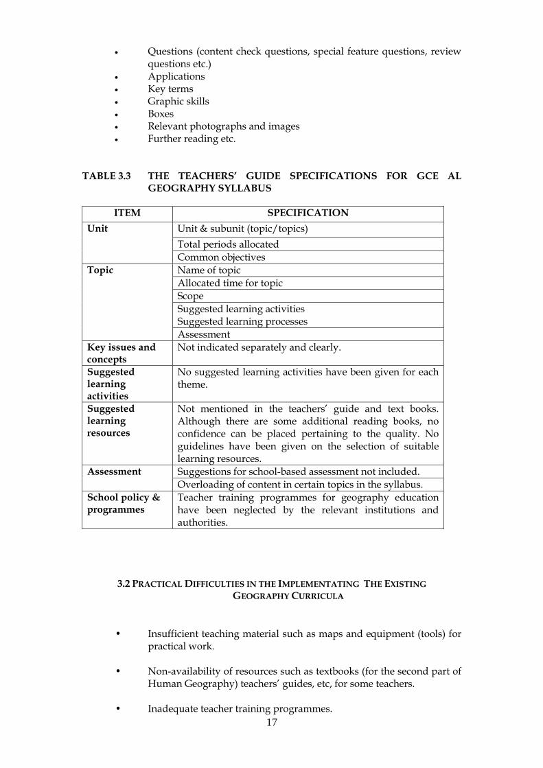
17
Questions (content check questions, special feature questions, review questions etc.)
Applications Key terms Graphic skills Boxes Relevant photographs and images Further reading etc.
TABLE 3.3 THE TEACHERS’ GUIDE SPECIFICATIONS FOR GCE AL
GEOGRAPHY SYLLABUS
ITEM SPECIFICATION
Unit Unit & subunit (topic/topics)
Total periods allocated
Common objectives
Topic Name of topic
Allocated time for topic
Scope
Suggested learning activities Suggested learning processes
Assessment
Key issues and concepts
Not indicated separately and clearly.
Suggested learning activities
No suggested learning activities have been given for each theme.
Suggested learning resources
Not mentioned in the teachers‘ guide and text books. Although there are some additional reading books, no confidence can be placed pertaining to the quality. No guidelines have been given on the selection of suitable learning resources.
Assessment Suggestions for school-based assessment not included.
Overloading of content in certain topics in the syllabus.
School policy & programmes
Teacher training programmes for geography education have been neglected by the relevant institutions and authorities.
3.2 PRACTICAL DIFFICULTIES IN THE IMPLEMENTATING THE EXISTING
GEOGRAPHY CURRICULA
• Insufficient teaching material such as maps and equipment (tools) for practical work.
• Non-availability of resources such as textbooks (for the second part of
Human Geography) teachers‘ guides, etc, for some teachers. • Inadequate teacher training programmes.

18
Lack of coordination among the MoE, NETS, NIE, PEO, Zonal Office
and Universities Failure of SBM (Clashes of time tables/teacher-principal conflict) • Student centered activities are to be restricted because of the rush to
complete the syllabi before final examinations, Therefore, most of the topics are delivered through teacher centered lecture methods.
In order to overcome the weaknesses above, it is necessary to amend, revise
and modernize the existing Geography curricula for GCE (OL) and (AL).

19
4.
IMPROVING THE GEOGRAPHY SUBJECT CURRICULUM
4. 1 MODERNIZIONG THE GEOGRAPHY CURRICULUM Modernization is not a well-known and widely used concept in the context of education (Yrjönsuuri, 2003). When the goal, aim and purpose of the SEMP have been given, one can understand that there are certain internationally well-known principles orienting the tasks and activities of this project. The overall aim is to provide the youth leaving school with skills that are currently lacking. students‘ study activities at school should be developed to include training in such skills and competencies. For this purpose, it is proposed that new Geography curricula for GCE OL and AL, be amended, revised and modernized (Annexes 2 - 8). On the basis of international trends and an analysis of Sri Lankan educational reform and curricula development, the word modernization means at least the following developments (Yrjönsuuri (2003):
(a) equip the students for a changing world, (b) advance the students‘ competency in thinking, (c) foster the students‘ creativity and ability to learn, (d) promote the students‘ ability to choose, (e) practice the students‘ co-operative, competitive and individual
activity skills, (f) provide the students with up-to-date content, (g) balance focus between the breadth and depth of learning, (h) use lessons based on students‘ own responsibility for learning, (i) use assessment as an important tool to promote students‘ learning, (j) train students in self-assessment and peer-assessment as important
activities to promote learning. To develop the students‘ skills, competencies and increase the pass rate, the aforementioned developments are very significant. During the past 30 year period, a decline of the subject occurred due to the weaknesses mentioned in Chapter 3 and lack of coordination among the responsible institutions (Moe, NETS, EPD, NIE, PEO and ZEO). To reach the desired goal and objective of the SEMP, development of teacher education and training are the first and most important. This should be a concurrent activity with the modernized syllabi. Teachers have to promote students‘ studying activities, and teachers have to change not only their actions, but also their own and students‘ thinking about education. Teacher education institutions, ISAs and Teacher Centres should work together for this. It is also essential, however, that school-based development work managed by the principals isinitiated. In many schools, the teachers and principals will not be committed to the change if they do not feel that they themselves have brought it about. Modernization of the curriculum means that textbooks, syllabi, teacher‘s guides, circulars and other documents, prepared to help the teachers in their work, must be developed to support the change. However change requires school-based practical development work. The more the principals and teachers feel able to influence the course of events and the results of actions, the greater becomes their sense of personal responsibility for the change.

20
Yrjönsuuri (2003) further explains, a curriculum reform is a common undertaking of very many people from students up to the government of the country. It affects students‘ and teachers‘ lives in many ways. It includes challenging opportunities for success but also carries the risk of failure. It is never easy to carry through. The participants‘ positive attitudes are of the utmost importance for its success.
For the success of the reform the following attitudes and orientations are highly important:
(a) belief in a common goal, (b) task orientation of all participants, (c) responsibility, (d) trust and empathy, and (e) co-operation.
According to Yrjönsuuri (2003), consensus on a well-defined common goal for educational activities is important so that the different people working for reform do not impede each other‘s work. However, this sometimes happens within topics of the subjects, between the subject area, Arts and Sciences. Therefore, the goal of modernizing the curricula must be clear also to the students‘ parents and the students themselves.
The study of geography can provide a new and existing perspective on the Earth. Of course, there are many other reasons to study geography. Geography is a good way to learn about the Earth‘s varied regions and ways of life. In the study of the Earth, one uses geographer‘s tools, particularly maps and globes. They enable one to locate and compare places anywhere in the world. Therefore, a compulsory geography education is necessary in the secondary level schools of Sri Lanka as an integrated and additional subject to meet the varying requirements and interests of society. Consequently, the following recommendations are made to reach this target.
4.2 RECOMMENDATIONS RELEVANT TO GRADES 10-11 (GCE OL)
Recommendation 1: Consider Geography as a subject (as an interdisciplinary and multidisciplinary subject) offering flexibility as well as variety to meet many requirements and interests of society.
From studying the earth, geographers have learned that its features are always
changing. Some changes take place over millions of years, while others happen in a
day‘s time. Some changes are due to natural causes, and other changes are due to
human activities. The word ―Geography‖ related to these natural and man-made
causes that concern the people, places and time. Accordingly, the Geography
Syllabus links to more specific themes, topics and objectives, which may be used to
determine student-centred programmes (Merrill, 1999). Such a program endeavors
will help students to:
(a) Understand basic geographic concepts. (b) Explain general physical characteristics of the Earth.

21
(c) Explain human patterns that have developed because of the physical environment.
(d) Describe relationships that develop between people and places as physical and cultural features interact.
(e) Summarize how people have changed their physical environment to suit the needs of their cultures and the effect these changes have had on Earth.
(f) Use maps to gather data, recognize physical and human patterns, and interpret the meaning of these patterns and how they relate to people and places.
(g) Use the steps of logical inquiry in their study of geography. (h) Recognize regions and common characteristics that form regions. (i) Gain insight into the ways of life of people from many different
regions and common characteristics that form regions. (j) Increase awareness of the interdependence of cultures throughout the
world.
All these clearly show that the Geography is a subject linking Earth Sciences, Applied
Sciences and Social Sciences. Accordingly, the Geography subject helps one to learn
about the land, water, air and human societies. We should promote the study of
these areas and their impact on the individual and society.
It is proposed that the modernized GCE OL and GCE AL Geography Curricula
should link earth sciences, applied sciences and social sciences around major study
themes and their impact on the individual and society. The major study areas for the
GCE OL (Grades 10-11) include the Physical Environment, Human Resources,
Economic Activities, Sri Lanka (Physical Environment), Sri Lanka (Human
Environment) and Practical Geography. Likewise, the major study areas for the GCE
AL (Grades 12 – 13 focus on propose two papers, Paper 1 – Physical Environment
and Paper II – People and Human Environment instead of three Papers. Paper I
covers six themes and the Paper II covers four themes. Each study theme is further
sub-divided into topics, sub-topics and contents (Annexes 2 - 4 for GCE OL and
Annexes 5 and 8 for GCE AL).
Physical Geography explains and tries to understand the diverse processes and
phenomena in existing nature. Therefore, Climatology, Meteorology, Hydrology,
Pedology, Botany, Ecology, Geology, Geomorphology, Astronomy, Geodecy and
Cartography are integrated with physical geography (Oberlander and Muller, 1987).
In addition, Zoology and Seismology also link with physical geography. Likewise,
Human Geography considers all phases of human social life in relation to the
physical earth. The study of human social life deals with Population Geography,
Economic Geography, Cultural and Social Geography, Urban Geography, Political
Geography, Medical Geography and Historical Geography. Emphasizing both the
physical and the human dimensions, Regional Geography concerns the differences
and similarities among the various regions of the earth. Geography should not be a
part (1/3) of Social Sciences as mentioned in NEC (2003). Two important things will
happen: (1) the NEC‘s expected outcome will not be achieved and the geography
learners become destitute and a lost generation, (2) over 110,000 students who are

22
really interested in studying geography will be deserted. However, trends from 2001-
2003 indicate that students for Geography (additional subject) will be estimated
150,000 by 2007. Therefore, Geography should not be integrated again with Social
Sciences.
Example: When studying natural disasters as a lesson for the topic Dynamic Atmosphere, the teacher should be empowered to select the most appropriate disaster, such as drought, landslide, thunder and lighting, floods etc. compatible with the surroundings where students live, and direct them to make an in-depth study. For this purpose, field visits can be organized and relevant photographs, videos and CD software can be used to show the damage to property and the effects on human lives. Cooperative work and group discussion should also be promoted.
Recommendation 2: Include common core (must learn) subject content in the Geography Subject Curriculum, to provide basic knowledge, skills and attitudes, which enrich students lives and work.
The major weaknesses in the GCE OL Geography Curriculum were described in
Chapter 3. Moreover, SBA has not been introduced to the subject, and the teachers
often adopt the lecture method (dictating notes using chalk and blackboard) to
complete the syllabus content before the term tests and GCE OL examination.
Students are good at book learning, but they are weak when they face practical
situations. Therefore, a written curriculum is needed to help teachers to organize the
course. It should contain the necessary information to keep the course well run and
to provide basic knowledge, such as:
1. The objective of the course - i.e. the tasks and sub-tasks that the
students must learn.
2. The general methods that should be used to teach the students to
reach the various desired objectives.
3. The time and place where the students will learn - i.e. a time table.
4. The methods used to assess the students.
Students‘ skills and attitudes are very significant for all to live in society and in the
world of work. The teachers teach the syllabus following a time table for Term Tests
as well as National Examinations. Teachers often complain that when students finish

23
their learning, they know many facts but they cannot understand and apply them. In
other words, they have the knowledge but they do not have enough skills and
competencies. The reason for this would be that the teachers have not a proper
training and skills to develop the students‘ skills.
Teachers often use the following pattern when they teach skills: (a) describe the skill -
explain what the skill is, why it is important, and when it should be used, and (b)
demonstrate the skill - let the students see an expert (often the teacher) use the skill.
Therefore, theory and practice should be taught inside the classroom together. For
example, consider a teacher teaching students about soil conservation and
management. The following activities would be most useful for the task:
(a) Read a section from a manual on soil, soil conservation and management.
(b) Transfer brief notes to the board.
(c) Make notes in students‘ words on why there is a need to conserve and manage the soil.
(d) Write down the factors affecting in soil erosion.
(e) Make notes in students‘ words on how to conserve and manage the soil.
(f) Use the school garden or any surrounding area to observe soil erosion.
(g) Discuss this particular exercise in relating to each student‘s home garden or surrounding area.
(h) Write down a short assessment and discuss with the students as a group activity.
Thus, the core subject content is essential to develop the basic knowledge, skills and
attitudes of the students.
Recommendation 3: The contents of all categories of the curriculum (basic and essential) should be supported for all categories of learners. Every learner and school is unique.
To achieve good results in the teaching and learning, SBA was introduced by NETS 2001 for the GCE OL and 2003 for the GCE AL (Modernized Guide Book, 2003, NETS). For this purpose, different learning methods have been identified to evaluate the teaching-learning aspects (Perera, 2003). This can be achieved through student-centered activities. Fernando (2003) has designed student-centered activities to cater to all categories of learners; from simple activities (to help slow learners) to more
24
difficult and complex activities (to meet the challenging demands of the higher ability learners).
Recommendation 4: Improve administrative and operational management, and promote research, design and development skills among the students. Greater emphasis should be given to student-centred activities such as investigating, decision making and problem solving. Such creative activities definitely help to develop the employability/working life skills of students.
In developed countries, many geography students select this subject for three reasons (Beaumont, 1997).
1. It is a subject they enjoy and are interested in Geography covers a wide range of issues and locations. The students of school age are much more likely to study topics such as care of the environment, protection of fragile landscapes and the effect of global warming with interest.
2. Breadth and balance
For most students, GCE (OL) Geography will be their last experience of the subject. It will be one of about 10 subjects they will study. Geography makes a contribution as an integrated and additional subject in general education. For the development of employability and working life skills, learners specialize in Science or Commerce subjects. Such learners are also aware of what is going on around them, locally, nationally and internationally. Therefore, a student-centered geography curriculum helps them develop useful skills such as questioning, problem solving and decision making.
3. It can provide jobs.
Students who enjoy the course may decide to specialize in Geography. For a student who follows the vocational route through National Vocational Qualifications or the academic route through A/L and a degree course, Geography can offer interesting employment opportunities. As the world‘s largest industry, the tourist industry provides an obvious outlet for NVQ courses such as Travel and Tourism. Degree courses might lead to employment in such areas as environmental protection or planning. However, it is interesting that the most popular areas of employment for Geography graduates are in administration and operational management, research, design and development. These areas reflect Geography‘s emphasis on investigating, decision-making and problem solving.
Geographers live in the physical environment and society. As mentioned by Fernando (2003) students are involved in some kind of learning pertaining to science, both in and out of school, every day. Geography is also involved in learning both in and out of school every day. In this respect, teachers should be taught geography if they are going to help students:

25
To ask useful, relevant and productive questions.
To investigate things and explore ideas.
To seek and develop explanations that are meaningful and useful to them, with respect to the natural and technological world they confront daily.
To broaden their experience of Society, nature and technology. For this purpose, issue-based and action oriented teaching strategies can be adopted to involve more students. Lessons on the issue of dumping of garbage, the dengue fever, and causes of landslides should be designed for small groups, and/or sometimes for a large group to educate the students on spatial, location, climate change, human impact and environmental issues. Activities should include field investigations, surveys (mapping, measurement and data collection etc.) experiments (rocks and soil), project assignments (group discussions, report writing and presentations, and tasks with problem solving, issue-based and action-oriented approaches. These activities will help to develop communication, manage information, investigation, problem solving, logical and creative thinking, cooperative work and decision making, in addition to the development of cognitive and psychomotor skills in students. Furthermore, all of the above these will help to develop working skills, life skills and employability.
Recommendation 5: Students should be encouraged in more cooperative learning (team work) than individual learning. Group work or collective work among students can help achieve the desired objectives of the student-centered curriculum.
Different categories of students can be seen in a classroom. Therefore, a teacher needs an instinctive knowledge to identify each student. Sometime, teachers spend much time on individual student assessment, and sometime, the teacher neglects the slow learner. Likewise, the teacher may favor high ability students. The geography teacher should encourage appropriate interaction between students. Consequently, the teacher can form several groups of students for a core lesson in the curriculum. For this purpose, the teacher can use learning materials and learning methods to reduce inequality between the students and in the learning situations.
There are three basic ways students can interact with each other in their study activities (Fernando, 2003). They are:
(a) Compete to identify who is ―more superior‖ or ―the best‖ (competitive learning)
(b) Work as individuals towards a goal without paying attention to others
(individualistic learning). (c) Work cooperatively with greater vested interest in each other‘s
learning as well as one‘s own (cooperative learning).
26
Of these three interaction patterns, competition is presently the most dominant,
especially among higher grade students, where one tries to do better than the other
students. Cooperation among students is still rare, due to the competitive
examination system, as students are more concerned with achieving good
examination results.
Forming students, into groups does not necessarily guarantee cooperation among the
students. As mentioned by Fernando (2003), it is only under certain conditions that
cooperative learning may be expected to be more productive. These conditions are:
Positive interdependence
This is the perception that one is linked with others in the group in
such a way that one cannot succeed unless group members help each
other. It promotes a situation in which students work together in
small groups to maximize the learning of all through mutual support.
Face-to-face encouragement interaction
Among students, establishment of positive interdependence is
necessary to maximize the opportunity for students to promote
competitive learning. In this sense, the learning of each group member
can be promoted by helping, assisting, supporting, encouraging and
approving. These are cognitive activities and interpersonal dynamics
that only occur when students get involved in promoting each other‘s
learning. To obtain meaningful face-to-face interaction the size of
groups needs to be small (3-5 students).
Individual accountability and personal responsibility to achieve the
aims of group work
Students learn together so that they can subsequently perform more
effectively as individuals through cooperative learning. To ensure
that each member of the group develops, students are made
individually responsible to carry out do their share of work.
Common ways to structure individual accountability include:
(a) giving an individual test to each student,
(b) randomly selecting students to present their work orally to the
group or to the class,
(c) observing each group and recording the frequency with which
each member contributes to the group‘s work.
Use of relevant interpersonal and social skills
Students must be taught social skills for high quality cooperation and
be motivated to use them. Leadership, decision-making, trust
27
building, communication, and conflict-management skills have to be
taught just as purposefully and precisely as academic skills.
Handing (keeping) out of the group to improve its future
effectiveness
Group processing exists when group members (students) discuss how
well they are achieving their goals and maintain effective working
relationships. Such processing:
(a) enables learning groups to focus on group maintenance,
(b) facilitates the learning of social skills,
(c) ensures that students receive feedback on their participation,
and
(d) reminds students to practice collaborative skills consistently.
Thus, in cooperative learning, the student groups have to be structured and managed
by the teacher. There is a pattern to classroom learning. First, students gain
knowledge, skills, strategies or procedures in a cooperative group. Second, students
apply the knowledge or perform the skills, strategies or procedures alone to
demonstrate their personal mastery. Students learn together and then perform fast
alone.
Due to the modernizing of geography curriculum, teaching-learning activities as well
as teaching learning resources will change. Therefore, new textbooks and teachers‘
guides should be produced. The contents of the proposed syllabi for Grades 10-11
and 12-13, production of TBs and TGs, teacher training and infrastructure facilities,
the students can develop their knowledge more through a cooperative group than
through individual learning.
Recommendation 6: Teaching strategies must ensure greater student participation
(mass learning) in the learning process, empowering students in learning to learn.
Mass teaching procedures reach many students. In mass teaching procedure, the
teacher does not have direct contact, but these methods can used to teach more
effectively.
As mentioned in Recommendation 6, teaching strategies must ensure greater student
participation (mass learning) in the learning process, empowering students in
learning to learn more effectively. Mass teaching procedure can apply to larger
classes with mechanical aids, and less personal contact overwhelm rather than

28
stimulate the student (Archive article, 1959). Consequently, a teacher‘s main duty is
to help people learn and put what they learn into practice. A good teacher finds ways
to provide information and new ideas so that the students will want to learn and will
get satisfaction from learning. The Teacher is the key person in the school system in
the learning process, ensuring maximum participation of students. Therefore,
teachers need to make their work more interesting and appealing to students. For
this purpose, different methods of teaching are necessary to maintain students‘
interest and develop their desire for further learning. This means that teaching
strategies must ensure more student participation in the learning process,
empowering students, encouraging them in learning to learn. Student satisfaction
should be the ultimate outcome of the teacher strategy.
STEP I. Getting the attention of the learner
In classrooms, some students are not always able to learn Geography as with other
subject. The students may be able to hear the words spoken by the teacher, but they
may not really understand them. For example, during the lessons on projections in
Practical Geography, some students will be slow learners. The teacher could begin
the teaching by drowing attention to this problem, helping them realize the various
methods of preparing a flat map of the earth's surface known as projections which
are classified as geometric or analytic, depending on the technique of development
and represent distortions of areas, distances, and direction. For this purpose group
teaching is more effective when it focus on practical examples. For example through
the removing of the peel of an orange, students can understand the connection of
globes to maps (Manson, 1989).
STEP II. Getting the learner's interest.
Students are very keen to look at posters and exhibits. On the basis of this they often
start asking questions. Poster and exhibits are useful aids for teachers about
environmental issues and their influence, conservation, remedial measures and
comparisons between regions etc. Similarly, a topic such as the Solar System and its
features, planet earth and its dynamism, different levels of the tides and their
influence etc. can be supported by such media.
STEP III. Arousing the learner's desire for information.
Many of the students in the class want to know more about certain topics , for
example ―thunder and lighting‖ or ―Savanna Forest‖. If it is possible to use
multimedia facilities (CDs, videos etc.) in such a lesson, the students can see real life
situations. Moreover, in a lesson on savanna vegetation, the student can more readily
understand the physiographic conditions, climatic conditions, distribution and
thickness of the plant species, wildlife etc. in a group-based exercise. Such a method
is useful to ensure student participation in the lesson.

29
STEP IV. Convincing the learners to act.
Students may feel that former lessons were a waste of time as they spent the time
merely note-taking. They are not quite ready to spend time to following the same
procedure. For such lessons, field visits, exhibitions of models, photographs, images
etc. are necessary to convince the students of the more practical aspects.
STEP V - Teaching the learners what to do.
Teachers must know what to do and develop the students‘ skills to achieve objectives
of the teaching strategies. For this purpose, more student participation in the
learning process is required. Learning material and methods are significant to ensure
that students learn to learn.
STEP VI. Making certain that learners receive satisfaction from their action.
The teacher can check student progress in the development of knowledge and skills
through assessing the satisfaction derived by the students. Thus, the geography
teachers have a role in ensuring learners‘ attention and satisfaction.
The teacher should be sensitive to the development of ideas and opinions in
students. Accordingly, the teacher can provide plenty of opportunities for students
to express their ideas, whether in small groups or in the class as a whole. The teacher
should be a facilitator and a guide to students and should also learn along with the
students. All students need guidance and help to link their current experiences to
existing ideas as they attempt to generate meaning.
As a guide and a facilitator the teacher should provide students with numerous
examples and application new concepts, presenting material in several different
ways and formats, and encouraging students to construct tables, flow-charts, draw
inferences and make summaries as they absorb information. Students can be
encouraged to make and check predictions based on their ‗new‘ cognitive
constructions.
The Following should be included in the preparation each unit of the teacher‘s guide:
Objectives of the unit.
Students‘ learning outcomes.
Proposed teaching methodology
Student activities to achieve the student learning outcomes.
Optional activities for higher ability students.
Teaching-learning resources.
Management of allocated teaching time.
Additional notes for the teachers.

30
Suggestions for assessment procedures (National Level Examination
and SBA)
4.3 COMMON RECOMMENDATIONS RELEVANT
TO GRADES 11 - 13 (GCE OL & AL)
Recommendation 7: Assessment procedures should be improved in accordance with
proposed modernized curricula. Possible assessment modalities, such oral tests, written
tests, assignments and project work, should be covered by SBA rather than the National
Examination.
The assessment procedure for GCE OL (revised and modernized) can be improved in
terms of National Level Examination and SBA. The core subject content and activities
during a two year period will be tested at the GCE (OL) National Examination. The
core content as well as students‘ core activities and extended or optional activities
will be evaluated through school-based assessment. Likewise, the final GCE OL
National Examination should consist of two papers:
Paper 1 - Compulsory paper consisting of 50 Multiple Choice Type Questions. This
should be a one hour paper and carrying a maximum of 100 marks.
Paper 2 - Selective paper consisting of 07 Structured Type Questions, out of which,
Question One is a compulsory question on Map reading and Map marking. 25 marks
will be allocated for Map reading and construction and 15 marks for map marking.
Another 3 questions to be selected from the remaining 6 questions and 60 marks (20
marks for each) will be allocated. Finally, at the Grading, total marks for the
Geography subject will be 100.
In relating to the GCE AL, two examination papers proposed instead of the present
three examination papers. For the development of skills and competencies of the
Geography students, practical work is compulsory. Accordingly, maps and globes
are used in geography education as standered tools. Through these means, one can
locate and compare places anywhere in the world. Similarly, using tables and graphs,
it is possible to compare facts and statistics about the people and places we study. In
addition diagrams, photographs and images are also tools for studying geography.
Through these, it is possible to discover facts about the Earth that might be difficult
to understand without the aid of pictures (Manson, 1989). All these emphasize that
every geography student must be able to use maps, tables, graphs, diagrams,
photographs and images in order to understand the world. Therefore, the student
needs to learn map reading, analyzing, understanding and application skills as well
as constructing maps.
In the present assessment systems for the Geography Paper I the skills required are
mainly: drawing and constructing maps, projections, graphs and diagram, Very little
31
attention has been paid to applying this ability after leaving school. Past pass rates
and Geography students in the GCE A/L examination reveal that only 3 – 4% of
geography students enter University. The remainder search employment or enter
Vocational Training Centres and different types of Technical Training Colleges as
well as National Colleges of Education. Therefor, the cartographic knowledge
obtained by standing geography will be useful to all students.
Emphasizing students‘ skill development, competencies and employability and
dealing with the imbalance of the existing geography curriculum, the contents of the
Geography Paper I (Practical Geography) can be incorporated into Paper II and
Paper III. Therefore map reading, analyzing, understanding and application skills
can be evaluated by SBA as well as by the GCE AL National Examination based on
structured questions. Moreover, reading and construction of physical and cultural
features of 1:50000 topographic maps should be included in proposed Geography I
(Physical Environment) and Geography II (People & Human Geography).
The time allocation is 3 (three) hours for one paper, and again Part 1 of Paper 1 will
be a Compulsory Paper consisting of 25 or 50 Multiple Choice questions. This should
be a one hour paper with a maximum 100 marks. Part II of Paper 2 is consisting of 07
structured type of questions, out of which, Question One should be compulsory on
map reading/construction (physical features) 40 marks will be allocated for map
reading and construction. Further 3 questions are to be selected from the remaining 6
questions and 60 marks (20 marks for each) will be allocated to these. The same
process should follow the Paper II, and the compulsory question of Part II of Paper II
should be map reading and construction (cultural features).
The SBA for both levels should be determined and coordinated by a well organized
committee consisting of MoE, NIE, NETS, ISAs, resources persons, geography
teachers and outside experts. At this stage, aassessment modality, teaching-learning
aspects and significant linkages with basic competencies need to be considered
(Annex 12).
Recommendation 8: Learning materials in Geography for OL and AL should enable
students to learn on their own with minimum help from the teacher.
A well-designed, comprehensive textbook is the most important resource for
learning Geography. In addition to text books, practical books, workbooks and other
supplementary reading (additional texts) materials should be made available to
students. A useful textbook should include student activities, investigations,
assignments, extension activities, questions, worked examples, self-check questions,
map marking or map reading, progress tests with answers, guidelines and references
for further studies. None of these are present in the current Geography AL Text
Books.
32
The new O/L student textbooks for Geography should be prepared to suit the
modernized syllabus. The existing map exercise book, published by EPD is of very
low quality. A new map exercise book is needed for the new syllabus
In the 2001 geography examinations, Tamil speaking students made up 16.47% of the
OL and 23.53% of the GCE AL candidates. Therefore, it is a national requirement to
translate all textbooks, syllabi, teachers guides and other relevant information and
material in to Tamil. Likewise, students and teachers should be encouraged to use
the available English language Geography textbooks, and also to gather relevant,
updated, information from other resources such as print media (newspapers,
magazines and periodicals), Internet and e-mail.
The National Institute of Education should be responsible for developing the
curricula. The subject teams of NIE will identify the scope, objectives, content,
methodology and evaluation related to each subject. Expert guidance and advice
must be obtained from experienced practicing teachers, principals, subject specialists
from educational institutions, universities, representatives from the community and
employers.
4.4 COMPUTER ASSISTED LEARNING (CAL)
In education, Computers are used, in developed countries often, as a tool for learning
and teaching . Computer simulations and modeling tools are now available for many
different school subjects providing learning environments to stimulate student
learning. Computer simulation can be a representation of a real world situation,
which a learner can experiment in ways not feasible in the real world.
Recommendation 9: Encourage students and teachers to use computers as an educational
tool for learning and teaching in schools where such opportunities have been provided.
There are over 1000 CLCs to be established during the SEMP I (by 2005) & SEMP II
(proposed for 2005 – 2009). GEP 2 and JICA are also help to increase the CLCs for
many Secondary Schools. The CLCs are to be used for the CAL applications among
the students and teachers. The main attraction of CAL for education is the direct
interaction between the user and software. It is an active, rather than a passive
resource. Computers also provide an instantaneous response to students answers,
and allow students to proceed at their own pace. CAL can be used for programmed
learning, in which each part of content can be treated independently; consequently
there is an opportunity for reinforcement at each stage for the learner. This also helps
the process of learning by discovery, gradually unveiling the key or central concepts
during the learning operation. The use of computer simulations is one facility that
supports this type of learning. The computer may assist the student‘s articulation
and testing of his or her own ideas and hypotheses. The student has the opportunity
not only for the self evaluation, but also to develop his or her own knowledge clear
misconceptions etc (Fernando, 2003).

33
User-friendly CAL packages for example Encarta, Britannica encyclopedia, Nature,
Geography etc. can be used to cover every theme of the modernized Geography
curricula for Grades 10-13. Similarly, the software produced by CEA, Audio Visual
Source on Earth Science, Ecology, Environmental Studies, Geography, Human
Resources and Space Science can serve as exciting educational tools for teachers and
students alike. Some useful packages for geography and human resources (digital
curriculum) in the market are available on following topics:
Climate, landscapes and life: the tropics
Clouds and Patterns of the weather
Exploring Science Series: Exploring Geology
Rivers: Shapers of Earth Landscapes
Rocks and Minerals
Waves, Tides and the Coastal Environment
The solar System: Our Neighbors in Space
School Teacher
The Making of an officer
Learning Geographical Terms
Maps: Symbols and Terms
South Asia
Living Soil
Photosynthesis
the Wetlands.
At oresent CEA has published 10 student-friendly software, which cover a numbers
of topics GCE OL and AL geography syllabi.
Soil erosion and conservation
Your surroundings
Urban environmental problems
Environmental health
Water and its properties
Industrial pollution and environment
Recycling
Pest usage and control
Natural disasters in Sri Lanka
User-friendly software for map work also can be used to construct contour maps,
relief maps, plans, graphs, tables and diagrams. Examples of such software are GIS
such as Arc View, and packages such as Adobe Photoshop.
However, there are certain drawbacks to the implementation of CAL in the school
system. Computers are generally costly to purchase, maintain and update. Some
mechanism must be developed by the school management, in collaboration with the
Zonal Education Authorities, to meet the costs of maintaining and updating the
computers. Furthermore, the authorities of SEMP, GEP 2, JICA, MoE, PEO and

34
NGOs should provide necessary infrastructure to remote and disadvantaged areas
that CAL can also be made available in those areas.
Recommendation 10: Training at Environmental Field Study Centres (EFSCs)
should not be limited only to science students and teachers. The activities should be
extended to geography students as well as other students.
In Sri Lanka, there are 36 Environmental Field Centres (EFCs). Of these, I visited ten
centres with two Environmental Specialists to ascertain the purpose and objectives of
the establishments, the types of activities conducted, and how these might be used in
geography education.
The ten centres visited are located at the northwestern (Madampe Central college
and Kurunegala Maliyadewa Model School), north-central (Kekirawa Central
College and Polonnaruwa Royal College), Uwa (Bibila Central College), southern
(Puwakdandawa Balika Vidyalaya and Balapitiya Siddartha Central College) and
central (Nildandahinna Sri Sumangala MV and Peradeneya Central College)
provinces. These on-site EFSCs are in geographically varied sites (Table 4.1).
All Centres visited (see Table 4.1) differ climatologically, geologically and
geomorphologically. Living organisms (biotic factors) and nonliving variables
(abiotic factors) such as temperature, rainfall, wind etc. have been responsible for the
particular ecosystem in each site. Likewise, these Centers and field study sites clearly
emphasize location, society-land relations and regional variation, all of which are
important topics in geography.
According the circular 2003/21, the EFCs are limited to promoting science education.
The administrative body of the centre is also mainly science-based. Day Programmes
for junior secondary school students (Grades 6-11) and residential programmes for
AL students are given only to science studies. For this purpose, director of Education
(Science and Technology) has sent packages of science equipment to the relevant
centres.
The above centres could so serve geography students in developing their knowledge
and skills relating to core topics such as rocks and minerals, landforms, atmospheric
phenomena, natural vegetation and wildlife, economic activities, natural and cultural
heritage sites, environmental degradation and environmental management etc.
Similarly, the EFCs can help other students to develop their skills, knowledge and
competencies in History and Archaeology, social-cultural and economic changes, as
well as emphasizing socio-economic surveys. Due to lack of proper teacher training
programmes over the past three decades, teching-learning methodologies and
activities are not effective, and EFCs could be used as Resource Centres to undertake
environmental education residential workshops for the geography teachers.

35
TABLE 4.1 VISITED ON-SITE ENVIRONMENTAL FIELD CENTRES
District Name of
school
On-site
Field Centers
Terrain &
landform
Climatic
zone
Puttalam Madampe
MMV
Madampe-
Chilaw lagoon,
mangrove
vegetation
Coastal plain
& wetlands
Dry zone
Kurunegala Maliyadewa
MS
Etugala Urban
Forest
Lower levels
of
intermediate
mid-lands
(dissected)
Intermediate
Zone
Anuradhapura Kekirawa
MMV
Ritigala
Reservation,
Walawawewa,
Nikiniyawa
Low
undulating
Dry Zone
Polonnaruwa Royal College Angamedilla
forest ,
Parakrama
Samudraya
Lower levels
of
intermediate
mid-lands
(dissected)
Dry Zone
Monaragala Bibila
(Wellassa)
Nilgala Forest Steeply
dissected
Dry Zone
Kegalle Kegalu MV Kurulukele
Urban Forest
Intermediate
mid-lands
Wet Zone
Hambantota Beliatta BMV Rekawa
Lagoon
Undulating &
coastal
lowlands,
wetlands)
Dry Zone
Galle Balapitiya
Siddartha
MMV
Maduganga
Islands
Coastal
lowlands &
wetlands
Wet Zone
Nuwara Eliya Nildandahinna
Sri Sumangala
Forest
Resevation
Dissected
highlands
Wet Zone
Kandy Peradeneiya Gannoruwa
Forest and
Mahaweli
River
Transitional
highlands
Wet Zone
36
5.
IMPLEMENTATION OF THE MODERNIZED
CURRICULUM
5.1 NECESSITY OF IMPLEMENTATION
The implementation of the new curriculum will be the responsibility of the Ministry
of Education. Before the implementation procedure of the new curriculum, a number
of steps need to be fulfilled. To complete this procedure, it will take at least two-
years (Annexes 9 and 10). However, the ultimate responsibility belongs to the
teachers. For this purpose, it is the responsibility of the curriculum developers and
other relevant authorities to educate the teachers on the main constituents of the
curriculum, e.g. aims, objectives, methods of teaching, learning resources, assessment
etc.
Due to the failure to educate teachers, delays in the supply of necessary equipment
and resources, and neglect of the academic environment, the whole exercise of
developing the curriculum could fail. During the past 35 years, this has happened to
the Geography Subject in general education of Sri Lanka. This created immense
problems for Geography teachers and geography students who do not reach the
expected levels of achievement.
Recommendation 11: Remedial measures are needed to develop the proper teaching
training programmes, minimize the mismanagement in the school system.
The following are some of the negative aspects in the implementation of the
Geography Subject Social Sciences, as an additional subject in Grades 10-11, and as a
core subject in Grades 12-13:
In-service training in Geography is completely inadequate and
neglected. In-service advisors are sometimes not qualified in the
subject.
The teachers are not adequately trained and are not aware of the aims,
and objectives, methods of teaching, learning resources and
assessment of the curriculum. As a result, teachers determine their
own ways and means to educate their students.
The numbers in a Geography class are not large. In most schools, this
varies between 5 – 30 students. This size is suitable for teachers to

37
organize activity based teaching methods, but 95% of the school
system still follows the dictation (taking notes) approach to teaching.
There is currently no proper effective monitoring system to
investigate feedback on the teachers performance and student‘
satisfaction.
Basic resources such as globes, topographic maps, world maps, school
atlases, measuring instruments, etc., are very sparsely distributed
among rural and disadvantaged schools. Additionally, in that areas
trained IASs and grassroots level teachers are minimal.
Some material and financial support have been provided to principals in order to
support the delivery of the National level Geography Syllabus, but A-level teachers
often do not teach using the material given, because of lack of awareness and
knowledge of them and due to the lack of co ordinations among the PMoE, ZEO and
the debility of SBM. Some teachers currently guess the A-level questions that will
appear in the forthcoming examination, and forget their teaching accordingly. Many
students will then get ―A‖ or ―B‖ grades, but no development of skills and
competencies to such students. Teachers should realize that partial coverage of the
syllabus many influence the progress of students after they leave school.
To improve the quality of the A-level geography teachers and their teaching, it will
be necessary to identify a group of resource persons from experienced teachers and
train them appropriately. Such training is needed to towards based on pedagogic
requirements for changing the attitudes and aptitudes of the teachers. The in-service
trained teacher can identify social and physical differences of students and develop
the skills and competencies as well as the guidance and counseling of the students.
Additionally, such a group can be used to educate and monitor the other teachers.
Geography is an additional subject for the O-level since 2001. Before this time,
Geography was integrated into Social Studies. As a single subject, Geography will be
introduced again to the Junior Secondary School Curriculum (Grades 7-9) from 2005,
and the services of In-service Advisers are required to support this. The ISAs will be
required to assign their entire time to the professional development of their
colleagues.
Recommendation 12: Secondary School Geography teachers should be involved in
giving the students assessment feedback frequently and guiding the students in self-
assessment and peer-assessment.
In self-assessment, each trainee assesses his or her own performance. At the
beginning of a new course, the students may not yet have adequate knowledge to

38
assess themselves. However, after they have qualified to a certain extent, they should
be able to work with very little supervision. This is good practice because later on
they also have to assess their own performance in their learning.
In self-assessment, students need clear guidelines on what standards are required.
They must also be given a very clear idea of the tasks. It should be noted that the aim
of self-assessment is to learn and not to score points. There is thus no problem of
cheating. An alternative to self-assessment is peer-assessment. This means that the
students assess each other. It is a very good method of helping trainees to learn.
The teacher can give written instructions on an assessment. One of the students then
tries to do the lesson while the other one watches and comments. At the end, the
students change roles and the second student does the job while being watched by
the first one. This method is very useful, for example for teaching about rice
production, working on sand mining or other practical skills.
5.2 Teachers Capacity Building Measures
Since the education reform in 1972, teacher training for the Geography Subject has
been completely neglected. Since the integration of Geography into Social Studies,
teacher training in Geography was gradually decreased. The reasons for this were
annual retirement of trained teachers, abatement of new recruitments for geography
teaching and, no regular in-service or other training conducted by the NIE or MoE.
Moreover, geography was neither compulsory nor an additional course in the
National Colleges of Education. A small Geography component can be seen in the
Social Studies course content at Ruwanpura NCE, but this is not sufficient to produce
geography teachers.
It is necessary to revise the teacher training program drastically at NCEs and should
be introduced student-centred activity-based, and skill and competency
development based courses as early as possible for the Geography Subject. For this
purpose, a very strong coordination is required between MoE, NIE and NCEs. At
present, the MoE has taken a policy dissection to introduce three subjects:
Geography, History and Civics (Civics Education) replacing the current Social
Studies subject discipline. Therefore, this gap need to be will filled considering as a
national requirement.
Recommendation 13: A secondary School teacher of Geography should be involved in
some activities to educate and guide the students to develop their skills.

39
A secondary School teacher of Geography should be involved in teaching, guiding
and counseling of many activities to educate and develop their skills and
competencies. Accordingly, he or she:
prepares and gives lessons in Geography. Usually plans lessons
according to a syllabus.
uses textbooks, practical work, discussions and field trips as teaching
aids. Also uses maps, diagrams and other visual aids to illustrate
lessons.
prepares materials such as handouts and tests.
organises and directs study, but also encourages pupils to discover
facts for themselves. Gives individual help to pupils as required.
sets projects, assignments, tests and exams. Carries out continuous
assessment, evaluate this and writes reports on progress.
prepares students for examinations.
maintains discipline in the classroom.
prepares for and attends parent-teacher evenings and staff meetings.
keeps a register of pupils and is usually involved in other general
administration.
supervises out-of-hours activities such as field trips, social events and
other skill development activities.
Thus, secondary school teachers of Geography work mainly in the classroom. They
work away from school when on field trips and educational visits. They mostly work
with young students, although they also deal with colleagues and parents. School
hours are 8.00 am to 2.00 pm. Additional time spent on preparation, marking and
paperwork. Geography teachers are also required to attend out-of-hours activities
such as parent-teacher meetings. But in Sri Lanka, there is no such approach to
teaching may seem difficult to the teacher. It requires a different kind of planning
and organization than that required in traditional classroom teaching. It may seem
even more difficult where there is a scarcity of teaching materials, for example maps,
globes, example kits etc., and resources for field trips as well as proper teacher
training.
Recommendation 14: Ongoing teacher training programs should be developed to improve
the quality and professional slandered of geography teachers. Through this, the trained
teacher will be able to: (a) use different teaching strategies to promote learning and, (b)
evaluate students through appropriate school based assessment procedures.
With the modernization of the Geography Curriculum for Grades 10-13, a complete
training programme for resource persons and teachers, who are working in
Geography education has to be commenced and carried out by the NIE, in

40
collaboration with MoE, Universities and other stakeholders. Therefore, it is essential
that a series of activity-based seminars and residential workshops are organized.
Teacher training programmes for In-service Advisors and A/L Resource Persons
should include seminars/workshops from time to time. Accordingly:
1. A compulsory one week residential workshop/seminar should be
held, where the participants are educated in the various aspects of the
modernized O/L and A/L geography curricula. This workshop
should focus on::
the content of the syllabi, teaching & learning methodologies,
student activities, assessment modalities and outcomes
School based assessment procedures (SBA)
the preparation of in-service materials to improve the quality
of the students
facilities those are available for students and teachers,
example. EFSCs, CLCs etc.
It is highly necessary to instruct the participants to cover the two- year course
of the O/L and A/L syllabi.
2. A two-day compulsory workshop should be held in every school term
to review, discuss and modify teaching and learning methodologies,
student activities, assessment modalities, outcomes etc., to prepare for
the forthcoming school term.
3. Compulsory training programmes for O/L and A/L geography
teachers are to be carried out. At these workshops/seminars to be
held in school vacations:
curriculum components designed for that term
objectives of the themes to be taught that term
learning-teaching processes and methodologies
use of teaching aids/materials
student learning outcomes (skill development and competencies)
assessment, including SBA
facilities that are available for students and teachers, example EFSCs,
CLCs etc.
For this purpose, a one week training programme is required. At least six such
workshops are recommended island wide to cover the two-year Geography course of
the syllabi. Apart from the above, a series of two-day compulsory
seminars/workshops preferably during week-ends should be organized to review,
discuss and modify the teaching methods as well as student-centred activities. These
training programs should include preparation of teaching manuals and materials,
41
use of cost effective resources for practical student activities, as well as procedures
for SBA. Furthermore, in these training programmes, it is necessary to discuss the
issues, problems and constraints to be faced. Among the constraints are obtaining of
teaching material from the school management2, taking students outside the school
for fieldwork, improper arrangement of timetables by the school management.
For O/L teachers, these workshops/seminars can be organized in the Zones, and for
A/L teachers, District-wise under the direction of NIE curriculum experts.
In addition to the training of ISAs and A/L Resource Persons for both levels the
modernized Geography curricula, a number of additional awareness programmes
should be conducted by NIE to educate the other stakeholders:
(a) Officers of the MoE, NETS and EPD
(b) Principals/directors and Lecturers of Teachers Colleges and Colleges
of Education.
(c) Managers of Teachers Centres
(d) Zonal and District Education Officers
(e) Principals of Schools
(f) School assistants in the principal‘s office
(g) Parents, and the public.
5.3 Facilities and required Resources
The Geography curriculum involves a special way of looking at the planet Earth and
its people. It looks at relationships between groups of people, between places, and
between people and places. To support this facilities and equipment are needed for
student-centred learning, skill development and for teachers‘ knowledge. The
curriculum developers must consider the whole that teaching-learning process,
learning activities, etc., other than the teaching aids are necessary for specific topics.
For successful geography education programme in secondary education in Sri Lanka,
it is necessary to educate teachers on cartographic techniques. At present, there is no
separate unit to complete this requirement at NCEs or at NIE. Although, graduate
teachers had followed a cartographic course at their University degree programme
(for the geography subject), they have no been given any opportunity a minimum
chance to develop their practical application skills after graduation.
3 In many schools, it is very difficult to obtain globes, maps etc. from the principal’s office for the
allocated time of the timetable. Most of the materials that are needed to geography teacher cannot bring
to the classroom due to this restriction.
42
Recommendations 15: Well-equipped cartographic laboratory should be established to
educate secondary school teachers
Likewise, there are two Education Faculties at Colombo University and Open
University and an Education Department at Peradeniya University, but geography as
a subject is not offered in these places. Therefore, it is not possible to educate non-
graduate geography teachers at the universities. Hence, a well-equipped
cartographic unit should be established at NIE to train such teachers and for further
training of graduate geography teachers. This unit should be equipped by GIS
facilities (ArcView user friendly packages), aerial photographs, stereoscopes (pockets
and mirror), topographic maps, globes, thematic maps, measuring tapes, compasses
etc.
Recommendations 16: Existing Geography syllabus in B.Ed. Degree Programme at
NIE should be revised to train teachers in order to meet goals and objectives of the
modernized Geography curriculum and to develop the Geography education.
At present, a three-year degree programme (B.Ed) for non-graduate teachers is
conducting at NIE. To complete this programme, students need to take three
subjects. Although, Geography appears as one subject in the subject list, the syllabi
should be revised and recognized a General Degree level of the Universities. For this
purpose, existing syllabi in internal and external degree programmes take into
consideration and necessary assistance and guidance should be obtained from the
Universities.
For first year in this degree programme, all units should be related to education,
including education psychology, counseling and carrier guidance, the concepts of
skill and competencies development etc. A student, who takes Geography as a
subject from second year, three compulsory papers should be introduced, namely
Physical Geography, Human Geography and Cartography, and again for the third
year three papers should be introduced relating to physical and human geography,
example Physical Geography and development, Economic Geography, Application
geography education for skill and competencies development etc. Thus, this B.Ed.
degree programme will help cover the Grades 10-13 syllabi and to promote
modernized Geography curriculum (present study under the SEMP 1).
As emphasized in Recommendations 11, Environmental Field Studies Centres can
use as resource centres teaching and learning of geography. These centres provide
facilities for the students to study environmental phenomena as well as the socio-
cultural environment in surrounding areas. These centres can also be used to conduct
environmental awareness programmes for geography teaches at Zonal Level. As
resource centres, they also provide opportunities for students and teachers to work
43
with scientists, experts and others to promote encourage the developmental
supportive and enriched teaching-learning environment that will foster the students
skills and competencies in investigation, decision making and problem solving.
Recommendations 17: A common (mini) laboratory is needed to promote Geography
Education. Use of a laboratory as a resource for teachers and learning geography, it
will enhance practical application knowledge and skills.
The Grade 10-11 curriculum will comprise eight subjects including Science,
Geography and Design Technology since 2005. The subject Design Technology
consists of eight disciplines including Agriculture and Food Technology and Home
Economics. The subject of Physical Geography is concerned with Atmosphere,
Hydrosphere, Lithosphere and Biosphere (Figure 1.1). To understand the complexity
and concepts in physical geographical topics and sub topics of the Theme 1 or and
Theme 4 of the modernized curriculum helps students to develop their practical
knowledge and skills. A mini Practical Laboratory would support this. At present,
many schools possess science laboratories. However, the use of school science
laboratory as a resource for learning science, geography students and teachers have
not permitted to use for their lessons. Therefore, it should be expanding to
geography education, because these students are learning science based geography
themes in Grade 10-11. Consequently, a common mini laboratory is recommended
with basic equipment for science, geography and agriculture students, which could
be also be used to promote environmental education at secondary school level in Sri
Lanka. Such a laboratory will help students to:
understand complex and abstract concepts in science
participate in actual investigations, employing and developing skills
as an essential component of learning science as inquiry
ideentify, diagnose and rectify their misunderstandings
enjoy activities and practical work, when they are offered and given a
chance to meaningful and non-trivial experiences, and they become
motivated and interested in learning geography and science-based
subjects.
Taking into consideration the above requirement, it is essential that a common school
laboratory should be supplied with all the requisite facilities, such as space,
furniture, water, gas, electricity, laboratory equipment, chemicals, and storage as
well as a laboratory technician. The attached list of equipment, which is prepared for
the Environmental Education Specialist (Hamari 2004, Annex 5.1) is suitable for such
a laboratory. The resource laboratory could be used by geography, science and
agriculture students. Preparation of equipment, apparatus and chemicals in time for
the practical class, collecting, checking and storing after the practical lessons, and
cleaning and maintenance of the equipment and the laboratory would be the main
responsibilities of the laboratory technician.

44
In the proposed Grade 12-13 Geography syllabus, there are also practical work and
application have been included. The modernized Grade 12-13 geography syllabus
(Geography 1 – Physical Geography) includes five themes, namely; Planet Earth,
Landforms, Rocks and Soils, Weather & Climate, Hydrosphere and Global
Ecosystems require laboratory and practical work (Annex 5, see the extended
contents).
5.4 Institutional Development
In order to attain the goals of SEMP, we must improve the O/L and A/L student
skills, competencies and increase the pass rates. For this purpose, well-organized
coordination is required among the institutions of MoE, NIE, NETS and EPD, and
changes to the evaluation/assessment system are necessary.
Recommendation 18: The improvement of the Geography curricula requires the
training of geography education specialist (who are not teachers) in respective disciplines
with sound educational background. These specialists should be competent and confident
enough to guide and lead the curriculum development team of the geography subject.
.
Responsible Institution of the quality improvement for the modernized Geography
curricula is NIE. Accordingly, the design and development of the Geography syllabi,
preparation of teacher‘s guides and resource materials for teaching-learning process,
organizing and conducting teacher training programmes and other capacity building
measures should be developed by the NIE officers. At present, there are staff at NIE
for Geography (two for Sinhala medium and one for Tamil medium). This is not
sufficient to deal with the additional workload on top of other activities.
The same NIE staffs (three persons) cover the Geography, History and Civics
Education curricula, and organize the different seminars/workshops. In addition to
the above, these officers hold in and outdoors meetings, seminar and workshops. The
number of officers should be increased and existing officers should be trained
further. The training of the present officers is mainly related to Social Studies and
does not provide sufficient training in Geography. From 2005, the geography will be
taught from Grades 7-13. This will be a good for the subject, but means that
coordination is required among all of the relevant institutions.
With the improvement of the Geography subject curricula, it is very important that
the geography education specialist to train in order to continue respective
disciplines. These specialists should be competent and confident enough to guide
and lead the geography curriculum development team of the geography subject. For

45
the training academic and professional level specialist or specialists, following
proposals are made for NIE.
Recruit two more Geography graduates (Special Degree) with first or
second-class upper-division in the respective disciplines. Practicing
teachers are also preferred.
Provide the staff with the opportunity to complete a Masters Degree
(two year) in Geography education at a respectable foreign university
within one year of recruitment.
After serving a three-year period, an opportunity should be given to
at least one officer to read for a Doctorate in Geography Education.
Reading M.Sc./Ph.D. Degree will produce specialists with subject knowledge as well
as the professional competency.
Recommendation 19. Coordination within the MoE (responsible officers in the various
branches), and between MoE and NEC, NIE, EPD, NCE, PEO and ZEO are precisely
weak. Without their strengthen coordination, the modernized subjects curricula are
unable to implement, evaluate and monitor.
Modernizing curricula, implementing and monitoring their delivery are not
responsibility of a single institution. Coordination is required among institutions of
MoE, NIE, NETS and EPD. The evaluation/assessment system will need to be
changed the requirement of the modernized curriculum. Presently, the coordination
among responsible officers in the various branches of MoE, and between MoE and
NEC, NIE, EPD, NCE, PEO and ZEO are precisely appear as individual effort.
It is clear that the delays and time wasting of preparation of Teachers‘ Guide,
Textbooks for the geography education are weak. Similarly, time-consuming
distribution of textbooks and other material, financial waste and constraints, lack of
communication among the divisions/units of a same institutions and between the
Institutions and the MoE are significant. Without strengthened coordination and
commitment, the modernized geography curriculum cannot be implemented,
evaluate and monitored.
5.5 Textbooks
According to article in the ―Archive Article, Encarta‖, 2004, more and more textbooks
in Geography are produced worldwide. In response to very active demand, for more

46
geography in curricula of schools, the output of geography textbooks and references
was likely to surpass any previous record. These textbooks are used as learning
instruments used in schools and colleges for the successful completion of a learning
activity, which incorporates all the essential basic content of a particular course.
Thus, more and more textbooks are produced worldwide, but not in Sri Lanka, and
that Sri Lanka needs more Geography textbook for the modernized curriculum. In a
textbook, subject matter pertaining to the course is presented in a systematically
organized form in order to facilitate the learner, example.
Recommendation 20: To improve quality of learning, professionals should be handled
writing and printing of textbooks. Institutional capacity for developing and publishing
textbooks should also be improved.
A textbook contains the assigned text for a course of study and sometimes, it
represents the only teaching resource. At present, there is no generally accepted
format for the Geography textbooks in Sri Lanka. However, mathematics textbooks
are prepared with three distinctive features (Fernando, 2003).
1. Presentation of subject matter.
2. Worked example
3. Sets of exercises.
A student-centered textbook, should include chapter objectives, skill objectives,
activities (teaching and learning), review and evaluation as a minimum.
There is no textbook for the O/L additional Geography subject. The teacher Guide
for this syllabus was published in May 2004, after three and half years. Where A/L
Geography is concerned Papers l, ll and lll have Teachers‘ Guides. However,
textbooks complete only paper l, ll and a part of paper lll.
In Sri Lanka textbooks given free to students, have been prepared for grades 10 and
11 but not for grades 12 and 13. Though the preparation of the grades 10 and 11
textbooks has to be appreciated, they are not of an acceptable standard in their
preparation. It is not my purpose here to highlight these deficits, but some points are
very significant. In recent times, textbook production is not a national requirement, it
is a business task.
To produce teachers‘ guides and textbooks, it is necessary to consider the syllabi as
legal documents. Draft Syllabi for Grades 7-9 had not appeared as legal documents
by May 2004, but textbooks for Grade 7 are in preparation under the direction of EPD
without the guidelines of the NIE. Though the O/L syllabus is a legal document, the
relevant authorities, especially EPD has been incapable of producing textbooks with
NIE coordination by 2004.

47
Preparation of guidelines for textbooks for both O/Level and A/Level Geography is
an effort of NIE. The following are some of guidelines, which will be used in the
pr4eparation of Geography textbooks. They were compiled after careful study of the
strengths and weaknesses of the existing Geography Textbooks for Grades 12-13 and
other selected subjects for Grades 10-11 and foreign textbooks:
The content given in the textbook should conform to the educational
aims, aims of learning geography and the intended Geography
syllabus.
It should be written, in an accepted sequential order, as a guide to
taught and supplement material.
The style used should conform to those accepted in textbook writing
and should be maintained throughout the book. Writers should
remember that the style used in textbook writing is different from that
used in a workbook, story or a novel.
Geographical terminology should be in keeping with the respective
age groups. It should be simple so as not to be a hindrance to
students‘ learning. The key words used should be such that unfamiliar
words are introduced only if absolutely necessary. When introduced
these they should be clearly then and there.
When terminology is introduced the same term should be used
throughout even when an equivalent term is available but used in a
different context.
In geography textbooks, the use of tools such as maps, tables, graphs,
diagrams, photographs, visual images and tables are essential and
clear, relevant, and appropriately sized and located. For example;
Geography – An Integrated Approach, David Waugh, 1994, and
World Geography, People and Places – Merrill, Teacher Annotated
Edition, 1989. Worked examples are an indispensable component of
geography textbooks. It is important that such examples are so
selected that they are the best available, simple and chosen from
current and real life situations.
Exercises, which are also an essential aspect of Geography textbooks,
should be such that they are carefully selected, graded and presented
in order of difficulty. Challenging problems may be given for the
benefit of higher ability pupils, but they should be distinguished in
some manner. In the current A/L Geography text books, there are no
chapter objectives, content checks, graphical reinforcements,

48
remembering and understanding of facts, thinking critically and
creatively, reviewing vocabulary etc.
The size (length, breadth and thickness) of the textbook should be
predetermined in relation to the age of the children and the Grade
where it is used, but the textbook writing authorities should not limit
the number of pages.
The Quality of printing of the Geography textbook is also very significant. The
quality of the paper; accuracy of symbols and colors on geographic tools; print size
and the binding, and even the cover page that makes the book attractive, readable,
usable (durable) and pleasing to the eye are factors to be considered.

49
6.
CAREER DEVELOPMENT AND EMPLOYABILITY
Students may decide to specialize in Geography, after the learning school through
either both the vocational route, through NVQ, or the academic route through A
levels and degree. Geography can offer interesting employment opportunities
(Beaumont, 1987). However, skills development is necessary for persons who are
preparing to enter the labor force or who need training or retraining in the
technology of their occupation.
Recommendation 21: Counseling and career guidance should be monitored to
students and school leavers, who are preparing to enter the labor force or who need
training or retraining in the technology of their occupation.
European Commission Development Cooperation Policy in the run-up to 2000
reveals that technical education and vocational training (TEVT) are essential to create
qualified manpower needed by all sectors of the economy. In addition, TEVT offers
an alternative for purely academic post-secondary studies and provides a route to
self-employment in both the formal and the informal labour markets.
Relating the support given in this sub-component to the needs of the labour market
is particularly important as unit cost of producing a person TEVT is normally low.
For the same reason, it is essential to ensure that the kinds of skills for which training
is being offered are tailored to the actual needs of employers. Support at the
NDF/ADB, World Bank, JICA, NORAD etc. in this area must, therefore, be
integrated into a long term strategy for technical manpower development in Sri
Lanka, which will be sustainable through support of administration.
To train people to meet the needs of industry, agriculture, tourism and other users of
technical skills is essential when planning curricula. Also, in-service training, such as
apprenticeship schemes, upgrading programmes and extension courses should be
given an equal emphasis to the pre-service training that are more commonly
supported .
In view of the need to ensure that instructors in these areas have both professional
qualifications and practical employment experience. Support should be made
available for industry-based, agriculture-based and services-based instructor training
and for the in-service training and upgrading the existing instructor cadre. This is
again very useful and helpful in developing the life skills and competencies of the
school leavers.

50
The impact of technology on occupations, the tendency of employers to demand
higher educational backgrounds, and the need for employees with specialized
training have made vocational preparation imperative (Brickman, 2004). Various
standardized tests and inventories have been developed to measure skills, aptitudes,
interests, and other abilities and traits. In addition to school records, job-shadowing
techniques, computerized programs, and audiovisuals are also used to assist
students with occupational selection. For this purpose, career counseling and
guidance are very significant. Through career counseling and guidance, a person is
better equipped to make occupational plans after determining his or her own
characteristics in relation to the requirements of various occupations.
Fruehling (2004) emphasizes that in public schools, guidance programs should be are
organized as a series of services. One of the services is academic planning.
Counselors can assist students to select courses, and programs are also designed to
help students who have academic difficulties. Student appraisal is another
counseling function. Standardized tests are administered to assist in appropriate
academic students of placements, assessing academic achievements, identify
individual aptitudes, exploring vocational interests, and examining personal
characteristics. Also, tests are used to identify gifted students and those with special
learning problems.
Other counseling services include career-development programs to foster awareness
of career alternatives and training in actual employment skills, as well as the
acquisition and dissemination of related information. Counselors coordinate with
teachers, administrators, and families in making effort to help resolve specific
students‘ problems. Students can be referred to the physiotherapists and doctors as
where there is a necessity. In colleges and universities, administrative officers such as
student affairs, admissions, financial aid, housing, student health, and placement
etc., provide guidance services. College counseling centers assist students with
academic, vocational, or personal problems.
The proposed improved and modernized Geography curricula (grades 10 – 13)
include (activity based) themes to provide school leavers, especially after the A/L,
the skills and attitudes required to meet the demands of a competitive job market. By
grade 12-13, students will understand the reciprocal relationship between the
activities of man and the environment. The proposed Geography course helps
students to develop useful skills in questioning, problem solving and decision-
making. Additionally counseling and career-guidance programmes are required to
help solve academic, vocational, or personal problems.
Recommendation 22: Awareness programes should be conducted to change the
negative attitude of policy makers and decision makers. It is required to develop the
skills and attitudes to meet demands of the competitive labour market.

51
One SEMP goal is ―to provide youth leaving schooling after A/L examination, the
skills and predispositions that are required to meet the demands for the competitive
labour market‖. Accordingly, the modernized Geography curricula for grades 10-11
provide students the following advantages:
self confidence for students to develop skills for their own job
opportunities.
skills for students entering the job market.
examination skills for students
vocational opportunities for the less qualified academic students
Additionally, the following aims should be addressed.
possible job opportunities for school leavers
- self employment opportunities
- entry to private sector (general job opportunities)
obtain a qualifications to admit
- Teacher Training Colleges
- National Colleges of Education
- Technical Colleges
- Professional Institutes
- Computer Based Institutions
obtain qualifications to enter the Universities (local and foreign)
With proper counseling and career-guidance, school leavers who study geography
can fit into one of above three areas. On completion of a technical training, a
vocational training or a degree programme there is a possibility of paining
employment in the following areas:
Natural resource management
Urban and regional planning
Human Resources Development
Human settlement planning
Rural Development & Poverty alleviation
Environmental planning
Defense
Education and educational institutions
Provincial Council and Municipalities etc.
Tourism and recreation
NGOs etc. (local and international)
As an example, the tourism industry which is one of the largest industries in world,
provides an obvious outlet for NV holders in fields such as Travel and Tourism.
Degree courses might lead to employment in areas such as environmental protection,

52
planning etc. However, it is interesting to note that the most popular areas of
employment for Geography graduates are in administration and operational
management together with research, design and development. All of these areas
reflect and emphasis on investigation, decision making, problem solving which are
qualities in Geography. To reach this level in Sri Lanka, it is necessary a awareness of
programme in order to change and promote the attitudes of policy makers and
decision makers.

53
7.
SUMMARY AND RECOMMENDATIONS
7.1 Recommendations relevant to grades 10-11 (GCE OL)
Recommendation 1: Consider Geography as subject (as an interdisciplinary and
multidisciplinary subject) offering flexibility as well as variety to meet many
requirements and interests of society.
Recommendation 2: Include common core (must learn) subject content in the
Geography Subject Curriculum, to provide basic knowledge, skills and attitudes, which
enrich students to lives and work.
Recommendation 3: The contents of all categories of the curriculum (basic and
essential) should be supported for all categories of learner. Every learner and school is
unique.
Recommendation 4: Improve administrative and operational management, and
promote research, design and development skills among the students. Greater emphasis
should be given to student-centred activities such as investigating, decision making
and problem solving. Such creative activities definitely help to develop the
employability/working life skills of students.
Recommendation 5: Students should be encouraged in more cooperative learning
(team work) than individual learning. Group work or collective work among students
can help achieve the desired objectives of the student-centered curriculum.
Recommendation 6: Teaching strategies must ensure greater student participation
(mass learning) in the learning process, empowering students, learning to learn. Mass
teaching procedures reach many students. In mass teaching procedure, the teacher does
not have direct contact, but these methods can used to teach effectively.
7.2 Common recommendations relevant to grades 10-13 (GCE OL & AL)
Recommendation 7: Assessment procedures should be improved in accordance with
proposed modernized curricula. Possible assessment modalities, such as oral tests,
written tests, assignments and project work, should be covered by SBA rather than the
National Examination.
54
Recommendation 8: Learning materials in Geography for OL and AL should enable
students to learn on their own with minimum help from the teacher.
Recommendation 9: Encourage students and teachers to use computers as an
educational tool for learning and teaching in schools where such opportunities have
been provided.
Recommendation 10: Training at Environmental Field Study Centres (EFCs)
should not be limited only to science students and teachers. such activities should be
extended to geography students as well as other students.
7.3 Recommendations for modernized Geography curricula
Recommendation 11: Remedial measures are needed to develop the proper teacher
training programmes, minimize the mismanagement in the school system.
Recommendation 12: Secondary School Geography teachers should be involved in
giving the students assessment feedback frequently and guiding the students in self-
assessment and peer-assessment.
Recommendation 13: A secondary School teacher of Geography should be involved in
activities to educate and guide the students to develop their skills.
Recommendation 14: Ongoing teacher training programs should be developed to
improve the quality and professional standered of geography teachers. Through this,
the trained teacher will be able to: (a) use different teaching strategies to promote
learning and, (b) evaluate students through appropriate school-based assessment
procedures.
Recommendation 15: Well-equipped cartographic laboratory should be established to
educate secondary school teachers
Recommendation 16: Existing Geography syllabus in B.Ed. Degree Programme at
NIE should be revised to train teachers in order to meet goals and objectives of the
modernized Geography curriculum and to develop the Geography education.
Recommendation 17: A common (mini) laboratory is needed to promote Geography
Education. Use of a laboratory as a resource for teachers and learning geography, it
will enhance practical application knowledge and skills.

55
Recommendation 18: The improvement of the Geography curricula requires the
training of geography education specialist (who is not teachers) in respective
disciplines with sound educational background. These specialists should be competent
and confident enough to guide and lead the curriculum development team of the
geography subject.
Recommendation 19. Coordination within the MoE (responsible officers in the
various branches), and between MoE and NEC, NIE, EPD, NCE, PEO and ZEO is
weak. Without their strengthened coordination, the modernized subjects curricula will
not be implemented, monitored and evaluated.
Recommendation 20: To improve quality of learning, professionals should be
responsible for writing and printing of textbooks. Institutional capacity for developing
and publishing textbooks should also be improved.
7.4 Recommendations for carrier development
Recommendation 21: Counseling and career guidance should be promoted to
students and school leavers who are preparing to enter the labor force or who need
training or retraining in the technology of their occupation.
Recommendation 22: Awareness programmes should be conducted to change the
negative attitude of policy makers and decision makers. It is required to develop the
skills and attitudes to meet the demands of the competitive labour market.

56
REFERENCES
Abbatt F.R. (1992). Teaching for better learning (WHO). Second edition, World Health
Organization, Geneva, 1992
Beaumont, A; Hetrringto, J; Whetley, R. (1997). World Geography (Core Book), David
Lambert (Editor), Cambridge University Press 1997.
Brickman, William W.(2004). Vocational Education. Encarta Encyclopedia, Microsoft
Corporation. 2004.
Collier's Year Book, (1938). Archives Article, Geography, Encarta Encyclopedia, 2004
Collier's Year Book, (1940). Archives Article, Geography, Encarta Encyclopedia, 2004
Collier's Year Book, (1959). Archives Article, Geography, Encarta Encyclopedia, 2004
Comings, John and Kahler, David (1984). Literacy Handbook (Peace Corps). Peace
Corps of the United States of America. Information Collection and Exchange.
Manual M0021,October 1984.
ECD (1996). Strategies III, Education (sub-section), Communication from the
commission of 26 september 1994 In. European Commission Development
cooperation policy in the run-up to 2000. Luxembourg: Office for Official
Publications of the European Communities, 1996, ISBN 92-827-6487-7. ECSC-
EC-EAEC, Brussels - Luxembourg, 1996.
Fernando,A.D. (2003). Science Subjects (Quality Improvement). Secondary Education
Modernization Project (SEMP) (ADB / NDF NO: 356).
Husen, Torsten and Postlethwaite, T. Neville (1995. Core Curriculm. in The International
Encyclophedia of Education (Second Edition).
Manson, Gary, (1989). World Geography (Chapter 5). Macmillan/McGraw-Hill,
Westervill, OH.
Merrill Publishing Company (1999). Merrill World Geography, peoples and Places
(Teacher Annotated Edition). MPC, Columbus, Ohio.
NETS, (2003). Modernized Guide Book, 2003. Teaching and learning aspects of SBA.
Introduced by NETS 2001 for the G.C.E. O/L and 2003 for the G.C.E. A/L.
NEC, (2003): Envisioning Education for Human Development. Proposals for the
National Policy Framework on General Education in Sri Lanka, December
2003., National Education Commission.
Oberlander, M. Theodore and Muller, A. Robert (1987). Essentials of Physical Geography
(Second Edition). Random House, New York.
PAM. (2001). Project Administration Memorandum for the Secondary Education
Modernization Project. Democratic Socialist Republic of Sri Lanka, January
2001.
Peace Corps. (1981). Homemaking handbook for village workers in many countries,
Extension Service, U.S. Department of Agriculture. In Cooperation with
Agency for International Development Information Collection & Exchange,
Reprint No. R-39.
Perera, D.G.A. (2003). Mathematics (Quality Improvement). Secondary Education
Modernization Project (SEMP) (ADB / NDF NO: 356).
Subject Benchmarking Statements, Quality Assurance Agency, UK, 2000.
Yrjönsuuri,Yrjö (2003). Curriculum Development (Quality Improvement). Secondary
Education Modernization Project (SEMP) (ADB / NDF NO: 356).

57
APPENDIX 1: Details of (a) candidates sat for GCE OL and (b) GCE Al Examinations and results by Grades. (c) Indicates the ) University applied and selected Geography
(a) NUMBER OF CANDIDATES SAT FOR GCE OL GEOGRAPHY SUBJECTAND RESULTS BY GRADES
YEAR Total Sat
A % B % C % S % W %
2001 85415 2112 2.47 4422 5.18 16106 18.86 26040 30.49 36735 43.01
2002 104441 1996 1.91 3859 3.69 14864 14.23 32042 30.66 51730 49.51
(b) RESULTS BY GRADES IN GEOGRAPHY SUBJECT (GCE AL EXAMINATIONS
YEAR Total Sat A % B % C % S % F %
1999 36339 467 1.28 2992 8.2 14166 38.8 12187 33.4 6667 18.3
2000 27468 952 3.46 2976 10.83 10925 39.76 9707 35.69 2815 10.25
2001 23077 1021 4.42 3869 16.77 10088 43.71 6893 29.87 1206 5.23
2002 21086 505 2.40 2726 12.98 7720 36.62 7383 35.02 2749 13.04
2003 20626 522 2.58 2549 12.36 8255 40.02 7388 35.82 1902 9.22
(c) UNIVERSITY APLIED AND SELEDTED GEOGRAOHY CANDIDATES
YEAR Total Sat for GCE AL
A+B+ C+S
% Applied University
% Selected No. %
1999 36339 29812 81.70 3059 10.26 1087 3.65
2000 27468 24660 89.75 4972 20.16 1196 4.85
2001 23077 21871 94.77 3727 17.04 1092 5.00
2002 21086 18337 86.96 1969 10.74 904 4.29
2003 20626 18724 90.77 2415 11.71 786 3.81

58
APPENDIX 2:
DRAFT OF THE PROPOSED GEOGRAPHY CURRICULUM FOR GRADE 10 SUGGESTED THEMES AND TOPICS
THEME 1 – PHYSICAL ENVIRONMENT
TOPIC SUB TOPIC CONTENTS
Geographical thought
What is Geography ?
Definition
Methods of geography & Basic concepts (Location, Society & land relations, and Regional Geography)
Earth & its Physical environment
Earth as a member of the Universe What is the physical environment
The earth in the solar system
The earth as a “home” of human beings
Interaction of life of the Earth
climate,
land and water,
plant and animal life;
relationship to humans
Rocks Type of rocks
Formation and Types
Igneous,
Metamorphic
sedimentary
Landforms Landmasses: Continents Islands Water bodies
Mountains
Plateaus
Plains
Rivers
Islands
Oceans
Seas
Inland water bodies
Changing earth Endogenic Processes Earthquakes
Faults and folds
Volcanism
Epeirogenic movement
Dynamics of Atmosphere
Atmospheric phenomena Processes Factors
Weather and climate
Clouds
Thunder and lightning
Winds
Sunlight
Temperature
Precipitation
Humidity
Evapotranspiration
Pressure

59
THEME 2 – HUMAN RESOURCES
TOPIC SUB TOPIC CONTENTS
What are human Resources
Society and land relations
Natural environment and people
Peoples living in particular regions
Ecological links between the land and people
Population Regional differentiation Population study
Distribution of world population
Population change and density
Migration
Urban concentration
Human Resources
Human behavior and interference on it
Prejudices
Sympathies
Antipathies Human being as a complex creature
Human being as:
inventor
consumer
destroyer
victim
Human societies and cultures
Web of relationships and interactions
Human Societies & cultures Human Differentiation
Racial
Genetic
Religious
Languages
THEME 3 - ECONOMIC ACTIVITIES
TOPIC SUB TOPIC CONTENTS
Agriculture
Types of Agriculture & World distribution
Cereal crops Paddy, wheat, millet
Farm Products Fruits, Vegetables
Animal Husbandry Cattle, Sheep and goats, Swine and Poultry
Industries Types of Industries Tourism Construction
Extraction Metallic & non metallic
Assemble Assembling products
Good & Services Beverages, Gold industry, Music
industry
Recreation and tourism
Natural and cultural destinations
Building and bridges

60
THEME 4 - SRI LANKA (PHYSICAL ENVIRONMENT)
TOPIC SUB TOPIC CONTENTS
Rocks Rock & Minerals Formation and types
Minerals quartz, mica, feldspar, hornblende and carbonates
Type of rocks and formation Igneous, metamorphic and sedimentary
Landforms Landforms Relief & Drainage
Central highland
Lowland Plaines
Coastal belt
Rivers and lakes
Minerals Mineral resources Types of mineral resources
Metallic Iron ore
non metallic Mineral sands, clay deposits, Gemstones, coral, limestone, graphite etc.
Energy
Climate Climatic factors and Spatial differentiation
Sunlight
Temperature
Rainfall
Humidity
Transpiration
winds
Fauna & flora
Natural vegetation: Types, spatial differentiation and associated wildlife
Forests
Scrublands
Grassland
Mangrove swamps
THEME 5 - SRI LANKA (HUMAN RESOURCES & ECONOMIC
ACTIVITIES)
TOPIC SUB TOPIC CONTENTS
Human Resources
Population Population distribution
Male/Female
Density
Structure
Economic Activities (Types, products and spatial distribution)
Agriculture Food product
Agro based industrial raw material

61
Industry
Extraction Metallic & non metallic
Assemble Assembling products
Good & Services Beverages, Gold industry, Music industry
State owned & Private owned
Animal husbandry
Cattle/buffalos/ goats
Swine
Poultry
Fishing
Sea
Brackish water
Inland
Tourism
Development zones
Natural and cultural heritage sites
Trade Internal trade & external trade
Structure of the internal trade
THEME 6- PRACTICAL GEOGRAPHY
TOPIC SUB TOPIC CONTENTS
Maps Map reading Types of maps
Basic principles
Lat/longitude
Scale
Direction
Symbols
Colours
Physiographic
Climatic
Political
Economic
Satellite Imagery
Topographic map of Sri Lanka
Reading of 1:50000 topographic maps
Lat/longitude
Scale
Direction
Symbols
Colours Types of maps
Physical
Economic & cultural

62
APPENDIX 3
DRAFT OF THE PROPOSED GEOGRAPHY CURRICULUM FOR GRADE 11 - SUGGESTED THEMES AND TOPICS
THEME 1 – PHYSICAL ENVIRONMENT
TOPIC SUB TOPIC CONTENTS
Physical geographic environment
REVISION (Grade 10)
Earth Structure of the earth Earth’s layers & Composition
Core
Mantle
Lithosphere
Rocks
Weathering
Physical
Chemical
Biological
Soils
Properties of soils
Soil formation
Composition Soil colour & soil profile Main soil types
Structure, texture, water, air, soil fauna, alkalinity, salinity
Parent material
Climate
Living organisms
Topography
Time
Horizons
Organic
Inorganic
Water
Different colours & characteristics
Tropical & sub tropical soils
Changing Earth Landforms formation Distribution and types
Exogenic Processes Water
Rain
Running water
Waves
Currents & tides
Ice
Glaciers Winds
Dynamic Atmosphere
Changes of atmospheric phenomena
El Nino & La Nina
Climate change
Sea level changes
Salinization
Desertification
Floods
Soil erosion
63
Catastrophic winds
Flora & fauna Major Biomass Rain forest and savanna,
Mixed forest and grasslands,
Needle-leaf and mixed forests,
Steppe and desert
Relationship between biomass and climatic zones
Degradation of physical environment
Land & Water Biomass
Causes of degradation
Natural disasters
Fauna & flora
Pollution
diminishing
Depletion & Overexploitation
THEME 2 - HUMAN RESOURCES
TOPIC SUB TOPIC CONTENTS
Human population World population growth & problems
Past and present growth Population problems
Overpopulation
Male/Female
Literacy
Poverty
Aging
Ethics
THEME 3 - ECONOMIC ACTIVITIES
TOPIC SUB TOPIC CONTENTS
Agriculture
World agriculture Land use
Food production & population
Recent trends
Industries World industries Industries & world industrial zones
Industrial production
Recent trends
Fishing
World fishing grounds
Production
Recent trends
Travel & Tourism
World tourist destinations
World distribution
Development Trends
Transport & Trade Geographical distribution
Transport roots & network
International trade
Settlements Urban Rural
Functions
World patterns
64
THEME 4 - SRI LANKA (PHYSICAL ENVIRONMENT)
TOPIC SUB TOPIC CONTENTS
Landforms Physiographic regions
Landforms
Formative processes
Rock & minerals Main rock series
Highland Series
Vijayan Complex
Miocene limestone
Usage and value
Mineral resources
Types of mineral resources
Geographical distribution
Usage and value
Climate & Climatic zones
Wet zone
Dry Zone
Intermediate zone
Demarcating factors
Monsoon rhythms
Natural vegetation
Types of vegetation
Relationship between climatic zones and altitude
Soil Relationship to soil formation with
Weathering
Transportation
Deposition
Soil types
THEME 5 – SRI LANKA (HUMAN RESOURCES AND ECONOMIC ACTIVITES)
TOPIC SUB TOPIC CONTENTS
Human Resources Population Racial
Religious
Languages Problems
Literacy
Poverty
Aging
Ethics
Migration
Economic activities Agriculture Peasant
Plantation
Farm products
Trends in agricultural production
Industry
Production
State owned
Private owned
65
Recent trends
Animal husbandry
State & Private farms
Recent trends
Problems
Fishing
Recent rends
Problems
Tourism
Natural & cultural destinations
Recent trends
Problems
Trade Export & import
Recent trends
Problems
Housing Types
Facilities
Recent trends
Problems
Urban Development Rural and urban areas
Zoning urban areas
Rapid urbanization
Human activities and environmental impact
Impact and problems Migration
Urban concentration
Housing
Water supply
Deforestation
Poverty
THEME 6 - PRACTICAL GEOGRAPHY
TOPIC SUB TOPIC CONTENTS
Maps Maps of Sri Lanka Type of maps
Geographical significance of administrative boundary
Use of graphs
Interpretation of maps (physical, human and human)
Topographic map of Sri Lanka (1:50000 scale)
Interpretation of physical, human and cultural features

66
APPENDIX 4
PROPOSED OBJECTIVES, KEY ISSUES AND CONCEPTS, SUGGESTED LEARNING ACTIVITIES, SUGGESTED LEARNING RESOURCES, SKILLS,
AND ATTITUDES FOR GRADES 10 AND 11
Theme 1 Physical Environment
01 Objectives: Student learning outcomes
At the end of the study of physical environment, the students will be able to demonstrate background knowledge of physical environment of the earth and understanding of
(i) Geography, its methods and its basic concepts (ii) its different branches of study (iii) the earth as a member of the solar system (iv) the structure of the earth, its layers and composition (v) the earth as home of human beings (vi) interaction between life and environment of the earth (vii) physical environment components mainly climate, land and
water, plant and animal life and relationship to human (viii) formation of rocks and types of rocks (ix) types of weathering and weathering processes (x) continents and islands and their salient features (xi) the distribution and salient features of oceans, seas and worlds’
inland water bodies (xii) soil formation factors, soil properties and composition (xiii) endogenic activities particularly plate tectonics, earthquakes and
volcanism (xiv) changing earth by exogenic processes and their distribution (xv) epeirogenic movements (xvi) how climatic factors combine to produce climate (xvii) how people have changed weather and climate (xviii) how people have changed flora and fauna (xix) how people have degraded the physical environment (xx) geography as an “Earth Description”
02 Key issues and concepts
Earth and its relationship to solar system
Earth and its physical systems
Earth and its layers and composition
Weathering of rocks
Evolution of landforms
Dynamic atmosphere and hydrosphere
Existence of human beings as well as plant and animal life
67
03 Suggested learning activities
Practical exercise to determine the nature, colours, sizes and other significant features of the earth and the solar system
Group work/discussions to help students to learn about the relationship between Geography and Science and Technology.
Models building to show the earth, solar system, physical environment of the earth.
Collect newspaper items, space explorations, maps, photographs, rocks and mineral samples.
Use of computer learning centers (CLCs)
Use of multimedia room 04 Suggested learning resources
Globes and maps
Literature published by different institutions
Software (Encyclopedias such as Encarta, Britannica, and Nature, software on Geography, Earth Science/Geology, Space Science etc.)
Scientific exhibitions and collections
Training workshops at environmental field study centres (EFSCs) on-site
Data tables, photographs, paper cuttings etc
OHP, videos and other multimedia materials 05 Skills: Student will be able to:
(i) describe the main branches of Geography and the integration of physical geography with Science and Technology
(ii) explain the composition and the structure of the earth (iii) identify the earth as a separate body from the solar system (iv) distinguish the different physical systems of the earth (v) describe the factors affecting for weathering of rocks (vi) describe the earth surface, its material and differences (vii) identify macro level landform types and their distribution (viii) identify the landform formative processes, landforms changes
and their geographical distribution (ix) describe the dynamic atmospheric phenomena (x) read thermometer (xi) identify minerals of in rocks (xii) distinguish and describe the upwards and downwards endogenic
processes of continents and oceanic areas (xiii) understand the nature of the living world (xiv) describe the human influence on flora and fauna (xv) explain the courses and effects of the degradation of the physical
environment (xvi) use computers as a learning tool (xvii) give the verbal presentations and write reports
06 Attitudes – Students will:
think for physical environment in positive view
68
realize the complexity beauty, typoon etc. of nature
be an effective team member (group work/work as a team or cooperative work)
Theme 02 Human Resources
01 Objectives: Student learning outcomes
At the end of the study of human resources, the students will be able to demonstrate background knowledge and understanding of (i) human resource (ii) the environment of the earth’s surface and the relationship
between humans and this environment (iii) why people live in particular regions (iv) ecological links between the land and people (v) human population and regional differentiation (vi) growth of population, population past and present (vii) worldwide problems of population (viii) human behaviour and interference (ix) human societies and cultures
02 Key issues and concepts
Human societies and land relations
Regional differentiation of population
Population change, migration and urban concentration
Human behaviour and influence, particularly prejudices, sympathies and antipathies
Optimumal, over and under population
Trends in population growth
Rapid population growth and economic development 03 Suggested learning activities
Arrange group work/discussions to discuss the definitions and meanings of human resources
Conduct workshops/seminars to help and aware the students and teachers on human behaviour and interference
Practical exercises to foster an understanding of population issues
Use of computer learning centers (CLCs)
Use of multimedia room
Collection of photographs, pictures, pamphlets, tables etc. 04 Suggested learning resources
World and regional maps (wall maps and Atlas books)
Literature published by different institutions
Software (Encyclopedias such as Encarta and Britannica, software on Geography and Social Studies)
Photographs, Pictures, videos and other multimedia material
OHP, videos and other multimedia materials
69
05 Skills: Student will be able to:
(i) appreciate human being as a resource (ii) describe the society and land relations in different regions of the
world (iii) recognize the world distribution of languages and religions (iv) describe the world distribution of child mortality and life
expectancy (v) recognize the determine urban/rural population regions (vi) explain the human beings as an complex creature (vii) realize the special differentiation of societies and cultures
06 Attitudes – Students will:
be predisposed to consider population and geographical limitations
assess human behaviour and interference
think man as a complex creature
appriciate the values of human societies and cultures
Theme 03 Economic Activities
01 Objectives: Student learning outcomes
At the end of the study the contents of economic activities, the students will be able to demonstrate background knowledge and understanding of
(i) the meaning of economic activities (ii) types of agriculture and geographical distribution (iii) world distribution of land use and food production (iv) location of fishing grounds and fish production in the world (v) types of industries and geographical distribution (vi) main industrial zones and industrial production (vii) development of tourism in the world (viii) tourism related natural and cultural destinations (ix) tourism developmental trends and their effects (x) modes of transportation, transport roots and network (xi) international trade and patterns in the world (xii) settlement types and their functions
02 Key issues and concepts
Spatial patterns of economic activities
Factors affecting agricultural location
Factors affecting industrial location
Factors affecting tourism
Tourism and human cultures
Factors affecting transportation/trade
03 Suggested learning activities
Group discussions and group works

70
Workshops/seminars and visits to scientific exhibitions and related awareness programmes
Use of computer learning centers (CLC)
Use of multimedia room
Collection of photographs and pictures on different types of human activities
Conduct practical exercises based on collected secondary information relating to economic activities
04 Suggested learning resources
World and regional maps
Literature published by different institutions
Use of software (Encyclopedias such as Encarta and Britannica, software on Geography and Social Studies)
Economic and scientific exhibitions
Photographs, Pictures, videos, pamphlets etc.
OHP, videos and other multimedia materials 05 Skills: Student will be able to:
(i) recognize the different economic activities of the world (ii) recognize the geographical distributions of different economic
activities (iii) realize the factors of location in different economic activities (iv) recognize the courses and factors that influence differentiation of
economic activities (v) realize the types of agriculture and related products of the world (vi) identify the types of industries and products of the world (vii) recognize the tourism zones and their development (viii) recognize the spatial patterns of economic activities (ix) study the global pattern of transportation and trade
06 Attitudes – Students will:
(i) appreciate the value of different economic activities and human beings
(ii) appreciate the tension between economic activities and the physical environment
(iii) understand the need to preserve nature and the environment
Theme 4 Sri Lanka (Physical Environment)
01 Objectives: Student learning outcomes
At the end of the study of the physical environment of Sri Lanka, the students will be able to demonstrate background knowledge and understanding of: (i) landforms, relief and drainage patterns (ii) physiographic regions (iii) types of rocks and their distribution (iv) geological boundaries (v) different types of minerals
71
(vi) distribution of mineral resources (vii) climatic factors, spatial differentiation and their significance (viii) climatic zones of Sri Lanka (ix) demarcating factors of climatic zones (x) types of vegetation, associated fauna and their distribution (xi) climate, relief and vegetation types (xii) formation of soils (xiii) soil types and distribution
02 Key issues and concepts
Geological and hydrological relationships
Geological history
Mineralogical differentiation
Minerals and rocks
Climatic factors
Dynamic atmosphere
Relationships between altitude, landforms, climate, fauna and flora
03 Suggested learning activities
Practical exercise with field visits
Group discussions, individual assignments
Collection of rocks and mineral samples
Use of environmental field centres (EFCs) on-site
Use of computer learning centers (CLCs)
Use of multimedia room
Collection of photos and pictures in relating to key issues and concepts.
04 Suggested learning resources
National Atlas (School Edition, Printed by Survey Department)
Other Literature published by various institutions
Software (Encyclopedias such as Encarta, Britannica and Nature, software on Geography, Earth Science/Geology, Ecology)
Seminars, workshops and scientific exhibitions
OHP, videos and other multimedia materials
Photos, pictures, videos and pamphlets in relating to physical environment of Sri Lanka distribute by SD, MD, GSMB, CCD, NBRO etc.
05 Skills: Student will be able to:
(i) explain the relationships between landforms and drainage patterns
(ii) identify the physiographic regions and salient features of the physiographic zones
(iii) recognize the main rock series with geological boundaries (iv) identify some essential minerals of rocks and their distribution (v) explain the significance of the dynamic climatic conditions
(rainfall, temperature and winds) (vi) explain the types of natural vegetation with some species (vii) Able to recognize the climatic zones

72
(viii) compare the relationships between climate, vegetation, animal life and altitude
(ix) describe the natural disasters (droughts, floods, landslides etc.) (x) explain the soils and their properties and distribution
06 Attitude: Student will:
(i) appreciate the relationship among the geological structure, landforms and drainage patterns in landmass of Sri Lanka
(ii) recognize the effects of climatic conditions
Theme 05 Sri Lanka (Human Resources & Economic Activities)
01 Objectives: Student learning outcomes
Students will be able to demonstrate the background knowledge on human resources in Sri Lanka and understanding of
(i) human resources in Sri Lanka (ii) natural environment and people (iii) population (distribution, growth and density) (iv) people and different cultures (v) types of agriculture and main products, and their spatial
distribution (vi) types of animal husbandry and distribution (vii) geographical distribution of sea, brackish and freshwater fishing (viii) tourism development zones and reasons such developments (ix) influences on the economy and culture (x) internal and external trade (xi) export and import patterns
02 Key issues and concepts
Human societies and cultural relations
Regional differentiation of population
Distribution of economic activities and influences of location of the these activities
Human interference
Economic activities, inputs, processes and outputs 03 Suggested learning activities
(i) Group discussions/assignments (ii) Debates, competitions to discuss the different aspects of the
human resources (iii) Workshops/seminars (iv) Use the computer learning centres (CLCs) (v) Use of multimedia rooms (vi) Field visits (different agricultural regions, industries and
industrial zones, heritage sites etc.) (vii) Collection of photographs and pictures and samples relating to
the different human activities distributed by CCD, CEA, MD, NBRO, SLTB etc.

73
04 Suggested learning resources
World and regional maps
National Atlas (School Edition, Printed by Survey Department & New Gunasena-Philips World Atlas)
Software (Encyclopedias such as Encarta and Britannica, software on Geography and Social Studies)
Literature published by different instruction for e.g. health, industries, pollution, tourism etc.
Photos, Pictures and videos in relating to the human resources in Sri Lanka
05 Skills: Students will be able to:
(i) identify the geographical distribution, density, growth and structure of population
(ii) recognize societal and cultural differences (iii) realize the type of agriculture and farm products (iv) distinguish different types of industries and their products (v) understand the types, products and distribution of animal
husbandry (vi) recognize the fishing categories and their geographical
distribution (vii) recognize the natural and cultural sites of heritage and their
scenic and economic value (viii) distinguish tourism development zones from other areas
06 Attitudes: Students will: (i) appreciate the influence of human behaviour on economic
growth, use of environment and sustainable development (ii) respect different societies and cultures
Theme 06 Practical Geography
01 Objectives: Student learning outcomes
At the end of learning of the contents of practical geography theme, the students will be able to demonstrate basic knowledge and understanding of
(i) absolute and relative locations (ii) different directions (iii) different types of maps in Sri Lanka (physical and thematic) (iv) different scales, colours and symbols (v) map reading and use of different types of maps (vi) relationships between graphs, tables and maps (vii) read and use of topographic maps
02 Key issues and concepts
Location, place and directions
Scales and types of maps
Properties of maps
Map reading and analyzing
74
03 Suggested learning activities
Group discussions help to understand absolute and relative locations
Preparation of models on relief, drainage patterns etc.
Field work (school garden & nearest environment)
Practical exercises
Use of computer learning centres (CLCs)
Completing of assignments
Collection of photographs, pictures and images of physical and cultural features
04 Suggested learning resources
(i) National Atlas (School Edition, Printed by Survey Department) (ii) Literature published by different institutions, for e.g. Survey
Department, Meteorological Department, GSMB, NBRO etc. (iii) Graphs, photo, images etc. (iv) Software (Encyclopedias such as Encarta and Britannica, software
on Geography, Maps (Symbols and Terms) etc.)
05 Skills: Students will be able to: (i) identify relationship between location, place and distance (ii) read scales and directions (iii) realize spatial distribution of physical phenomena and human
activities on maps (iv) recognize the relationship between objects and colours (v) read and use topographic maps
06 Attitudes: Students will: (i) consider the people, location and place from the geographer’s
point of view.

75
APPENDIX 5
DRAFT OF THE PROPOSED GEOGRAPHY SYLLABUS FOR GRADE 12 – 13: SUGGESTED THEMES AND TOPICS
GEOGRAPHY I – PHYSICAL ENVIRONMENT
PART - 1
THEME 1 – PLANET EARTH
TOPIC SUBTOPIC CONTENTS
The Earth and the Solar System
Earth as member of the Solar System The planets Size & the shape of the Earth Earth’s grid system Earth’s rotation Geosystem: Nature, structure & composition
Solar system: Origin & characteristics
Earth’s shape
Earth’s Size
Latitudes
Longitudes
Seasons, day & night
Atmosphere
Hydrosphere
Lithosphere
Biosphere
THEME 2 –LANDFORMS
TOPIC SUBTOPIC CONTENTS
Formation of landforms: Processes and types
Endogenic Processes Plate tectonics
Earth movements Volcanic activity
Interior of the Earth
Earth crust
Earthquakes
Faults & Faulding
Intrusive
Extrusive
Exogenic Processes Physical agents of denudation (Water, wind, glaciers, and waves and currents)
Landforms created by running water, winds, glaciers & waves
Landforms created by solvent actions of water (karsts topography)

76
THEME 3 – ROCKS & SOILS
TOPIC SUBTOPIC CONTENTS
Minerals and Rocks
Major rock forming minerals Rock types The Rock Cycle
Mineral groups and types of minerals
Generalized chemical composition
Minerals founding in major rock types
Igneous
Sedimentary
Metamorphic
Heating & pressure, melting (magma);
crystallization, uplifting; weathering, erosion & deposition, lithification;
Metamorphism etc.
Soils Soil forming process Factors affecting soil development Properties of soils Soil conservation and management
Weathering, transportation and organic activity
Parent material, Climate, Site, organisms & time
Texture, structure, chemistry, colour, profile
Soil erosion & sedimentation
PART – ll
THEME 4 – WEATHER & CLIMATE
TOPIC SUBTOPIC CONTENTS
Atmospheric Systems
Global climate
Global systems of climate
Solar radiation input,
Atmospheric delivery of energy
Moisture to the earth surface

77
Weather & Climate Radiation Temperature Pressure Winds Precipitation: nature, process and characteristics Climate of Sri Lanka: An introduction
Solar energy input to the earth
Earth-sun relationship
The energy balance: the earth-atmospheric
system at the earth surface
Lapse Rates.
Temperature Inversion
High pressure
Low pressure
Pressure gradient force
Air Stability and Instability
General circulation
Air movement.
Air masses
Depressions.
Anti-cyclones.
Winds: local and regional
Condensation nuclei
Dew, forest & fog
Clouds
Rain & snow
Hail
Climatic year
Monsoon rhythm
Climatic zones
THEME 5 - HYDROSPHERE
TOPIC SUBTOPIC CONTENTS
The hydrologic cycle
Global water budget Water in the atmosphere Water on the land
Water Water in the soil Ground water Surface water
Soil moisture
Soil dryness
Aquifers & usage
Runoff and stream flows
Lakes, tanks & reservoirs

78
PART – III
THEMES 5 – GLOBAL ECOSYSTEMS
TOPIC SUBTOPIC CONTENTS
Major Ecosystems Types of ecosystem and their Geogra-phical distribution
Forests Grasslands Wetlands Deserts Coastal Coral reefs
Tropical (rainforest, mixed tropical forest & shrub lands)
Tropical savanna, multitude grasslands & tundra.
Marine, brackish & freshwater wetlands
Hot deserts & cold winter deserts
Estuaries & lagoons, mangrove swamps, sea grass beds, coastal dunes
Temperature, depth of sea water & water quality
Global Environmental Crisis & Issues
Factors affecting global environ-mental change
Green house effect Depletion of Ozone Layer El Nino and La Nina Change in Ocean Circulation
Burning fossil fuels
Greenhouse gasses, hydro fluorocarbons, Chlorofluorocarbons
Warm and cold phases of a cycles of ocean circulations
Changes of sea surface temperature

79
Impact of global environmental change
Global warming Climatic & sea level change.
Depletion of animal populations. Disease
Increasing of average temperature
by natural processes by human activities (burning of fossil fuels)
Sea level change, salanization,
desertification,
soil erosion,
sea erosion, and
other hazards
Damage to plants and animals
Human, animal and plants health
Causes: vector born and water born
Conservation & management of Environment
Concept of sustainable ecosystems Policy and Programmes
Global & Regional National
Organizations
Global & Regional National
Management and conservation of various ecosystems
Conventions, protocol, agreements, seminars & workshops
Specific programmes, Acts & Legislations
IPCC, UNEP, IUCN, MAB
CEA, CCD, DWLC, FD, NARA
80
APPENDIX 6
PROPOSED OBJECTIVES, KEY ISSUES AND CONCEPTS, SUGGESTED LEARNING ACTIVITIES, SUGGESTED LEARNING
RESOURCES, SKILLS, AND ATTITUDES
Geography Paper 1 (Physical Environment)
THEME 1 PLANET EARTH
01 Objectives: Student learning outcomes
At the end of the study of Planet Earth, the students will be able to demonstrate background knowledge on Solar System and the physical environment of the earth and understanding of (i) the earth and other members of the Solar system (ii) origin & characteristics (iii) earth’s shape and size (iv) lines of latitude (v) lines of longitude (vi) rotations, time zones, day & night (vii) seasons of the earth (viii) main geosystems of the earth (ix) nature, structure & composition in each geosystem
02 Key issues and concepts
Planet Earth and the solar system
Earth shape & size
Divisions of the earth
Rotation of the earth and its results
03 Suggested learning activities
Practical exercise to determine the significant features of the earth and the solar system
Group work and discussions help students to learn Space Science.
Models building (quantitative) to show the earth, solar system, physical environment of the earth.
Collect newspaper items on space explorations, maps and photographs
Collect rocks and mineral sample from surrounding areas of the school and from the field
Use of computer learning centers (CLCs)
Use of multimedia room 04 Suggested learning resources
Telescope and space photographs
Globes and maps
Literature published by different institutions, example GSMB and library

81
Software (Encyclopedias such as Encarta, Britannica, and Nature
Digital curriculum related to Geography and Space Science, example, the Solar System, Journey to the Moon, the Universe etc.
Scientific exhibitions and collections
Training workshops at EFCs on-site
Data tables, photographs, paper cuttings etc
OHP, videos and other multimedia materials 05 Skills: Student will be able to:
(i) describe the of origin solar system (ii) name the celestial bodies (planets) of the solar system (iii) identify the main characteristics of the earth and compare it with
other planets (iv) describe the lines of latitude and lines of longitude (v) describe significance of lines of latitude and lines of longitude (vi) describe differences of northern and southern hemispheres, and
western and eastern hemispheres (vii) explain the rotation of the earth, it relation to day & night (viii) explain the seasons and their salient features (ix) categorize the geosystems of the earth based on air, water, rocks
and fauna and flora (x) explain the nature, structure and composition in each geosystem
06 Attitudes – Students will:
be keen to investigate the solar system
be thought origin of the solar system and its relationship to human
work in a team or cooperatively
THEME 2 LANDFORMS 01 Objectives: Student learning outcomes
At the end of the learning of landforms, the students will be able to demonstrate background knowledge and understanding of
(i) structure and composition of the earth
(ii) the layers extend from earth crust to the earth’s centre.
(iii) constituent in each layer
(iv) meaning of earthquakes and distribution
(v) causes of earthquakes
(vi) earthquake scales, example Mercalli and Richter
(vii) difference between faults & folds
(viii) formative processes of faulting and folding
(ix) volcanic eruption and nature of its sediment
(x) magma flows and deposition patterns
(xi) landform processes and their geographical distribution
(xii) surface landforms and subsurface landforms
(xiii) erosional and depositional landforms formed of physical agents of denudation (water, wind, glaciers, and waves and currents)
02 Key issues and concepts

82
Internal structure of the Earth
Seismic waves and earthquakes
Origin and evolution of landforms 03 Suggested learning activities
Group work and discussions in relating to the solar system, earth in space and earth’s interior
Group work and discussion relating to earthquakes, faults and folds
Model building to show the interior of the earth, faults and folds, volcanic activities, plate tectonics etc.
Practical exercises to foster an understanding of endogenic and exogenic processes
Use of computer learning centers (CLCs)
Use of multimedia room
Collection of photographs, pictures and images. 04 Suggested learning resources
Wall maps and Atlas books
Literature surveys
Software (Encyclopedias such as Encarta and Britannica)
Digital Curriculum relating to landforms, example, Land and Resources, Rivers: Shapers of the Earth Landscapes, Coastal Environment etc.)
Photographs and pictures
Videos, OHP and other multimedia materials
05 Skills: Student will be able to: (i) recognize the structure of the earth (ii) name the layers from earth crust to the earth’s centre. (iii) explain the salient features in each layer (iv) explain the earthquakes waves and distribution (v) identify the causes of earthquakes (vi) explain the magnitude of earthquakes through earthquake scales (vii) realize the discrepancy between faults & folds (viii) describe the course for formative processes of faulting and
folding (ix) recognize the volcanic eruption and nature of the sediment (x) recognize the magma flow and deposition patterns (xi) explain landform processes and their geographical distribution (xii) recognize the surface landforms and subsurface landforms (xiii) explain erosional and depositional landforms formed of physical
agents of denudation (Water, wind, glaciers, and waves and currents)
06 Attitudes – Students will:
think invisible phenomena of the
feel endogenic processes and physical agents of denudation
work in a team or cooperatively

83
THEME 3 ROCKS & SOILS
01 Objectives: Student learning outcomes
At the end of the learning of rocks and soils, the students will be able to demonstrate background knowledge and understanding of
(i) chemical composition of the Earth (ii) major rock forming minerals (iii) mineral groups and types of minerals (iv) basic chemical composition (v) igneous rocks, sedimentary rocks and metamorphic rocks and
their characteristics (vi) the Rock Cycle and its process (vii) weathering and soil forming process (viii) factors affecting soil development (ix) soil horizons and their characteristics (x) soil erosion and its terrible effects (xi) soil conservation and management
02 Key issues and concepts
rock forming minerals
rocks and rock types
Rock cycle
weathering and soil forming process
03 Suggested learning activities
Group discussions and group works to identify rock forming minerals
Conduct field visits to see various rock and soil zones of in Sri Lanka.
Workshops, seminars and visits to scientific exhibitions and related awareness programmes, example soil conservation and soil management
Use of computer learning centers (CLC)
Use of multimedia room
Collection of photographs and pictures relating to soil erosion, conservation and management.
Conduct practical exercises to collect secondary information from libraries
04 Suggested learning resources
World and regional maps to see the distribution of rocks and soils
Textbooks and additional textbooks
Software (Encyclopedias such as Encarta and Britannica)
Digital Curriculum relating to rocks and minerals, example, Rocks and Minerals, Exploring Geology, the Geology of the Earth etc.
Photographs and Pictures
Videos, OHP and other multimedia material 05 Skills: Student will be able to:
(i) name major rock types

84
(ii) identify mineral groups of the rocks
(iii) explain basic chemical composition
(iv) explain the rock cycle and its processes
(v) describe the weathering processes and soil formation
(vi) describe the soil properties
(vii) ascertain the reasons for soil erosion and its effects
(viii) realize the necessity of soil conservation and management
06 Attitudes – Students will: (iv) appreciate the value of different rocks and minerals used by
human beings (v) realize the significance of rocks, minerals, weathering and soil
formation.
THEME 4 WEATHER AND CLIMATE
01 Objectives: Student learning outcomes
At the end of the study of weather and climate, the students will be able to demonstrate the basic knowledge and understanding of: (i) global systems of climate (ii) solar radiation input and atmospheric delivery of energy (iii) moisture to the earth surface (iv) solar energy input to the earth (v) earth-sun relationship (vi) heat energy balance, (vii) lapse rates and temperature Inversion. (viii) variability of pressure conditions (ix) air stability and instability (x) general circulation (xi) air movement and air masses (xii) depressions and their characteristics (xiii) anti-cyclones. and their characteristics (xiv) local and regional winds: (xv) precipitation: nature, process and characteristics (xvi) climatic year of Sri Lanka and monsoon rhythm (xvii) climatic zones of Sri Lanka
02 Key issues and concepts
Radiation balance
Composition and structure of the atmosphere
Air motions
Atmospheric pressure
Cyclones and anticyclones
Evaporation and precipitation
Climatic zones of Sri Lanka 03 Suggested learning activities
Practical exercise with field visits
Group discussions,
85
Individual assignments
Use of environmental EFSCs on-site
Use of computer learning centers (CLCs)
Use of multimedia room
Collection of photos and pictures relating to atmospheric phenomena.
04 Suggested learning resources
National Atlas (School Edition, Printed by Survey Department)
Literatures related to the atmosphere
Software (Encyclopedias such as Encarta and Britannica)
Digital Curriculum relating to weather and climate, example, Climate, Landscape and Life, Clouds and Patterns of Weather, Weather and Climate, Winds, Fronts and Storms etc.
Seminars, workshops and scientific exhibitions conducts by MD
OHP, videos and other multimedia materials
Photos, pictures and pamphlets relating to weather and climate
Thermometer, Barometer, anemometer, Hydrometer, Rain Gauges etc.
05 Skills: Student will be able to:
(i) explain the global systems of climate (ii) describe solar radiation input and atmospheric delivery of energy (iii) recognize moisture to the earth surface (iv) realize the behaviour solar energy input to the earth (v) recognize the earth-sun relationship (vi) explain heat energy balance, the earth-atmospheric system and at
the earth surface (vii) explain the lapse rates and temperature inversion. (viii) identify difference between high pressure, low pressure and
pressure gradient force (ix) identify difference between air stability and instability (x) describe the general circulation, air movement and air masses (xi) explain difference between depressions and anticyclones. (xii) explain local and regional and their relationship to change of
climatic factors (xiii) describe nature, process and characteristics of the precipitation (xiv) recognize the climatic cycle of Sri Lanka, monsoon rhythm and
climatic zones (xv) explain the instruments relating to weather and climate. Example
06 Attitude: Student will:
(i) realize the need to measure real situation weather and climatic phenomena using relevant metres, for example, Thermometer, Barometer, anemometer, Hydrometer, Rain Gauge etc.

86
THEME 05 HYDROSPHERE
01 Objectives: Student learning outcomes
Students will be able to demonstrate background knowledge on human resources in Sri Lanka and understanding of (i) process the hydrologic cycle and global water budget (ii) water in the atmosphere, water on the land, and water in the soil (iii) difference between soil moisture soil dryness (iv) distribution of ground water and affecting factors (v) location of aquifers and usage these aquifers (vi) surface runoff and stream flows (vii) the relationship between surface runoff and stream flows to lakes,
tanks and reservoirs 02 Key issues and concepts
Hydrologic cycle
Global water budget
Ground and surface waters
Surface runoff 03 Suggested learning activities
(i) Group discussions and assignments (ii) Conduct workshops and seminars relevant to the sub topics of
hydrosphere (iii) Use computer learning centres (CLCs) (iv) Use of multimedia rooms (v) Field visits, example to see the damages made by drought, floods,
cyclone, landslides etc. (vi) Collection of photographs pictures and paper cuttings relating to
the sub topics of hydrosphere
04 Suggested learning resources
World and regional maps
National Atlas (School Edition, Printed by Survey Department & New Gunasena-Philips World Atlas)
Software (Encyclopedias such as Encarta and Britannica)
Digital Curriculum relating to hydrosphere phenomena, example, Exploring Oceanography etc.
Literature published by different instruction for e.g. MD, SSD etc.
Photos, Pictures and videos in relating to sub topics of hydrosphere
05 Skills: Students will be able to:
(i) explain the process between hydrologic cycle and global water budget
(ii) realize how water receives to the atmosphere, to the land, and to the soil
(iii) explain difference between soil moisture and soil dryness as well as their effects

87
(iv) explain distribution of ground water, its significance and affecting factors
(v) realize the location of aquifers, their characteristics and usage
(vi) explain the surface runoff and stream flows, and their relationship to exist lakes, tanks and reservoirs
01 Objectives: Student learning outcomes
At the end of learning of the contents of practical geography theme, the students will be able to demonstrate background knowledge and understanding of
(i) types of ecosystem and their geographical distribution, example Tropical Forests and Tropical Grasslands
(ii) types of wetlands
(iii) hot deserts and cold winter deserts
(iv) coastal ecosystems, example estuaries and lagoons, mangrove swamps, sea grass beds, coastal dunes, and coral reefs
(v) factors affecting global environ-mental change, example, green house effect, depletion of Ozone Layer, El Nino and La Nina
(vi) Impact of global environmental change, example, global warming, climatic and sea level change, disease as well as human, animal and plant health
(vii) the concept of sustainable ecosystems
(viii) the necessity of management and conservation of ecosystems
(ix) the significance of Global and Regional conventions, protocol, agreements, seminars and workshops relating to global ecosystems
(x) the significance of National level specific programmes, Acts & Legislations relating to ecosystems of Sri Lanka
(xi) related organizations, example, Global & Regional level 02 Key issues and concepts
Ecosystems in the Tropics
Coastal ecosystems
Coral reefs
Deserts
Global warming
Climate Change
Sustainable ecosystems
Management and conservation of ecosystems 03 Suggested learning activities
Group discussions, workshops and seminars
Use of field work to see different ecosystems
Practical exercises and Assignments
Use of computer learning centres (CLCs)
Use of EFCs
THEME 06 GLOBAL ECOSYSTEMS
88
Collection of photographs, pictures and images related to different ecosystems
04 Suggested learning resources
(vii) National Atlas (School Edition, Printed by Survey Department) (viii) Literature published by CCD, MD, SSD, etc.. (ix) Photographs and images etc. (x) Software (Encyclopedias such as Encarta and Britannica) (xi) Digital Curriculum of Global Warming, Sustainable
Development, Rainforest, the World Biomass etc.
05 Skills: Students will be able to:
(xii) identify different types of ecosystem of the world, example, forests, grasslands, wetlands and deserts
(xiii) explain the sub-ecosystems in coastal areas, example estuaries and lagoons, mangrove swamps, sea grass beds, coastal dunes.
(xiv) explain the coral reefs as an ecosystem as well as a landform
(xv) recognize the factors affecting global environ-mental change, example, green house effect, depletion of Ozone Layer, El Nino and La Nina
(xvi) describe the meaning of impact of global environmental change
(xvii) identify the factors for global warming, climatic and sea level change, disease as well as human, animal and plants health
(xviii) realize the need of sustainable ecosystems
(xix) explain the necessity of management and conservation of ecosystems
(xx) recognize the significance of Global and Regional conventions, protocol, agreements, seminars and workshops relating to global ecosystems
(xxi) explain the significance of National level specific programmes, Acts & Legislations relating to ecosystems of Sri Lanka
(xxii) identify related organizations, example, Global & Regional level
06 Attitudes: Students will:
(i) appreciate the need for sustainable ecosystems due to damages caused to global ecosystems by physical and human factors.

89
APPENDIX : 7
DRAFT OF THE PROPOSED GEOGRAPHY SYLLABUS FOR GRADE 12-13: SUGGESTED THEMES AND TOPICS
Paper II - PEOPLE & HUMAN ENVIRONMENT
THEME - 1 RESOURCES AND HUMAN ACTIVITIES
TOPIC SUBTOPIC CONTENTS
Population
World population Population distribution Structure of population Population dynamics Population as a resource Population related issues
Size and growth
Spatial distribution
Differences between developed and developing countries
Age-sex ratio
Growth, birth/death, migration (Internal & International)
Life-expectancy, literacy, food & nutrition, health status
Aging, overpopulation, depopulation
THEME - 2 SETTLEMENTS
TOPIC SUBTOPIC CONTENTS
Major Types Rural settlements Urban settlements
Evolution of rural population
Changing patterns and functions of developed and developing countries
Impact of rural-urban migration
Causes of urbanization
Urban growth and functions
Major urban centres
Major urban centres related issues
Impact of rural-urban migration
Pollution, housing and land deficiency, traffics, social issues

90
THEME - 3 ECONOMIC ACTIVITIES
TOPIC SUBTOPIC CONTENTS
Primary Crop cultivation Horticulture Forestry Fishing
Extensive subsistence (shifting)
Intensive subsistence agriculture
Commercial plantation
agriculture
Commercial intensive (mixed)
Cereal cultivation (commercial grain)
Cut flowers and fruits
Logging/lumbering & timber production
Pasture land Management
Protection of wildlife habitats
Watershed protection
Recreational use of nature areas
Environmental effects of the forestry
Major fishing areas of the would Marine/fresh/brackish waters
Aquaculture
Issues related to fishery resources Pollution/depletion etc.
Fisheries management
91
Animal husbandry Mining & quarrying
Types (cattle, sheep, poultry, goat, swine etc.)
Major livestock ranching areas
Management of livestock ranching
Meet, milk and other product
Issues related animal husbandry
Diseases
Petroleum, coal and iron ore mining
Production and trade
Major mining areas
New trends of these mining industries
Secondary Manufacturing industries
Major types and areas Iron and steel (USA, JP, IN) Textile (US, IN, JP) Automobile (JP, GM, USA) Ship building (JP, NW) High-tech (JP, USA, IN)
Salient characteristics Location factors, production patterns, trade patterns, use & level of technology and innovations
Tertiary (Services)
Service industries Trade & Transport Communication
Nature & characteristics
Modes (Land, air, water, or pipeline)
Goods and passenger transport
Level of trade & transport
(Internal & international)
Sharing ideas, information, and messages
Use of press, TV, Telephone, Radio, Postal, e-communications
Tourism
National and international
Factors affecting for tourism
Role of tourism for economic development
Impact of tourism on society

92
& environment
THEME – 4 DEVELOPMET
TOPIC SUBTOPIC CONTENTS
Levels of development
Measuring of development Developed & developing countries Factors responsible for under development The concept of sustainable development
Per Capita, GDP, GNP,
PQLI, HDI, PPP and other measures
Major characteristics Colonial rule Under development of
resources utilization Social values Political stability
Approaches and practices
Organizations in development
Role of selected organizations in development
UNFPA, UNEP, UNDP, FAO, WTO, EHO, SAARC, OPEC, IUCN, WB, G7
93
APPENDIX 8
PROPOSED OBJECTIVES, KEY ISSUES AND CONCEPTS, SUGGESTED LEARNING ACTIVITIES, SUGGESTED LEARNING
RESOURCES, SKILLS, AND ATTITUDES
Geography II – People & Human Environment
THEME 1 RESOURCES AND HUMAN ACTIVITIES 01 Objectives: Student learning outcomes
At the end of the study of resources and human activities, the students will be able to demonstrate background knowledge of human resources and different human activities in the following:
(i) Size, growth and spatial distribution of world population
(ii) population distribution of developed countries
(iii) population distribution of developing countries
(iv) age-sex ratio as structure of population
(v) growth, birth/death rates and migrations under the topic of population dynamics
(vi) life-expectancy, literacy, food and nutrition and heath status under the topic of population as a resource
(vii) aging, overpopulation, depopulation etc as population related issues
02 Key issues and concepts
Distribution and density of population
Population structure
Migration of population
Optimum, over and depopulation
03 Suggested learning activities
Practical exercise to recognize the distribution and density of population, population structure, migration of population
Practical exercise to reveal the optimum, over and under population
Group work and discussions help students to learn the mentioned subtopics of the population
Use of graphs, diagrams and map relating to subtopics of population.
Collect newspaper items, maps, photographs, etc.
Use of computer learning centers (CLCs)
Use of multimedia room 04 Suggested learning resources
World, regional and national levels maps
Literature published by different institutions
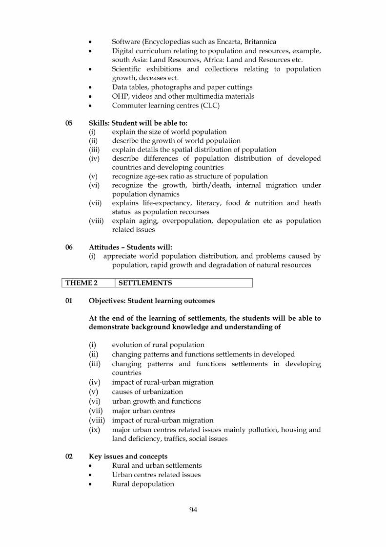
94
Software (Encyclopedias such as Encarta, Britannica
Digital curriculum relating to population and resources, example, south Asia: Land Resources, Africa: Land and Resources etc.
Scientific exhibitions and collections relating to population growth, deceases ect.
Data tables, photographs and paper cuttings
OHP, videos and other multimedia materials
Commuter learning centres (CLC) 05 Skills: Student will be able to:
(i) explain the size of world population (ii) describe the growth of world population (iii) explain details the spatial distribution of population (iv) describe differences of population distribution of developed
countries and developing countries (v) recognize age-sex ratio as structure of population (vi) recognize the growth, birth/death, internal migration under
population dynamics (vii) explains life-expectancy, literacy, food & nutrition and heath
status as population recourses (viii) explain aging, overpopulation, depopulation etc as population
related issues
06 Attitudes – Students will: (i) appreciate world population distribution, and problems caused by
population, rapid growth and degradation of natural resources
THEME 2 SETTLEMENTS 01 Objectives: Student learning outcomes
At the end of the learning of settlements, the students will be able to demonstrate background knowledge and understanding of
(i) evolution of rural population
(ii) changing patterns and functions settlements in developed
(iii) changing patterns and functions settlements in developing countries
(iv) impact of rural-urban migration
(v) causes of urbanization
(vi) urban growth and functions
(vii) major urban centres
(viii) impact of rural-urban migration
(ix) major urban centres related issues mainly pollution, housing and land deficiency, traffics, social issues
02 Key issues and concepts
Rural and urban settlements
Urban centres related issues
Rural depopulation

95
03 Suggested learning activities
Group work and discussions
Workshops/seminars
Practical exercises
Use of computer learning centers (CLCs)
Use of multimedia room
Collection of photographs, pictures, pamphlets etc. 04 Suggested learning resources
World and regional maps to recognize the distribution of settlements
Literature published by UDA and other institutions
Software (Encyclopedias such as Encarta and Britannica)
Digital Curriculum relating to settlements, example, “Garbage, Garbage, Garbage” and Urban Renewal
Photographs and pictures
Videos, OHP and other multimedia material
05 Skills: Student will be able to:
(xiv) follow the evolution (history) of rural population
(xv) recognize changing patterns and functions of developed and developing countries
(xvi) observe impact of rural-urban migration
(xvii) study the causes of urbanization
(xviii) observe urban growth and functions
(xix) recognize major urban centres
(xx) assume the impact of rural-urban migration
(xxi) distinguish major urban centres, related issues, example mainly pollution, housing and land deficiency, traffics, social issues
06 Attitudes – Students will:
(i) Consider the expansion of human settlements, their evolution and relationship with physical geographical factors.
THEME 3 ECONOMIC ACTIVITIES 01 Objectives: Student learning outcomes
At the end of the learning of rocks and soils, the students will be able to demonstrate background knowledge and understanding of
(i) crop cultivation and differences between extensive (shifting), subsistence agriculture, commercial plantation, mixed and commercial grain.
(ii) the cultivation of cut flowers and fruits in horticulture.
(iii) different production and other uses of forestry, their significance to protect watershed, wildlife habitats and management.
(iv) marine/fresh/brackish water fishing areas of the would, issues related to fishery resources, example, pollution and depletion and fisheries management

96
(v) Animal husbandry types, example, cattle, sheep, poultry, goat, swine etc. main products of animal husbandry, example, meet, milk and other product, major livestock ranching areas, issues and management of livestock ranching of the world
(vi) mining and quarrying of petroleum, coal and iron ore mining and major mining and production areas, and new trends.
(vii) major types and areas manufacturing industries of the world, salient characteristics, location factors and other infrastructures
(viii) location factors, production patterns, trade patterns, use & level of
(ix) nature of service industries
(x) nature & characteristics trade and transport
(xi) communication, which use to sharing ideas, information, and messages
(xii) use of press, TV, Telephone, Radio, Postal, e-communications
(xiii) national and international levels tourisms, factors affecting for tourism, and role of tourism for economic development
02 Key issues and concepts
Spatial patterns of economic activities
Food crops and issues
Agro based industrial material
Forestry, issues, sustainable development
Fishery and fishery management
Mining, quarrying and the environment
Service industries and economic development, and issues
03 Suggested learning activities
Group discussions and group works
Workshops/seminars and visits to Porvincial/Zonal-wise agricultural, industrial and scientific exhibitions
Use of computer learning centers (CLCs)
Use of multimedia room
Collection of photographs and pictures relating to economic activities
Conduct practical exercises to collect secondary information relating to economic activities
04 Suggested learning resources
World and regional maps, illustrate the different economic activities
Literature surveys to collect additional readings, photographs, pictures, data tables, pamphlets etc.
Use of software (Encyclopedias such as Encarta and Britannica, software on Geography and Social Studies)
Economic and scientific exhibitions
OHP, videos and other multimedia materials 05 Skills: Student will be able to:

97
(i) describe crop cultivation and their world distribution, example, extensive (shifting), subsistence agriculture, commercial plantation, mixed and commercial grain etc..
(ii) recognize the horticulture from other crop cultivation (iii) recognize forestry as primary industry, production and other uses
of forestry, their significance to protect watershed, wildlife habitats
(iv) realize the significance of management of forestry (v) identify different fishery types, example, marine/fresh/brackish
fishery. (vi) explain the issues related to fishery resources, example, pollution
and depletion (vii) identify why need fishery management ?. (viii) recognize animal husbandry types, example, cattle, sheep,
poultry, goat, swine etc. (ix) explain the main products of animal husbandry, example, meet,
milk and other product (x) Recognize the major livestock ranching areas (xi) explain the issues and management of livestock ranching of the
world (xii) recognize mining of petroleum, coal and iron, and major mining
and production areas using maps, explain new trends. (xiii) recognize major types and areas manufacturing industries of the
world using maps, and salient characteristics, location factors and other infrastructures
(xiv) describe location factors, production patterns, trade patterns in different industries.
(xv) explain the nature and chrematistics of service industries (xvi) explain the nature & characteristics trade and transport (xvii) use communication to sharing ideas, information, and messages,
example press, TV, telephone, radio, postal, e-communications (xviii) explain national and international levels of tourisms, factors
affecting, and role of tourism for economic development
06 Attitudes – Students will: (i) appreciate the value of different economic activities (ii) realize the effects economic activities on the physical
environment and appreciate the need for sustainable development
THEME 4 DEVELOPMENT
01 Objectives: Student learning outcomes
At the end of the study of the physical environment of Sri Lanka, the students will be able to demonstrate background knowledge and understanding of:
(i) measuring of development using Per Capita, GDP, GNP, PQLI, HDI, PPP and other measures
(ii) identifying developed & developing countries and their major characteristics

98
(iii) the concept of sustainable development with approaches and practices
(iv) role of selected organizations in development, example, UNFPA, UNEP, UNDP, FAO, WTO, WHO, SAARC, OPEC, IUCN, WB, G7
02 Key issues and concepts
Geological and hydrological relationships
Geological history
Mineralogical differentiation
Minerals and rocks
Climatic factors
Dynamic atmosphere
Relationships between altitude, landforms, climate, fauna and flora
03 Suggested learning activities
Practical exercise with field visits
Group discussions, individual assignments
Conduct survey emphasizing social and economic issues
Use of computer learning centers (CLCs)
Use of EFCs
Use of multimedia room
Collection of photos and pictures in relating to sub topics. 04 Suggested learning resources
National Atlas (School Edition, Printed by Survey Department)
Literature surveys, collect Photographs, pictures, pamphlets etc.
Software (Encyclopedias such as Encarta, Britannica)
Digital Curriculum, example, Sustainable Development and other related topics
Seminars, workshops and scientific exhibitions conduct by National/International Organizations.
OHP, videos and other multimedia materials 07 Skills: Student will be able to:
(i) recognize the level of development (ii) distinguish the measures of development, example Per Capita,
GDP, GNP, PQLI, HDI, PPP etc. (iii) identify developed & developing countries and their major
characteristics (iv) explain concept of sustainable development with approaches and
practices (v) explain role of selected organizations in development, national
and international, example, UNFPA, UNEP, UNDP, FAO, WTO, WHO, SAARC, OPEC, IUCN, WB, G7
06 Attitude: Student will:
(i) apply positive thinking to economic and social developments, related issues, and their relationship to worldwide organizations.
99
ANNEX 9. ACTION PLAN FOR MODERNIZING GRADES (10 - 11) - GEOGRAPHY CURRICULUM
TASK RESPONSIBILITY TIME FRAME
2004 2005 2006 2007
1. Form Advisory Committees Director General, NIE
2. Conduct Advisory Committee Meetings Director General, NIE
3. Select Resource Persons for O/L Geography Subject
Director - Social Sciences, NIE
4. Prepare A/L Geography Core Syllabus Content Chief Project officer, O/L, NIE
5. Educate Resource Persons on O/L Geography Curriculum
Chief Project officer, O/L, NIE
6. Prepare Teachers' Guides for Grade 10 Chief Project officer, O/L, NIE
7. Prepare In-Service Materials for O/L Geography Curriculum
Chief Project officer, O/L, NIE
8. Prepare Textbooks for Grade 10 Commissioner, Publications
9. Educate A/L Geography Teachers Chief Project officer, O/L, NIE
10. Prepare Teachers' Guides for Grade 11 Chief Project officer, O/L, NIE
11. Prepare Textbooks for Grade 11 Commissioner, Publications *
12. Implement New Curriculum - Grade 10 Ministry of Education
13. Monitor and Obtain Feedback through O/L Director, Social Sciences, NIE

100
ANNEX 10. ACTION PLAN FOR MODERNIZING GRADES (12 - 13) - GEOGRAPHY CURRICULUM
Resource Persons
14. Implement New Curriculum - Grade 11 Ministry of Education
Note: 1. The time intervals indicated are three months each. 2. It is expected that each task is completed within the stipulated period. 3. It is recommended that the proposed guidelines are adhered to when developing the curriculum material. 4 Teacher education should be an on-going process, starting with Grade 10, and continued to cover Grade 11.

101
TASK RESPONSIBILITY TIME FRAME
2004 2005 2006 2007
1. Form Advisory Committees Director General, NIE
2. Conduct Advisory Committee Meetings Director General, NIE
3. Select Resource Persons for A/L Geography Subject Director - Social Sciences
4. Prepare A/L Geography Syllabuses Chief Project officer, A/L, NIE
5. Prepare Teachers' Guides for Grade 12 Chief Project officer, A/L, NIE
6. Educate Resource Persons on A/L Geography Curriculum
Chief Project officer, A/L, NIE
7. Prepare In-Service Materials for A/L Geography Curriculum
Chief Project officer, A/L, NIE
8. Prepare Textbooks for Grade 12 Commissioner, Publications *
9. Educate A/L Geography Teachers Chief Project officer, A/L, NIE
10. Prepare Teachers' Guides for Grade 13 Chief Project officer, A/L, NIE
11. Prepare Textbooks for Grade 13 Commissioner, Publications *
12. Implement New Curriculum - Grade 12 Ministry of Education
102
13. Monitor and Obtain Feedback through A/L Resource Persons
Director,Social Sciences
14. Implement New Curriculum - Grade 13 Ministry of Education
Note: 1. The time intervals indicated are three months each. 2. It is expected that each task is completed within the stipulated period. 3. It is recommended that the proposed guidelines
are adhered to when developing the curriculum material. 4. Teacher education should be an on-going process, starting with Grade 12, and continued to cover Grade 13.

103
APPENDIX 11:
LIST OF EQUIPMENT FOR THE ENVIRONMETAL FIELD
STUDY CENTRES (RESOURCES CENTRES) – ON SITE Permanent Anemometer 1 Binoculars 5 *Bottom grab 1 Bunsen burners 5 Burette stands 5 Compass 2 A pair of dividers 5 Gas container 1 Meter ruler 1 Microscopes (x 600) 5 Microscope (x 1000) 1 Nylon rope (100 m) 1 *Plankton net 2 Plant presser 5 Plastic bottles (small) 5 Plastic bottles (large) 2 Plastic trays 5 Plastic ruler (30cm) 5 Pocket magnifiers 5 *Salinometer 1 *Secchi disc 2 Sieves for soil (set) 1 Soil corer 1 Soil pH and moisture
Tester 1 Stereo microscope 5 Telescope with tripod 1 Thermometer (0 – 100) 5 Thermometer (min.-max.) 1 Glassware, accessories Acid resistant dropping Pipettes 2 Beaker (50 ml) 5 Beaker (100 ml) 5 Beaker (250 ml) 5 Beaker (500 ml) 5 Beaker (1000 ml) 2 Burettes (50 ml) 5 Burettes (100 ml) 5 Cylinder (25 ml) 5
Dropping pipettes (10 ml) 2 Flask, t. (100 ml) 5 Flask, t. (250 ml) 5 Flask, t. (500 ml) 5 Flask, v. (250 ml) 5 Flask, v. (500 ml) 5 Flask, c. (250 ml) 5 Glass rods 5 Glass funnels 2 *Glass water sampl. bottles 5 (white) *Glass water samp. bottles 5
(brown) Microscope slides (package) 1
and cover slips (package) 1 Petri dishes with covers 10 Watch glasses 5 Others Blades (package) 2 Blotting paper (100 sheets) 1 Hand spade 1 Herbarium 2 Herbarium paper (package) 2 Insect needles (package) 2 Insect boxes 2 Marker pens 5 pH paper (package) 1 Pinsets, straight 5 Pinsets, curved 5 Reagent bottles (white) 5 Reagent bottles (brown) 5 Rubber funnel 2 Rubber cloves 10 Sampling bags (package) 2 Chemicals Acetic acid 2 l Aluminium powder 100 g Ammonia solution 2 l Ammonium acetate 100 g
104
Ammonium carbonate 250 g Ammonium chloride 500 g Ammonium dichromate 100 g Ammonium nitrate 100 g Ammonium sulphate 500 g Amylase 100 g Aniline blue 25 g Antimony oxide 50 g Aqua destillata 2 l Barium carbonate 200 g Benzoic acid 100 g Calcium carbonate 500 g Calcium hydroxide 500 g Calcium nitrate 250 g *Canada balsam/DPX mountant Carbon tetrachloride 500 ml *Clove oil 500 ml Cobalt nitrate 100 g Cobalt II chloride 200 g Copper II chloride 100 g Copper II nitrate 250 g Copper II oxide 100 g Copper II sulphate 500 g Diastase 250 g Ethanol 2 l *Ethyl acetate 100 g Feling’s solution I 500 ml Feling’s solution II 250 g Ferrous sulphate 250 g Formaldehyde 2 l Formalin 1 l *Glycerin 250 ml Hydrochlorid acid 2 l Iron fillings 500 g Lamp sprit 2 l
Lead carbonate 250 g Lead dioxide 100 g Lead nitrate 500 g Magnesium ribbon 100 g Manganous sulphate dehydrate 100 g Methanol 500 ml Methyl orange 50 g Methyl red 100 g Nestler reagent 100 ml Nitric acid 2 l Nitrobenzene 250 ml pH buffer Potassium chloride 100 g Potassium dichromate 250 g Potassium hydroxide 500 g Potassium sulphite 100 g *Rose Bengal indicator *Salicylic acid Soda lime 500 g *Sodium azide Sodium bicarbonate 250 g Sodium carbonate 500 g Sodium hydrate 500 g Sodium sulphite 250 g *Sodium tiosulphate pentahydrate *Starch solution 500 ml Strontium carbonate 250 g Strontium nitrate 250 g Sulphuric acid 2 l Sulpher roll 100 g *Xylene Zinc foil 250 g Zinc oxide 50 g
Compiled by Hamari, Risto, 2004
Environment Subject Specialist.
Additional List for Geography Subject Globes 2 1:50000 metric maps 4 Wall maps (World) Measuring Tape (100’) 1 Physical 1 Rock Sample kit 1 Thematic 4 World Atlas Books 2 Wall Maps (Sri Lanka) Sri Lanka Atlas Books 2
Physical 1 Hammer (geological) 1 Thematic 4 Satellite Image (Sri Lanka) 1 Satellite Image (Sri Lanka) 1
Katupotha, 2004

104
ANNEX 12: ASSESSMENT MOBILITY, TEACHING-LEARNING ASPECTS ANS SIGNIFICANT LINKAGES WITH BASIC COMPETENCIES
Assessment modality Comments in terms of teaching-learning aspects ( for) Significant linkages with Basic Competencies 1. Individual assignments Deepening the comprehension
of a lesson topic, Judicious selection, applying and reorganizing knowledge, problem-solving, reasoning, Connections to real life, Developing self-learning skills.
A – with aspects depending on topic, B - with aspects depending on topic, C – particularly in Religion, E – very significantly.
2. Individual projects Deepening the comprehension of a lesson topic, multidisciplinary approaches, Judicious selection, applying and reorganizing knowledge, problem-solving, reasoning, Connections to real life, Developing self-learning skills, Advance planning and organization of activities, Self assessment and correction, Report writing.
A – with aspects depending on topic, B - with aspects depending on topic, C – particularly in Religion, E – very significantly.
3. Surveys Advance planning and organization of activities., multidisciplinary approaches, Preparation of questionnaires, data tables, Collection of data, Conclusions based on data, Connections to real life, Cooperative learning, Developing self-learning skills, Self assessment and correction and report Writing
A – with aspects depending on topic, B - with aspects depending on topic, C – particularly in Religion, E – very significantly.
Assessment modality Comments in terms of teaching-learning aspects ( for) Significant linkages with Basic Competencies

105
4. Observational activities Advance planning and organization of observational activities, Conclusions based on observations, Connections to real life, Developing self-learning skills, Self assessment and correction, Report writing/Oral presentations.
A – with aspects depending on topic, B - with aspects depending on topic, C – particularly in Religion, E – very significantly
5. Displays Advance planning and organization of observational activities, Choice of material and economical use, Connections to real life, Developing self-learning skills, Self assessment and correction, Presentation and display skills.
A – very significantly; with aspects depending on topic, B - with aspects depending on topic, C – particularly with regard to sensitivities of viewers, E – very significantly.
6. Field visits Advance planning and organization of activities., multidisciplinary approaches, Connections to real life, Recording of observations, sketches, maps, Cooperative learning, Developing self-learning skills, Teachers to work as co-learners Report writing.
A – with aspects depending on topic, B - with aspects depending on topic, C – particularly regarding respect for site, D –with regard to use of leisure later in life, E – very significantly.
7. Oral Presentations Assessing content learning, Assessing comprehension of content, Organizing of content for presentation, Use of multimedia.
A –very significantly; with aspects depending on topic,
B - with aspects depending on topic, C – particularly regarding respect for sensitivities of
audience.
Assessment modality Comments in terms of teaching-learning aspects ( for) Significant linkages with Basic Competencies
8a. Short written tests Assessing content learning, Comprehension of content,
Very restricted scope for developing basic competencies.
8b. Essays Assessing content learning, A – with aspects depending on topic,

106
Assessing comprehension of content, Organizing of content for presentation, Syntax, clarity of diction and spelling in case of language.
B –limited; with aspects depending on topic.
9. Listening Attention span, adequacy, accuracy checked when listening speech, discussion or taped or live-programs. Writing summaries, Intelligent responses and discussions.
A – regarding ability to grasp a communication and responding intelligently.
D –with regard to use of leisure later in life, E – listening for self learning.
10.Open book Assessing content learning, Assessing comprehension of content, Quick referencing of books, Judicious selection, applying and reorganizing knowledge, problem-solving, reasoning, Developing self-learning skills.
A – regarding ability to use a written or graphic communication,
E – very significantly.
11. Practicals Hands on experiential learning, Choice of equipment/apparatus, Safety precautions and care of equipment, Developing observational skills, Recording relevant observations, Developing self-learning skills.
A – through presenting conclusions; use of tables and graphs,
B – significantly, with aspects depending on topic, C – regarding respect for specimens/material used, E – very significantly.
12. Creative activities Developing use of Simulation, Role-playing Dramatics, Singing, Use of Musical Instruments, Dance, Poster and Graphic Art, Modelling Choice of material and economical use, Cooperative learning, Developing self-learning skills, Self assessment and correction, Presentation and display skills.
A – significantly through use of song, dance and visuals B –with aspects depending on topic, C – regarding respect for sensitivities of viewers/audience. D –with regard to use of leisure later in life, E – significantly.
13. Group Projects/Assignments
All at 1 & 2 above, Team work, leadership, goal orientation,
A – significantly, B- significantly depending on aspects,

107
Identification of special skills, Opportunities for peer assessment, correction and peer direction Social responsibility, loyalty, accountability.
C – loyalty, social responsibility, accountability, E – very significantly.
14. On-site Environmental Field Studies (This is a special modality facilitated by SEMP through the rehabilitation and expansion of specially selected and developed ecologically interesting sites for on-site Field Studies)
All at 1 & 2 above, Those which are special to 3, 4. 6, 11 above, Those which are special to 13 above,
A –very significantly; with aspects depending on topic, B - very significantly with respect to the Biological and Physical Environment, C – particularly regarding respect for ecology of site, D –with regard to use of leisure later in life, E – very significantly.
(W.S. Perera, 2003).

108

109
COST EATIMATE FOR PROPOSED ACTION PLAN, GCE (OL)
Activity
Responsible Institute
2004
2005
2006
2007
COST ESTIMATE
Form Advisory Committees (AC) and Conduct AC Meetings
Director General, NIE
7,500/=
7,500.00
Select Resource Persons for OL Geography Subject Educate Resource Persons on OL Geography Curriculum Prepare and finalize OL Geography Core Syllabus Content
6 persons/3 days/2 workshops
Director - Social Sciences, NIE Chief Project officer, O/L, NIE Chief Project officer, O/L, NIE
65,000/=
65,000.00
Prepare Teachers' Guides for Grade 10-11
6 persons/Charges for
Chief Project officer, O/L, NIE
200,000/=
200,000.00
APPENDIX 14

110
writing/advisory meeting/meals and other expenditure Printing cost 200 Pages/5000 copies Papers, ink, colour printing
550,000/=
550,000.00
Prepare In-Service Materials for OL Geography Curriculum
(1) Preparation of teaching material for teacher training workshop (2) Buying user friendly software for main topics of Physical and Human Geography
Chief Project officer, O/L, NIE
(1) (2)
40,000/=
120,000/=
160,000.00
Prepare Textbooks for Grade 10-11
(1) Preparation of manuscript/ advisory committee (about 300 pages TB)
Commissioner, Publications (1)
300,000/=

111
(2) Printing 5000 copies
(2) 1,200,000/= 15,000,000.00
Educate O/L Geography Teachers Train the 300 ISA At least 10 workshops need to be held provincial level Rs. 400/= per dium payment and other expenses
Chief Project officer, O/L, NIE
600,000/=
600,000.00
Implement New Curriculum (OL)
Ministry of Education Teacher Training programmes Provincial & Zonal Levels
2,000,000/= 2,000,000.00
Monitor and Obtain Feedback through O/L Resource Persons
Director, Social Sciences, NIE 100,000/=
100,000.00
TOTAL COST
5,100,000.00
* Excluding charges for Tamil translations of curriculum, preparation of TGs and TBs, and other relevant material.

112
COST EATIMATE FOR PROPOSED ACTION PLAN, GCE (AL)
Activity
Responsible Institute
2004
2005
2006
2007
COST ESTIMATE
Form Advisory Committees (AC) and Conduct AC Meetings
Director General, NIE
7,500/=
7,500.00
Select Resource Persons for AL Geography Subject Educate Resource Persons on AL Geography Curriculum Prepare and finalize AL Geography Core Syllabus Content
6 persons/3 days/2 workshops
Director - Social Sciences, NIE Chief Project officer, O/L, NIE Chief Project officer, O/L, NIE
65,000/=
65,000.00
Prepare Teachers' Guides for Grade 10-11
Chief Project officer, O/L, NIE
200,000/=
200,000.00
APPENDIX 15

113
6 persons/Charges for writing/advisory meeting/meals and other expenditure Printing cost 200 Pages/5000 copies Papers, ink, colour printing
550,000/=
550,000.00
Prepare In-Service Materials for AL Geography Curriculum
(1) Preparation of teaching material for teacher training workshop (2) Buying user friendly software for main topics of Physical and Human Geography
Chief Project officer, O/L, NIE
(1) (2)
40,000/=
120,000/=
160,000.00
Prepare Textbooks for Grade 10-11
(1) Preparation of manuscript/ advisory committee (about 300 pages TB)
Commissioner, Publications
(1)
300,000/=

114
(2) Printing 5000 copies
(2)
1,200,000/=
15,000,000.00
Educate AL Geography Teachers Train the 300 ISA At least 10 workshops need to be held provincial level Rs. 400/= per dium payment and other expenses
Chief Project officer, NIE
600,000/=
600,000.00
Implement New Curriculum (AL)
Ministry of Education Teacher Training programmes Provincial & Zonal Levels
2,000,000/= 2,000,000.00
Monitor and Obtain Feedback through A/L Resource Persons
Director, Social Sciences, NIE 100,000/=
100,000.00
TOTAL COST
5,100,000.00
* Excluding charges for Tamil translations of curriculum, preparation of TGs and TBs, and other relevant material.