Fiche Technique1 Technical Guidance Note1 - aevv … · Pour les participants à la table ronde, la...
19
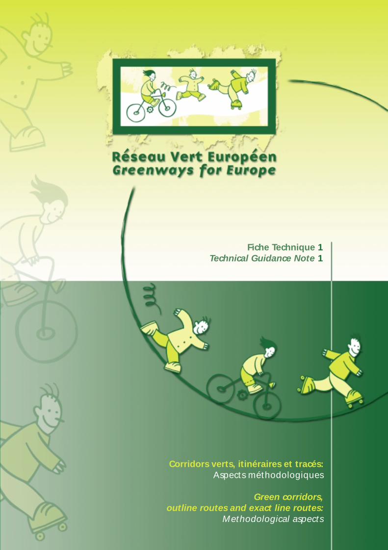
Fiche Technique 1 Technical Guidance Note 1 Corridors verts, itinéraires et tracés: Aspects méthodologiques Green corridors, outline routes and exact line routes: Methodological aspects
Transcript of Fiche Technique1 Technical Guidance Note1 - aevv … · Pour les participants à la table ronde, la...
Fiche Technique 1Technical Guidance Note 1
Corridors verts, itinéraires et tracés:Aspects méthodologiques
Green corridors, outline routes and exact line routes:
Methodological aspects

Abréviations -Abbreviations
AEVV: Association européenne des Voies vertes
AMNO: Aire Métropolitaine du Nord Ouest
ADV: Association de Développement des Véloroutes
BIM: Brussels Instituut voor Milieubeheer
CETE: Centre d'Etudes Techniques de l'Equipement
DGATLP: Direction Générale de l'Aménagement du Territoire, du Logement et du Patrimoine
EGWA: European Greenways Association
IBGE: Institut Bruxellois pour la Gestion de l'Environnement
MRW: Ministère de la Région wallonne
MET: Ministère de l'Equipement et des Transports (Région wallonne)
NWMA: North Western Metropolitan Area
RAVeL: Réseau Autonome des Voies Lentes
REVER: Réseau Vert Européen-Greenways for Europe
Rédaction - Editing:Benoît Vermeiren (Survey et Aménagement)
Contributions et relecture - Contributions and proof-reading: Anne Debras (AEVV-EGWA),Anne-Catherine Louette (AEVV-EGWA),
Antonio Fernandes Martins(AEVV-EGWA)
Traduction - Translation:ASAP
Pré-presse et impression - Pre-press and printing: Colorisprint (Namur - Belgique)
Ed. resp.Joaquín Jiménez. AEVV-EGWA
Gare de Namur boîte 27,5000 Namur(B)
Dépôt légal: D/2001/9452/2
Namur, décembre 2001
Ne peut être vendu - Not for sale.
Toute reproduction interdite - All reproduction prohibited.

1
SOMMAIRE
1 Objet de la fiche 3
2 Recommandations générales 3
2.1 Développement durable du réseau vert (qu'il soit européen, national, régional ou local) . . . . . . . . . . . . . . 32.2 Respect des objectifs définis par le Schéma directeur du REVER . . . . . . . . . . . . . . . . . . . . . . . . . . . . . . . . . . . . . . . . . . 32.3 Le «projet» comme base de constitution d'un réseau vert . . . . . . . . . . . . . . . . . . . . . . . . . . . . . . . . . . . . . . . . . . . . . . . . . 4
3 Le «corridor vert» 4
3.1 Définition de la notion de «corridor vert» . . . . . . . . . . . . . . . . . . . . . . . . . . . . . . . . . . . . . . . . . . . . . . . . . . . . . . . . . . . . . . . . . . . . 43.2 Critères de sélection d'un «corridor vert» . . . . . . . . . . . . . . . . . . . . . . . . . . . . . . . . . . . . . . . . . . . . . . . . . . . . . . . . . . . . . . . . . . . . . 4
4 L' «itinéraire» 5
4.1 Définition de la notion d' «itinéraire» . . . . . . . . . . . . . . . . . . . . . . . . . . . . . . . . . . . . . . . . . . . . . . . . . . . . . . . . . . . . . . . . . . . . . . . . . 54.2 Méthodologie pour la sélection d'un «itinéraire» . . . . . . . . . . . . . . . . . . . . . . . . . . . . . . . . . . . . . . . . . . . . . . . . . . . . . . . . . . . . 5
5 Le «tracé» 6
5.1 Définition de la notion de «tracé» . . . . . . . . . . . . . . . . . . . . . . . . . . . . . . . . . . . . . . . . . . . . . . . . . . . . . . . . . . . . . . . . . . . . . . . . . . . . . 65.2 Méthodologie pour l'étude d'une «section d'itinéraire» en vue de définir un tracé . . . . . . . . . . . . . . . . . . . . . 6
6 Tableau de synthèse des niveaux, types et méthodes 7
7 Schémas synthétiques des méthodologies 7
7.1 Corridor vert . . . . . . . . . . . . . . . . . . . . . . . . . . . . . . . . . . . . . . . . . . . . . . . . . . . . . . . . . . . . . . . . . . . . . . . . . . . . . . . . . . . . . . . . . . . . . . . . . . . . . . . 77.2 Itinéraire . . . . . . . . . . . . . . . . . . . . . . . . . . . . . . . . . . . . . . . . . . . . . . . . . . . . . . . . . . . . . . . . . . . . . . . . . . . . . . . . . . . . . . . . . . . . . . . . . . . . . . . . . . . 87.3 Tracé . . . . . . . . . . . . . . . . . . . . . . . . . . . . . . . . . . . . . . . . . . . . . . . . . . . . . . . . . . . . . . . . . . . . . . . . . . . . . . . . . . . . . . . . . . . . . . . . . . . . . . . . . . . . . . . 8
8 Conclusion 8
9 Annexes 8
9.1 Participations . . . . . . . . . . . . . . . . . . . . . . . . . . . . . . . . . . . . . . . . . . . . . . . . . . . . . . . . . . . . . . . . . . . . . . . . . . . . . . . . . . . . . . . . . . . . . . . . . . . . . 89.2 Bibliographie . . . . . . . . . . . . . . . . . . . . . . . . . . . . . . . . . . . . . . . . . . . . . . . . . . . . . . . . . . . . . . . . . . . . . . . . . . . . . . . . . . . . . . . . . . . . . . . . . . . . . . 9
10Samenvatting 10
11 Zusammenfassung 10
12 Objective of the leaflet 11
13 General recommendations 11
13.1 Sustainable development of a green network (whether European, regional or local) . . . . . . . . . . . . . . . . . . . 1113.2 Respect of the objectives defined by the REVER Outline Plan . . . . . . . . . . . . . . . . . . . . . . . . . . . . . . . . . . . . . . . . . . . . . 1113.3 A «project» as the basis for constituting a green network . . . . . . . . . . . . . . . . . . . . . . . . . . . . . . . . . . . . . . . . . . . . . . . . . 12

2
Co
rrid
ors
ver
ts, i
tin
érai
res
et t
racé
s:A
spec
ts m
éth
od
olo
giq
ues
Gre
en c
orr
ido
rs, o
utl
ine
rou
tes
and
exa
ct li
ne
rou
tes:
Met
ho
do
log
ical
asp
ects
Fich
e te
chn
iqu
e 1
Tech
nic
al g
uid
ance
no
te 1
14 The «green corridor» 12
14.1 Definition of the concept of a «green corridor» . . . . . . . . . . . . . . . . . . . . . . . . . . . . . . . . . . . . . . . . . . . . . . . . . . . . . . . . . . . . . 1214.2 Selection criteria for a «green corridor» . . . . . . . . . . . . . . . . . . . . . . . . . . . . . . . . . . . . . . . . . . . . . . . . . . . . . . . . . . . . . . . . . . . . . . 12
15 The «outline route» 13
15.1 Definition of the concept of an «outline route» . . . . . . . . . . . . . . . . . . . . . . . . . . . . . . . . . . . . . . . . . . . . . . . . . . . . . . . . . . . . . 1315.2 Methodology for choosing an «outline route» . . . . . . . . . . . . . . . . . . . . . . . . . . . . . . . . . . . . . . . . . . . . . . . . . . . . . . . . . . . . . . 13
16 The «exact line route» 14
16.1 Definition of the concept of a «exact line route» . . . . . . . . . . . . . . . . . . . . . . . . . . . . . . . . . . . . . . . . . . . . . . . . . . . . . . . . . . . 1416.2 Methodology for the study of a «section of outline route» to define a section . . . . . . . . . . . . . . . . . . . . . . . . . 14
17 Summary table of the levels, types and methods 15
18 Summary diagrams of methodologies 15
18.1 Green corridor . . . . . . . . . . . . . . . . . . . . . . . . . . . . . . . . . . . . . . . . . . . . . . . . . . . . . . . . . . . . . . . . . . . . . . . . . . . . . . . . . . . . . . . . . . . . . . . . . . . 1518.2 Outline route . . . . . . . . . . . . . . . . . . . . . . . . . . . . . . . . . . . . . . . . . . . . . . . . . . . . . . . . . . . . . . . . . . . . . . . . . . . . . . . . . . . . . . . . . . . . . . . . . . . . . 1518.3 Exact line route . . . . . . . . . . . . . . . . . . . . . . . . . . . . . . . . . . . . . . . . . . . . . . . . . . . . . . . . . . . . . . . . . . . . . . . . . . . . . . . . . . . . . . . . . . . . . . . . . . 16
19 Conclusion 16
20Appendixes 16
20.1 Participation . . . . . . . . . . . . . . . . . . . . . . . . . . . . . . . . . . . . . . . . . . . . . . . . . . . . . . . . . . . . . . . . . . . . . . . . . . . . . . . . . . . . . . . . . . . . . . . . . . . . . 1620.2 Bibliography . . . . . . . . . . . . . . . . . . . . . . . . . . . . . . . . . . . . . . . . . . . . . . . . . . . . . . . . . . . . . . . . . . . . . . . . . . . . . . . . . . . . . . . . . . . . . . . . . . . . . 16

1 OBJET DE LA FICHE
Dans le cadre de la mise en place du REseau VertEuRopéen (REVER) pour l’Aire Métropolitaine duNord-Ouest (AMNO), les partenaires du projet ontdécidé d’échanger leurs expériences au niveau de laméthodologie, en particulier en ce qui concerne laconception des réseaux verts et voies vertes.
Ainsi, une table ronde (action n°2) a été organisée àBruxelles les 05-06/10/2000 sur ce thème où chaquepartenaire a pu faire part de ses pratiques. L’objectifde cette table ronde était de mettre au point une struc-ture méthodologique globale. Cette table ronde a étécomplétée à Namur (Belgique) par un atelier pratiqued’utilisation et d’évaluation de la méthode les 31/05-01/06/2001.
De ces travaux résulte la présente fiche technique quiconstitue un outils à l’usage des promoteurs de voiesvertes et des techniciens en charge de leur aménage-ment. Elle doit toutefois être considérée davantagecomme un «aide mémoire», listant les démarchesnécessaires à l’étude que comme un guide méthodo-logique complet à suivre pas à pas. On n’y trouvepas, par exemple, toutes les indications pour effectuerun relevé botanique ou une analyse des ouvrages d’artjalonnant la voie verte. Pour ces questions, les spé-cialistes respectifs devront être consultés au momentopportun.
L’approche méthodologique proposée par les partici-pants à cette table ronde se veut donc générale, maiségalement, souple afin qu’elle puisse s’adapter àchaque contexte local, régional et/ou national, cecontexte étant défini par des objectifs et des struc-tures institutionnelles propres à chacun.
2 RECOMMANDATIONS GÉNÉRALES
2.1 Développement durable du réseau vert(qu’il soit européen, national, régional oulocal)
Afin que le réseau vert puisse être conçu dans unelogique de développement durable, tant pour son ins-cription dans une vision à long terme (développementdu réseau) que pour son maintien dans le temps (parl’entretien et le respect des infrastructures, notam-ment), les intervenants ont privilégié deux axes de tra-vail essentiels :
• Une évaluation de la demande et sa validation.
Tout projet de mise en place d’un réseau vert (àl’échelle locale, régionale, nationale et/ou européen-ne) doit de préférence être la réponse à une demanderéelle ou potentielle.
L’identification de celle-ci répond à un double objectif:d’une part, elle permet d’apporter un argumentairequant à la possibilité de mise en place d’un réseauvert ; d’autre part, elle permet de préciser certains
choix, notamment en termes d’aménagement et deservices. Toutefois, l’absence de demande ne doit pasnécessairement faire avorter le projet. Plusieurs situa-tions ont démontré que l’offre pouvait susciter lademande.
De plus, le projet de création d’un réseau vert devraitêtre validé par les structures institutionnelles et lesassociations promotrices de cette infrastructure.
• Une gestion appropriée et durable du projet
Pour garantir la pérennité tant structurelle (infrastruc-ture) que fonctionnelle (usage et animation) duréseau vert, on associera dès le début du projet lesacteurs concernés (population, collectivités, proprié-taires terriens, associations, gestionnaires, etc.) à lavie du réseau et ce suivant diverses formes propres àchacun :
- engagements (politiques) des partenaires (tacitesou écrits : «chartes, contrats») ;
- information et formation à destination des gestion-naires ;
- rédaction et diffusion de «guides de bonnes pra-tiques» ;
- information continue auprès des tour opérators etdes usagers (via les médias, les organismes d’infor-mation touristique, le balisage, etc.).
Ces actions devraient permettre de faire une évalua-tion continue du réseau afin d’en corriger les imper-fections et réorienter son développement.
Ces divers moyens devront aborder :
- la gestion technique (entretien, réparation, rénova-tion, réhabilitation) de l’infrastructure ;
- la gestion écologique du réseau ;
- la gestion et l’intégration paysagères du réseau ;
- la gestion du patrimoine sur ou à proximité duréseau ;
- la gestion touristique du réseau ;
- la promotion du respect des infrastructures duréseau ;
- etc.
2.2 Respect des objectifs définis par leSchéma directeur du REVER
Pour les participants à la table ronde, la mise en placedes réseaux verts et des voies vertes devrait répondreaux objectifs définis par le Schéma directeur duREVER.
Pour rappel, on entend par «voie verte» : «voie decommunication autonome réservée aux déplacementsnon-motorisés, développée dans un souci d’aménage-ment intégré valorisant l’environnement et la qualitéde vie, et réunissant des conditions suffisantes de lar-geur, de déclivité et de revêtement pour garantir uneutilisation conviviale et sécurisée de tous usagers detoute capacité».
3

La voie verte représente l’élément majoritaire consti-tutif du réseau vert. Peuvent également s’intégrer auréseau vert, tout en restant minoritaires, les voies decirculation dont la charge et la vitesse du trafic moto-risé sont faibles ainsi que les infrastructures et/ou lesréseaux réservés, en principe, à un seul usager (souscertaines conditions techniques et fonctionnellesd’utilisation).
Le Schéma directeur du REVER définit les caractéris-tiques d’un réseau vert comme suit :
« ...
- le réseau doit privilégier les modes de déplacement«doux» et la circulation motorisée doit, si possible, êtreexclue (à l’exception des riverains et des services d’entre-tien ou de secours) ou tout le moins, limitée (notam-ment sur les routes tranquilles, en particulier en milieuurbain, ou à proximité des zones d’activités écono-miques et de sécurité);
- le réseau doit promouvoir un usage partagé des infra-structures et doit être utilisé au moins par deux usagersnon-motorisés. Ces usagers sont les piétons, les per-sonnes à mobilité réduite, les cyclistes, les patineurs et,le cas échéant , les cavaliers et les skieurs de fond (oufondeurs);
- le réseau est à usage multiple : déplacements quoti-diens et fonctionnels ; déplacements de loisirs, sportifs ettouristiques ; jeux et animations.
- Le réseau doit être facilement accessible : accessibilitéphysique (accessibilité pour un plus grand nombred’usagers au niveau du confort de déplacement (dénive-lés quasi nuls, confort de revêtement) avec un soin par-ticulier pour l’accessibilité des personnes à mobilitéréduite), accessibilité fonctionnelle (informations - ser-vices aux usagers), intermodalité (notamment accessi-bilité en transports en commun) et accessibilité sociale(ouverture du réseau à un maximum d’usagers prove-nant de toutes les «couches» de la société civile
notion de « réseau démocratique»).
- Le réseau doit promouvoir des liaisons de longue dis-tance tout en se servant et en se greffant sur des itiné-raires régionaux et locaux tant pour développer l’usagede longue distance que l’utilisation régionale et locale.
- Le réseau doit se développer dans un souci de valorisa-tion et de conservation du patrimoine bâti (conserva-tion et réaffectation des vestiges du passé à des fins deservices : anciennes gares ferroviaires, anciennes mai-sons d’éclusier, etc.) et naturel (valorisation de couloirsécologiques et liaisons entre des zones d’intérêt écolo-gique et paysager) et historique (développement d’iti-néraires thématiques et historiques).
- Le réseau doit également offrir des services à ces usa-gers:
- la location de vélos, rollers ou chevaux ;
- l’accueil, l’hébergement et la restauration ;
- la signalisation, le balisage et le jalonnement ;
- l’information générale ou spécifique des usagers;
- l’animation récréative, touristique, culturelle et/ousportive ;
etc.»
2.3 Le «projet» comme base de constitu-tion d’un réseau vert
La promotion d’un projet a notamment pour objectifde fédérer tous les acteurs autour d’une même initia-tive. Dans ce cadre, la notion de «thématique»(thème à usage récréatif, touristique, historique ouutilitaire) est évidemment souvent constitutive duprojet soutenu. Il va évidement de soi qu’un projet demise en place d’un réseau vert doit également s’ap-puyer sur l’identification des infrastructures pouvantêtre (ré)utilisées (cf. infra).
3 LE «CORRIDOR VERT»
3.1 Définition de la notion de «corridorvert»
Les «corridors verts1» (axes, fuseaux, faisceaux),
d’une largeur approximative de 30km constituent, parleur composition, la trame de l’ensemble du réseau.Idéalement, un «corridor vert» relie un point A à unpoint B par une série de points de passage. Il doit êtretransnational et interconnecté au reste du réseau pardivers points d’ancrage, tout au long de son parcours.
3.2 Critères de sélection d’un «corridorvert»
Il n’a pas été proposé de méthodologie spécifiquepour l’établissement d’un «corridor vert». Cependant,les participants pensent que pour être retenu, un«corridor vert» devrait correspondre au moins au cri-tère n°1 de la série qui suit et répondre au moins àdeux autres critères au choix.
Ces critères2 sont :
• Critère 1 : Le «corridor vert» assure une fonction deliaison transnationale. Dans le cadre du REVER, ildoit couvrir au moins trois pays (ou régions) parte-naires du projet, ou non, mais inclus dans l’aire decoopération.
• Critère 2 : Le «corridor vert» passe par ou estconnecté aux villes importantes et/ou aux zonesdensément peuplées ;
1 Le terme de « corridor vert « peut sembler peu « esthétique « en fran-çais, il présente toutefois un triple avantage :
- il offre un concept large, non restrictif ;
- il peut permettre de faire des liens avec les « Eurocorridors « déve-loppés notamment dans le Schéma de Développement de l’EspaceCommunautaire (SDEC) ;
- il permet une compréhension aisée bilingue française/anglaise.
2 La numérotation des critères est purement indicative et n’implique enrien un ordre de préférence à l’exception toutefois du critère n°1 qui doittoujours être le premier critère nécessaire pour la sélection.
4
Co
rrid
ors
ver
ts, i
tin
érai
res
et t
racé
s:A
spec
ts m
éth
od
olo
giq
ues
Gre
en c
orr
ido
rs, o
utl
ine
rou
tes
and
exa
ct li
ne
rou
tes:
Met
ho
do
log
ical
asp
ects
Fich
e te
chn
iqu
e 1
Tech
nic
al g
uid
ance
no
te 1

• Critère 3 : Le «corridor vert» choisi rencontre desobjectifs et/ou développe une thématique (histo-rique, culturelle, patrimoniale, fonctionnelle, etc.) etce sur tout son tracé ;
• Critère 4 : Le «corridor vert» attire un large public etpromeut la diversité structurelle et culturelle del’Europe (dans le cadre du REVER) ;
• Critère 5 : Le «corridor vert» a une fonction structu-rante au niveau du Schéma directeur REVER maiségalement des réseaux verts régionaux et nationaux;
• Critère 6 : Le «corridor vert» est accessible facile-ment à l’échelle européenne et ce principalement viales transports en commun (accessibilité intermoda-le via les ports, aéroports, gares, voies d’eaux àdimension «européenne»)
Dans le cadre précis du projet REVER, chaque pays ourégion partenaire doit être traversé par, au moins, uncorridor européen. De plus, nous avons choisi d’ajou-ter des critères complémentaires pour le choix de«corridors verts» :
Critère A : le temps
Il est important de choisir un « corridor vert « pourlequel l’étude mais également les aménagementspourront être réalisés dans un laps de temps court.
Critère B : les moyens budgétaires
Un corridor vert sera choisi si les moyens budgé-taires sont clairement identifiés et semblent suffi-sants tant pour l’étude que pour la réalisation.
Critère C : les partenaires
Un corridor vert sera retenu s’il fédère, dès l’élabora-tion du projet, une série de partenaires motivés tantpour l’étude que pour la réalisation.
4 L’ «ITINÉRAIRE»
4.1 Définition de la notion d’ «itinéraire»
Une fois le «corridor vert» défini suivant les critèresprécisés ci-dessus, le promoteur du projet détermine-ra au sein de ce large espace, en moyenne 30km delarge, un cheminement et ses éventuelles variantes,soit un(des) «itinéraire(s)». Il s’agit d’une approchede type «étude de faisabilité» qui doit rester générale.Son échelle est fonction du territoire étudié. L’étudene devrait toutefois pas concerner des sections infé-rieures à 50km.
4.2 Méthodologie pour la sélection d’un«itinéraire»
Partant d’un débat sur les différentes pratiques despartenaires et en nous inspirant des méthodes britan-niques, nous avons mis au point une méthode poursélectionner les itinéraires. Notons que les phases 1aet 1b peuvent être inversées suivant le contexte insti-tutionnel et/ou structurel propre à chaque opérateur
du projet.
Phase 1a : Identification générale de la demande
Nous avons déjà évoqué plus haut l’intérêt queconstitue l’identification de la demande locale, régio-nale, nationale ou européenne.
Pour ce faire, on utilisera des indicateurs nationauxet/ou régionaux sur les déplacements «doux» (tirésnotamment des enquêtes globales sur la mobilité)que l’on testera à nouveau sur un échantillon dupublic concerné (notion d’aire de démonstration).
En complément de ce type d’informations, il y auralieu d’utiliser d’autres sources d’informations commeles études socio-économiques ou touristiques, lesenquêtes, les rencontres avec les usagers, les inter-views, l’évaluation des données européennes ounationales, les expériences antérieures analogues, etc.
Cette identification de la demande pourra ensuite êtrevalidée par les acteurs impliqués dans la mise enplace du projet d’itinéraire.
Phase 1b : Identification générale de l’itinéraire
Cette étape de l’étude se compose d’une série d’iden-tifications pour lesquelles il a été jugé préférable detravailler de façon parallèle et transversale plutôt quepar phases successives.
• Identification des infrastructures utilisables
Il y a lieu d’effectuer un repérage des infrastructuresqui peuvent être utilisées dans le cadre de l’itinérai-re. On recherchera prioritairement les infrastructuresautonomes telles que les chemins de service desvoies d’eau et les anciennes voies ferrées (cf. fichetechnique n°2). Il est important de repérer les conti-nuités et les éventuelles ruptures dans les itinérairesidentifiés. Cette identification se fera d’abord defaçon cartographique avant d’être vérifiée sur le ter-rain. Les infrastructures retenues devraient rencon-trer les caractéristiques définies par le Schéma direc-teur REVER pour la mise en place des réseaux verts.L’usage de systèmes informatiques cartographiques(SIG) est un atout pour cette étape.
• Identification des problèmes fonciers et juridiques
On effectuera un relevé général des éventuels pro-blèmes juridiques que peut/peuvent rencontrerle/les itinéraire(s).
Dans ce cadre, on abordera notamment les pro-blèmes de type foncier, principalement au niveau desanciennes voies ferrées ou chemins de halage.
Les aspects relatifs à certaines zones sensibles enmatière d’écologie, de paysage et/ou de patrimoinearchitectural et/ou archéologique seront égalementidentifiés. De la même façon, les zones d’activitéséconomiques et/ou industrielles seront repérées afind’en préciser les impacts fonciers éventuels (pas-sages de lignes électriques, accès techniques, etc.).
• Identification des partenaires
Pour qu’un projet vive, il est impératif de bien identi-fier les partenaires et ce dès la définition des choixd’itinéraires. L’objectif est de réaliser les choix en col-
5

laboration avec ces acteurs afin qu’ils puissent éga-lement s’impliquer dans le projet et en assurer la via-bilité et la durabilité.
• Identification de l’environnement
Un itinéraire doit être choisi en fonction non seule-ment de sa valeur intrinsèque mais également parrapport à son inscription dans un environnement(terme à prendre au sens large et pas uniquementécologique). Pour se faire, on essayera d’identifierdans un rayon au moins équivalent à la largeur aucorridor: l’environnement social; l’environnementéconomique ; l’environnement culturel (y compris lepatrimoine architectural et/ou archéologique) ; etl’environnement écologique et paysager.
• Identification des ressources financières
Il s’agit d’identifier les ressources financières pos-sibles qui permettront de développer l’itinéraire choi-si et ce à divers niveaux structurels (budgets euro-péens, nationaux, régionaux et locaux).
Objectifs
Ces diverses identifications permettent, notamment,de préciser la demande potentielle mais également depromouvoir une thématique.
De façon globale, cette démarche devrait débouchersur :
• l’identification des « points de blocage « qui pour-raient handicaper tel ou tel itinéraire ;
• les potentialités des divers itinéraires tant au niveaustructurel que fonctionnel.
Phase 2 : Choix de l’itinéraire définitif
L’analyse des points de blocage et des potentialitésorientera les choix des auteurs de projet et des déci-deurs. On précisera donc, dans un rapport de motiva-tion, documents cartographiques à l’appui, l’itinéraireretenu, sa continuité, ses connexions avec d’autres iti-néraires et, le cas échéant, les éventuelles alternatives.
Une étude d’itinéraire doit se dérouler sur un mini-mum de 6 mois sans les phases de consultation et deconcertation.
5 LE «TRACÉ»
5.1 Définition de la notion de «tracé»
L’itinéraire retenu (ainsi que ses variantes etconnexions), il y a lieu d’avoir une approche plus«micro», celle du «tracé». Le «tracé» est le résultatd’une étude détaillée sur une section d’itinéraired’une longueur variant généralement entre 15 et20km, parfois plus (mais certainement pas supérieu-re à 50km). Pour une étude détaillée, l’ensemble del’itinéraire est découpé en tracés.
5.2 Méthodologie pour l’étude d’une «sec-tion d’itinéraire» en vue de définir un tracé
Lors de cette étape, il s’agit d’affiner la démarche etles conclusions de l’étude de choix d’itinéraire en sui-vant un processus composé de trois phases :
Phase1: inventaire de la situation existante au niveau de la section d’itinéraire et de son environnement
Cette phase est essentielle car elle permet de faire uneréelle « radiographie « de la section (morceau de l’iti-néraire), de son environnement et de préciser lesobjectifs à atteindre. En outre, les identificationsseront de préférence menées en parallèle et de façontransversale afin de ne pas privilégier une approchepar rapport à une autre.
■ Au niveau de la section
A ce niveau, l’identification locale sera à la fois :
• Structurelle
Identification des infrastructures pouvant être utili-sées et de leur état structurel (qualité du revêtement,déclivité, état des ouvrages d’art, etc.). Une attentionparticulière sera portée à l’identification des points derupture dans l’itinéraire et des solutions qui pourrontêtre dégagées pour solutionner ces ruptures.
• Fonctionnelle
Identification des types d’usages et d’usagers actuelset potentiels de la section (cf. caractéristiques d’unréseau vert p.5-6).
• Paysagère
- Identification du paysage de la section et des alen-tours.
- Intégration de la section dans le paysage.
• Juridique
Identification des problèmes juridiques et en particu-lier ceux relatifs aux aspects fonciers (vente, location,droit de passage, servitude, etc.). Ce travail s’effectue-ra en fonction de l’analyse des informations cadas-trales et des contacts avec les riverains de la section(rencontres, enquêtes, interviews, etc.).
• Patrimoniale, architecturale et archéologique
Identification des témoins architecturaux et archéolo-giques directement liés à la section (signalisation rou-tière, fluviale ou ferroviaire ; bâtiments techniques,etc.)
■ Au niveau de l’environnement immédiat de lasection
Deux aspects environnementaux ont été retenus (lerayon à étudier sera fonction du contexte local tantstructurel qu’institutionnel) :
• L’environnement socio-économique
Dans ce cadre, on abordera diverses approches parti-culières :
- identification de la demande locale via des contacts
6
Co
rrid
ors
ver
ts, i
tin
érai
res
et t
racé
s:A
spec
ts m
éth
od
olo
giq
ues
Gre
en c
orr
ido
rs, o
utl
ine
rou
tes
and
exa
ct li
ne
rou
tes:
Met
ho
do
log
ical
asp
ects
Fich
e te
chn
iqu
e 1
Tech
nic
al g
uid
ance
no
te 1
(rencontres, enquêtes, réunions, etc.) avec lesassociations d’usagers, les groupements d’intérêttouristique, la population locale, etc.
- identification des fonctions socio-économiquesexistantes (commerces et services privés, habitat,services publics, écoles et centres scolaires, fonc-tions culturelles, attractions touristiques, etc.)
- identification des itinéraires utilitaires, récréatifs ettouristiques (existants ou en projet) pour lesmodes de déplacements non-motorisés (principa-lement les itinéraires pédestres, cyclables etéquestres) ;
- identification des autres réseaux de communicationet notamment des zones d’accès et d’échangeintermodal (connexion avec les gares ; les arrêtsdes lignes de bus, métros et tramways ; les aéro-ports et héliports ; les ports maritimes et fluviaux ;les réseaux routiers et autoroutiers).
• L’environnement écologique, paysager, architectural etarchéologique
Un relevé écologique précis de la section et de sesabords sera réalisé afin d’identifier les zones sen-sibles. La même démarche se répètera aux plans pay-sager, architectural et archéologique afin d’éviter touteerreur d’intégration au niveau de la section.
Phase 2: esquisse générale
Phase 2.1. Approche globale
Cette approche consiste en la mise au point de pro-positions générales tant pour la section que pour sonenvironnement et ce à divers niveaux : structure (revê-tement, ouvrages d’art, etc.), signalétique (légale etinformative), services à développer, desserte des ser-vices et commerces, connexion avec les réseauxlocaux, accès, etc. Il s’agit de détailler des options déjàprises au niveau du choix de l’itinéraire (cfr. Supra).Les aspects écologiques, paysagers et patrimoniaux(architecture et archéologie) devront être développéségalement. Pour certains points, il semble essentielde faire des propositions de principe déjà détaillées(pour le traitement des aires de repos, des carrefours,etc. ; par exemple).
Phase 2.2. Information et validation par les acteurslocaux
Il est souhaitable que les propositions généralessoient présentées aux acteurs institutionnels, auxassociations et à la population locale afin de les infor-mer et d’affiner les propositions.
Cette consultation sera réalisée en fonction des objec-tifs et structures propres à chacun.
Phase 3: propositions détaillées
Sur base des informations et remarques récoltéesdurant la phase 2.2, le porteur du projet peut établirdes propositions détaillées.
Ces propositions se concrétiseront par :
• la réalisation de plans techniques d’exécution (pourla création, la rénovation et/ou l’entretien de la sec-tion) ;
• la rédaction de cahier des charges (pour la création,la rénovation et/ou l’entretien de la section) ;
• la rédaction d’un programme de mesures concrètesrelatives à la gestion écologique, paysagère et patri-moniale de la section et de son environnement ainsique la formulation des conditions de son suivi;
• la rédaction d’un programme d’actions concrètesquant à l’animation et aux services à développer suret autour de la section.
Dans le cadre du REVER, cette méthodologie doit bienévidemment être adaptée au contexte institutionnelpropre à chaque partenaire. En outre, il y a lieu destructurer cette méthode en fonction du contexteenvironnemental (milieu rural, milieu semi-urbain,milieu urbain). Les propositions tant générales quedétaillées doivent toutefois répondre aux objectifs duSchéma directeur du REVER (cfr. 2.2).
Une étude de tracé (pour une distance de 20 km maxi-mum) doit se dérouler sur un minimum de 6 moissans les phases de consultation et de concertation.
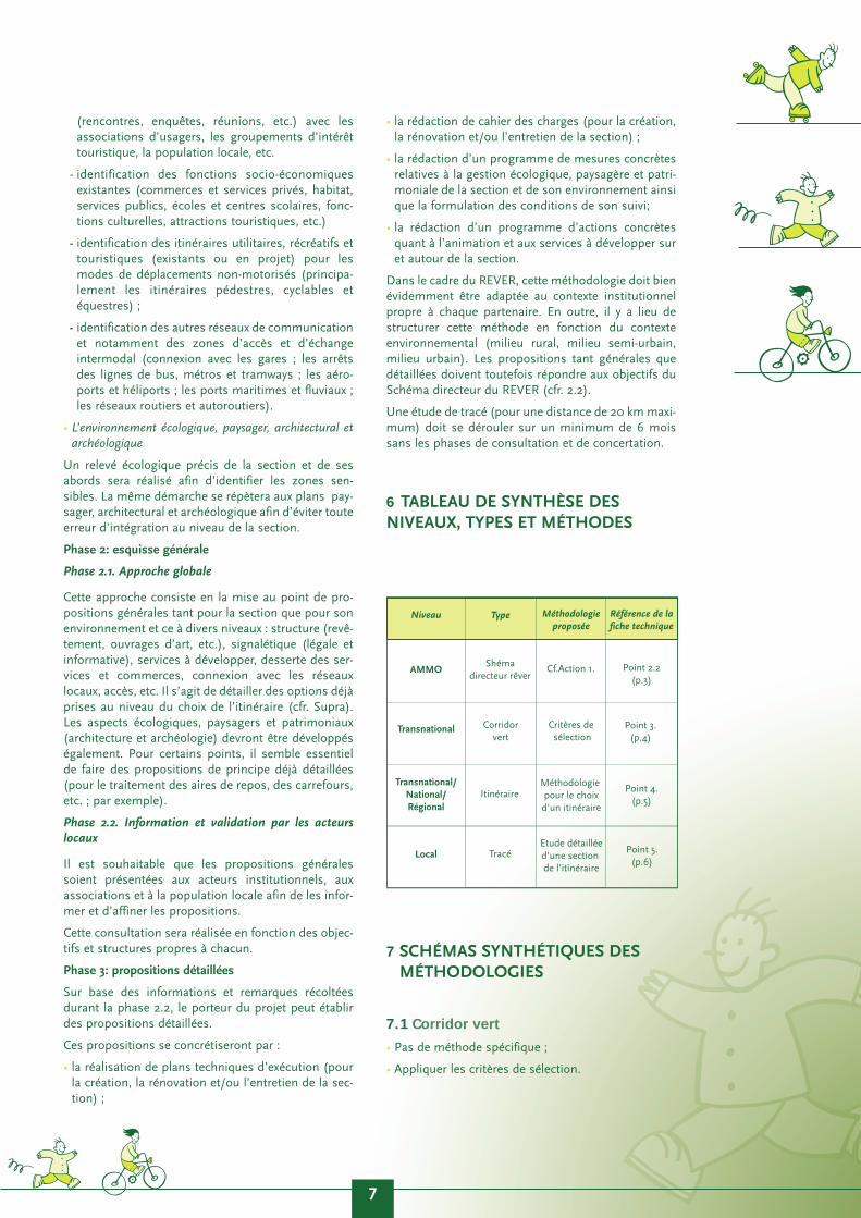
6 TABLEAU DE SYNTHÈSE DESNIVEAUX, TYPES ET MÉTHODES
7 SCHÉMAS SYNTHÉTIQUES DESMÉTHODOLOGIES
7.1 Corridor vert
• Pas de méthode spécifique ;
• Appliquer les critères de sélection.
7
AMMO
Niveau
Transnational
Local
Transnational/National/Régional
Type Méthodologie proposée
Référence de la fiche technique
Shémadirecteur rêver
Corridorvert
Critères de sélection
Point 3.(p.4)
Point 4.(p.5)
Point 5.(p.6)
ItinéraireMéthodologie pour le choixd'un itinéraire
TracéEtude détailléed'une section de l'itinéraire
Cf.Action 1. Point 2.2(p.3)
7.2 Itinéraire
7.3 Tracé
8 CONCLUSION
Ces aspects méthodologiques, analysés puis testéslors des études concrètes de conception de voiesvertes, nécessitent une application souple. En effet, lecontexte propre à chaque pays ou région d’Europeinfluencera, pour des raisons diverses, l’utilisation quisera faite de ces méthodes.
A la lecture du présent document, il apparaît claire-ment que tout bon projet de voies vertes nécessiterala constitution d’une équipe pluridisciplinaire compo-
sée notamment d’ingénieurs, de spécialistes enconservation du patrimoine culturel et naturel, de pay-sagistes, etc.
Gageons que ces méthodes puissent aider élus etconcepteurs dans la mise en place de leurs infrastruc-tures avec, pour objectif, le bien-être des usagers etdes riverains et le respect de l’environnement traversépar les voies vertes.
9 ANNEXES
9.1 Participation
Ont participé à la table ronde
• Pour la Belgique, Région de Bruxelles-Capitale :Philippe De Staercke (IBGE-BIM) et Rachelle Rubert(IBGE-BIM) ;
• Pour la Belgique, Région wallonne : NathalieSchildwachter et Dominique Debatty (MRW -DGATLP - Cellule RAVeL);
• Pour la France : Jean-Paul Lepetit (ADV) et FrançoisTortel (Ministère de l’Equipement - CETE de l’Est) ;
• Pour Le Royaume-Uni : Jim Walker (Consultant) etAndrew Ventin (Ville de Liverpool) ;
• Pour l’Irlande : Beatrice Kelly (Heritage Council) ,Tanya Comber (Heritage Council), Joss Lynam(National Waymarked Ways Advisory Comittee ofSports Council of Ireland), John Toland (Cavan-Monaghan Rural Dévelopment Co-op Society) et JimO’Sullivan (Route co-ordination Beara / LeitrimGreenways) ;
• Pour l’AEVV : Anne Debras, Anne-Catherine Louette,Benoît Vermeiren (Survey et Aménagement).
Les experts de la table ronde étaient:
• Éric Graitson et Olivier Guillitte (Laboratoired’Ecologie des Facultés agronomiques deGembloux);
• Martine Piret (Ville de Charleroi)
• Philippe Demars et Jean-Philippe Bille (MET);
• Marc Loumaye (Ville de Huy - Office du Tourisme) ;
• Jo Devrindt (Kempen en Maasland, Regionaal Land-schap).
La coordination et l’animation ont été assurées parl’AEVV :
• Coordination générale : Anne-Catherine Louette(AEVV), Anne Debras (AEVV) ;
• Animation, encadrement technique et rédaction dela fiche : Benoît Vermeiren (Survey & Amé-nagement).
8
Co
rrid
ors
ver
ts, i
tin
érai
res
et t
racé
s:A
spec
ts m
éth
od
olo
giq
ues
Gre
en c
orr
ido
rs, o
utl
ine
rou
tes
and
exa
ct li
ne
rou
tes:
Met
ho
do
log
ical
asp
ects
Fich
e te
chn
iqu
e 1
Tech
nic
al g
uid
ance
no
te 1
infrastruicturesutilisables
Partenariat
Problèmesjuridiques
Environnement
Ressourcesfinancières
Phase 1b: Identication généralede l'itinéraire
Phase 1a: Identification générale de la demande
Phase 2: Choix de l'itinéraire définitif
Structure Fonctions PaysageAspects
juridiquesPatrimoine
Phase 1:Inventaire de la situation existante au niveau de la section d'itinéraire
et de son environnement
Environnement socio-économique
Environnement écologique, paysager, architectural,
et archéologique
Phase 2:Esquisse générale
Phase 2.2.:Approche globale
Phase 3:
Phase 3:Propositions détaillées
Information et validation par les acteurs locaux

9.2 Bibliographie
Les documents suivants ont servi à la mise au point de laméthodologie :
• CETE de l’Est, Vallée de la Saône. Véloroute de Charlesle Téméraire. Dossier provisoire, juin 2000 ;
• Countryside Agency, Countryside Agency GreenwaysDemonstration: PACE process and Accreditation,2000;
• IBGE, Etude de conception du maillage vert en Régionde Bruxelles-Capitale. Rapport de la phase 1(Identification des itinéraires), 1998 ;
• MRW-DGATLP-Cellule RAVeL, Cahier spécial des
charges relatif à la réalisation d’esquisses urbanistiques
dans le cadre du projet RAVeL, 2000 ;
• MRW-DGATLP-Cellule RAVeL, Méthodologie d’inven-
taire écologique, 2000 ;
• République française (divers ministères), Réseau
d’itinéraires cyclables d’intérêt national. Véloroutes et
voies vertes. Projet de cahier des charges (Document de
travail), 11/09/2000.
9

10 SAMENVATTING
Verschillende landen van Noordwest-Europa leggengeleidelijk infrastructuur en netwerken aan voor niet-gemotoriseerde gebruikers. Die bestaan vaak uit groe-ne wegen, en we noemen ze «groene netwerken». Demethodologische benadering om deze wegen te iden-tificeren en een inrichting voor te stellen, verschiltsterk van land tot land, zelfs van streek tot streek.
Met het oog op wederzijdse uitwisseling van ervaringen expertise, wilden de partners van het REVER-pro-ject hun werkwijzen vergelijken, niet om te komen toteen gelijkvormige methode die door iedereen en ove-ral kan worden toegepast, maar eerder om een metho-dologische basis te leggen die lokaal kan worden aan-gepast.
Uitgaand van deze wens hebben ze eerst een gemeen-schappelijk taalgebruik vastgelegd om de onderdelenvan de groene netwerken te definiëren: de groene cor-ridor, de groene route en het groene traject. Op dezeterminologie werd dan een duidelijke en gestructu-reerde benaderingsmethode geënt.
De kracht van deze methodes is duidelijk gebaseerdop twee belangrijke doelstellingen voor de ontwikke-ling van de groene netwerken: identificeren van devraag en rekening houden met het leefmilieu (inruime zin) van een groene weg en/of een groen net-werk. Deze twee onderdelen structureren aldus sterkde voorgestelde methodes, die proberen een multi-disciplinaire benadering van de verwezenlijking vangroene wegen en netwerken te bevorderen.
Wij hopen dan ook dat de lezer, terwijl hij deze tech-nische fiche doorloopt, een antwoord zal vinden opzijn methodologische vragen en zal ervaren dat eenbrede benadering van deze materie noodzakelijk is.
11 ZUSAMMENFASSUNG
In verschiedenen Ländern Nordwesteuropas werdenschrittweise Infrastrukturen und Wegenetze für nicht-motorisierte Benutzer eingerichtet. Sie bestehen häu-fig aus Grünen Wegen, und wir nennen sie «GrüneWegenetze». Die methodologischen Herans-gehensweisen zur Identifizierung dieser Wege sowiezu ihrer Gestaltung unterscheiden sich deutlich voneinem Land zum anderen, ja sogar von einer Regionzur anderen.
In dem Bemühen, Erfahrungen und Expertisen auszu-tauschen, haben die Partner des Projekts REVER denWunsch geäußert, ihre Arbeitsmethoden zu verglei-chen, nicht um eine einheitliche Methode, die vonjederman und überall anwendbar ist, hervorzubrin-gen, sondern vielmehr, um eine methodologischeGrundlage, die an die örtlichen Bedingungen ange-passt werden kann, zu entwickeln.
Ausgehend von diesem Wunsch haben sie zunächsteine gemeinsame Sprache festgelegt, um dieBestandteile der Grünen Wegenetze zu definieren :den grünen Korridor, die Route und dieStreckenführung. Auf dieser Terminologie baute sicheine klare und strukturierte Methode derHerangehensweise auf.
Die Beständigkeit dieser Methoden gründet sich klarauf zwei Zielstellungen, die für die Entwicklung derGrünen Wegenetze von Bedeutung sind : dieErkennung der Nachfrage und die Berücksichtigungder Umwelt (im weiteren Sinne) eines grünen Wegesund/oder eines Grünen Wegenetzes. Diese beidenBestandteile strukturieren somit in starkem Maße dievorgeschlagenen Methoden zur Förderung eines mul-tidisziplinären Ansatzes der Einrichtung von GrünenWegen und Grünen Wegenetzen.
Wir hoffen also, dass der Leser dieser technischenDarlegung Antworten auf seine Fragen zurMethodologie erhalten und die Notwendigkeit einesbreiten Ansatzes für dieses Thema nachempfindenkönnen wird.
10
Co
rrid
ors
ver
ts, i
tin
érai
res
et t
racé
s:A
spec
ts m
éth
od
olo
giq
ues
Gre
en c
orr
ido
rs, o
utl
ine
rou
tes
and
exa
ct li
ne
rou
tes:
Met
ho
do
log
ical
asp
ects
Fich
e te
chn
iqu
e 1
Tech
nic
al g
uid
ance
no
te 1
12 OBJECTIVE OF THE LEAFLET
In the context of the implementation of REVER(REseau Vert EuRopéen - Greenways for Europe) forthe North Western Metropolitan Area, the partners tothe project decided to exchange their experience withregard to the methodology, particularly as concernsthe conception of green networks and greenways.
For this a round table was organized on the theme inBrussels on 5 - 6/10/2000 (action n° 2) where eachpartner was able to give information on its practices.The objective of this round table was to develop a glo-bal methodological structure. The round table wascompleted in Namur (Belgium) by a practical work-shop on how to use and assess the method on 31/05- 1/06/2001.
This leaflet is the result of these deliberations. Itconstitutes an instrument to be used by promoters ofgreenways and technicians in charge of outfittingthem. It should nevertheless be considered more as a«check list» of the steps needed for the study, ratherthan a complete methodological guide to be followedstep by step. For example, all the indications for takinga botanical inventory or an analysis of the construc-tion works along the greenway are not included. Forthese questions, the appropriate specialists should beconsulted when the time comes.
The methodological approach proposed by the parti-cipants in the round table is meant to be general, aswell as flexible so that it can be adapted to each local,regional and/or national context, this context beingdefined by the objectives and the institutional struc-tures specific to each.
13 GENERAL RECOMMENDATIONS
13.1 Sustainable development of a greennetwork (whether European, regional orlocal)
To ensure that the green network corresponds to thelogic of sustainable development, both as concerns itsinclusion in a long-term vision (development of thenetwork) and its maintenance over time (by maintai-ning and respecting the infrastructures, notably) par-ticipants gave priority to two essential issues:
■ Assessment and validation of demand
Any project for setting up a green network (on a local,regional, national and/or European scale) should pre-ferably be a response to real or potential demand.Identifying that demand corresponds to a two-foldobjective: on the one hand, it constitutes an argumentfor the possibility of setting up a green network, onthe other it helps clarify certain choices, particularly asconcerns facilities and services. Nevertheless, theabsence of demand need not necessarily mean aban-doning the project. Several situations have shown that
supply can create demand.
In addition, the project of creating a green networkshould be validated by institutional structures andassociations to promote that infrastructure.
■ Appropriate, sustainable management of the pro-ject
To ensure the lasting success of the green networkstructurally (infrastructure) and operationally (usageand facilities), the players concerned should be asso-ciated with the life of the project from the start (popu-lation, local authorities, landlords, associations,managers, etc.) in ways that correspond to eachagent:
• (political) commitments of the partners (tacit orwritten: «charters, contracts»);
• information and training of management;
• drafting and disseminating «good practice guides»;
• continual information to tour operators and users(by the media, tourist information offices, way mar-kings etc.).
These actions should make it possible to assess thenetwork continually, to correct any shortcomings andreorient its development.
These various means should deal with:
• technical management (maintenance, repairs, reno-vation, rehabilitation) of the infrastructure ;
• ecological management of the network ;
• management and integration of landscaping into thenetwork;
• management of the heritage on or near the network;
• tourist management of the network;
• promoting respect of the infrastructures of the net-work;
• etc.
13.2. Respect of the objectives defined bythe REVER Outline Plan
For round table participants, the implementation ofgreen networks and greenways should meet the objec-tives defined by the REVER Outline Plan.
We recall that a «greenway» is defined as : «a path fortravel restricted to non-motorized travel, developed inkeeping with integrated town and country planningenhancing the environment and quality of life, andmeeting conditions of sufficient width, slope and sur-face to guarantee convivial, safe use for all users in anycapacity».
Greenways represent the main element making up agreen network. Other types of routes with occasional,slow motorized traffic can also be integrated in thegreen network, but they should be a minority, alongwith infrastructures and/or networks meant in prin-
11

ciple for one type of user only (under certain technicaland operational conditions for use).
The REVER Outline Plan defines the characteristics of thenetwork as follows :
« ...
• The network should give priority to «alternative»traffic and motorized traffic should be excluded if pos-sible (except for persons living along the line and main-tenance or emergency services) or in any case limited(particularly on quiet roads, in urban areas or nearareas of economic activity and safety zones);
• The network should promote shared use of the infra-structures and should be used by at least two types ofnon-motorized traffic. The users include pedestrians,persons with limited mobility, cyclists, skaters, and pos-sibly horseback riders and cross-country skiers (or skitourists);
• The network is for multiple use: commuting, travel forleisure, sports and tourism, games and guided activities.
• The network should be easy to access: physical accessi-bility (accessibility for a large number of users asconcerns the comfort of travel — almost no bumps,comfortable surface - with particular care for personswith limited mobility), functional accessibility (infor-mation - services for users), intermodal transport (nota-bly access to public transport) and social accessibility(opening the network to a maximum number of usersfrom all walks of civil society (notion of «democraticnetwork»).
• The network should promote long distance connec-tions while using and adding on regional and local iti-neraries both to develop long distance use, and regionaland local use.
• The network should develop with a view to valorisingand conserving architectural heritage (conservationand reallocation of past facilities to be used for services:former railway stations, old lockhouses, etc. and natu-ral heritage (enhancement of ecological corridors andlinks with areas of interest from the ecological, landsca-pe and historical standpoints (development of thematicand historical itineraries).
• The network should also provide services to these users:
- hiring bicycles, skates or horses;
- information kiosks, food and lodging;
- road marks and signs;
- general or specific information for users;
- recreational, tourist, cultural and/or sports activi-ties;
- etc.
13.3. A «project» as the basis for constitu-ting a green network
The promotion of a project aims notably to bring allagents together in support of the same initiative. Inthis context, the concept of a «theme» (theme forrecreational, tourist, historical and/or utilitarian use)
clearly is often the basis for support of a project. Itgoes without saying that a project for implementing agreen network should also draw support from theidentification of infrastructures which could be(re)used (see below).
14 THE «GREEN CORRIDOR»
14.1 Definition of the concept of a «greencorridor»
«Green corridors3» (strips, zones, clusters) about30km wide constitute, by their existence, the backdropof the entire network. Ideally a « green corridor « linkspoint A to point B via a series of intermediary crossingpoints. It should be transnational and interconnectedwith the rest of the network by various anchor points,all along the outline route.
14.2 Selection criteria for a «green corridor»
No specific methodology was proposed to establish a«green corridor». However, the participants feel thatto be retained a «green corridor» should correspondto at least the first criterion of the series that followsand should meet at least any two other criteria
These criteria4 are:
■ Criterion 1 : A «green corridor» acts as a transna-tional connection. In the REVER context, it shouldcover at least three partner countries (or regions) orothers that are located in the co-operation area.
■ Criterion 2 : A «green corridor» passes by or isconnected to large towns and/or densely populatedareas ;
■ Criterion 3 : The selected «green corridor» meetsobjectives and/or develops a theme (historical, cul-tural, promotion of heritage, functional, etc.) alongthe entire line;
■ Criterion 4 : A «green corridor» attracts a broadaudience and promotes structural and culturaldiversity in Europe (in the REVER context, theNorth West Metropolitan Area);
■ Criterion 5 : A «green corridor» has a structuringfunction in the REVER outline plan, as well as in theregional and national green networks ;
■ Criterion 6 : A «green corridor» is easily accessibleon a European scale, mainly by means of publictransportation (intermodal accessibility via ports,airports, railway stations, waterways on a«European» scale)
3 The term « green corridor» may seem relatively «unattractive», butnevertheless it has three advantages :
- It offers a broad, non restrictive concept ;
- It relates to the «Eurocorridors» developed particularly in theEuropean Spatial Development Perspective (ESDP) ;
- It is easily understood in both French and English.
4 The numbering of these criteria is strictly to facilitate reference anddoes not imply anything about an order of preference except for the
criterion n°1 which must always be a prerequisite for selection.
12
Co
rrid
ors
ver
ts, i
tin
érai
res
et t
racé
s:A
spec
ts m
éth
od
olo
giq
ues
Gre
en c
orr
ido
rs, o
utl
ine
rou
tes
and
exa
ct li
ne
rou
tes:
Met
ho
do
log
ical
asp
ects
Fich
e te
chn
iqu
e 1
Tech
nic
al g
uid
ance
no
te 1
In the specific context of the REVER project, each part-ner country (or region) should be crossed by at leastone European corridor. In addition, we have chosen toadd additional criteria for choosing «green corridors»:
• Criterion A : time
It is important to choose a «green corridor» for whichboth the study and the installation of facilities couldbe completed in a short time.
• Criterion B : budgetary resources
A green corridor will be chosen if the budgetaryresources are clearly identified and seem sufficientboth for the study and for implementation.
• Criterion C : the partners
A green corridor will be retained if it groups a numberof partners motivated both for the study and theimplementation, from the very conception of the pro-ject.
15 THE «OUTLINE ROUTE»
15.1 Definition of the concept of an «out-line route»
Once the «green corridor» has been defined using thecriteria stipulated above, the promoter of the projectwill determine a route and any variants within thisbroad strip (on the average 30km wide) constitutingan outline route or itineraries. This is an approachsimilar to a «feasibility study» which should remaingeneral. The scale depends on the territory studied.The study should not concern sections smaller than50 km, however.
15.2 Methodology for choosing an «outli-ne route»
Starting with a discussion of the various practices ofthe partners and taking inspiration from Britishmethods, we have developed a method for selectingitineraries. Note that phases 1a and 1b can be reversedaccording to the institutional and/or structuralcontext corresponding to each operator in the project.
Phase 1a : General identification of demand
We have already referred to the advantage of identi-fying local, regional, national or European demand.
To do this, national and/or regional indicators on«alternative» traffic (notably drawn from overall sur-veys on mobility) will be used and tested again on asample of the public concerned (notion of a demons-tration area).
As a complement to this type of information, othersources of information should be used such as social-economic or tourist studies, surveys, meetings withusers, interviews, assessment of European or nationaldata, similar previous experiments, etc.
This identification of demand can then be validated by
the agents involved in implementing the proposedoutline route.
Phase 1b : General identification of the outline route
This stage of the study consists of a series of identifi-cations for which it was considered preferable to worksimultaneously and transversally, rather than in suc-cessive phases.
■ Identification of utilisable infrastructures
Inventory should be taken of infrastructures thatcould be used for the outline route. Priority should begiven to seeking independent infrastructures such asmaintenance roads for waterways and former railways(see specifications sheet n° 2). It is important to iden-tify continuities and any gaps in the proposed itinera-ries. This identification should be done by means ofcartography initially before verifying on site. The infra-structures retained should meet the characteristicsdefined by the REVER Outline plan for setting upgreen networks. The use of computer cartographicsystems (GIS) is an asset at this stage.
■ Identification of land use and legal problems
A general inventory of potential legal problems thatcould be encountered for the outline route (itinera-ries) should be drafted.
In this context, land use problems are to be identified,mainly as concerns former railways and tow paths.
Aspects concerning certain areas that are sensitivewith regard to ecology, landscapes, architecturaland/or archeological heritage will also be identified.Similarly, economic and/or industrial activity areaswill be pinpointed to specify their impact on any landuse questions (such as passage of electric lines, techi-cal access, etc.).
■ Identification of partners
To keep a project alive, it is imperative to identify thepartners well as soon as the choice of itineraries hasbeen made. The objective is to make a choice to workwith these agents so that they can also be involved inthe project and ensure its viability and sustainability.
■ Identification of the environment
An outline route should be chosen not just in terms ofits intrinsic value, but also for its integration in theenvironment (term to be understood broadly and notexclusively from an ecological standpoint). To do this,one should try to identify the following for an area atleast equivalent to the width of the corridor: the socialenvironment; the economic environment; the culturalenvironment (including architectural and/or archeolo-gical heritage); and the ecological and landscape envi-ronment.
■ Identification of financial resources
This refers to identifying possible financial resourceswhich would make it possible to develop the chosenoutline route at various structural levels (European,national, regional and local budgets).
Objectives
13
Using these various identifications potential demandcan be specified notably and also a theme can be pro-moted.
Generally speaking, this effort step should result in:
• the identification of «obstacles» that could be adisadvantage for a given outline route ;
• the potential of various itineraries both structu-rally and operationally.
Phase 2 : Choice of the final outline route
An analysis of obstacles and potential will guide thechoices of the authors of the project and the policymakers. A report on the reasons behind the choice,including cartographic documents, should explain thechosen outline route plus its continuity and connec-tions with other itineraries and, if applicable, any alter-native itineraries.
16 THE «EXACT LINE ROUTE»
16.1 Definition of the concept of a «exactline route»
The outexact line route route retained (and its variantsand connections) should be studied using a more«micro» approach, that of the «exact line route».The«exact line route» is the result of a detailed study ona section of the outline route varying from 15 to 20 kmin length, or at times more (but certainly not morethan 50 km). For a detailed study, the entire outlineroute is broken down into exact line routes.
16.2 Methodology for the study of a «sec-tion of outline route» to define a section
This step refines the approach and the conclusions ofthe choice of the outline route in a three-stage pro-cess:
Phase 1: Inventory of the current situation withregard to the outline route section and its environment
This phase is crucial because it gives a real «x-rayimage» of the section (part of an outline route), andits environment and it specifies the objectives to beobtained. In addition, identification of the variousaspects will be preferably done simultaneously andtranversally to avoid giving one approach precedenceover another.
At section level
At this level, the local identification will be:
■ Structural
Identification of infrastructures that could be usedand their structural state (quality of surfacing, slope,state of constructions, etc.). Particular attention willbe given to identifying gaps in the outline route andsolutions that could be found to fill those gaps.
■ Functional
Identification of types of use and current and potentialusers of the section (see characteristics of a greennetwork, p.5-6).
■ Landscaping
• Identification of the landscape of the section andsurroundings.
• Integration of the section in the landscape.
■ Legal
Identification of legal problems and in particularthose concerning land use (sale, rental, right of way,easements, etc.). This job should be done by means ofan analysis of the information in the land registry andcontacts with those living or working along the sec-tion (meetings, surveys, interviews, etc.).
■ Architectural and archeological heritage
Identification of architectural and archeological ves-tiges directly associated with the section (road, riveror railway signs, technical buildings, etc.).
At the level of the immediate environment of thesection
Two aspects of the environment have been retained(the radius to be studied will depend on the localcontext from both structural and institutional stand-points):
■ The social-economic environment
In this context, various special approaches should beconsidered:
• identification of local demand by means ofcontacts (encounters, surveys, meetings, etc.)with user associations, tourist oriented specialinterest groups, the local population, etc.
• identification of existing social-economic func-tions (private shops and services, lodgings,public services, schools and educational centres,cultural functions, tourism, etc.)
• identification of utilitarian, recreational and/ortourist itineraries (in existence or in the planningstage) for non-motorized travel (mainly pedes-trian, cyclist and horse riding itineraries);
• identification of other traffic networks and parti-cularly intermodal access and exchange areas(connections with railway stations, bus stops,metros and streetcars ; airports and helicopterports, sea and river ports ; road and motorwaynetworks).
■ The ecological, landscaping, architectural and archeo-logical environment
A precise ecological inventory of the section and itssurroundings will be done to identify sensitive zones.The same approach is repeated for the landscaping,architectural and archeological plans to avoid anyintegration errors at section level.
14
Co
rrid
ors
ver
ts, i
tin
érai
res
et t
racé
s:A
spec
ts m
éth
od
olo
giq
ues
Gre
en c
orr
ido
rs, o
utl
ine
rou
tes
and
exa
ct li
ne
rou
tes:
Met
ho
do
log
ical
asp
ects
Fich
e te
chn
iqu
e 1
Tech
nic
al g
uid
ance
no
te 1

Phase 2: general outline
Phase 2.1.Global approach
This approach consists of developing general propo-sals both for the section and for its environment atvarious levels : structure (surfacing, civil constructions,etc.), signs (legal and informational), services to bedeveloped, connection of services and shops, connec-tion with local networks, access, etc. This is a questionof going into detail on options that were already takenon the choice of the outline route (see above). Aspectsdealing with the ecology, landscape and architecturaland archeological heritage should also be developed.For certain points, it seems crucial to make detailedprovisional proposals (for the treatment of rest areas,intersections, etc., for example).
Phase 2.2.Information and validation by local players
It is preferable for general proposals to be presented tothe institutional players, associations and the localpopulation to inform them and adapt the proposals.
This consultation should be done in view of the speci-fic objectives and structures of each group.
Phase 3 : Detailed proposals
Based on the information and comments gathered inphase 2.2, the project promoter can make detailed pro-posals.
These proposals should be materialized in:
• the drafting of technical plans for execution (for thecreation, renovation and/or maintenance of the sec-tion);
• drafting of specifications (for the creation, renovationand/or maintenance of the section);
• drafting of a programme of concrete measuresconcerning the management of ecological questions,the landscape and heritage in the section and its envi-ronment and drafting the conditions for monitoringthat management;
• drafting a programme of concrete measures withregard to the facilities and services to be developedon and around the section.
In the REVER context, this methodology must of cour-se be adapted to the institutional context specific toeach partner. In addition, this method should be struc-tured in view of the environmental context (rural envi-ronment, semi-urban environment, urban environ-ment). The proposals, both general and detailedshould nevertheless meet the objectives of the REVEROutline plan (see 2.2).
17 SUMMARY TABLE OF THE LEVELS,TYPES AND METHODS
18 SUMMARY DIAGRAMS OF METHO-DOLOGIES
18.1 Green corridor
■ No specific method;
■ Apply selection criterias
18.2 Outline route
15
Utilisableinfrastructure
Partnership
Legalproblems
Environment
Financialressources
Phase 1b: General identificationof the outline route
Phase 1a: General identification of demand
Phase 2: Choise of final outline route
NWMA
Level
Transnational
Local
Transnational/National/Régional
Type Méthodology proposed
Références ofspecifications
sheetfichtechnique
REVEROutline
Plan
GreenCorridor
Selection criteria
Point 3.(p.4)
Point 4.(p.5)
Point 5.(p.6)
Outlineroute
Méthodology for choosing an
outline route
Exact lineroute
Detailed study of a section of
an outline route
See Action 1. Point 2.2(p.3)

18.3 Exact line route
19. CONCLUSION
These methodological aspects, analysed and then tes-ted in concrete studies on the conception of green-ways, need a flexible application. For a number of rea-sons, the context that is specific to each country orregion of Europe will influence the way these methodsare used.
On reading this document, it is clear that a goodgreenway project requires a multi-discipline teamincluding notably engineers, specialists in conserva-tion of cultural and natural heritage, landscapists, etc.
We trust that these methods will help our elected offi-cials and policy makers to set up their infrastructureswith the objective of promoting welfare of users andresidents along the greenways, and respecting theenvironment around them.
20. APPENDIXES
20.1. Participation
The following persons have participated to the roundtable:
• For Belgium, Brussels-Capital Region: PhiippeDe Staercke (IBGE-BIM) and Rachelle Rubert(IBGE-BIM);
• For Belgium, Walloon Region: NathalieSchildwachter and Dominique Debatty (MRW -DGATLP - RAVeL Cell);
• For France : Jean-Paul Lepetit (ADV) andFrançois Tortel (Ministry of Public Facilities -CETE East) ;
• For the United Kingdom : Jim Walker(Consultant) and Andrew Ventin (Town ofLiverpool) ;
• For Ireland : Beatrice Kelly (Heritage Council) ,Tanya Comber (Heritage Council), Joss Lynam(National Waymarked Ways Advisory Committeeof Sports Council of Ireland), John Toland(Cavan-Monaghan Rural Development Co-opSociety) and Jim O’ Sullivan (Route co-ordina-tion Beara / Leitrim Greenways) ;
• For EGWA : Anne Debras, Anne-CatherineLouette, Benoît Vermeiren (Survey etAménagement).
The experts at the round table were:
• Eric Graitson and Olivier Guillitte (EcologyLaboratory of the Gembloux AgronomicFaculties);
• Martine Piret (Town of Charleroi)
• Philippe Demars and Jean-Philippe Bille(Walloon Ministry of Public Facilities andTransport);
• Marc Loumaye (Town of Huy - Tourist Office);
• Jo Devrindt (Kempen en Maasland, régionaallandschap).
Co-ordination and facilitation were provided by EGWA:
• General co-ordination: Anne-Catherine Louette(EGWA), Anne Debras (EGWA) ;
• Direction, technical supervision and drafting ofthe technical guidance note : Benoît Vermeiren(Survey & Aménagement).
20.2. Bibliography
The following documents were used to finalize themethodology:
• CETE de l’Est, Vallée de la Saône. Véloroute deCharles le Téméraire. Dossier provisoire, June2000;
• Countryside Agency, Countryside AgencyGreenways Demonstration: PACE process andAccreditation, 2000 ;
• IBGE-BIM, Etude de conception du maillage verten Région de Bruxelles-Capitale. Rapport de laphase 1 (Identification des itinéraires), 1998 ;
• MRW-DGATLP-Cellule RAVeL, Cahier spécial descharges relatif à la réalisation d’esquisses urbanis-tiques dans le cadre du projet RAVeL, 2000 ;
• MRW-DGATLP-Cellule RAVeL, Méthodologie d’in-ventaire écologique, 2000 ;
• République française (various ministries),Réseau d’itinéraires cyclables d’intérêt national.Véloroutes et voies vertes. Projet de cahier descharges (Working document), 11/09/2000.
16
Co
rrid
ors
ver
ts, i
tin
érai
res
et t
racé
s:A
spec
ts m
éth
od
olo
giq
ues
Gre
en c
orr
ido
rs, o
utl
ine
rou
tes
and
exa
ct li
ne
rou
tes:
Met
ho
do
log
ical
asp
ects
Fich
e te
chn
iqu
e 1
Tech
nic
al g
uid
ance
no
te 1
Structure Functions LandscapeeLegal
aspectHeritage
Phase 1:Inventory of the existing situation for the section of the outline route
and its environment
Social economic environment
Ecological environment, architectural and
archeological heritage
Phase 2:General outline
Phase 2.2:Global approach
Phase 3:
Phase 2:Detailed proposals
Information and validation by local players

Belgique - Belgium
Ministère de la Région wallonneDirection Générale de l'Aménagement du Territoire,
du Logement et du Patrimoine.
Anne DAUBECHIES, attachée
Rue des Brigades d'Irlande, 1B-5100 Namur
Tel : +32.81.33.24.58Fax : +32.81.33.22.73
E-mail : [email protected]
Institut Bruxellois pour la Gestion de l'EnvironnementBrussels Instituut voor Milieubeheer
Philippe DE STAERCKE
Gulledelle, 100B-Bruxelles 1200 Brussel
Tel : +32.2.775.76.07Fax :+32.2.775.77.21
E-mail : [email protected]
France
Comité interministériel de suivi vélo.
Jean-Marie TETART, Chargé de missionSecrétariat du comité nationalde suivi de la politique du vélo
Conseil général des ponts et chaussées/ 5èmesectionTour Pascal B
F-La Défense
Tel : +33.1.30.46.81.30Fax : +33.1.30.88.10.01
E-mail : [email protected]
DIREN 59 62- Ministère de l'Environnement
Hervé LEFORT, Chargé de mission
Boulevard de la liberté, 107F- 59041 Lille cedex
Tel : +33.3.59.57.83.30.Fax : +33.3.59.57.83.00
E-mail :[email protected]
Irlande - Ireland
Heritage Council
Beatrice KELLY,Communication and Education Officier
KilkennyIreland
Tel : +353.56.70.777Fax : +353.56.70.788
E-mail : [email protected]
Grand Duché du LuxembourgGrand Duchy of Luxembourg
Ministère du Tourisme
Jean-Paul THILL, Inspecteur principal
Avenue Emile Reuter, 6L-2937 LuxembourgTel : +352.478.47.56Fax : +352.47.40.11
E-mail : [email protected]
Coordination-Co-ordination:Association Européenne
des Voies VertesEuropeen Greenway Association
Anne-Catherine LOUETTE, Manager
Gare de Namur, boîte 27B-5000 Namur
Tel : +32.81.22.42.56Fax : +32.81.22.90.02
E-mail : [email protected] internet-website: www.aevv-egwa.org
Région WallonneAménagementet Urbanisme
Région deBruxelles-Capitale
Brussels HoofdstedelijkGewest
Avec le soutien de l’Union européenne (FEDER - Interreg IIC AMNO)with the support of the European Union (ERDF - Interreg IIC NWMA)