F I LED - Utah i led jan 0 7 2013 secretary, board of oil, gas & mrnfng before the board of oil, gas...
11
F I LED JAN 0 7 2013 SECRETARY, BOARD OF OIL, GAS & MrNfNG BEFORE THE BOARD OF OIL, GAS AND MINING DEPARTMENT OF NATURAL RESOURCES STATE OF UTAH IN THE MATTER OF THE REQUEST FOR AGENCY ACTION OF BERRY PETROLEUM COMPANY FOR AN ORDER ESTABLISHING 40-ACRE DRILLING AND SPACING UNITS FOR THE PRODUCTION OF OIL AND GAS FROM THE GREEN RIVER AND WASATCH FORMATIONS UNDERLYING SECTIONS 5 AND 7 IN TOWNSHIP 6 SOUTH, RANGE 4 WEST, USM, DUCHESNE COUNTY, UTAH. MOTION FOR LEAVE TO FILE LATE EXHIBITS Docket No. 2014-004 Cause No. 272-03 BERRY PETROLEUM COMPANY ("Berry"), by and through its attorneys, Holland & Hart LLP, pursuant to Utah Admin. Code R641-105-200 and 300, hereby requests the Board of Oil, Gas, and Mining enter an order permitting the late filing of the following exhibits: EXHIBIT "A" - Location Map. EXHIBIT "B" - Geologic Setting. EXHIBIT "c" - Diagrammatic Cross Section / AOI Map Section 24, TSS-RSW; and Sections Sand 7, T6S-R4W. EXHIBIT "D" - Well Summary Table. EXHIBIT "E" - Brundage Canyon Section S T6S-R4W Production Graph Federal 02-0SD-64.
Transcript of F I LED - Utah i led jan 0 7 2013 secretary, board of oil, gas & mrnfng before the board of oil, gas...
F I LED JAN 0 7 2013
SECRETARY, BOARD OF OIL, GAS & MrNfNG
BEFORE THE BOARD OF OIL, GAS AND MINING DEPARTMENT OF NATURAL RESOURCES
STATE OF UTAH
IN THE MATTER OF THE REQUEST FOR AGENCY
ACTION OF BERRY PETROLEUM COMPANY FOR
AN ORDER ESTABLISHING 40-ACRE DRILLING
AND SPACING UNITS FOR THE PRODUCTION OF
OIL AND GAS FROM THE GREEN RIVER AND
WASATCH FORMATIONS UNDERLYING
SECTIONS 5 AND 7 IN TOWNSHIP 6 SOUTH,
RANGE 4 WEST, USM, DUCHESNE COUNTY,
UTAH.
MOTION FOR LEAVE TO FILE LATE EXHIBITS
Docket No. 2014-004
Cause No. 272-03
BERRY PETROLEUM COMPANY ("Berry"), by and through its attorneys,
Holland & Hart LLP, pursuant to Utah Admin. Code R641-105-200 and 300, hereby
requests the Board of Oil, Gas, and Mining enter an order permitting the late filing of the
following exhibits:
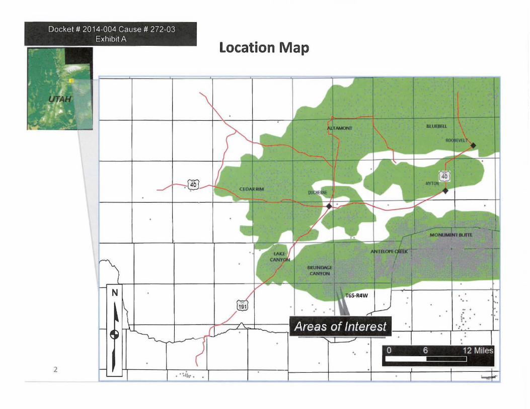
EXHIBIT "A" - Location Map.
EXHIBIT "B" - Geologic Setting.
EXHIBIT "c" - Diagrammatic Cross Section / AOI Map Section 24, TSS-RSW;
and Sections Sand 7, T6S-R4W.
EXHIBIT "D" - Well Summary Table.
EXHIBIT "E" - Brundage Canyon Section S T6S-R4W Production Graph Federal
02-0SD-64.
EXHIBIT "F" - Brundage Canyon T6S-R4W Green River I Wasatch Type Curve
Reserves and Volumetrics.
EXHIBIT "G" - Typical T6S-R4W Green River I Wasatch Reserves.
Due to the ongoing transition to a new entity and the unavailability of necessary
employees because of the holiday season, Berry is requesting this leave to fil e late
exhibits. For these reasons, Berry requests that this Motion be granted.
The hearing on this matter is scheduled [or January 22, 20 14. At this time, there
arc no adverse parties or any parties that have made an appearance in this matter.
DATED this 7th day of January, 2014.
BERRY PETROLEUM COMPANY
By: v\;vk L.. . ~f-A. John Davis Mark L. Burghardt Holland & Hart LLP 222 South Main Street, Suite 2200 Salt Lake City, UT 84101-2001 Telephone: (801) 799-5800
2

CERTIFICATE OF SERVICE
The undersigned hereby certifies that on this 7th day of January, 2014, a true and
correct copy of the foregoing MOTION FOR LEAVE TO FILE LATE EXHmITS
was mailed, postage prepaid, to the following:
United States of America c/o Bureau of Land Management Utah State Office 440 West 200 South, Suite 500 Salt lake City, Utah 84101
Michael S. Johnson, Esq. Assistant Attorney General Attorney for the Board of Oil, Gas and Mining 1594 West North Temple, Suite 300 P.O. Box 145801 Salt Lake City, Utah 84114-5801
United States of America '10 Ashley National Forest Supervisor's Office 355 North Vernal Ave. Vernal, UT 84078
The estate of Mary Alice Pendleton Poindexter 4805 Tacoma Blvd. Shreveport, LA 71107
Burlington Resources Oil & Gas Company, LP P.O. Box 51810 Midland, TX 7971 0
3
United States of America Bureau of Land Management Vernal Field Office 170 South 500 East Vernal, UT 84078
Steve Alder Assistant Attorney General Attorney for the Division of Oil, Gas and Mining 1594 West North Temple, Suite 300 P.O. Box 145801 Salt Lake City, Utah 84114-5801
Vintage Petroleum, Inc. State Federal Building 502 S. Main, Suite 400 Tulsa, OK 74103
Southland Energy Corp. 1710 Fourth National Bank Building 16 West 6th Street Tulsa, OK 74119
Donna A. Gillespie 11816 W. 65th Cir. Arvada, CO 80004
HEP Partners LP 500 W Illinois # 100 Midland, TX 7970 I
Enterprise Gas Company 2727 N. Loop West Houston, TX 77210
Talisman Oil & Gas Co. 5757 Alpha Rd., Suite 920 Dallas, TX 75240
Eagle Ridge Oil & Gas, Inc. 8517 S. 77th E. Place Tulsa, OK 74133
Mary Ann Allen 1513 Aylesbury Lane Plano, TX 75075
BurtonlHawks Inc. P.O. Box 359 Casper, WY 82602
T. Keith Marks 475 Capitol Life Center Denver, CO 80203
W.A. Gillespie 10708 Zuni Drive Westminster, CO 80234-3161
Jerry Leeman Allen 1513 Aylesbury Lane Plano, TX 75075
Respectfully submitted this 7th day of January, 2014.
BERRY PETROLEUM COMPANY
By: ~J~aVi~ 124= Mark L. Burghardt Holland & Hart LLP 222 South Main Street, Suite 2200 Salt Lake City, UT 84101-2001 Telephone: (801) 799-5800
4
Co
IV
:2: c o .-... IV
U
o
.....
•
. •
,' f
, • .r.: .
.'
z cr
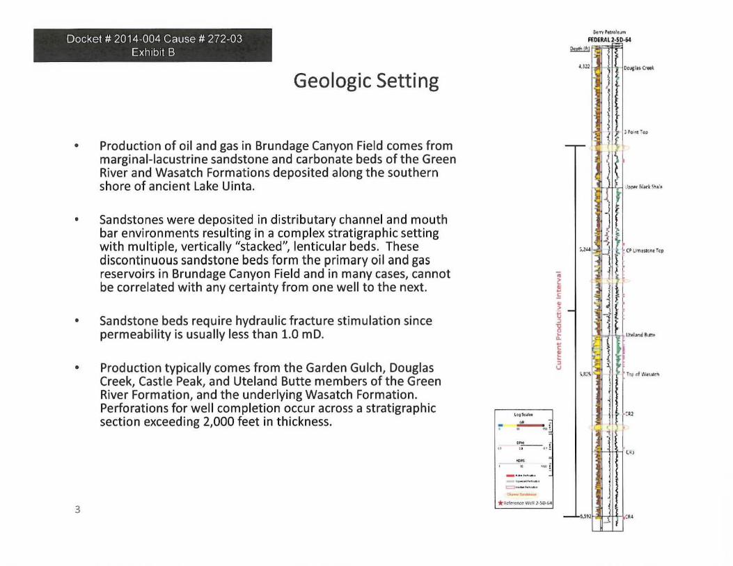
Docket # 2014-004 Cause # 272-03 Exhibit B
Geologic Setting
• Production of oil and gas in Brundage Canyon Field comes from marginal-lacustrine sandstone and carbonate beds of the Green River and Wasatch Formations deposited along the southern shore of ancient Lake Uinta.
• Sandstones were deposited in distributary channel and mouth bar environments resu lting in a complex stratigraphic setting with multiple, vertically "stacked", lenticu lar beds. These discontinuous sandstone beds form the primary oil and gas reservoirs in Brundage Canyon Field and in many cases, cannot be correlated with any certainty from one well to the next.
• Sandstone beds require hydraulic fracture stimulation since permeability is usually less than 1.0 mO.
• Production typically comes from the Garden Gulch, Douglas Creek, Castle Peak, and Uteland Butte members of the Green River Formation, and the underlying Wasatch Formation. Perforations for we ll completion occur across a stratigraphic section exceeding 2,000 feet in thickness.
3
.. -:- ~f
---- , .. , . !
-• -----
-,
*_""'~ w,~ 1·'U-f.<1
~ , ~ g ~ ~ ~ , v
a. ... f ..... i .....
-~
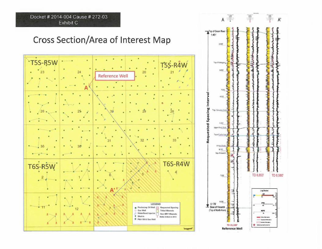
Docket # 2014-004 Cause # 272-03 Exhibit C
Cross Section/Area of Interest Map
• . 35 ,
· T6S-R5W • •
2 •
•
• 11
• !
• •
•
, ,
'"
• •
· -•
, . 12 , • •
•
31
- • ,
A'~ ,. • • '" '
" a. , A.--'( !It I ' ,
,,,1'.
1
, " ' j j~, ,' ....
,
•
• 32 33
"
, 5
• ,
T6S-R4W ~
• ,'\j
lEGEttO • _,,0.._ t:l ~_ ... --. -- 0 ..... _ ... W-·''' O _ ... y _ • _... a __ .....
• '"011 __
--
A =: , -1~ A'
,~·- .... t, 1.461"
,~
~
.. ·~v, ~j I ~lt-j~ ,a llfI
~ E i
,..
1 ' R
~ , ~ ,
C T"' {j,.,.....~ !H J+1 I ff • - ' ! '" 1-" ~ - -- ' j " .. '~ j i .JI-hj ~l
.. ,'--T"'~~'''''''
!~ r I ~ • c J]
'",--
p . ::
. m ~ S, 1l6" - _ Bneo!l...,..'dI -(Tt1'"Htc,~ - L _ .. __ ~ • .;o -. .•
TtlI5.lOII'
Reference Well
TO 6.653' TD658O'
-, ..
.. -. , ~!
";"-, ---" !
-• ... f
~-* --.... "
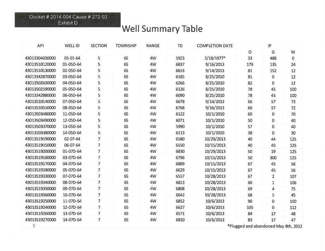
Docket # 2014-004 Cause # 272-03 Exhibit D
API WELl 10 SECTION
430133D4030000 05-01-64 5
43013510120000 01-050-64 5
43013510130000 02-050-64 5
43013342870000 03-050-64 5
43013502630000 04-050-64 5
43013502590000 05-050-64 5
43013342880000 06-050-64 5
43013510140000 07-050-64 5
43013510150000 08-050-64 5
43013503480000 11-050-64 5
43013503490000 12-050-64 5
43013503370000 13-050-64 5
430135033B1XXJO 14-050-64 5
43013519190000 02-07-64 7
430135191SOOOO 06-07-64 7
43013519200000 01-070-64 7
4301351916OODO 03-070-64 7
43013519170000 04-070-64 7
43013519180000 05-070-64 7
43013519330000 07-070-64 7
43013519340000 08-070-64 7
430135193SOOOO 09-070-64 7
4301351936OODO lG-070-64 7
43013519250000 11-070-64 7
43013519240000 12-070-64 7
4301351926OODO 13-070-64 7
43013519270000 14-070-64 7
5
Well Summary Table
TOWNSHIP RANGE TO COMPLETION DATE IP
0 G W
6S 4W 5923 2/ 18/ 1977' 33 488 0
6S 4W 6837 9/16/2013 179 135 24
6S 4W 6653 9/14/2013 81 152 12
6S 4W 6185 8/25/2010 81 0 12
65 4W 6266 8/25/2010 82 0 12
65 4W 6126 8/25/2010 78 45 100
65 4W 6090 8/25/2010 78 45 100
65 4W 6678 9/14/2013 66 57 73
65 4W 6768 9/16/2013 66 57 72 65 4W 6122 10/1/2010 60 0 70
65 4W 6071 10/1/2010 50 0 40
65 4W 5990 10/1/2010 57 0 40
65 4W 6113 10/1/2010 38 0 30
65 4W 6580 10/29/2013 40 44 125
6S 4W 6550 10/ 15/2013 40 45 125
6S 4W 6830 10/ 29/2013 50 19 125
6S 4W 6796 10/15/2013 50 300 125
6S 4W 6889 10/ 15/2013 67 45 56
65 4W 6629 10/15/2013 67 45 56
65 4W 6557 10/28/2013 67 2 107
65 4W 6813 10/28/2013 66 1 106
65 4W 6808 10/28/2013 69 4 75
65 4W 6642 10/28/2013 68 5 45
6S 4W 6852 10/6/2013 90 0 100
6S 4W 6627 10/6/2013 105 0 112
65 4W 6571 10/6/2013 84 17 48
65 4W 6810 10/6/2013 83 17 47
*Plugged and abandoned May 8th, 2012

Docket # 2014~004 Cause # 272 ~03
Exhibit E
m.
,,'I
Brundage Canyon Section 5 T6S-R4W Production Graph Federal 02-050-64
Federal 02~OSD~64 Reserves
.. 1 ... Reserves (EUR), MBO gross 50
Reserves (EUR), MMCF gross 165
Reserves (EUR), NGLgross 3 .5
....... ...... , .... . ...... . •.. .. • 1, " •.• .. , ~ .. -, ... _ !" ,. ' ~I " ... . ," ~~_ .. ~ " -: :.- er _ . Reserves (EUR) ." .--' . r . . ,- I '· ' ' MBO'
. , .... ,+ "''', ......... 1 ....... ···· 1 ... . · .. ·11
II.' I· · .. ··1· ........... ........ ... . ... .. +- li ;. . M\ ~=i<j,:~· A, . ,~ . > .. " .: ..•. :: •. :.: ........ : ..... . ... . .. ..................... . . I I ' f l '''' ~ lit i .... . .... .. .. II ... · .. · ......... · .... 1· .. ··:::·:::::::::j:::::::·:::::::::::::::+ :·::::1 :::""::: : ::.:: -::::::::: :-: :::::: : :, .. : ... , ..... ,. , .... J. " "":i. .. ... . •. • ..... _ . . . ~_ _
... + ·11 ....... .
~ II '.. ~ .. " I II ! Gii ,,", &: . ~lE - Ao; 1<~
::0 :1' 14

Docket # 2014-004 Cause # 272-03 Exhibit F
Brundage Canyon T6S-R4W Green River/Wasatch Type Curve Reserves and Volumetrics
120
100 \
80 \
Q \ a. w 60 \ 0
'" 40
20
o o 10
Green River/Wasatch Type Curve
Brundage Canyon T65 R4W Gree n River/Wasatch Type Curve
20
Reserves (EUR). MBO gross
Reserves (EUR), MMCF gross
Reserves {EUR), NGLgross
Reserves (EUR). MBDE gross
Well Ufe, yrs
D&C Costs, M$
Estimated OOIP (40 acres), MBO
Estimated Re<;overy Factor, %
Estimated Re(Overable Reserves, MBa
30
M onth
40 50
" 314
7
112
30
1232
1060
5
"
60
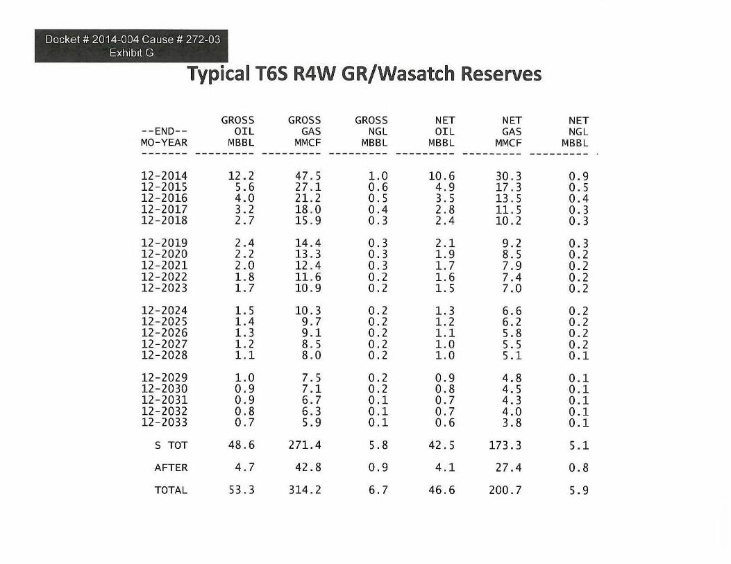
Docket # 2014-004 Cause # 272-03 Exhibit G
Typical T65 R4W GR/Wasatch Reserves
GROSS GROSS GROSS NET NET --END- - OIL GAS NGL OIL GAS MO-YEAR MBB L MMCF MBBL MBBL MMCF
NET NGL
MBBL ---- --- --------- --------- ---- ----- -- ------- ---- ---- - ---------
12 - 2014 12 . 2 47 . 5 1.0 10 . 6 30 . 3 0 . 9 12-2015 5. 6 27 .1 0 . 6 4 . 9 17 . 3 0 . 5 12-2016 4 . 0 21.2 0 . 5 3. 5 13 . 5 0 . 4 12-2017 3. 2 18 .0 0 .4 2 .8 11 . 5 0 . 3 12-2018 2.7 15 . 9 0 . 3 2 .4 10 . 2 0.3
12-2019 2 . 4 14 . 4 0 . 3 2. 1 9 . 2 0.3 12-2020 2 . 2 13 . 3 0.3 1.9 8. 5 0.2 12-2021 2 . 0 12 . 4 0 . 3 1.7 7. 9 0.2 12-2022 1.8 11 . 6 0 . 2 1.6 7. 4 0.2 12-2023 1.7 10 . 9 0 . 2 1.5 7. 0 0 . 2
12-2024 1.5 10 .3 0 . 2 1.3 6. 6 0.2 12-2025 1.4 9 . 7 0 . 2 1.2 6. 2 0 . 2 12-2026 1.3 9 .1 0 . 2 1.1 5. 8 0 . 2 12-2027 1.2 8 . 5 0 . 2 1.0 5. 5 0 . 2 12-2028 1.1 8 .0 0 . 2 1.0 5.1 0 . 1
12-2029 1.0 7. 5 0 . 2 0 . 9 4.8 0 . 1 12-2030 0 . 9 7.1 0 . 2 0 . 8 4.5 0.1 12-2031 0 . 9 6 . 7 0 .1 0 . 7 4.3 0 . 1 12-2032 0 .8 6.3 0 .1 0 . 7 4 . 0 0 . 1 12-2033 0 . 7 5.9 0 .1 0 . 6 3.8 0.1
STaT 48.6 271.4 5.8 42 . 5 173 . 3 5. 1
AFTER 4 . 7 42.8 0 . 9 4 .1 27 . 4 0 . 8
TOTAL 53 . 3 314 . 2 6 . 7 46 . 6 200 . 7 5. 9