EMERGENCY CALL-OUT FOR SLIDE LOCATED AT · PDF filelevel and pacing is shown on Figure ... as...
10
Continued.... 08\D:\15\76-13C.let November 23, 2001 File: 15-76-13 Alberta Transportation Room 301, Provincial Building 9621 - 96 Avenue Peace River, Alberta T8S 1T4 Attention: Mr. Ed Szmata EMERGENCY CALL-OUT FOR SLIDE LOCATED AT GUNN’S CREEK ON HWY 2A:54 9 KM EAST OF HWY 49 Dear Sir: This report presents the results of an emergency call-out for the above noted slide conducted by Mr. Don Proudfoot, P.Eng. of Thurber Engineering Ltd. on August 28, 2001. The request for the call-out was made by Mr. Ed Szmata of Alberta Transportation (AT) who was present during the visit along with Mr. Rafael Albino, P.Eng. of AT. 1. BACKGROUND The background history of the slide was discussed by phone with the area MCI Mr. Harold Ireland and Mr. Rodney Johnston and can be summarized as follows: • There was a slide in the south slope of the embankment fill in the 1980's (around 1989). The slide was a little bigger than the current one with the centre of the slide located a little further west than the current one. The backscarp of the slide extended to the white line of the south shoulder of the highway. • The following measures were carried out to repair the slide area: S The existing 2300 mm diameter CSP was extended an additional 17 m by adding a section of 2550 mm diameter CSP at an angle to follow the creek bed. The culvert was extended to allow an earth berm to be constructed at the base of the slope. S The failed slope area was re-graded to re-establish the slope.
Transcript of EMERGENCY CALL-OUT FOR SLIDE LOCATED AT · PDF filelevel and pacing is shown on Figure ... as...

Continued....08\D:\15\76-13C.let
November 23, 2001 File: 15-76-13
Alberta TransportationRoom 301, Provincial Building9621 - 96 AvenuePeace River, AlbertaT8S 1T4
Attention: Mr. Ed Szmata
EMERGENCY CALL-OUT FOR SLIDELOCATED AT GUNN’S CREEK ON HWY 2A:54
9 KM EAST OF HWY 49
Dear Sir:
This report presents the results of an emergency call-out for the above noted slideconducted by Mr. Don Proudfoot, P.Eng. of Thurber Engineering Ltd. on August 28,2001. The request for the call-out was made by Mr. Ed Szmata of AlbertaTransportation (AT) who was present during the visit along with Mr. Rafael Albino,P.Eng. of AT.
1. BACKGROUND
The background history of the slide was discussed by phone with the area MCI Mr.Harold Ireland and Mr. Rodney Johnston and can be summarized as follows:
• There was a slide in the south slope of the embankment fill in the 1980's(around 1989). The slide was a little bigger than the current one with thecentre of the slide located a little further west than the current one. Thebackscarp of the slide extended to the white line of the south shoulder of thehighway.
• The following measures were carried out to repair the slide area:
S The existing 2300 mm diameter CSP was extended an additional 17 mby adding a section of 2550 mm diameter CSP at an angle to follow thecreek bed. The culvert was extended to allow an earth berm to beconstructed at the base of the slope.
S The failed slope area was re-graded to re-establish the slope.

Alberta Transportation - 2 - November 23, 2001
Continued....08\D:\15\76-13C.let
S A herring bone system of gravel filled drainage trenches were installedthrough the slide area. The trenches were in the order of 2 m deep topenetrate below the slip surface of the slide.
S Left over multiplate sections were utilized to construct a half culvertsurface pipe to convey surface runoff from the low spot in the highwaydown the south slope of the embankment fill just east of the repairedslide area. The top end of the surface pipe was embedded below thepaved surface of the highway and a shallow cold mix asphalt curb wasplaced along the edge of the pavement to direct highway runoff into thesurface pipe.
S There were insufficient multiplate sections to reach the base of theslope, so the lower part of the drainage way was extended to the topof the 2550 mm diameter CSP outlet by constructing a shallow built upclay swale lined with geotextile. A gravel lined half culvert section wasused to form the outlet of the ditch which was located directly over theoutlet of the 2550 CSP.
S The repaired area was seeded.
• In 1997 the entire highway was overlaid during a highway paving program.
• The recent sliding event was first noticed in August of this year, which was thereason for contacting Thurber for the preliminary assessment.
2. OBSERVATIONS
2.1 August 28, 2001 Visit by Thurber
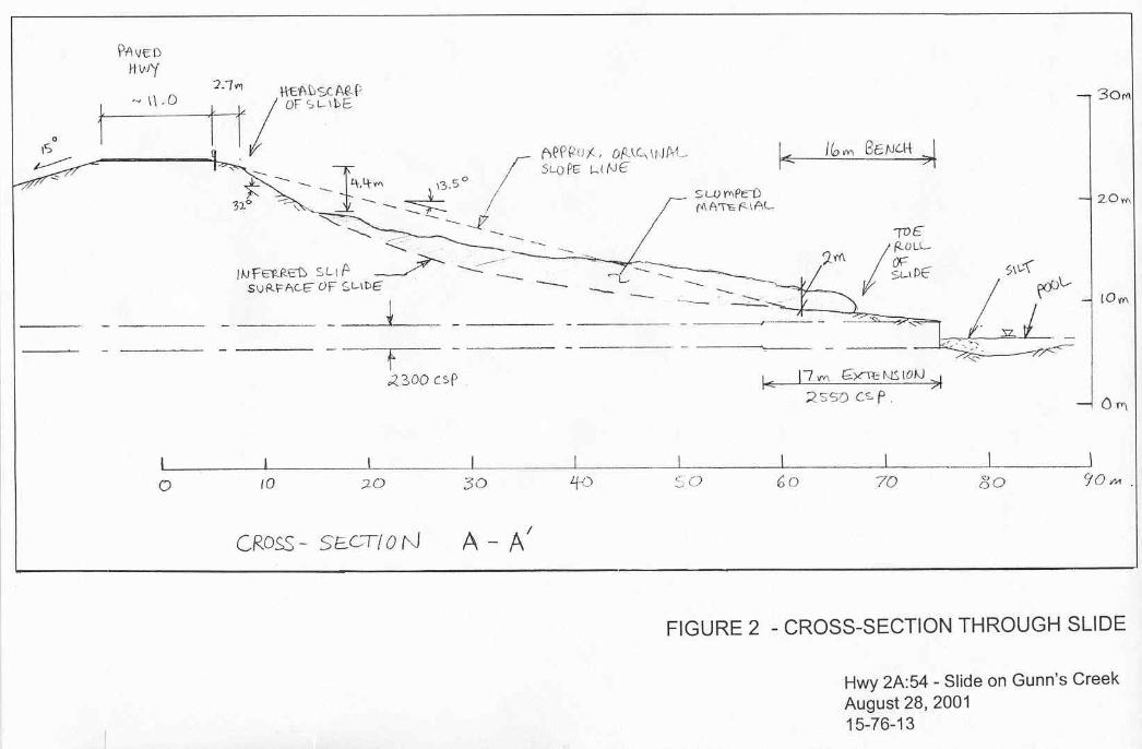
A sketch plan showing the extent of the slide on August 28, 2001 is provided onFigure 1 and a slope cross-section through the slide area as determined by handlevel and pacing is shown on Figure 2. Plan and cross-section views of the slide areaare also shown on Photographs #1,#2 and#3, attached.
The slide was located in the south facing slope of a 19 m high embankment fill overGunn’s Creek. The lower part of the slope was buttressed by a 3 to 4 m high bermwhich was about 16 m in width. The slide was present in the 15 m high 4H:1Vunsupported slope above the berm.
The slide varied from 25 to 20 m in width. The slumped material had dropped androtated to leave an exposed back scarp of 4 m in height offset 2.7 m from the edgeof the paved shoulder of the highway. The slumped material had run out onto theberm and the height of the toe roll was about 2m.

Alberta Transportation - 3 - November 23, 2001
Continued....08\D:\15\76-13C.let
Hairline cracks were noted in the paved surface of the road about 0.5 m from theedge of the shoulder, however, there were no obvious signs of distress in the guardrail. The cold mix asphalt curb that used to drain surface water from the road into thesurface pipe was no longer present leaving the opportunity for surface water to rundown over the slope area instead of being drained into the surface pipe. The slidemass had affected the surface pipe which was left unsupported over the back scarpof the slide and was pushed upwards and to the east in the lower part of the slope.The geotextile lined section of the drainage way was disturbed and/or covered by theslide material.
The inside of the culvert was inspected and found to be intact throughout its length.
The exposed soil in the slide area appears to consist mainly of high to medium plasticclay fill.
2.2 November, 2001 Update from AT
Recent inspections by Mr. Ireland and Mr. Johnston indicate that the slide conditionhas worsened since the August 28, 2001 visit by Thurber. It is understood that theback scarp of the slide is now located within about 1.5 m of the edge of pavement,the cracks in the pavement are now about 40 to 50 mm in width and the pavementhas dropped a bit on the slide side of the crack. There is also a noticeable bow in theguard rail.
3. PRELIMINARY ASSESSMENT
The original 19 m high slope inclined at 4H:1V was an unstable configuration whichfailed in about 1989. The berm constructed as part of the repairs provided someadditional support however, the revised 15 m unsupported height was still relativelyhigh for a 4H:1V embankment slope constructed out of high plastic clay fill material.The recent failure appears to have been of a progressive nature occurring about 11years after the previous repair of the slope area, due to gradual weakening of the clayfill by weathering processes consisting of freeze thaw and wetting and drying cycles.
The recent worsening of the site condition suggests that the slide area could continueto expand to the original limits of the 1989 slide event.
4. RISK LEVEL
In the short term there is some risk that the slide could continue to retrogress into theshoulder of the highway which could impact traffic safety and possibly cause partialclosure of the eastbound lane. However, the risk of total closure of both highwaylanes is relatively small.

Alberta Transportation - 4 - November 23, 2001
Continued....08\D:\15\76-13C.let
Based on AT’s criteria, the risk level for this slide is as follows:
Risk (40) = Probability Factor (10) * Consequence Factor (4)
The above rating is for an active slide with steady to slightly increasing rate ofmovement in a high embankment fill where partial closure of the highway could resultfrom further retrogression of the slide.
5. RECOMMENDATIONS
The slide is currently not affecting the use of the driving surface of the highway andgiven the current time of year and cold weather conditions it would not be practicalto carry out remedial measures at this time. It is anticipated that with the onset offreezing winter conditions, further significant slide retrogression is not expected tooccur until next spring. However, upon thawing the slide could continue to retrogressinto the roadway and pose a more serious risk to traffic safety.
The recommended short term action is to post slide area warning signs and for themaintenance people to continue monitoring the roadway and slide area on a weeklybasis through the winter period. If conditions worsen noticeably during this periodThurber should be contacted immediately to visit the site and provide further input.If the slide retrogresses further into the road appropriate barricades and additionalsigns should be provided as appropriate.
If the weather temporarily warms up this fall, or immediately in the spring the cold mixcurb should be re-instated to direct surface flows from the road into the surface pipeand to straighten out the surface pipe so that water is conveyed down the slope tothe berm and not through the current slide area.
Potential longer term solutions in order of increasing effectiveness (and cost) couldconsist of one of the following concepts:
• The minimum repair would consist of subexcavating the failed slide massdown to intact clay fill and rebuilding the slope with imported clay material. Thenew fill material should be placed and compacted in thin horizontal lifts,benched into the intact slope surface. The excavated material could be placedas a shallow berm at the toe of the slope on top of the existing berm surface.
• Subexcavate the failed slide mass to a deeper depth and rebuild the slopecomplete with a shear key using free draining pit run gravel.
• Extend the culvert to allow the width and height of the existing berm to beincreased and or/ the embankment slope to be flattened. The slide area wouldalso need to be subexcavated and replaced with imported clay or granular fill.

Alberta Transportation - 5 - November 23, 2001
08\D:\15\76-13C.let
For either of the above options, the topsoil would need to be stripped from the slopeand replaced upon completion and the repaired areas would need to be seeded. Thesurface drainage pipe would also need to be repaired and possibly extended to theoutlet of the culvert.
Ball park construction costs for the above measures could vary from about $150,000to $300,000.
6. ADDITIONAL INVESTIGATION AND DESIGN
Geotechnical drilling, site surveying and slope stability analyses will be recommendedto determine the required details of the above options and to provide the most costeffective design. It is recommended that this work be carried out through the wintermonths so that a design can be in place to expedite repairs in the spring of 2002.
7. CLOSURE
We trust that the above information is sufficient for your present requirements.However if you have any questions or require any additional input please do nothesitate to call us.
Yours very truly,Thurber Engineering Ltd.
Don Proudfoot, P.Eng.Review Engineer