Development Assessment Unit - The Hills Shire
93
Development Assessment Unit Tuesday, 01 March 2016 THE HILLS SHIRE COUNCIL
Transcript of Development Assessment Unit - The Hills Shire

Development Assessment
Unit
Tuesday, 01 March 2016
THE H
ILLS S
HIR
E C
OU
NC
IL

DEVELOPMENT ASSESSMENT UNIT MEETING 01 MARCH, 2016
ITEM SUBJECT PAGE
ITEM-1 CONFIRMATION OF MINUTES 3
ITEM-2 DA NO. 277/2015/HB - DEMOLITION OF
EXISTING STRUCTURES AND CONSTRUCTION OF
A MULTI DWELLING HOUSING DEVELOPMENT -
LOT 2 DP 503417 - 44 OLD CASTLE HILL ROAD,
CASTLE HILL
5
ITEM-3 DA NO. 396/2016/HA - EXISTING SHED TO BE
USED AS AN INDOOR RECREATION FACILITY
(TEENAGERS RETREAT, OFFICE, STUDIO AND
STORAGE) - LOT 9 DP 241639 - NO. 18 JOYLYN
ROAD, ANNANGROVE
49
ITEM-4 DA NO. 465/2016/LD - DEMOLITION OF
EXISTING STRUCTURES AND CONSTRUCTION OF
A TWO STOREY DWELLING, INGROUND
SWIMMING POOL AND RETAINING WALLS - LOT
453 DP 228905 - 7 SANDRINGHAM DRIVE,
CARLINGFORD
67

DEVELOPMENT ASSESSMENT UNIT MEETING 01 MARCH, 2016
MINUTES OF THE DEVELOPMENT ASSESSMENT UNIT MEETING HELD AT THE HILLS
SHIRE COUNCIL ON TUESDAY, 23 FEBRUARY 2016
PRESENT
Cameron McKenzie Group Manager – Environment & Planning (Chair)
Andrew Brooks Manager – Subdivision & Development Certification
Angelo Berios Acting Manager – Environment & Health
Craig Woods Manager – Regulatory Services
Bronwyn Smith Principal Forward Planner
Kristine McKenzie Principal Executive Planner
APOLOGIES
Mark Colburt Manager – Environment & Health
Paul Osborne Manager – Development Assessment
Stewart Seale Manager – Forward Planning
TIME OF COMMENCEMENT
8:30am
TIME OF COMPLETION
8:39am
ITEM-1 CONFIRMATION OF MINUTES
RESOLUTION
The Minutes of the Development Assessment Unit Meeting of Council held on 16 February
2016 be confirmed.
ITEM-2 DA NO. 1587/2014/HB - MULTI UNIT HOUSING
DEVELOPMENT CONTAINING 28 UNITS - LOT 46 DP
650442, RMB 57 WINDSOR ROAD, BAULKHAM HILLS
RESOLUTION
The Development Application be approved subject to the following conditions of consent.
DEFERRED COMMENCEMENT
Deferred Commencement – Registration of Easement
A1. Pursuant to Section 80(3) of the Environmental Planning and Assessment Act 1979
deferred commencement consent is granted subject to:

DEVELOPMENT ASSESSMENT UNIT MEETING 01 MARCH, 2016
1. The creation of a 5m wide (minimum) drainage easement over the downstream
properties, Lot 45 DP 215026, Lot 17 DP 1200327, SP 44999 and SP 67643. The
easement must extend north along the planned alignment of Stone Mason Drive
within Lot 45 DP 215026 and along the northern boundary of Lot 45 DP 215026
between Stone Mason Drive and Lot 17 DP 1200327, all the way to a legal point of
stormwater discharge, namely the natural watercourse within SP 44999 and SP
67643.
2. As the easement will drain stormwater runoff from a public road (Stone Mason
Drive); it must be an easement in gross in favour of Council. The total catchment
this easement will service includes 57, 59, 61, 63 and 65 Windsor Road as well as
Lot 17 DP 1200327.
3. The easement must not be created until the design of the associated stormwater
system, which will include both a piped and overland flow component according to
the minor/ major design criteria outlined in Council’s Design Guidelines for
Subdivision/ Development, has progressed to the stage that the location,
alignment, width and extent of the easement is known, as approved by Council’s
Manager – Subdivision and Development Certification, in consultation with the
affected property owners listed. The design criteria relating to these works are set
out under the condition entitled “engineering works and design” included later in
this consent.
4. The creation of a second 1.5m wide private/ inter-allotment drainage easement
along the western boundary of Lot 45 DP 215026 extending from the subject site
to the easement required to be created under point (1) above.
A2. The applicant must provide Council with written evidence demonstrating that the
matters listed under Part A1 above have been satisfactorily addressed no later than
four weeks before the notice of expiry date.
B. Upon compliance with the requirements of Part A1, a full consent will be issued
subject to conditions as set out in the report with the exception of Condition 34 which
is to be deleted.
END MINUTES

DEVELOPMENT ASSESSMENT UNIT MEETING 01 MARCH, 2016
PAGE 5
ITEM-2 DA NO. 277/2015/HB - DEMOLITION OF EXISTING
STRUCTURES AND CONSTRUCTION OF A MULTI
DWELLING HOUSING DEVELOPMENT - LOT 2 DP
503417 - 44 OLD CASTLE HILL ROAD, CASTLE HILL
THEME: Balanced Urban Growth
OUTCOME: 7 Responsible planning facilitates a desirable living
environment and meets growth targets.
STRATEGY:
7.2 Manage new and existing development with a robust
framework of policies, plans and processes that is in
accordance with community needs and expectations.
MEETING DATE: 1 MARCH 2016
DEVELOPMENT ASSESSMENT UNIT
AUTHOR: DEVELOPMENT ASSESSMENT CO-ORDINATOR
JAMES MCBRIDE
RESPONSIBLE OFFICER: MANAGER DEVELOPMENT ASSESSMENT
PAUL OSBORNE
The Development Application is for the demolition of existing structures and construction
of a multi-dwelling housing development comprising of seven dwellings with associated at-
grade car parking for 17 vehicles. The proposed multi-unit dwellings will be two storeys
(three of which will have underfloor parking) and comprise 2 x 4 bedroom and 5 x 3
bedroom dwellings.
The proposed development will rely upon vehicular access provided via a crossing to Old
Castle Hill Road with the exception of Townhouse 5 which will be reliant upon an existing
easement for a right of carriageway wholly located on the adjoining property known as No.
42 Old Castle Hill Road, Castle Hill. Part of the subject site being 44 Old Castle Hill Road
(Lot 2 DP 503417) benefits from an existing easement for a right of carriageway 6.1
metres wide located on the adjoining property known as 42 Old Castle Hill Road (Lot 13
DP 261440). The right of carriageway contains an existing driveway which is
approximately 3 metres wide. Given that the proposal will not require any physical works
to be carried out within the right of carriageway, the consent of the owner (Lot 13 DP
261440) is not required. Furthermore, legal advice has been submitted by the applicant
that indicates that townhouse 5 has entitlement to the right of carriageway and will have
the same entitlement in a future subdivision.
The proposal has been assessed against the relevant provisions of the Hills Development
Control Plan 2012 (DCP). Variations to the building envelope, finished floor levels,
landscaping, car parking design, common open space, private open space and front fence
design have been identified. The variations are addressed in the body of the report and
are considered to be satisfactory.
The Development Application was notified to adjoining properties and placed on public
exhibition for a period of 14 days on two separate occasions. In response, three
submissions were received during the first notification period and five submissions were
received during the second notification period. In summary, the submissions raised
concern with respect to the use of the right of carriageway, traffic, tree removal/retention,
privacy and amenity impacts associated with the proposed development. The issues raised
within the submissions are not considered to warrant further amendment or refusal of the
application.

DEVELOPMENT ASSESSMENT UNIT MEETING 01 MARCH, 2016
PAGE 6
The Development Application is recommended for approval subject to conditions of
consent.
BACKGROUND MANDATORY REQUIREMENTS
Applicant: Urban Link Pty Ltd 1. LEP 2012 – Permissible with
Consent.
Owner: Huasheng Austra
Pty Ltd
2. THDCP Part B, Section 4 – Multi
Dwelling Housing – Variations
proposed, see report.
Zoning: R3 Medium
Density Residential
3. Section 79C (EP&A Act) –
Satisfactory.
Area: 2,205.5m²
4. Section 94 Contribution -
$23,277.47
Existing Development: Two single
dwellings with
ancillary structures
SUBMISSIONS REASONS FOR REFERRAL TO DAU
1. Exhibition: Yes, fourteen (14)
days on two
separate
occasions.
1.
2.
Submissions Received.
Variations to the DCP.
2. Notice Adj Owners: Yes, fourteen (14)
days on two
separate
occasions.
3. Number Advised: 18 property
owners.
4. Submissions
Received:
Three (3)
submissions
received during
first exhibition
period and five (5)
submissions
received during
second exhibition
period.
POLITICAL DONATION – None disclosed

DEVELOPMENT ASSESSMENT UNIT MEETING 01 MARCH, 2016
PAGE 7
HISTORY
24/09/2012 Development Application No. 353/2013/HB lodged for the
demolition of existing structures and construction of 4 x 3
Bedroom Villas.
16/04/2013 Development Application No. 353/2013/HB for the demolition of
existing structures and construction of 4 x 3 Bedroom Villas
was refused by Council’s Development Assessment Unit. The
Application involved the site known as 44 Old Castle Hill Road,
Castle Hill and was refused on the basis of DCP non-
compliances in addition to the application not having owner’s
consent. The application involved physical works within the
adjoining right of way within 42 Old Castle Hill Road, Castle Hill
which did not have the consent of the adjoining land owner.
06/12/2013 Pre-lodgement meeting held at Council (89/2014/PRE) for Nos.
44 and 46A Old Castle Hill Road for the proposed development
of 8 townhouses.
28/08/2014 Subject Development Application lodged.
07/10/2014 The applicant was requested to submit additional information
relating to the consent of the adjoining property owner with
respect to the use of the right of way. Additionally, the
applicant was requested to submit amended plans pertaining to
issues identified with the design of the building envelope,
private open space, density, privacy, parking, landscaping and
engineering matters.
17/11/2014 The applicant was requested to provide a status update with
respect to the outstanding information.
24/12/2014 The applicant submitted concept plans accompanied by legal
advice to support the vehicular access arrangement via the
right of way located within the adjoining property. The concept
plans result in the deletion of one townhouse and an
amendment to the vehicular access to reduce the reliance on
the right of way to a single townhouse.
30/01/2015 The applicant was advised that the driveway within the right of
way was required to be extended to a minimum width of 5.5
metres requiring the consent of the adjoining land owner.
27/02/2015 The applicant requested clarification on the extent of works
required within the right of way and advised that an agreement
to carry out works within No. 42 Old Castle Hill Road, Castle Hill
was being negotiated with the land owner.
03/03/2015
Correspondence received from the owner of No. 42 Old Castle
Hill Road, Castle Hill raising concern that the proposed
development would impact upon the condition of the existing
right of way and that the intensification of the right of way
cannot be supported without their consent.

DEVELOPMENT ASSESSMENT UNIT MEETING 01 MARCH, 2016
PAGE 8
30/03/2015
Follow up email sent to the applicant with respect to the status
of obtaining owner’s consent from No. 42 Old Castle Hill Road,
Castle Hill.
05/05/2015 The applicant was provided 14 days to submit additional
information.
12/05/2015 The applicant submitted a concept plan demonstrating an
arrangement whereby works would not be required within the
adjoining right of way. The concept plan includes the provision
of a turning bay adjacent to the right of way.
12/05/2015 The applicant was advised that the concept plan may be
acceptable without the consent of No. 42 Old Castle Hill Road
provided that manoeuvring into Townhouse No. 5 could be
achieved within the existing right of way.
25/05/2015 The applicant requested an extension of time to submit
additional information.
16/06/2015 The applicant was provided 7 days to submit additional
information.
22/06/2015 Amended plans submitted by the applicant. The amendments
include the deletion of one townhouse, provision of a new
vehicular crossing to Old Castle Hill Road and other design
changes. It is noted that the consent of No. 42 Old Castle Hill
Road, Castle Hill is not provided.
02/07/2015 The Development Application was renotified for 14 days as a
result of amendments to vehicular access, the revised location
of the common open space area and the deletion of one
townhouse.
17/08/2015 The applicant was requested to submit additional information
relating to engineering matters relating to the driveway design.
04/09/2015 The applicant submitted a revised driveway design and traffic
statement.
11/09/2015 The applicant was requested to submit a revised sightline
analysis for internal traffic movements.
07/10/2015 The applicant submitted a revised driveway design and traffic
statement.
18/11/2015
The applicant was requested to submit amended plans in
relation to inconsistencies identified through the plan set. The
inconsistencies related to the driveway alignment.
08/12/2015 The applicant submitted amended plans.

DEVELOPMENT ASSESSMENT UNIT MEETING 01 MARCH, 2016
PAGE 9
21/12/2015 The applicant was requested to provide further legal advice in
relation to the use of the right of carriageway and the status of
the right of carriageway in the event that the site is subdivided
under a Strata scheme.
23/12/2015
The applicant submitted further legal advice.
SITE AND SURROUNDS
The subject site has a frontage of 33.7 metres and an area of 2,205m2. The site slopes
away from Old Castle Hill Road with a fall of approximately 7.5 metres from the north-east
corner to the north-west corner.
Part of the subject site being 44 Old Castle Hill Road (Lot 2 DP 503417) benefits from an
easement for a right of carriageway 6.1 metres wide located on the adjoining property
known as 42 Old Castle Hill Road (Lot 13 DP 261440).
The subject site is adjoined by single dwellings to the north, east and south and Old Castle
Hill Road to the west. The area is characterised by a mix of low and medium density
housing. The subject site is not located within the Castle Hill North Precinct however is
bounded by properties on the opposite side of Old Castle Hill that are located within the
precinct. It is noted that the precinct boundary is located two properties to the south of
the subject site.
THE PROPOSAL
The Development Application is for the demolition of existing structures and construction
of a multi-dwelling housing development comprising of seven dwellings with associated at-
grade car parking comprising of 17 spaces. The proposed multi-unit dwellings will be two
storeys and comprise 2 x 4 bedroom and 5 x 3 bedroom dwellings.
The proposed built form will comprise of attached two storey dwellings in three separate
groups. Three dwellings are located parallel to the frontage of Old Castle Hill Road and will
have underfloor parking using the topography of the land. Two dwellings are located
parallel to the rear boundary and will have at-grade parking within an attached garage.
The remaining two dwellings are located parallel to an existing right of carriageway that is
located within the adjoining property to the south. Proposed townhouse no. 5 will rely
upon vehicular access to the right of carriageway with the remaining dwellings accessing
Old Castle Hill Road from a driveway directly to Old Castle Hill Road.
Private open space and ground floor living areas are orientated to the north-east.
Townhouses 1-3 will have elevated private open space areas which are screened by
horizontal privacy slats to a height of 1.8 metres. The common open space area is located
to the rear of the site and will contain a children’s play area. Pedestrian access is provided
adjacent to the proposed driveway.
Townhouse No. 1 is proposed to be an adaptable dwelling and is capable of compliance
with the Building Code of Australia, Premises Standard and applicable Australian
Standards as outlined in the submitted access report prepared by Accessible Building
Solutions.

DEVELOPMENT ASSESSMENT UNIT MEETING 01 MARCH, 2016
PAGE 10
The proposed building materials for the dwellings include masonry brick and two tone
painted cement render. The roof will comprise of concrete tiles whilst the front and
courtyard fences will be masonry with vertical timber slats.
The proposed landscape scheme will include planting along the boundary interfaces of the
development including the front setback and adjacent to the internal driveway. Retaining
walls are proposed along sections of the northern and eastern boundaries with a maximum
height of 800mm. The proposal includes the removal of 14 trees and the retention of 5
trees.
The proposed stormwater management of the site will involve the discharge of stormwater
to an underground on-site detention system with overflow to be directed to an existing
drainage easement which discharges downstream to Heatherbrae Place.
It is noted that the proposal was amended during the course of assessment to delete one
dwelling and to provide independent vehicular access to the site. The original proposal was
fully reliant upon the existing right of carriageway within the adjoining property for
vehicular access.
ISSUES FOR CONSIDERATION
1. The Hills Local Environmental Plan 2012
Pursuant to The Hills Local Environmental Plan 2012 (LEP), the subject site is zoned R3
Medium Density Residential. This type of development is categorised as “multi dwelling
housing” under the LEP which is defined as follows:
“multi dwelling housing means 3 or more dwellings (whether attached or detached) on one
lot of land, each with access at ground level, but does not include a residential flat
building.”
Under the provisions of the LEP, multi dwelling housing is permissible in the R3 Medium
Density Residential zone.
The maximum building height permitted for the site under Clause 4.3 of the LEP is 9
metres. The maximum proposed height is 9 metres to the roof ridgeline of townhouse 3.
Clause 4.4 of the LEP does not impose a maximum floor space ratio (FSR) for the site,
therefore, the scale of the development is limited by the density requirements of DCP Part
B Section 4 – Multi Dwelling Housing.
Clause 6.2 requires that development consent must not be granted unless the Council is
satisfied that public utilities are available for future development. In this regard, a
condition will be recommended to be imposed requiring a certificate from each service
authority stating that they are satisfied that services have been provided to their
requirements.
The proposed development is considered to be satisfactory with respect to the relevant
provisions of the LEP.
2. The Hills Development Control Plan 2012
The proposed development has been assessed against the relevant development
standards and objectives of THDCP Part B, Section 4 – Multi Dwelling Housing. The
following variations are proposed:-

DEVELOPMENT ASSESSMENT UNIT MEETING 01 MARCH, 2016
PAGE 11
Development
Standard
THDCP Part B Section 4
Requirements
PROPOSED COMPLIES
3.1 Site
requirements
(c) Battle-axe access
driveway - Prohibited
The proposal is
partially reliant upon
an existing battle-axe
driveway located
within Lot 13 DP
261440 (42 Old Castle
Hill Road, Castle Hill).
No – Refer to
Section 2(a) of
this report.
3.3 Setbacks
Building
Alignment
2nd storey component –
6m
Second storey to
townhouse 5 is 5.7
metres.
No – Refer to
Section 2(b) of
this report.
3.4 Building
Heights
Developments on sloping
sites are to be stepped so
that the floor level of
habitable rooms does not
exceed one metre above
or below natural ground
level when measured at
any point on the ground
floor.
Given the provision of
underfloor parking, the
finished floor level of
townhouse 1, 2 and 3
will be more than 1
metre above natural
ground level.
No – Refer to
Section 2(c) of
this report.
3.6 Building
Separation and
Driveway
Treatment
Where a unit fronts the
driveway a 2m wide
landscape area must be
provided between the unit
and the driveway (except
where entrance and
garages are located).
Min. 2m wide landscape
area between the
driveway and any
adjoining property
boundary.
Two metres of
landscaping not
provided adjacent to
turning bay and main
driveway.
No – Refer to
Section 2(d) of
this report.
3.7 Landscaped
Area
Minimum of 50% of the
site exclusive of access
driveways and parking.
1073 square metres of
landscaped area
provided. This equates
to 48% of the site
area.
No – Refer to
Section 2(e) of
this report.

DEVELOPMENT ASSESSMENT UNIT MEETING 01 MARCH, 2016
PAGE 12
3.12 Open
Space
A. Private open space:
- One continuous area of
private open space equal
to 50% of the floor area
of the dwelling shall be
provided for each
dwelling.
- Private open space
areas are to be
contiguous to the dwelling
for which it is provided
and have a minimum
useable area of 5m x 5m.
B. Common open space:
- Common open space
areas comprising a
children’s play area shall
be provided on the site
behind the building line,
for developments of more
than five (5) dwellings.
- The common open
space is to be centrally
located and regularly
shaped and must meet
the following criteria:
5 or less units – Not
required
6 – 14 units - min.
144m2 with min. 12m x
12m dimensions
15 or more units - 10m2
per unit with minimum
dimension of 12m
The private open
space areas are not
continuous.
Private open space
areas are contiguous
to the dwelling
however townhouse 3
does not provide for a
minimum useable area
of 5m x 5m.
The proposed common
open space area will
comprise an area of
132 square metres
and will not meet the
dimension
requirements of 12m x
12m.
No – Refer to
Section 2(f) of
this report.
No – Refer to
Section 2(f) of
this report.
No – Refer to
Section 2(g) of
this report.
3.25 Fencing
All fencing/walls fronting
a street to be setback a
minimum 2 metres from
the boundary to permit
landscaping. These fences
shall include recesses and
other architectural
features.
The front fence is
setback 800mm from
Old Castle Hill Road.
No – Refer to
Section 2(h) of
this report.

DEVELOPMENT ASSESSMENT UNIT MEETING 01 MARCH, 2016
PAGE 13
a) Site Requirements – Access
Section 3.1 of the DCP restricts access to a multi dwelling housing development from a
Battle-axe driveway. The proposal is partly reliant upon an existing battle-axe driveway
located within Lot 13 DP 261440 (42 Old Castle Hill Road, Castle Hill). Proposed
townhouse 5 will solely rely upon vehicular access via an existing easement for a right of
carriageway which is in the form of a battle-axe handle.
The objective of the control is to ensure that a development site has sufficient areas to
provide adequate access, parking, landscaping and building separation. In this instance,
the proposed development will provide for a dual access arrangement to Old Castle Hill
Road via an existing right of carriageway and driveway. The use of the adjoining right of
carriageway is considered to be satisfactory given that it will only facilitate access for
townhouse 5 and will not require physical upgrade given the provision of a passing bay
within the subject site. Access to townhouse 5 would be difficult in any other design
scenario given the topography of the site. Utilising the right of carriageway is considered
to be appropriate as it will not intensify the use of the right of carriageway and will
facilitate vehicle movements for townhouse 5 which would be comparable to the existing
situation. Furthermore, the majority of vehicular movements for the proposed
development will be accommodated via the proposed driveway which will also facilitate
access for visitors. In this regard, a variation to the control is considered to be
satisfactory.
b) Building Setback – Second Storey
Section 3.3 of the DCP prescribes that a second storey component be set back 6 metres
from any side and rear property boundary. Proposed townhouse 5 will be set back 5.7
metres from the property boundary.
The objective of the control is to enhance and protect the privacy and amenity of adjoining
properties. The non-compliance of 300mm is the result of a point encroachment which
occurs to a bedroom on the first floor. The point encroachment relates to the provision of
a window that protrudes 300mm from the primary building line. In this instance, the
protrusion of the window provides for articulation of the second storey which is consistent
with the prevailing design theme of the development. With respect to privacy, the window
will have a sill height of 1.2 metres and will service a bedroom. Given the low traffic use of
the bedroom, it is considered that the proposed encroachment of the window will not
present undue opportunities to overlook into adjoining properties. In this regard, a
variation to the control is considered to be satisfactory.
c) Building Heights – Finished Floor Level
Section 3.4 of the DCP prescribes that developments on sloping sites are to be stepped so
that the floor level of habitable rooms do not exceed one metre above or below natural
ground level when measured at any point on the ground floor. The proposed finished floor
levels of townhouses 1, 2, 3 and 7 exceed one metre above natural ground level. The
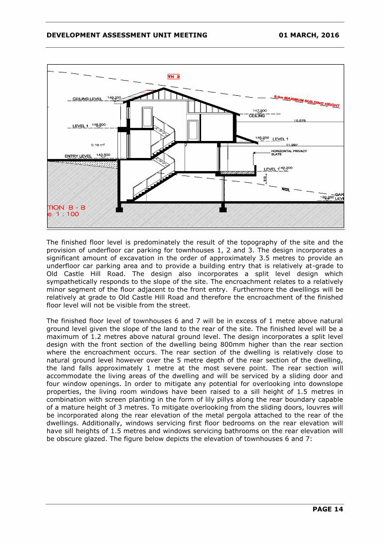
section plan below depicts the protrusion of the finished floor level of townhouse 2 which
details the finished floor level being approximately 1.3 metres above natural ground level.
DEVELOPMENT ASSESSMENT UNIT MEETING 01 MARCH, 2016
PAGE 14
The finished floor level is predominately the result of the topography of the site and the
provision of underfloor car parking for townhouses 1, 2 and 3. The design incorporates a
significant amount of excavation in the order of approximately 3.5 metres to provide an
underfloor car parking area and to provide a building entry that is relatively at-grade to
Old Castle Hill Road. The design also incorporates a split level design which
sympathetically responds to the slope of the site. The encroachment relates to a relatively
minor segment of the floor adjacent to the front entry. Furthermore the dwellings will be
relatively at grade to Old Castle Hill Road and therefore the encroachment of the finished
floor level will not be visible from the street.
The finished floor level of townhouses 6 and 7 will be in excess of 1 metre above natural
ground level given the slope of the land to the rear of the site. The finished level will be a
maximum of 1.2 metres above natural ground level. The design incorporates a split level
design with the front section of the dwelling being 800mm higher than the rear section
where the encroachment occurs. The rear section of the dwelling is relatively close to
natural ground level however over the 5 metre depth of the rear section of the dwelling,
the land falls approximately 1 metre at the most severe point. The rear section will
accommodate the living areas of the dwelling and will be serviced by a sliding door and
four window openings. In order to mitigate any potential for overlooking into downslope
properties, the living room windows have been raised to a sill height of 1.5 metres in
combination with screen planting in the form of lily pillys along the rear boundary capable
of a mature height of 3 metres. To mitigate overlooking from the sliding doors, louvres will
be incorporated along the rear elevation of the metal pergola attached to the rear of the
dwellings. Additionally, windows servicing first floor bedrooms on the rear elevation will
have sill heights of 1.5 metres and windows servicing bathrooms on the rear elevation will
be obscure glazed. The figure below depicts the elevation of townhouses 6 and 7:

DEVELOPMENT ASSESSMENT UNIT MEETING 01 MARCH, 2016
PAGE 15
The proposed encroachments will not result in a breach to the overall building height nor
will it result in unacceptable amenity impacts associated with privacy and solar access. In
this regard, given the responsive nature of the design in relation to the topography of the
site and the privacy measures proposed to mitigate any adverse impacts, the proposed
variation to the finished floor levels are considered to be satisfactory.
d) Landscape Setback
Section 3.6 of the DCP prescribes that where a unit fronts the driveway a 2 metre wide
landscape area must be provided between the unit and the driveway (except where
entrance and garages are located). Furthermore, the DCP also prescribes that a minimum
2 metre wide landscape area be provided between the driveway and any adjoining
property boundary.
A small section of townhouses 3 and 4 do not provide a 2 metre wide landscaped area
adjacent to dwellings. Whilst landscaping is provided adjacent to the dwelling and the
driveway, the width does not achieve the 2 metre requirement. In this instance, a
variation is considered to be satisfactory as the variation occurs at a point in the driveway
that is not visible from the street. In relation to amenity, the section of the dwelling
adjoining the driveway will not contain any ground floor window openings immediately
adjacent to the driveway. Furthermore, given the topography of the site in addition to the
alignment and width of the driveway, compliance with the control would result in a
significant amendment to the design. In this regard a variation is considered to be
satisfactory and worth of support.
The main driveway servicing the site will not accommodate a 2 metre wide landscape area
adjacent to the property boundary of Lot 13 DP 261440 (42 Old Northern Road, Castle
Hill). Instead, a landscape strip varying in width between 300mm to 600mm is proposed
adjacent to the existing right of carriageway. In this instance a variation is considered to
be satisfactory as the driveway location is predicated on the topography of the site and
the driveway alignment will accommodate safe vehicle movements into and out of the site.
Alternatively, relocating the driveway to the other side of the property would result in the
removal of significant street trees and would substantially compromise the current layout
of the development. Furthermore, shifting the driveway towards the north to
accommodate a 2 metre wide landscaped area would further compromise the private open
space area for townhouse 3 and would create an undesirable vehicle crossing to Old Castle

DEVELOPMENT ASSESSMENT UNIT MEETING 01 MARCH, 2016
PAGE 16
Hill Road. It is also noted that the existing right of way abuts the subject site with no
landscaping buffer. The proposed development will include landscaping between the
driveway and right of carriageway and will soften the impact of the driveway from the
street.
In this regard, a variation to the control is considered to be satisfactory.
e) Landscaped Area
Section 3.7 of the DCP prescribes that a minimum area of 50% of the site exclusive of
access driveways and parking be provided for landscaping. The proposed development will
provide a landscaped area of 1073 square metres which equates to 48% of the site area.
The proposed variation represents a shortfall of 29 square metres.
The proposed development is accessed via a common driveway to service garages
provided at grade. Given the topography of the site, basement parking would not be
feasible. Thus, in order to provide vehicular access, a common driveway is proposed which
comprises of an extensive footprint. The driveway provides for vehicular access to the
development however contributes to the shortfall of landscaped area. Whilst the shortfall
is relatively minor, the proposal does provide for a communal open space area and will
achieve a deep soil zone of 44% of the site area which exceeds the minimum deep soil
zone requirement of 30%. Furthermore, the proposed landscape scheme will result in the
embellishment of landscaping on site, particularly along the boundary interfaces to the
north, east and west.
In this regard, given the constraints of the site with respect to providing adequate
vehicular access in response to the topography of the site and the embellishment of
landscaping, a variation is considered to be satisfactory.
f) Private Open Space
Section 3.12 of the DCP requires that one continuous area of private open space equal to
50% of the floor area of the dwelling be provided for each dwelling. It is noted that the
proposed development contains dwellings that do not provide a continuous area of private
open space that is equal to 50% of the floor area of the respective dwelling. The proposed
private open space areas achieve compliance by combining segregated areas located to
the front and rear of the dwelling with respect to Townhouses 2, 3 and 6.
Additionally, townhouses 3 and 4 do not provide the required 50% of the floor area of the
dwelling for private open space. Townhouse 3 provides 60 square metres of private open
space where 69 square metres is required. Townhouse 4 provides 45 square metres of
private open space where 67 square metres is required. It is noted that all other dwellings
exceed the minimum required private open space area.
The proposed private open space areas for townhouses 2 and 3 utilise the front setback
area in addition to an elevated area to the rear of the dwellings for private open space.
Further, townhouse 6 will utilise the rear setback area in addition to a small area at the
front of the dwelling. It is noted that the DCP does not restrict the use of the front setback
area for the purposes of private open space. In this instance the private open space areas
within the front setback will be screened by landscaping in addition to being secured by a
masonry fence with timber slats. Whilst the private open space area is not continuous, the
combination of both areas is considered to be satisfactory given that the private open
space will provide a direct extension of the living space for the enjoyment of residents.
The two areas will also provide for different recreational functions which will promote both
active and passive uses. Additionally, it should be noted that the private open space area
will receive adequate solar access pursuant to the DCP.

DEVELOPMENT ASSESSMENT UNIT MEETING 01 MARCH, 2016
PAGE 17
With respect to the shortfall of private open space for townhouses 3 and 4, the respective
private open spaces areas will provide for a direct outdoor extension to the living areas
and will promote passive recreational uses. The proposed development provides for a
common open space area which is centrally located and contains children’s play equipment
which is suitable for active recreational uses. The common open space area is immediately
adjacent to townhouses 3 and 4. Additionally, whilst the area falls short of the minimum
requirement, the quality of the private open space area with respect to the attainment of
solar access should be considered given the northerly orientation of the respective areas.
In this regard, townhouses 3 and 4 achieve solar access complying with the DCP.
Given the above, a variation to the private open space requirements is considered to be
satisfactory.
g) Common Open Space
The primary common open space area equates to 132 square metres which falls short of
the requirement for 144 square metres. Further, the minimum dimension requirement of
12 by 12 metres is not provided. It is noted that a secondary common open space area is
provided adjacent to the northern boundary which equates to 63 square metres and is
accessed from the central driveway.
The objective of the control is to provide a functional open space area within the
development for the informal recreation of residents and children play. The primary area
will be centrally located and will be accessed from the main driveway. The area will
contain two types of children play equipment including a slide and rope climber which will
provide for active recreational use. Additionally, the area will be surrounded with
landscaping around the perimeter to enhance the space and will also include bench
seating. The common open space area is considered to provide for an area that is
commensurate with the objectives of the DCP.
Furthermore, it is noted that a secondary area for common open space is provided
adjacent to the northern boundary which would provide for a combined area of 199 square
metres of common open space for the site.
In this regard, a variation to the control is considered to be satisfactory and worth of
support.
h) Front Fencing
Section 3.25 of the DCP requires all fencing fronting a street to be setback a minimum 2
metres from the boundary to permit landscaping. The proposed front fence is set back
800mm from the front property boundary to Old Castle Hill Road.
The front fence will be designed of painted brick render with horizontal infill timber slats to
a height of 1.8 metres. The fence will be recessed to a depth of 2.2 metres for a segment
of the fence adjacent to the entries for townhouse 1 and 2. Landscaping is proposed within
the 800mm setback forward of the fence to soften the appearance of the fence from the
street. The depth of landscaping is capable of sustaining the proposed landscape
plantings. In this regard, given that open style design of the fence and that landscaping is
proposed forward of the fence, a variation is considered to be satisfactory and is worth of
support.
3. Issues Raised in Submissions
The Development Application was notified to adjoining properties and placed on public
exhibition for a period of 14 days on two separate occasions. In response, three
submissions were received during the first exhibition period and five submissions were
received during the second exhibition period. The issues raised within these received
submissions are addressed below:-

DEVELOPMENT ASSESSMENT UNIT MEETING 01 MARCH, 2016
PAGE 18
ISSUE/OBJECTION COMMENT OUTCOME
Concern is raised that the
existing right of
carriageway cannot be used
without the consent of Lot
13 DP 261440.
Part of the subject site being 44
Old Castle Hill Road (Lot 2 DP
503417) benefits from an
easement for a right of carriageway
6.1 metres wide located on the
adjoining property known as 42 Old
Castle Hill Road (Lot 13 DP
261440). The right of carriageway
contains an existing driveway
which is approximately 3 metres
wide. It is noted that the remaining
part of the subject site being 46A
Old Castle Hill Road (Lot 142 DP
776783) is not a beneficiary to the
right of carriageway.
The original plans included access
via the right of carriageway for six
of the eight townhouses proposed.
The proposal was amended to
address concerns raised by Council
staff with respect to the use of the
right of carriageway. The original
proposal was not supported on the
basis that physical works to the
right of way was required and that
the consent of the servient
tenement of the right of
carriageway had not been
obtained. Additionally, concern was
raised that proposed townhouses
within the subject site that were
outside the curtilage of Lot 2 DP
503417 were not legally entitled to
the right of carriageway, unless the
consent of the owner was provided
to include Lot 142 DP 776783 as a
beneficiary to the right of
carriageway.
Accordingly, the proposal was
amended to relinquish access to
the right of way for townhouses
within the curtilage of Lot 142 DP
776783. However, proposed
townhouse 5 is reliant on the right
of carriageway for access and is
wholly located within the curtilage
of Lot 2 DP 503417.
The amended plans have been
reviewed and Council’s
Issue addressed.

DEVELOPMENT ASSESSMENT UNIT MEETING 01 MARCH, 2016
PAGE 19
ISSUE/OBJECTION COMMENT OUTCOME
Development Engineer has
indicated that the use of the right
of carriageway would not require
any physical upgrade given that a
passing bay was provided within
the subject site. Furthermore,
manoeuvring for townhouse 5 can
be achieved within the existing 3
metre wide driveway.
In this regard, the consent of Lot
13 DP 261440 is not required.
Concern is raised that the
proposed development will
intensify the right of
carriageway beyond that
permitted by the title.
Proposed townhouse 5 is reliant on
the right of carriageway for access
and is wholly located within the
curtilage of Lot 2 DP 503417 which
is a beneficiary to a right of
carriageway located within Lot 13
DP 261440.
The applicant has provided legal
advice indicating that townhouse 5
being located wholly within Lot 2
DP 503417 has the right to use the
right of carriageway.
With respect to intensification,
townhouse 5 being a single
dwelling will contain a double
garage. Vehicle movements
expected from a single dwelling will
not significantly intensify the use of
the right of carriageway beyond
that of the existing situation. Lot 2
DP 503417 currently contains a
single dwelling. It is considered
that the proposed use of the right
of carriageway would be
comparable to the existing
situation.
Accordingly, the right of way will
not be intensified beyond that
permitted by the easement.
Issue addressed.

DEVELOPMENT ASSESSMENT UNIT MEETING 01 MARCH, 2016
PAGE 20
Concern is raised that the
right of way will be
extended to all of the
townhouses given that they
share the same strata title.
The proposal was amended to
relinquish access to the right of
way for townhouses within the
curtilage of Lot 142 DP 776783.
However, proposed townhouse 5 is
reliant on the right of carriageway
for access and is wholly located
within the curtilage of Lot 2 DP
503417.
The applicant has provided legal
advice indicating that Townhouse 5
being located wholly within Lot 2
DP 503417 has the right to use the
right of carriageway. The legal
advice also indicates that under a
plan of consolidation of Lot 2 DP
503417 and Lot 142 DP 776783,
the consolidated lot to be created
would have the benefit of the right
of carriageway to the extent that
Lot 2 DP 50341 had the benefit of
the right of carriageway.
On this basis, a condition of
consent is recommended to ensure
that townhouse 5 is identified
within the Deposited Plan as the
sole beneficiary of the existing
right of carriageway and not the
entire consolidated site.
In this regard, in the event of a
future subdivision, the benefit of
the right of carriageway will not be
extended to the entire
development site.
Issue addressed.
The existing boundary fence
adjacent to the right of way
cannot be removed without
the consent of Lot 13 DP
261440. Without owner’s
consent, the fence cannot
be removed and access to
the site would not be
possible.
The proposal would require an
existing boundary fence adjacent
to the right of carriageway to be
removed in order to provide access
to townhouse 5.
In this regard, any negotiations
regarding the removal of the fence
are to be carried out with the
respective land owners as a civil
matter in accordance with the
Dividing Fences Act 1991.
Issue addressed.

DEVELOPMENT ASSESSMENT UNIT MEETING 01 MARCH, 2016
PAGE 21
Concern is raised that the
use of the right of way
would affect the safety of
pedestrians given the
existing pavement width of
3 metres.
The use of the right of way will not
be significantly intensified when
compared with the existing
situation. Nevertheless,
pedestrians and motorists should
take due care whilst travelling
along the driveway. To improve the
potential for vehicle conflict, a
passing bay has been provided
within the development site.
Issue addressed.
Concern is raised that
vehicles from the
development site will use
the existing right of way
instead of the proposed
vehicular driveway.
The proposed vehicular crossing
would allow for all vehicle
movements including visitors to
access the main driveway within
the development site with the
exception of townhouse 5. In this
regard, there is no requirement for
any other of the townhouses to use
the right of carriageway.
Nevertheless, a condition of
consent is recommended which will
restrict access to the right of
carriageway to townhouse 5.
Issue addressed.
The existing right of way is
heavily landscaped along
the southern side. The
existing landscaping should
remain intact to protect the
privacy of adjoining
neighbours.
The proposed development will not
involve any physical works within
the right of carriageway. Therefore,
the proposed landscaping on the
southern side of the right of
carriageway will be unaffected by
the proposed development.
Issue addressed.
Concern is raised in relation
to the outcomes of the
Traffic Report in particular
the finding that the
proposal will result in a net
increase of three vehicle
trips per hour.
The traffic report prepared by
Varga Traffic Planning applies the
RMS traffic generation rates to the
proposal which results in an overall
net increase of an additional 3 peak
hour trips. Council’s Principal
Coordinator Traffic has reviewed
the proposal and concurs with the
assumptions of the traffic report.
Issue addressed.
Concern is raised that the
proposed development
would impact upon the local
traffic network.
Council’s Principal Coordinator
Traffic has reviewed the proposal
and has raised no objection from a
traffic viewpoint as the additional
traffic will have negligible impact
on the efficiency or safety of the
surrounding road network.
Issue addressed.

DEVELOPMENT ASSESSMENT UNIT MEETING 01 MARCH, 2016
PAGE 22
The proposed vehicle
movements along the right
of way will impact upon the
amenity of the immediate
property to the south.
Townhouse 5 being a single
dwelling will contain a double
garage. Vehicle movements
expected from a single dwelling will
not significantly intensify the use of
the right of carriageway beyond
that of the existing situation. Lot 2
DP 503417 currently contains a
single dwelling. It is considered
that the proposed use of the right
of carriageway would be
comparable to the existing
situation.
The proposed development will not
involve any physical works within
the right of carriageway. Therefore,
the proposed landscaping on the
southern side of the right of
carriageway will be unaffected by
the proposed development.
Based on the above, the use of the
right of carriageway will not result
in adverse impacts upon the
amenity of adjoining properties.
Concern is raised in relation
to the demolition of the
existing structures with
respect to hazardous
materials. Formal
notification should be
provided to adjoining
properties prior to
demolition.
A condition of consent is
recommended to ensure that any
hazardous materials including
asbestos be removed by a licensed
contractor in accordance with NSW
Workcover Authority requirements.
Additionally, notice must be given
to Council and neighbouring
properties at least 5 days prior to
demolition work commencing.
Issued addressed.
Refer to condition
33.
Concern is raised that the
proposal is an
overdevelopment of the site
and should be refused as
per the outcomes of
DA353/2013/HB.
The proposed development is
considered to respond to the
controls and objectives for multi
dwelling housing development as
envisaged by Council’s
Development Control Plan.
The proposed development is
required to comply with a
maximum density requirement.
The maximum density for the
development site based on its area
is 20.95 persons (the equivalent of
95 persons per hectare). The
proposed development provides for
20.5 people which is below the
maximum density requirement.
Issued addressed.

DEVELOPMENT ASSESSMENT UNIT MEETING 01 MARCH, 2016
PAGE 23
The development provides a
reasonable interface to adjoining
properties with respect to the
building envelope and is
embellished with suitable
landscaping within and along the
edges of the site.
Concern is raised with
respect to the townhouses
located adjacent to the rear
boundary. The dwellings
should be designed at
natural ground level and not
be elevated.
The finished floor level of
townhouse 6 and 7 will be in
excess of 1 metre above natural
ground level given the slope of the
land to the rear of the site. The
finished level will be a maximum of
1.2 metres above natural ground
level.
The design incorporates a split
level design with the front section
of the dwelling being 800mm
higher than the rear section where
the encroachment occurs. The rear
section of the dwelling is relatively
at-grade to natural ground level
however over the 5 metre depth of
the rear section of the dwelling, the
land falls approximately 1 metre at
the most severe point. The rear
section will accommodate the living
areas of the dwelling and will be
serviced by a sliding door and four
window openings.
In order to mitigate any potential
for overlooking into downslope
properties, the living room
windows have been raised to a sill
height of 1.5 metres in
combination with screen planting in
the form of lily pillys along the rear
boundary capable of a mature
height of 3 metres. Additionally, to
mitigate overlooking from the
sliding doors, louvres will be
incorporated along the rear
elevation of the metal pergola
attached to the rear of the
dwellings. Additionally, windows
servicing first floor bedrooms on
the rear elevation will have sill
height of 1.5 metres and windows
servicing bathrooms on the rear
elevation will be obscure glazed.
Issue addressed.

DEVELOPMENT ASSESSMENT UNIT MEETING 01 MARCH, 2016
PAGE 24
In this regard, given the site
constraints and the design
incorporating measures to mitigate
the impacts of overlooking, the
proposed development will not
cause undue privacy impacts to
downslope properties.
Concern is raised in relation
to overlooking from the
townhouses located to the
rear of the site. The
windows should be treated
with a sill height of 1.5
metres.
The proposed windows servicing
the ground and first floor of
townhouse 6 and 7 will be raised to
a sill height of 1.5 metres along the
rear elevation to mitigate any
potential for overlooking.
Issue addressed.
Concern is raised in relation
to the retention of a bunya
pine located adjacent to the
rear boundary within the
subject site. The tree drops
large pine nuts which cause
damage to surrounding
properties. The tree should
be removed.
The bunya pine located adjacent to
the rear boundary is proposed to
be retained as detailed on the
plans. However, Council’s Tree
Management Officer has reviewed
the proposal and has
recommended the tree be removed
as part of the proposed
development. Accordingly, a
condition of consent has been
recommended to reflect this
requirement.
Issue addressed.
Refer to condition 7.
The south facing aspect of
townhouse 6 will impact the
privacy of adjoining
properties.
Townhouse 6 is west facing and
does not immediately adjoin the
existing right of carriageway to the
south. It is noted that townhouses
4 and 5 have a southerly
orientation being adjacent to the
right of carriageway.
It is considered that the proposed
development as a whole has been
designed with regard to protecting
the amenity of adjoining
properties. The proposed
placement of living rooms with
respect to orientation maximises
the privacy of adjoining properties
and will not result in undue
overlooking. Additionally, where
the finished floor level provides a
potential platform, window
treatments in addition to
landscaping have been
incorporated to offset any potential
impact.
Issue addressed.

DEVELOPMENT ASSESSMENT UNIT MEETING 01 MARCH, 2016
PAGE 25
ENGINEERING COMMENTS
Council’s Development Engineer has assessed the proposal and raised no objection subject
to conditions.
TREE MANAGEMENT COMMENTS
Council’s Tree Management Officer has assessed the proposal and raised no objection
subject to conditions.
TRAFFIC COMMENTS
Council’s Principle Coordinator Traffic has assessed the proposal and raised no objection
subject to conditions.
RESOURCE RECOVERY
Council’s Resource Recovery Project Officer has assessed the proposal and raised no
objection subject to conditions.
CONCLUSION
This application has been evaluated in accordance with Section 79C of the Environmental
Planning and Assessment Act 1979 and against the Land and Environment Court’s ‘criteria
for the assessment of impacts on neighbouring properties’ and is considered satisfactory.
Variations to The Hills Development Control Plan 2012 are proposed and have been
addressed in this report.
It is considered that the application is worthy of support. The concerns raised in the
submission received do not warrant further amendment or refusal of the application.
IMPACTS
Financial
This matter has no direct financial impact upon Council's adopted budget or forward
estimates.
The Hills Future Community Strategic Plan
The proposed development is consistent with the planning principles, vision and objectives
outlined within “Hills 2026 – Looking Towards the Future” as the proposed development
provides for satisfactory growth without adverse environmental or social amenity impacts.
The social and environmental impacts have been identified and addressed in the
report. The proposal provides a satisfactory design that does not compromise the
character of the locality and the Shire as a whole.
The proposal represents balanced urban growth, and the proposed medium density
residential development will complement the nature of the site. The proposal fits within
the context of the site and is considered to be consistent with the long-term direction and
goals for the locality.

DEVELOPMENT ASSESSMENT UNIT MEETING 01 MARCH, 2016
PAGE 26
RECOMMENDATION
The application be approved subject to the following conditions of consent.
GENERAL MATTERS
1. Development in Accordance with Submitted Plans
The development being carried out in accordance with the following approved plans and
details, stamped and returned with this consent except where amended by other
conditions of consent.
REFERENCED PLANS AND DOCUMENTS
DRAWING NO. DESCRIPTION REVISION DATE
01 Cover Page prepared by Urban Link F 05/02/2016
02 Site Plan Analysis prepared by Urban
Link
F 05/02/2016
03 Site Plan prepared by Urban Link F 05/02/2016
04 Lower Ground Floor Plan prepared by
Urban Link
F 05/02/2016
05 Ground Floor Plan prepared by Urban
Link
F 05/02/2016
06 First Floor Plan prepared by Urban Link F 05/02/2016
07 Sections prepared by Urban Link F 05/02/2016
08 Elevations prepared by Urban Link F 05/02/2016
09 Elevations prepared by Urban Link F 05/02/2016
15 Schedule of Finishes prepared by Urban
Link
F 05/02/2016
Sheet 1 Proposed Landscape Plan prepared by
discount landscape plans
C 14/08/2014
Sheet 2 Proposed Landscape Plan prepared by
discount landscape plans
C 14/08/2014
No work (including excavation, land fill or earth reshaping) shall be undertaken prior to
the issue of the Construction Certificate, where a Construction Certificate is required.
2. Building Work to be in Accordance with BCA
All building work must be carried out in accordance with the provisions of the Building
Code of Australia.
3. Construction Certificate
Prior to construction of the approved development, it is necessary to obtain a Construction
Certificate. A Construction Certificate may be issued by Council or an Accredited Certifier.
Plans submitted with the Construction Certificate are to be amended to incorporate the
conditions of the Development Consent.
4. Study and Media Room must not be converted
The proposed study and media rooms within the development are not to be converted into
bedrooms without the prior approval of Council.

DEVELOPMENT ASSESSMENT UNIT MEETING 01 MARCH, 2016
PAGE 27
5. Adherence to Waste Management Plan
All requirements of the Waste Management Plan submitted to and approved by Council
must be implemented during the construction and/ or demolition phases of the
development, as well as the ongoing management phase. The information submitted can
change provided that the same or a greater level of reuse and recycling is achieved as
detailed in the plan. Any material moved offsite is to be transported in accordance with
the requirements of the Protection of the Environment Operations Act 1997 and only to a
place that can lawfully be used as a waste facility. Receipts of all waste/ recycling tipping
must be kept onsite at all times and produced in a legible form to any authorised officer of
the Council who asks to see them.
6. Property Numbering for Integrated Housing, Multi Unit Housing, Commercial
Developments and Industrial Developments
The responsibility for property numbering is vested solely in Council.
The property address for this development is: - TH 1-7/44 Old Castle Hill Road Castle Hill
Unit numbering is as per plans submitted – numbered 05 and dated 17 September 2015.
These numbers, unless otherwise approved by Council in writing, are to be displayed
clearly on all buildings/door entrances.
Clear and accurate external directional signage is to be erected on site at driveway entry
points and on buildings. Unit numbering signage is also required on stairway access doors
and lobby entry doors. It is essential that all numbering signage throughout the complex
is clear to assist emergency service providers locate a destination with ease and speed.
7. Tree Removal
Approval is granted for the removal of trees 1, 2, and 4-15 inclusive as shown in tree plan
in arborist report prepared by Redgum Horticultural dated 4 August 2014.
All other trees are to remain and are to be protected during all works. Suitable
replacement trees are to be planted upon completion of construction.
8. Retention of Trees
Trees 3, 16, and 20-22 are to be retained with remedial work to be carried out in
accordance with the Arborist report by Redgum Horticultural dated 4 August 2014.
9. Management of Construction and/ or Demolition Waste
Waste materials must be appropriately stored and secured within a designated waste area
onsite at all times, prior to its reuse onsite or being sent offsite. This includes waste
materials such as paper and containers which must not litter the site or leave the site onto
neighbouring public or private property. A separate dedicated bin must be provided onsite
by the builder for the disposal of waste materials such as paper, containers and food
scraps generated by all workers. Building waste containers are not permitted to be placed
on public property at any time unless a separate application is approved by Council to
locate a building waste container in a public place. Any material moved offsite is to be
transported in accordance with the requirements of the Protection of the Environment
Operations Act 1997 and only to a place that can lawfully be used as a waste facility. The
separation and recycling of the following waste materials is required: metals, timber,
masonry products and clean waste plasterboard. This can be achieved by source
separation onsite, that is, a bin for metal waste, a bin for timber, a bin for bricks and so
on. Alternatively, mixed waste may be stored in one or more bins and sent to a waste
contractor or transfer/ sorting station that will sort the waste on their premises for
recycling. Receipts of all waste/ recycling tipping must be kept onsite at all times and
produced in a legible form to any authorised officer of the Council who asks to see them
10. Surplus Excavated Material
The disposal of surplus excavated material, other than to a licenced waste facility, is not
permitted without the formal approval of Council prior to works commencing onsite. Any
unauthorized disposal of waste, which includes excavated material, is a breach of the

DEVELOPMENT ASSESSMENT UNIT MEETING 01 MARCH, 2016
PAGE 28
Protection of the Environment Operations Act 1997 and subject to substantial penalties.
Receipts of all waste/ recycling tipping must be kept onsite at all times and produced in a
legible form to any authorised officer of the Council who asks to see them.
11. Commencement of Domestic Waste Service
The home owners or agent acting for the owners must ensure to arrange the
commencement of a domestic waste service with Council. The service is to be arranged no
earlier than two days prior to occupancy and no later than two days after occupancy of a
unit. All requirements of Council’s domestic collection service must be complied with at all
times. Please telephone Council on (02) 9843 0310 for the commencement of waste
services.
12. Provision of Domestic Waste Storage Area (Units 1-5)
Sufficient space must be allocated within the private open space area of each unit to store
a minimum of two 240 litre mobile bins (for waste streams as determined by Council). The
location is required to ensure that the bins are not visible from any adjoining property or
public place and allow the bins to be wheeled to the street over flat or ramped surfaces,
grade not to exceed 1:14, and not over steps, kerbs, landscape edging or through a
habitable area of the dwelling.
13. Construction of Communal Waste Storage Area (Units 6-8)
The communal waste storage area is required to comprise of three separate dedicated bin
cupboards. Each cupboard must be sized to store a minimum of two 240 litre mobile bins.
They must be fully enclosed and have separate keys and locking systems. The design
must also ensure that the bins are not visible from any adjoining property or public place.
Finishes and colours of the bin cupboards are to compliment the design of the
development. Note the dimensions of a 240 litre mobile bin are: 735mm (d), 580mm (w)
and 1080mm (h).
14. Separate Application for Strata Subdivision
A separate application must be submitted for any proposed strata titled subdivision of the
approved development.
15. Protection of Public Infrastructure
Council must be notified of any damage to public infrastructure caused by the
development. Adequate protection must be provided prior to work commencing and
maintained during building operations. Any damage caused must be made good, to the
satisfaction of Council, before an Occupation Certificate can be issued. Public infrastructure
includes the road pavement, kerb and gutter, concrete footpaths, drainage structures,
utilities and landscaping fronting the site.
16. Structures Adjacent to Piped Drainage Easements
Buildings and structures, including footings and brick fences, adjacent to existing or
proposed drainage easements must be located wholly outside the easement. A design
must be provided by a structural engineer certifying that the structure will not impart a
load on the pipe in the easement.
17. Vehicular Access and Parking
The formation, surfacing and drainage of all driveways, parking modules, circulation
roadways and ramps are required, with their design and construction complying with:
a) AS/ NZS 2890.1
b) AS/ NZS 2890.6
c) AS 2890.2
d) Council’s DCP Part C Section 1 – Parking
e) Council’s Driveway Specifications
Where conflict exists the Australian Standard must be used.
The following must be provided:

DEVELOPMENT ASSESSMENT UNIT MEETING 01 MARCH, 2016
PAGE 29
i. All passing bays are to be configured as per AS2890.1. Passing bays are to be
provided as per the ‘Traffic and Parking Matters’ statement by Varga Traffic
Planning dated 7 October 2015 and the drawings which form appendices to such
document.
ii. All driveways and car parking areas must be prominently and permanently line
marked, signposted and maintained to ensure entry and exit is in a forward
direction at all times and that parking and traffic circulation is appropriately
controlled.
iii. All driveways and car parking areas must be separated from landscaped areas by a
low level concrete kerb or wall.
iv. All driveways and car parking areas must be concrete or bitumen. The design must
consider the largest design service vehicle expected to enter the site. In rural
areas, all driveways and car parking areas must provide for a formed all weather
finish.
v. All driveways and car parking areas must be graded, collected and drained by pits
and pipes to a suitable point of legal discharge.
18. Gutter and Footpath Crossing Application
Each driveway requires the lodgement of a separate gutter and footpath crossing
application, accompanied by the applicable fee as per Council’s Schedule of Fees and
Charges.
19. Minor Engineering Works
The design and construction of the engineering works listed below must be provided for in
accordance with the following documents and requirements:
a) Council’s Design Guidelines Subdivisions/ Developments
b) Council’s Works Specifications Subdivisions/ Developments
Any variance from these documents requires separate approval from Council.
Works on existing public roads or any other land under the care and control of Council
must be approved and inspected by Council in accordance with the Roads Act 1993 or the
Local Government Act 1993. A separate minor engineering works application and
inspection fee is payable as per Council’s Schedule of Fees and Charges.
i. Driveway Requirements
The design, finish, gradient and location of all driveway crossings must comply with the
above documents and Council’s Driveway Specifications.
- The proposed driveways must be built to Council’s medium duty standard.
A separate driveway application fee is payable as per Council’s Schedule of Fees and
Charges.
ii. Disused Layback/ Driveway Removal
All disused laybacks and driveways must be removed and replaced with kerb and gutter
together with the restoration and turfing of the adjoining footpath verge area.
iii. Site Stormwater Drainage
The entire site area must be graded, collected and drained by pits and pipes to a suitable
point of legal discharge.
iv. Earthworks/ Site Regrading
Earthworks are limited to that shown on the approved plans. Where earthworks are not
shown on the approved plan the topsoil within lots must not be disturbed.
DEVELOPMENT ASSESSMENT UNIT MEETING 01 MARCH, 2016
PAGE 30
v. Service Conduits
Service conduits to each of the proposed new lots, laid in strict accordance with the
relevant service authority’s requirements, are required. Services must be shown on the
engineering drawings.
vi. Stormwater Drainage – Pipe Extension
A new kerb inlet pit must be provided at the end of the existing easement, fronting 3
Heatherbrae Place and the street drainage extended from the existing pit downstream.
The pipe extension must be located under the existing kerb requiring the removal and
reconstruction of the kerb and gutter and road shoulder.
20. External Finishes
External finishes and colours shall be in accordance with the details submitted with the
development application and approved with this consent.
21. Commencement of Domestic Waste Service
The property owner or agent acting for the owner must ensure to arrange the
commencement of a domestic waste service with Council. The service is to be arranged no
earlier than two days prior to occupancy and no later than two days after occupancy of the
development. All requirements of Council’s domestic collection service must be complied
with at all times. Please telephone Council on (02) 9843 0310 for the commencement of
waste services.
PRIOR TO THE ISSUE OF A CONSTRUCTION CERTIFICATE
22. Section 94 Contribution
The following monetary contributions must be paid to Council in accordance with Section
94 of the Environmental Planning and Assessment Act, 1979, to provide for the increased
demand for public amenities and services resulting from the development.
Payments comprise of the following:-
The contributions above are applicable at the time this consent was issued. Please be
aware that Section 94 contributions are updated quarterly.
Prior to payment of the above contributions, the applicant is advised to contact Council’s
Development Contributions Officer on 9843 0268. Payment must be made by cheque or
credit/debit card. Cash payments will not be accepted.
This condition has been imposed in accordance with Contributions Plan No 5.
Council’s Contributions Plans can be viewed at www.thehills.nsw.gov.au or a copy may be
inspected or purchased at Council’s Administration Centre.
23. Security Bond Requirements
A security bond may be submitted in lieu of a cash bond. The security bond must:
Purpose: 3
bedroom unit
Purpose: 4
bedroom unitPurpose: Credit
No. of 3 bedroom
units: 5
No. of 4 bedroom
units: 2Sum of Units No. of Credits: 2 Total S94
Roads & Traffic - Land 9.40$ 12.18$ 12.18$ 47.00$ 24.36$ 71.36$ 24.36$ 47.00$
Roads & Traffic - Capital 349.66$ 453.25$ 453.25$ 1,748.30$ 906.50$ 2,654.80$ 906.50$ 1,748.30$
Open Space - Land 2,353.75$ 3,051.15$ 3,051.15$ 11,768.75$ 6,102.30$ 17,871.05$ 6,102.30$ 11,768.75$
Open Space - Capital 606.98$ 786.79$ 786.79$ 3,034.90$ 1,573.58$ 4,608.48$ 1,573.58$ 3,034.90$
Community Facilities - Land 43.09$ 55.86$ 55.86$ 215.45$ 111.72$ 327.17$ 111.72$ 215.45$
Community Facilities - Capital 1,282.20$ 1,662.01$ 1,662.01$ 6,411.00$ 3,324.02$ 9,735.02$ 3,324.02$ 6,411.00$
Total 4,645.08$ 6,021.24$ 6,021.24$ 23,225.40$ 12,042.48$ 35,267.88$ 12,042.48$ 23,225.40$
DEVELOPMENT ASSESSMENT UNIT MEETING 01 MARCH, 2016
PAGE 31
a) Be in favour of The Hills Shire Council;
b) Be issued by a financial institution or other accredited underwriter approved by, and
in a format acceptable to, Council (for example, a bank guarantee or unconditional
insurance undertaking);
c) Have no expiry date;
d) Reference the development application, condition and matter to which it relates;
e) Be equal to the amount required to be paid in accordance with the relevant
condition;
f) Be itemised, if a single security bond is used for multiple items.
Should Council need to uplift the security bond, notice in writing will be forwarded to the
applicant 14 days prior.
24. Sediment and Erosion Control Plan
A sediment and erosion control plan prepared in accordance with Council’s Works
Specification Subdivision/ Developments must be submitted. The plan must include:
a) Allotment boundaries;
b) Adjoining roads;
c) Contours;
d) Existing vegetation;
e) Existing site drainage;
f) Critical natural areas;
g) Location of stockpiles;
h) Erosion control practices;
i) Sediment control practices; and
j) A maintenance program for the erosion and sediment controls.
25. Onsite Stormwater Detention – Hawkesbury River Catchment Area
Onsite Stormwater Detention (OSD) is required in accordance with Council’s adopted
policy for the Hawkesbury River catchment area, the Upper Parramatta River Catchment
Trust OSD Handbook, with amended parameters for the site storage requirement and
permissible site discharge.
The stormwater concept plan prepared by Loka Consulting Engineers Drawings D00 to D05
Revisions A/B/B/C/A/A (respectively) is for development application purposes only and is
not to be used for construction. The detailed design must reflect the approved concept
plan and the following necessary changes:
a) Concrete benching is required to the invert level of the orifice plate in the OSD tank.
Comprehensive design plans showing full construction details must be prepared by an
accredited OSD designer and submitted with:
- A completed OSD Drainage Design Summary Sheet;
- Drainage calculations and details, including those for all weirs, overland flow paths and
diversion (catch) drains, catchment areas, times of concentration and estimated peak
run-off volumes;
- A completed OSD Detailed Design Checklist;
- A maintenance schedule.
The design and construction of the OSD system must be approved by either Council or an
accredited certifier. This certification must be included with the documentation approved
as part of any Construction Certificate.

DEVELOPMENT ASSESSMENT UNIT MEETING 01 MARCH, 2016
PAGE 32
A Design Compliance Certificate (DCC) certifying the detailed design of the OSD system
can be issued by Council subject to the following being provided:
i. A completed application form;
ii. Four copies of the design plans and specifications;
iii. Payment of the applicable application and inspection fees.
26. Works in Existing Easement
All adjoining properties either benefited or burdened by the existing easement must be
notified of the proposed works within the easement in writing, including commencement
and completion dates, before a Construction Certificate is issued.
27. Draft Legal Documents
Where an encumbrance on title is required to be created as part of this consent, draft
copies of all legal documents must be submitted to Council for checking before a
Construction Certificate is issued.
28. Security Bond – Road Pavement and Public Asset Protection
In accordance with Section 80A(6)(a) of the Environmental Planning and Assessment Act
1979, a security bond of $103,275.00 is required to be submitted to Council to guarantee
the protection of the road pavement and other public assets in the vicinity of the site
during construction works. The above amount is calculated at the rate of $85.00 per
square metre based on the road frontage of the subject site plus an additional 50m on
either side (total 135m) multiplied by the width of the road (9m).
The bond must be lodged with Council before a Construction Certificate is issued.
The bond is refundable upon written application to Council and is subject to all work being
restored to Council’s satisfaction. Should the cost of restoring any damage exceed the
value of the bond, Council will undertake the works and issue an invoice for the recovery
of these costs.
29. Security Bond – External Works
In accordance with Section 80A(6)(b) of the Environmental Planning and Assessment Act
1979, a security bond is required to be submitted to Council to guarantee the
construction, completion and performance of all works external to the site. The bonded
amount must be based on 150% of the tendered value of providing all such works. The
minimum bond amount is $10,000.00. The bond amount must be confirmed with Council
prior to payment.
The works which this bond relate to are listed below:
- Extension of public drainage infrastructure
The bond must be lodged with Council before a Construction Certificate is issued.
The bond is refundable upon written application to Council and is subject to all work being
completed to Council’s satisfaction.
PRIOR TO WORK COMMENCING ON THE SITE
30. Tree Protection Signage
Prior to any works commencing on site a Tree Protection Zone sign must be attached to
the Tree Protection Fencing stating “Tree Protection Zone No Access” (The lettering size on
the sign shall comply with AS1319). Access to this area can only be authorised by the
project arborist or site manager.
31. Tree Protection Fencing
Prior to any works commencing on site Tree Protection Fencing must be in place around
trees or groups of trees nominated for retention. In order of precedence the location of

DEVELOPMENT ASSESSMENT UNIT MEETING 01 MARCH, 2016
PAGE 33
fencing shall be a) As per Tree Protection Plan as per Arborist report for project or b) Tree
Protection Zone (TPZ) as calculated under AS4970 (2009) Protection of trees on
development sites c) A minimum of 3m radius from trunk.
The erection of a minimum 1.8m chain-wire fence to delineate the TPZ is to stop the
following occurring:
Stockpiling of materials within TPZ;
Placement of fill within TPZ;
Parking of vehicles within the TPZ;
Compaction of soil within the TPZ;
Cement washout and other chemical or fuel contaminants within TPZ; and
Damage to tree crown.
32. Mulching within Tree Protection Zone
Prior to any works commencing on site all areas within the Tree Protection Zone are to be
mulched with composted leaf mulch to a depth of 100mm.
33. Demolition Works and Asbestos Management
The demolition of any structure is to be carried out in accordance with the Work Health
and Safety Act 2011. All vehicles transporting demolition materials offsite are to have
covered loads and are not to track any soil or waste materials on the road. Should
demolition works obstruct or inconvenience pedestrian or vehicular traffic on adjoining
public road or reserve, a separate application is to be made to Council to enclose the
public place with a hoard or fence. All demolition works involving the removal and disposal
of asbestos (of an area more than 10 square metres) must only be undertaken by a
licenced asbestos removalist who is licenced to carry out the work. Asbestos removal must
be carried out in accordance with the WorkCover, Environment Protection Authority and
Office of Environment and Heritage requirements. Asbestos to be disposed of must only be
transported to waste facilities licenced to accept asbestos. No asbestos products are to be
reused on the site.
34. Discontinuation of Domestic Waste Services
Council provides a domestic waste service to the property subject to this Development
Application. This service must be cancelled prior to demolition of the existing dwelling or
where the site ceases to be occupied during works, whichever comes first. You will
continue to be charged where this is not done. No bins provided as part of the domestic
waste service are to remain on site for use by construction workers, unless previous
written approval is obtained from Council. To satisfy this condition, the Principal Certifying
Authority must contact Council on (02) 9843 0310 at the required time mentioned above
to arrange for the service to be discontinued and for any bins to be removed from the
property by Council.
35. Traffic Control Plan
A Traffic Control Plan is required to be prepared and submitted to Council for approval.
The person preparing the plan must have the relevant accreditation to do so. Where
amendments to the plan are required post approval, they must be submitted to Council for
further approval prior to being implemented.
A plan that includes full (detour) or partial (temporary traffic signals) width road closure
requires separate specific approval from Council. Sufficient time should be allowed for this
to occur.
36. Sediment and Erosion Control
The approved sediment and erosion control measures, including a stabilised all weather
access point, must be in place prior to works commencing and maintained during
construction and until the site is stabilised to ensure their effectiveness. For major works,

DEVELOPMENT ASSESSMENT UNIT MEETING 01 MARCH, 2016
PAGE 34
these measures must be maintained for a minimum period of six months following the
completion of all works.
37. Service Authority Consultation
Before works commence:
a) Documentary evidence must be submitted confirming that satisfactory arrangements
have been made for the relocation, undergrounding and/ or provision of electrical
services for the non-residue lots created by the subdivision.
b) Documentary evidence, including a notice of requirements from Sydney Water, must
be submitted confirming that satisfactory arrangements have been made for the
provision of water and sewerage facilities.
c) Consultation with the relevant telecommunications provider authorised under the
Telecommunications Act regarding the installation of telephone conduits is required.
The design and construction of these works must comply with current NBN standards,
where applicable.
38. Separate OSD Detailed Design Approval
No work is to commence until a detailed design for the OSD system has been approved by
either Council or an accredited certifier.
39. Sydney Water building plan approval
A building plan approval must be obtained from Sydney Water Tap in™ to ensure that the
approved development will not impact Sydney Water infrastructure. A copy of the building plan approval receipt from Sydney Water Tap in™ must be
submitted to the Principal Certifying Authority upon request prior to works commencing.
Please refer to the website http://www.sydneywater.com.au/tapin/index.htm , Sydney
Water Tap in™, or telephone 13 20 92.
40. Management of Building Sites – Builder’s Details
The erection of suitable fencing or other measures to restrict public access to the site and
building works, materials or equipment when the building work is not in progress or the
site is otherwise unoccupied.
The erection of a sign, in a prominent position, stating that unauthorised entry to the site
is not permitted and giving an after hours’ contact name and telephone number. In the
case of a privately certified development, the name and contact number of the Principal
Certifying Authority.
41. Consultation with Service Authorities
Applicants are advised to consult with Telstra, NBN Co and Australia Post regarding the
installation of telephone conduits, broadband connections and letterboxes as required.
Unimpeded access must be available to the electricity supply authority, during and after
building, to the electricity meters and metering equipment.
The building plans must be submitted to the appropriate Sydney Water office to determine
whether the development will affect Sydney Water’s sewer and water mains, stormwater
drains and/or easements. If the development complies with Sydney Water’s
requirements, the building plans will be stamped indicating that no further requirements
are necessary.
42. Principal Certifying Authority
A sign is to be erected in accordance with Clause 98 A (2) of the Environmental Planning
and Assessment Regulations 2000.
43. Approved Temporary Closet
An approved temporary closet connected to the sewers of Sydney Water, or alternatively
an approved chemical closet is to be provided on the land, prior to building operations
being commenced.
DEVELOPMENT ASSESSMENT UNIT MEETING 01 MARCH, 2016
PAGE 35
44. Erosion and Sedimentation Controls
Erosion and sedimentation controls shall be in place prior to the commencement of site
works; and maintained throughout construction activities until the site is landscaped
and/or suitably revegetated. The controls shall be in accordance with the details approved
by Council and/or as directed by Council Officers. These requirements shall be in
accordance with Managing Urban Stormwater – Soils and Construction produced by the
NSW Department of Housing (Blue Book).
45. Stabilised Access Point
A stabilised all weather access point is to be provided prior to commencement of site
works, and maintained throughout construction activities until the site is stabilised. The
controls shall be in accordance with the requirements with the details approved by Council
and/or as directed by Council Officers. These requirements shall be in accordance with
Managing Urban Stormwater – Soils and Construction produced by the NSW Department
of Housing (Blue Book).
46. Builder and PCA Details Required
Notification in writing of the builder’s name, address, telephone and fax numbers to be
submitted to the Principal Certifying Authority prior to work commencing.
Two days before work commences, Council shall be notified of the Principal Certifying
Authority in accordance with the Regulations.
DURING CONSTRUCTION
47. Standard of Works
All work must be carried out in accordance with Council’s Works Specification
Subdivisions/ Developments and must include any necessary works required to make the
construction effective. All works, including public utility relocation, must incur no cost to
Council.
48. Critical Stage Inspections – Engineering Works
The engineering works must be inspected by Council in accordance with the schedule
included in Council’s Works Specification Subdivisions/ Developments. A minimum of 24
hour’s notice is required for inspections. No works are to commence until the first
inspection has been carried out.
49. Hours of Work
Work on the project to be limited to the following hours: -
Monday to Saturday - 7.00am to 5.00pm;
No work to be carried out on Sunday or Public Holidays.
The builder/contractor shall be responsible to instruct and control sub-contractors
regarding the hours of work.
50. Roof Water Drainage
Gutter and downpipes to be provided and connected to an approved drainage system upon
installation of the roof covering.
51. Survey Report
Survey Certificate to be submitted to the Principal Certifying Authority at footings and/or
formwork stage. The certificate shall indicate the location of the building in relation to all
boundaries, and shall confirm the floor level prior to any work proceeding on the building.
52. Compliance with BASIX Certificate
Under clause 97A of the Environmental Planning and Assessment Regulation 2000, it is a
condition of this Development Consent that all commitments listed in BASIX Certificate No.
569183M_02 be complied with. Any subsequent version of this BASIX Certificate will
supersede all previous versions of the certificate.

DEVELOPMENT ASSESSMENT UNIT MEETING 01 MARCH, 2016
PAGE 36
A Section 96 Application may be required should the subsequent version of this BASIX
Certificate necessitate design changes to the development. However, a Section 96
Application will be required for a BASIX Certificate with a new number.
53. Compliance with Critical Stage Inspections and Other Inspections Nominated
by the Principal Certifying Authority
Section 109E(3)(d) of the Act requires certain specific inspections (prescribed by Clause
162A of the Regulations) and known as “Critical Stage Inspections” to be carried out for
building work. Prior to permitting commencement of the work, your Principal Certifying
Authority is required to give notice of these inspections pursuant to Clause 103A of the
Regulations.
N.B. An Occupation Certificate cannot be issued and the building may not be able to be
used or occupied where any mandatory critical stage inspections or other inspections
required by the Principal Certifying Authority are not carried out.
Where Council is nominated as Principal Certifying Authority, notification of all inspections
required is provided with the Construction Certificate approval.
NOTE: You are advised that inspections may only be carried out by the PCA
unless by prior agreement of the PCA and subject to that person being an
accredited certifier.
54. Landscaping Works
Landscaping works, associated plantings and the construction of any retaining walls are to
be undertaken generally in accordance with the approved plans.
55. Dust Control
The emission of dust must be controlled to minimise nuisance to the occupants of the
surrounding premises. In the absence of any alternative measures, the following
measures must be taken to control the emission of dust:
Dust screens must be erected around the perimeter of the site and be kept in good
repair for the duration of the construction work;
All dusty surfaces must be wet down and suppressed by means of a fine water spray.
Water used for dust suppression must not cause water pollution; and
All stockpiles of materials that are likely to generate dust must be kept damp or
covered.
PRIOR TO ISSUE OF AN OCCUPATION CERTIFICATE
56. Final Inspection of Waste Storage Area(s)
Prior to an Occupation Certificate being issued, a final inspection of the waste storage
area(s) and management facilities must be arranged by the Principal Certifying Authority
and must be undertaken by Council. This is to ensure compliance with Council’s design
specifications and that necessary arrangements are in place for waste collection by
Council. The time for the inspection must be arranged with Council at least 48 hours prior
to the Principal Certifying Authority’s suggested appointment time.
57. Works as Executed Plans
Works as executed (WAE) plans prepared by a suitably qualified engineer or registered
surveyor must be submitted to Council when the subdivision works are completed. The
WAE plans must be prepared in accordance with Council’s Design Guidelines Subdivisions/
Developments.
The plans must be accompanied by pavement density results, pavement certification,
concrete core test results, site fill results, structural certification, CCTV recording, signage
details and a public asset creation summary, where relevant.

DEVELOPMENT ASSESSMENT UNIT MEETING 01 MARCH, 2016
PAGE 37
58. Performance/ Maintenance Security Bond
A performance/ maintenance bond of 5% of the total cost of the subdivision works is
required to be submitted to Council. The bond will be held for a minimum defect liability
period of six months from the certified date of completion of the subdivision works. The
minimum bond amount is $5,000.00. The bond is refundable upon written application to
Council and is subject to a final inspection.
59. Section 73 Compliance Certificate
A Section 73 Compliance Certificate issued under the Sydney Water Act 1994 must be
obtained from Sydney Water confirming satisfactory arrangements have been made for
the provision of water and sewer services. Application must be made through an
authorised Water Servicing Coordinator. The certificate must refer to this development
consent and all of the lots created.
Sydney Water’s guidelines provide for assumed concurrence for the strata subdivision of a
development approved by an earlier consent covered by a compliance certificate.
60. Provision of Electrical Services
Submission of a notification of arrangement certificate confirming satisfactory
arrangements have been made for the provision of electrical services. This must include
the under-grounding of the existing electrical services fronting the site and removal of all
redundant poles and cables, unless otherwise approved by Council in writing. The
certificate must refer to this development consent and all of the lots created.
61. Provision of Telecommunication Services
Submission of a telecommunications infrastructure provisioning confirmation certificate
issued by the relevant telecommunications provider authorised under the
Telecommunications Act, or a design compliance certificate and an as-built compliance certificate
from the company engaged to design and construct the pit and pipe infrastructure, confirming
satisfactory arrangements have been made for the provision, or relocation, of
telecommunication services including telecommunications cables and associated
infrastructure. This must include the under-grounding of the existing telecommunication
services fronting the site and removal of all redundant poles and cables, unless otherwise
approved by Council in writing. The certificate must refer to this development consent and
all of the lots created.
62. Stormwater CCTV Recording
All piped stormwater drainage systems and ancillary structures which will become public
assets must be inspected by CCTV. A copy of the actual recording must be submitted
electronically for checking.
63. Public Asset Creation Summary
A public asset creation summary must be submitted with the WAE plans. A template is
available on Council’s website.
64. Completion of Engineering Works
An Occupation Certificate must not be issued prior to the completion of all engineering
works covered by this consent, in accordance with this consent.
65. Consolidation of Allotments
All allotments included in this consent must be consolidated into a single allotment before
an Occupation Certificate is issued. A copy of the registered plan must be submitted to
Council.
66. OSD System Certification
The Onsite Stormwater Detention (OSD) system must be completed to the satisfaction of
the Principal Certifying Authority (PCA) prior to the issuing of an Occupation Certificate.
The following documentation is required to be submitted upon completion of the OSD
system and prior to a final inspection:

DEVELOPMENT ASSESSMENT UNIT MEETING 01 MARCH, 2016
PAGE 38
a) Works as executed plans prepared on a copy of the approved plans;
b) A certificate of hydraulic compliance (Form B.11) from a suitably qualified engineer or
surveyor verifying that the constructed OSD system will function hydraulically;
c) A certificate of structural adequacy from a suitably qualified structural engineer
verifying that the structures associated with the constructed OSD system are
structurally adequate and capable of withstanding all loads likely to be imposed on
them during their lifetime.
Where Council is not the PCA a copy of the above documentation must be submitted to
Council.
67. Creation of Restrictions / Positive Covenants
Before an Occupation Certificate is issued the following restrictions/ positive covenants
must be registered on the title of the subject site via a request document, Section 88B
instrument associated with a plan or the like. Council’s standard recitals must be used.
i. Restriction – Bedroom Numbers
The subject site must be burdened with a restriction using the “bedroom numbers” terms
included in the standard recitals.
ii. Restriction/ Positive Covenant – Onsite Stormwater Detention
The subject site must be burdened with a restriction and a positive covenant using the
“onsite stormwater detention systems” terms included in the standard recitals.
iii. Amendment to Existing Right of Carriageway
The existing right of way burdening Lot 13 DP 261440 benefitting Lot 2 DP 503417 is to be
amended so that the beneficiaries are noted as Townhouse 5 only. A positive covenant is
to be created to ensure the maintenance/ repair of the shared driveway using the
“maintenance/ repair of shared access” terms included in the standard recitals.
THE USE OF THE SITE
68. Bin Presentation
Bins must be presented to Old Castle Hill Road for servicing. Bin presentation will not be
permitted within the internal shared driveways.
69. Maintenance of Landscaping Works
The landscaping works, associated plantings and construction of retaining walls are to be
effectively maintained at all times and throughout the life of the development.
ATTACHMENTS
1. Locality Plan
2. Aerial Photograph
3. Zoning Map
4. Site Plan
5. Elevations
6. Section Plan
7. Landscape Plan
8. Shadow Diagrams

DEVELOPMENT ASSESSMENT UNIT MEETING 01 MARCH, 2016
PAGE 39
ATTACHMENT 1 – LOCALITY PLAN

DEVELOPMENT ASSESSMENT UNIT MEETING 01 MARCH, 2016
PAGE 40
ATTACHMENT 2 – AERIAL PHOTOGRAPH

DEVELOPMENT ASSESSMENT UNIT MEETING 01 MARCH, 2016
PAGE 41
ATTACHMENT 3 – ZONING MAP

DEVELOPMENT ASSESSMENT UNIT MEETING 01 MARCH, 2016
PAGE 42
ATTACHMENT 4 – SITE PLAN

DEVELOPMENT ASSESSMENT UNIT MEETING 01 MARCH, 2016
PAGE 43
ATTACHMENT 5 – ELEVATIONS
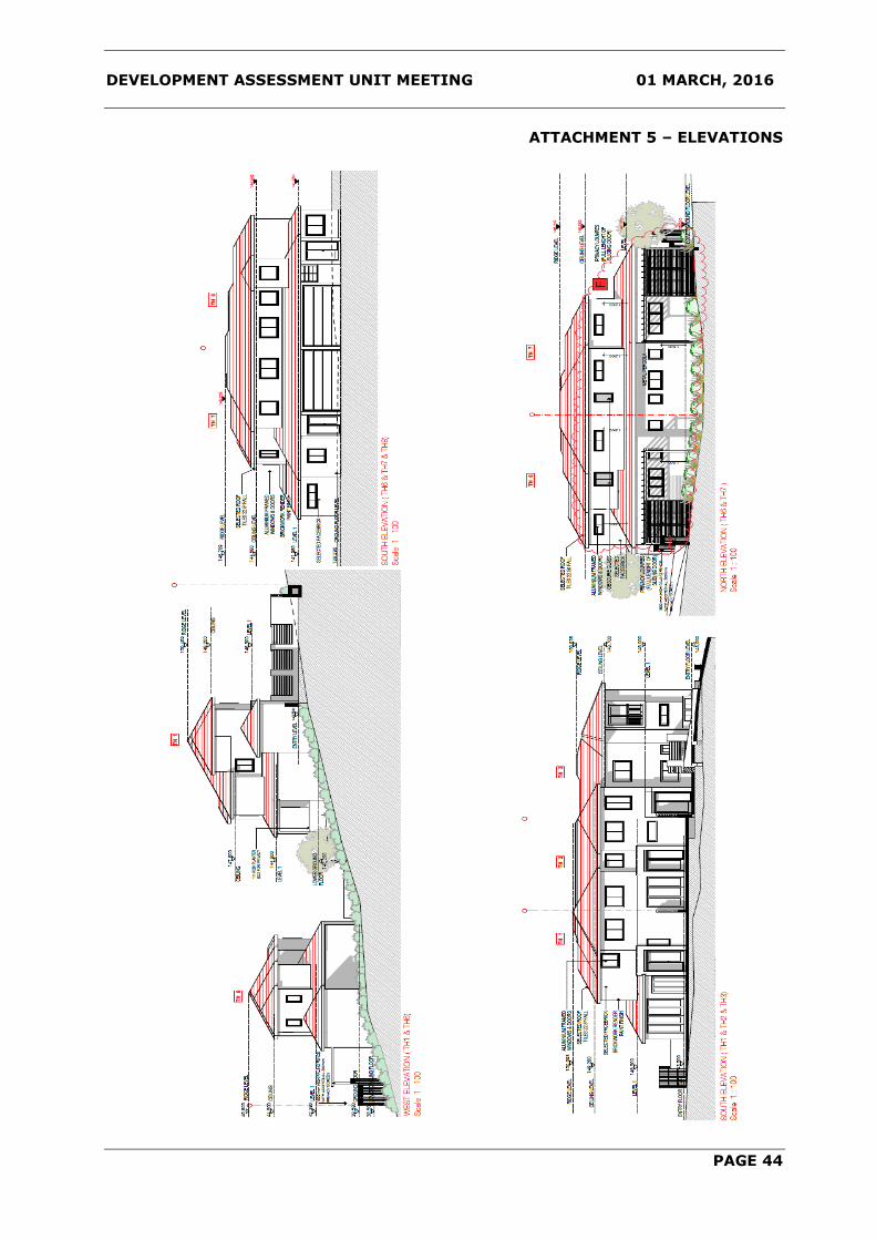
DEVELOPMENT ASSESSMENT UNIT MEETING 01 MARCH, 2016
PAGE 44
ATTACHMENT 5 – ELEVATIONS

DEVELOPMENT ASSESSMENT UNIT MEETING 01 MARCH, 2016
PAGE 45
ATTACHMENT 6 – SECTION PLAN

DEVELOPMENT ASSESSMENT UNIT MEETING 01 MARCH, 2016
PAGE 46
ATTACHMENT 7 – LANDSCAPE PLAN

DEVELOPMENT ASSESSMENT UNIT MEETING 01 MARCH, 2016
PAGE 47
ATTACHMENT 7 – LANDSCAPE PLAN

DEVELOPMENT ASSESSMENT UNIT MEETING 01 MARCH, 2016
PAGE 48
ATTACHMENT 8 – SHADOW DIAGRAMS

DEVELOPMENT ASSESSMENT UNIT MEETING 01 MARCH, 2016
PAGE 49
ITEM-3 DA NO. 396/2016/HA - EXISTING SHED TO BE USED
AS AN INDOOR RECREATION FACILITY (TEENAGERS
RETREAT, OFFICE, STUDIO AND STORAGE) - LOT 9 DP
241639 - NO. 18 JOYLYN ROAD, ANNANGROVE
THEME: Balanced Urban Growth
OUTCOME: 7 Responsible planning facilitates a desirable living
environment and meets growth targets.
STRATEGY:
7.2 Manage new and existing development with a robust
framework of policies, plans and processes that is in
accordance with community needs and expectations.
MEETING DATE: 1 MARCH 2016
DEVELOPMENT ASSESSMENT UNIT
AUTHOR: SENIOR TOWN PLANNER
SANDA WATTS
RESPONSIBLE OFFICER: PRINCIPAL EXECUTIVE PLANNER
KRISTINE MCKENZIE
EXECUTIVE SUMMARY
The proposal is for the use of part of an existing shed as a recreation facility (indoor). The
plans submitted indicate that the ground floor is to be used for storage and a
laundry/bathroom and the upper floor is to contain a studio, office, kitchenette, teenagers
retreat and a bathroom.
The lodgement of the subject application results from compliance action seeking the
cessation of the unauthorised use of the shed and dwelling. A site inspection has
indicated that the shed is currently being used as a dwelling. The proposed use is not
appropriately defined as a recreational facility. It is a dwelling that does not comply with
LEP and waste water requirements. It has not been demonstrated that bushfire and BCA
requirements could be met.
The application was notified to neighbouring properties for 14 days and one submission
was received. The issues raised in the submission relate to unauthorised works,
compliance with the LEP and appropriateness of the proposed use.
The Development Application is recommended for refusal.
BACKGROUND MANDATORY REQUIREMENTS
Applicant: Ken Willis &
Associates
1. LEP 2012 – Unsatisfactory, refer to
report.
Owner: Ms Yvonne Hodgson
2. DCP Part B Section 1 Rural -
Unsatisfactory, refer to report.
Zoning: RU6 Rural Transition. 3. Section 79C (EP&A Act) –
Unsatisfactory, refer to report.
Area: 20,380m²
Existing Development: Dwelling house, shed
and unauthorised
dwelling.

DEVELOPMENT ASSESSMENT UNIT MEETING 01 MARCH, 2016
PAGE 50
SUBMISSIONS REASONS FOR REFERRAL TO DAU
1. Exhibition: No
1. Recommended for refusal.
2. Notice Adj Owners: Yes, 14 days.
3. Number Advised: Five
4. Submissions
Received:
One POLITICAL DONATION – None disclosed.
HISTORY
On 14 January 1993 a shed was approved at the rear of the property with dimensions of
9m x 24m and an area of 216m² (D92/656). The shed has been extended without
approval and is currently used as a dwelling. On 4 December 2014, a building certificate
for an unauthorised carport and masonry wall was approved by Council’s Development
Monitoring Team. The carport which housed helicopters is attached to the southern side
of the existing shed and has since been enclosed (without approval).
On 3 December 2014 a compliant was received advising Council staff that the shed was
being occupied as a dwelling. On 22 December 2014 a letter was sent to the owner
advising that the habitable use of the shed as a dwelling would not be supported in its
current form due to the excessive works that would be required to upgrade the structure
for habitable use. As a result the owner was required to reinstate the existing structure
back to the use as a shed. The cessation of the use of the shed as a dwelling was
required by 19 January 2015. The letter also advised that the building certificate approval
of the carport within the 5 metre setback was a special dispensation given that the
structure was open, without bounding walls and that the Building Code of Australia
requires a carport to have two or more sides open and not less than one third of its
perimeter open.
Between January 2015 and June 2015 a number of letters were exchanged between
Council staff and the owner’s consultant seeking regulation of the unauthorised building
works, use of the shed as a dwelling and shipping container on the site.
On 2 July 2015, Council staff issued the following one Notice of Intention to Give an Order,
which contained the following three Orders:
Order No 1: Seeking the cessation of the use of the shed as a habitable structure.
Order No 2: Seeking the removal of the two shipping containers and the associated
slab and the removal of external Colorbond sheeting installed to the
approved carport.
Order No. 15: Seeking Compliance with Development Consent D92/656, including the
removal of the unauthorised mezzanine and the internal fit out to both
the lower and upper levels of the approved shed.
On 2 September 2015 an Order was issued for Orders 1, 2 and 15. On 24 November
another Notice of Intention to Give an Order was issued to the owner for an 850mm high
masonry wall constructed within 1 metre from the southern side boundary which was
erected without consent.
On the 9 December 2015 a Penalty Infringement Notice was issued for Order 2, and on 11
December 2015 an Order was issued for the unauthorised masonry wall.

DEVELOPMENT ASSESSMENT UNIT MEETING 01 MARCH, 2016
PAGE 51
On 17 February 2016 Order No. 19 was issued requiring the owner to cease carrying out
building works of the unauthorised concrete column, footing and slab at the rear of the
existing shed.
Furthermore, after closer inspection of aerial photographs during the development
assessment process, it was noted that a masonry garage with a concrete roof terrace was
constructed adjacent to the shed (northern side) in 2012 and a car port at the rear of the
shed (south-western side) was constructed in late 2014 without Council approval.
As outlined above, the owner as a history of construction works on the site without prior
consent. Despite Council staff advice that the use of the shed as a dwelling would not be
supported, the owner has lodged the current application.
The following outlines the history only in relation the development application assessment.
03/09/2015 Subject Development Application lodged.
08/01/2016
Letter sent to the applicant stating that the proposal was not
supported given the probability that the structure will be used
for a dwelling given the current internal layout of the building.
It was requested that the Development Application be
withdrawn or the application would be refused.
18/01/2016
Letter received from the applicant stating that “the application
was genuine and applies for a use permissible with consent and
that there was no logical lawful reason why it should not be
approved”. The letter advised that “unless consent is granted
an Appeal will be lodged with the Land and Environment Court
of NSW.”
PROPOSAL
The Development Application is for the use of a portion of an existing shed as a recreation
facility (indoor). The plans submitted indicate that the ground floor is to be used for
storage and a laundry/bathroom and the upper floor to be modified to be used for a
recreation facility (indoor) and is to contain a studio, office, kitchenette, teenagers retreat
and a bathroom. The total floor area of the proposal is 300m² (excluding the existing
portion of the shed being use as a shed).
The structure is currently being used in part as a shed and an unauthorised dwelling which
contains living areas, bathrooms, laundry, bedrooms, office area and a kitchen.
ISSUES FOR CONSIDERATION
1. Compliance with The Hills Local Environmental Plan 2012
a) Permissibility
The subject site is zoned RU6 Rural Transition. The State of Environment Effects (SEE)
states that the proposal is for an indoor recreation facility. An indoor recreation facility is
permissible with consent in the RU6 zone.
LEP 2012 defines recreation facility (indoor) as:
DEVELOPMENT ASSESSMENT UNIT MEETING 01 MARCH, 2016
PAGE 52
A building or place used predominantly for indoor recreation, whether or not operated for
the purposes of gain, including a squash court, indoor swimming pool, gymnasium, table
tennis centre, health studio, bowling alley, ice rink or any other building or place of a like
character used for indoor recreation, but does not include an entertainment facility, a
recreation facility (major) or a registered club.
It is considered that the proposal does not meet the above definition as it is more suited
for larger scale uses from which the public benefits. The proposed use is a private facility
for residents only. The proposal does not contain any of the above uses defined in
recreation facility (indoor) or anything of a ‘like character’. It is considered that the
applicant has attempted to define the use of the shed with a permissible use in the RU6
zone without consideration of the intended definition of the proposed use.
Although a recreation facility (indoor) is permissible in the RU6 Rural Transition zone, it is
considered that the use of the building remains in a form where it is best defined as a
dwelling as the building can be easily converted to a separate domicile. A dwelling is
defined as “a room or suite of rooms occupied or used or so constructed or adapted as to
be capable of being occupied or used as a separate domicile”.
The proposed layout of the building will likely result in its use as a dwelling. The site
inspection undertaken by Council staff indicated that the use of the building is for a
dwelling. The applicant has clearly stated that the building is currently used as a dwelling
with the owner’s son and two grandsons living within (refer to Attachment 7).
Additionally, the portion of the shed that has been unlawfully converted to a dwelling
would not qualify as a potential secondary dwelling (under LEP 2012) given the large size
of the area being used for this purpose. Under LEP 2012 a secondary dwelling is limited to
60m² or 20% of the primary dwelling. The existing approved dwelling on site is
approximately 250m² in area, therefore the proposal would be limited to 60m². The
dwelling component of the shed is 300m².
b) Zone Objectives
The objectives of the RU6 zone are:
To protect and maintain land that provides a transition between rural and other
land uses of varying intensity or environmental sensitivities.
To minimise conflict between land uses within this zone and land uses within
adjoining zones.
To encourage innovation and sustainable tourist development, sustainable
agriculture and the provision of farm produce directly to the public.
The proposal is contrary to the above objectives in that the proposal is for the use of a
building as a dwelling which does not comply with Council’s LEP limit on area. The
proposed use may result in adverse impact to adjoining properties due to use of the
building and the unauthorised works which have been undertaken by the property owner.
2. Compliance with DCP Part B Section 1 - Rural
There are no specific controls for an indoor recreational facility under DCP Part B Section 1
– Rural. The relevant aims and objectives of the DCP are as follows:

DEVELOPMENT ASSESSMENT UNIT MEETING 01 MARCH, 2016
PAGE 53
(ii) To protect, maintain and enhance the natural environment including bushland,
threatened species, river foreshore, wetlands, riparian corridors, ridgelines and
views;
(iii) To ensure that development is compatible with the capability of the land, does not
unreasonably increase demand for services and minimises risks from natural
hazards;
(iv) To encourage the use of the land for agriculture and rural uses, and minimise and
conflict between competing land uses.
(vi) To ensure that development does not have a detrimental impact on the natural
environment, scenic qualities of the area or amenity of surrounding residents, and
that it contributes to the rural character of the area.
Comment:
The site is considered as having a major limiting factor with respect to waste water in that
Cattai Creek adjoins the western boundary, and is located less than 70 metres away from
the existing shed. The DCP requires that waste water systems be located a minimum of
100 metres from permanent surface waters.
It is considered that the proposed development will have adversely impact upon the
natural environment and rural character of the area and results in adverse environmental
impacts.
In view of the above, the proposed development is considered to be inconsistent with the
aims and objectives of the DCP Part B Section 1 – Rural and is not supported.
3. Issues Raised in Submissions
The proposal was notified to surrounding property owners for a period of 14 days and one
submission was received which raised the following concerns:
ISSUE/OBJECTION COMMENT OUTCOME
Native bushland has
been cleared without
permission to make way
for the building.
According to Council records, a Tree
Management Application was lodged
on 22 June 2015 for the removal of
5 trees to the rear (west) of the
shed. This application was approved
on 30 June 2015. There are other
approvals for the removal of any
other trees on the site. A review of
aerial photographs indicates that
unauthorised tree removal has
occurred in the past. The
unauthorised tree removal is being
reviewed by Council’s Development
Monitoring Team in associated with
current action undertaken for the
unauthorised works on the site.
Issue addressed.
The building has grown
from one approved shed,
to another shed without
Council approved which
has been converted to a
dwelling.
As outlined above, the works have
been undertaken with no prior
consent. The Development
Application is recommended for
refusal.
Refusal recommended.

DEVELOPMENT ASSESSMENT UNIT MEETING 01 MARCH, 2016
PAGE 54
Storage is not allowed
under the LEP.
Storage, in association with an
approved use, is permitted with
consent.
Issue addressed.
An office is not allowed
under the LEP.
An office, in association with an
approved use is permitted with
consent. The overall use of the
structure is not supported in this
instance.
Refusal recommended.
The recreation facility
(indoor) as described by
the applicant is not
allowed under the LEP.
Council staff have concern in relation
to the proposed use. The
Development Application is
recommended for refusal.
Refusal recommended.
The septic tank is to be
100 metres from Cattai
Creek.
Council staff have raised concern in
regards to the a future waste water
system and its proximity to Cattai
Creek which is located less than 70
metres from the existing shed.
Refusal recommended.
BUILDING SURVEYOR’S COMMENTS
Council’s Fire Safety Officer has reviewed the Development Application in respect to
compliance with the Building Code of Australia (BCA) and has provided the following
comments:
There is an existing shed structure that is proposed to be used for storage (7b
classification) on the ground floor and a recreation facility (9b classification) on the first
floor.
For Council to be satisfied the level of BCA compliance/fire safety will be sufficient for the
building and its use, the applicant is required to provide a BCA compliance report
addressing Parts B,C,D,E & F of the BCA. The report is to make recommendations as to
the proposed level of BCA compliance the building is to be bought into for the use.
It is noted that advice provided to the owner in 2014 advised that substantial work would
be required to ensure compliance with BCA regulations. A structural report has been
provided with the application, however the applicant has not submitted a BCA compliance
report to support the proposal. In addition it has not been demonstrated that bushfire
requirements can be met.
ENVIRONMENTAL HEALTH & SUSTAINABILITY COMMENTS
Council’s Senior Environmental Health Officer has reviewed the Development Application.
No waste water report was submitted with the application and the site is considered as
having a limiting factor with respect to wastewater in that Cattai Creek adjoins the
western boundary. If the application was considered supportable, Council staff would have
requested that an appropriately qualified wastewater consultant provide a report
demonstrating that the proposed system complies with the Local Government (General)
Regulation 2005, Council’s Development Control Plan Part B Section 1 Rural – Appendix C
– On-site Sewage Management Systems, AS/NZS 1547:2000 – On-site domestic
wastewater management and The Environment and Health Protection Guidelines – On-site
sewage management for single households.
Furthermore, the existing dwelling does not have a current Approval to Operate. Council
staff have sent letters a number of times requiring the owner to submit an application,
however no application has been received. It appears that a waste water system for the
shed is located to the rear of the building, approximately 55 metres from Cattai Creek.
This system does not have an Approval to Operate.

DEVELOPMENT ASSESSMENT UNIT MEETING 01 MARCH, 2016
PAGE 55
CONCLUSION
The proposal has been assessed having regard to the matters for consideration under
Section 79C of the Environmental Planning and Assessment Act, 1979. The proposal fails
to satisfy the objectives of the RU6 Rural Transition zone of the aims and objectives of
DCP Part B Section 1 – Rural. The proposal is considered to be for residential purposes
rather than as an indoor recreation facility. One submission was received and the main
issues raised have been assessed within this report.
Accordingly, the application is recommended for refusal.
IMPACTS
Financial
This matter may have a direct financial impact upon Council’s adopted budget as refusal of
this matter may result in Council having to defend a Class 1 Appeal in the NSW Land and
Environment Court.
The Hills Future Community Strategic Plan
The proposal is considered unsatisfactory and would adversely impact on the amenity of
neighbouring residential properties and will unlikely be used for its proposed use as an
indoor recreation facility.
RECOMMENDATION
The application is recommended for refusal on the following grounds:
1. The proposal not appropriately defined as an recreation facility (indoor) under Local
Environmental Plan 2012 (Section 79C(1)(a)(i) of the NSW Environmental Planning
and Assessment Act, 1979).
2. The proposal is most appropriately defined as a secondary dwelling under Local
Environmental Plan 2012. A dwelling could not be approved in this manner because
Clause 5.4(9) of the Local Environmental Plan 2012 prohibits secondary dwellings with
a floor area exceeding 60m2 or 20% of the total floor area of the principal dwelling
(whichever is greater) Section 79C(1)(a)(i) of the NSW Environmental Planning &
Assessment Act, 1979).
3. The proposed development is inconsistent with the objectives of the RU6 Rural
Transition zone under Local Environmental Plan 2012 (Section 79C(1)(a)(i) of the NSW
Environmental Planning and Assessment Act, 1979).
4. The proposed development is inconsistent with the aims and objectives of DCP Part B
Section 1 – Rural (Section 79C(1)(a)(iii) of the NSW Environmental Planning and
Assessment Act, 1979).
5. The proposed has not been supported by adequate information including a Building
Code of Australia report, Bushfire report or an On-Site Sewerage Management report.

DEVELOPMENT ASSESSMENT UNIT MEETING 01 MARCH, 2016
PAGE 56
ATTACHMENTS
1. Locality Plan
2. Aerial Photograph
3. Site Plan
4. Proposed Floor Plan
5. Proposed Elevations
6. Approved Shed Plan
7. Photographs

DEVELOPMENT ASSESSMENT UNIT MEETING 01 MARCH, 2016
PAGE 57
ATTACHMENT 1 – LOCALITY PLAN

DEVELOPMENT ASSESSMENT UNIT MEETING 01 MARCH, 2016
PAGE 58
ATTACHMENT 2 – AERIAL PHOTOGRAPH

DEVELOPMENT ASSESSMENT UNIT MEETING 01 MARCH, 2016
PAGE 59
ATTACHMENT 3 – SITE PLAN

DEVELOPMENT ASSESSMENT UNIT MEETING 01 MARCH, 2016
PAGE 60
ATTACHMENT 4 – FLOOR PLAN
Proposed Use of Ground Floor
Proposed Use of First Floor

DEVELOPMENT ASSESSMENT UNIT MEETING 01 MARCH, 2016
PAGE 61
ATTACHMENT 5 – ELEVATIONS

DEVELOPMENT ASSESSMENT UNIT MEETING 01 MARCH, 2016
PAGE 62
ATTACHMENT 6 – APPROVED SHED PLAN
Approved Floor Plan
Approved Elevations

DEVELOPMENT ASSESSMENT UNIT MEETING 01 MARCH, 2016
PAGE 63
ATTACHMENT 7 – PHOTOGRAPHS
Current use of room (dining room/lounge) – Proposed use is studio
as part as the indoor recreation facility
Current use of room (kitchen) – Proposed use as kitchenette as
part of the indoor recreation facility

DEVELOPMENT ASSESSMENT UNIT MEETING 01 MARCH, 2016
PAGE 64
Carport that was approved as part of the Building Certificate that
has since been illegally enclosed.
Unauthorised retaining wall that is currently under construction that is
under action by Council’s Development Monitoring Team.

DEVELOPMENT ASSESSMENT UNIT MEETING 01 MARCH, 2016
PAGE 65
Unapproved building works – roof terrace.
Unapproved roof terrace, concrete pillars with garage under.

DEVELOPMENT ASSESSMENT UNIT MEETING 01 MARCH, 2016
PAGE 66
Unapproved carport at rear of dwelling.

DEVELOPMENT ASSESSMENT UNIT MEETING 01 MARCH, 2016
PAGE 67
ITEM-4 DA NO. 465/2016/LD - DEMOLITION OF EXISTING
STRUCTURES AND CONSTRUCTION OF A TWO STOREY
DWELLING, INGROUND SWIMMING POOL AND
RETAINING WALLS - LOT 453 DP 228905 - 7
SANDRINGHAM DRIVE, CARLINGFORD
THEME: Balanced Urban Growth
OUTCOME: 7 Responsible planning facilitates a desirable living
environment and meets growth targets.
STRATEGY:
7.2 Manage new and existing development with a robust
framework of policies, plans and processes that is in
accordance with community needs and expectations.
MEETING DATE: 1 MARCH 2016
DEVELOPMENT ASSESSMENT UNIT
AUTHOR: SENIOR TOWN PLANNER
DAVID KOPPERS
RESPONSIBLE OFFICER: MANAGER DEVELOPMENT ASSESSMENT
PAUL OSBORNE
EXECUTIVE SUMMARY
The Development Application is for the demolition of the existing two storey dwelling and
construction of a new dwelling (part two storey, part single storey), inground swimming
pool and retaining walls.
The proposal has been assessed against the relevant provisions of The Hills Local
Environmental Plan 2012 and The Hills Development Control Plan 2012. There are no
variations to the applicable development controls.
The proposal was notified to adjoining and adjacent property owners and seven (7)
submissions were received in objection to the development. The reasons for objection
included the design of the dwelling being inconsistent with the streetscape and locality,
overshadowing and privacy impacts, and the general impacts associated with demolition
and construction operations.
BACKGROUND MANDATORY REQUIREMENTS
Applicant: J Hekeik 1. LEP 2012 – Permissible – Satisfactory
Owner: J Hekeik
2.
The Hills DCP 2012 - One Variation -
Satisfactory
Zoning: R2 Low Density
Residential
3.
Section 79C (EP&A Act) - Satisfactory
Area:
866.0m2
4.
Section 94 or 94A Contribution – N/A
Existing Development: Residential

DEVELOPMENT ASSESSMENT UNIT MEETING 01 MARCH, 2016
PAGE 68
SUBMISSIONS REASONS FOR REFERRAL TO DAU
1. Exhibition: N/A
1. Variation to DCP.
2. Notice Adj Owners: Yes – 14 days
2. Submissions received.
3. Number Advised: 5
4. Submissions
Received:
7 POLITICAL DONATION – None disclosed.
HISTORY
17/09/2015
21/09/2015
09/10/2015
13/10/2015
02/11/2015
08/12/2015
10/12/2015
Subject Development Application lodged.
Public notification to adjoining and adjacent properties
commenced.
Letter sent to the applicant requesting the amendment of the
Development Application, due to a number of DCP non-
compliances and minor issues with the submitted
documentation which required further clarification.
Email sent to the applicant regarding the nature of submissions
received in objection to the development. Applicant asked to
address concerns raised in the submissions.
Email received from the applicant with amended plans in
response to letter dated 09/10/2015.
Email received from the applicant with amended plans. Minor
revisions and notations required.
Email received from the applicant with final revision of
amended plans.
PROPOSAL
The Development Application is for the demolition of the existing two storey dwelling and
the construction of a new two storey dwelling, sublevel basement garage, inground
swimming pool and retaining walls.
Internal living areas are orientated to the north of the dwelling and private open space is
located within the southern aspect of the site at the rear of the dwelling. Pedestrian access
is provided adjacent to the proposed driveway.
The proposed building materials for the dwelling includes masonry brick with a white
painted render, vertical blade sandstone feature wall and a parapet roof design. Stepped
retaining walls are proposed along the side and front boundaries to enable partial
filling/levelling of the site with a maximum height of 0.83m above natural ground level.

DEVELOPMENT ASSESSMENT UNIT MEETING 01 MARCH, 2016
PAGE 69
ISSUES FOR CONSIDERATION
1. The Hills Local Environmental Plan 2012
Under the provisions of The Hills Local Environmental Plan 2012 (LEP), the subject site is
zoned R2 Low Density Residential. This type of development is categorised as a “dwelling
house” under the LEP which is defined as follows:
dwelling house means a building containing only one dwelling.
Under the provisions of the LEP, dwelling houses are permissible in the R2 Low Density
Residential zone. The objectives of the R2 zone are:
To provide for the housing needs of the community within a low density residential
environment.
To enable other land uses that provide facilities or services to meet the day to day
needs of residents.
To maintain the existing low density residential character of the area.
The development is considered to be consistent with achieving the objectives of the R2
zone.
The maximum building height permitted for the site under the LEP is 9.0m. The maximum
proposed building height is 7.7m to the roof parapet.
2. The Hills Development Control Plan 2012
Part B Section 2 – Residential of The Hills Development Control Plan 2012 (DCP) applies to
the site and proposed development. The proposed development has been assessed against
the relevant controls of the DCP and has been determined as fully compliant against all
relevant development controls, with the exception of the following variations which have
been identified in the table below:
Control
THDCP Requirements Proposed
Development
Compliance
Clause
2.14.1
Front
Setback
The DCP requires a 10.0m
front setback, or alternatively
where the predominant
setback pattern of the street
exceeds the above
requirements, the setbacks of
three (3) adjoining dwellings
either side of the proposed
dwelling will apply.
Variable building line in
Sandringham Drive:
No. 1 = 5.8m
No. 3 = 9.7m
No. 5 = 9.2m
No. 9 = 9.8m
No. 11 = 8.8m
Average = 8.66m
Proposed development
provides a variable
building setback of
8.2m (blade feature
wall) 8.8m, 10.0m &
11.1m.
NO

DEVELOPMENT ASSESSMENT UNIT MEETING 01 MARCH, 2016
PAGE 70
The variations to Clause 2.14.1 of The Hills DCP 2012 Part B Section 2 are addressed
below:
a) Front Setback:
The required front setback for the dwelling is 10 metres. The dwelling is setback 8.2
metres to a blade feature wall 8.8 metres, 10 metres and 11.1 metres. The variation is
supported as it does not generate excessive bulk and scale to the development, it adds an
appropriately designed architectural feature which contributes to the design and character
of the building and it does not negatively impact on adjoining properties or the
streetscape. Other properties in the street also have variations to the 10 metre setback.
The general objectives of the DCP are as follows:
i. Encourage a high standard of aesthetically pleasing and functional residential
developments that sympathetically relate to the adjoining and nearby
developments to create consistent streetscape and character;
ii. Ensure that development will not detrimentally affect the environment of any
adjoining lands and ensure that satisfactory measures are incorporated to
ameliorate any impacts arising from the proposed development;
iii. Encourage innovative and imaginative design with particular emphasis on the
integration of buildings and landscaped areas that add to the character if the
neighbourhood;
iv. Provide high levels of amenity for future residential of any residential development;
v. Implement the principles of Ecologically Sustainable Development.
vi. To facilitate the implementation of the aims and objectives of residential
development as set out in the Hills Shire LEP.
The development is considered to be consistent with achieving the objectives of the DCP in
providing a high standard of innovative design, which provides high levels of amenity for
the residents and does not detrimentally impact on the environment or local community.
3. Issues Raised in Submissions
Seven submissions were received in response to the notification of the development
application. The concerns raised are considered below:
ISSUE/OBJECTION COMMENT OUTCOME
Visually appears to be
a duplex.
The proposed development utilises a
blade wall feature located centrally
within the front building elevation.
Whilst this does visually create a
visual division through the centre of
the dwelling, overall the dwelling
remains visually coherent as a single
dwelling and does not appear as a
duplex. Traditional single dwelling
features which are retained include
the single central pedestrian
entrance and the one double garage.
Issue addressed.

DEVELOPMENT ASSESSMENT UNIT MEETING 01 MARCH, 2016
PAGE 71
ISSUE/OBJECTION COMMENT OUTCOME
The design is not
consistent with
residential streetscape
and locality.
An inspection was carried out within
a catchment radius of 500m from
the development site to ascertain
the overall character of the locality
in relation to housing design. The
surrounding locality is currently
undergoing a period of urban
gentrification with a number of
examples of knock down rebuilds
occurring.
It is apparent that there is no single
defined character within the locality.
The difference in the proposed
development to most dwellings
within the locality is the absence of a
traditional pitched roof on the
proposed dwelling. However, there
are some examples of this in the
wider area. Whilst this may be seen
a design departure it is not
considered a negative aspect to the
development as it significantly
reduces the bulk and scale of the
development, making it significantly
less imposing than many of the
dwellings within the locality.
Issue addressed.
Use of Colorbond
cladding on external
walls is inconsistent
with the locality.
The proposed development utilises
Colorbond cladding in three separate
sections of the external walls which
address the side boundaries. Whilst
there are no examples of other
dwellings within the immediate area
utilising Colorbond products in this
manner, many dwellings within the
locality do utilise various cladding
types to add visual interest to the
design and to break up the
appearance of large wall spaces.
The use of Colorbond cladding is
considered to be consistent with the
overall design of the proposed
development and does not
negatively detract from the overall
design or the character of the
locality.
Issue addressed.

DEVELOPMENT ASSESSMENT UNIT MEETING 01 MARCH, 2016
PAGE 72
ISSUE/OBJECTION COMMENT OUTCOME
General construction
impacts including
dust, noise, covering
of loads and tracking
material onto the road
Concern was also
raised regarding work
hours
Standard conditions of consent are
recommended regarding minimising
noise/dust nuisance and tracking of
material onto the road carriageway.
Covering of loads is not regulated by
Council and is subject to RMS/NSW
Police enforcement.
Standard condition relating to hours
of work.
Issue addressed.
Refer Condition No. 22.
The building setback is
not consistent with
surrounding dwellings
The DCP requires a 10.0m front
setback, or alternatively where the
predominant setback pattern of the
street exceeds the above
requirements, the setbacks of three
(3) adjoining dwellings either side of
the proposed dwelling will apply.
Variable building line in
Sandringham Drive:
No. 1 = 5.8m
No. 3 = 9.7m
No. 5 = 9.2m
No. 9 = 9.8m
No. 11 = 8.8m
Average = 8.66m
Proposed development provides a
variable setback of 8.2m (blade
feature wall) 8.8m, 10.0m & 11.1m.
The dwelling is consistent with the
surrounding dwellings and
incorporates a staggered setback.
The blade wall is a non-compliance
with the DCP and this has been
addressed separately in the report.
The bulk and scale of the
development is significantly less
than the adjoining dwellings.
Issue addressed.
Potential asbestos
exposure during
demolition works.
Standard conditions of consent are
recommended to ensure compliance
with WorkCover standards during
demolition works, including the
consideration of asbestos.
Issue addressed.
Refer Condition No. 17.
DEVELOPMENT ASSESSMENT UNIT MEETING 01 MARCH, 2016
PAGE 73
ISSUE/OBJECTION COMMENT OUTCOME
Concern is raised
regarding the planting
of Tristaniopsis
Laurina (Water Gum)
and the potential
impact of the root
system on adjoining
properties
This concern has been reviewed By
Council’s Landscape Assessment
Officer. A condition of consent is
recommended the following
alternative species to be planted.
Grevillea ‘Moonlight’
Ceratopetalum gummiferum (NSW
Christmas Bush)
Buckinghamia celsissima (Ivory Curl
Tree)
Issue addressed.
Refer Condition No. 11.
Concern is raised
regarding the
potential privacy and
overshadowing
impacts to the
backyard area of No.
5 Sandringham Drive.
Bedroom 3 and 4 address No. 5
Sandringham Drive and elevations
have been subsequently amended to
provide minimum sill heights of
1.5m above finished floor level. This
is consistent with the requirements
of the THDCP 2012 in addressing
potential privacy impacts. Bedrooms
generally have lower occupancy
rates and greater internal privacy
screening when occupied in
comparison to living areas.
The proposed development provides
a moderate overshadowing impact
on the eastern portion of No. 5
during the 9am period and is free of
impact by noon (See attachment 7).
This is considered an acceptable
overall impact and consistent with
residential occupation.
The overall design of the proposed
development provides for a
significantly lower building profile
than either No. 5 or No. 9, and
therefore generates a significantly
lower overshadowing impact than
the adjoining dwellings.
Issue addressed.
CONCLUSION
This application has been assessed in accordance with the ‘Matters for Consideration’ as
noted under Section 79C of the Environmental Planning and Assessment Act 1979. Having
regard to the relevant provisions of The Hills Local Environmental Plan 2012 and The Hills
Development Control Plan 2012, the proposed development is considered to be
satisfactory.
The issues raised in the resident objections have been addressed within this report and do
not further amendment to the development or warrant refusal of the application.

DEVELOPMENT ASSESSMENT UNIT MEETING 01 MARCH, 2016
PAGE 74
The Development Application is recommended for approval subject to conditions.
IMPACTS
Financial
This matter has no direct financial impact upon Council's adopted budget or forward
estimates.
The Hills Future Community Strategic Plan
The proposed development is consistent with the planning principles, vision and objectives
outlined within “Hills 2026 – Looking Towards the Future” as the proposed development
provides for satisfactory growth without adverse environmental or social amenity impacts.
The social and environmental impacts have been identified and addressed in the
report. The proposal provides a satisfactory design that does not compromise the
character of the locality and the Shire as a whole.
The proposal represents balanced urban growth, and the proposed residential
development will complement the nature of the site. The proposal fits within the context of
the site and is considered to be consistent with the long-term direction and goals for the
locality.
RECOMMENDATION
The Development Application be approved subject to the following conditions of consent.
GENERAL MATTERS
1. Development in Accordance with Submitted Plans
The development being carried out in accordance with the following approved plans and
details, stamped and returned with this consent except where amended by other
conditions of consent.
REFERENCED PLANS AND DOCUMENTS
DWG NO. DESCRIPTION SHEET REV DATE
Survey Plan 1 of 1 18/06/2014
Site / Ground Floor Plan DA 01 C December 2015
Site / Lower Ground Floor DA 02 C December 2015
Elevations DA 03 C December 2015
Section A-A / Pool Details DA 04 C December 2015
Shadow Diagram / Site Analysis DA 05 C December 2015
Calculations / Details DA 06 C December 2015
15150 DA 1 Landscape Concept Plan A 03/09/2015
D1
Stormwater Management Plan:
Details, Notes & Legend
A 03/09/2015

DEVELOPMENT ASSESSMENT UNIT MEETING 01 MARCH, 2016
PAGE 75
D2 Stormwater Management Plan:
Site / Ground Floor Plan & Details
A 03/09/2015
D3 Stormwater Management Plan:
Lower Ground Floor Plan
A 03/09/2015
D4 Stormwater Management Plan:
Roof Drainage Plan
A 03/09/2015
D5 Stormwater Management Plan:
Stormwater Details
A 03/09/2015
D6 Sediment Control Plan A 03/09/2015
D7 Sediment Control Details A 03/09/2015
No work (including excavation, land fill or earth reshaping) shall be undertaken prior to
the issue of the Construction Certificate, where a Construction Certificate is required.
2. Construction Certificate
Prior to construction of the approved development, it is necessary to obtain a Construction
Certificate. A Construction Certificate may be issued by Council or an Accredited Certifier.
Plans submitted with the Construction Certificate are to be amended to incorporate the
conditions of the Development Consent.
3. Building Work to be in Accordance with BCA
All building work must be carried out in accordance with the provisions of the Building
Code of Australia.
4. Adherence to Waste Management Plan
All requirements of the Waste Management Plan submitted to and approved by Council
must be implemented during the construction and/ or demolition phases of the
development, as well as the ongoing management phase. The information submitted can
change provided that the same or a greater level of reuse and recycling is achieved as
detailed in the plan.
Any material moved offsite is to be transported in accordance with the requirements of the
Protection of the Environment Operations Act 1997 and only to a place that can lawfully be
used as a waste facility. Receipts of all waste/ recycling tipping must be kept onsite at all
times and produced in a legible form to any authorised officer of the Council who asks to
see them.
5. Management of Construction and/ or Demolition Waste
Waste materials must be appropriately stored and secured within a designated waste area
onsite at all times, prior to its reuse onsite or being sent offsite. This includes waste
materials such as paper and containers which must not litter the site or leave the site onto
neighbouring public or private property. A separate dedicated bin must be provided onsite
by the builder for the disposal of waste materials such as paper, containers and food
scraps generated by all workers.
Building waste containers are not permitted to be placed on public property at any time
unless a separate application is approved by Council to locate a building waste container in
a public place. Any material moved offsite is to be transported in accordance with the
requirements of the Protection of the Environment Operations Act 1997 and only to a
place that can lawfully be used as a waste facility.

DEVELOPMENT ASSESSMENT UNIT MEETING 01 MARCH, 2016
PAGE 76
The separation and recycling of the following waste materials is required: metals, timber,
masonry products and clean waste plasterboard. This can be achieved by source
separation onsite, that is, a bin for metal waste, a bin for timber, a bin for bricks and so
on. Alternatively, mixed waste may be stored in one or more bins and sent to a waste
contractor or transfer/ sorting station that will sort the waste on their premises for
recycling. Receipts of all waste/ recycling tipping must be kept onsite at all times and
produced in a legible form to any authorised officer of the Council who asks to see them.
6. Demolition Inspections
Before demolition works commence, a pre-demolition inspection must be arranged with
Council’s Development Certification team. All conditions required to be addressed before
works commence must be satisfied. Once demolition works are complete, a post
demolition inspection must be arranged with Council’s Development Certification team.
7. Demolition Notification
Both Council and any adjoining properties must be notified in writing five days before
demolition works commence.
8. Surplus Excavated Material
The disposal of surplus excavated material, other than to a licenced waste facility, is not
permitted without the formal approval of Council prior to works commencing onsite. Any
unauthorized disposal of waste, which includes excavated material, is a breach of the
Protection of the Environment Operations Act 1997 and subject to substantial penalties.
Receipts of all waste/ recycling tipping must be kept onsite at all times and produced in a
legible form to any authorised officer of the Council who asks to see them.
9. Commencement of Domestic Waste Service
The property owner or agent acting for the owner must ensure to arrange the
commencement of a domestic waste service with Council. The service is to be arranged no
earlier than two days prior to occupancy and no later than two days after occupancy of the
development. All requirements of Council’s domestic collection service must be complied
with at all times. Please telephone Council on (02) 9843 0310 for the commencement of
waste services.
10. Provision of Domestic Waste Storage Area
Sufficient space must be allocated onsite to store a minimum of three 240 litre mobile bins
(for waste streams as determined by Council). Note two separate areas are required for
dual occupancies. The location is required to ensure that the bins are not visible from any
adjoining property or public place, are easily accessible by future occupants and allow the
bins to be wheeled to the street over flat or ramped surfaces, grade not to exceed 1:14,
and not over steps, kerbs, landscape edging or through a habitable area of the dwelling.
11. Planting Requirements
The proposed plantings of Tristaniopsis Laurina are to be replaced with the following
species:
Grevillea ‘Moonlight’
Ceratopetalum gummiferum (NSW Christmas Bush)
Buckinghamia celsissima (Ivory Curl Tree)
12. External Finishes
External finishes and colours shall be in accordance with the details submitted with the
development application and approved with this consent.
PRIOR TO WORK COMMENCING ON THE SITE
13. Principal Certifying Authority
A sign is to be erected in accordance with Clause 98 A (2) of the Environmental Planning
and Assessment Regulations 2000.

DEVELOPMENT ASSESSMENT UNIT MEETING 01 MARCH, 2016
PAGE 77
14. Builder and PCA Details Required
Notification in writing of the builder’s name, address, telephone and fax numbers to be
submitted to the Principal Certifying Authority prior to work commencing.
Two days before work commences, Council shall be notified of the Principal Certifying
Authority in accordance with the Regulations.
15. Management of Building Sites – Builder’s Details
The erection of suitable fencing or other measures to restrict public access to the site and
building works, materials or equipment when the building work is not in progress or the
site is otherwise unoccupied.
The erection of a sign, in a prominent position, stating that unauthorised entry to the site
is not permitted and giving an after-hours contact name and telephone number. In the
case of a privately certified development, the name and contact number of the Principal
Certifying Authority.
16. Consultation with Service Authorities
Applicants are advised to consult with Telstra, NBN Co and Australia Post regarding the
installation of telephone conduits, broadband connections and letterboxes as required.
Unimpeded access must be available to the electricity supply authority, during and after
building, to the electricity meters and metering equipment.
The building plans must be submitted to the appropriate Sydney Water office to determine
whether the development will affect Sydney Water’s sewer and water mains, stormwater
drains and/or easements. If the development complies with Sydney Water’s
requirements, the building plans will be stamped indicating that no further requirements
are necessary.
17. Demolition Works and Asbestos Management
The demolition of any structure is to be carried out in accordance with the Work Health
and Safety Act 2011. All vehicles transporting demolition materials offsite are to have
covered loads and are not to track any soil or waste materials on the road. Should
demolition works obstruct or inconvenience pedestrian or vehicular traffic on adjoining
public road or reserve, a separate application is to be made to Council to enclose the
public place with a hoard or fence.
All demolition works involving the removal and disposal of asbestos (of an area more than
10 square metres) must only be undertaken by a licenced asbestos removalist who is
licenced to carry out the work. Asbestos removal must be carried out in accordance with
the WorkCover, Environment Protection Authority and Office of Environment and Heritage
requirements. Asbestos to be disposed of must only be transported to waste facilities
licenced to accept asbestos. No asbestos products are to be reused on the site.
18. Approved Temporary Closet
An approved temporary closet connected to the sewers of Sydney Water, or alternatively
an approved chemical closet is to be provided on the land, prior to building operations
being commenced.
19. Erosion and Sedimentation Controls
Erosion and sedimentation controls shall be in place prior to the commencement of site
works; and maintained throughout construction activities until the site is landscaped
and/or suitably revegetated. The controls shall be in accordance with the details approved
by Council and/or as directed by Council Officers. These requirements shall be in
accordance with Managing Urban Stormwater – Soils and Construction produced by the
NSW Department of Housing (Blue Book).

DEVELOPMENT ASSESSMENT UNIT MEETING 01 MARCH, 2016
PAGE 78
20. Stabilised Access Point
A stabilised all weather access point is to be provided prior to commencement of site
works, and maintained throughout construction activities until the site is stabilised. The
controls shall be in accordance with the requirements with the details approved by Council
and/or as directed by Council Officers. These requirements shall be in accordance with
Managing Urban Stormwater – Soils and Construction produced by the NSW Department
of Housing (Blue Book).
21. Sydney Water Building Plan Approval
A building plan approval must be obtained from Sydney Water Tap in™ to ensure that the
approved development will not impact Sydney Water infrastructure. A copy of the building
plan approval receipt from Sydney Water Tap in™ must be submitted to the Principal
Certifying Authority upon request prior to works commencing.
Please refer to the web site http://www.sydneywater.com.au/tapin/index.htm , Sydney
Water Tap in™, or telephone 13 20 92.
DURING CONSTRUCTION
22. Hours of Work
Work on the project to be limited to the following hours:
a) Monday to Saturday - 7.00am to 5.00pm;
b) No work to be carried out on Sunday or Public Holidays.
The builder/contractor shall be responsible to instruct and control sub-contractors
regarding the hours of work.
23. Dust Control
The emission of dust must be controlled to minimise nuisance to the occupants of the
surrounding premises. In the absence of any alternative measures, the following
measures must be taken to control the emission of dust:
a) Dust screens must be erected around the perimeter of the site and be kept in good
repair for the duration of the construction work;
b) All dusty surfaces must be wet down and suppressed by means of a fine water
spray. Water used for dust suppression must not cause water pollution; and
c) All stockpiles of materials that are likely to generate dust must be kept damp or
covered.
24. Survey Report
Survey Certificate to be submitted to the Principal Certifying Authority at footings and/or
formwork stage. The certificate shall indicate the location of the building in relation to all
boundaries, and shall confirm the floor level prior to any work proceeding on the building.
25. Compliance with BASIX Certificate
Under clause 97A of the Environmental Planning and Assessment Regulation 2000, it is a
condition of this Development Consent that all commitments listed in BASIX Certificate No.
661863S be complied with. Any subsequent version of this BASIX Certificate will
supersede all previous versions of the certificate.
A Section 96 Application may be required should the subsequent version of this BASIX
Certificate necessitate design changes to the development. However, a Section 96
Application will be required for a BASIX Certificate with a new number.

DEVELOPMENT ASSESSMENT UNIT MEETING 01 MARCH, 2016
PAGE 79
26. Compliance with Critical Stage Inspections and Other Inspections Nominated
by the Principal Certifying Authority
Section 109E(3)(d) of the Act requires certain specific inspections (prescribed by Clause
162A of the Regulations) and known as “Critical Stage Inspections” to be carried out for
building work. Prior to permitting commencement of the work, your Principal Certifying
Authority is required to give notice of these inspections pursuant to Clause 103A of the
Regulations.
N.B. An Occupation Certificate cannot be issued and the building may not be able to be
used or occupied where any mandatory critical stage inspections or other inspections
required by the Principal Certifying Authority are not carried out.
Where Council is nominated as Principal Certifying Authority, notification of all inspections
required is provided with the Construction Certificate approval.
NOTE: You are advised that inspections may only be carried out by the PCA
unless by prior agreement of the PCA and subject to that person being an
accredited certifier.
27. Roof Water Drainage
Gutter and downpipe and/or rainwater tank overflow, to be provided and connected to an
approved lawful discharge point (ie. kerb, inter-allotment drainage easement or OSD)
upon installation of roof coverings.
28. Filtration Motor Noise
The sound pressure level of the swimming pool filter and pump equipment shall not
exceed (at the boundary) a level greater than 5dB (A) above the background noise level in
accordance with Protection of the Environmental Operations Act 1997. If the noise of the
filter causes a nuisance to the occupiers of adjacent dwellings, the swimming pool filter
and pump shall be fully enclosed in an enclosure to attenuate noise emitted by the
swimming pool equipment.
29. Pool Discharge Water
Discharge and/or overflow pipe from the swimming pool and filtration unit to be connected
to the sewer where available.
All backwash water from the filtration unit is to be similarly disposed, or alternatively,
must be piped to an absorption trench.
The pool excavations not to conflict with the position of household drainage trenches or
lines, the position of which must be ascertained before pool excavation commences.
30. Pool not to be Filled Until Occupation
The pool is not to be filled with water until the dwelling is occupied.
31. Swimming Pool Safety Fencing
All pools and safety barriers are to comply with the Swimming Pools Act 1992, the
Swimming Pools Regulation 2008 and Australian Standard 1926.1-2012. A fact sheet
titled Swimming Pool Fencing Requirements is available from www.thehills.nsw.gov.au.
It should be noted that any steps, retaining walls, objects (for example – planter boxes,
pump enclosures and the like) or level changes that would otherwise reduce the height of
the barrier within a property shall not be located within 500mm of the barrier.
32. Resuscitation Warning Notice
In accordance with the Swimming Pools Regulation 2008, a Warning Notice is to be
displayed in a prominent position, in the immediate vicinity of the swimming pool. The
notice is to contain a diagrammatic flow chart of resuscitation techniques, the words:

DEVELOPMENT ASSESSMENT UNIT MEETING 01 MARCH, 2016
PAGE 80
"YOUNG CHILDREN SHOULD BE SUPERVISED WHEN USING THIS SWIMMING POOL",
a) and
b) "POOL GATES MUST BE KEPT CLOSED AT ALL TIMES", and
c) "KEEP ARTICLES, OBJECTS AND STRUCTURES AT LEAST 900 MILLIMETRES CLEAR
OF THE POOL FENCE AT ALL TIMES",
And all other details required by the Regulation.
PRIOR TO ISSUE OF AN OCCUPATION CERTIFICATE
33. Registration of Swimming Pool/Spa
Prior to issue of an Occupation Certificate the swimming pool/spa is to be registered on
the NSW state register of swimming pools and spas. To register the swimming pool/spa
you are to log onto www.swimmingpoolregister.nsw.gov.au and follow the prompts. A
copy of the registration certificate is to be submitted to the PCA to confirm the
registration.
ATTACHMENTS
1. Locality Plan
2. Aerial Photograph
3. Existing Site Plan
4. Proposed Site Plan
5. Elevations
6. Section & Pool Details
7. Shadow Diagrams
8. Landscape Plan
9. Locality Photos – Dwelling Examples

DEVELOPMENT ASSESSMENT UNIT MEETING 01 MARCH, 2016
PAGE 81
ATTACHMENT 1 – LOCALITY PLAN

DEVELOPMENT ASSESSMENT UNIT MEETING 01 MARCH, 2016
PAGE 82
ATTACHMENT 2 – AERIAL PHOTOGRAPH

DEVELOPMENT ASSESSMENT UNIT MEETING 01 MARCH, 2016
PAGE 83
ATTACHMENT 3 – EXISTING SITE PLAN

DEVELOPMENT ASSESSMENT UNIT MEETING 01 MARCH, 2016
PAGE 84
ATTACHMENT 4 – PROPOSED SITE PLAN

DEVELOPMENT ASSESSMENT UNIT MEETING 01 MARCH, 2016
PAGE 85
ATTACHMENT 5 – ELEVATIONS

DEVELOPMENT ASSESSMENT UNIT MEETING 01 MARCH, 2016
PAGE 86
ATTACHMENT 6 – SECTION & POOL DETAILS

DEVELOPMENT ASSESSMENT UNIT MEETING 01 MARCH, 2016
PAGE 87
ATTACHMENT 7 – SHADOW DIAGRAMS

DEVELOPMENT ASSESSMENT UNIT MEETING 01 MARCH, 2016
PAGE 88
ATTACHMENT 8 – LANDSCAPE PLAN

DEVELOPMENT ASSESSMENT UNIT MEETING 01 MARCH, 2016
PAGE 89
ATTACHMENT 9 – LOCALITY PHOTOS – DWELLING EXAMPLES
11 Westminster Avenue
4B Westminster Avenue

DEVELOPMENT ASSESSMENT UNIT MEETING 01 MARCH, 2016
PAGE 90
11 Snowdon Avenue
19 Snowdon Avenue

DEVELOPMENT ASSESSMENT UNIT MEETING 01 MARCH, 2016
PAGE 91
21 Snowdon Avenue
5 Sandringham Drive

DEVELOPMENT ASSESSMENT UNIT MEETING 01 MARCH, 2016
PAGE 92
26 Arcadian Circuit
7 Arcadian Circuit
DEVELOPMENT ASSESSMENT UNIT MEETING 01 MARCH, 2016
PAGE 93
17 Arcadian Circuit
89 Felton Road