Dan-Y-Graig Brickworks, Risca Proposed Residential Development · 2017-10-16 · Dan-Y-Graig...
43
Dan-Y-Graig Brickworks, Risca Proposed Residential Development Geo-Environmental Assessment
Transcript of Dan-Y-Graig Brickworks, Risca Proposed Residential Development · 2017-10-16 · Dan-Y-Graig...
Dan-Y-Graig Brickworks, RiscaProposed Residential Development
Geo-Environmental Assessment

This page is left intentionally blank
Dan-Y-Graig Brickworks RiscaProposed Residential Development
Geo-Environmental Assessment
Prepared for:P D Edenhall LtdDanygraig Works
RiscaNewport
NP11 6DP.
N.B. Once issued this document is Uncontrolled, for the latest version and/or to confirm you have authorisation to use it please contact theEarth Science Partnership at [email protected] or by telephone at 029 2081 3385.
This document has been optimised for double sided printing and therefore may produce some blank pages when printed single sided.
+ 33 Cardiff Road, Taff's Well, CARDIFF, CF15 7RB ( 029 2081 3385* [email protected] www.earthsciencepartnership.com
Document Reference: ESP.5481b.2925
Revision Status Date Written by Checked by Approved by
00 Draft July 2017B Cross
BSc (Hons) FGSD Bettosi
BSc (Hons) MSc CGeolFGS
G. SommerwillBSc (Hons) MSc CGeol FGS
RoGEP Specialist SiLC
Signature:
Notes: 1. The status of this report is not final and is issued for comment only; as such, it is subject to changetherefore it should not be relied up on. For a checked and authorised version please contact theEarth Science Partnership.
2. This report is issued in advance of the return of all the laboratory test data results such that thefactual data gathered during the fieldwork stage and the index texting results can be utilised asearlier as practicable.
Report General Notes
1) Earth Science Partnership (ESP) believes that providing information about limitations is essential to help clientsidentify and therefore manage their risks. These risks can be mitigated through further investigation or research, butthey cannot be eliminated.
2) This report may not be used for any purpose other than that for which it was commissioned.
3) We have taken reasonable efforts to ensure the accuracy and reliability of the information presented herein. Someof this information has been obtained from third party sources and they are referenced as appropriate. Nevertheless,no guarantee is provide on the authenticity or reliability of this information.
4) This report has been prepared for the sole benefit, use and information of the organisation named within the reportand in accordance with terms of the commission. It has been prepared for the purposes detailed in the report only.
5) The report has been prepared for the use and reliance of the organisation named within the report and in accordancewith terms of the commission. The report shall not be relied upon or transferred to other parties without the expresswritten authorisation of the Earth Science Partnership. Hence no duty of skill or care is transferred to any third party.
6) The copyright in this report and other plans and documents prepared by the ESP is owned by them and no such report,plan or document may be reproduced, published or adapted without their consent. However, complete copies of thisreport may be made and distributed by the Client as an expedient in dealing with matters related to its commission
Proposed Residential DevelopmentGeo-Environmental Assessment
Dan-Y-Graig Brickworks, Risca i DraftESP.5481b.2925 - 00 July 2017
Contents
1 Introduction 11.1 Background ................................................................................................................... 1
1.2 Objective and Scope of Works ...................................................................................... 2
1.3 Report Format ............................................................................................................... 2
1.4 Limitations of Report ..................................................................................................... 2
1.5 Digital Copy of Report.................................................................................................... 3
2 DESK STUDY AND FIELD RECONNAISSANCE VISIT 42.1 Site Location and Description ....................................................................................... 4
2.2 Site History .................................................................................................................... 6
2.3 Previous Investigations and Assessments .................................................................... 8
2.4 Contact with Regulatory Bodies & Local Information Sources ...................................... 8
2.5 Hydrology ....................................................................................................................... 8
2.6 Geology........................................................................................................................ 10
2.7 Hydrogeology ............................................................................................................... 12
2.8 Environmental Setting ................................................................................................. 13
2.9 Preliminary Geotechnical Risk Register ...................................................................... 14
2.10 Past Coal Mining ......................................................................................................... 15
2.11 Past Non-Coal Mining .................................................................................................. 16
2.12 Shrinkable and Swelling Soils ..................................................................................... 16
2.13 Landslips ..................................................................................................................... 17
2.14 Compressible Ground.................................................................................................. 17
2.15 Running Sand .............................................................................................................. 17
2.16 Radon Hazard ............................................................................................................. 17
2.17 Pyritic Ground .............................................................................................................. 18
2.18 Buried Unexploded Ordnance (UXO) ........................................................................... 18
3 PRELIMINARY GEO-ENVIRONMENTAL RISK ASSESSMENT 193.1 Phase One Conceptual Site Model .............................................................................. 19
3.2 Preliminary Risk Evaluation & Plausible Pollutant Linkages ....................................... 22
4 RECOMMENDED FURTHER WORK 25
Proposed Residential DevelopmentGeo-Environmental Assessment
Dan-Y-Graig Brickworks, Risca ii DraftESP.5481b.2925 - 00 July 2017
Appendix A Risk Evaluation Methodology
Appendix B Historical Maps
Appendix C Enviro-Insight Environmental Data Report
Appendix D Exploratory Hole Records from Previous Investigations (ESP 2005)
Appendix E Coal Authority Mining Report
Appendix F Correspondence with Caerphilly County Council
Appendix G Borehole Records Available from the British Geological Survey (BGS, 2017)
Appendix H Preliminary UXO Risk Assessment (Zetica, 2016)
Figures and Tables
Figure 1: Site Location Plan 1:25,000 (Ordinance Survey License No.: AL100015788). ............... 1Figure 2 Site Location Plan. Scale 1:2500. Based on Google Earth Imaging (2017). ..................... 4Figure 3: Extract from NRW Flood Risk Map (NRW, 2017) Scale 1:5,000 ....................................... 9Figure 4 Extract from BGS Solid Geology Sheet 249, 1:50,000 (BGS licence number: C15/05CSL)................................................................................................................................................. 10
Table 1: Review of Historical Maps ................................................................................................... 6Table 2: Summary of Environmental Data - .................................................................................... 13Table 3: Preliminary Geotechnical and Geo-environmental Risk Register ..................................... 15Table 4: Preliminary Risk Evaluation & Plausible Pollutant Linkages (PPL) ................................... 24
Proposed Residential DevelopmentGeo-Environmental Assessment
Dan-Y-Graig Brickworks, Risca 1 DraftESP.5481b.2925 - 00 July 2017
1 Introduction
1.1 Background
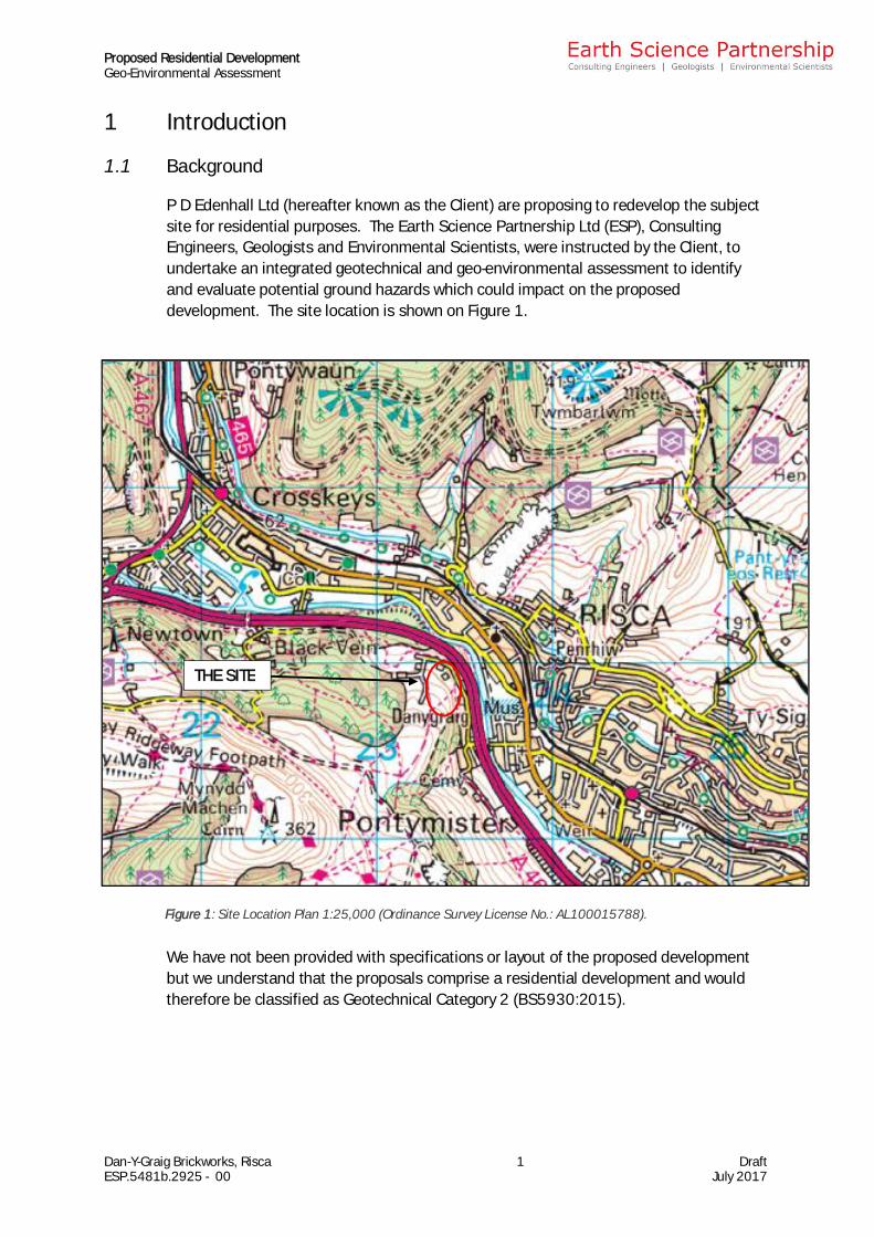
P D Edenhall Ltd (hereafter known as the Client) are proposing to redevelop the subjectsite for residential purposes. The Earth Science Partnership Ltd (ESP), ConsultingEngineers, Geologists and Environmental Scientists, were instructed by the Client, toundertake an integrated geotechnical and geo-environmental assessment to identifyand evaluate potential ground hazards which could impact on the proposeddevelopment. The site location is shown on Figure 1.
We have not been provided with specifications or layout of the proposed developmentbut we understand that the proposals comprise a residential development and wouldtherefore be classified as Geotechnical Category 2 (BS5930:2015).
Figure 1: Site Location Plan 1:25,000 (Ordinance Survey License No.: AL100015788).
THE SITE
Proposed Residential DevelopmentGeo-Environmental Assessment
Dan-Y-Graig Brickworks, Risca 2 DraftESP.5481b.2925 - 00 July 2017
1.2 Objective and Scope of Works
The objective of the investigation was to obtain information on the geotechnicalcharacter and properties of the ground beneath the site, potential risks posed bycontamination and ground gas, and to allow an assessment of these ground conditionswith particular reference to the potential impact on the proposed development.
The Client has not yet obtained planning permission for the proposed development.
The scope of works for the investigation was mutually developed with the Client by ESPwithin an agreed budget, and comprised a desk study review of available historicalOrdnance Survey maps, environmental data, geological maps, memoirs and data, andfurther desk study information, a field reconnaissance visit and reporting.
The contract was awarded on the basis of a competitive tender quotation. The terms ofreference for the assessment are as laid down in the Earth Science Partnership proposalof 16th May 2017 (ref: db/5481b/lt1 Rev 1). The investigation and assessment wasundertaken in June 2017.
1.3 Report Format
This report includes the desk study and field reconnaissance (Section 2), along with thePreliminary Risk Assessment stage of CLR11 (Section 3) and the report concludes with asummary of any further surveys/ investigations/ assessments recommended(Section 4).
The assessment of the potential for hazardous substances (contamination) or conditionsto exist on, at or near the site at levels or in a situation likely to warrant mitigation orconsideration appropriate to the proposed end use has been undertaken using theguidance published by CIRIA (2001). This is discussed in more detail in Section 3.2.1.
1.4 Limitations of Report
This report represents the findings of the brief relating to the proposed end use andgeotechnical category of structure(s) as detailed in Section 1.1. The brief did not requirean assessment of the implications for any other end use or structures, nor is the report acomprehensive site characterisation and should not be construed as such. It should beappreciated that no intrusive investigation has been undertaken to date. Should analternative end use or structure be considered, the findings of the assessment shouldbe re-examined relating to the new proposals.
Where preventative, ameliorative or remediation works are required, professionaljudgement will be used to make recommendations that satisfy the site specificrequirements in accordance with good practice guidance.
Consultation with regulatory authorities will be required with respect to proposed worksas there may be overriding regional or policy requirements which demand additionalwork to be undertaken. It should be noted that both regulations and their interpretationby statutory authorities are continually changing.
Proposed Residential DevelopmentGeo-Environmental Assessment
Dan-Y-Graig Brickworks, Risca 3 DraftESP.5481b.2925 - 00 July 2017
This report represents the findings and opinions of experienced geo-environmental andgeotechnical specialists. Earth Science Partnership does not provide legal advice andthe advice of lawyers may also be required.
1.5 Digital Copy of Report
This report is issued as a digital version only.
Proposed Residential DevelopmentGeo-Environmental Assessment
Dan-Y-Graig Brickworks, Risca 4 DraftESP.5481b.2925 - 00 July 2017
2 DESK STUDY AND FIELD RECONNAISSANCE VISIT
The information presented in this section was obtained from desk-based research ofsources detailed in the text, including historical maps (Appendix B), an environmentaldata report (Appendix C), information on a previous investigation at the site (AppendixD), Coal Authority report (Appendix E), correspondence with the Local Authority (AppendixF), borehole records obtained from the British Geological Society (Appendix G) and apreliminary unexploded ordnance (UXO) risk assessment (Appendix H). Further recordsare included as subsequent appendices as referenced in the text.
2.1 Site Location and Description
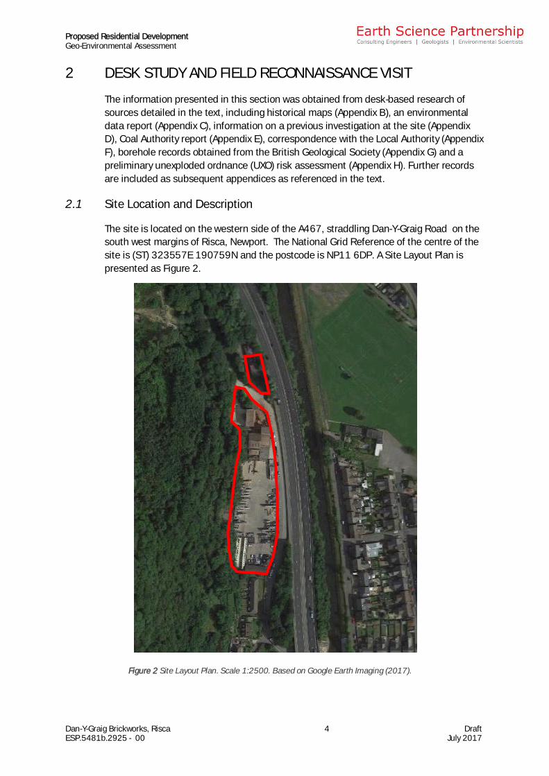
The site is located on the western side of the A467, straddling Dan-Y-Graig Road on thesouth west margins of Risca, Newport. The National Grid Reference of the centre of thesite is (ST) 323557E 190759N and the postcode is NP11 6DP. A Site Layout Plan ispresented as Figure 2.
Figure 2 Site Layout Plan. Scale 1:2500. Based on Google Earth Imaging (2017).
Proposed Residential DevelopmentGeo-Environmental Assessment
Dan-Y-Graig Brickworks, Risca 5 DraftESP.5481b.2925 - 00 July 2017
The site comprises two parcels of land and in entirety are around 200m length (north tosouth) and 50m width (east to west), occupying an area of around 1ha.
The site is split by Dan-Y-Graig Road with the north portion occupied by an electricitysubstation, a hardstanding storage yard and a single storey brick building. The southportion is currently occupied by the existing Dan Y Graig brickworks, with associatedareas of hardstanding and stock storage.
It is bounded by:
To the north: immediately by the A467 Road followed by an area of woodland stretchingnorth approximately 50m to the north
To the east: immediately by Dan-Y-Graig Road with the A467 10m to the east, followedby the Ebbw River 30m to the east, followed by residential areas of Risca
To the south: houses of Dan-Y-Graig Road followed by Tir-Y-Cwm Lane approximately70m to the south
To the west: immediately by woodland sloping upwards towards the west
Vehicular access to the site is currently gained via gates leading off Dan-Y-Graig on theeastern boundary. The boundaries generally comprise brick free-standing walls.
The general topography in the area slopes towards the Ebbw River to the east, and thesite itself is relatively flat, however, steep slopes are recorded at the west and eastboundaries.
A topographic survey has been provided by the Client and indicates that the majority ofthe site is relatively level, standing at an elevation of around 58m AOD. There is a steeprise to the west of the site, with an area of dense vegetation sloping up to approximately70m AOD. Dan-Y-Graig road to the east stands at a similar level to the site climbing as itpasses through the north of the site to approximately 62m AOD.
A walkover of the site undertaken on the 27th July 2017, identifies a similar site layoutas that available from the aerial imagery and historical mapping. The north portion of thesite is occupied by a small building and yard, with a number of pallets of brick storedoutside. Some flytipped materials are also present in this area. Electrical substationsthat were tentatively identified on mapping have been confirmed in this north portion.
The main south portion of the site is occupied by the existing and operationalbrickworks, a storage yard, and office buildings in the far south portion. An approximate1m fall in levels in identified between the storage yard and office areas. The storageyard is primarily noted to be used to store manufactured bricks with a series of fourlarge above ground tanks and associated bund also present in the south central portion.A steep slope is present at the west boundary, rising sharply westward. Dan Y GraigRoad is present at the east boundary, followed by a significant drop to the A467 dualcarriageway.
Proposed Residential DevelopmentGeo-Environmental Assessment
Dan-Y-Graig Brickworks, Risca 6 DraftESP.5481b.2925 - 00 July 2017
2.2 Site History
2.2.1 Published Historical Maps
The site history has been assessed from a review of available historical Ordnance SurveyCounty Series and National Grid maps. Extracts from the historical maps are presentedin Appendix B and the salient features since the First Edition of the County Series mapsare summarised in Table 1 below.
Table 1: Review of Historical MapsDate On-Site In Vicinity of Site1882 Buildings present in southern portion of
site, labelled as Chemical Works.Terraced houses present in northernportion stretching north towards Dan-Y-Graig including the Sugarloaf PublicHouse. Limekiln indicated directlyadjacent to site at north west corner.
Villages of Risca and Pont-y-Mister lie 500m tothe north east and south west, respectively.Strong industrial presence indicated with ‘Daren’and ‘Cwm Byr’ collieries 800m to the north west,brick works 500m to the north west, gas and tinworks 1km to the south east and BritanniaFoundry and blacking factory 1km to the southeast. Railway tracks indicated either side of theEbbw River travelling east. A number of woodedpockets of land lie to the north and west. TheEbbw River lies 30m to the east, trend northsouth and wells are located 50m to the southeast, 400m to the south west and 750m to thesouth west.
1898 -1901
7no. large kilns indicated and buildingsoccupying the site renamed as Dan-Y-Graig Brickworks. Evidence of cutting intothe western portion of the site. Tramtracks indicated serving brickworksbuildings, joining the main tramway 125mto the north before it branches over theriver.
Quarries indicated directly adjacent to westboundary and 500m to the north. Old quarriesindicated 60m to south west and 300m to thesouth. Tramway branches 125m to the north,crossing the Ebbw River. Rifle range indicated800m to south west extending to within 200m ofthe site. Trial shafts indicated 800m to the westand old coal and clay levels indicated 650m tothe north west. Old Colliery Rows indicated600m to the north west.
1915 -1917
No significant changes indicated. Rifle range no longer indicated to the south west.Tramway/railway to north and east nowindicated as Great Western Railway Nine MilePoint Branch. Further residential developmentand widening of streets in Risca to the northeast. ‘Long Bridge’ Tramroad across the EbbwRiver no longer indicated 30m to the east(dismantled in 1905).
1920 -1938
No significant changes indicated. No significant changes indicated.
1948 No significant changes indicated. Electricity transmission line indicated 350m towest trending north south.
1962 –1964
Tramway no longer indicated on site.Conveyor and weighbridge indicated tothe north of site. Larger buildings andkilns no longer indicated in southernportion of site, replaced by hardstandingand smaller building on south boundary.Houses no longer indicated to occupy landat north east tip of site.
Further cutting indicated to north east of sitetowards embankment of Ebbw River. Quarry tothe west of site named as ‘Danygraig Quarry’,involved in the excavation of stone. Furtherexcavations indicated into cliff face of Dan-Y-Graig.

Proposed Residential DevelopmentGeo-Environmental Assessment
Dan-Y-Graig Brickworks, Risca 7 DraftESP.5481b.2925 - 00 July 2017
1695 Further buildings indicated to north ofsite behind conveyor.
No significant changes indicated.
1970 No significant changes indicated. Quarries to north and north west indicated asdisused. Extensive limestone quarrying
indicated 500m to the north, named as ‘RiscaQuarry’.
1982 Travelling crane and silos indicated onsite.
Electricity substation indicated adjacent toeastern boundary. Weir indicated spanning
Ebbw River 20m to the east. Dan-Y-Graig Quarryto west indicated as disused.
1986 Electricity substation indicated in northeast corner of site.
A467 dual carriageway bypass road indicatebordering east boundary – potential infilling andstraightening of Ebbw River to complete works.
Weir no longer indicated. Subway entranceindicated 40m to north passing under A467
from south west to north east. Electricitysubstations indicated 50m to south east
opposite Dan-Y-Graig bungalows.1993 No significant changes indicated. Refuse tip indicated 140m to the west.
2002 –2014
No significant changes indicated. No significant changes indicated.
2.2.2 Other Sources
The following (unreferenced) information has been gathered from other external andonline sources.
On site
The Union Copper Company opened the Dan-y-Graig copper works in 1807 on the site ofRoman lead mines, before being taken over as a chemical works run by David Morris in1816. A further change of use occurred in 1895 which saw it become Edwin SouthwoodJones' brickworks. Historic photos can be seen in the enclosed Plates. Themanufacturing output of these works continued into the 20th and 21st century, movingon to more modern construction supplies such as pre-cast concrete products.
Industrial history
By the end of the 18th Century, the industrial revolution in the coalfield of South Walesand Monmouthshire had progressed so far as to require improved means of transport tothe shipping ports on the coast. In 1792 the Monmouthshire Canal Company wasincorporated and authorised to build canals and railways; these followed the course oftwo valleys, the Eastern Valley to Pontypool and Blaenavon and the Western Valley toRisca and Beaufort.
The expansion of these lines over a number of years enabled the transport of goodsfrom the number of foundries, ironworks, forges and mines that littered the valleys toreach wider markets in Newport and beyond (Skillern, 1960).
2.2.3 Archaeological Setting
A full archaeological assessment was not included within the brief, but we have not beenadvised of, or identified, any obvious evidence of any significant archaeological featureson the site. We recommend that consideration is given to employing a specialistarchaeological consultant to review the historical and archaeological setting.
Proposed Residential DevelopmentGeo-Environmental Assessment
Dan-Y-Graig Brickworks, Risca 8 DraftESP.5481b.2925 - 00 July 2017
2.2.4 Ecology
We understand that ecological assessments have been undertaken at the site as part ofthe proposed development. We understand that these have been undertaken by a thirdparty and these have not been provided to ESP at this time.
2.3 Previous Investigations and Assessments
Earth Science Partnership (ESP) undertook an integrated geotechnical and geo-environmental assessment approximately 300m to the south west of the site in June2006 (Ref: 3642c/1133) for the proposed redevelopment of the Risca Palace cinema.for commercial purposes. The investigation comprised 6no. trial pits to a depth of 2.4m– 3.1m. Geotechnical and geo-environmental laboratory testing was undertaken and anassessment of geotechnical and contamination risks was completed.
For ease of reference, copies of the relevant investigation point records are provided inAppendix D and the salient information is discussed further in the following relevantsections.
2.4 Contact with Regulatory Bodies & Local Information Sources
The Local Authority (Caerphilly County Council) have been contacted as part of thisassessment. At the time of issue of this report, we have not yet received a responsefrom the consultees. Once received, any response will be forwarded under separatecover. It should be appreciated that their responses may contain salient information onthe site which could not be taken into account during the preparation of this report.
2.5 Hydrology
2.5.1 Surface Water Features
The nearest major surface water feature to the site is the Ebbw River (classified as aPrimary River) which flows from north to south approximately 32m to the east. Anumber of streams and smaller rivers are also present in the area, the closest of whichlies some 65m to the south, and is classified as a Tertiary River (see Appendix C).
The environmental data report (Appendix C) indicates that the latest data shows thewater quality (in terms of biology) in the Ebbw River between the confluence with theSirhowy River (1km to the north west) and the site was classified as Grade B (good)between 2005 and 2009. In terms of chemistry, the water quality over the same stretchof river was classed as Grade A (very good) between 2005 and 2007, declining toGrade C (fair) in 2008.
2.5.2 Surface Water Abstractions
The environmental data report (Appendix C) indicates that there are no surface waterabstractions within 250m of the site.
Proposed Residential DevelopmentGeo-Environmental Assessment
Dan-Y-Graig Brickworks, Risca 9 DraftESP.5481b.2925 - 00 July 2017
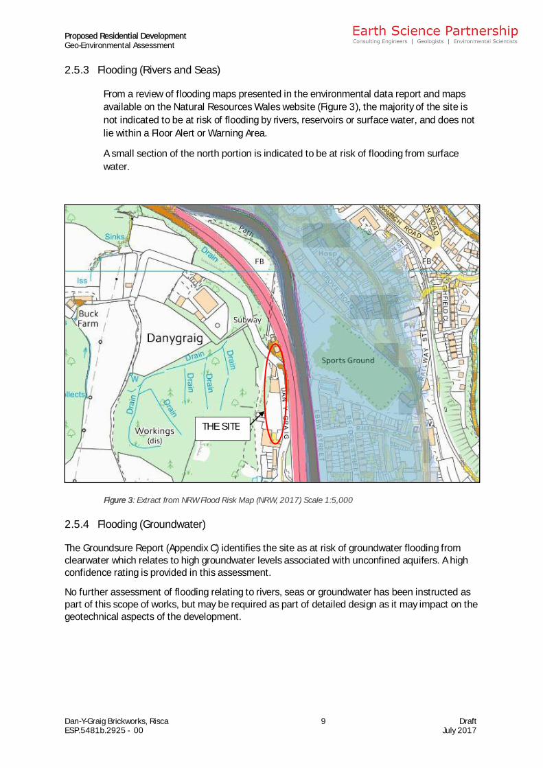
2.5.3 Flooding (Rivers and Seas)
From a review of flooding maps presented in the environmental data report and mapsavailable on the Natural Resources Wales website (Figure 3), the majority of the site isnot indicated to be at risk of flooding by rivers, reservoirs or surface water, and does notlie within a Floor Alert or Warning Area.
A small section of the north portion is indicated to be at risk of flooding from surfacewater.
2.5.4 Flooding (Groundwater)
The Groundsure Report (Appendix C) identifies the site as at risk of groundwater flooding fromclearwater which relates to high groundwater levels associated with unconfined aquifers. A highconfidence rating is provided in this assessment.
No further assessment of flooding relating to rivers, seas or groundwater has been instructed aspart of this scope of works, but may be required as part of detailed design as it may impact on thegeotechnical aspects of the development.
Figure 3: Extract from NRW Flood Risk Map (NRW, 2017) Scale 1:5,000
THE SITE
Proposed Residential DevelopmentGeo-Environmental Assessment
Dan-Y-Graig Brickworks, Risca 10 DraftESP.5481b.2925 - 00 July 2017
2.6 Geology
2.6.1 Published Geology
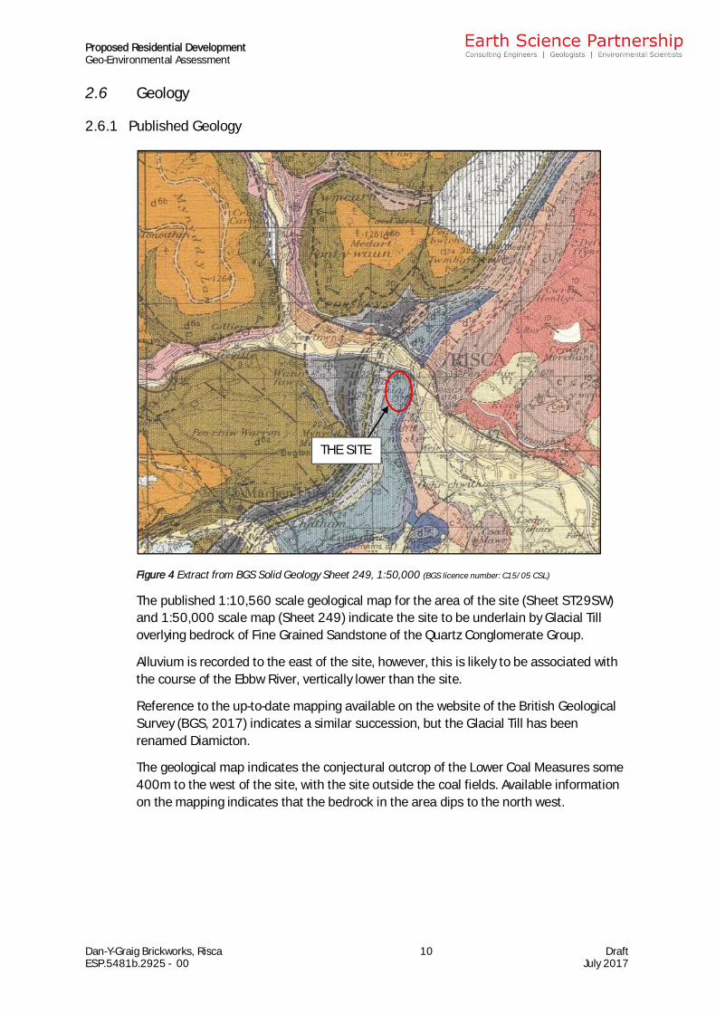
Figure 4 Extract from BGS Solid Geology Sheet 249, 1:50,000 (BGS licence number: C15/05 CSL)
The published 1:10,560 scale geological map for the area of the site (Sheet ST29SW)and 1:50,000 scale map (Sheet 249) indicate the site to be underlain by Glacial Tilloverlying bedrock of Fine Grained Sandstone of the Quartz Conglomerate Group.
Alluvium is recorded to the east of the site, however, this is likely to be associated withthe course of the Ebbw River, vertically lower than the site.
Reference to the up-to-date mapping available on the website of the British GeologicalSurvey (BGS, 2017) indicates a similar succession, but the Glacial Till has beenrenamed Diamicton.
The geological map indicates the conjectural outcrop of the Lower Coal Measures some400m to the west of the site, with the site outside the coal fields. Available informationon the mapping indicates that the bedrock in the area dips to the north west.
THE SITE
Proposed Residential DevelopmentGeo-Environmental Assessment
Dan-Y-Graig Brickworks, Risca 11 DraftESP.5481b.2925 - 00 July 2017
2.6.2 Available BGS Borehole Records/Previous Investigation
Reference to the website of the British Geological Survey (BGS, 2016) indicates theavailable records of 12no. boreholes within 100m of the site. Copies of the availableborehole records along with a plan showing their positions relative to the site arepresented in Appendix G.
The borehole records indicate the following:
· ST29SW-46: drilled in 1972 on the east boundary indicated Fill (colliery discard)to 1m, followed by Gravel, Cobbles and Boulders with bands of Sand to 6.45m.
· ST29SW-47: drilled in 1972 on the east boundary indicated Fill to 4.5m (topsoilto 0.3m, followed by bricks, ashes and soft clay to 4.5m).
· ST29SW-86: drilled in 1976 on the north east boundary indicated loose Fill(ashy, clayey sand, gravel, glass and brick fragments) to 7m, followed byLimestone fragments to 8.65m
· ST29SW-87: drilled in 1976 15m to the east of the site indicated Fill (silty sand,gravel, cinders, rags, domestic refuse, glass and pottery) to 7.6m, followed bySand with Gravel and Cobbles to 9.1m.
· ST29SW-129 drilled in 1976 15m to the north east indicated Gravel, Cobblesand Boulders to 3.5m.
· ST29SW-130 drilled in 1976 20m to the north east indicated Gravel to 4m,followed by Limestone Cobble and Gravel to 5m, followed by Shale withLimestone ribs to 6.4m, followed by Mudstone with Limestone and Shale bandsto 10.30m
· ST29SW-131 drilled in 1976 20m to the east indicated Gravel and Cobbles to4.9m.
· ST29SW-132 drilled in 1976 25m to the east indicated Gravel and Cobbles (withoccasional Sandstone and Limestone boulders) to 4.8m, followed by asuccession of Limestone and Siltstone to 9.4m.
· ST29SW-133 drilled in 1976 25m to the east indicated Fill (black silty sand withgravel and cobbles) to 1m, followed by Gravel and Cobbles to 3.5m, followed bySand with Gravel and cobbles to 7.4m, followed by Sandstone and LimestoneConglomerate Cobbles and Boulders to 8.65m, followed by Mudstone to 9.15m,followed by Limestone Conglomerate to 10.7m, followed by Siltstone to 11.8.
· ST29SW-134 drilled in 1976 25m to the east indicated Fill (silty sand with roots)to 1m, followed by Gravel to 10m, followed by Sand to 11.5m, followed by Sandand Gravel to 13.15m.
Proposed Residential DevelopmentGeo-Environmental Assessment
Dan-Y-Graig Brickworks, Risca 12 DraftESP.5481b.2925 - 00 July 2017
· ST29SW-135 drilled in 1976 indicated Fill (silty sand to gravel with roots andcoal) to 2.6m, Gravel and Cobbles to 3m, Sand and Gravel (possible fill) to 5m,followed by Gravel to 6m, followed by Sand and Gravel to 11m, followed by Sandand Cobbles to 13.5m, followed by Clay (with fragments of mudstone andweathered sandstone) to 14.8, followed by Mudstone to 16.1m, followed bySandstone to 17.5m.
· ST29SW-154 drilled in 1976 indicates Fill (cinders, broken bottles, rags, lawnmowings, sacks, concrete posts, paving slabs) to 5.7m
2.7 Hydrogeology
2.7.1 Aquifer Classification
Reference to the aquifer maps published on the environmental data report indicatesthat the superficial deposits beneath the site (Glacial Deposits) are classed asUnproductive Strata, whilst the bedrock (QCG Sandstone) is classed as a PrincipalAquifer.
Principal Aquifers generally correspond with the previously classified major aquifers andare described by the Environment Agency as ‘rock or drift deposits that have highintergranular and/or fracture permeability’. They may support water supply and/or riverbase flow on a strategic scale. Principal Aquifers are particularly sensitive to pollution.
Unproductive Strata are bedrock or drift deposits of low permeability, which havenegligible significance for water supply or river base flow. Unproductive Strata are theleast sensitive in terms of pollution.
2.7.2 Anticipated Groundwater Bodies
The Groundsure Report (Appendix C) identifies the potential for high groundwater levelsassociated with unconfined aquifers (shallow groundwater within bedrock).
It is likely that shallow and localised perched water bodies will be present within anyoverlying Made Ground and Glacial Deposits at the site.
The previous boreholes drilled in close proximity to the site identified groundwater at 3mdepth rising to 2.7m within the Glacial Deposits.
It is likely that any groundwater contained within the glacial deposits will have a limited ifany hydraulic connection with the Ebbw River.
2.7.3 Abstractions and Groundwater Vulnerability
The environmental data report indicates that the nearest groundwater abstraction pointlies some 1000m to the south east of the site. This abstraction is reportedly used forevaporative cooling for the Pontymister Steelworks. The abstraction permit is notassociated with a Source Protection Zone.
Proposed Residential DevelopmentGeo-Environmental Assessment
Dan-Y-Graig Brickworks, Risca 13 DraftESP.5481b.2925 - 00 July 2017
2.7.4 Groundwater Movement
Groundwater movement within the superficial Glacial Deposits will be controlled byintergranular flow whilst, in the bedrock, fracture flow is likely to be dominant.
2.8 Environmental Setting
2.8.1 Summary of Environmental Data
The site exists in a historically rural, and now a predominantly urban setting. Anenvironmental data report has been obtained for the site and is presented in AppendixC, and the data therein is summarised in
Table 2 below.
Table 2: Summary of Environmental Data -Item On the Site In the Immediate Vicinity
8 Environmentally Sensitive Sites 2 None identified. Dan-y-Graig quarry located 223m to thewest. 19no. records of ancient woodland
within 500m.1 Potentially Contaminative Land
Use21no. records on site includingrailway sidings, tanks, lime kilnsand use of the land as chemical
and brick works.
30no. records within 250m including tramsidings 90m to the west, quarries
approximately 15m to the west, 90m to thewest and 143m to the north west, groundworkings 201m to the north and 223m to
the south west and a cemetery 244m to thesouth.
1 Historical Tanks, PFS, Garages,Energy Facilities
4no. tanks and2no. electricity substations.
5no. records within 250m relating to 2no.tanks 104m to east and 203m to south.
6no. entries within 250m relating to 4no.electricity substations 8m to east, 45m tosouth, 130m to south east, 250m to east.
1no. garage 246m to east.1 Potentially Infilled Land 5no. entries relating to brick
works located on site.Potentially infilled quarry identified 15m tothe west, pond 70m to the south, pool 78mto the east, old quarries 100m to the west
and 140m to the north west, unspecified pit185m to the south west, ground workings201m to the north and cemetery 244m to
the south.2 IPPC Authorisations None identified. None recorded within 500m of the site.
2 Discharge Consents None identified. 7no. consents relating to 2no. currentpermits for of sewer storm overflow
discharges into Rhynys Brook 375m and398m to the south east.
2 List 1 and 2 DangerousSubstances Sites
None identified. None recorded within 500m of the site.
2 Radioactive Substance Sites None identified. None recorded within 500m of the site.
2 Enforcements None identified. None recorded within 500m of the site.
Proposed Residential DevelopmentGeo-Environmental Assessment
Dan-Y-Graig Brickworks, Risca 14 DraftESP.5481b.2925 - 00 July 2017
2 Pollution Incidents None identified. 2no. incidents:- 110m to south east (Apr 2013)
Pollutant: sewage materials LandImpact: 3 Air Impact: 4.
- 373m to east (Aug 2013)Pollutant: construction and demolitionmaterials and waste Land Impact: 4 AirImpact: 3
2 Contaminated Land under Part 2AEPA 1990.
None identified. None recorded within 500m of the site.
3 Waste Management Facilities None identified. 20no. records for waste managementfacilities (including historic records) within1km with the closest of Dan-y-Graig Quarry15m to the west. See Section 2.8.2.
4 Current Industrial/CommercialSites
3no. records relating toelectricity substation, conveyorand Edenhall Ltd (bricks, tiles,
clay and ceramic products).
4no. entries relating to refuse tip 15m to thewest, electricity substation 38m to the south
east, tank 103m to the east and signagecompany 225m to the north east.
Notes1. Numbers on left refer to relevant Sections in environmental data report (Appendix C).2. Sensitive land uses include Sites of Special Scientific Interest, Nature Reserves, National Parks, Special Areas of
Conservation, Special Protection Areas, Ramsar sites, World Heritage sites and Ancient Woodland.3. Nitrate vulnerable areas relate to the agricultural use of fertilizers and are not considered further in this
assessment.
2.8.2 On-Site Bulk Liquid Storage
We understand that there are 3no. above ground oil tanks on the east boundary of thesite, comprising rectangular steel tanks, constructed within a concrete floored, brickwalled bunded area. A further steel tank has been identified to the south of the conveyorbuilding and is cylindrical in construction, again located within a concrete floored, brickwalled bunded area.
2.8.3 On-Site Bulk Materials and Waste Storage
A number of storage areas have been identified on site including stockpiles ofconstruction materials on the external hardstanding yard and a covered aggregate storeto the west of the conveyor. Pallets of bricks and other construction materials have alsobeen observed in the building occupying the northernmost portion of the site.
2.9 Preliminary Geotechnical Risk Register
2.9.1 Summary of Potential Geotechnical and Geomorphological Hazards
The potential for various geotechnical and geomorphological hazards at the site isprovided in the environmental data report (Appendix C). The potential hazards, asreported in this report, are listed in Table 3 below, along with any salient furtherinformation on the potential hazards identified by ESP in the preparation of this report.Where a potential hazard has been identified, it is discussed further in subsequentsections.
Proposed Residential DevelopmentGeo-Environmental Assessment
Dan-Y-Graig Brickworks, Risca 15 DraftESP.5481b.2925 - 00 July 2017
Table 3: Preliminary Geotechnical and Geo-environmental Risk Register
Ground Stability Hazard Potential1 ESP Comment
Coal Mining Low See Section 2.10
Mining (non-coal) - See Section 2.11
Shrinking or Swelling Clays Very Low See Section 2.12
Landslips Moderate See Section 2.13
Ground Dissolution (SolubleRocks) Low No further information identified to contradict data
report.
Compressible Ground Moderate See Section 2.14
Collapsible Ground Very Low No further information identified to contradict datareport.
Running Sand Low See Section 2.15
Radon - See Section 2.16
Sulphate/Pyritic Ground Not reported. See Section 2.17
Unexploded Ordnance Not reported. See Section 2.18
Notes1. Potential as reported in environmental data report (Appendix C)2. Salient hazards discussed in following sections.
2.10 Past Coal Mining
Whilst not within the South Wales coal fields, the site lies in close proximity to areas thatwere mined for coal. Reference to the available geological maps does not suggest thatany seams crop out locally to the site. Reference to the Coal Authority website (CA,2017) provides the following salient information:
· No past surface hazard or surface mining is identified in the vicinity of the site.
· No recorded or probable past shallow coal mining is indicated in the vicinity ofthe site.
· No mine entries are shown within the site boundary.
· The site does not lie within a ‘Development High Risk Area’.
As the site is on the borders of the south Wales coal field and in order to provide acomprehensive assessment, a mining report has also been obtained from the CoalAuthority and is presented in Appendix E. This indicates that based on the available CoalAuthority records:
· The property is not within a surface area that could be affected by pastunderground mining.
Proposed Residential DevelopmentGeo-Environmental Assessment
Dan-Y-Graig Brickworks, Risca 16 DraftESP.5481b.2925 - 00 July 2017
· The property is not within a surface area that could be affected by presentunderground mining.
· The property is not within the likely zone of influence of any present undergroundcoal workings.
· The property is not in an area which is earmarked/being considered for futureunderground working. However, reserves of coal exist which could be worked atsome time in the future.
· There are no known coal mine entries within, or within 20m of, the boundary ofthe site.
· No notice of the risk of the land being affected by subsidence has been givenunder Section 46 of the Coal Mining Subsidence Act 1991. There are norecorded claims within 50m of the site boundary.
Based on the available evidence and the site location, the risk posed by coal mining isconsidered to be Low.
2.11 Past Non-Coal Mining
The environmental data report and review of the history of the site suggests that miningof mineral veins/non coal commodities could have occurred on the site and in thevicinity, with additional unreferenced historical information identifying the site as aformer Roman Lead mine.
The extraction of mineral as identified on available historical information indicatesabove ground / open cast mining such as quarries etc. We have identified noinformation to suggest that mining may be a sub-surface hazard beneath the site.
However, in areas such as this, the risk cannot be totally discounted and we recommendthat a careful watch is maintained during development and any anomalous groundfeatures identified which could be indicative of mine entries are subjected to furtherinvestigation.
Based on the available information, we consider the potential for non-coal mining at thesite is Moderate.
2.12 Shrinkable and Swelling Soils
The environmental data reports the risk of shrinkable and swelling soils is Very Lowindicating ground conditions of predominantly low plasticity.
However, there is the possibility of the presence of fine grained Glacial Deposits beneaththe site which are susceptible to shrinkage and swelling. Also, depending on the designof the proposed development, if any existing trees are removed from the site this maychange the moisture content of the shallow soils resulting in potential volume change.
We consider that the potential for shrinkable and swelling soils at the site should beadvanced from that reported in the environmental data report (Table 3, Very Low) toModerate.
Proposed Residential DevelopmentGeo-Environmental Assessment
Dan-Y-Graig Brickworks, Risca 17 DraftESP.5481b.2925 - 00 July 2017
2.13 Landslips
Reference to available landslip mapping does not indicate any land slips in the vicinity ofthe site. As the site does slope, and cutting has occurred at the west boundary there is apotential for localised instability.
The hillsides in this area of south Wales are known for small to large scale movements,exacerbated by high precipitation. In addition to this the proposed development willinvolve cutting into the existing slopes at the site and could lead to instability in the longterm. Therefore, we consider that the potential for landslips at the site as reported inthe environmental data report (Table 3, Moderate) is appropriate.
2.14 Compressible Ground
The glacial deposits anticipated beneath the site comprise soils of probable low strengthand may contain organic materials and, hence, are potentially compressible. The MadeGround soils anticipated beneath the site are potentially compressible, particularly wherecontaining organic materials are present, which could lead to significant settlement at thesurface.
The environmental data report indicates the risk from compressible ground for the site tobe Moderate and we concur with this assessment.
2.15 Running Sand
The glacial soils anticipated at shallow depth beneath the site commonly contain a highproportion of sand and can contain significant water bodies. Therefore, given theanticipated shallow groundwater level (see Section 2.7), if intercepted within theexcavations, we consider that the potential for running sands beneath the site should beadvanced from that reported in the environmental data report (Table 3, Low) toModerate.
2.16 Radon Hazard
Radon is a colourless, odourless, radioactive gas, which can pose a risk to humanhealth. It originates in the bedrock beneath the site, where uranium and radium richminerals are naturally present, and can move through fractures in the bedrock, andoverlying superficial deposits, to collect in spaces within/beneath structures.
The environmental data report (Appendix C) indicates that the site lies in a radonaffected area as defined by the Health Protection Agency, with between 10 and 30% ofproperties above the action level.
Reference to the UK radon maps published by Public Health England (accessed onlinePHE, 2017) also indicates that the site lies in an area classified as a maximum radonpotential of between 10 and 30%.
These maps indicate the worst level of radon potential, based on existing informationgathered mainly from residential properties within the 1km square in which the site islocated. It is designed as a preliminary evaluation only.
Proposed Residential DevelopmentGeo-Environmental Assessment
Dan-Y-Graig Brickworks, Risca 18 DraftESP.5481b.2925 - 00 July 2017
Reference to BRE 211 (Scivyer, 2007) indicates that the site lies in a 1km square wherethe maximum requirements are for full radon protection measures in new buildings(domestic or non-domestic).
Given the currently available information, the risk from radon is considered to be High,with full radon protection measures required.
2.17 Pyritic Ground
The environmental data report does not consider the potential risk from sulphate rich orpyritic ground. Depending on its origin, the Made Ground and Glacial Depositsanticipated beneath the site may also contain elevated levels of pyrite. Given the above,we consider that the potential for sulphate/pyrite attack on buried concrete would beModerate.
2.18 Buried Unexploded Ordnance (UXO)
The environmental data report does not consider the potential risk from unexplodedordnance at the site.
Reference to UXO risk maps available on-line (Zetica, 2017) suggests that the site islocated within a Moderate risk region with regards to the risk from buried unexplodedordnance.
A Preliminary UXO Desk Study assessment of risk has been completed by a specialistOrdnance consultant in accordance with CIRIA guidelines (Stone et al, 2009) and ispresented in Appendix H (Zetica, 2016). This indicates that during World War II, the sitewas located in the Urban District of Risca which officially recorded 27no. high explosivebombs with a low regional bombing density of 6.4 bombs per 405 ha.
Although the site lies in a historically industrial area, no readily available records havebeen found indicating that the site was bombed.
Given the above, we consider that the potential for unexploded ordnance beneath thesite would be Low.
Proposed Residential DevelopmentGeo-Environmental Assessment
Dan-Y-Graig Brickworks, Risca 19 DraftESP.5481b.2925 - 00 July 2017
3 PRELIMINARY GEO-ENVIRONMENTAL RISK ASSESSMENT
3.1 Phase One Conceptual Site Model
3.1.1 Background
The Phase One Conceptual Site Model lists the potential sources of geo-environmentalrisk, the receptors at risk and the pathways between the two. These are discussed inthe following sections.
3.1.2 Potential Sources of Soil/Water Contamination
Potential Contamination Sources:
The site history has indicated that it has been it has been developed as a chemicalworks and brickworks including previous railway access, which are potentiallycontaminative uses. From the available information, we consider that the followingfeatures on site could prove sources of diffuse and point source contamination thatcould impact on the development, environment or site users:
· Made Ground – general diffuse contamination;
· Use of site as a quarry, chemical works and brick works - point and diffusesource from any spillages or storage;
· Possible historical use of the site as a Roman Lead mine;
· Electricity sub-station – point source;
· Current above/underground fuel tanks – point source;
· Construction rubble – possible presence of asbestos containing materials (ACM),point source;
· Former railway/tramway across site – point source;
· Road construction – diffuse source due to unknown nature of any backfillmaterials used to realign Ebbw River and built up surface levels for the A467;
· Former limekiln on north west boundary and larger kilns along east boundary –point source;
Potential Contaminants Present:
The potential contaminants associated with the above potential sources have beenidentified from various guidelines published by DEFRA, the Environment Agency andothers. The particular guidance referenced includes the Industry Profile for RailwayLand (DoE, 1995). Based on this guidance and our experience, we consider that thefollowing contaminants could be present on the site:
· heavy metals and semi-metals (arsenic, barium, cadmium, chromium, copper,lead, mercury, nickel, selenium, vanadium, zinc); plus other metals as indicated(e.g. barium, boron);
Proposed Residential DevelopmentGeo-Environmental Assessment
Dan-Y-Graig Brickworks, Risca 20 DraftESP.5481b.2925 - 00 July 2017
· sulphate, sulphide;
· polyaromatic hydrocarbon (PAH) compounds;
· petroleum hydrocarbons;
· polychlorinated biphenyls (PCBs) – from around the substation;
· Volatile and semi-volatile organic compounds (VOCs & SVOCs);
· asbestos.
No evidence has been identified from the desk study to suggest that radioactivesubstances may be present on the site. The potential presence of radon in discussed inSection 3.1.4.
3.1.3 Potential Sources of Hazardous Ground Gas
Based on the available information, the following potential sources of hazardous groundgas have been identified on, or in close vicinity of, the site:
· General Made Ground – organic and other materials could generate combustibleand noxious gases;
· The Dan-y-Graig Quarry Landfill, located 15m to the west - combustible andnoxious gases will almost certainly have been generated in the putresciblewaste;
· Petroleum hydrocarbons within Made Ground – unweathered hydrocarbons cangenerate hazardous volatile organic vapours and as they degrade, thehydrocarbons can generate combustible and noxious gases;
Based on the guidelines presented by O’Riordan and Milloy (1995) and revised byWilson et al (2009), the above potential gas sources would generally be classified as oflow gas generation potential, however, the nearby landfill would be classified as ofmoderate to high gas generation potential
3.1.4 Potential Sources of Radon
As discussed in Section 2.16, the site is located within an area where the maximumradon potential is 10% to 30%. Based on the available information, the radon is likely tooriginate in the Sandstone bedrock beneath the site.
3.1.5 Potential Receptors
As discussed in Section 1.1, we understand the proposed site development willcomprise residential properties with private gardens, landscaping and vehicle parkingareas.
The site is located only 30m from the Ebbw River (separated by the A467) and above aPrincipal Aquifer.
Given the above, we consider that the most vulnerable receptors with regards to anycontamination or hazardous ground gas present are likely to be as follows.
Proposed Residential DevelopmentGeo-Environmental Assessment
Dan-Y-Graig Brickworks, Risca 21 DraftESP.5481b.2925 - 00 July 2017
· Future residents, the critical receptors being young children playing in privategarden areas.
· Construction and maintenance workers.
· Buried concrete (foundations, drainage etc.).
· The water quality in the Ebbw River (likely to be mitigated by the A467).
· The potentially shallow groundwater within the bedrock strata beneath the site(classified as a Principal Aquifer).
3.1.6 Potential Migration Pathways
Based on the Conceptual Site Model discussed in the previous sections, the followingare considered the most likely migration pathways with regard to any contamination orhazardous ground gas present beneath the site.
Site Users:
· Ingestion of soils and inhalation of dust in garden areas.
· Ingestion of soils and inhalation of dust in landscaping areas.
· Ingestion of edible plants and dust associated with such plants.
· Dermal contact with contaminated soils.
· Exposure to asbestos containing materials within the shallow soils.
· Potential explosive risk from flammable ground gas/vapours from on-sitesources.
· Potential risk from toxic ground gas/vapours from on-site sources.
· Potential exposure to flammable or toxic ground gas/vapours originating fromoff-site sources – any near surface coarse Glacial soils are likely to allow freemigration of any gas/vapours present.
· Chronic (long term) exposure to unacceptable levels of radon.
Construction and Maintenance Workers:
· Exposure to asbestos containing materials within the existing buildings.
· Exposure to asbestos containing materials within the shallow soils.
· Ingestion of soils and inhalation of dust across site.
· Dermal contact with contaminated soils.
· Potential explosive risk from flammable or toxic ground gas/vapours from on-sitesources.
· Potential explosive risk from flammable or toxic ground gas/vapours from off-sitesources.

Proposed Residential DevelopmentGeo-Environmental Assessment
Dan-Y-Graig Brickworks, Risca 22 DraftESP.5481b.2925 - 00 July 2017
Groundwater:
· Leaching of mobile contaminants into the water-bearing strata within thebedrock.
Ebbw River:
· Leaching of mobile contaminants to the groundwater beneath the site, and thenon to the nearby surface water course.
· Surface run-off of contaminated leachate to adjacent river.
Buildings:
· Sulphate attack on buried concrete (foundations, drainage etc.).
· Potential explosive risk from flammable ground gas/vapours from on-sitesources.
· Potential explosive risk from flammable ground gas/vapours from off-sitesources.
From the site history, the majority of the site appears to have been hard surfaced for anextended period of time, over this time no infiltration has been able to leach any mobilecontaminants present from the shallow soils. Once the site is developed, and theexisting hard surfacing removed, infiltration in areas of soft landscaping such as gardensmay re-commence the leaching of any mobile contaminants present.
3.2 Preliminary Risk Evaluation & Plausible Pollutant Linkages
The land use history of the site and surrounding area, as established from the deskstudy and walkover, has identified a number of potential contamination linkages due toground conditions or former operations either on, adjacent to, or in the vicinity of thesite. Note that these potential linkages will need to be later assessed and re-established using actual site data obtained from an exploratory investigation.
3.2.1 Introduction to Risk Evaluation Methodology
The methodology set out in CIRIA C552 Contaminated Land Risk Assessment – A Guideto Good Practice (Rudland et al, 2001), has been used to assess whether or not risksare acceptable, and to determine the need for collating further information or remedialaction.
Whilst at a later stage, this methodology may be informed by quantitative data (such aslaboratory test results) the assessment is a qualitative method of interpreting findings todate and evaluating risk. The methodology requires the classification of:
· The magnitude of the potential consequence (severity) of risk occurring (TableA1 in Appendix A):
· The magnitude of the probability (likelihood) of risk occurring (Table A2 inAppendix A).
Proposed Residential DevelopmentGeo-Environmental Assessment
Dan-Y-Graig Brickworks, Risca 23 DraftESP.5481b.2925 - 00 July 2017
The classifications defined above are then compared to indicate the risk presented byeach pollutant linkage, allowing evaluation of a risk category (Tables A3 and A4 inAppendix A). These tables have been revised slightly from those presented in CIRIAC552, to allow for the circumstances where no plausible linkage has been identifiedand, therefore, no risk would exist.
The methodology described above has been used to establish Plausible PollutantLinkages (PPL) based on the Conceptual Site Model generated for the site and proposeddevelopment, and to evaluate the risks posed by those linkages, using informationknown about the site, at this desk study stage. This is presented as Table 4 in Section3.2.2 below.
Proposed Residential DevelopmentGeo-Environmental Assessment
Dan-Y-Graig Brickworks, Risca 24 DraftESP.5481b.2925 - 00 July 2017
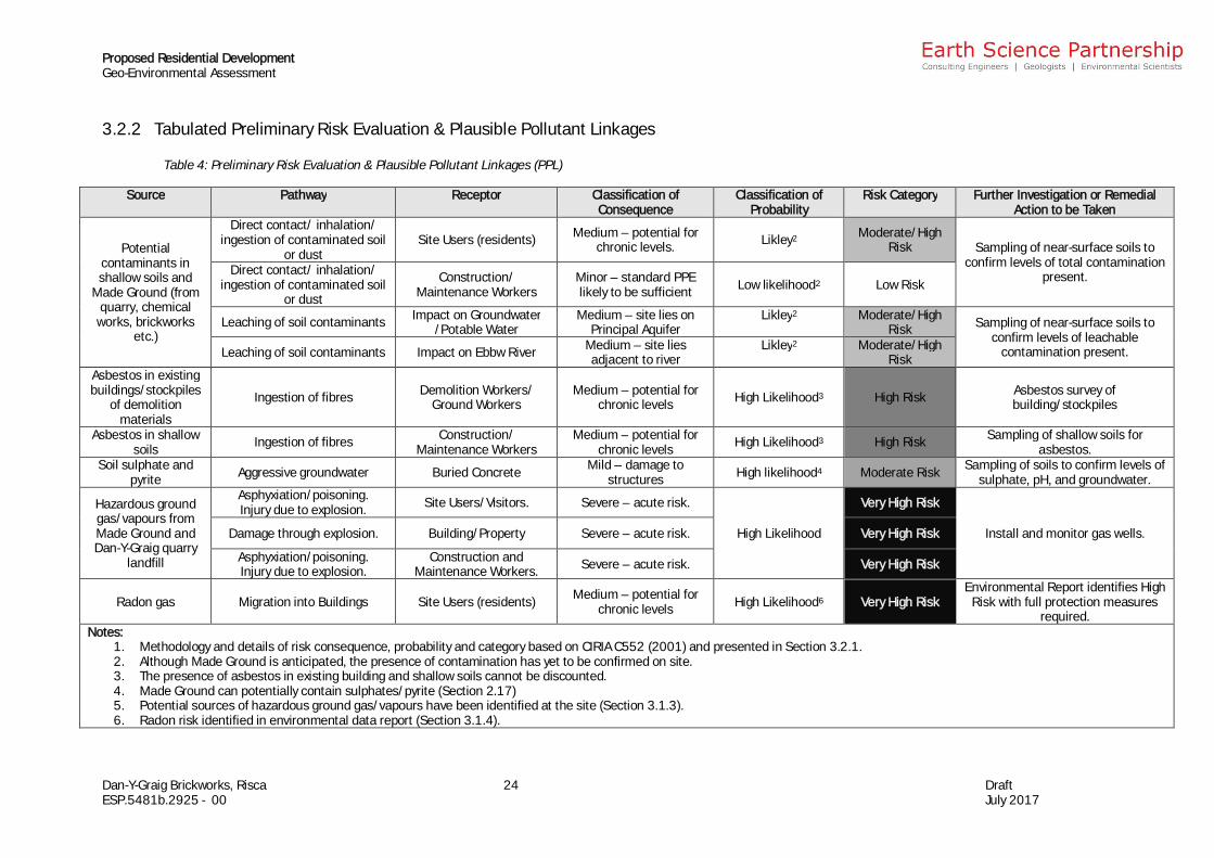
3.2.2 Tabulated Preliminary Risk Evaluation & Plausible Pollutant Linkages
Table 4: Preliminary Risk Evaluation & Plausible Pollutant Linkages (PPL)
Source Pathway Receptor Classification ofConsequence
Classification ofProbability
Risk Category Further Investigation or RemedialAction to be Taken
Potentialcontaminants inshallow soils and
Made Ground (fromquarry, chemical
works, brickworksetc.)
Direct contact/ inhalation/ingestion of contaminated soil
or dustSite Users (residents) Medium – potential for
chronic levels. Likley2 Moderate/HighRisk Sampling of near-surface soils to
confirm levels of total contaminationpresent.Direct contact/ inhalation/
ingestion of contaminated soilor dust
Construction/Maintenance Workers
Minor – standard PPElikely to be sufficient Low likelihood2 Low Risk
Leaching of soil contaminants Impact on Groundwater/Potable Water
Medium – site lies onPrincipal Aquifer
Likley2 Moderate/HighRisk Sampling of near-surface soils to
confirm levels of leachablecontamination present.Leaching of soil contaminants Impact on Ebbw River Medium – site lies
adjacent to riverLikley2 Moderate/High
RiskAsbestos in existingbuildings/stockpiles
of demolitionmaterials
Ingestion of fibres Demolition Workers/Ground Workers
Medium – potential forchronic levels High Likelihood3 High Risk Asbestos survey of
building/stockpiles
Asbestos in shallowsoils Ingestion of fibres Construction/
Maintenance WorkersMedium – potential for
chronic levels High Likelihood3 High Risk Sampling of shallow soils forasbestos.
Soil sulphate andpyrite Aggressive groundwater Buried Concrete Mild – damage to
structures High likelihood4 Moderate Risk Sampling of soils to confirm levels ofsulphate, pH, and groundwater.
Hazardous groundgas/vapours fromMade Ground andDan-Y-Graig quarry
landfill
Asphyxiation/poisoning.Injury due to explosion. Site Users/Visitors. Severe – acute risk.
High Likelihood
Very High Risk
Install and monitor gas wells.Damage through explosion. Building/Property Severe – acute risk. Very High Risk
Asphyxiation/poisoning.Injury due to explosion.
Construction andMaintenance Workers. Severe – acute risk. Very High Risk
Radon gas Migration into Buildings Site Users (residents) Medium – potential forchronic levels High Likelihood6 Very High Risk
Environmental Report identifies HighRisk with full protection measures
required.Notes:
1. Methodology and details of risk consequence, probability and category based on CIRIA C552 (2001) and presented in Section 3.2.1.2. Although Made Ground is anticipated, the presence of contamination has yet to be confirmed on site.3. The presence of asbestos in existing building and shallow soils cannot be discounted.4. Made Ground can potentially contain sulphates/pyrite (Section 2.17)5. Potential sources of hazardous ground gas/vapours have been identified at the site (Section 3.1.3).6. Radon risk identified in environmental data report (Section 3.1.4).
Proposed Residential DevelopmentGeo-Environmental Assessment
Dan-Y-Graig Brickworks, Risca 25 DraftESP.5481b.2925 - 00 July 2017
4 RECOMMENDED FURTHER WORK
We understand that the site development is to comprise the construction of residentialdwellings with associated areas of landscaping and hardstanding. We consider thatfurther investigation and assessment would be required or prudent prior todevelopment.
Based on the site history, it is likely that a phased investigation may be required toaddress all geoenvironmental and geotechnical hazards. Subsequent phases of workshould be scoped and determined from the preceding phase findings and an Exploratory(preliminary) Investigation should comprise:
· Review and confirmation of the undertaking of the required ecological surveys,including the potential for invasive species;
· Possible presence and extent of ACMs within existing buildings/stockpiles ofdemolition materials, including pre-demolition asbestos survey;
· The presence and make up of Made Ground across the site;
· The levels of total soil contaminants in the shallow soils and/or Made Ground;
· The levels of soil sulphate and whether pyrite is likely to be present;
· The volume change potential and/or compressibility including potential for slagto be present;
· The potential for ground gas on site and migration onto site from of site sources;
· Monitoring of groundwater levels, to determine the potential for shallowgroundwater;
· Steep slopes are present at the west and east boundaries and consideration willneed to be given to slope stability and stability of the site. This will need to takeinto account the potential effects of the proposed development and will requireinteraction with the scheme designer.
The findings and recommendations in this report will be update upon completion of thesite walkover.
The site history has recorded a number of potentially contaminative former usesincluding the current brickworks, rail/tramways, chemical works and quarry. Anappropriately designed investigation will require scoping utilising a full review of theinformation obtained as part of this Desk Study assessment.
Further guidance on these requirements and scope of intrusive investigations, can beprovided by this office once development proposals have been finalised. It should benoted that dependant on the arising conditions identified as part of the exploratory(preliminary) investigation subsequent phases of work may be required.
Proposed Residential DevelopmentGeo-Environmental Assessment
Dan-Y-Graig Brickworks, Risca 26 DraftESP.5481b.2925 - 00 July 2017
ReferencesBLACKMORE K, BRIERE DE L’ISLE B, GARROW D, JONSSON J, NORRIS M, TURRELL J, TREW J andWILCOX S. 2010. Guidance for the Selection of Water Supply Pipes to be Used in BrownfieldSites. UK Water Industry Research Ltd. Report ref. No 10/WM/03/21.
BRITISH GEOLOGICAL SURVEY (BGS). 2017. Website accessed January 2017.
BRITISH STANDARDS INSTITUTION (BSI). 2010. Code of Practice for Site Investigations.BS5930:1999+A2:2010. HMSO, London.
BRITISH STANDARDS INSTITUTION (BSI). 2013. Investigation of Potentially Contaminated Sites –Code of Practice. BS10175, HMSO, London.
COAL AUTHORITY. Website accessed May 2017.
CONSTRUCTION INDUSTRY RESEARCH & INFORMATION ASSOCIATION (CIRIA). 2001.Contaminated Land Risk Assessment – A Guide to Good Practice. CIRIA 552.
CONWAY B W, FORSTER A, NORTHMORE K J, and BARCLAY W J. 1980. South Wales CoalfieldLandslip Survey. Institute of Geological Sciences, London.
Department for Environment, Food and Rural Affairs (DEFRA) and the Environment Agency.2004. The Model Procedures for the Management of Land Contamination. R&D PublicationCLR11.
SCIVYER C. 2007. Radon: Guidance on Protective Measures for New Buildings. BRE 211.
WILSON S, CARD G and HAINES S. 2009. Ground Gas Handbook. Whittles Publishing.
Proposed Residential DevelopmentGeo-Environmental Assessment
Dan-Y-Graig Brickworks, Risca DraftESP.5481b.2925 - 00 July 2017
Appendix A Risk Evaluation Methodology
Dan-Y-Graig Brickworks, Risca DraftESP.5481b.2925 - 00 July 2017
The methodology set out in CIRIA C552 (2001), Contaminated Land Risk Assessment –A Guide to Good Practice, has been used to assess whether or not risks are acceptable,and to determine the need for collating further information or remedial action. Thefollowing tables have been used to classify the risk for each pathway. Tables A2 to A4have been revised to include for circumstances where no plausible risk has beenidentified.
Table A1 - Classification of Consequence
Classification Definition Examples
Severe
· Short-term (acute) risk to humanhealth likely to result in SignificantHarm.
· Short-term risk of pollution to asensitive water resource.
· Catastrophic damage tobuildings/property.
· Short-term risk to ecosystem, ororganism forming part of thatecosystem.
· High concentrations of Cyanideat surface of informalrecreation area.
· Major spillage of contaminantsfrom site into controlled water.
· Explosion causing buildingcollapse.
Medium
· Chronic damage to human health.· Pollution of sensitive water resource.· A significant change to ecosystem, or
organism forming part of thatecosystem.
· Contaminant concentrationsexceed assessment criteria.
· Leaching of contaminants toSecondary A aquifer.
· Death of species within naturereserve.
Mild
· Pollution of non-sensitive waterresources.
· Significant damage to crops,buildings, structures.
· Damage to sensitive buildings,structures or the environment.
· Pollution of Secondarygroundwater sources.
· Damage to building rendering itunsafe to occupy.
Minor
· Harm, although not necessarilysignificant harm, which may result infinancial loss, or expenditure toresolve.
· Non permanent risks to humanhealth (easily prevented by means ofPPE).
· Easily repairable effects of damageto buildings and structures.
· The presence of contaminantsat such concentrations thatPPE is required during siteworks.
· The loss of plants in alandscaping scheme.
· Discoloration of concrete.
Table A2: Classification of Probability
Classification Definition
HighLikelihood
There is a pollutant linkage and an event that either appears very likely in the shortterm and almost inevitable over the longer term. Or, there is already evidence at thereceptor of harm or pollution.
LikelyThere is a pollution linkage and all the elements are present and in the right place,which means that it is probable that an event will occur. Circumstances are such thatan event is not inevitable, but possible in the short term and likely over the longer term.
LowLikelihood
There is a pollutant linkage and circumstances are possible under which an event couldoccur. However, it is by no means certain that even over a longer period such an eventwould take place, and is less likely in the shorter term.
Unlikely There is a pollutant linkage, but circumstances are such that it is improbable that anevent would occur, even in the very long term.
No Linkage No plausible linkage has been established.
Dan-Y-Graig Brickworks, Risca DraftESP.5481b.2925 - 00 July 2017
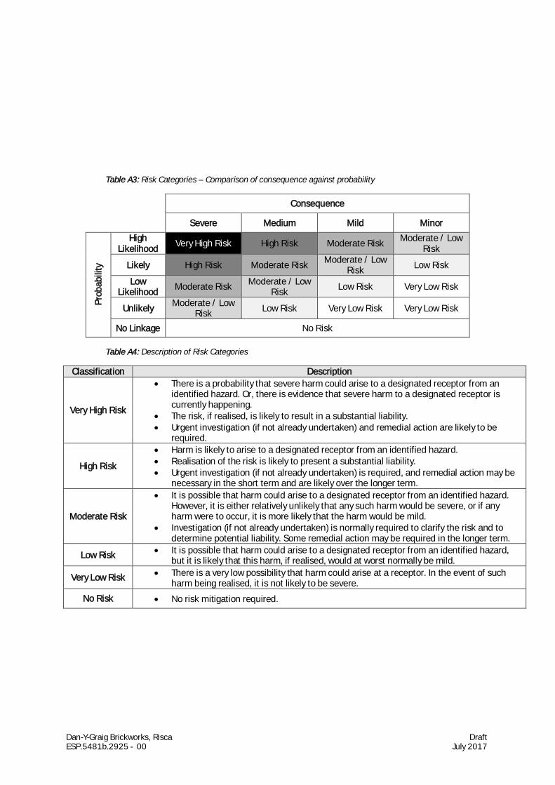
Table A3: Risk Categories – Comparison of consequence against probability
Consequence
Severe Medium Mild Minor
Prob
abili
ty
HighLikelihood Very High Risk High Risk Moderate Risk Moderate / Low
Risk
Likely High Risk Moderate Risk Moderate / LowRisk Low Risk
LowLikelihood Moderate Risk Moderate / Low
Risk Low Risk Very Low Risk
Unlikely Moderate / LowRisk Low Risk Very Low Risk Very Low Risk
No Linkage No Risk
Table A4: Description of Risk Categories
Classification Description
Very High Risk
· There is a probability that severe harm could arise to a designated receptor from anidentified hazard. Or, there is evidence that severe harm to a designated receptor iscurrently happening.
· The risk, if realised, is likely to result in a substantial liability.· Urgent investigation (if not already undertaken) and remedial action are likely to be
required.
High Risk
· Harm is likely to arise to a designated receptor from an identified hazard.· Realisation of the risk is likely to present a substantial liability.· Urgent investigation (if not already undertaken) is required, and remedial action may be
necessary in the short term and are likely over the longer term.
Moderate Risk
· It is possible that harm could arise to a designated receptor from an identified hazard.However, it is either relatively unlikely that any such harm would be severe, or if anyharm were to occur, it is more likely that the harm would be mild.
· Investigation (if not already undertaken) is normally required to clarify the risk and todetermine potential liability. Some remedial action may be required in the longer term.
Low Risk · It is possible that harm could arise to a designated receptor from an identified hazard,but it is likely that this harm, if realised, would at worst normally be mild.
Very Low Risk · There is a very low possibility that harm could arise at a receptor. In the event of suchharm being realised, it is not likely to be severe.
No Risk · No risk mitigation required.
Dan-Y-Graig Brickworks, Risca DraftESP.5481b.2925 - 00 July 2017
Appendix B Historical Maps
Dan-Y-Graig Brickworks, Risca DraftESP.5481b.2925 - 00 July 2017
Appendix C Enviro-Insight Environmental Data Report
Dan-Y-Graig Brickworks, Risca DraftESP.5481b.2925 - 00 July 2017
Appendix D Exploratory Hole Records from PreviousInvestigations (ESP 2005)
Dan-Y-Graig Brickworks, Risca DraftESP.5481b.2925 - 00 July 2017
Appendix E Coal Authority Mining Report

Dan-Y-Graig Brickworks, Risca DraftESP.5481b.2925 - 00 July 2017
Appendix F Correspondence with Caerphilly County Council
Dan-Y-Graig Brickworks, Risca DraftESP.5481b.2925 - 00 July 2017
Appendix G Borehole Records Available from the BritishGeological Survey (BGS, 2017)
Dan-Y-Graig Brickworks, Risca DraftESP.5481b.2925 - 00 July 2017
Appendix H Preliminary UXO Risk Assessment (Zetica, 2016)

Dan-Y-Graig Brickworks, Risca DraftESP.5481b.2925 - 00 July 2017