Cultural Resources Assessment - NASA
78
FINAL CULTURAL RESOURCES ASSESSMENT OF WALLOPS FLIGHT FACILITY ACCOMACK COUNTY, VIRGINIA Submitted to: National Aeronautics and Space Administration Goddard Space Flight Center Wallops Flight Facility Wallops Island, VA 23337 Submitted by: URS Group, Inc. and EG&G Technical Services, Inc. 200 Orchard Ridge Drive, Suite 100 Gaithersburg, MD 20878 NOVEMBER 2003
Transcript of Cultural Resources Assessment - NASA

FINAL
CULTURAL RESOURCES ASSESSMENT OF
WALLOPS FLIGHT FACILITY
ACCOMACK COUNTY, VIRGINIA
Submitted to:
National Aeronautics and Space Administration Goddard Space Flight Center Wallops Flight Facility Wallops Island, VA 23337
Submitted by:
URS Group, Inc. and
EG&G Technical Services, Inc. 200 Orchard Ridge Drive, Suite 100 Gaithersburg, MD 20878
NOVEMBER 2003

EXECUTIVE SUMMARY
i
EXECUTIVE SUMMARY
The National Aeronautics and Space Administration (NASA) Wallops Flight Facility (WFF) is an approximately 6000-acre facility located in Accomack County, on Virginia’s Eastern Shore. It is maintained by NASA Goddard Space Flight Center pursuant to a tri-fold mission of fostering: 1) scientific research regarding and enabled by orbital and sub-orbital space missions; 2) commercial use of space through advanced technology development; and 3) education in facility-related scientific and technological subjects through partnership and public outreach involving academia, industry and other government agencies. The facility was inaugurated as a NASA installation in 1959, transforming an earlier aircraft research facility that had initially been acquired by the U.S. government in the time between the World Wars and built in 1943. The present WFF now consists of three areas: Wallops Main Base (1,900 acres); Wallops Mainland (100 acres); Wallops Island (4,200 acres), the latter including 1,000 acres of land and 1,200 acres of tidal marsh area on the landward side of the island.
This study is an assessment-level investigation of the entire WFF and was sponsored by WFF to assist in meeting its obligations under Section 106 and Section 110 of the National Historic Preservation Act (NHPA) of 1966, as amended. Briefly, Section 106 addresses project impact issues and Section 110 addresses overall historic property resource inventory and stewardship issues. To conduct the study, URS cultural resource specialists undertook background research, windshield survey (archaeology and historic structures) and selective reconnaissance-level architectural survey. This study supercedes an earlier cultural resource assessment prepared on behalf of WFF in 1991; it implements necessary technical updates to the earlier study as well as addressing Virginia Department of Historic Resources (DHR/Virginia SHPO) comments on the earlier study. Further desk-based research and field reconnaissance are proposed as a follow up to the present study.
Technical components of the present study include: 1) an updated historic context, which primarily supports the archaeological assessment, for archaeological resources based on a current literature and inventory review; 2) an archaeological sensitivity model for the facility (based on the data review) that classifies areas as having low, moderate, or high archaeological sensitivity; 3) an overview assessment of facility structures for potential historic significance and integrity (condition); 4) a reconnaissance level recordation of selected structures that are representative of the facility’s “fifty-year-old and greater” property inventory and of two structures that are subject to planned removal in the near future; and 5) recommendations for future NRHP planning and compliance studies addressing both historic structures and archaeological resources.
Assessment results for archaeological resources and historic structures are briefly summarized as follows:
• Archaeological Sites. Six archaeological sites have been identified within the project area. These historic-period sites (44AC 103, 44AC405 and 44AC437) are located on the Main Base, one un-numbered prehistoric site is located on the Mainland, and two historic sites (44AC89 and 44AC 159) are located on Wallops Island. None of the known archaeological sites within the project area are currently in danger of disturbance or destruction. Areas that contain moderate and high archaeological sensitivity are located,

EXECUTIVE SUMMARY
ii
for the most part, along the fringes of the WFF. These areas are not likely to be disturbed or developed due to their location next to wetlands and ecological buffer zones. Ground disturbing processes limit the archaeological potential of many parts of WFF. These processes include past erosion by the wind and sea on Wallops Island and by construction and landscaping from mission-driven improvements in all parts of the facility. Nonetheless, un-surveyed areas should be considered in greater detail in future planning and inventory studies, which in some cases should include additional field verification. WFF has not yet been subject to a comprehensive archaeological identification survey, yet such a study may not be warranted, due to the extensive nature of the natural and cultural ground disturbances at the facility. Future intensive archaeological survey (Phase I survey) should be limited to areas of high archaeological sensitivity identified by the present study. Because of the planned maintenance of undisturbed buffer and wetland fringes (which encompass all areas of high archeological potential), project driven (Section 106) archaeological survey would most likely be limited to Phase IA type survey (record review and brief field confirmation) of any future projects’ proposed Area of Potential Effects (APE).
Historic Structures. The standing structures review confirmed that no buildings or structures at WFF are currently listed in the Virginia DHR’s inventory of historic properties. Likewise, none of the WFF buildings, structures or facilities is listed on the National Register of Historic Places, or is recognized as National Historic Landmarks. A total of 166 properties, however, are at least 50 years old. Ninety-nine of the considered WFF properties were built between 1936 and 1949, and the remainder built between 1950 and 1955. (The age criterion for consideration of an historic structure is 50 years; and, for planning purposes, the 1955-2005 date range is used by the study as the youngest applicable 50-year period.) Although none of the 166 structures has been evaluated for National Register eligibility, it is likely that the WEMA Recreational Facility (V-065), a former Coast Guard station, and the nearby Observation Tower (V-070) meet the National Register eligibility criteria, most probably under National Register Criterion C, which pertains to architectural or engineering design or construction. Numerous other structures among the 166, despite their historic interest, appear to have limited historic integrity at present due to renovations and mission-related improvements made after their initial construction dates.
Numbered recommendations of this study are presented in the report’s final text section in order of priority. The most important and time sensitive of these recommendations are:
Evaluate the former Coast Guard station (WEMA Recreational Facility/V-065) and former Navy Family Housing complex (example WFF Structure ID# H-016), both of which are planned for removal in FY 2004.
Initiate multi-year step-wise preparation of an Integrated Cultural Resource Management Plan (ICRMP), a document that will guide NHPA compliance and related DHR consultation in according to procedures that are integrated with the WFF planning process.

Table of C ontents
iii
EXECUTIVE SUMMARY ........................................................................................................... i
1.0 INTRODUCTION .................................................................................................................. 1-1
2.0 PROJECT LOCATION AND DESCRIPTION .................................................................. 2-1
2.1 Physical Environment ....................................................................................................... 2-1 2.2 Natural Environment ......................................................................................................... 2-2 2.3 Present Land Use ............................................................................................................... 2-3
3.0 CULTURE CONTEXT .......................................................................................................... 3-1
3.1 Prehistoric Context ............................................................................................................... 3.1.1 Paleoindian Period (10,000 – 8000 BC) .................................................................... 3.1.2 Archaic Period (8000 – 1000 BC) ............................................................................. 3.1.3 Woodland Period (1000 BC – AD 1600) ................................................................... 3.1.4 Contact Period (ca. AD 1600) ....................................................................................3.2 Historic Context ..........................................................................................................3-15 3.2.1 Settlement to Society (AD 1607 – 1750)............................................................3-16 3.2.2 Colony to Nation (AD 1750 – 1789) .................................................................3-18 3.2.3 Early National Period (AD 1789 – 1830) ..........................................................3-21 3.2.4 Antebellum Period (AD 1830 – 1860)................................................................3-22 3.2.5 Civil War Period (AD 1860 – 1865) ...................................................................3-24 3.2.6 Reconstruction and Growth (AD 1865 – 1917)..................................................3-25 3.2.7 World War I to World War II (AD 1917 – 1945) ...............................................3-28 3.2.8 The New Dominion (AD 1945 – present) ..........................................................3-313.3 Previous Investigations ...............................................................................................3-32 3.3.1 Archaeology ........................................................................................................3-34 3.3.2 Historic Structures .............................................................................................3-36
4.0 RESEARCH DESIGN ........................................................................................................... 4-1
4.1 Objectives ......................................................................................................................... 4-1 4.2 Methods ............................................................................................................................ 4-1
4.2.1 Background Research .............................................................................................. 4-1 4.2.2 Archaeology Methods and Expected Results .......................................................... 4-2 4.2.3 Historic Structures Survey Methods and Expected Results ...................................... 4-3
5.0 RESULTS OF ARCHAEOLOGICAL SENSITIVITY ASSESSMENT .......................... 5-1
5.1 Predictive Model .............................................................................................................5-1 5.1.1 Prehistoric Site Predictive Model ........................................................................5-1 5.1.2 Historic Site Predictive Model ..............................................................................5-35.2 Sensitivity Assessment ...................................................................................................5-7 5.2.1 Wallops Main Base ...............................................................................................5-7 5.2.2 Wallops Mainland ....................................................................................................... 5.2.3 Wallops Island ...........................................................................................................
6.0 RESULTS OF HISTORIC STRUCTURES ASSESSMENT ............................................ 6-1
7.0 RECOMMENDATIONS ...................................................................................................... 7-1
7.1 Historic Structures ............................................................................................................ 7-1

Table of C ontents
v
7.2 Archaeology ..................................................................................................................... 7-3 7.3 Comprehensive Plannning ................................................................................................ 7-4
8.0 REFERENCES CITED ......................................................................................................... 8-1
FIGURES AND PLATES APPENDIX A: QUALIFICATIONS OF INVESTIGATORS APPENDIX B: KNOWN ARCHAEOLOGICAL SITES LOCATED WITHIN AN 8-KM
(5-MILE) RADIUS OF THE WFF APPENDIX C: HISTORIC PROPERTIES LOCATED WITHIN A 3-KM (2-MILE)
RADIUS OF THE WFF APPENDIX D: FIELD NOTES AND DIGITAL PHOTOGRAPHS OF
REPRESENTATIVE BUILDINGS APPENDIX E: VIRGINIA DEPARTMENT OF HISTORIC RESOURCES
RECONNAISSANCE LEVEL DATA SHARING SYSTEM (DSS) SURVEY FORMS
APPENDIX F: SECTION 110 GUIDELINES
LIST OF TABLES
Table 3-1. Prehistoric Culture Chronology ................................................................................... 3-1 Table 3-2. Historic Culture Chronology ..................................................................................... 3-16 Table 3-3. Summary of Archaeological Sites by Time Period ................................................... 3-35 Table 3-4. Known Archaeological Sites Located Within the Project Area ................................ 3-35 Table 3-5. Summary of Historic Properties by Time Period ...................................................... 3-36 Table 5-1. Lowery’s 10 Archaeological Site Location Types for the Delmarva Peninsula ......... 5-2 Table 5-2. Prehistoric Site Predictive Model for the Project Area ............................................... 5-3 Table 5-3. Historic Site Predictive Model for the Virginia Interior Coastal Plain ...................... 5-4 Table 5-4. Non-Maritime Historic Site Predictive Model for the Project Area ........................... 5-6 Table 5-5. Maritime Historic Site Predictive Model for the Project Area .................................... 5-6 Table 5-6. Changes in Number of Structures ............................................................................... 5-7 Table 6-1. Potential Historic Properties At Least 50 Years Old or Older ................................... 6-1 Table 6-2. Six Resources Surveyed at Reconnaissance Level ...................................................... 6-2

Table of C ontents
v
LIST OF FIGURES
Figure 1: Project Location Figure 2: Location of Wallops Flight Facility Figure 3: Ferrar ca. 1667 Map Figure 4: St. Thomas of Jenifer 1693 Map Figure 5: West and Johnson 1829 Map Figure 6: Crozet 1849 Map Figure 7: Lloyd 1862 Map Figure 8: 1882 Nautical Chart Figure 9: 1892 Nautical Chart Figure 10: 1896 Postal Routes Map Figure 11: 1933 Nautical Chart Figure 12: 1966 Nautical Chart Figure 13: 1942 Map of Chincoteague Auxiliary Naval Air Station Figure 14: 1950 Map of Chincoteague Auxiliary Naval Air Station Figure 15: 1957 Map of Chincoteague Auxiliary Naval Air Station Figure 16: Main Base Sensitivity Map for Prehistoric Archaeological Sites Figure 17: Main Base Sensitivity Map for Historic Archaeological Sites Figure 18: Mainland Sensitivity Map for Prehistoric Archaeological Sites Figure 19: Mainland Sensitivity Map for Historic Archaeological Sites Figure 20: Wallops Island (North) Sensitivity Map for Prehistoric Archaeological Sites Figure 21: Wallops Island (North) Sensitivity Map for Historic Archaeological Sites Figure 22: Wallops Island (South) Sensitivity Map for Prehistoric Archaeological Sites Figure 23: 1880 Nautical Chart Figure 24: 1933 Nautical Chart Figure 25: 1958 Nautical Chart Figure 26: 1968 Nautical Chart Figure 27: 1980 Nautical Chart Figure 28: 1984 Nautical Chart Figure 29: Wallops Island (South) Sensitivity Map for Historic Archaeological Sites Figure 30: Main Base Facilities Figure 31: Wallops Island Facilities
LIST OF PLATES
Plate 1: Plate 2: Plate 3: Plate 4: Plate 5: Plate 6: Plate 7: Plate 8:
Office and Research Facility on Wallops Main Base Tracking Antennae on Wallops Main Base Distant View of Airfield at Wallops Main Base Hangar at Wallops Main Base Airfield View of Marsh Area on Wallops Mainland Transmitter Building on Wallops Mainland Mission Facilities on Wallops Island View to North Along Wallops Island Breakwater


1-1
O N E SECTIONIntroduction
1.0 INTRODUCTION
Under contract to the National Aeronautics and Space Administration (NASA) and Goddard Space Flight Center (GSFC), Wallops Flight Facility (WFF) URS Group, Inc./EG&G (URS), conducted an archaeological sensitivity assessment and selective historic structures reconnaissance of the Wallops Flight Facility in Accomack County, Virginia. The project area is located on the Atlantic Ocean side of the Eastern Shore of Virginia (Figure 1). The approximately 6,000-acre project area encompasses the Wallops Main Base, Wallops Mainland, and Wallops Island.
The cultural resources assessment was conducted to assist the WFF in meeting its obligations under Section 106 and Section 110 of the National Historic Preservation Act of 1966, as amended. The overall purpose of the reconnaissance effort is to comply with direction received from the Virginia Department of Historic Resources (DHR, which also functions as the State Historic Preservation Office [SHPO]) in response to previous studies prepared for WFF property, and to provide a basis for managing cultural resources at the WFF in compliance with all requirements of Section 106 and Section 110. The ultimate compliance objective is to develop an Integrated Cultural Resources Management Plan (ICRMP) that is applicable to the entire WFF. The present study is a step in the direction of ICRMP development that is planned for completion within two additional years beyond the present effort. The effort was designed to meet the study and reporting standards of the Secretary of the Interior as specified in the Standards and Guidelines for Archaeology and Historic Preservation (Federal Register, Vol. 48, No. 190, 1983), and the Virginia DHR’s (2003) revised Guidelines for Archaeological Investigations in Virginia.
The study was conducted from June through September of 2003. Project background research and fieldwork were conducted by URS Group staff who meet or exceed the Secretary of the Interior’s Professional Qualification Standards (36 CFR 61). Emlen Myers, Ph.D., served as Principal Investigator and Project Manager, and Kathleen A. Furgerson served as Senior Archaeologist. Robert D. Wall, Ph.D., provided technical guidance on archaeological issues. Justin Patton conducted background research. Mark R. Edwards, Senior Architectural Historian, conducted the historic structures assessment and served as Principal Investigator for architectural history. The qualifications of the investigators are summarized in Appendix A.
Including this Introduction (1.0) the report contains seven sections of text: Project Area Location and Description (2.0), Culture Context (3.0), Research Design (4.0), Results of Archaeological Sensitivity Assessment (5.0), Results of Historic Structures Assessment (6.0), and Conclusions and Recommendations (7.0). References Cited (8.0) follow the body of the report. The figures and plates are attached following the text sections. Appendices follow the figures and plates, and include: Appendix A, Qualifications of Investigators; Appendix B, Known Archaeological Sites Located Within a 8-km (5-mile) Radius of the WFF; Appendix C, Historic Properties Located Within a 3-km (2-mile) Radius of the WFF; Appendix D, Field Notes and Digital Photographs of Representative Buildings and Navy Family Housing Variants; Appendix E, Virginia Department of Historic Resources Reconnaissance Level Data Sharing System (DSS) Survey Forms; and Appendix F, Section 110 Guidelines.

T W O SECTIONProject Location And Description
1-2
2.0 PROJECT LOCATION AND DESCRIPTION
The WFF is located on the Delmarva Peninsula in the northeastern portion of Accomack County, Virginia (Figure 2). The Delmarva Peninsula is bordered by the Atlantic Ocean to the east and the Chesapeake Bay to the west. The WFF is located approximately 8 kilometers (5 miles) west of Chincoteague Island. The WFF project area consists of three areas totaling approximately 6,000 acres: the Wallops Main Base (2,230 acres); the Wallops Mainland (100 acres), and Wallops Island (4,200 acres), which includes approximately 1,000 acres of tidal marsh. The Main Base is located off Virginia Route 175 and approximately 3.2 kilometers (2 miles) east of U.S. Route 13 (NASA 1999). The entrance gate for the Wallops Mainland and Wallops Island is located approximately 11 kilometers (7 miles) south of the Main Base (NASA 1999).
As an environmental basis for understanding past human occupation of the area, this section summarizes the physical and natural settings, as well as present land use of the project area.
2.1 PHYSICAL ENVIRONMENT
The project area lies “in the Tidewater region of the Embayed section of the Atlantic Coastal Plain” Physiographic Province (United States Department of Agriculture, Soil Conservation Service [USDA:SCS] 1994:3). Three major landforms are found in Accomack County: mainland, tidal marsh, and barrier island. All three are found in the WFF project area. The mainland includes low and high terraces separated by a discontinuous escarpment at 25 feet above mean sea level (amsl). Low terraces are found west of Route 13 (outside the project area) and on the extreme eastern edge of the mainland. The low terrace “consists of broad to narrow flats bordered by tidal marshes on the east and a discontinuous escarpment on the west” (USDA, SCS 1994:3). The high terrace ranges in elevation from 25 to 50 feet amsl. The high terrace topography is more complex than the low terrace, and “is generally characterized by broad, nearly level terraces that are broken by narrow elliptical ridges [Carolina Bay features], gentle escarpments, tidal creeks, and drainageways” (USDA, SCS 1994:72). Extensive tidal marshes are located between the mainland and barrier islands. The marshes flood regularly with the tides, are drained by an extensive system of meandering creeks, and have immature soils. Barrier islands are roughly parallel to the mainland and are generally less than 10 feet amsl. Topography varies from nearly level to steep, and soils are immature and vary widely from very poorly to excessively drained (USDA, SCS 1994).
The majority of the WFF Main Base is located on a high terrace landform (25 to 40 feet amsl) with the northern and eastern portions located on low terrace (0 to 25 feet amsl) and tidal marsh. The Wallops Mainland is primarily located on low terrace (0 to 25 feet amsl) and tidal marsh, and Wallops Island is a barrier island with extensive tidal marshes between the island and the Wallops Mainland.
The area is underlain by Quaternary Period (ca. two million years ago to present) sands, gravels, silts, and clays (Bailey 1999; United States Geological Survey [USGS] 1973). The surface geology of the project area varies somewhat according to landform. The Accomac Member of the Omar Formation is found on the mainland, and consists of sand, gravel, silt, clay, and peat

T W O SECTIONProject Location And Description
2-3
deposits (USGS 1973). Tidal marsh areas are underlain by Joynes Neck Sand, a fine to coarse-grained sand that coarsens downward to gravel and sand. Tidal marsh areas also include organic-rich silts and clays. The barrier islands contain beaches and dunes that are composed of fine to coarse-grained quartz sands that are poorly to well-sorted (USGS 1973).
Soils in Accomack County were formed from parent material consisting of transported sediments moved and deposited by marine and stream action (USDA, SCS 1994). Within the project area, soils mapped for the terraces include Bojac, Nimmo, Molena, and Polowana series. These soils are sands and sandy loams that vary from fine to coarse in texture. Soils mapped for the tidal marshes within the project area include Chincoteague and Magotha series. Chincoteague soils are gleyed silt loams. Magotha soils are also gleyed silt loams, but are located in higher elevations within the marshes and have a mature soil profile. These areas were former uplands before they were transformed to tidal marsh by rising sea levels. Soils mapped for the barrier island in the project area (i.e., Wallops Island) include beaches, the Camocca series and the Fisherman-Assateague complex. Beaches are unconsolidated sands with no soil development. The Camocca series and Fisherman-Assateague complex soils formed from sandy sediments and are immature soils as indicated by the absence of surface pedogenic horizons (i.e., there is no A Horizon overlying parent materials).
The lack of soil development on Wallops Island reflects the dynamic environment typical of barrier islands. On the Delmarva Peninsula, barrier island shorelines are constantly migrating inland. As the Atlantic Ocean-side is eroding, sand is deposited behind the active dunes on the landward-side of the island. This process leads to erosion of the former land surface on the Atlantic Ocean side of the island, and burial of the former land surface by dune migration on the landward side of the island (Fehr et al. 1988). On Wallops Island, these soil disturbing processes have been slowed through recent human intervention (e.g., emplacement of seawall and facility construction on the island). In addition to the dynamics of barrier island formation, sea level rise during the Holocene has led to inundation of formerly dry land surfaces and extensive development of tidal marshes between the barrier islands and the mainland. The northern end of the island has been building towards Chincoteague Island over the past one hundred years. In addition, at the southern end of the island, Assawoman Inlet, which separates Assawoman Island from Wallops Island, was filled in 1986 due to a storm (NASA 1999). The inlet was temporarily reopened in 1987, but has since filled in again. These changes reflect the dynamic nature of barrier island environments. The Wallops Main Base and Mainland have been protected from tidal erosion due to the presence of the barrier islands and tidal marshes, and are not subject to the same dynamic forces that affect barrier islands.
2.2 NATURAL ENVIRONMENT
Vegetation for the area varies with landform association. On the Wallops Main Base and Wallops Mainland (mainland landform) areas include loblolly pine, black cherry, red maple, black willow, sassafras, and wax myrtle (NASA 1999). Wallops Island (barrier island landform) vegetation includes seabeach orach, common saltwort, sea rocket, American beachgrass, seaside goldenrod, northern bayberry, wax myrtle, groundsel-tree, phragmites, poison ivy, greenbriar, loblolly pine, cherry, and duckweed (NASA 1999). The tidal marsh areas between Wallops Island and the mainland are dominated by saltmarsh cordgrass and salt meadow cordgrass

T W O SECTIONProject Location And Description
2-4
(NASA 1999). Areas of marsh are also located along Mosquito Creek on the northern fringe of the Main Base area (NASA 1999). Areas of lawn are maintained in all three areas of the WFF.
Both terrestrial and aquatic faunal species are found throughout the WFF (NASA 1999). Invertebrate species include a variety of insects, snails, and crabs. In addition, sand shrimp, moon jelly, and squid are also found. Fish species include sandshark, smooth dogfish, smooth butterfly ray, bluefish, pipefish, spot, croaker, sea trout, and flounder. Amphibian and reptile species include Fowler’s toad, green tree frog, black rat snake, hognose snake, box turtle, and northern fence lizard. Several species of sea turtle and whales are also found in the waters of the area. Bird species include several species of sparrows and gulls, red-winged blackbird, boat-tailed grackle, fish crow, gray catbird, mourning dove, swallows, mockingbirds, robins, and starlings. Migratory birds include numerous species of ducks, geese, shorebirds, and songbirds. Predatory birds (raptors) include the osprey, bald eagle, and peregrine falcon. Mammalian species include white-tailed deer, raccoon, red fox, white-footed mouse, meadow vole, opossum, gray squirrels, and cottontail rabbit (NASA 1999).
2.3 PRESENT LAND USE
The Wallops Main Base was developed as a flight training center by the U.S. Navy in 1940s (NASA 2002). NASA acquired the property in 1959, as well as the Mainland property, and continues to operate the runways. The Main Base also houses research facilities, operations centers, and permanent orbital and suborbital tracking centers. The Mainland provides access to Wallops Island (via a causeway across the tidal marshes), and contains Doppler radar and tracking facilities. The National Advisory Committee for Aeronautics (NACA) authorized the Langley Research Center in 1945 to proceed with development of Wallops Island as a site for rocket propelled models. This was an essential step in the nation’s efforts to conduct aerodynamic research at high speeds, leading to advances in aeronautics and space science. NASA acquired the property in 1958 and continues to operate its runways. Launch sites are still located on the island, and are actively used today (NASA 2002). In addition to current use by NASA, through cooperative agreements the WFF is also used by the U.S. Navy, Virginia Commercial Space Flight Center, National Oceanic and Atmospheric Administration (NOAA), and the U.S. Coast Guard.
The majority of the WFF has been subject to continuous change and development since its founding in the 1 940s. Changes to the property include frequent construction, upgrade, and removal of structures and facilities caused by technological developments and advances in rocket science and related fields. Few undeveloped areas remain on the WFF, and those areas are located along the fringes of the property, and for the most part, in the tidal marshes (though dredging activities have occurred in some areas adjacent to the Main Base and Mainland). Wooded areas are located in the southern and northern portions of the Main Base, as well as the northern portions of Wallops Island. Plates 1 through 8 illustrate the different settings of the WFF.

T H R E E SECTIONCulture Context
3-5
3.0 CULTURE CONTEXT
The Virginia DHR has developed a chronological framework for the prehistory and history of the Commonwealth. This framework provides the basis for understanding prehistoric and historic cultural developments in the area, as well as providing a context for predicting the types and kinds of archaeological sites expected in the project area. Included in this background section are Prehistoric Context, Historic Context, and Previous Investigations sections.
3.1 PREHISTORIC CONTEXT
Based on survey and planning work conducted in the Commonwealth, as well as research conducted in the region, the DHR has defined three major time periods of prehistory: the Paleoindian Period (10,000 – 8000 BC), the Archaic Period (8000 – 1000 BC), and the Woodland Period (1000 BC – AD 1600). Table 3-1 summarizes the chronology of these periods. The Archaic and Woodland Periods are further subdivided into Early, Middle, and Late Periods, which are characterized by changes in material culture (e.g., projectile point or “arrowhead” styles), environmental adaptation, subsistence strategies (e.g., hunting and gathering, fishing, and horticulture), settlement patterns, technology, and socio-political configurations. Each major time period is discussed below, along with relevant data concerning settlement and subsistence patterns that have been established by previous excavation and study of archaeological sites in the Coastal Plain.
Table 3-1. Prehistoric Culture Chronology
Culture Period Sub-Period Date Ranges
Paleoindian n/a 10,000 – 8000 BC
Early 8000 – 6500 BC
Archaic Middle 6500 – 3000 BC
Late 3000 – 1000 BC
Early 1000 BC – AD 300
Woodland Middle AD 300 – AD 1000
Late AD 1000 – AD 1600
Contact n/a ca. AD 1600
3.1.1 Paleoindian Period (10,000 – 8000 BC)
The first habitation of the region began approximately 12,000 years ago with the influx of people who practiced a hunting and foraging lifestyle. While there may be evidence of human occupation in western North America and South America before 10,000 – 12,000 BC, there is no conclusive evidence in the Middle Atlantic region for human occupation before the Paleoindian Period. There is, however, a great deal of debate over the issue of a “pre-Clovis” culture in the Americas that predates the traditional “Clovis” culture of the Paleoindian Period. Archaeological sites such as Cactus Hill in Virginia (e.g., McAvoy and McAvoy 1997),
T H R E E SECTIONCulture Context
3-6
Meadowcroft Rockshelter in southwestern Pennsylvania (e.g., Adovasio et al. 1978), and the Topper Site in South Carolina (e.g., Parfit 2000; Rose 1999) have provided tantalizing but inconclusive evidence for human occupations predating the Paleoindian Period. There is currently no evidence for pre-Paleoindian occupations on the Delmarva Peninsula although shifts in survey strategies in recent decades (e.g. Lowery 2001, 2003) have resulted in new discoveries that may change the focus of research in this area. There are also extensive aeolian soils on the coastal plain that may cover more ancient fluvial sediments (Foss et al. 1978). Some of the depositional contexts may eventually reveal buried Paleoindian or pre-Paleo occupations. The discussion below focuses on the widely accepted definition of the Paleoindian culture in the Middle Atlantic region.
The end of the Pleistocene epoch (ca. 12,000 – 10,000 years ago) represents the terminus of the Ice Age or at least the beginning of a long interglacial episode. The environment during this time was quite different from modern conditions. Moisture that was locked up in the glacial ice sheets resulted in lower sea levels, and more exposure of land area along coastal areas. Areas that were exposed during this time were subsequently inundated by the global rise in sea level that began at the end of Pleistocene when climatic amelioration resulted in melting continental ice sheets. During this period of post-glacial warming, the climate was probably three to eight degrees Celsius colder than at present and the vegetation consisted of an open spruce parkland forest composed of spruce, pine, fir and alder (Brush 1986:149; Owens et al. 1974; Sirkin et al. 1977).
The Paleoindian toolkit included fluted projectile points, which were typically manufactured from high-quality lithic materials chosen for their predictable and consistent flaking properties. Projectile point types include Clovis, Cumberland/Barnes, Crowfield, Hardaway-Dalton, and Hardaway Side-Notched (Dent 1995; Lowery 2001, 2003). Other tools in the Paleoindian toolkit include endscrapers, sidescrapers, gravers, burins, denticulates, knives, pieces esquillées, wedges, perforators, and generalized unifaces and bifaces (Dent 1995).
Preferred lithic materials for these projectile points were high-quality cryptocrystalline rock such as jasper and chert (Brown 1979; McCary 1984), though tools made from locally available quartz and quartzite cobbles have been documented at sites in the Middle Atlantic region (e.g., Ebright 1992; McAvoy and McAvoy 1997). Archaeologists have postulated that Paleoindian hunter-gatherers traveled long distances to obtain raw materials for tool production (e.g., Custer 1984a; Gardner 1977). Recent research, however, has documented the availability of high-quality cherts and jasper cobbles in the Coastal Plain (e.g., Lowery 2001, 2003), suggesting that Paleoindians did not necessarily travel long distances to obtain lithic raw materials.
Paleoindian Period settlements consisted of seasonally-occupied camps, from which forays were made to obtain specialized resources, such as stone for tool manufacture (Custer 1 984a; Dent 1995; Gardner 1977). Site types postulated for the Paleoindian Period include base camps, quarry sites, quarry reduction stations, quarry-related base camps, base camp maintenance stations, outlying hunting stations, and isolated projectile point finds (Custer 1989; Gardner 1979). These site types are considered part of the “seasonal round” of Paleoindian settlement patterning.

T H R E E SECTIONCulture Context
3-7
The isolated point find is the most common of these manifestations and the distribution of such finds on the Delmarva peninsula shows a concentration on the mid-peninsular drainage divide where bay-basin features represent Pleistocene surface water sources (Custer 1989:29). This is not to say that other areas were not frequented; perhaps it simply reflects the availability of more exposed acreage for occupation in the middle of the peninsula. These sites are in headwater areas from which streams flow to the bay as well as the ocean side of the peninsula. Davidson (1981) also notes the use of interior drainages during this period, a trend that continues though the Middle Archaic. On the lower Delmarva peninsula, one fluted point site is recorded in Virginia (Custer 1989:93), although this is not noted in McCary’s (1984) fluted point survey.
Custer (1984a, 1989) classifies upper Delmarva Paleoindian sites within the Delaware Chalcedony Complex which focuses on outcrops of high quality cryptocrystalline lithic raw materials, specifically Delaware chalcedony. While focused on these high quality lithic resources, settlement patterns also focused on resources of upland or interior swamps, headwater zones and similar early Holocene environmental settings.
Paleoindian subsistence patterns are difficult to discuss for the Middle Atlantic region due to the paucity of recovered faunal and floral remains. Paleoindians in the western United States are considered to be “big game” hunters of extinct Pleistocene megafauna such as the mammoth, caribou, musk ox, and giant beaver. There is no concrete evidence for a similar subsistence pattern in the Middle Atlantic region, though megafaunal remains have been recorded in the area (Custer 1989; Dent 1995; Edwards and Merrill 1978; Kraft and John 1978; Lowery 2001, 2003). Paleoindians in this area likely subsisted on mammals such as white-tailed deer, caribou and moose, along with smaller mammals. While Paleoindian subsistence probably focused on hunted game, there is evidence to suggest that plant foods and fish were also important food resources (Dent 1995; McNett l985). It should also be noted that a rich array of megafauna (e.g., mammoth, mastodon, walrus, and ground sloth ) recovered from the continental shelf of the east coast may represent some of the key species that were hunted at the end of the Pleistocene (Edwards and Merrill 1977). One of the mammoth finds, for example, comes from the outer edge of the coastal plain in the lower Delmarva peninsula area of Virginia (Edwards and Merrill 1977:11).
Paleoindian sites are not widely known in the Virginia Coastal Plain. Much of what archaeologists know about Paleoindians comes from isolated finds of fluted projectile points. Few intact Paleoindian sites have been identified in the region (Dent 1995; Lowery 2001, 2003), however, dozens of isolated fluted point finds have been documented on the Delmarva Peninsula (e.g., Custer 1989; Dent 1995). The Paw Paw Cove site, located in the northern Chesapeake Bay area in Maryland, is currently the only excavated Paleoindian site on the Delmarva Peninsula (Dent 1995; Lowery 2001, 2003). One theory explaining the lack of documented Paleoindian sites is that they are located on the Continental Shelf of the Atlantic Ocean in areas that would have been dry land during the Paleoindian Period (e.g., Dent 1995; Lowery 2001, 2003).
No Paleoindian sites or fluted point finds have been documented in, or near, the project area. Brown’s (1979) survey of fluted points in nearby Maryland documents a fluted point in Worcester County, located some 25 kilometers (15 miles) north of the WFF project area. The point was a proximal section of a quartz Clovis point, recovered from 68 cm below the ground

T H R E E SECTIONCulture Context
3-8
surface in an excavation unit on the Nassawango site (Brown 1979:35). In Somerset County, Maryland, a number of fluted points have been found by collectors in tidal areas and islands in the Chesapeake Bay such as Smith Island. These are most likely from what were formerly Susquehanna River terrace edge surfaces at the end of the Pleistocene.
3.1.2 Archaic Period (8000 – 1000 BC)
The Archaic Period dates to ca. 10,000 to 3000 years ago, and is conventionally sub-divided into the Early (8000 – 6500 BC), Middle (6500 – 3000 BC), and Late (3000 – 1000 BC) Sub-Periods. In the Middle Atlantic area, Archaic sites are much more numerous, larger, and richer in artifacts than the earlier Paleoindian sites. They represent a series of adaptations that were increasingly sedentary and focused on the resources available along large rivers and major tributaries. Other, often smaller, sites of this period located away from the main streams probably represent seasonal or other specialized activities. Increasing territoriality and regional diversity are reflected in the varieties of artifacts, especially projectile points, throughout the Archaic Period. Evidence from Paleoindian and Early Archaic sites suggest that the transition from the Paleoindian way of life was not a sharp break, but rather a gradual transition (Custer 1990).
This transition was associated with a major climatic change that marks the end of the Pleistocene and beginning of the Holocene. The cool and moist climate of the late Ice Age shifted to a warmer and drier climate that approximates that of today. Rising sea levels inundated the lower Susquehanna River Valley and began forming the Chesapeake Bay estuary and its large salt and brackish water marshes, habitats that provided a rich and diverse subsistence base (Kraft 1976). As temperatures increased during the early Holocene, vegetation in the region shifted from coniferous forests of spruce to mixed deciduous/coniferous forests of hemlock, birch, hickory, and oak (Brush 1986:149; Custer 1990:10; Owens et al. 1974; Sirkin et al. 1977). After 7000 BC the spread of deciduous woodlands into upland areas, which previously had been predominantly spruce, hemlock, and pine forests, opened up new habitats to be exploited by animals and humans (Custer 1990).
3.1.2.1 Early Archaic Period (8000 – 6500 BC)
During the Early Archaic Period, environmental conditions were not drastically different from Paleoindian times. Glacial recession continued and deciduous forests expanded, possibly leading to a greater proliferation of temperate fauna. The most distinctive cultural characteristic of the Early Archaic was the appearance of notched projectile points, most notably the Palmer and Kirk varieties. There was a continuation in the Paleoindian tradition of using high quality cryptocrystalline lithic materials until the end of the Early Archaic Period when lower quality quartz and quartzite materials were more frequently used. Archaeological investigations in the Patuxent River drainage showed that the majority of Kirk points found were made of rhyolite. This indicates that by the Kirk phase, people traveled long distances in order to obtain the preferred lithic raw materials, or that by this time long-range trade networks had been established (Steponaitis 1980:68). Although rhyolite is certainly exploited as a lithic raw material by this time, it still does not represent the intensive use evident by Late Archaic times.

T H R E E SECTIONCulture Context
3-9
During the Early Archaic Period, and into the Middle Archaic Period, there was significant innovation in stone tool kits. Stemmed and side-notched serrated projectile points replaced the fluted projectile point varieties. The variety of projectile points associated with these periods indicate possible changes in subsistence strategies and exchange networks, and a possible regionalization of cultural traditions. Projectile point styles characteristic of the period include: corner-notched, serrated point styles such as Kirk, Palmer, Charleston, Lost Lake, Decatur, Amos, Kessel, and Fort Nottoway/Thebes; and stemmed points such as the Kirk stemmed and Pequea types (Custer 1984a, 1989, 1996; Dent 1995; Lowery 2001, 2003). Other tool types characteristic of Early Archaic Period assemblages include grinding slabs, milling stones, nutting stones, chipped stone adzes, wedges, perforators, knives, scrapers, as well as unifacial and bifacial tools (Dent 1995; Lowery 2001, 2003).
Early Archaic Period inhabitants continued to show a preference for high-quality lithic materials, either transported into the area through trade or travel, or obtained from cobble sources in river and stream beds, though some researchers (e.g., Lowery 2001, 2003) have noted that Early Archaic people appear to have a preference for non-local cherts, chalcedonies, and jaspers. In addition, several researchers have noted the increased use of rhyolite for tools during this period (e.g., Custer 1984a, 1986; Dent 1995; Lowery 2001, 2003).
Both Gardner (1974) and Custer (1980) have hypothesized that during the Early Archaic Period, people banded together into macro-base camps, or groups of families, in the spring and summer, and dispersed into smaller micro-base camps in the fall and winter months. The larger base camps were located in the valley floodplains while the smaller autumn and winter encampments were located in upland regions.
There is little faunal evidence from archaeological sites dating to the Early Archaic period, though “it is assumed that this environment supported bear, deer, elk, and a variety of small game adapted to a northern climate” (Kavanagh 1982:9). One exception is the Cactus Hill site (44SX202) which contains the remains of species that are still common in the region today (Whyte 1995). Floral evidence from sites such as the Crane Point site, in Talbot County, Maryland, includes hickory nut, butternut, acorn, amaranth, and chenopodium (Lowery and Custer 1990; Lowery 2001, 2003). Other sites in the Chesapeake Bay region have produced similar results (Dent 1995). The floral remains recovered from Early Archaic contexts indicate that a variety of plants were used for food. In addition to floral remains, stone artifacts such as grinding slabs, milling stones, and nutting stones are indications of increased reliance on plant foods, while adzes indicate increased manufacture of items from wood (e.g., shelter). The changes in tool types have been interpreted as a shift in subsistence strategies towards a broad-spectrum adaptation, utilizing a variety of species of animals and plants, rather than focusing primarily on large animals.
Numerous Early Archaic Period sites are located throughout the Delmarva Peninsula (Custer 1989; Dent 1995), mostly from surface finds in estuarine and shore locations; however, no sites of this period have been recorded in the vicinity of the project area. On the Eastern Shore, Early Archaic Period base camps may have been located on floodplains or river terraces that have since become submerged by sea level rise. Smaller procurement or temporary camps may be located on the high terrace areas (elevations above 25 feet amsl), though none have been

T H R E E SECTIONCulture Context
3-10
recorded in Accomack County thus far. The same terraces that produced fluted points have also produced numerous finds of Early Archaic points, recovered by artifact collectors who search shoreline surfaces at low tide. These submerged manifestations represent significant clusters of Early Holocene sites. Nearby upland areas may also contain a variety of procurement sites and lithic scatters.
3.1.2.2 Middle Archaic Period (6500 – 3000 BC)
The beginning of the Middle Archaic Period coincides with the on-set of the Atlantic climatic episode, a warm, humid period with a gradual rise in sea level that led to the development of inland swamps (Barse and Beauregard 1994:9). It was a period marked by an increase in summer drought, sea level rise, grassland expansion into the Eastern Woodlands, and the appearance of new plant species (Carbone 1976:106; Hantman 1990:138). Human settlements consisted of small base camps located in or near inland swamps that were convenient to access seasonally available subsistence resources as well as small, temporary upland hunting sites. Supplementing hunting, and the use of a greater variety of plant resources allowed for an increase in general foraging (Kavanagh 1982:50).
The Middle Archaic Period is characterized by a variety of projectile point styles, including bifurcated styles (e.g., St. Albans, LeCroy, and Kanawha) that were introduced at the end of the Early Archaic Period (Dent 1995). In addition, other projectile point styles used during the Middle Archaic Period include Stanly Stemmed, Neville, Morrow Mountain I and II, Halifax, and Guilford types (Dent 1995; Lowery 2001, 2003). Morrow Mountain and Neville points are more rarely found in Virginia. The former are found principally in the Southeast whereas Neville points are a typical Northeast type. Brewerton and Otter Creek styles were introduced during the latter part of the Middle Archaic Period, and persist into the early Late Archaic Period. Other artifact types characteristic of the Middle Archaic Period include groundstone tools (e.g., adzes and gouges), as well as scrapers, perforators, spokeshaves, and expediently-made flake tools for a variety of functions (Dent 1995; Lowery 2001, 2003). Rhyolite became more commonly used for making tools, though other local resources such as quartz and quartzite were utilized as well. The tendency towards greater reliance on local lithic sources led to a marked increase in numbers of informal flake tools for short-term use.
Middle Archaic Period sites have been documented on the Delmarva Peninsula, and include isolated point finds as well as sites with buried components (Dent 1995; Lowery 2001, 2003). Community pattern and settlement data are somewhat limited due to the scarcity of Middle Archaic Period sites with good, interpretable depositional contexts. Surface sites are, however, located in a variety of settings including uplands, river terraces, and wetland areas. On the Delmarva Peninsula, Middle Archaic Period sites have been documented along Carolina Bay features, spring-fed interior wetlands, upland terraces, and confluences of freshwater streams (Lowery 2001, 2003). Subsistence patterns appear to be very similar to the preceding Early Archaic Period, based on the limited data that are available (Dent 1995; Lowery 2001, 2003). In nearby areas of Maryland, Middle Archaic points have been found on sites (e.g., 18SO75 and 18SO105) along Kings Creek and the Manokin River. Like earlier Holocene manifestations, most of sites are known through isolated point finds on river terraces and along eroding shorelines.

T H R E E SECTIONCulture Context
3-11
Sites in the vicinity of the project area include 44AC1 1 and 44AC37 (Appendix B). Site 44AC1 1 is an Archaic through Woodland Period shell midden site located along Assawoman Creek. The Middle Archaic component contains LeCroy, Morrow Mountain II, and Guilford projectile points. Site 44AC37 is represented by a single Morrow Mountain II projectile point find. No other Middle Archaic Period sites have been documented in the vicinity of the project area. The scarce data for the Middle Archaic Period may be due, in part, to sites being located in what are now submerged areas that were dry terrestrial surfaces during the early Holocene.
3.1.2.3 Late Archaic Period (3000 – 1000 BC)
By approximately 3000 BC, modern vegetation had become established in the region and the climate was punctuated by alternating periods of dry and moist conditions (Brush 1986:150). In general, the Late Archaic Period is characterized by a warmer and drier climate than today, with the development of xeric forests (e.g., oak and hickory) and open grasslands (Carbone 1976; Custer 1 984b; Custer and Mellin 1989; Kellogg and Custer 1994). Sea level continued to rise, but was relatively stable by the end of the Late Archaic Period (Colman et al. 1991; Dent 1995; Lowery 2001, 2003). The warmer and drier climate appears to have stabilized stream valleys and estuaries in the region making such localities more attractive for settlement. These settings developed into rich habitats with a great diversity of exploitable resources, particularly shellfish and anadromous fish (Davidson 1981; Hughes 1980). This is reflected in the changes manifested in Late Archaic tool kits as well as in the number of site types and site locations utilized. For example, settlement data from the lower Eastern Shore show increased use of riverine and estuarine settings and there is a concomitant use of ephemeral settings as well, including headwaters, and low and high order stream areas (Davidson 1981, Hughes 1980).
The Late Archaic Period is characterized by a large variety of projectile point styles, including Otter Creek, Vosburg, and Brewerton, Lackawaxen, Bare Island, Halifax Side-Notched, Vernon, Clagett, Piscataway (a type that persists into the Woodland Period), and Holmes (Dent 1995). The initial sequence for the Late Archaic was developed by Stephenson and Ferguson (1963) and referred to Piscataway, Otter Creek, Vernon, and Brewerton projectile point styles. Otter Creek points have been recovered from Middle and Late Archaic contexts including an Otter Creek component identified at the Higgins site (Ebright 1989). Other Otter Creek sites in the Middle Atlantic region and the Northeast in general are described by Steponaitis (1980) and Funk (1965).
Projectile point styles characteristic of the end of the Late Archaic (sometimes referred to as the Terminal Archaic Period) include “broadspears” such as the Savannah River, Susquehanna Broadspear, Koens-Crispin, Lehigh, and Perkiomen types (Dent 1995). Other projectile point types found during the Terminal Archaic that persist into the Early Woodland Period include the Orient Fishtail and Dry Brook types. The Fishtail phase marks the end of the Archaic period and the beginning of the Early Woodland.
Besides the established formal projectile point styles, there appears to have been an increase in the production of informal tools made out of flakes (Klein and Klatka 1991:98). Other artifacts characteristic of the period include steatite (soapstone) bowls, groundstone tools (axes, adzes, celts, gouges), perforators and drills made on broken projectile points, and scrapers (Dent 1995).

T H R E E SECTIONCulture Context
3-12
Rhyolite was established during this period as a preferred lithic raw material for tool manufacturing. It was during the Terminal Archaic as well as the succeeding Early Woodland Period that large amounts of rhyolite were transported from sources in the Blue Ridge to the Coastal Plain. In spite of the prevalence of rhyolite on Coastal Plain sites, the network that facilitated the rhyolite trade is not well understood (Kavanagh 1982:99).
Surface collections in the Delmarva region show greater use of locally available lithic raw materials (e.g., quartz and quartzite) during the Late Archaic. Broadspears recovered from eastern shore sites, especially the Susquehanna broadspears, are almost exclusively made from South Mountain (Blue Ridge) rhyolite. In the lower eastern shore of Maryland, these have been recovered, along with bannerstones and gorgets, from sites (e.g., 1 8WO32) along the Pocomoke River.
The Late Archaic was characterized in the eastern United States by evidence of population growth, patterns of regional differentiation, and increased technological specialization. Trade networks appear to have been established for the exchange of raw materials and finished goods. The first large, semi-sedentary (i.e., occupied for several months or seasons) base camps were established along rivers and streams, and along estuaries on the Delmarva Peninsula. Surface site data show increases in site size, which may simply represent multiple, repeated occupations rather than single, large group manifestations. Site types postulated for the area include base camps, temporary camps, and resource procurement stations (Dent 1995).
Subsistence was still largely based upon gathering and hunting, although there was an increased reliance on riverine resources toward the end of the period (Steponaitis 1980). Seasonal hunting and foraging continued, but exploitation of riverine resources rapidly became an important part of the subsistence base. This continues the earlier trend toward a broad spectrum adaptation in which a variety of resources were exploited in many different environmental settings. The result has been the identification of Late Archaic sites in just about every habitable setting in the region. This broad spectrum adaptation is another way of characterizing what Caldwell (1958) originally called primary forest eficiency in the Archaic of the Eastern Woodlands.
A number of indicators point to an intensification of certain subsistence strategies ca. 2000 BC, representing a major change in lifeways. This intensification has been explained both as a consequence of gradual change (Caldwell 1958), and as episodic change relating to a shifts in the composition of the environment (Carbone 1976). Structures such as fish weirs, used to exploit anadromous fish runs, were constructed during this period and reflect the intensive riverine focus of the latter part of this period. While riverine resources were certainly important, interior and upland areas continued to be utilized by Late Archaic peoples. Late Archaic subsistence economies may be described as diffuse, considering the use of upland areas for a broad range of resource procurement activities gathering foods such as acorns, hickory nuts, and butternuts as well as large and small game (Cleland 1976). By 1500 BC, subterranean storage pits and steatite containers appear in the archaeological record, both of which are direct evidence of technological development that reflects the production of food surpluses and the need to preserve them over an extended period. The appearance of large numbers of implements, useful in processing seed and fiber products, is further evidence of this emerging economic pattern.

T H R E E SECTIONCulture Context
3-13
Late Archaic Period sites in the vicinity of the project area include 44AC1 1, 44AC32, and 44AC68 (Appendix B). As discussed in the Middle Archaic Period section, site 44AC1 1 is a multi-component Archaic through Woodland Period shell midden located along Assawoman Creek. The Late Archaic component contains Savannah River projectile points. Site 44AC32 is a temporary camp or resource procurement site located along Swans Gut Creek. A quartzite knife and jasper flakes were attributed to the Late Archaic Period. Site 44AC68 is a multicomponent Archaic through Woodland Period site located along Bullbegger Creek (on the Bay side of Accomack County). The Late Archaic component contains one steatite vessel sherd. No other sites dating to the Late Archaic Period have been recorded in the vicinity of the project area.
3.1.3 Woodland Period (1000 BC – AD 1600)
The Woodland Period dates from 1000 BC – AD 1600, and is conventionally divided into the Early (1000 BC – AD 300), Middle (AD 300 – 1000), and Late (AD 1000 – 1600) sub-periods based on changes in ceramic types, lithic technologies, subsistence patterns, and social development. The climate during the Woodland Period is characterized by a return to cool, moist conditions and establishment of vegetation that is characteristic of the region today. The Woodland Period is marked by the introduction of ceramics, significant population growth, and an increasingly sedentary way of life. Hunting and gathering of wild floral and faunal resources remained important, but incipient horticulture, based on maize cultivation, eventually formed an important part of the subsistence base.
3.1.3.1 Early Woodland Period (1000 BC – AD 300)
It was previously thought that the transition between the Late Archaic and Early Woodland Period, around 1000 BC, represented the introduction of horticulture (e.g., Fritz 1993; Smith 1992, 1995). Although Early Woodland groups in the South and Midwest used cultivated plants, there is presently no evidence that cultivated foods played a role in the diet of Early Woodland people in the Chesapeake Bay area. Very efficient hunting and gathering systems stemming from several millennia of development (e.g., Caldwell 1958), including the exploitation of riverine and marine species, apparently slowed the acceptance of any viable cultigens. Only after 800 to 900 AD, when varieties of tropical cultigens arrived in the Middle Atlantic area, did cultivated foods begin to assume an important role (Smith 1995). These complemented cultigens of the eastern agricultural complex (e.g. sunflower, goosefoot, sumpweed, little barley) that had already been experimented with for centuries.
The introduction of pottery around 1000 BC marks the beginning of the Woodland Period. Potters’ innovations, as reflected in ceramic types, have become a significant basis for dating Woodland Period archaeological site components. The earliest ceramic types from the Eastern Shore are the steatite-tempered Marcey Creek ware and the crushed rock-tempered Dames Quarter ware. Both of these wares were later replaced by the sand or crushed quartz-tempered Accokeek wares, Wolfe Neck wares, and the grog-tempered (crushed clay) Coulbourn wares (Custer 1983, 1989; Dent 1995; Egloff and Potter 1982; Mouer 1991; Stephenson et al. 1963).

T H R E E SECTIONCulture Context
3-14
Stone artifacts characteristic of the Early Woodland Period include Calvert, Rossville, Potts, and Piscataway types, some of which are also found in Late Archaic contexts (Dent 1995; Lowery 2001, 2003; Hranicky 1991, 1993, 1994; Hranicky and Painter 1989). Other artifact types include drills, perforators, flake tools, scrapers, bifaces, anvil stones, net sinkers, mortars, pestles, manos, metates, groundstone tools (axes, adzes, celts), ground slate, gorgets, and tools made from animal bone and teeth (Dent 1995).
The Early Woodland Period is marked by an intensification of burial ceremonialism. Influences from the Ohio River Valley include the Adena culture, which is represented on a few key sites in the Middle Atlantic region during the Early Woodland Period. Artifacts associated with the Adena culture include Cresap stemmed points, large bifaces, blocked-end tubular pipes, effigy pipes, copper beads and other copper artifacts, gorgets, pendants, bird stones, bar stones, ground slate objects, and red ochre (Dent 1995; Lowery 2001, 2003). Although these artifacts are most typically found associated with cremation burials, Adena artifacts have been recovered from habitation sites in the region (Dent 1995; Lowery 2001, 2003). Evidence for Adena influence in the region has also been documented as surface finds of trade items (e.g., Adena blocked-end tubular pipes) along major streams and occasional finds of Adena projectile points (e.g., site 18WO144). The Nassawango site near Salisbury (Wise 1974) contained more substantial evidence of an Adena presence on the Coastal Plain in Maryland. Mortuary data have also come from Adena sites in nearby Delaware, such as Killens Pond (7K-E-3), Saint Jones (7K-D-1), and the Frederica site (7K-F-2) (Custer 1984a:121-2). On the western shore of Chesapeake Bay, a cremation site (West River Site) from which Adena artifacts were recovered is one of the few buried features dating to this time period in the region (Ford 1976).
Early Woodland settlement patterns were still predominantly riverine with sites most often identified at the junction of freshwater and brackish water streams. Early Woodland sites are generally larger than sites of previous times, and there seems to have been an increasing reliance on riverine and estuarine resource areas. The smaller camps were established seasonally in areas where ripening resources or concentrations of game could be found. Gardner (1982:60) notes that the settlement-subsistence system of this period was focused primarily on a series of base camps where people gathered together to exploit seasonally available resources. These base camps were used to harvest anadromous fish in the spring and early summer and to exploit estuarine resources in the fall and early winter. Barber (1991) contends that an increase in sedentism was in part a result of a stabilized sea level that facilitated the establishment of resource-rich environments. Other than a trend toward sedentism and more focused hunting and gathering, subsistence patterns were similar to the preceding Late Archaic period with increasing reliance on marine resources (e.g., shellfish) and cultivated plants (Dent 1995; Lowery 2001, 2003). There is presently little evidence of the use of cultigens in the Middle Atlantic region at this time.
Numerous Early Woodland Period sites have been documented on the Delmarva Peninsula (Dent 1995; Lowery 2001, 2003) and five have been recorded in the vicinity of the project area: 44AC1 1, 44AC23, 44AC25, 44AC29, and 44AC38 (Appendix B). Site 44AC1 1, as discussed above in the Middle and Late Archaic sections, is a multi-component Archaic through Woodland Period shell midden located along Assawoman Creek. The Early Woodland component contains a Potts point and Adena-like points. Sites 44AC23, 44AC25, and 44AC29 are located along

T H R E E SECTIONCulture Context
3-15
Swans Gut Creek, and are classified as upland processing sites. Diagnostic artifacts recovered from the sites include a single sand-tempered ceramic sherd from site 44AC23, two Accokeek ceramic sherds from site 44AC25, and an unspecified number of Accokeek ceramic sherds from site 44AC29. Site 44AC38 is a shell midden site located along Powell Creek. Diagnostic artifacts of the Early Woodland Period include an unspecified number of Accokeek ceramic sherds. No other Early Woodland sites have been documented in the vicinity of the project area.
3.1.3.2 Middle Woodland Period (AD 300 – 1000)
The Middle Woodland Period (AD 300 – 1000) generally is not well-defined, and researchers disagree about the exact boundaries of the period. Dent (1995:235) has referred to this period of “technological homogenization” where “ceramic and projectile point variability becomes limited to fewer types.” Despite the presence of fewer ceramic and projectile point styles, the Middle Woodland Period represents a continuation and further development of cultural complexity that culminates in the Late Woodland Period. In addition, intensification in trade networks over a large region is one of the notable trends evident by the onset of the Middle Woodland Period. It is thought that warmer and drier conditions may have prevailed during this period (Kellogg and Custer 1994; Lowery 2001, 2003).
The major ceramic types for the period are Popes Creek and Mockley wares (Barse and Beauregard 1994; Dent 1995). Popes Creek ceramics were first manufactured in the Early Woodland Period, and the style persisted through the early Middle Woodland Period in the region (Maryland Archaeological Conservation Laboratory 2002). Mockley shell-tempered ceramics are common in the latter half of the Middle Woodland Period.
Stone tool kits utilized by Middle Woodland peoples are basically the same as those used during the succeeding Late Woodland but more exotic lithic materials are evident in Middle Woodland assemblages. The technology evident in many of the Middle Woodland sites seems to favor bifacial tool production rather than the prepared core and blade flake technology that typifies Ohio Valley cultures at this time. Projectile points characteristic of the Middle Woodland Period include Selby Bay/Fox Creek and the Jack’s Reef types (Custer 1989; Dent 1995; Potter 1993; Stewart 1992). Other tool types found during the Middle Woodland Period are similar to those found during the Early Woodland Period, and include drills, perforators, flake tools, scrapers, bifaces, anvil stones, net sinkers, mortars, pestles, manos, metates, groundstone tools (e.g., axes, adzes, celts), ground slate, gorgets, and tools made from animal bone and teeth (Dent 1995). Dent (1995) notes that bone tools, such as awls and needles, appear to be more ubiquitous during the Middle Woodland than the preceding Early Woodland Period. The presence of non-local rhyolite, argillite, and jasper at a few sites suggests that exchange networks may have been in place between the Costal Plain and areas near both western Maryland and the New Jersey Fall Line (Barse and Beauregard 1994:15).
There are a few sites in the Chesapeake Bay region that have evidence for elaboration of mortuary ceremonialism, with projectile points, ceramics, bone artifacts, shell beads, large pentagonal bifaces, platform pipes, bannerstones, and pendants (Lowery 2001, 2003). These sites appear later in Middle Woodland period, suggesting a reemergence of mortuary

T H R E E SECTIONCulture Context
3-16
ceremonialism and continued selective influences from the Ohio River Valley/Great Lakes region (Lowery 2001, 2003).
Settlement patterns were largely similar to those of the Early Woodland Period, although base-camp settlements located at freshwater/brackish water junctions appear to have been abandoned in favor of broader floodplain sites where maximum resource exploitation of both non-tidal and tidal aquatic resources was possible (Davis et al. 1997). The large number of sites for this time period and the extensive size of some of the sites support the argument for possible seasonal aggregation and dispersal. There is some evidence for a significant shift toward settlement of coastal and estuarine areas (Davidson 1981) though Hughes (1980) notes that inland areas along swamps and small streams are still being utilized at that time. Hunting and gathering continued as the primary food sources, with increased reliance on riverine and domesticated plant resources (Rinehart and McClane 1998:13). The presence of large, shell midden sites during the Middle Woodland Period indicate the increased reliance on shellfish. There is also an intensification of horticultural practices, although hunting, fishing, and plant collecting are still important subsistence pursuits. The subsistence economy is also marked by the initiation of maize horticulture.
Four sites (sites 44AC8, 44AC34, 44AC37, and 44AC38) in the vicinity of the project area have Middle Woodland Period components (Appendix B). Site 44AC8 is a shell midden site located on Chincoteague Bay. One Mockley ceramic sherd as well as extensive hard shell clam and oyster deposits were identified at the site. Sites 44AC34, 44AC37, and 44AC38 are shell middens. Site 44AC34 is recorded as having late Middle Woodland pottery (similar to Mockley ware), and sites 44AC37 and 44AC38 are recorded as having Mockley ceramics.
3.1.3.3 Late Woodland Period (AD 1000 – 1600)
By the Late Woodland Period (AD 1000 – 1600) cultivated crops came to play an important role in subsistence for much of the region (Dent 1995). Some researchers (e.g., Lowery 2001, 2003) suggest, however, that agriculture did not play a big role on the Delmarva Peninsula. Hunting, gathering, and fishing, rather than agriculture, were the basis of the subsistence economy. By this period, the climate had stabilized, and “environmental conditions were essentially modern in character” (Lowery 2001:87).
Artifacts characteristic of the Late Woodland Period in the Chesapeake Bay region include a variety of ceramic types, including Cashie Currioman, Gaston, Killens, Minguannan, Moyaone, Potomac Creek, Rappahannock, Roanoke, Sullivan Cove, Townsend, and Yeocomico wares (Dent 1995; Maryland Archaeological Conservation Laboratory 2002). Only the Killens, Minguannan, Rappahannock, and Townsend wares appear on Delmarva Peninsula archaeological sites (Custer 1989; Dent 1995).
Projectile points characteristic of the Late Woodland Period include small triangular styles, such as the Madison and Levanna types and their variants (Custer 1989; Dent 1995; Lowery 2001, 2003). There is an apparent preference for locally available stone material for making points. Other stone artifacts associated with Late Woodland Period sites include scrapers, perforators, bifaces, hoes, choppers, net sinkers, groundstone axes, celts, adzes, mauls, grinding slabs,

T H R E E SECTIONCulture Context
3-17
metates, manos, mortars, pestles, pendants, boatstones, bannerstones, and abraders (Dent 1995; Stephenson et al. 1963). Artifacts made from shell and bone also are recovered from Late Woodland Period sites, including fish hooks, scraping implements, pendants, beads, awls, bodkins, beamers, needles, pins, and beads (Dent 1995). Clay tobacco pipes were manufactured during this period. Copper beads and pendants are also, but rarely, found (Dent 1995).
Unlike the Early and Middle Woodland Periods that exhibited a rich mortuary tradition, Late Woodland mortuary sites consist of large ossuaries containing human remains and few grave goods. Exotic items, such as are found in Early and Middle Woodland Period mortuary contexts, are absent from Late Woodland ossuaries (Dent 1995; Lowery 2001, 2003). Smaller, single interments are found throughout the Chesapeake region. Late Woodland Period dog burials have also been recorded in Virginia (Dent 1995).
The establishment of stable agriculture during the Late Woodland Period led to the development of sedentary floodplain village communities. Villages were often located within palisades near agricultural fields (Tyrer et al. 1997:10). The reliance on agriculture, as well as the presence of the remains of village palisades, hearths, storage pits, middens, and burials indicate the greatest degree of sedentism seen until this time. Settlements were generally located on broad floodplains, often near the junction of a tributary stream and river (Rinehart and McClane 1998:14). Small transient camps have been found in upland settings (Gardner et al. 1984:18-20). Hunting and gathering was conducted from larger estuarine camps surrounded by micro-band camps. Other trends include shifts in lithic raw material preferences, perhaps related to the development of more sedentary lifestyles. As a result, smaller foraging and hunting ranges, would have resulted in more limited exploration for lithic raw materials and greater dependence on resources found near the camps as well as those regularly obtained through exchange with other groups.
Increased population density and competition for choice land and resources led to the rise of chiefdoms and a hierarchical type of political organization. Hunting, gathering, and fishing were still practiced, but to a lesser extent than earlier. As noted previously, agriculture does not appear to have played a major role in the Late Woodland Period subsistence economy on the Delmarva Peninsula, though populations do seem to have adopted a more sedentary lifestyle. After AD 1500, there was an increase in social and political interaction among native tribes in the region, and Potter (1993:15 1) has suggested that an alliance of coastal plain Algonquian groups was formed prior to European contact.
Sixteen archaeological sites (44AC8, 44AC1 1, 44AC15, 44AC19, 44AC20, 44AC24, 44AC26, 44AC29, 44AC31, 44AC35, 44AC36, 44AC37, 44AC38, 44AC108, 44AC109, and 44AC110) with Late Woodland Period components have been documented in the vicinity of the project area (Appendix B). Twelve sites (44AC8, 44AC1 1, 44AC15, 44AC19, 44AC20, 44AC35, 44AC36, 44AC37, 44AC38, 44AC108, 44AC109, and 44AC1 10) are shell middens, and four sites (44AC24, 44AC26, 44AC29, 44AC3 1) are upland. All of the sites were identified based on the presence of Late Woodland ceramics or triangular projectile points.

T H R E E SECTIONCulture Context
3-18
3.1.4 Contact Period (ca. AD 1600)
The Contact Period is marked by the entrance of Europeans into the region. Early exploration of the Chesapeake Bay area began in the early 16th century by both the French and Spanish. In 1521 and 1525, a Spanish explorer, Pedro de Quexos, produced detailed charts of Chesapeake Bay, calling it the Bahia de Santa Maria (Dent 1995). In 1524, Giovanni da Verrazzano, backed by the French government, landed in the vicinity of Assateague Island (Fehr et al. 1988; Whitelaw 2001). In 1570, a small group of Jesuit missionaries established a mission on either the James or York River (Dent 1995). This mission was short-lived as the Jesuits were slain by the local native population. In 1571, a Spanish supply ship could not find the mission, and as a result launched a raid in 1572 to punish the native group they believed responsible for the mission’s disappearance. The Spanish slew several of the local population to avenge the killing of the Jesuit missionaries (Dent 1995).
Between 1584 and 1590, the English conducted several explorations of the mouth of the Chesapeake Bay. The English, apparently undaunted by the past failures, once again explored the Chesapeake region between 1603 and 1605. In 1603, Bartholomew Gilbert landed near the end of the Delmarva Peninsula (Whitelaw 2001). By 1607, the Jamestown colony, led by Captain John Smith, was established on the James River in Virginia, in the heart of Powhatan territory (Dent 1995). In 1608, Captain Smith explored the Chesapeake Bay and documented contacts with local populations along the Potomac and Patuxent Rivers. Smith also explored parts of the Eastern Shore during this time. His explorations, written records, and maps remain some of the earliest detailed documents of the New World and its native inhabitants.
European exploration and settlement of the Middle Atlantic area continued through the 17th century. By 1624, colonists began taking out land patents on the Virginia portion of the Delmarva peninsula (Fehr et al. 1988; Whitelaw 2001). During the mid-17th century, Henry Norwood, an Englishman, was shipwrecked on an Eastern Shore barrier island, which may have been the present Assateague Island (Fehr et al. 1988).
Relations between the Native Americans and the Europeans were marked by periods of peaceful coexistence interrupted by times of tension and hostility. By the 1650s, the Europeans had taken an aggressive role in claiming lands and driving the Native Americans out. Disease and warfare virtually exterminated the extant cultures, and those that survived eventually were forced out of their homelands, or learned to coexist with the Europeans.
Area Native American groups at the time of contact still practiced what were essentially Late Woodland Period lifeways. The subsistence economy was still largely based on agriculture, but other wild plant and animal food resources continued to be important. Although settlements were village-based, Native Americans continued to exploit the wide variety of ecological niches. Social organization had evolved to a chiefdom level.
Captain Smith recorded the locations of over 166 different native settlements in the Chesapeake Bay region, and many of these belonged to larger social and political groups (Dent 1995). The Powhatan, whose territory was centered on the Coastal Plain near the Rappahannock, York, and James Rivers, was the major group in the area. The Powhatan was an Algonquian-speaking

T H R E E SECTIONCulture Context
3-19
group, and had numerous confederations with groups to the north and south as well as on the Eastern Shore (Dent 1995). The Powhatan have been the subject of numerous studies, due to “the corpus of early texts that document Powhatan and English interaction” (Dent 1995:262). At the time of the Jamestown colony in 1607, the chief of the Powhatan was known to the English as Powhatan (father of Pocahontas). During this time, “the Powhatan territory was divided into numerous territorial units or districts led by local chiefs known as werowances” (Dent 1995:262).
Less information is available on Eastern Shore groups because of the delay in settling that area. Much of the lower Eastern Shore was inhabited by the Accomacs, a group that was apparently allied with the Powhatan (Dent 1995). The Assateague group controlled the Atlantic Ocean side of the peninsula, and the Choptank and Nanticoke groups controlled areas to the north (Dent 1995). In the area of present-day Accomack and Northampton Counties, the population has been documented at around 450 Algonquian-speaking people (Miller 1991:12). The Accomacs “were organized into two principal tribes, the Occahannock and the Chincoteague, each of which were part of a loose confederacy dominated by the Powhatans” (Miller 1991:12). The area of the WFF was apparently under the control of the Chincoteague until around 1705, when the population was decimated by smallpox (Miller 1991).
Contact Period archaeological sites are rare on the Delmarva Peninsula, although a handful of sites have been documented in the Delaware and Maryland portions of the peninsula (Lowery 2001, 2003). No sites dating to this period have been identified in the vicinity of the project area. It is possible that the absence of Contact Period archaeological sites reflects the drastic reduction in Native American populations in the area due to disease (e.g., smallpox).
3.2 HISTORIC CONTEXT
Based on survey and planning work conducted in the state, as well, as research conducted in the region, the DHR has defined a sequence of time periods for understanding cultural developments during the historic period in Virginia (DHR 2003). These periods are summarized in Table 3-2. The historic context for the project area, presented below, provides a general framework for understanding the periods outlined by the DHR, and primarily supports the archaeological assessment portion of this project. The context below draws upon the comprehensive works of Turman (1964) and Whitelaw (2001), both of which contain more detailed treatments of the history of the Virginia Eastern Shore. An exhaustive historic context is out of the scope of this project; however, additional research is warranted for future projects to complete the historic record for any historic resources identified during such projects. Examples of relevant contexts include the Cold War and Space Race themes. Additional research should be completed on a project-by-project basis, and should include deed research, chain-of-title searches, census searches, and other county records research, to name a few.

T H R E E SECTIONCulture Context
3-20
Table 3-2. Historic Culture Chronology
Culture Period Date Ranges
Settlement to Society AD 1607 – 1750
Colony to Nation AD 1750 –1789
Early National Period AD 1789 –1830
Antebellum Period AD 1830 –1860
Civil War Period AD 1860 –1865
Reconstruction and Growth AD 1865 –1917
World War I to World War II AD 1917 –1945
The New Dominion AD 1945 – present
3.2.1 Sett lement to Society (AD 1607 – 1750)
Virginia played an important role as the first permanent English settlement (Jamestown) in the New World (DHR 2003:45). As mentioned previously, the French and Spanish had explored the region in the mid-16th century and into the 17th century, but England was the first to establish a permanent colony in the Virginia Tidewater. As noted by the DHR (2003:45) “most settlers lived simply, and little visible evidence of their first century of occupation remains.” This period is also characterized by the development of the plantation system and the institution of slavery (DHR 2003 :45).
The English began exploring the region in the late 16th century, and quickly gained a foothold in the region with the establishment of the Jamestown Colony in 1607 in the Virginia Tidewater region. Shortly after John Smith’s 1608 exploration of the Eastern Shore area, Samuel Argall and Sir Thomas Dale explored the area (Miller 1991:14). Dale established the first settlement at Old Plantation Creek (Chesapeake Bay side of the Eastern Shore in present Northampton County, Virginia) in 1614. The settlement functioned as a fish and salt procurement station, lasting for only three years (Miller 1991:14). In 1620, Captain John Wilcox and a group of his men settled in Northampton County (Miller 1991:14). According to Miller (1991:14-15), the total European population of the peninsula was 76 within four years of Wilcox establishing a settlement. By 1635, the population of the Virginia Eastern Shore was 396 (Whitelaw 2001).
In 1664, the year following the formation of Accomack County, John Wallop received his first land patent of 1000 acres from the British Crown (Miller 1991:15). In that same year, Wallop was appointed deputy Surveyor-General, and “soon the local maps were labeled with the names Wallop’s Neck, Wallop’s Island, and Wallop’s Creek” (Miller 1991:15). Miller (1991:15) also notes that Wallop laid out the original town of Port Scarburgh (Onancock) and the Old Wallop’s Road (which later became Route 13). Wallop received an additional land patent of 700 acres in 1666, and added 2000 additional acres to his holdings in 1672 (Miller 1991:15). In addition to his Surveyor-General duties, Wallop was a planter and an overseas trader to the West Indies (Miller 1991:15). He used Wallops Island for grazing cattle (Krieger 1976). Chincoteague and Assateague islands were used for similar purposes (Turman 1964).

T H R E E SECTIONCulture Context
3-21
In the 1660s, Ann Toft was issued an 800-acre land patent “as the north end of the settled area on the bayside” (Turman 1964:70). This property was located on the Chesapeake Bay side of Accomack County, and was in addition to her 4700-acre land holdings on the eastern side of Accomack County on the “seaside.” The 4700-acre shoreline tract, located to the immediate south of the current project area, extended south from Assawoman Creek to Bundick Creek, and west to the vicinity of Route 679 and US Route 13 (Turman 1964; Whitelaw 2001). In 1669, Toft acquired an additional 3000-acre tract extending from the shore of Chincoteague Bay northwest to the present Maryland state line (Turman 1964; Whitelaw 2001). This tract was probably north of the current project area, as John Wallop owned the tract that contains the current project area. Daniel Jenifer, a surveyor and landowner from St. Mary’s County, Maryland, married Ann Toft in 1671. They increased their land holdings over the years, including Chincoteague and Assateague Islands.
The European population on the Virginia Eastern Shore had grown to 707 by the late 17th century (Miller 1991:15). Lowery (2003:87) notes that Augustine Herman’s 1670 map of Virginia and Maryland shows 48 settlements along the Atlantic side of the peninsula. The plantation system, vital to the early Tidewater Virginia economy, was adopted on the Eastern Shore as well. Tobacco was the primary crop grown, but Indian corn was also grown. Livestock raising was also important to the economy of the Eastern Shore during this period. Cattle were often kept on the barrier islands, with four to five people living on each island to tend the cattle. Other industry and manufacturing included water mills, saltworks, leather tanning, shoes, hats, butter and cheese, brewery products, barrels, lime, brick, and animal hunting and trapping (Turman 1964). Goods were shipped to and from various ports along the Eastern Shore. Ballast overseers became necessary in the late 17th century in order to keep the waterways navigable (Turman 1964). A ballast overseer was located on Chincoteague Creek (present-day Mosquito Creek).
The 1703 census indicates Accomack County had a population of 2800 and a total of 220,923 acres of patented land (Turman 1964). In addition, the County had 355 foot soldiers and 101 horsemen in its militia (Turman 1964).
Transportation routes included two highways extending from Cape Charles in Northampton County to the Maryland border (Turman 1964). These routes roughly approximate present-day Routes 679 and 779. John Wallop surveyed in what was later to become US Route 13. Transportation by boat remained important, and ferry service was established in Northampton County to mainland Virginia (Turman 1964).
With the exception of the 1670 Herman and 1693 St. Thomas of Jenifer maps, period maps for the area generally do not contain much detail for the Atlantic side of the peninsula (Figure 3). The St. Thomas of Jenifer map (Figure 4) shows Kickotank (Wallops) Island, Gingoteage (Chincoteague) Island, and Assateage (Assateague) Island, as well as Gingoteage (Chincoteague) Creek. Chincoteague Creek was later renamed Mosquito Creek. Tidal creeks are denoted on the map between Wallops and Chincoteague Islands and the mainland. Assawoman Inlet is noted south of Wallops Island, and Chincoteague Inlet is noted to the north of Wallops Island. Though the level of detail is not considered high by today’s standards, the map contains a level of detail generally lacking on contemporary maps.

T H R E E SECTIONCulture Context
3-22
Lowery (2003:87 – 91) suggests, based on Turman’s (1964) and Wise’s (1911) work on 17th-century Eastern Shore history, that one reason for the lack of detail on maps of the area is that piracy was commonplace on the Atlantic side of the peninsula. Whitelaw (2001) also mentions piracy in the region during the late 17th century. In addition, Miller (1991:16) suggests the inhabitants of the Wallops patent were smugglers, as indicated by 17th-century Eastern Shore court records documenting the presence of unauthorized trade between the colonies and overseas. Miller (1991:16) further notes that “the tangle of tiny bays, inlets, estuarine marshes and tidal creeks within the project area would have provided an ideal setting for water-bourn clandestine trade.” The presence of smugglers and pirates on the seaside barrier islands would have made exploration, and thus mapmaking, hazardous. Piracy remained a problem through the early 18th century, and militia were employed to man lookouts along the coast and at the mouth of the Chesapeake Bay (Turman 1964). During the mid- to late 17th century, conflicts with the Dutch over trade reinforced the need for guards at the mouth of the Chesapeake, as well as the coastal ports (Turman 1964).
Fourteen archaeological sites (some with associated structures) dating to this period have been identified in the vicinity of the project area and include sites: 44AC62, a ca. 1740 – 1780 artifact scatter; 44AC76, a possible 18 th century glazed brick scatter; 44AC83, a late 17th century artifact scatter; 44AC85, the Asuaman Church (ca. 1680 – 1840); 44AC87, a mill on Assawoman Creek (ca. 1701); 44AC91, 4th quarter of the 17th century and 18th century artifact scatter; 44AC92, an 18th century mill; 44AC93, the Drummond House (ca. 1740); 44AC95, Wharton Place (ca. 1800), with possible 17th and 18th century components; 44AC97, an 18th century domestic site; 44AC 102, Douglas Hall (ca. 1708), excavated by former WFF Director, Dr. Robert Krieger; 44AC1 86, an 18th century tavern/inn; 44AC209, an 18th century tannery; and 44AC545, a possible saltworks on Metomkin Island (Appendix B). No archaeological sites or historic structures dating to this period have been identified within the current project area.
3.2.2 Colony to Nat ion (AD 1750 – 1789)
During the Colony to Nation Period, the Eastern Shore economy changed little. Tobacco growing and livestock raising were still the mainstays of the economy, along with other agricultural pursuits and industry (Turman 1964). Slave labor remained the primary means of running tobacco plantations. Weaving and cloth making were becoming increasingly important to plantation life, especially as economic conditions worsened during the middle 1700s (Turman 1964). Boat building was also an important industry. Principal exports during this time were beef, pork, seafood, wheat, corn, animal hides, shoes, and salt (Turman 1964). According to Turman (1964) castor oil and flax were produced extensively and became an important export products. The militia continued to guard the mouth of the Chesapeake Bay and coastal ports, even though there was no longer a direct threat from the Dutch. Piracy, while still a problem, was not the threat it had been earlier in the century.
In 1754, the French and Indian War (also known as The Seven Years War) broke out between the English and the French in what is now the Midwest. Though this war did not directly affect the Virginia Eastern Shore, three commission officers and an unspecified number of soldiers

T H R E E SECTIONCulture Context
3-23
from Northampton and Accomack Counties fought in the war (Turman 1964). The war put a strain on trade and resources in the region, and the economy suffered as a result (Turman 1964).
In 1766, the English Parliament passed the Stamp Act, a tax levied on every newspaper, pamphlet, or legal document handled in the colonies, in an effort to recoup monetary losses from the French and Indian War and pay the expenses of British soldiers remaining in the colonies (Turman 1964; Whitelaw 2001). The Virginia General Assembly met that same year to protest the taxation without representation. Two members of the General Assembly, Thomas Parramore and Southy Simpson, were from Accomack County (Turman 1964). Both Accomack and Northampton Counties adopted resolutions opposing the Stamp Act. Virginia and the other New World colonies sent petitions and representatives to the English government to voice their protest over the Stamp Act (Turman 1964). According to Turman (1964:125) “purchase of English-made goods was so drastically reduced that English merchants and ship masters exerted their influence on Parliament.”
The Stamp Act was repealed in 1767; the English Parliament, however, adopted a new Act “claiming the right to make the laws for the colonies and denying them the right to petition the King or Parliament in matters displeasing to them” (Turman 1964:125-126). Heavy import duties were imposed on certain items purchased by the colonies from the England. The taxes ranged from one shilling to 12 shillings, and were levied upon items such as glass, lead, paint, tea, and paper (Turman 1964:126). These duties were a heavy burden upon the American colonists. In 1769, the Virginia colony joined the embargo on the taxed items, and in 1770 the English Parliament removed the duty on all items except for tea (Turman 1964). Trade was renewed with England, and a brief period of peace existed between the colonies and England.
On December 16, 1773, the Boston Tea Party occurred to the north in the Massachusetts Bay Colony in protest of the 3 shillings per pound duty on tea (Turman 1964). The Virginia Colony learned of this incident, as well as the closing of the Port of Boston by the English Parliament on March 31, 1774. The closing of the port meant that no trade with Boston could be conducted by any of the English colonies. Reaction in the Virginia Colony to these events was mixed, with supporters of Parliament becoming known as Tories (Turman 1964). Events escalated over the next few years as the American colonies sought their independence from England, and soon the Eastern Shore became embroiled in the Revolutionary War.
The Virginia Eastern Shore supplied troops to the Ninth Virginia Regiment during the Revolutionary War, including seven companies of soldiers, one drummer, four sergeants, one ensign, two lieutenants, and one captain (Turman 1964; Whitelaw 2001). Both militia and regular army guarded the waterways of the peninsula. “A fort was established on Parramores Beach [south of the project area] to protect incoming ships and to intercept British raiding barges entering Metompkin Creek” (Turman 1964:13 1). The English established an operating base on Hog Island (also south of the project area) early in the war, and conducted raids on the Eastern Shore for supplies (Turman 1964). The Hog Island base was commanded by Captain John Kidd (Turman 1964). Raids on Eastern Shore homes typically were conducted at night, and if there was any resistance, houses were set on fire.

T H R E E SECTIONCulture Context
3-24
The British Navy took control of the entrance to the Chesapeake Bay in 1776 (Krieger 1976). According to Miller (1991:16) smuggling became a patriotic activity, and as a result, “Chincoteague Bay and the myriad of tiny inlets along the coast became increasingly important.” According to Turman (1964:131), the Atlantic ports in Accomack and Northampton counties became an important supply link between France (and other neutral countries) and Virginia. Supplies, such as munitions and medicine, were landed on the Atlantic side of the Eastern Shore and transported overland to the Chesapeake Bay where they were reloaded onto small vessels and sailed up towards the head of Chesapeake Bay, then down its western shore to avoid detection by the English (Krieger 1976; Turman 1964). Chincoteague Creek (now called Mosquito Creek) was one of the main supply routes (Turman 1964), and fort was placed at Mosquito Point (likely within the current project area) to protect the supply route (Miller 1991:16). Other forts were established along the Atlantic coast to guard against the English (Turman 1964).
The fort at Mosquito Point was garrisoned by Captain Thomas Marshall’s Assawoman Company of the Virginia Militia (Krieger 1976; Miller 1991). The Assawoman Company also was stationed at Captain Corbin’s landing (north of Mosquito Point) and at Wallops Island (Krieger 1976). The half-mile wide inlet between Wallops Island and Chincoteague was a strategic point for the Colonial forces. Two cannons each were placed on the north end of Wallops Island at Gunboat Point and the south end of Chincoteague to guard the waterway against invading British forces (Krieger 1976). Though described as a fort, it is unclear whether the facility on Wallops Island consisted of gun emplacements only, or if a true fort was constructed.
Nonetheless, the Wallops Fort saw action on August 15, 1779 (Krieger 1976). According to Krieger’s (1976) account, a handful of militia were on duty, and “an unarmed schooner laden with flour not yet unloaded and an armed sloop lay at anchor under the protection of the fort’s guns.” During the afternoon, a vessel flying no colors appeared on the horizon. The assumption was that the vessel was one of the many ships that regularly evaded the British, so no alarm was raised (Krieger 1976). Four oarsmen from the ship asked for the assistance of one of the pilots from the fort, and once aboard the unknown ship the pilot joined the ship’s captain in his quarters. The captain plied the pilot with rum, after which the pilot “described the fort, its artillery, the disposition of the sentries, the two vessels riding at anchor and the small boats on the beach” (Krieger 1976). That night, the British privateer took 30 well-armed men ashore to Wallops Island. Part of raiding party appropriated several of the small boats and took over the anchored schooner and sloop. The remainder of the raiding party captured the “badly outnumbered fort, spiked its guns, and took the eight militiamen they found there on board the two captured vessels as prisoners” (Krieger 1976).
Colonel George Corbin, presumably stationed at the Mosquito Point fort or at Corbin’s landing, took a party of militia on the island and recaptured the fort. The privateers had advance warning of the approaching militia, and escaped the island. The privateers scuttled the schooner after unloading the flour, and took the sloop. The militia prisoners were released shortly thereafter (Krieger 1976).
Based on the foregoing, both Mosquito Point (on the WFF Main Base) and Gunboat Point (on Wallops Island), have the potential to contain Revolutionary War Period archaeological remains.

T H R E E SECTIONCulture Context
3-25
Krieger (1976) noted that the north end of Wallops Island had been growing, so the actual location of the Revolutionary War Fort may be located somewhat inland of the present shoreline. In 1980, Wittkofski recorded site 44AC89 on the north end of Wallops Island, and documented earthworks that he attributed to the Revolutionary or Civil War (Appendix B). This site is likely the location of the Gunboat Point fort from the Revolutionary War.
One other late 18th century historic site, 44AC 103, has been identified in the southern end of the Main Base (Appendix B). This site is the Matthews House, built ca. 1788. The house was documented in the 1950s by Whitelaw (2001), and Wittkofski recorded it as an archaeological site in 1980. The site form and associated Virginia Historic Landmarks Commission Survey Form indicate the site was demolished by the US Navy in 1952 for a runway expansion. According the Virginia site survey form, Dr. Robert Krieger, former Director of Wallops, reported a colonial grave was “dug up” during World War II, and was subsequently covered over with concrete runway. The site form indicates the house is located adjacent to the runway. It is unclear, however, whether the archaeological site is completely destroyed or only partially disturbed.
Fourteen archaeological sites (some with associated structures) dating to this period have been identified in the vicinity of the project area and include sites: 44AC62, an 18th century domestic site; 44AC85, the Asuaman Church (ca. 1680 – 1840); 44AC87, a mill on Assawoman Creek (ca. 1701), used through the 19th century; 44AC91, 4th quarter of the 17th century and 18th century artifact scatter; 44AC92, an 18th century mill; 44AC95, Wharton Place (ca. 1800), with possible 17th and 18th century components; 44AC96, the Thomas Abbot House (ca. 1770); 44AC97, an 18th century domestic site; 44AC 106, a possible late 18th century through 19th century domestic site; 44AC140, a late 18th century log cabin on Chincoteague Island; 44AC181, a ca. 1750 domestic site; 44AC 186, an 18th century tavern/inn; 44AC209, an 18th century tannery; 44AC540, 2nd half of the 18th century through the 20th century, functioned as a funeral home and cemetery, carriage shop, and domestic residence; and 44AC545, a possible saltworks on Metomkin Island (Appendix B). Sites within the project area include 44AC89 and 44AC 103, as discussed above. No other archaeological sites dating to this period have been identified within the current project area, and no historic structures dating to this period have been identified within the current project area.
3.2.3 Ear ly Nat ional Per iod (AD 1789 – 1830)
When the first US census was taken in 1790, three percent of Virginia’s population lived on the Eastern Shore (Turman 1964). The census records 6889 people living in Northampton County and 13,959 people living in Accomack County. The economy during this period remained much the same as before the colonies gained their independence from England. Tobacco and livestock raising remained the principal sources of income for the Eastern Shore, and other manufacturing and industry, as described in the previous section, continued. Flax and wool became increasingly important industries as the United States strived to decrease its dependence on English imports. Flax was replaced by cotton as an important crop after the cotton gin was invented in 1793 (Turman 1964). By the early 19th century, cotton was replacing tobacco as a cash crop on the Eastern Shore (Turman 1964).

T H R E E SECTIONCulture Context
3-26
The US census for 1800 records a population of 22,456 living on the Eastern Shore, with 15,693 of these living in Accomack County (Turman 1964). The 1800 census records 10 families living on Wallops Island, however, none held title to property on the island (Krieger 1976). The inhabitants were likely workers or slaves tending the livestock herds. An 1829 map of the region shows the location of Wallops and other islands, as well as towns and roadways (Figure 5).
The Eastern Shore continued to have militia and armed forces along the ports, although in smaller numbers than during the Revolutionary War. When the War of 1812 broke out, the Eastern Shore was vulnerable to raids and possible occupation by the British (Turman 1964; Whitelaw 2001). Detachments were posted at the mouths of creeks on the Chesapeake Bay, however, the Atlantic side was not heavily guarded as it was not targeted by the British (Turman 1964). Ferry service was discontinued at this time, and travel to mainland Virginia had to be conducted overland through Maryland. In 1814, the British occupied Tangier Island, and built a fort there. The British staged an attack on Accomack County near Pungoteague on May 30, 1814, but lost the battle (Turman 1964; Whitelaw 2001). The war ended in 1815 and ferry service was again continued from the Eastern Shore to mainland Virginia. Life for the remainder of this period continued much as it had before the War of 1812.
Eighteen archaeological sites (some with associated structures) dating to this period have been identified in the vicinity of the project area and include sites: 44AC59, a 19th artifact scatter, 44AC60, a 19th century artifact scatter; 44AC61, a 19th century artifact scatter; 44AC72, a 19th century domestic site; 44AC84, a post-1850 domestic site, possible outbuilding ruins; 44AC85, the Asuaman Church (ca. 1680 – 1840); 44AC87, a mill on Assawoman Creek (ca. 1701), used through the 19th century; 44AC94, ca. 1800 domestic site; 44AC95, Wharton Place (ca. 1800), with possible 17th and 18th century components; 44AC96, the Thomas Abbot House (ca. 1770); 44AC105, a 19th century artifact scatter; 44AC106, a possible late 18th century through 19th century domestic site; 44AC107, a 19th century domestic site and associated cemetery; 44AC1 85, the Drummond Welbourne house ruins (ca. 1811); 44AC407, a 19th century domestic site; 44AC410, a fishing community on Assateague Island, dating from the early 19th century through 1945; 44AC458, a 19th century shipwreck; 44AC540, 2nd half of the 18th century through the 20th century, functioned as a funeral home and cemetery, carriage shop, and domestic residence; and 44AC546, a 19th century camp (Appendix B). No archaeological sites or historic structures dating to this period have been identified within the project area.
3.2.4 Antebel lum Period (AD 1830 – 1860)
By this period, tobacco was no longer an important cash crop. Principal crops during the 1835 period were wheat, Indian corn, rye, oats, peas, beans, potatoes, and cotton (Turman 1964). The seafood industry was also important, as well as the salt and castor oil industries. In 1835, Northampton County had five castor oil presses.
Lighthouses were first constructed on the Eastern Shore in the early 19th century. The first was the Cape Charles Lighthouse (on the southern tip of the Eastern Shore), and a second was constructed on Assateague Island (Turman 1964). Two other lighthouses were planned for Watts Island and Hog Island (located south of the current project area). The Hog Island lighthouse was

T H R E E SECTIONCulture Context
3-27
not constructed until 1852. By the end of the 1 830s, the lighthouse keeper was an important part of Eastern Shore life (Turman 1964).
The US 1840 census records a population of 24,811 for the Eastern Shore (Turman 1964). The population was organized into small villages. The first agricultural census was completed with the 1840 US census. During this period, Northampton and Accomack Counties were wealthy agricultural counties. The Eastern Shore had successfully transitioned from staple crops to commercial vegetables and other farm products. Products shipped to market throughout the region during the 1840 period included sweet potatoes, wheat, corn, peas, beans, castor oil, cotton, flax, tobacco, beeswax, salt, and firewood. The census records 10,254 pounds of cotton, 107 tons of flax, and 112 pounds of tobacco, indicating the importance of cotton and flax to the Eastern Shore economy, as well as the decline of tobacco. The seafood industry also continued to blossom. The Eastern Shore supported 75 grist mills, five lumber mills, one brick-making plant, and 64 stores during the 1840 period (Turman 1964). Unfortunately, maps of this period were not as detailed as maps earlier in the century. An 1849 map of the area shows the locations of the islands on the Atlantic coast, but they do not appear to be drawn to scale (Figure 6). Only one road is shown extending from Northampton County to the Maryland state line, whereas the 1829 map (Figure 5) shows two roads as well as towns.
The steamboat came to the Eastern Shore in the early 1 840s, and a service operated from Northampton County to ports on mainland Virginia (Turman 1964). A railway system for the Virginia Eastern Shore was planned in 1855, but not constructed until 1884 (Turman 1964).
In 1845, the Virginia General Assembly passed a law that allowed communities to form school districts and levy taxes for free schools (Turman 1964). Twenty-seven one-room schools were located in Accomack County and 13 schools were located in Northampton County in 1850 (Turman 1964).
A revision to the Virginia Constitution in 1851 “extended the right to vote to every white male citizen over 21 years of age (except criminals, paupers and insane)” (Turman 1964:177). Representatives from the Eastern Shore were active in politics since settlement of the area in the 17th century. During the first half of the 19th century, six men from the Eastern Shore were representatives in Congress. Henry A. Wise, from Accomack County, served in Congress in the 1 840s, and became Governor of the Commonwealth in 1855. Wise was also a brigadier general in the Confederate Army (Turman 1964).
Seventeen archaeological sites (some with associated structures) dating to this period have been identified in the vicinity of the project area and include sites: 44AC59, a 19th artifact scatter, 44AC60, a 19th century artifact scatter; 44AC61, a 19th century artifact scatter; 44AC72, a 19th century domestic site; 44AC77, a mid-19th century artifact scatter; 44AC84, a post-1850 domestic site, possible outbuilding ruins; 44AC87, a mill on Assawoman Creek (ca. 1701), used through the 19th century; 44AC105, a 19th century artifact scatter; 44AC106, a possible late 18th century through 19th century domestic site; 44AC107, a 19th century domestic site and associated cemetery; 44AC407, a 19th century domestic site; 44AC410, a fishing community on Assateague Island, dating from the early 19th century through 1945; 44AC41 1, the Assateague Light Station (on Assateague Island), constructed in 1833 and used through 1946; 44AC455, an artifact scatter

T H R E E SECTIONCulture Context
3-28
dating to the 2nd – 3rd quarters of the 19th century; 44AC458, a 19th century shipwreck; 44AC538, a single human burial dating to the 19th century; 44AC540, 2nd half of the 18th century through the 20th century, functioned as a funeral home and cemetery, carriage shop, and domestic residence; and 44AC546, a 19th century camp (Appendix B). No archaeological sites or historic structures dating to this period have been identified within the project area.
3.2.5 Civi l War Per iod (AD 1860 – 1865)
The 1860 census reports that the Eastern Shore was producing more food crops than in the 1850 census, and that less cotton and no flax were produced (Turman 1964). Sweet potatoes, corn, and oats were the primary crops. Irish potatoes were also grown. By the early 1 860s, the Virginia Eastern Shore was an important farming and maritime area (Turman 1964).
The Virginia Eastern Shore was not untouched by the events of the Civil War. In February of 1861, “delegates from Accomack and Northampton counties went to Richmond to the Convention which had been called to consider a referendum in which the people would decide whether to remain in the Union or secede and join the Confederate States of America” (Turman 1964:183). A referendum was ordered for May 23, 1861, but before this could happen, federal ships took possession of the lower Chesapeake Bay. Ferry service was halted between the Eastern Shore and mainland Virginia. All lighthouses on the Eastern Shore, with the exception of the Assateague lighthouse, were blinded by Confederate soldiers. With the exception of the Chincoteague precinct, both counties voted to join the Confederacy (Turman 1964; Whitelaw 2001).
Eight hundred men were recruited for the Confederate army, and the militia, 1200 men strong, continued to guard the shoreline (Turman 1964). Colonel Charles Smith of Eastville was put in command of the army and militia forces on the Eastern Shore. Major General John A. Dix was put in charge of the defense of Maryland, and quickly realized the need to occupy the Virginia Eastern Shore. Dix devised a plan to occupy the Virginia Eastern Shore. The Union army sent 4500 troops to Newtown (now Pocomoke), Maryland. Figure 7 shows the location of Newtown, Maryland in relation to Wallops Island. The troops were under the command of General Henry H. Lockwood. A proclamation was sent to the people of the Virginia Eastern Shore that the Union forces would protect private property as long as there was no resistance to the occupation. The Union forces also promised to reopen trade routes and restore the lighthouses to working order (Turman 1964).
Colonel Smith, upon hearing about the Union forces assembling in nearby Maryland, sent the 800-man army and 1200-man militia to the northern part of Accomack County (Turman 1964). According to Turman (1964:186) “breastworks, forming three sides of a pentagon, were built between New Church and the present intersection of the Chincoteague Road.” Once Smith received word of the Union proclamation, and realizing he was outnumbered, ordered a retreat of his troops. The Union forces marched into Virginia and took possession of both counties. Several of the Confederate troops managed to make their way to mainland Virginia, where they served in the Confederate forces. Turman (1964) reports that 197 men from Accomack County and 255 men from Northampton County served in the Confederate Army on the mainland.

T H R E E SECTIONCulture Context
3-29
The Union forces were based in Accomac. The telegraph was established so that the forces on the Eastern Shore could stay abreast of the war in the rest of the country. The Virginia Eastern Shore was an important link in the communication system between Washington, D.C. and Fort Monroe (Turman 1964), located at the mouth of the Chesapeake Bay on the Virginia mainland. Fort Monroe was built in the early 19th century, and was under the command of the Union forces. Blockades were established at the mouths of 16 streams and landings on the Virginia Eastern Shore (none are near the current project area). The Civil War ended in 1865 with the surrender of the Confederate forces at Appomattox. Union soldiers remained stationed on the Virginia Eastern Shore until 1870 (Turman 1964).
No archaeological sites directly related to Civil War activities have been identified in the vicinity of the project area. Eighteen archaeological sites with components spanning this period have been identified in the vicinity of the project area and include: 44AC59, a 19th artifact scatter, 44AC60, a 19th century artifact scatter; 44AC61, a 19th century artifact scatter; 44AC72, a 19th century domestic site; 44AC77, a mid-19th century artifact scatter; 44AC84, a post-1850 domestic site, possible outbuilding ruins; 44AC87, a mill on Assawoman Creek (ca. 1701), used through the 19th century; 44AC105, a 19th century artifact scatter; 44AC106, a possible late 18th century through 19th century domestic site; 44AC107, a 19th century domestic site and associated cemetery; 44AC407, a 19th century domestic site; 44AC410, a fishing community on Assateague Island, dating from the early 19th century through 1945; 44AC41 1, the Assateague Light Station (on Assateague Island), constructed in 1833 and used through 1946; 44AC455, an artifact scatter dating to the 2nd – 3rd quarters of the 19th century; 44AC458, a 19th century shipwreck; 44AC538, a single human burial dating to the 19th century; 44AC540, 2nd half of the 18th century through the 20th century, functioned as a funeral home and cemetery, carriage shop, and domestic residence; and 44AC546, a 19th century camp (Appendix B).
No archaeological sites or historic structures dating to this period were identified within the current project area. On the state survey form for site 44AC89, located on Wallops Island, Wittkofski indicates that site dates to the Civil or Revolutionary War (Appendix B). There is currently no documentary evidence to suggest the site was used during any period but the Revolutionary War.
3.2.6 Reconstruct ion and Growth (AD 1865 – 1917)
Virginia was readmitted to the Union in 1870, and the last of the Union forces were withdrawn from the Eastern Shore (Turman 1964). The counties had been under military rule for over eight years, and had been encouraged to become part of Maryland. After the war, an act “was passed by the Virginia General Assembly to divide the counties into townships as units of county government to replace the magisterial districts which had been created eighteen years earlier” (Turman 1964:191). In 1874, a constitutional amendment again changed the word township back to magisterial district.
In 1871, Accomack County had 32 free schools and Northampton County had four (Turman 1964). By 1885, the number of free schools had increased to 82 in Accomack County and 26 in Northampton County. Eighteen of the schools in Accomack County were graded with more than one teacher in the school. Private tutors and schools were still used in the area for the education

T H R E E SECTIONCulture Context
3-30
of children. Turman (1964) indicates that at least nine academies and one college were in operation on the Virginia Eastern Shore in the last half of the 19th century. High schools were established in the early 1900s (Turman 1964).
Spurred by public sentiment over numerous sea disasters along the entire Atlantic coast, the Federal government provided for a Life-Saving Service, and established Life-Saving Stations on the Eastern Shore in 1874 (Turman 1964). Prior to this time, volunteers rendered assistance to ships in distress. With the establishment of a Life-Saving Service, equipment and trained personnel were made available full-time for maritime disasters. The stations consisted of a two-story frame house with living quarters for crew and rooms for lifeboats. The lifeboats could be launched at a moment’s notice. The keeper of each station held the status of a commissioned officer and was responsible for training and drilling the crew. Crew were on duty for a week or more.
Stations authorized in 1874 include Assateague Beach Station, Wachapreague Beach Station, Hog Island Station, Cobbs Island Station, and Smiths Island Station. Between 1878 and 1882, Congress authorized four additional stations, including Popes Island Station, Wallops Beach Station, Metompkin Inlet Station, and Parramores Beach Station. The station on Wallops Island, was located on the Atlantic shoreline, approximately 5.5 miles from the Assateague Station on Assateague Island. The Wallops Beach Station is shown on 1882 and 1892 navigation maps for the area (Figures 8 and 9).
In 1884, the railroad was constructed and extended from the Maryland state line to Cape Charles at the tip of the peninsula. Numerous railroad stations and communities were established along the railway line. Roadways were improved for better access to and from the railroad stations. A harbor was built at Cape Charles that could handle large steamships at the same time the railroad was constructed (Turman 1964). An 1896 map of the area shows the location of the railroad, as well as postal routes (Figure 10). The automobile made its appearance in Accomack County in 1906. Automobiles were typically purchased in Baltimore, Maryland, and then shipped by steamboat to the Eastern Shore (Turman 1964).
By the late 19th century, Virginia Eastern Shore farming was heavily focused on sweet potato, Irish potato, and strawberry crops (Turman 1964). Other perishable food crops were a minor component of the economy. Grain crops were grown, but were limited to the needs of individual farms. The seafood industry remained important to the economy. Menhaden, a finfish plentiful in the estuarine and Atlantic coastal waters, were caught for the manufacture of oil and fertilizer (Chesapeake Bay Ecological Foundation 2003; Turman 1964).
Potatoes were shipped in barrels on the trains, and barrel factories were among the first industries started in the vicinity of railroad stations (Turman 1964). Numerous fish factories and oyster canneries were established along the shoreline. Oysters were also iced for market and shipped to northern cities, as were crabs, clams, and turtles. The oyster beds were becoming rapidly depleted by 1891, and the Virginia General Assembly took measures to protect the oyster beds. The result was oyster farming, where people leased grounds and built oyster beds. This helped salvage the oyster industry for the Virginia Eastern Shore (Turman 1964).

T H R E E SECTIONCulture Context
3-31
By the end of the 19th century, the Virginia Eastern Shore was well known for its recreational facilities (Turman 1964). Resort hotels were operated on the Chesapeake Bay and Atlantic sides of Northampton County. The older resort hotels featured activities such as croquet, billiards, surf bathing, fishing, hunting, as well as spa activities such as saltwater baths. Commercial inns and newer hotels catered to sports fisherman and hunters. The Keller Agricultural Fair, located in the southern part of Accomack County, had its beginnings in 1878 and became an Eastern Shore institution through the late 19th century and into the early 20th century (Turman 1964). In 1899, “many of the communities on the Shore had telephone service supplied by a number of small companies” (Turman 1964:208). Steamboats and the railroad continued to be important, and telegraph service was available at railroad stations (Turman 1964).
The 1900 US census records populations of 13,770 for Northampton County and 46,340 for Accomack County (Turman 1964). According to Turman (1964:209), in 1900 “the Eastern Shore was as far advanced in the production of commercial vegetables as any part of the nation and seafood from adjoining waters found markets throughout the East.” Irish and sweet potatoes remained the principal cash crops of the area (Turman 1964). Corn, strawberries, onions, cabbage, and tomatoes, among other food crops, continued to contribute to the overall cash-crop economy of the area during the early 20th century. The Eastern Shore of Virginia Produce Exchange was formed January 20, 1900 in order to better market the agricultural products of the area. The Exchange was successful in expanding the potato market, and this marked the beginning of the transition from a multi-crop to and one-crop system of farming on the Virginia Eastern Shore. Grains were also grown to feed livestock (Turman 1964).
The hotel business was booming during the early 20th century, and the livery business was also thriving (Turman 1964). Commercial ice plants and vegetable canning were among the new industries established on the Eastern Shore in the early 20th century (Turman 1964).
The 1910 US census records the population of Accomack County at 36,650 and Northampton County at 16,672 (Turman 1964). The agricultural trends documented in the 1900 census continued into 1910. Over 53,000 acres were planted in vegetables and strawberries during this time, indicating the full transition of the Virginia Eastern Shore to a “truck farming” economy (Turman 1964). The railroads and steamboats continued to provide passenger and freight services to the area. The steamboat industry, in particular, increased to the point that services were expanded in 1910 (Turman 1964). Turman (1964:219) notes that “many farmers took a leisurely trip to Baltimore at the end of the harvest season for the sociability on the boat and to visit friends.”
The US Congress established the US Coast Guard in 1915 by combining the Life-Saving Service (established in the late 19th century) with the Revenue Cutter Service (Turman 1964). Men who were now serving in the Coast Guard became naval reserve units for wartime use, and were eligible for retirement pensions (Turman 1964:220). New Coast Guard stations were constructed that consisted of two-story buildings with living quarters for crew, boat houses, and storage space for other equipment. The stations were connected by a telephone relay system that allowed coordination during maritime disasters.

T H R E E SECTIONCulture Context
3-32
Twenty-three archaeological sites with components spanning this period have been identified in the vicinity of the project area and include: 44AC59, a 19th artifact scatter, 44AC60, a 19th century artifact scatter; 44AC61, a 19th century artifact scatter; 44AC72, a 19th century domestic site; 44AC73, a late 19th century domestic site; 44AC77, a mid-19th century artifact scatter; 44AC82, a late 19th century domestic site; 44AC84, a post-1850 domestic site, possible outbuilding ruins; 44AC87, a mill on Assawoman Creek (ca. 1701), used through the 19th century; 44AC105, a 19th century artifact scatter; 44AC106, a possible late 18th century through 19th century domestic site; 44AC 107, a 19th century domestic site and associated cemetery; 44AC204, a late 19th century domestic site; 44AC407, a 19th century domestic site; 44AC409, a life-saving boathouse constructed in 1887 and used through 1947; 44AC410, a fishing community on Assateague Island, dating from the early 19th century through 1945; 44AC41 1, the Assateague Lighthouse, constructed in 1833 and used through 1946; 44AC412, the Assateague Life-Saving Station, constructed in 1875 and used through 1922; 44AC455, an artifact scatter dating to the 2nd – 3rd quarters of the 19th century; 44AC458, a 19th century shipwreck; 44AC538, a single human burial dating to the 19th century; 44AC539, a late 19th through early 20th century artifact scatter; 44AC540, 2nd half of the 18th century through the 20th century, functioned as a funeral home and cemetery, carriage shop, and domestic residence; 44AC54 1, a late 19th through 20th century domestic site; and 44AC546, a 19th century camp (Appendix B). No archaeological sites dating to this period have been identified in the project area.
3.2 .7 Wor ld War I to Wor ld War I I (AD 1917 – 1945)
The US Coast Guard was the sole armed protection of the Eastern Shore during World War I (Turman 1964). A 1933 nautical chart of the area shows the location of the Coast Guard Station on Wallops Island (Figure 11). Beaches were patrolled by the Coast Guard, and the mouth of the Chesapeake Bay was under constant vigilance. Men from both Accomack and Northampton Counties served in World War I; 31 men from Accomack County and 21 men from Northampton County lost their lives in the war.
The General Assembly passed an act during World War I to regulate the operation of automobiles in the two counties, as the number of automobiles had increased drastically during the war. After World War I, the outlook for men returning from the war was good; jobs were plentiful on the Eastern Shore, some went to college, some took up potato farming, and others moved to cities to take advantage of job opportunities (Turman 1964).
By 1919, new automobiles were being transported in from Baltimore by steamboat and train (Turman 1964). The booming automobile market resulted in new commercial venture, such as filling stations, garages, and automobile dealerships. The Chincoteague Toll Road and Bridge Company was formed in 1919 to build a bridge and road system from Chincoteague Island to the mainland. The road opened in 1922; however, it was not well tested, and the causeways were not able to withstand the automobile traffic on the grand opening of the road. Rescuers spent the night and the next few days rescuing people and automobiles stuck on the causeway. The road was rebuilt, and in operation again by the end of 1922. The toll road became toll-free in 1930. US Route 13, started in the early 1920s and finished in 1931, was established from Cape Charles to the Maryland state line (Turman 1964).

T H R E E SECTIONCulture Context
3-33
Potato farming continued to be the single cash crop, and the 1920 US census recorded over 53,367 acres devoted to potato farming on the Virginia Eastern Shore (Turman 1964). Potato crops brought in the highest prices on record. Other events during the 1 920s include women gaining the right to vote (August 26, 1920), establishment of a National Guard unit (1921), two highway troopers for the Eastern Shore (1927), and the first hospital on the Eastern Shore (1928). The public school system was reorganized in 1922; Accomack County had 71 schools in 1924. School buses replaced wagons as transportation of children to schools (Turman 1964).
The late 1920s were profitable for Eastern Shore businesses (Turman 1964). Turman (1964:235) notes that “Irish potato growing was so profitable that many families abandoned the custom of growing and storing food.” Farmland prices increased throughout the late 1920s as incomes grew. People bought more land for potato farming on credit, or mortgaged their homes and farms to buy land. The housing industry boomed, and indoor plumbing and mechanical refrigeration were in great demand. People continued to buy stocks and bonds and invested in securities and government bonds. Other people made loans to individuals or local businesses through banks. The recreation industry continued to prosper, and the Eastern Shore had three country clubs with golf courses (Turman 1964).
The stock market crash in October 1929 and subsequent Great Depression affected the Eastern Shore as it did the rest of the US. Prices on Irish potatoes dropped to all-time lows, resulting in loss of income and inability to pay off creditors (Turman 1964). By 1934, the demand for Irish potatoes had decreased, and the Eastern Shore potato crops became infected with tuber moths, which destroyed the crops while in storage. Families began growing and canning their own food in an effort to survive the economic depression. Works Progress Administration (WPA) projects were developed in the counties, and included road and water systems improvements, mosquito control, and sewing rooms (Turman 1964).
By 1939, Eastern Shore farmers had once again diversified the crops, and the poultry industry was becoming important to the local economy (Turman 1964). Soybeans and pumpkins were among the new crops grown, and a new quick-frozen food processing plant in the area provided jobs. Shipyards and war material plants also provided jobs (Turman 1964). By 1940, the Eastern Shore had a population of 50,627. Many families had resorted to growing and storing their own food, as their ancestors did. By 1941, the economy was once again beginning to prosper, though not to the extent it was before the Great Depression (Turman 1964).
Labor for harvesting crops was brought in from the Bahama Islands in 1943 (Turman 1964). The 1945 agricultural census indicates Eastern Shore farms had 33,881 acres of corn, 26,563 acres of Irish potatoes, 12,090 acres of tomatoes, and 11,038 acres of sweet potatoes. In addition, broccoli, lima beans, peas, string beans, spinach, strawberries, and turnip greens were also grown. The poultry industry was expanded during this time as well, and the census records 5,745,420 chickens for Accomack County and 233,083 chickens in Northampton County (Turman 1964).
The Eastern Shore had taken little notice when World War II began in 1939. When the US Government acquired land for Fort John Custis in Northampton County at the mouth of Chesapeake Bay, the signs of war were brought to the Eastern Shore (Turman 1964). When the

T H R E E SECTIONCulture Context
3-34
Japanese bombed Pearl Harbor on December 7, 1941, the US was brought fully into World War II. As with the rest of the country, the Eastern Shore vaulted into action and prepared for the possibility of enemy attack. The residents of the area took First-Aid classes, conducted air-raid defense drills, and rationed food, among other defense preparedness activities. Air-raid drills were taken very seriously, with stiff fines imposed on people who refused to cooperate during the drills. The Eastern Shore “was in a continuous dim-out region until the end of the European phase of the war” (Turman 1964:242). A total of 109 Eastern Shore men lost their lives during World War II (Turman 1964).
Evidence for enemy mines off the Virginia coast prompted the Civil Air Patrol to take over local airports. Accomac and Chincoteague were manned with small army posts, whose job it was to patrol the beaches for saboteurs. The Civil Air Patrol destroyed enemy vessels off the Virginia coast during World War II, including 10 ships and an unspecified number of submarines.
In 1942, the US Government purchased land at Wallops Neck for a naval air station. This is the site of the current Wallops Main Base. The Chincoteague Naval Air Station was commissioned on March 5, 1943, and was an auxiliary to the Norfolk Naval Air Station (Turman 1964). The air station was primarily a training field, but it was also used for ordnance testing (NASA 1994).
An operating base was established on Wallops Island by the Langley Field Research Center of NACA in 1945. The majority of the island was owned by a group of sportsmen who used it for fishing and hunting. A portion of the northern end of the island was under control of the US Coast Guard. The Coast Guard station, established in 1883, remained in use through World War II. The US Government purchased 85 acres of land on the southern portion of Wallops Island, and leased an additional 1000 acres from the sportsmen (NASA 1994; Turman 1964). Wallops Island became an experimental laboratory for the Pilotless Aircraft Research Division of the Langley Aeronautical Laboratory (NASA 1994). The first rocket was launched from Wallops Island on June 27, 1945 (NASA 1994). This rocket launch served to ascertain the use of Doppler radar, check tracking station locations and operations, and gain experience in the launching of rockets (NASA 1994). Research activities continued throughout World War II on Wallops Island, and were only the beginning of the US aeronautics program established on the Eastern Shore.
Many structures dating to this period have been identified on the WFF. Structures dating to this period are discussed in detail in the Results section of this report.
Seven archaeological sites with components spanning this period have been identified in the vicinity of the project area and include: 44AC409, a life-saving boathouse constructed in 1887 and used through 1947; 44AC410, a fishing community on Assateague Island, dating from the early 19th century through 1945; 44AC41 1, the Assateague Lighthouse, constructed in 1833 and used through 1946; 44AC412, the Assateague Life-Saving Station, constructed in 1875 and used through 1922; 44AC539, a late 19th through early 20th century artifact scatter; 44AC540, 2nd half of the 18th century through the 20th century, functioned as a funeral home and cemetery, carriage shop, and domestic residence; and 44AC541, a late 19th through 20th century domestic site (Appendix B). No archaeological sites dating to this period have been identified in the project area.

T H R E E SECTIONCulture Context
3-35
3.2 .8 The New Dominion (AD 1945 – present )
On August 14, 1945, the Japanese surrendered and World War II ended. After the war, the Eastern Shore economy began to flourish once again. Demand for durable goods (e.g., electric refrigerators and other household appliances) was high, the housing industry boomed, farm products were bringing good prices, and industry was doing well. The television came to the Eastern Shore in the late 1940s. The US Government purchased the Virginia part of Assateague Island in 1945 and established the 8809-acre Chincoteague National Wildlife Refuge. The annual rounding up of wild ponies on Chincoteague Island has grown in popularity, with people traveling from all over to see the event. Construction began in 1960 for a bridge and tunnel system from the tip of the Virginia Eastern Shore to Virginia Beach. The Bridge-Tunnel was opened in 1964.
The population of the Virginia Eastern Shore in 1960 was 47,601 (Turman 1964). The average size of farms had increased since World War II, and the number of farms was less than half the number recorded in the 1945 census. Much of the farming industry had become mechanized, but human labor was still necessary, and in 1960 over 10,000 migrant workers came to the Eastern Shore at the height of harvest season. Principal crops grown listed on the 1960 US census include 36,326 acres of soybeans, 30,075 acres of other vegetables, 19,061 acres of Irish potatoes, 14,682 acres of sweet potatoes, 11,708 acres of tomatoes, 6744 acres of snap beans, and 990 acres of strawberries. In the early 1 960s, ornamental shrub and plant growing became a profitable industry. The poultry industry continued to thrive, as well as canneries, frozen food plants, and the seafood industry.
Life in the 21st century on the Eastern Shore is not much changed from the 1960s. The area is still known for its produce, poultry, and seafood industries, as well as its extensive recreational faculties. Throughout the 20th century, the state and federal governments strived to establish wildlife refuges to protect the coastal and estuarine ecosystems of the region.
By 1949, the US Government had purchased the remainder of Wallops Island and constructed permanent research facilities (NASA 1994; Turman 1964). No privately-owned land exists on Wallops Island today (NASA 1994).
By the late 1950s the space race had begun between the US and the Union of Soviet Socialist Republics (USSR). The USSR launched a small satellite, called SPUTNIK I, on October 4, 1957. On November 5, 1957, the USSR launched SPUTNIK II, a 1100-pound satellite. These two events were the catalyst to jumpstart the US space exploration effort. On July 29, 1958, President Dwight D. Eisenhower signed the Space Act, Public Law 85-568. This act created the National Aeronautics and Space Administration (NASA), which superseded the National Advisory Committee for Aeronautics, and was in operation October 1, 1958 (NASA 1994).
Another important event in the late 1 950s was the closing of the Chincoteague Naval Auxiliary Air Station in 1959 (NASA 1994; Turman 1964). The closing of the air station was an initial blow to the local economy, however, the acquisition of the property by NASA on June 30, 1959, insured the facilities would remain open, albeit under new direction. In addition to the former air station, NASA acquired the property that constitutes the Wallops Mainland. The Wallops

T H R E E SECTIONCulture Context
3-36
complex consisted of the Main Base, Mainland, and Wallops Island, and officially became known as Wallops Station in 1959. Wallops Station made world history on December 4, 1959 when it successfully launched and recovered Sam, a Rhesus monkey, on a suborbital test flight. This test launch was for the Mercury capsule which was to become the orbiting vehicle for the first US manned space flight (NASA 1994).
Access to Wallops Island had been by boat until 1960 when a causeway and bridge were opened from the Mainland to the island. A 1966 nautical chart shows the location of the causeway and bridge (Figure 12). Easier access meant more quick and efficient transportation of personnel and materials to the island (NASA 1994). Wallops Station was officially changed to the Wallops Flight Center on April 26, 1974. In October 1981, the facility was consolidated with Goddard Space Flight Center, and the name of the facility was changed to Wallops Flight Facility (NASA 1994). This consolidation was intended “to improve the overall effectiveness of the centers through institutional reconfiguration and to focus both centers’ resources in their areas of expertise” (NASA 1999:1-5).
Research activities at the WFF expanded throughout the 1970s and 1980s to include management of suborbital projects. In the mid-1980s, orbital tracking responsibilities were added. Since the 1980s, the WFF’s research areas have included space technology development, space science experiments, scientific experimentation from rocket borne payloads, hypersonic research, aircraft drag investigations, heat transfer problem resolution, and stability investigations. The WFF has also participated in sounding rocket research and development for the Mercury program, development and scientific launches of the Scout launch vehicle, atmospheric and space science experiments on rocket payloads, ballistic missile nose cone research, and management of the NASA Balloon Program. By the late 1 990s, WFF responsibilities were further expanded to include shuttle-based and other small orbital projects (NASA 1994). In addition to current use by NASA, through cooperative agreements the WFF is also used by the US Navy, Virginia Commercial Space Flight Center, NOAA, and the US Coast Guard.
Many structures dating to this period have been identified on the WFF. Structures dating to this period are discussed in detail in the Results section of this report.
3.3 PREVIOUS INVESTIGATIONS
Several cultural resources studies have been conducted on the Virginia Eastern Shore. Studies conducted in the vicinity of the project area are summarized below.
An historic site identification and evaluation was conducted by Bearss (1968) on Assateague Island. The goal of the study was to evaluate the historic sites in terms of their potential value for public interpretation to island visitors. Although focused on the island during the historic period, Bearss’ (1968) study has a brief section on Contact Period (ca. AD 1600) habitation of the island.

T H R E E SECTIONCulture Context
3-37
Middle-Atlantic Archeological Research, Inc. (1980) conducted an archaeological investigation of areas within the Chincoteague National Wildlife Refuge in 1980. One archaeological site, a fishing camp dating to the pre-World War I period, was identified.
In 1980, Mark Wittkofski conducted a Phase I reconnaissance for a proposed parking lot on Wallops Island for the US Navy. He determined the project area had low sensitivity for archaeological resources since it had been previously disturbed and graded with modern fill (Wittkofski 1980). In the 1980s, Wittkofski conducted a comprehensive survey of Accomack and Northampton Counties. As a result of this survey, 281 previously unrecorded archaeological sites were identified (Wittkofski 1982, 1988). Prior to Wittkofski’s survey, 315 archaeological sites in the two counties had been inventoried by the Virginia Division of Historic Landmarks (Fehr et al. 1988).
R. Christopher Goodwin & Associates, Inc. (Fehr et al. 1988) conducted an archaeological reconnaissance of the Chincoteague National Wildlife Refuge. This study included a sensitivity assessment of the refuge, and was designed to serve as an environmental planning tool for future development on the islands. Thirteen archaeological sites were identified, twelve of which are historic sites dating to the 19th through mid-20th centuries. One site, a shell midden, contained a possible prehistoric component (based on the presence of one chert flake) and a possible 18th century component (based on a Chinese porcelain sherd). Four of the sites identified by the Goodwin study were recommended as potentially eligible for listing in the National Register of Historic Places.
Greenhorne & O’Mara, Inc. (Dinnell and Collier 1990) conducted a study of the southwestern portion of the Main Base for the Naval Facilities Engineering Command. One 19th century historic trash scatter (44AC405) was identified.
Telemarc, Inc. conducted an archaeological survey adjacent to the Wallops Flight Facility in 1991. This study was conducted as part of a property acquisition west of runway 10/28 (Otter 1991). No cultural resources were identified.
In 1991, 3D/Environmental Services, Inc. (Miller 1991) completed a cultural resources inventory, including architectural and archaeological resources, for the Wallops Flight Facility. This study was intended to produce a predictive model and sensitivity assessment for archaeological resources, as well as function as a planning document for future development of the WFF. The present URS study is an expansion and update of the 1991 study.
Louis Berger Group, Inc. (Ahlman and LaBudde 2001) conducted an archaeological survey for the proposed Route 709 bridge replacement project located northwest of the current project area. They identified three historic sites (44AC540, 44AC541, and 44AC542) in the town of New Church.
In 2000 and 2001, Darrin Lowery (2000, 2003) conducted an archaeological survey of the Chesapeake and Atlantic shorelines associated with Accomack and Northampton Counties, Virginia. Presented in two volumes, this exhaustive study was conducted in order to assess the impact to archaeological sites along the shore potentially disturbed or destroyed through natural

T H R E E SECTIONCulture Context
3-38
processes (e.g., inundation, erosion) and modern human activities (e.g., boating). Lowery documented numerous previously unidentified sites, as well as gathering additional data on known archaeological sites in the area. Lowery (2003) identified three previously unrecorded sites (44AC544, 44AC545, and 44AC546) adjacent to the project area. Site 44AC544 is located on the north end of Assawoman Island, and consists of redeposited, waterworn prehistoric artifacts. No diagnostic artifacts were recovered, and Lowery (2003) determined that wave action had brought the artifacts to the shore from an offshore site. Site 44AC545 is located on the north end of Metomkin Island (immediately south of Assawoman Island), and consists of a 17th – 18th century scatter of brick. Lowery (2003) postulated that this site may represent an early salt works. Site 44AC546 is located on a hummock in a tidal marsh near Mosquito Point. Lowery (2003) identified shell features in a bank profile, and recovered jasper flakes, shell, and bone artifacts. This site represents a Woodland Period occupation. In addition to prehistoric artifacts, Lowery (2003) also identified a cluster of brick and ceramics dating to the 19th century. No other sites in the vicinity of the project area were identified by Lowery (2003), though he did re-locate several of the shoreline sites in the vicinity of the project area. No sites were identified by Lowery (2003) within the current project area.
3.3.1 Archaeology
There have been numerous archaeological studies conducted in lower Delmarva Peninsula. The majority of the projects that have been carried out involve intensive surface and shoreline surveys that have documented numerous historic and prehistoric sites, but have generated little archaeological data other than the site locations themselves.
A total of 126 archaeological sites are located within an 8-km (5-mile) radius of the project area (Appendix B). These sites include 60 prehistoric sites, 58 historic sites, and eight sites with prehistoric and historic components. Table 3-3 below summarizes the number of sites by time period. The table describes the number of archaeological sites with a specific component (e.g., Middle Archaic or 17th century). A site can have more than one component (e.g., Late Archaic, Late Woodland, and 18th century), so the table does not reflect the total number of sites.
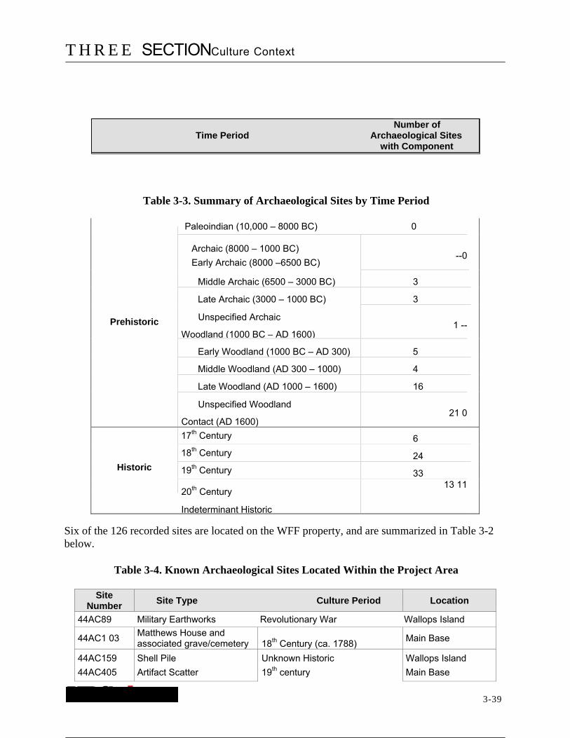
T H R E E SECTIONCulture Context
3-39
Table 3-3. Summary of Archaeological Sites by Time Period
Paleoindian (10,000 – 8000 BC) 0
Archaic (8000 – 1000 BC)
Early Archaic (8000 –6500 BC) --0
Middle Archaic (6500 – 3000 BC) 3 Late Archaic (3000 – 1000 BC) 3
Prehistoric Unspecified Archaic
Woodland (1000 BC – AD 1600)1 --
Early Woodland (1000 BC – AD 300) 5
Middle Woodland (AD 300 – 1000) 4 Late Woodland (AD 1000 – 1600) 16 Unspecified Woodland
Contact (AD 1600)21 0
17th Century 6 18th Century 24
Historic 19th Century 33
20th Century
Indeterminant Historic
13 11
Six of the 126 recorded sites are located on the WFF property, and are summarized in Table 3-2 below.
Table 3-4. Known Archaeological Sites Located Within the Project Area
Site Number
Site Type Culture Period Location
44AC89 Military Earthworks Revolutionary War Wallops Island
44AC1 03 Matthews House and associated grave/cemetery 18th Century (ca. 1788)
Main Base
44AC159
44AC405
Shell Pile
Artifact Scatter
Unknown Historic
19th century
Wallops Island
Main Base
Number of Time Period Archaeological Sites
with Component

T H R E E SECTIONCulture Context
3-40
44AC437 Artifact Scatter 18th and 19th centuries Main Base
No number Temporary Camp Possible Middle Archaic,
Woodland, possible Historic Mainland

T H R E E SECTIONCulture Context
3-41
The un-numbered site listed in Table 3-4 is a prehistoric site partially excavated by the Eastern Shore Archaeological Society in 1996 (Greenley 1997). The group recovered one broken projectile point, and an unspecified number of chert and quartz debitage, possible ceramics, and animal bone. In addition, brick was recovered during the excavations. The one-paragraph site report that was prepared indicates the projectile point resembled a Morrow Mountain point that dates to the Middle Archaic Period. The presence of possible prehistoric ceramics also indicates a Woodland Period component to the site. A site number was apparently never issued, and the current disposition of the artifacts is unknown; they may be held by the WFF Office of Public Affairs.
3.3.2 Historic Structures
Twenty-nine historic properties have been identified within a 3-km (2-mile) radius of the project area (Appendix C). Many of these are associated with archaeological sites. A summary of the number of historic properties by time period is in Table 3-5. Note that as with the archaeological sites in Table 3-3, the table below identifies the number of components per time period (e.g., 20th century), and that a resource can have more than one component. Two historic properties within the project area have been assigned DHR Inventory Numbers. The entire WFF (DHR ID# 001-0027), although inventoried as an historic property, has not been evaluated for eligibility to the NRHP. The Matthews House (DHR ID# 01-0155), is a ca. 1788 house site located in the southeastern portion of the Main Base. This resource also has an archaeological site number (44AC103). The house was removed in the 1950s during expansion of the runway.
Table 3-5. Summary of Historic Properties by Time Period
Time Period Number of
Resource Type Resources with
17th Century n/a 0
18th Century Dwelling
Dwelling
3
19th Century 7
20th Century
Dwelling 14
Bridge 3
Wallops Station
Indeterminant
1
Indeterminant 2

F OUR SECTIONResearch Design
4-42
4.0 RESEARCH DESIGN
4.1 OBJECTIVES
The primary goal of the sensitivity assessment of the WFF was to facilitate the long-term management of historic properties (both archaeological and architectural) within the project area by NASA. Archaeology-specific goals include the development of a predictive model for historic and prehistoric archaeological site location, assessment of the condition of existing archaeological sites within the project area, and recommendations for protection of known, and yet to be identified, archaeological resources on the WFF property.
The goal of the historic structures component of the study was to gather base-line information regarding all buildings, structures, and facilities on the WFF property in order to record a general impression of the type and integrity of potential historic properties at the facility. This information will be used to generate recommendations for additional historic standing structure identification, National Register evaluation, historic context development, and other preservation planning activities at WFF.
4.2 METHODS
4.2.1 Background Research
Background research was conducted at the Virginia DHR. Site files and cultural resources management reports were examined at DHR, information was gathered on historic properties and archaeological sites in the area, and other relevant data specific to the project area were collected. Relevant historic documents, including maps and published histories, were examined. Other sources examined include published archaeological studies relevant to the region. The WFF supplied background materials, including copies of previous studies conducted on the WFF property, as well as a series of historic engineering maps identifying structures on the Wallops Main Base and the different periods of the base’s development.
The DHR’s inventory of historic properties and the NRHP files were examined to determine if any historic properties at the WFF were represented. The latter program, administered by the National Park Service, recognizes a range of historic property types that are significant in American history and culture and are worthy of consideration for preservation. This research produced two findings: 1) no historic standing structures have been incorporated into the state’s historic buildings inventory, and 2) no historic standing structures on the WFF are currently represented in the National Register of Historic Places. In addition, National Historic Landmark (NHL) program files were examined to determine if any historic properties at the WFF were represented. This effort verified that no historic property at the WFF is currently included in the NHL NASA theme study.
Readily-available secondary sources were used for the historic structures survey. This included the previous cultural resources assessment document prepared for the WFF (Miller 1991). Also used was NASA Reference Publication 1028. This 1978 publication, authored by Joseph

F OUR SECTIONResearch Design
4-43
Shortal, A New Dimension – Wallops Island Flight Test Range: The First Fifteen Years, chronicles the development of the WFF facility by the NACA. The windshield survey was guided by three maps provided by WFF, including a series of historical maps of the facility dating from 1942-1957. Specifically, these included:
� General Plot Plan – Auxiliary Air Station, Chincoteague, Virginia by Giffels and Valet, Engineers and Architects, Detroit, Michigan, dated October 1942. Drawing number 221,423.
� Map of Navy Auxiliary Air Station and Naval Ordnance Test Station, Chincoteague, Virginia by U.S. Navy, dated 1950. Drawing number 24970. Depicts facility conditions as of June 1950.
� General Development Plan – Naval Air Station, Naval Ordnance Test Station, Chincoteague, Virginia by U.S. Navy, dated 1957. Drawing #34490. Depicts conditions as of December 31, 1957.
A 1996 map of all WFF facilities with identification numbers was also examined. This corresponds to information included in the real property list included as Appendix B to the 3D/Environmental Services cultural resources assessment (Miller 1991).
4.2.2 Archaeology Methods and Expected Results
The archaeological predictive model was developed using data gathered from existing studies and site forms reviewed at the DHR, data provided by the WFF, and from windshield and pedestrian reconnaissance. Mapping data, made available by the WFF, was used to determine areas of disturbance, wetlands, as well as to provide topographic data. These data were applied to WFF in order to determine areas of low, moderate, and high sensitivity. The data were used to generate maps to be used for planning purposes.
Expectations about potential archaeological site location and distribution across the WFF are based on the analysis of existing archaeological data for the Atlantic Coastal Plain (and especially the Delmarva Peninsula), as well as the environmental setting of the WFF. As shown in Table 3-2, six archaeological sites are located on the WFF, and include one prehistoric and five historic sites. The prehistoric site dates to at least the Middle Archaic Period (6500 – 3000 BC) and the historic sites date from the mid- to late 18th century through the 20th century. One of the historic sites (a shell pile) is of unknown age.
The Wallops Main Base and Mainland are located on stable landforms adjacent to tidal marshes. Prehistoric sites dating from the Archaic through Woodland Periods can be expected along the fringes of these areas that border waterways (e.g., creeks, tidal marsh, bay, ocean). Historic sites, dating from the 18th through the 20th century, also can be expected along the fringes of waterways as well as on high ground further away from water. Prehistoric and early historic sites may be located in tidal marshes, especially on landforms that have been inundated due to Holocene sea-level rise. Wallops Island, although now extensively disturbed by modern human activities, may contain prehistoric and historic resources. Prehistoric sites dating to the Late Woodland Period, and possibly the late Middle Woodland Period are expected on the back barrier dune environment on the island (Lowery 2003, personal communication). No sites dating

F OUR SECTIONResearch Design
4-44
to the Archaic or Paleoindian Periods are expected on Wallops Island. Instead, sites dating to these time periods are probably located offshore to the east in areas of formerly dry land. Historic sites are expected on Wallops Island. One documented historic structure is located on Wallops Island (the 1936 U.S. Coast Guard Station), as well as a Revolutionary War earthworks (site 44AC89) and one historic shell midden (44AC159). It must be stressed that due to the extensive earth-moving and construction activities that occurred on the WFF property since the 1940s, that the overall expectation of intact archaeological resources is relatively low.
4.2.3 Historic Structures Survey Methods and Expected Results
All survey work undertaken in the state of Virginia is conducted using the DHR Guidelines for Conducting Cultural Resource Survey in Virginia (2003). This document outlines the steps that should be used in detailed architectural survey work, including the use of historic contexts. Designed as an analytical tool by the National Park Service in the Secretary of the Interior’s Standards and Guidelines for Historic Preservation Planning, a historic context organizes information based on a historical/cultural theme and its geographical and chronological limits. The use of one or more historic contexts assists the user in evaluating the relative importance and significance of surveyed properties.
Based on the background research, it was anticipated that historic standing structures at the WFF would fall into two of the standard periods identified by DHR. These are:
� World War I to World War I (1917 – 1945) and � The New Dominion (1945 – Present)
4.2.3.1 Windshield Survey
The windshield survey was conducted on August 12, 2003. URS Architectural Historian Mark Edwards, accompanied by EG&G Environmental Scientist Shari Silbert, viewed all buildings, structures and facilities on the Main Base and Island portions of the WFF. Field notes and digital photographs were taken of representative buildings throughout all sections of WFF (Appendix D).
The windshield survey was conducted in order to gather data that were used to select a limited number of buildings, structures and facilities to document in the reconnaissance-level component of the project. Properties identified in the windshield survey are often well-preserved or least-altered examples of certain resource types. This windshield survey was also undertaken to obtain a general idea about the number of pre-1955 properties extant at the WFF. This date represents the “50 year cut-off” date that is generally used in evaluation of properties for listing in the National Register of Historic Places. This evaluation, which will occur in future phases of the project, would be an essential ingredient in the development of a facility-wide Integrated Cultural Resource Management Plan (ICRMP), the recommended management tool used by federal agencies and facilities to meet their Section 110 responsibilities of the National Historic Preservation Act of 1966. (A copy of the National Park Service’s Section 110 guidelines is included as Appendix F.

F OUR SECTIONResearch Design
4-45
As part of the windshield survey, the locations of all properties examined were noted on the two facility maps for the WFF. These maps were then used for the site locations for the six buildings and structures surveyed at the reconnaissance level.
4.2.3.2 Reconnaissance-Level Survey
Based on the results of the windshield survey of the WFF, a more detailed examination of six properties was conducted. In addition to the Navy Family Housing that received detailed examination, two other variations of Navy Family Housing were identified during the windshield survey. Survey field notes and 35mm black and white photographs were taken of these housing variants. This ensured that the range of all historic property types associated with Navy Family Housing will be available as part of future historic preservation compliance review by DHR of WFF projects and related undertakings.
The reconnaissance level documentation process began during a field visit on August 29, 2003. The data recorded for each property was guided by the requirements of the DHR reconnaissance level documentation form. Information gathered for these properties included location, building descriptions, approximate dates of construction and any alteration, and data on important landscape attributes. A detailed physical description of the primary resource was gathered during this phase of the survey. A field form also included a site plan, identification of the photographs associated with the property, and a notation of the building’s condition and any known threat to the building. The field forms included a place to record any additional information about the property collected during the site visit. Examples of additional information include such things as owner’s names, oral history of the property, and recommendations for further research.
Exterior black and white 35mm photographs accompany each selected property. Generally, the photographs included views of both façades. A site plan was sketched at each property to illustrate the relationship of the building to nearby features. Significant features such as ponds, creeks, or tree lines were noted on the site plans. Each of the properties surveyed has been plotted on both the WFF facility map and the appropriate USGS 7.5 minute quadrangle map.
Properties were selected for inclusion in this effort based on their representative character and age, and on the basis of scheduled facility modernization and/or demolition plans which could affect the properties. Properties scheduled for renovation and/or demolition within the next two years were given priority. These properties included the Old Coast Guard Station (WFF ID# V - 65) and one example of Navy Family Housing (WFF ID# H-015).

FIVE SECTIONResults of Archaeological Sensitivity Assessment
5-46
5.0 RESULTS OF ARCHAEOLOGICAL SENSITIVITY ASSESSMENT
5.1 PREDICTIVE MODEL
Assessment of the project area for archaeological sensitivity involved the examination of topographic maps, historic documents and maps, and DHR files containing site location data. In addition, predictive models developed for the area (e.g., Fehr et al. 1988; Lowery 2003; Miller 1991) were reviewed, evaluated, and adapted for the project area. Separate predictive models for prehistoric and historic archaeological site location in the project area have been developed and are discussed below.
5.1.1 Prehistoric Site Predictive Model
Miller (1991) proposed a predictive model for the WFF using generalized models of prehistoric settlement for mainland areas. That model could be improved as it lacked an explicit statement about the criteria used to develop the model, and lacked any mapping to show areas of low, moderate, or high archaeological potential. Fehr et al. (1988) developed a model for Assateague Island that predicted site locations based on the relative ages of the landforms on the island. Due to the relatively young age of the Assateague Island deposits and active reworking by wind and water, Fehr et al. (1988) predicted virtually no prehistoric resources on the island. Their model considered dry land areas only, and did not consider potential for buried or submerged archaeological deposits. While useful for a particular project area (i.e., a wave-dominated barrier island environment), the Fehr et al. (1988) model is not directly applicable to the WFF project area.
Lowery (2003) has developed a detailed settlement model for prehistoric sites on the Delmarva Peninsula. His consideration of climate change, geology, sea level rise, as well as other factors has led to a more accurate model for predicting prehistoric site locations in the Delmarva Peninsula. Archaeological research throughout eastern North America has demonstrated that prehistoric peoples generally favored topographically high, well-drained areas located near water sources for occupation. Taking these factors into consideration, Lowery (2003:123) used four main criteria for predicting prehistoric site locations:
1. Soil Type – well-drained versus poorly-drained soils; 2. Slope – fairly level (between 2 and 10 percent) versus steep (over 10 percent); 3. Water Source – streams, springs, wetlands, marshes, coves, or bays; and 4. Water Type – freshwater, brackish, or saltwater.
Lowery (2003) defined 10 archaeological site location types for the Delmarva Peninsula based on the four main criteria, as well as factoring in ecological diversity of the area (the more ecologically diverse, the more likely to contain prehistoric sites), Holocene landscape changes, and recorded site locations. The 10 site location types are distributed between the broader categories of interior versus coastal settlement locations (Table 5-1).
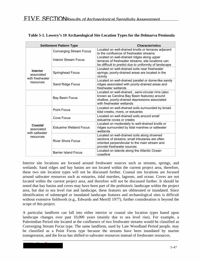
FIVE SECTIONResults of Archaeological Sensitivity Assessment
5-47
Table 5-1. Lowery’s 10 Archaeological Site Location Types for the Delmarva Peninsula
Settlement Pattern Type Characteristics
Interior associated
with freshwater resources
Converging Stream Focus
Interior Stream Focus
Located on well-drained knolls or terraces adjacent to the confluence of freshwater streams Located on well-drained ridges along upper terraces of freshwater streams; site locations can be difficult to predict due to uniformity of landscape
Springhead Focus Located on well-drained soils near freshwater springs; poorly-drained areas are located in the vicinity
Sand Ridge Focus Located on well-drained parallel or dome-like sandy ridges associated with poorly-drained areas and freshwater wetlands
Bay Basin Focus
Located on well-drained , semi-circular rims (also known as Carolina Bay Basin features) around shallow, poorly-drained depressions associated with freshwater wetlands
Coastal associated
with saltwater resources
Point Focus Located on well-drained soils surrounded by broad tidal creeks, rivers, or estuaries
Cove Focus Located on well-drained soils around small estuarine coves or creeks
Estuarine Wetland Focus Located on moderately to well-drained knolls or ridges surrounded by tidal marshes or saltwater wetlands
River Shore Focus
Located on well-drained soils along drowned sections of streams; small tributaries are often oriented perpendicular to the main stream and provide freshwater sources
Barrier Island Focus Located on islands along the Atlantic Ocean coastline
Interior site locations are focused around freshwater sources such as streams, springs, and wetlands. Sand ridges and bay basins are not located within the current project area, therefore, these two site location types will not be discussed further. Coastal site locations are focused around saltwater resources such as estuaries, tidal marshes, lagoons, and ocean. Coves are not located within the current project area, and therefore will not be discussed further. It should be noted that bay basins and coves may have been part of the prehistoric landscape within the project area, but due to sea level rise and landscape, these features are obliterated or inundated. Since identification of submerged or inundated landscape features and archaeological sites is difficult without extensive fieldwork (e.g., Edwards and Merrill 1977), further consideration is beyond the scope of this project.
A particular landform can fall into either interior or coastal site location types based upon landscape changes over past 10,000 years (mainly due to sea level rise). For example, a Paleoindian Period site located at the confluence of two freshwater streams would be classified as Converging Stream Focus type. The same landform, used by Late Woodland Period people, may be classified as a Point Focus type because the streams have been inundated by marine transgression, and the focus has shifted to saltwater resources instead of freshwater resources.

FIVE SECTIONResults of Archaeological Sensitivity Assessment
5-48
Lowery’s (2003) predictive model for prehistoric site locations on the Delmarva Peninsula was tailored to the current project area. Additional criteria were used in assessing the prehistoric archaeological sensitivity of the WFF, and include:
1. Existing location data for prehistoric archaeological sites within a five-mile radius of the project area;
2. Ground disturbance – used to determine which areas contain extensive disturbance from modern activities, and are therefore unlikely to contain intact, undisturbed archaeological deposits; and
3. Distance to water – a secondary criterion for the current project area since both freshwater and saltwater are close (generally less than 160 meters or 500 feet away).
The above model describes areas of moderate and high sensitivity for prehistoric archaeological resources. Low archaeological sensitivity areas include any of the following characteristics: poorly-drained soils (during prehistory); slopes greater than 10 percent; distances greater than 160 meters (500 feet) from water; and severe disturbance from modern activities, such as construction and earth-moving. The predictive model for prehistoric site locations within the current project area is summarized in Table 5-2.
Table 5-2. Prehistoric Site Predictive Model for the Project Area
Sensitivity Landform Soil Drainage Type Slope Distance
to
Low
tidal marsh, topographically low areas poorly-drained
< 2 % n/a
terrace, knoll, ridge, and bluff edges
terrace, knoll, ridge, bluff
all types
all types
> 10 %
n/a
n/a
> 160 meters (> 500 feet)
Moderate terrace, knoll, ridge, bluff, barrier island
moderately-drained 2 – 10 % < 160 meters (< 500 feet)
High
terrace, knoll, ridge, bluff, barrier island
well-drained 2 – 10 % < 160 meters (< 500 feet)
hummock or knoll in tidal marsh
moderately- to well-drained
2 – 10 % n/a
5.1.2 Historic Site Predictive Model
No predictive models have been developed for historic period sites on the Virginia Eastern Shore. Historic settlement patterns generally are more complex (i.e., having more distinct settlement types) than settlement patterns for the prehistoric period. In addition, historic sites tend to occur in a wider variety of settings than prehistoric sites. Thus, predictive models that apply to all types of historic sites are typically ineffective.
The following general statements can be made concerning historic site locations on the Virginia Eastern Shore. Domestic sites tend to be located in the same types of settings (i.e., topographically elevated, well-drained, relatively level terrain) as prehistoric sites. On the

FIVE SECTIONResults of Archaeological Sensitivity Assessment
5-49
Eastern Shore, where waterways are important to the early historic subsistence and economic bases of society, domestic, municipal, industrial, and commercial sites are located close to navigable water. As populations grew and infrastructures improved, proximity to navigable water, while still important, became less critical, and people dispersed across the landscape. By the 19th century, the interior areas of the Eastern Shore were populated. It should be noted that the Virginia Eastern Shore mainland is approximately 10 miles across at its widest point, so settlements, in any case, were never very far from navigable water. Nonetheless, early historic settlements tended to be clustered along the shorelines, while later historic settlements tended to be dispersed across the landscape.
Smolek (1984) has noted that 17th century settlements on the Western Shore of Virginia and Maryland tended to be located within 180 meters (600 feet) of navigable water. Smolek (1984) also noted a difference between Virginia and Maryland settlement patterns where Virginia settlements were located across the landscape and tended to rely on wells for water, while Maryland settlements were concentrated around freshwater springs. Virginia Eastern Shore settlement patterns during the 17th century were probably similar to Virginia Western Shore settlement patterns, though it can be expected that a variety of freshwater sources were used. Distance to freshwater resources does not appear to be an important criterion for predicting historic site location on the Virginia Eastern Shore since freshwater streams and springs were ubiquitous in the area during the early historic period (17th and 18th centuries).
In theory, the shift in settlement patterns from the 17th through the 19th centuries should be visible in the archaeological landscape. In practice, however, 17th and early 18th century sites generally tend to have low archaeological visibility, while mid 18th century through 19th century sites tend to have greater archaeological visibility. On the Virginia Western Shore, 17th century settlements tend to be fortified, and therefore have greater archaeological visibility than Eastern Shore settlements, which were not fortified during the 17th century. Many factors have affected the preservation of 17th and early 18th century settlements on the Virginia Eastern Shore, including, but not limited to: lower populations, and therefore fewer sites than the mid-18th through 19th centuries; the impermanent nature of dwellings when the area was first settled (e.g., no brick foundations); “modernization” of structures over time, so that early structures were renovated or torn down and replaced with contemporary structures; and repeated use of the same locations over a few centuries, where earlier features (e.g., foundations, trash middens) may have been obscured by later occupations.
Recent historic predictive models developed for the Virginia interior Coastal Plain (e.g., Jones et al. 1997; Linebaugh and Blanton 1996) are summarized in Table 5-3.
Table 5-3. Historic Site Predictive Model for the Virginia Interior Coastal Plain
Sensitivity Landform Slope Distance to Water
Low Any > 20 % n/a
Moderate Ridges 10 – 20 % n/a
High Stream terraces, floodplains, ridges 0 – 10 % < 300 meters (900 feet)

FIVE SECTIONResults of Archaeological Sensitivity Assessment
5-50
Linebaugh and Blanton (1996) acknowledge that three historic site types do not fit the general historic predictive model: military sites, mill sites, and cemeteries. Military sites, such as Revolutionary War and Civil War sites, are typically situated according to tactical considerations (e.g., troop movements, defense) “rather than the generally accepted criteria for domestic site location such as soils, slope, and distance to water” (Linebaugh and Blanton 1996:28). Mill sites, which do not become prevalent until the 19th century, also diverge from the criteria for domestic site locations. Mill sites tend to be adjacent to primary tributaries in areas unsuitable for habitation (Linebaugh and Blanton 1996:28). Cemeteries, though fitting within the criteria for domestic site location, may be found on any relatively flat landform, and therefore may occur in areas otherwise unsuitable for occupation. Cemeteries located in rural areas can be small and contain unmarked graves or small, unmarked headstones.
The model presented in Table 5-3 is relevant for predicting historic domestic, cemetery, and non-maritime-focused (e.g., agricultural, commercial, government, industrial, religious) site locations on the Virginia Eastern Shore. The model does not, however, effectively predict the locations of other site types, such as municipal, commercial, or industrial sites, especially commercial and industrial activities focused around maritime resources. In an attempt to develop an historic site predictive model relevant to the Virginia Eastern Shore and the current project area, the following criteria were considered:
1. For domestic sites, cemeteries, and non-maritime commercial and industrial sites, the following ranking criteria were considered:
a. Soil type – poorly-drained versus well-drained soils; b. Landform – e.g., steep banks may have high sensitivity for sites such as mills, while
topographically elevated areas may contain dwellings or cemeteries; c. Slope – level versus steep; d. Distance to water; e. Existing location data for historic archaeological sites within a five-mile radius of the
project area; f. Locations of standing structures, ruins, and cemeteries – highly visible clues to the
presence of probable historic sites; and g. Degree of ground disturbance – used to determine which areas contain extensive
disturbance from modern activities, and are therefore unlikely to contain intact, undisturbed archaeological deposits.
2. For maritime-focused sites, the following criteria were considered: a. Distance to water – for maritime-oriented sites, distance to saltwater is 0; b. Existing location data for maritime-focused historic archaeological sites within a five-
mile radius of the project area; c. Locations of standing structures and ruins – highly visible clues to the presence of
probable historic sites; and d. Degree of ground disturbance – used to determine which areas contain extensive
disturbance from modern activities, and are therefore unlikely to contain intact, undisturbed archaeological deposits.

FIVE SECTIONResults of Archaeological Sensitivity Assessment
5-51
The predictive models for historic site locations within the current project area are summarized in Tables 5-4 and 5-5.
Table 5-4. Non-Maritime Historic Site Predictive Model for the Project Area
Sensitivity Landform Soil Drainage Type Slope Distance to
F h t
Low tidal marsh poorly-drained < 2 % 0
terrace or bluff edge all types > 20 % > 15 meters (> 50 feet)
Moderate terrace, ridge, knoll moderately to well-drained
10 – 20 % n/a
High (all site types terrace, ridge, knoll except mills)
well-drained
n/a
2 – 10 % < 300 meters (< 900 feet)
terrace or bluff edge High adjacent to freshwater (mills only) source
> 20 % 0
Domestic sites and cemeteries, as well as commercial and industrial sites such as taverns, tanneries, and mills, are included in the non-maritime sites. Low archaeological sensitivity areas include severe disturbance from modern activities, such as construction and earth-moving.
Table 5-5. Maritime Historic Site Predictive Model for the Project Area
n/a > 30 meters(> 100 feet)
n/a n/a
> 2 % and < 10 %
< (<
30 meters100 feet)
n/a < (<
30 meters100 feet)
Note: Maritime sites include domestic sites such as fishing village communities
Maritime site types include commercial (e.g., fish oil processing plants), industrial (e.g., saltworks), and transportation (sailing vessels), as well as fishing communities that may contain dwellings but have a strong maritime focus. Mainland sites located over 30 meters (100 feet) from the shoreline are not considered maritime focused, however, barrier island sites, whether dwellings, commercial, or industrial, are considered maritime focused. Low archaeological sensitivity areas include severe disturbance from modern activities, such as construction and earth-moving.
Sensitivity Landform
Low terrace all types
shoreline, tidal marsh, barrier island
poorly to moderately-drained
Moderate
High (domestic*) barrier island well-drained
High (other barrier island, beach than domestic) shoreline, tidal marsh
poorly to well-drained

FIVE SECTIONResults of Archaeological Sensitivity Assessment
5-52
5.2 SENSITIVITY ASSESSMENT
Using the models developed for prehistoric and historic archaeological site location, areas of low, moderate, and high archaeological sensitivity were identified. The sensitivity model predicts the locations of archaeological sites, but not the temporal association (e.g., Paleoindian or 17th century). The results of this analysis are presented below. The discussion is divided by the three areas of the WFF: Wallops Main Base, Wallops Mainland, and Wallops Island.
5.2.1 Wallops Main Base
The Main Base landscape has been altered substantially since the 1940s when the Chincoteague Naval Air Station was established. NASA’s occupation of the property led to more extensive changes as episodes of construction and removal were completed in keeping with innovations and developments in the aeronautics and space industry. The result of these modifications is that most of the soil deposits on the Main Base are disturbed, and therefore contain low sensitivity for prehistoric and historic resources. Figures 13 through 15 illustrate the changes to the Main Base from 1942 to 1957, and Table 5-6 shows changes in the numbers of structures during this period to illustrate the extensive changes to the Main Base.
Table 5-6. Changes in Number of Structures
Year Number of Structures
1942 < 175
1950 402
1957 340
5.2.1.1 Prehistoric Archaeological Sensitivity
No prehistoric archaeological sites have been identified on the Main Base. Some portions of the Main Base, however, appear to have experienced little or no ground disturbance. Figure 16 shows areas of low, moderate, and high sensitivity for prehistoric archaeological resources. The northern and northwestern portion of the Main Base borders Little Mosquito Creek and Wattsville Branch. These areas contain well-drained terraces and ridges with 2 to 10 percent slopes, and are less than 160 meters (less than 500 feet) from water. These areas have high sensitivity for prehistoric archaeological resources (Figure 16); portions of these areas, however, are disturbed from construction activities (e.g., structures, runway, roads, and sand pits) and are considered to have low to moderate sensitivity for prehistoric archaeological resources.
The northeastern portion of the Main Base (in the area of the Wallops Visitors Center) fits the criteria for moderate sensitivity for prehistoric resources due to construction disturbances from roadways (e.g., Route 175) and the Visitors Center (Figure 16). The southeastern portion of the Main Base contains areas that fit the criteria for moderate and high sensitivity for prehistoric archaeological resources (Figure 16). Moderate sensitivity areas are those areas that have been

FIVE SECTIONResults of Archaeological Sensitivity Assessment
5-53
disturbed through construction activities. The remaining portions of the Main Base, as mentioned above, have been substantially altered, and are considered to have low sensitivity for prehistoric archaeological resources.
5.2.1.2 Historic Archaeological Sensitivity
One late 18th century domestic site and associated grave/cemetery (site 44AC 103) has been identified previously in the southeastern portion of the WFF (Figure 17). Site 44AC 103, the Matthews House, is a late 18th century domestic site and associated grave/cemetery that was disturbed by the US Navy in the 1 950s during construction of the runway in the southeastern portion of the project area. Although the house has been removed, there may be intact or undisturbed archaeological deposits related to the house. The site is currently not in danger of further disturbance.
A 19th century historic artifact scatter (44AC405) has been identified in the southwestern part of the Main Base (Figure 17). This artifact scatter may be associated with site 44AC 103, as this was probably a farmstead during the late 18th and 19th centuries, and trash dumping in agricultural fields during these periods has been well-documented in the archaeological record. An 18th through 19th century artifact scatter (44AC437) has been identified in the northwestern portion of the project area, on the small parcel across Wattsville Branch from the Main Base (Figure 17). This area was previously surveyed by Otter (1991), and has extensive disturbance from sand quarrying activities that occurred prior to ownership of the land by NASA. No other archaeological sites have been identified on the Main Base.
Documentary evidence indicates that a Revolutionary War fort was located at Mosquito Point, along Mosquito Creek (Krieger 1976). Anecdotal evidence suggests that this fort may have been located in the northeastern corner of the Main Base, on the high bluff overlooking Little Mosquito Creek, as it would have been an excellent vantage point across Chincoteague Bay. This area currently contains an access roadway to the NOAA facility, and also contains the northern terminus of the Wallops airstrip. The USGS topographic map locates Mosquito Point in the marsh on Chincoteague Bay northeast of the Main Base. If the fort was located on the bluff on the Main Base, evidence of it may have been destroyed during construction of the airstrip and access roads. If the fort was, in fact, located on Mosquito Point on Chincoteague Bay, then it is outside of the project area.
The terraces and knolls along the northern portion of the Main Base fit the criteria for moderate sensitivity for historic non-maritime archaeological sites, due for the most part to the construction activities that have occurred in this area (Figure 17). Any standing structures would have been removed in order to construct the various facilities (e.g., munitions bunkers, water treatment plant), but subsurface deposits may have remained intact in areas of lesser disturbance. There are not likely to be any mills along this portion of the Main Base; Whitelaw (2001) indicates a mill in operation as early as the mid-17th century was located where Wallops Pond drains into Wattsville Branch (to the immediate west of the project area). Period documents indicate no more than one mill was constructed on a tributary (Turman 1964). Additional mills, therefore, would not have been constructed downstream from the Wallops Pond mill. The areas of tidal marsh and shoreline in this area have moderate to high sensitivity for historic maritime

FIVE SECTIONResults of Archaeological Sensitivity Assessment
5-54
archaeological sites. The terraces and knolls on the east side of Wattsville Branch have moderate to high sensitivity for historic non-maritime archaeological sites, and the west side of Wattsville Branch has low sensitivity due to the sand quarrying operations.
The northeastern and southeastern portions of the Main Base, exclusive of areas where known archaeological sites are located (i.e., 44AC 103), fit the criteria for moderate to high sensitivity for non-maritime historic archaeological sites (Figure 17). The terraces are moderately to well-drained and have 2 – 20 percent slopes. The southeastern area is greater than 30 meters (greater than 100 feet) from the tidal marsh and saltwater, and therefore has low sensitivity for historic maritime archaeological sites. The northeastern portion of the Main Base, in the vicinity of the Wallops Visitors Center, is close to the tidal marshes and therefore has high sensitivity for historic maritime archaeological sites.
The remaining portions of the Main Base are considered to have low sensitivity for historic archaeological resources due to the substantial alterations to the landscape throughout the 20th century. Many of the 20th century structures on the property may meet the 50-year criteria for historic properties (as discussed in the next chapter). The archaeological potential of areas that contain scientific research and administrative structures is low due to the nature of the use of the facilities (i.e., people were not living there). The archaeological sensitivity of areas of the Main Base used for housing is moderate to high, and several research questions could be developed to address these deposits, such as the nature of military versus civilian material culture during World War II. The housing areas on the Main Base, however, are unlikely to yield information important to our understanding of World War II, or post-World War II. One reason for this is because trash disposal patterns during the mid-20th century were different from earlier periods, where trash (such as food remains and broken dishes) was thrown behind the kitchen or spread as a manuring practice in agricultural fields. Mid-20th century trash disposal practices were different, and trash on the base was undoubtedly collected and taken to a dump or incinerated. Thus, fewer material culture remains (e.g., ceramics, food refuse, glass, and personal items) would have been deposited for archaeologists to study decades later.
Another reason for the lack of important information is that since the housing in this part of the Main Base was still in use well into the late 20th century (and some is still in use today) any yard deposits would be mixed (i.e., not likely stratified), and the context for any World War II-era deposits would be disturbed and difficult to separate from later periods of occupation. Any artifacts diagnostic of the period would be mixed with artifacts from over 50 years, and sorting out the different occupations would be extremely difficult.
In summary, while many of the structures on the Main Base may be significant because of architectural or engineering styles unique to the period, archaeological deposits are unlikely to yield important information concerning early use of the property by the military or by NASA.
5.2.2 Wallops Mainland
The Mainland has not undergone the changes that the Main Base has over the years. One prehistoric site is located on the Wallops Mainland (Figure 18). This site, dating from the Archaic (8000 – 1000 BC) through Woodland (1000 BC – AD 1600) Periods, was partially

FIVE SECTIONResults of Archaeological Sensitivity Assessment
5-55
excavated by the Eastern Shore Archaeological Society, an avocational group, in 1996. The current disposition of the artifacts recovered during this excavation is unknown.
Portions of the Mainland fit the criteria for high sensitivity for prehistoric archaeological sites (Figure 18). These areas are located on the well-drained low terraces adjacent to Hog Creek and tidal marsh. The archaeological site discussed above, is located on one of these terraces. The remainder of the area contains poorly-drained soils, steep slopes (greater than 10 percent), or disturbance from construction. These areas are considered to have low sensitivity for prehistoric archaeological resources.
The Mainland area fits the criteria for high sensitivity for historic non-maritime and maritime archaeological sites (Figure 19). The area contains a range of landform, soil drainage types, and slopes that would have been suitable for a variety of activities. Additionally, the Mainland is located adjacent to Hogs Creek and tidal marsh, which was suitable for maritime activities such as fishing camps and saltworks.
5.2.3 Wallops Island
The tidal marshes between the Mainland and Wallops Island were not assessed for archaeological sensitivity. These areas probably contain prehistoric archaeological resources that are buried under peat and organic deposits. It is difficult to predict the locations of sites without extensive geological analysis to determine, for example, the locations of inundated creek channels, or what the pre-inundation topography was like. Lowery (2003) has documented the accretionary nature of the Atlantic tidal marshes; in other words, sediment is deposited faster than it erodes, and therefore any prehistoric archaeological sites are possibly well-protected from erosion. Nonetheless, any dredging or other activities planned for tidal marsh areas should be assessed for prehistoric archaeological potential.
Wallops Island has been developed since 1945, and portions of the Island have been extensively modified to accommodate the research facilities. The seawall, constructed on the seaside of the island, has slowed down erosion and possibly has served to preserve potential archaeological sites.
Two archaeological sites have been documented on the island (Figures 20 and 21). The Revolutionary War earthworks, site 44AC89, is located on the northern end of the island. Site 44AC159 is a three-foot high shell pile located on the southern end of the island. The site probably dates to the 20th century, although the exact nature and origin of the shell pile is unknown. The site was recorded, but not investigated, in 1980. It is not known if the site still exists, as Lowery (2003) did not report it in his shoreline survey.
Portions of Wallops Island fit the criteria for moderate to high sensitivity for prehistoric archaeological sites (Figures 20 and 21). These areas are located on the lagoon-side of the island. Soils in these areas are well-drained with 2 – 10 percent slopes, and are less than 160 meters (less than 500 feet) from water. Areas considered to have moderate sensitivity are located around areas of construction. The remaining areas are considered to have low sensitivity for
FIVE SECTIONResults of Archaeological Sensitivity Assessment
5-56
prehistoric archaeological resources due to poorly-drained soils, less than 2 percent slopes, or areas of extensive disturbance from development.
Wallops Island was used for livestock grazing from the mid-17th through 19th centuries. There is documentation for historic occupation of the island during this period, other than impermanent structures associated with tenders of livestock or with the Revolutionary War fort at Gunboat point. It is possible that the impermanent nature of the structures and Atlantic storms have resulted in little to no preservation of early historic remains on the island. Wooded areas may have remained protected and may contain historic archaeological resources. The northern portion of the island is considered to have high potential for historic maritime archaeological resources, especially those related to the Revolutionary War fort on the island (Figure 22). The extreme northeastern end of the island is considered to have low sensitivity for archaeological resources, due to the building out of this landform during the 20th century. Figures 23 through 28 show the changes at this end of the island during the 20th century, and identifies the reported location of the Revolutionary War earthworks (site 44AC89).
Other areas of the island are considered to have moderate to high sensitivity for historic archaeological resources (Figure 29). Given the barrier island setting and proximity to a diverse ecological setting, as well as documented use of the island (i.e., as grazing land for livestock) more of the land area would have been used during the historic period. Maritime activities, such as saltworks, fish, or shellfish processing sites may be located on the island. Areas of development on the island are considered to have low sensitivity for historic archaeological resources.
The US Coast Guard Station structure, located on the lagoon side of the island, dates to 1936 (Figure 22). The earlier 19th century Life-Saving Station was located on the Atlantic side of the island, and not where the 1936 structure is located. The structure has been used throughout the late 20th century for a variety of purposes. There may be limited archaeological deposits associated with this structure that date to the Coast Guard occupation of the site. With use and modification of the area throughout the 20th century, any early archaeological deposits have likely been mixed with later occupations, and therefore would yield no information important to the 193 0s occupation of the site.

SIX SECTIONResults of Historic Structures Assessment
57-
6.0 RESULTS OF HISTORIC STRUCTURES ASSESSMENT
Both the windshield survey and reconnaissance-level survey process provided an illustration of the development of the WFF facility, from its first years through the present day. The WFF is a dynamic facility that continues to fulfill its primary scientific and research missions through the remodeling and re-use of older buildings and structures, as well as the construction of new buildings and structures when needed. These interrelated missions have resulted in the continued use of many buildings, structures and facilities built in the first period of the facility’s history, from 1945 to 1950. As the WFF grew and its mission expanded, additional scientific testing structures and facilities were built, especially through the second period of growth, from 1951 to 1960. This expansion has continued to this day.
The historic standing structure survey process confirmed that no buildings or structures located at the WFF facility are currently represented in the State of Virginia’s inventory of historic properties. Likewise, no buildings, structures, or facilities are listed in the National Register of Historic Places, or are recognized as National Historic Landmarks.
The windshield survey found that many buildings, structures, and facilities from the first two growth periods of the facility were still extant. Of the hundreds of individual buildings, structures, and facilities located on the Main Base, Mainland, and Wallops Island, the following chart (Table 6-1) categorizes the 166 properties which are at least 50 years old or older, using 2005 as the base year for preservation planning purposes:
Table 6-1. Potential Historic Properties At Least 50 Years Old or Older
Chronological Time Period Number of Resources
1936 –1949 99
1950 –1955 67
Total 166
The two oldest buildings and engineering structures at WFF were the WEMA Recreational Facility (WFF ID# V-065), which historically functioned as a US Coast Guard Station, and the Observation Tower (WFF ID# V-070). Although neither of these resource has been formally evaluated for eligibility for listing in the National Register of Historic Places, it is likely that both will meet the National Register eligibility criteria, most probably under Criterion C which pertains to architectural or engineering design and construction.
Many resources that directly relate to the WFF’s first period of operation are still extant, and are in fair to good condition. In addition to the many scientific and aeronautic testing and administrative facilities, such as the 1946 General Services Building which functioned as the Scout Project Office, there are other more modest but representative buildings that continue in operation today, in a variety of uses. Examples include such facilities as the Cafeteria and Exchange (WFF ID# E-2), constructed in 1944, and the Post Office/Mail & File Building (WFF ID# E-7), erected in 1945. Other buildings that housed staff, such as dormitories (WFF ID# 004

SIX SECTIONResults of Historic Structures Assessment
58-
and 005), also appear to be in good condition. All of these buildings show the effects of modernization programs. For example, many areas that once contained windows are now infilled. On many of these buildings, windows and doors have been modernized, and new additions (such as greenhouses) have been added.
Modernization of larger buildings was also quite evident in the windshield survey. This is particularly true of some of the largest buildings at the WFF. This is exemplified by the modifications made to the Technical Services Shops & Offices Building (WFF ID# F-010) constructed in 1944. This historic building is now completely enclosed within modern metal sheathing. Other examples of this treatment can be seen throughout the WFF facility, and this diminished integrity would be taken into account in future evaluation of National Register eligibility for resources such as this one.
There are numerous examples of pre-1955 structures and facilities that are old and potentially historic, but which serve only support services, included as part of the 166 potentially historic resources identified in Table 6-1. For example, this total includes facilities such as sewage and waste disposal facilities (e.g., WFF ID#s D-012, Sewage and Waste Disposal Pumphouse [1945]; D-012A, Sewage Treatment Plan Biofilter [1944]; D-012B, Sewage Treatment Plant Comminutor [1944]; D-012C, Sewage Treatment Plant Primary Sediment Tank [1944]; D-012D, Sewage Treatment Plant Sludge Drying Bed [1944]). A closer evaluation of these facilities may warrant eliminating these from further consideration as National Register-eligible properties.
Based on the results of the windshield survey of the WFF, six resources were chosen for detailed examination (Figures 30 and 31) and are summarized in Table 6-2. Detailed information on these resources is in Appendix D. Notes and photographs of Navy Family Housing variants, not part of the six resources examined for this study, were also completed.
Table 6-2. Six Resources Surveyed at Reconnaissance Level
Location Resource WFF ID # VDHR Inventory #
Air Traffic Operations Building (1944) A-1 001-0027-0001 Main Cafeteria and Photo Lab (1944)Base Historic Name: Cafeteria & Exchange E-2 001-0027-0002
Post Office/Mail & File Building (1945) E-7 001-0027-0003 General Services Building (1946)
Historic Name: Scout Project Office X-55 001-0027-0004 Wallops WEMA Recreational Facility (1936)
Island Historic Name: Coast Guard Station V-65 001-0027-0005
Unit 11-C, Navy Family Housing (1947) H-15 001-0027-0006
Because this survey was preliminary in nature, these findings may change, based on additional historical information and data on building demolitions and renovations that will be gathered in future phases of the current preservation planning effort. In addition, interviews of facility physical plant and maintenance staff may provide more detailed information on physical changes at the facility over the 1936 to 1949 and 1950 to 1955 periods.

S EVEN SECTIONRecommendations
59-
7.0 RECOMMENDATIONS
7.1 HISTORIC STRUCTURES
The standing structures review confirmed that no buildings or structures at WFF are currently listed in the Virginia Department of Historic Resources’ inventory of historic properties. Likewise, none of the WFF buildings, structures or facilities is listed on the National Register of Historic Places, or is recognized as a National Historic Landmark. A total of 166 properties, however, is at least 50 years old. Ninety-nine of these WFF properties were built between 1936 and 1949, and the remainder were built between 1950 and 1955. The age criterion for consideration of an historic structure is 50 years; and, for planning purposes, the 1955-2005 date range is used by the study as the youngest applicable 50-year period.
The following recommendations are provided as a follow up to the subject reconnaissance:
1. Initiate the NHPA Section 106 consultation process regarding resources programmed for demolition – the Old Coast Guard Station and Navy Family Housing – as a result of current facility master planning process.
Because demolition of the Coast Guard Station and components of Navy Family Housing are envisioned within the next year, WFF should promptly initiate the Section 106 process for these resources. It is recommended that the evaluation of these resources use the Programmatic Agreement Among the U.S. Navy, the Advisory Council on Historic Preservation, and the National Conference of State Historic Preservation Ofices Regarding Management of Historic Family Housing Units. This nationwide Programmatic Agreement, signed November 2000, provides an evaluation framework to determine the relative significance of this set of properties, using nationwide data gathered previously for this property type. Use of the Programmatic Agreement (PA) would increase the efficiency of the required Section 106 consultation for the subject resources.
2. Develop a WFF-specific historic context for architecture, for the two periods identified, that will assist in future evaluation of the significance of surveyed historic resources.
To evaluate the relative importance of the 166 pre-1955 resources, WFF should prepare a detailed historic context for the facility itself, addressing in particular Cold War and Space Race themes. This context would synthesize information from the research source documents identified in this study, augmented by additional source materials gathered at the WFF, as well as at NASA, the US Navy, the National Archives, and the Library of Congress. The completed historic context will form the basis for analysis of the 166 properties, and especially the National Register evaluation process. This historic context would be based on the two State of Virginia developmental periods, World War I to World War II (1917 – 1945) and The New Dominion (1945 – present), and be carried out in conformance with DHR guidance included in the Guidelines for Conducting Cultural

S EVEN SECTIONRecommendations
Resource Survey in Virginia (2003), as well as applicable National Park Service guidance for completion of this preservation planning tool.
3. Conduct a comprehensive reconnaissance-level survey and inventory of historic standing structures.
This is an essential “first step” in gathering detailed data for future development of an ICRMP for the WFF facility, an outgrowth of the NHPA Section 110 preservation planning process.
This would expand the present survey effort, which recorded six historic properties at the reconnaissance survey level, to include a reconnaissance-level survey of all 166 properties referenced in this study. This survey would result in the preparation of a report on the survey and its findings, and completed State of Virginia Data Sharing System (DSS) inventory forms, photographs, as well as other documentation for each property.
4. Conduct an intensive-level survey of the most important examples of resources.
Either as part of the reconnaissance-level survey, or following the reconnaissance-level survey, WFF should conduct an intensive-level survey of structures judged potentially eligible for listing in the National Register. Intensive-level survey collects additional data, such as more detailed descriptions and interior photographs, which are not included in reconnaissance-level survey data collected for the State of Virginia DSS system.
5. Evaluate selected structures, either individually or as part of potential historic district, to determine eligibility for listing in the National Register of Historic Places.
Because National Register eligibility of properties is the “trigger” for protection under Section 106 and 110 of the National Historic Preservation Act (NHPA), this step would be a natural outgrowth of the current effort. This evaluation would examine all 166 properties (some briefly and some in greater detail), and determine whether a combination of individual resources might be found National Register-eligible. In addition, this effort would determine if there is enough of a concentration of properties to form a historic district, and, if so, would evaluate resources within this resource type framework.
6. Formally nominate selected structures for listing in the National Register of Historic Places.
The Section 110 process encourages federal agencies to formally nominate historic properties for listing in the National Register of Historic Places. This information would help offer national recognition of the special importance of any such properties for understanding the historical development of NASA.

S EVEN SECTIONRecommendations
7-61
7.2 ARCHAEOLOGY
Documentary and archival research have identified a total of 126 known archaeological sites within the vicinity of the project area. These include 60 prehistoric sites, 58 historic-period sites and eight sites that include prehistoric and historic-period components. Six archaeological sites have been identified within the project area itself. Three prehistoric sites (44AC 103, 44AC405 and 44AC437) are located on the Main Base, one unnumbered prehistoric site is located on the Mainland, and two historic sites (44AC89 and 44AC 159) are located on Wallops Island. None of the known archaeological sites within the project area are currently in danger of disturbance or destruction. Areas that contain moderate and high archaeological sensitivity are located, for the most part, along the fringes of the WFF. These areas are not likely to be disturbed or developed due to their location next to wetlands and ecological buffer zones.
The following recommendations are provided as a follow up to the archaeological study:
7. Complete an Archaeological Inventory of WFF.
Field reconnaissance of the WFF should be completed as a basis for long-term management of archaeological resources present. The study, which would provide field confirmation of the sensitivity model developed for the present assessment and would also determine the presence of potential archaeological sites that have not yet been identified on the facility. The level of effort of this field reconnaissance would be based on the present sensitivity model, involving more limited confirmatory investigation of low and moderate sensitivity areas and more intensive subsurface investigation of high sensitivity areas. Intensive field testing would not be required for areas already investigated by previous Section 106-driven archaeological investigations. A key element of the inventory completion would be systematic review of archival engineering plans for WFF to more accurately map and field-confirm areas caused by the construction and removal of WFF structures. A completed inventory study would be used to augment and the present historic context for archaeological resources and would implement the guidance of Section 110.
8. Establish a Programmatic Approach to Section 106 Compliance for Archaeological Resources
Section 106 studies required by ground disturbing project Future projects that fall under Section 106 should have employ the following approach:
Review the present study’s archaeological sensitivity map to determine whether the project Area of Potential Effects lies within low, moderate or high sensitivity areas.
Design and execute a reconnaissance methodology based on the sensitivity level and the archaeological historic context of the present study. For projects that lie within low sensitivity areas the reconnaissance would be undertaken (and most likely concluded) with a DHR Phase IA study, which is accomplished by a desk review and limited field testing. Projects in higher sensitivity areas would include a combination

S EVEN SECTIONRecommendations
7-62
of field confirmation and possible intensive shovel testing to determine if yet undiscovered archaeological resources are present (Phase IB study).
• Completion of the Section 110 process and its inclusion in a WFF ICRMP would further streamline the above Section 106 procedure.
7.3 COMPREHENSIVE PLANNNING
It is recommended that NASA develop a multi-year plan for implementation of the above-referenced National Historic Preservation Act Section 106 and Section 110 compliance steps. Following current practice for federal facilities, it is further recommended that findings and recommendations of the present report be combined with additional cultural resource inventory information, and with facility planning information to prepare an ICRMP. An ICRMP is an internal facility planning document, reviewed by the SHPO (in Virginia this is the DHR), that outlines how an installation will manage its culture resources as an integral part of the existing framework of its operations and mission. ICRMPs provide a program that to facilitate cultural resource coordination, planning, and compliance activities. A WFF ICRMP would provide procedures and recommendations for cultural resource management that are specific to both the resources and mission-related programs of WFF. Further, through joint involvement of WFF and DHR, the ICRMP preparation process will ensure predictability and efficiency in the NHPA Section 110 and Section 106 compliance process.
This plan, which would be developed over several years, should also be based on the Section 110 guidelines included in Appendix F.
In the shorter term, prior to completion of the ICRMP, it is probable that Section 106 consultation for the Old US Coast Guard Station and Navy Housing could be combined within a PA for the WFF. This administrative agreement document outlines both specific and general steps the federal agency will take regarding the identification, evaluation, and protection of cultural resources. In addition to the specific mitigation activities which might be offered to offset the adverse effect of the physical loss of the US Coast Guard Station and Navy Housing, this document could also include steps NASA and the WFF will take, in conjunction with other resource agencies such as DHR and other interested parties, to carry out the provisions of the PA. This document could be written to oversee cultural resources issues at the facility for a relatively long period of time, perhaps 5-10 years, and could also be crafted to correspond to the facility master plan period and would ultimately be incorporated, by reference, into the ICRMP.

8-63
EIGHT SECTIONReferences Cited
8.0 REFERENCES CITED
Adovasio, J.M., J.D. Gunn, J. Donahue, and J.R. Stuckenrath 1975 Excavations at Meadowcroft Rockshelter, 1973-1974: A Progress Report. Pennsylvania
Archaeologist 45(3): 1-30.
Adovasio, J.M., J.D. Gunn, J. Donahue, J.R. Stuckenrath, J.E. Guilday, and K. Lord 1978 Meadowcroft Rockshelter. In Early Man in America, edited by A.L. Bryant, pp. 140-180.
University of Alberta Occasional Paper 1. Alberta, Canada.
Ahlman, T. and G. LaBudde 2001 Archaeological Survey of Proposed Improvements to Route 709, Accomack County,
Virginia. Prepared for the Virginia Department of Transportation, Richmond, Virginia by Louis Berger Group, Inc., Richmond, Virginia.
Bailey, C.M. 1999 Simplified Geologic Map of Virginia.
Online: http://www.wm.edu/geology/virginia/geologic_map.html Last Accessed August 24, 2003.
Bairley & Maginniss, P.C., and Louis Berger & Associates, Inc. 1986 Cultural Resource Study at the Marine Corps Development and Education Command.
Submitted to Public Works Division, Marine Corps Development and Education Command, Quantico, VA by Bairley & Maginniss, P.C., Alexandria, VA and Louis Berger & Associates, Inc., Washington, D.C.
Barber, M.B. 1991 Evolving Subsistence Patterns and Future Directions: The Late Archaic and Early Woodland
Periods. In, Late Archaic and Early Woodland Research in Virginia: A Synthesis, edited by T.R. Rinehart and M.E. Hodges, pp. 253-258. Archaeological Society of Virginia, Special Publication No. 23.
Bearss, E.C. 1968 General Background Study and Historical Base Map, Ass ateague Island National
Seashore, Maryland- Virginia. Prepared for the United States Department of the Interior, National Park Service, Division of History, Office of Archeology and Historic Preservation.
Brown, L. 1979 Fluted Projectile Points in Maryland. Paper presented to Dr. William Gardner, Catholic
University of America, Washington, D.C. Manuscript on file, Maryland Historical Trust. Crownsville, Maryland.
Brush, G. 1986 Geology and Paleoecology of the Chesapeake Bay: A Long-term Monitoring Tool for
Management. Journal of the Washington Academy of Sciences 76(3):146-160.

8-64
EIGHT SECTIONReferences Cited
Caldwell, J. 1958 Trend and Tradition in the Prehistory of the Eastern United States. Memoirs of the American
Anthropological Association, 88, Menosha, Wisconsin.
Carbone, V. 1976 Environment and Prehistory in the Shenandoah Valley. Ph.D. dissertation, Department of
Anthropology, The Catholic University of America, Washington, D.C. University Microfilms, Ann Arbor, Michigan.
Chesapeake Bay Ecological Foundation, Inc. 2003 Atlantic Menhaden (Brevoortia tyrannus). Online: http://www.chesbay.org/forageFish/
menhaden.asp. Last accessed September 24, 2003.
Cleland, C.E. 1976 The Focal-Diffuse Model: An Evolutionary Perspective on the Prehistoric Cultural
Adaptations of the Eastern United States. Mid-Continental Journal of Archaeology 1(1): 59-76.
Curry, D. and C. Ebright 1990 Buried Archaic Sites in Ridgetop Settings on the Middle Atlantic Coastal Plain. Paper
presented at the Joint Archaeological Congress, Baltimore, Maryland.
Custer, J.F. 1980 Settlement-Subsistence Systems in Augusta County, Virginia. Quarterly Bulletin of the
Archeological Society of Virginia 35:1-27.
1983 Woodland Ceramic Sequences of the Upper Delmarva Peninsula and Southeastern Pennsylvania. Maryland Archeology 19(2): 21 – 30.
1984a Delaware Prehistoric Archeology: An Ecological Approach. University of Delaware Press, Newark.
1984b The Paleoecology of the Late Archaic: Exchange and Adaptation. Pennsylvania Archaeologist 54(3-4):32-47.
1988 Coastal Adaptations in the Middle Atlantic Region. Archeology of Eastern North America 16: 121-136.
1990 Early and Middle Archaic Cultures of Virginia: Culture Change and Continuity. In Early and Middle Archaic Research in Virginia, edited by Theodore R. Reinhart and Mary Ellen N. Hodges, pp. 1-60. Dietz Press, Richmond, Virginia.
Davidson, T.E. 1981 A Cultural Resource Management Plan for the Lower Delmarva Region of Maryland.
Maryland Historical Trust Monograph No. 2. Crownsville, Maryland.

8-65
EIGHT SECTIONReferences Cited
Davidson, T.E., R.B. Hughes and J. McNamara 1985 Where Are the Indian Towns? Archeology, Ethnohistory, and Manifestations of Contact on
Maryland's Eastern Shore. Journal of Middle Atlantic Archaeology 1:43-50.
Delcourt, H.R. and P.A. Delcourt 1985 Quaternary Palynology and Vegetational History of the Southeastern United States. In Pollen
Records of Late-Quaternary North American Sediments, edited by V.M. Bryant and R.G. Holloway, pp. 1-37. American Association of Stratigraphic Palynologists Foundation. Dallas, Texas.
Dent, R.J. 1995 Chesapeake Prehistory: Old Traditions, New Directions. Plenum Press, New York.
Dinnell, K. and M. Collier 1990 Phase I Archaeological Investigation of Wallops Flight Facility, Main Base, Accomack
County, Virginia. Report prepared for the Naval Facilities Engineering Command by Greenhorne & O’Mara, Inc., Greenbelt, Maryalnd.
Dragoo, D.W. 1975 Some Aspects of Eastern North American Prehistory: A Review. American Antiquity 41(1):
3-27.
Ebright, C. 1989 Maryland's Oldest Residents: Archaeological Investigations at the Higgins Site. The
Maryland Naturalist 33:1-2:1-29.
1992 Early Native American Prehistory on the Maryland Western Shore: Archeological Investigations at the Higgins Site. Maryland State Highway Administration, Project Planning Division, Environmental Evaluation Section Archeological Report Number 1 (Maryland Geological Survey, Division of Archeology File Report Number 250), Baltimore, Maryland.
Edwards, R.L. and A.S. Merrill 1977 A Reconstruction of the Continental Shelf Areas of Eastern North America for the Times
9500 B.P. and 12,500 B.P. Archaeology of Eastern North America 5:1-43.
Egloff, K. T. and J. M. McAvoy 1990 Chronology of Virginia’s Early and Middle Archaic Periods. In Early and Middle Archaic
Research in Virginia, edited by Theodore R. Reinhart and Mary Ellen N. Hodges, pp. 61-80. Dietz Press, Richmond, Virginia.
Egloff, K.T., and S.R. Potter 1982 Indian Ceramics from Coastal Plain Virginia. Archeology of Eastern North America 10:
95-117.
Fehr, A.M., L. McFaden, and E.J. Harris 1988 Archeological Reconnaissance of Chincoteague National Wildlife Refuge, Accomack County,
Virginia. Prepared for the United States Fish and Wildlife Service, Newton

8-66
EIGHT SECTIONReferences Cited
Corner, Massachusetts by R. Christopher Goodwin & Associates, Inc., Frederick, Maryland.
Ford, T. L. 1976 Adena Sites on Chesapeake Bay, West River Site 18AN18, Anne Arundel County,
Maryland. Archaeology of Eastern North America 4:63-110.
Foss, J.E., D.S. Fanning, F.P. Miller and D.P. Wagner 1978 Loess Deposits of the Eastern Shore of Maryland. Soil Science Society of America
42(2):329-333.
Fritz, G.J. 1993 Early and Middle Woodland Period Paleoethnobotany. In Foraging and Farming in the
Eastern Woodlands, edited by C.M. Scarry, pp. 39 –56. University Press of Florida, Gainesville.
Funk, R.E. 1965 The Archaic of the Hudson Valley - New Evidence and New Interpretations.
Pennsylvania Archaeologist 35:3-4:139-160.
Gardner, W.M. 1974 The Flint Run Complex: Pattern and Process during the Paleo-Indian to Early Archaic. In The
Flint Run Paleo-Indian Complex: A Preliminary Report 1971-73 Seasons, edited by William M. Gardner, pp. 5-47. Occasional Publication No. 1, Archeology Laboratory, Catholic University, Washington, D.C.
1977 Flint Run Paleoindian Complex and Its Implications for Eastern North American Prehistory. In Amerinds and their Paleoenvironments in Northeastern North America, edited by W.S. Newman and B. Salwen, pp. 257-263, Annals of the New York Academy of Sciences Vol. 288. New York.
1982 Early and Middle Woodland in the Middle Atlantic: An Overview. In Practicing Environmental Archaeology: Methods and Interpretations, edited by Roger Moeller, pp. 53-86. American Indian Archaeological Institute Occasional Paper Number 3, Washington, Connecticut.
1989 An Examination of Cultural Change in the Late Pleistocene and Early Holocene (circa 9200 to 6800 B.C.). In Paleoindian Research in Virginia, edited by J. Mark Wittkofski and Theodore R. Reinhart, pp. 5-52. Dietz Press. Richmond, Virginia.
Gardner, W.M., R.K. Taylor, and W.P. Barse 1984 Results of Data Recovery at 44HR118. Report prepared by Thunderbird Archaeological
Associates, Front Royal, Virginia.

8-67
EIGHT SECTIONReferences Cited
Greenley, M. 1997 The Eastern Shore Archaeological Society Site Report for NASA Wallops Island Site.
Unpublished manuscript on file with the Wallops Flight Facility, Wallops Island, Virginia.
Hantman, J. L. 1990 Virginia in a North American Perspective. In Early and Middle Archaic Research in Virginia,
edited by Theodore R. Reinhart and Mary Ellen N. Hodges, pp. 133-154. Dietz Press, Richmond, Virginia.
Hranicky, W.J. 1991 Projectile Point Typology and Nomenclature for Maryland, Virginia, West Virginia, and
North/South Carolina. Archeological Society of Virginia, Special Publication Number 26. Courtland, Virginia.
1993 A Guide to the Identification of Virginia Projectile Points. Archeological Society of Virginia, Courtland, Virginia.
1994 Middle Atlantic Projectile Point Typology and Nomenclature. Archeological Society of Virginia Special Publication Number 33, Courtland, Virginia.
Hranicky, W.J. and F. Painter 1989 A Guide to the Identification of Virginia Projectile Points. Archeological Society of Virginia,
Special Publication Number 17. Courtland, Virginia.
Hughes, R. 1980 A Cultural and Environmental Overview of the Prehistory of Maryland's Lower Eastern
Shore Based Upon a Study of Selected Artifact Collections. Maryland Historical Trust Manuscript Series 26.
Jones, J., C. Huston, and C. Downing 1997 The Cultural Legacy of Quantico, Volume 4: Part 3 – Developing and Testing a Predictive
Model for Identifying Significant Archaeological Resources, Marine Corps Base, Quantico, Fauquier, Prince William, and Staford Counties, Virginia. Prepared for the U.S. Army Corps of Engineers, Norfolk District, Norfolk, VA by the William and Mary Center for Archaeological Research, The College of William and Mary, Williamsburg, VA.
Kavanaugh, M. 1982 Archaeological Resources of the Monocacy River Region, Frederick and Carroll Counties,
Maryland. Submitted to the Maryland Historical Trust, Frederick County Planning Commission, Carroll County Planning and Zoning Commission.
Kinsey, W.F. 1972 Archaeology of the Upper Delaware Valley: A Study of Cultural Chronology of the Tocks
Island Reservoir. Harrisburg, the Pennsylvania Historical and Museum Commission.

8-68
EIGHT SECTIONReferences Cited
Klein, M.J. and T. Klatka 1991 Late Archaic and Early Woodland Demography and Settlement Patterns. In Late Archaic and
Early Woodland Research in Virginia, edited by Theodore R. Reinhart and Mary Ellen N. Hodges, pp. 139-184. Dietz Press, Richmond, Virginia.
Kraft, J. C. 1976 Geological Reconstructions of Ancient Coastal Environments in the Vicinity of the Island
Field Archaeological Site, Kent County, Delaware. Transactions of the Delaware Academy of Science 5, edited by John C. Kraft, pp. 88-118. The Delaware Academy of Science, Newark, Delaware.
Krieger, Robert L. 1976 Wallops and the War of Independence, NASA.
LeeDecker, C., and C. Holt 1991 Archaic Occupations at the Indian Creek V Site (18PR94), Prince George’s County,
Maryland. Journal of Middle Atlantic Archaeology 7:67-90.
Linebaugh, D. and D. Blanton 1996 Summary of Predictive Model and Research Plan for P a r t I of the Archaeological
Assessment and Survey, Marine Corps Base, Quantico, Fauquier, Prince William, and Staford Counties, Virginia. Prepared for the U.S. Army Corps of Engineers, Norfolk District, Norfolk, VA by the William and Mary Center for Archaeological Research, The College of William and Mary, Williamsburg, VA.
Lowery, D.L. 2001 Archaeological Survey of the Chesapeake Bay Shorelines Associated with Accomack
County and Northampton Counties, Virginia. Virginia Department of Historic Resources, Survey and Planning Report Series No. 6. Portsmouth, Virginia.
2003 Archaeological Survey of the Atlantic Coast Shorelines Associated with Accomack County and Northampton Counties, Virginia. Virginia Department of Historic Resources, Survey and Planning Report Series No. 7. Portsmouth, Virginia.
Maryland Archaeological Conservation Laboratory 2002 Diagnostic Artifacts in Maryland: Prehistoric Sherd Identification. Online:
http://www.jefpat.org/diagnostic/Prehistoric_Ceramic_Web_Page/Sherd_Identification/S herd_ID.htm. Last Accessed August 21, 2003.
McAvoy, J.M. and L.D. McAvoy 1997 Archaeological Investigations of Site 44SX202, Cactus Hill, Sussex County, Virginia.
Virginia Department of Historic Resources: Research Report Series No. 8. Richmond, Virginia.
McCary, B.C. 1984 Survey of Virginia Fluted Points. Archeological Society of Virginia Special Publication
No. 12. Richmond, Virginia.

8-69
EIGHT SECTIONReferences Cited
McNett, C. (editor) 1985 Shawnee Minisink: A Stratified Paleoindian-Archaic Site in the Upper Delaware Valley of
Pennsylvania. Academic Press, New York.
Mid-Atlantic Archaeological Research, Inc. 1980 A Cultural Resources Survey at Chincoteague National Wildlife Refuge, Virginia.
Prepared for Interagency Archeological Services, Atlanta, Georgia.
Miller, O. 1991 Architectural and Archaeological Cultural Resources Inventory for NASA ’s Wallops
Flight Facility, Accomack County, Virginia. Report prepared for NASA, Wallops Flight Facility, Wallops Island, Virginia and Metcalf and Eddy, Laurel, Maryland by 3D/Environmental Services, Inc., Alexandria, Virginia.
Mouer, L.D. 1991 The Formation Transition in Virginia. In Late Archaic and Early Woodland Research in
Virginia: A Synthesis, edited by T. R. Reinhart and M. E. Hughes, pp. 1-88. Council of Virginia Archaeologists, Richmond, Virginia.
National Aeronautics and Space Administration (NASA) 1994 Environmental Resources Document, NASA Contract NAS5-35042, Wallops Flight
Facility, Wallops Island, Virginia. Prepared for NASA by Metcalf & Eddy, Inc.
1999 Environmental Resources Document. Report prepared for NASA Goddard Space Flight Center, Wallops Flight Facility, Wallops Island, VA by Occu-Health, Inc., Ellicott City, Maryland.
2002 Fact Sheet. Goddard Space Flight Center, Wallops Flight Facility, Environmental Restoration Program. Winter 2002.
Otter, E. 1991 Phase I Archaeological Survey for Property Rights Acquisition of the Fish and Tull
Properties West of Runway 10/28, WFF, Accomack County, VA. Prepared for the Norfolk District, United States Army Corps of Engineers.
Owens, J.P., K. Stefansson, and L.A. Sirkin 1974 Chemical, Mineralogic and Palynologic Character of the Upper Wisconsin - Lower
Holocene Fill in Parts of the Hudson, Delaware and Chesapeake Estuaries. Journal of Sedimentary Petrology 44(2):390-408.
Parfit, M. 2000 Who Were the First Americans? Online:
http://www.nationalgeographic.com/ngm/0012/feature3/. Last accessed July 31, 2003.
Potter, S.A. 1993 Commoners, Tribute, and Chiefs: The Development of Algonquian Culture in the Potomac
Valley. University Press of Virginia, Charlottesville, Virginia.

8-70
EIGHT SECTIONReferences Cited
Rose, M. 1999 The Topper Site: Pre-Clovis Surprise. Online:
http://www.archaeology.org/9907/newsbriefs/clovis.html. Last accessed July 31, 2003.
Sirkin, L.A., C.S. Denny, and M. Rubin 1977 Late Pleistocene Environments in the Central Delmarva Peninsula. Geological Society of
America Bulletin 88(1): 139-142.
Smith, B. D. 1992 Rivers of Change: Essays on Early Agriculture in Eastern North America. Smithsonian
Institution Press, Washington, DC.
1995 The Emergence of Agriculture. Scientific American Library, New York.
Stephenson, R.L., A.L. Ferguson and H.G. Ferguson 1963 The Accokeek Creek Site: A Middle Atlantic Seaboard Culture Sequence. Anthropological
Papers No. 20, Museum of Anthropology, University of Michigan, Ann Arbor, Michigan.
Steponaitis, L.C. 1980 A Survey of Artifact Collections from the Patuxent River Drainage. Maryland Historical
Trust Monograph Series No. 1. Annapolis, Maryland.
Stewart, R. M. 1987 Catharsis: Comments on Thurman’s Coastal Plain Synthesis. Journal of Middle Atlantic
Archaeology 3:111-124.
Stuck, K. E., A. S. Beckett, V. L. Deitrick, and C. A. Huston. 1995 A Phase I Cultural Resource Survey of Three Alternatives for the Proposed Route 175 Bridge
Replacement, Accomack County, Virginia. Report prepared for the Virginia Department of Transportation, Richmond, by The College of William and Mary Center for Archaeological Research, Williamsburg, Virginia.
Turk, N.M. 1964 The Eastern Shore of Virginia: 1603 – 1964. The Eastern Shore News, Inc., Onancock,
Virginia.
United Stated Department of Agriculture, Soil Conservation Service (USDA, SCS) 1994 Soil Survey of Accomack County, Virginia. United States Department of Agriculture,
Washington, DC.
United States Geological Survey 1973 Map of the Geology of Virginia. United States Geological Survey, State of Virginia.

71-
EIGHT SECTIONReferences Cited
Virginia Department of Historic Resources (DHR) 2003 Guidelines for Conducting Cultural Resource Survey in Virginia. Originally published
1999. Richmond, Virginia.
Vokes, H.E. and J. Edwards, Jr. 1974 Geography and Geology of Maryland. Revised edition, Maryland Geological Survey
Bulletin 19, Baltimore, Maryland. Wallops Flight Facility (WFF) 2003 Wallops Flight Facility Virtual Tour. Online: http://www.wff.nasa.gov/vtour/index.htm. Last
Accessed August 29, 2003.
Wesler, K.W., G.J. Fine, D. J. Pogue, P. Sternheimer, A.F. Button, E.G. Furgurson, and A.H. Luckenbach 1981 The M/DOT Archaeological Resources Survey, Volume 1: Eastern Shore. Maryland
Historical Trust Manuscript Series, No. 5. Maryland Historical Trust, Annapolis, Maryland
Whitelaw, R.T. 2001 Virginia’s Eastern Shore: A History of Northampton and Accomack Counties. 2 volumes.
Originally published in 1951 by the Virginia Historical Society. 5th printing. Picton Press, Rockport, Maine.
Whyte, T. R. 1995 Early through Late Archaic Period Archeofaunal Remains from the Cactus Hill Site
(44SX202), Sussex County, Virginia. Paper presented at the 1995 Middle Atlantic Archaeological Conference, Ocean City, Maryland.
Wise, C. 1974 The Nassawango Adena Site. Eastern States Archaeological Federation Bulletin 33:8.
Wittkofski, J.M. 1980 Review and Compliance Phase I Reconnaissance Survey of Naval Surface Weapons Center
Structure: Wallops Island. Report prepared for the US Navy.
1982 A Summary of Cultural Resources and Environmental Variables of the Virginia Eastern Shore. Quarterly Bulletin of the Archaeological Society of Virginia 37(1): 1-9.
1988 An Archaeological Study of the Eastern Shore of Virginia. Unpublished Masters Thesis, Department of Anthropology, The College of William and Mary, Williamsburg, Virginia.