Appendix 4.4 Cultural Resources
251
Appendix 4.4 Cultural Resources
Transcript of Appendix 4.4 Cultural Resources

Appendix 4.4
Cultural Resources

4.4.1
Cultural Resource Investigation

Cultural Resource Investigation in Support of the Inglewood Transit Connector Project, Los Angeles
County, California
Submitted to:
Meridian Consultants 920 Hampshire Road, Suite A5
Westlake Village, CA 91361
Technical Report 18-640
December 4, 2018
626.408.8006 | paleowest.com | 517 S. Ivy Avenue | Monrovia, CA 91016

Inglewood Transit Connector | i
CULTURAL RESOURCE INVESTIGATION IN SUPPORT
OF THE INGLEWOOD TRANSIT CONNECTOR
PROJECT, LOS ANGELES COUNTY, CALIFORNIA
Prepared by: Roberta Thomas, M.A., RPA, and Gena Granger, M.A., RPA
Prepared for: Meridian Consultants
Technical Report No. 18-640
PaleoWest Archaeology
517 S. Ivy Avenue Monrovia, California 91016
(626) 408-8006
December 4, 2018
Keywords: CEQA; Inglewood; Los Angeles County; Automated People Mover
Inglewood Transit Connector | ii
CONTENTS
MANAGEMENT SUMMARY ......................................................................................................III
1.0 INTRODUCTION........................................................................................................ 1 1.1 PROJECT LOCATION AND DESCRIPTION ..................................................... 1 1.2 REPORT ORGANIZATION ............................................................................... 2
2.0 REGULATORY CONTEXT ........................................................................................ 5 2.1 CALIFORNIA ENVIRONMENTAL QUALITY ACT ............................................. 5 2.2 CALIFORNIA ASSEMBLY BILL 52 ................................................................... 5
3.0 SETTING ................................................................................................................... 6 3.1 ENVIRONMENTAL SETTING ........................................................................... 6 3.2 PREHISTORIC SETTING ................................................................................. 6
3.2.1 Early Holocene (9600-5600 cal B.C.) ..................................................... 7 3.2.2 Middle Holocene (5600–1650 cal B.C.) .................................................. 7 3.2.3 Late Holocene (1650 cal. B.C.–cal A.D. 1542) ....................................... 8
3.3 ETHNOGRAPHIC SETTING ............................................................................. 8 3.4 HISTORICAL SETTING ...................................................................................10
4.0 CULTURAL RESOURCES INVENTORY .................................................................12 4.1 PREVIOUS CULTURAL RESOURCE INVESTIGATIONS ...............................12 4.2 CULTURAL RESOURCES REPORTED WITHIN THE STUDY AREA .............13 4.3 ADDITIONAL SOURCES .................................................................................13 4.4 NATIVE AMERICAN COORDINATION ............................................................14
5.0 FIELD INVESTIGATION ...........................................................................................15 5.1 FIELD METHODS ............................................................................................15 5.2 FIELD RESULTS..............................................................................................15
6.0 MANAGEMENT RECOMMENDATIONS ..................................................................18
7.0 REFERENCES .........................................................................................................19
APPENDICES Appendix A. Native American Coordination .................................................................... 23
FIGURES
Figure 1-1 Project Vicinity Map .................................................................................................. 3 Figure 1-2 Project Location Map ................................................................................................ 4 Figure 5-1 Market and Regent Street intersection, view to the south .........................................16 Figure 5-2 Kelso and Prarie Avenue intersection, view to the south ..........................................16 Figure 5-3 Overview of proposed Hollywood Park stop, view to the north .................................17 Figure 5-4 Overview of proposed facility site, view to the northwest ..........................................17
TABLES
Table 4-1 Previous Cultural Studies within the Study Area ........................................................12
Inglewood Transit Connector | iii
MANAGEMENT SUMMARY
The proposed Inglewood Transit Connector Project (Project) would include an automated people mover system to transport riders to and from the regional Metro Rail system to Downtown Inglewood, the Forum, the Los Angeles Sports and Entertainment District which includes the new National Football League stadium currently under construction, and the proposed Inglewood Basketball and Entertainment Center in the city of Inglewood, California. PaleoWest Archaeology (PaleoWest) was contracted by Meridian Consultants to conduct a Phase I cultural resource assessment of the Project area in compliance with the California Environmental Quality Act (CEQA). The City of Inglewood is the Lead Agency for the purposes of the CEQA.
This report summarizes the methods and results of the cultural resource investigation of the Project area. This investigation included background research, communication with the Native American Heritage Commission (NAHC) and interested Native American tribal groups, and an intensive pedestrian survey of the Project area. The purpose of the investigation was to determine the potential for the Project to impact historic resources under CEQA.
A cultural resource records search and literature review was conducted on June 20, 2018, at the South Central Coastal Information Center of the California Historical Resource Information System housed at California State University, Fullerton. The records search indicated that no fewer than 21 previous studies have been conducted within a half-mile of the Project area; however, no prehistoric or historical archaeological resources were identified within a half-mile of the Project area.
As part of the cultural resource assessment of the Project area, PaleoWest also requested a search of the Sacred Lands File (SLF) from the NAHC. Results of the SLF search indicate that there are no known Native American cultural resources within the immediate Project area but suggested contacting five Native American tribal groups to find out if they have additional information about the Project area. Five individuals were contacted. Two responses were received as a result of the outreach efforts. The Gabrieleno Band of Mission Indians- Kizh Nation requested lead agency contact information to consult directly with the City, Gabrieleno/Tongva San Gabriel Band of Mission Indians indicated the Project area is sensitive for cultural resources and requested cultural and Native American monitoring for the Project.
PaleoWest conducted a windshield/reconnaissance survey of the proposed Project area on July 20, 2018. No prehistoric or historic archaeological resources were identified during the survey. However, ground visibility was very poor throughout the Project due the high degree of urban development disturbance. As such, the likelihood of encountering intact archaeological resources within the Project area is low. PaleoWest does not recommend any additional cultural resource management for the proposed Project.

Inglewood Transit Connector | 1
1.0 INTRODUCTION
The proposed Inglewood Transit Connector Project (Project) would include an automated people mover (APM) system to transport riders to and from the regional Metro Rail system to Downtown Inglewood, the Forum, the Los Angeles Sports and Entertainment District (LASED) which includes the new National Football League (NFL) stadium (currently under construction), and the proposed Inglewood Basketball and Entertainment Center in the city of Inglewood, California. The proposed Project would consist of an elevated, automated people mover (APM) system with dual guideways to allow for continuous trains to travel in each direction as well as a Maintenance and Storage Facility (MSF) and Intermodal Transportation Facility (ITF). PaleoWest Archaeology (PaleoWest) was contracted by Meridian Consultants to conduct a Phase I cultural resource assessment of the Project area in compliance with the California Environmental Quality Act (CEQA). The City of Inglewood is the Lead Agency for the purposes of the CEQA.
1.1 PROJECT LOCATION AND DESCRIPTION The proposed Project is located entirely within the city of Inglewood, in Los Angeles County, east of the San Diego Freeway (Interstate 405 [I-405]) and north of the Glen Anderson Freeway (I-105) (Figure 1-1). The proposed Project is generally bounded by the Metro Crenshaw/LAX Line to the north; Century Boulevard to the south; the LASED to the east; and La Brea Avenue to the west. The Project extends from the Market Street and Florence Avenue intersection adjacent to the Metro Crenshaw/LAX Line in Downtown Inglewood, south through Market Street, then east on Manchester Boulevard, turning south on Prairie Avenue until its intersection with Century Boulevard. The APM system will be located within the public right-of-way (ROW) for the streets and sidewalk areas along Market Street, Manchester Boulevard, and Prairie Avenue. The APM would include five proposed stations within the public ROW, located at North Market Street, East Manchester Boulevard, the Forum, Hollywood Park, and West Century Boulevard. The potential locations for the MSF and ITF would occupy parcels immediately adjacent to the APM alignment. The Project area is situated within Sections 28, 33, 34 as well as unsectioned areas, Township 2 South, Range 14 West, San Bernardino Baseline and Meridian (SBBM), as depicted on the Inglewood, CA 7.5' U.S. Geological Survey (USGS) topographic quadrangle (Figure 1-2). The elevation of the Project area ranges between 95 and 158 feet above mean sea level (amsl).
The proposed Project would include transit improvements that would be constructed in an area of the city of Inglewood within the public ROW from Market Street at the Metro Crenshaw/LAX line; south to the intersection of Market Street and Manchester Boulevard; east to the intersection of Manchester Boulevard and Prairie Avenue; then south to the intersection of Prairie Avenue and Century Boulevard. In addition to the APM system, the proposed Project will include support facilities to provide for maintenance and additional access areas that could be either co-located or individually located at several potential sites adjacent to the APM alignment. These support facilities would include a MSF, one or more ITF and other components such as a power traction system. The MSF would consist of a single four- to six-acre facility to service the APM cars and other system components. The ITFs would provide multimodal access to the APM as well as provide for parking areas and drop-off and pick-up locations.
The design and construction of the APM system elevated guideway structures, stations, and support facilities will be designed to avoid existing utility and other infrastructure to the greatest degree possible. In addition to surface improvements, some utility infrastructure that cannot be avoided may need to be relocated to accommodate the guideway columns and foundations. The proposed maximum depth of

Inglewood Transit Connector | 2
excavation for the vertical supports of the APM guideway structures outside of the stations is approximately 100 feet below ground surface and the proposed maximum depth excavation for the vertical supports of the APM guideway structures at the stations is approximately 80 feet below ground surface.
1.2 REPORT ORGANIZATION This report documents the results of a cultural resource investigation conducted for the proposed Project. Chapter 1 has introduced the project location and description. Chapter 2 states the regulatory context that should be considered for the Project. Chapter 3 synthesizes the natural and cultural setting of the Project area and surrounding region. The results of the cultural resource literature and records search conducted at the South Central Coastal Information Center (SCCIC) and the Sacred Lands File (SLF) search, and a summary of the Native American communications is presented in Chapter 4. The field methods employed during this investigation and findings are outlined in Chapter 5 with management recommendation provided in Chapter 6. This is followed by bibliographic references and appendices.

!(
Project Location
Figure 1-1Project Vicinty MapN
!(ProjectLocation
1:3,000,000
0 100
Miles0 100
Kilometers
Service Layer Credits: Sources: Esri, HERE, Garmin, USGS, Intermap, INCREMENT P, NRCan, Esri Japan, METI, Esri China (Hong Kong), Esri Korea, Esri(Thailand), NGCC, © OpenStreetMap contributors, and the GIS User Community
Inglewood Transit Connector | 3
Figure 1-1 Project Vicinity Map

Project Area
N
1:24,000
0 2,000feet
0 500meters
Map Location
!(
Project Location
Figure 1-2Project Location Map
USGS 7.5'Quadrangle:
Inglewood, CA (1982)T2S R14W Secs 26, 27& 35, T3S R14W Secs
2 & 3, Sausal RedondoLand Grant and
Aguaje de laCentinella Land GrantNAD 83 UTM Zone 11
Service Layer Credits: Copyright:© 2013 National Geographic Society, i-cubed
Figure 1-2 Project Location Map
Inglewood Transit Connector | 4
Inglewood Transit Connector | 5
2.0 REGULATORY CONTEXT
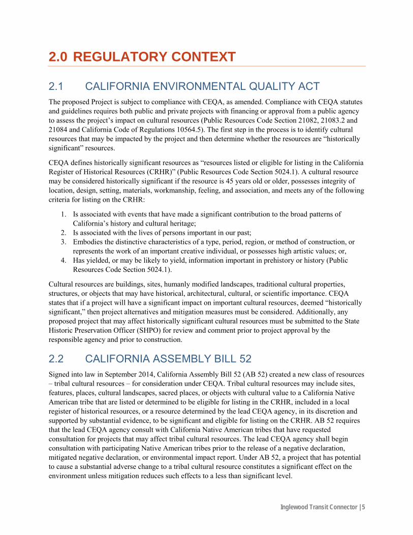
2.1 CALIFORNIA ENVIRONMENTAL QUALITY ACT The proposed Project is subject to compliance with CEQA, as amended. Compliance with CEQA statutes and guidelines requires both public and private projects with financing or approval from a public agency to assess the project’s impact on cultural resources (Public Resources Code Section 21082, 21083.2 and 21084 and California Code of Regulations 10564.5). The first step in the process is to identify cultural resources that may be impacted by the project and then determine whether the resources are “historically significant” resources.
CEQA defines historically significant resources as “resources listed or eligible for listing in the California Register of Historical Resources (CRHR)” (Public Resources Code Section 5024.1). A cultural resource may be considered historically significant if the resource is 45 years old or older, possesses integrity of location, design, setting, materials, workmanship, feeling, and association, and meets any of the following criteria for listing on the CRHR:
1. Is associated with events that have made a significant contribution to the broad patterns of California’s history and cultural heritage;
2. Is associated with the lives of persons important in our past; 3. Embodies the distinctive characteristics of a type, period, region, or method of construction, or
represents the work of an important creative individual, or possesses high artistic values; or, 4. Has yielded, or may be likely to yield, information important in prehistory or history (Public
Resources Code Section 5024.1).
Cultural resources are buildings, sites, humanly modified landscapes, traditional cultural properties, structures, or objects that may have historical, architectural, cultural, or scientific importance. CEQA states that if a project will have a significant impact on important cultural resources, deemed “historically significant,” then project alternatives and mitigation measures must be considered. Additionally, any proposed project that may affect historically significant cultural resources must be submitted to the State Historic Preservation Officer (SHPO) for review and comment prior to project approval by the responsible agency and prior to construction.
2.2 CALIFORNIA ASSEMBLY BILL 52 Signed into law in September 2014, California Assembly Bill 52 (AB 52) created a new class of resources – tribal cultural resources – for consideration under CEQA. Tribal cultural resources may include sites, features, places, cultural landscapes, sacred places, or objects with cultural value to a California Native American tribe that are listed or determined to be eligible for listing in the CRHR, included in a local register of historical resources, or a resource determined by the lead CEQA agency, in its discretion and supported by substantial evidence, to be significant and eligible for listing on the CRHR. AB 52 requires that the lead CEQA agency consult with California Native American tribes that have requested consultation for projects that may affect tribal cultural resources. The lead CEQA agency shall begin consultation with participating Native American tribes prior to the release of a negative declaration, mitigated negative declaration, or environmental impact report. Under AB 52, a project that has potential to cause a substantial adverse change to a tribal cultural resource constitutes a significant effect on the environment unless mitigation reduces such effects to a less than significant level.

Inglewood Transit Connector | 6
3.0 SETTING
This section of the report summarizes information regarding the physical and cultural setting of the Project area, including the prehistoric, ethnographic, and historic contexts of the general area. Several factors, including topography, available water sources, and biological resources, affect the nature and distribution of prehistoric, ethnographic, and historic-period human activities in an area. This background provides a context for understanding the nature of the cultural resources that may be identified within the region.
3.1 ENVIRONMENTAL SETTING The City of Inglewood is located at the southern edge of the Transverse Ranges geomorphic province, which includes the San Gabriel and San Bernardino mountains to the northeast, and the Santa Monica Mountains to the north. The City is also located near the northern boundary of the Peninsular Ranges geomorphic province, which includes the San Jacinto and Santa Rosa mountains and Newport-Inglewood Fault and the Whittier-Elsinore Fault to the east and southeast (City of Inglewood 2006). Most of the City is underlain by thick (10,000 to 12,000 foot) Tertiary and Quaternary marine and continental sedimentary rocks. The Tertiary rocks, consisting primarily of sandstone, silt-stone, and shale, are almost entirely of marine origin and range in age from Eocene to Pliocene. The Quaternary rocks consist of shallow marine sandstone and siltstone as well as continental siltstone, mudstone, and gravel (City of Inglewood 2006).
Specifically, however in the Baldwin and Rosecrans hills are geomorphic features associated with uplift along the Newport –Inglewood structural zone. Older Quaternary units are exposed in these strongly dissected hills, and elevations range from approximately 75 feet to over 400 feet (Department of Conservation 1998). To the east, Holocene alluvium lies upon the regional coastal basin, also known as the Downey Plain. The sediments overlie an erosional surface of late Pleistocene age. To the west of the Rosecrans Hills is an elevated plain underlain by older Quaternary alluvium.
This area contains a drainage basin, with Holocene sediments, that narrows to the south into the Dominguez Channel. Southwest of the Project, Pleistocene dune sand overlies older alluvial deposits. The main drainage courses within the area are the Dominguez Channel, Compton Creek, and Centinela Creek (Department of Conservation 1998). Prior to the development of the area the dominant plant community consist of coastal sage scrub, freshwater and salt marshes, and riparian woodlands. Common flora found within a coastal sage scrub community consist of California sagebrush (Artemisia californica), black sage (Salvia mellifera), white sage (Salvia apiana), California buckwheat (Eriogonum fasciculatum), coast brittle-bush (Encelia californica), golden yarrow (Eriophyllum confertifolium), and lemonade berry (Rhus integrifolia).
3.2 PREHISTORIC SETTING The most widely used chronological sequence in the Project vicinity distinguishes Early, Middle, and Late periods. It was initially outlined by King (1981) and later revised to include additional radiocarbon dates (King 1990) and to incorporate refinements in our understanding of cultural developments (Arnold 1992).

Inglewood Transit Connector | 7
3.2.1 Early Holocene (9600-5600 cal B.C.) Archaeological data compiled over the last two decades indicate that initial settlement along the coast of Southern California began at least 12,000 years before present (B.P.). Some of the earliest evidence of human occupation specifically derives from Daisy Cave (CA-SMI-261) on San Miguel Island where radiocarbon samples date the oldest cultural layer at the site between 9600 and 9000 cal B.C. (Erlandson et al. 1996). In the Southern California coastal region, the discovery of fluted projectile points indicates human use of the area possibly as early as possibly 13,000 years ago (Erlandson et al. 1996; Stickel 2010), while sites on San Miguel and Santa Rosa islands have yielded radiocarbon dates older than 10,000 years (Erlandson 1991; Johnson et al. 2001).
However, few known sites date to this earliest period (i.e., pre-10,000 years before present [B.P.]) and relatively few sites have been identified specifically within the Los Angeles Basin that date to the early Holocene. The earliest evidence of human occupation in the Los Angeles region is represented by a set of female human remains that were discovered in association with a handstone in the tar pits of Rancho La Brea in 1914 (Merriam 1914). Possible low population densities may explain the scarcity of sites dating to the early Holocene in the region, but the few known sites do suggest that they tend to be located on elevated landforms, and their presence on the Northern Channel Islands indicates early knowledge and use of marine resources. Diagnostic tools associated with this time period for coastal California have not been identified and cultural assemblages dating to this period have fewer of the grinding implements common to subsequent periods. Research suggests that inhabitants of this period lived in small groups that had a relatively egalitarian social organization and a forager-type land-use strategy (Erlandson 1994; Glassow 1996; Greenwood 1972; Moratto 1984).
3.2.2 Middle Holocene (5600–1650 cal B.C.) Shortly after 9,000 years ago, sites in the coastal region begin to be characterized by an abundance in milling tools, and the broader subsistence regime, including utilization of plants and seeds, terrestrial animals, and shellfish (Glassow 1996; Glassow et al. 1988; Sutton and Gardner 2010). Increasing populations composed of small, dispersed groups with more generalized tool kits, and a mixed subsistence regime indicating a heavier reliance on shellfish than on fish and terrestrial food sources are also identifiers of the period (Erlandson 1991, 1994, 1997). Population densities appear to have decreased substantially between 6500 and 5000 B.P. throughout the region, and little is known about this period. It has been suggested that the arid conditions associated with the Altithermal (a mid-Holocene period of predominantly warm/dry climate) damaged the environment to the point that only low population densities were sustainable (Glassow 1996; Glassow and Wilcoxon 1988).
After 5000 B.P., population densities increased significantly as conditions became cooler and moister. Between 5000 and 3000 B.P., mortars and pestles became increasingly common throughout the region, suggesting intensified use of acorns (Basgall 1987), as well as the possibility of pulpy roots or tubers (Glassow 1997). Large side-notched and stemmed projectile points became more prevalent, presumably reflecting increased hunting.
Coastal and inland sites of this time period exhibit shallow midden accumulations, suggesting seasonal camping. Based on the distribution of sites assigned to this period, larger groups likely occupied a base camp during a portion of the year, while smaller groups of people used satellite camps to exploit seasonally available floral resources such as grass seeds, berries, tubers, and nuts (cf. Binford 1980; Warren 1968). Site assemblages in coastal Southern California dating to this time contain numerous manos and metates, charmstones, cogged stones, discoidals, and some stone balls. A significant
Inglewood Transit Connector | 8
technological change in ground stone is seen at this time with the appearance of mortars and pestles which suggests the adoption of acorn, nut, and seed processing by coastal groups (Sutton and Gardner 2010). The quantity of projectile points also increases during this time, indicating a subsistence shift toward greater reliance on large game. Burial practices also suggest that society was primarily egalitarian (Glassow 1996). Secondary burials among coastal communities continue to be the dominant mortuary regime with a smaller number of flexed inhumations during the Middle Holocene.
3.2.3 Late Holocene (1650 cal. B.C.–cal A.D. 1542) Cultural complexity appears to have increased around 3000–2500 B.P. Mortuary data research suggests a substantial change in social organization and political complexity during this period (King 1990). According to King, high-status positions became hereditary and individuals began to accumulate wealth and control exchange systems. Arnold (1991, 1992) proposes that this evolutionary step in socioeconomic complexity occurred around 700–800 years ago. Technological innovation as well as a continued increase in cultural complexity marks the period between 2,500 and 800 years ago. Fishing and sea mammal hunting became increasingly important. This corresponds to the development of the tomol (plank canoe), single-piece shell fishhooks, and harpoons (Glassow 1996; King 1990). In addition, the bow and arrow was introduced during this period. Utilization of imported obsidian continued to increase during this period as well (Jones et al. 2007).
A number of these new cultural traits have been thought to be attributable to the arrival of Takic speaking people from the southern San Joaquin Valley in the coastal California region (Sutton 2009). Biological, archaeological, and linguistic data indicate that the Takic groups who settled in the Los Angeles Basin were ethnically distinct from the indigenous Hokan-speaking Topanga populations that had inhabited the region just north of the Project. These Takic speakers are believed to be ancestral to the ethnographic Gabrielino groups (Sutton 2009).
Due to the archaeological evidence gathered it is suggested that Hokan-speaking groups were largely replaced or subsumed by the Gabrielino and Chumash by 2000 B.P. (Sutton and Gardner 2010). Several new types of material cultural appear in the archaeological record during the 700 B.C.-1800 A.D. including the presence of Cottonwood series points, birdstone and “spike” effigies, Olivella cupped beads, and Mytilus shell disk beads. Additionally, the presence of Southwestern pottery, Patayan ceramic figurines, and Hohokam shell bracelets at some of these later sites suggests interaction between populations in Southern California and the Southwest. Additionally, potential changes in trade networks at this time may be evidenced by an increase in the number and size of steatite artifacts, including large vessels, elaborate effigies, and comals in the archaeological record.
3.3 ETHNOGRAPHIC SETTING The prehistory of California’s coast spans the entire Holocene and may extend back to late Pleistocene times. At the time of contact however, the ethnographic record indicates that the Gabrielino populations inhabited what is now known as the Los Angeles Basin and the Project region. Traditionally, the Gabrielino occupied a large territory, including the entire Los Angeles Basin, the coast from Malibu to Aliso Creek, parts of the Santa Monica Mountains, the San Fernando Valley, the San Gabriel Valley, the San Bernardino Valley, the northern part of the Santa Ana Mountains, and much of the middle and lower Santa Ana River reaches. In addition, the Gabrielino also inhabited the islands of Santa Catalina, San Clemente, and San Nicolas. The Gabrielino language was a Cupan language which is part of the Takic language family and part of a larger language group called Uto-Aztecan (Harrington 1981, Kroeber 1925).

Inglewood Transit Connector | 9
It is believed that more than 50 communities with populations that ranged from 50-150 individuals inhabited the traditional territory of the Gabrielino pre-contact. Each autonomous community or village consisted of one or more patrilineages that maintained permanent placement and the maintenance of surrounding hunting and gathering areas, and ceremonial sites as well. The chief, his family, and elite members were typically the epicenter of the village sites. The village members would encompass and surround the homes of the chief and elite with smaller houses/structures. Other common structures found in Gabrielino villages included sweathouses, clearings for ceremonies and playing fields, as well as cemeteries or burial grounds (McCawley 1996:32-33). Management of food and resources was implemented by the chief and food stores were also kept for each family when supply was low.
The material culture of the Gabrielino is elaborate and has been compared to that of the Chumash. Sources including Padre Geronimo Boscana’s accounts (Boscana 1846), Hugo Reid’s 1852 letters to the Los Angeles Star (Reid and Heizer 1968), and Harrington’s (Harrington 1981) early twentieth century interviews describe the common use of shell ornaments and beads, baskets, bone tools, flint weapons and drills, fishhooks, mortars and pestles, wooden bowls and paddles, shell spoons, wooden war clubs, and a variety of steatite items (cooking vessels, comals, ornaments) as many of artifact types common in descriptions of Gabrielino culture (Blackburn 1963). Additionally, artesian development has been observed in the artifact assemblage with the implementation of inlaid with shell (using asphalt) and in the steatite items from production centers on Catalina Island.
Trade was an important element of the Gabrielino economy. While the principal Gabrielino-produced commodity—steatite vessels from centers on Catalina Island—originated well outside the defined study region, trade in steatite items was conducted throughout local territory and involved external relations with desert, Southwestern, mountain, and coastal groups beyond Gabrielino borders (Kroeber 1925). Subsistence resources were also supplemented by additional supplies of deer skins, seeds, and acorns from interior groups such as the Serrano (Kroeber 1925:629). Additionally, Olivella shell callus beads, manufactured on the northern Channel Islands by the Chumash and their predecessors, were reportedly used quite frequently as a currency or as a status symbol by the Gabrielino and other Southern California groups.
As described in ethnographic sources, the subsistence resource base for the Gabrielino people included native grass seeds, six or more types of acorns, pinyon pine nuts, seeds and berries from various shrubs, fresh greens and shoots, mule deer, pronghorn, mountain sheep, rabbits and rodents, quail and waterfowl, snakes, lizards, insects, and freshwater fish, plus a wide variety of marine fish, shellfish, and sea mammals in coastal zones. Resource exploitation techniques were also described in ethnographic accounts and include rabbit drives in conjunction with seasonal controlled burning of chaparral, and the use of throwing sticks or nets in the capture of waterfowl in the low-lying marshlands. Reed rafts may have been employed for marshland hunting (Priestley 1937).
The first contact between the Europeans and the Gabrielino is thought to have occurred in 1542 when Juan Rodriguez Cabrillo’s small fleet arrived at Santa Catalina Island when the Spanish exploration of North America began in the early 1500s, and Juan Rodriguez Cabrillo began exploring the Alta California coastline in 1542. Additionally, contact with the Gabrieleno by the Spanish likely occurred again in 1602 with the Sebastían Vizcaíno expedition (McCawley 1996:207) and in 1769 with the Gaspar de Portolá expedition.
Mission San Gabriel was founded on September 8, 1771, but moved to its present location around 1774, due to the second location consisting of more suitable land for agriculture. A second mission, San Fernando, was established within Gabrielino territory in 1797. The assimilation of the Gabrielino people

Inglewood Transit Connector | 10
in to the mission system had gross negative affect on the traditional Gabrielino communities as they were depopulated, had become estranged from many of their traditional cultural practices, their lands, political autonomy, and had even become enslaved and even killed, and suffered from epidemics caused by the introduction of European diseases further reduced the indigenous population. Between 1832 and 1834, as the primary result of secularization of the former mission lands, which was theoretically designed to turn over ownership of some of the lands back to the Native peoples of California, consequently increased the displacement of the Gabrielino (McCawley 1996:208). The establishment of California as a state in 1850 brought further hardships to the Gabrielino, forcing many to eventually settle into smaller groups of Native American and Mexican settlements in places like the Eagle Rock and Highland Park districts of Los Angeles as well as in Pauma, Pala, Temecula, Pechanga, and San Jacinto.
3.4 HISTORICAL SETTING Spanish exploration of North America in the early 1500s marked some of the first European contact with the indigenous peoples of the area now known as Los Angeles and the Project region. The mission system was established by the Catholic Church and the Spaniards to settle, colonize the Native Americans to utilize their labor to develop the lands, and spread Catholicism from Baja California to what is known today as northern California. The first mission was established in 1769 in present-day San Diego. The mission system’s goal was for each mission to be self-sustaining. This required the conversion of indigenous peoples in order to claim lands in the name of Spain and required the Native American population to grow crops, raise livestock, and sustain the mission settlement and provide commodities for trade. The Mission San Gabriel Archangel was the fourth mission established in Alta California in 1771. The Native Americans that traditionally inhabited the region of the Project were assimilated into the Mission San Gabriel.
In addition to establishing the mission system in 1779, Spanish settlement of Alta California also included the establishment of pueblos and presidios. These settlements were used as bases from which to colonize the rest of California. The Spanish also laid out pueblos, or towns along the coast. Providing supplies, animals, and colonists to the Spanish missions and presidios by way of ship was difficult, time-consuming, expensive, and dangerous. Thus, an overland route was necessary to initiate a strong colonizing effort in Alta California. The City of Los Angeles was initially established by a mixed group of settlers, known as the Pobladores, as a pueblo in 1781 (Starr 2005:37). The original site of the plaza was constructed within the Los Angeles River floodplain but was moved to its current location after flooding a quickly became a center for economic, political, and social/cultural activities.
While much of the land in California was under the supervision of the Spanish missions, the Spanish government granted lands to individuals that had served the government (Beedle et al, 2008). Additionally, when Mexico achieved independence from Spain in 1821, the Spanish mission system became subject to the Secularization Act in 1833 where all mission lands became property of the new Mexican government. The former mission lands were divided into smaller land grants and distributed to prominent and wealthy Mexican military officers and families. Between 1835 and 1846, more than 600 land grants in Alta California were recorded with the Mexican government, including the Rancho Palos Verdes and Rancho Sn Pedro Dominguez in the Carson and Wilmington areas which are just south of the Project (Robinson 1948: 12-13; Starr 2005:49-51). As a result of Mexican independence, marine-based trade expanded as California ports were opened to foreign trade.
With the signing of the Treaty of Guadalupe-Hidalgo on February 2, 1848, California formally became an American territory, and two years later, on September 9, 1850, California became the thirty-first state in the Union. Prior to becoming a state, California was divided into 27 counties, and Los Angeles was one of
Inglewood Transit Connector | 11
them. In addition to California being granted statehood, the City of Los Angeles also became incorporated in 1850. In those two years (1848–1850) there was an influx of Americans to California seeking their fortunes, triggered by James Marshall’s 1848 discovery of gold at Sutter’s Mill. However, statehood and an extensive drought in the 1860s eventually ended the prosperity of the ranchos (Beedle et al, 2008).
Yet, before the drought in the 1860s, a Land Commission was established in 1851 and its purpose was to verify the ownership claims of ranchos in California. Oftentimes, ownership of the ranchos was deemed invalid, consequently opening large tracts of land for purchase. Men such as Abel Stearns, James Irvine, and Llewellyn Bixby, who were notable individuals involved in the development of Southern California were able to take advantage of these newly available lands (Starr 2005:104; Cleland 1966:57-59). Although much of the lands changed ownership, the economy of the time remained largely based on agriculture with an emphasis on raising livestock and crops.
To maintain economic independence, Los Angeles was also established as a port of entry in 1853 to compete with the previously established San Francisco port. However, the port was too shallow and consisted of a rocky shoreline. Phineas Banning, David W. Alexander, and Augustus W. Timms lead efforts to reestablish the port at the Port of Los Angeles in San Pedro. Additionally, population increases in the area was brought on with the onset of the Civil War by the U.S. government establishing military posts in the Los Angeles area on lands donated by individuals like Phineas Banning and B.D. Wilson.
Development boom also occurred with the establishment of rail lines in California that made stagecoach companies obsolete. The establishment of a Southern Pacific Railroad and its completed Los Angeles route in 1880 and the Santé Fe Railway in 1886. Banning also successfully lobbied for a branch of the Southern Pacific Railroad to connect the port to Los Angeles. The establishment of these rail lines further boosted Los Angeles’ role in the economic development of Southern California and the United States (Starr 2005:114-118).
The city of Inglewood, where the Project lies, was the first settlement to be established from the formerly known Rancho Agape de la Cantilena in 1888 shortly after a railroad station was constructed in the area. The town consisted of 300 residents at the time and in 1908 the city became incorporated. Inglewood recovered from the nationwide financial crash prior to that in 1905 and established the Poultry Colony in present-day North Inglewood. Additionally, the Inglewood Park Cemetery, located within the northern portion of the Project was developed and the street car line brought both coffins and mourners to the cemetery.
After the earthquake of 1920, many visitors came to observe the damage in Inglewood but stayed due to the pleasant climate. From 1920 to 1925 the city was the fastest growing city in the United States (City of Inglewood, 2018). Until World War II, Inglewood had been a hub for agriculture, but defense industries transformed it into an urban community when industrial activity, stimulated by the war, brought new workers and their families to the city.
During the 1960s and 1970s, the city continued taking on its more metropolitan look and became racially integrated in both residential and business sectors. The city of Inglewood continues to be valued for its access to the major freeways and the now established Los Angeles Airport.
Inglewood Transit Connector | 12
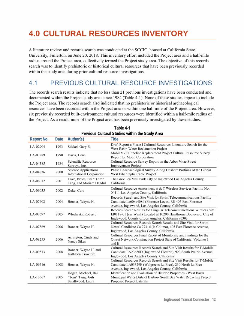
4.0 CULTURAL RESOURCES INVENTORY
A literature review and records search was conducted at the SCCIC, housed at California State University, Fullerton, on June 20, 2018. This inventory effort included the Project area and a half-mile radius around the Project area, collectively termed the Project study area. The objective of this records search was to identify prehistoric or historical cultural resources that have been previously recorded within the study area during prior cultural resource investigations.
4.1 PREVIOUS CULTURAL RESOURCE INVESTIGATIONS The records search results indicate that no less than 21 previous investigations have been conducted and documented within the Project study area since 1984 (Table 4-1). None of these studies appear to include the Project area. The records search also indicated that no prehistoric or historical archaeological resources have been recorded within the Project area or within one half mile of the Project area. However, six previously recorded built-environment cultural resources were identified within a half-mile radius of the Project. As a result, none of the Project area has been previously investigated by these studies.
Table 4-1
Previous Cultural Studies within the Study Area
Report No. Date Author(s) Title
LA-02904 1993 Stickel, Gary E. Draft Report a Phase I Cultural Resources Literature Search for the West Basin Water Reclamation Project
LA-03289 1990 Davis, Gene Mobil M-70 Pipeline Replacement Project Cultural Resource Survey Report for Mobil Corporation
LA-04385 1984 Scientific Resource Surveys, Inc.
Cultural Resource Survey Report on the Arbor Vitae Street Improvement Project
LA-04836 2000 Science Applications International Corporation
Phase I Archaeological Survey Along Onshore Portions of the Global West Fiber Optic Cable Project
LA-06012 2001 Love, Bruce, Bai " Tom" Tang, and Mariam Dahdul
The Grevillea Mall Park City of Inglewood Los Angeles County, California
LA-06035 2002 Duke, Curt Cultural Resource Assessment at & T Wireless Services Facility No. 04111 Los Angeles County, California
LA-07402 2004 Bonner, Wayne H. Records Search and Site Visit for Sprint Telecommunications Facility Candidate La60xc408d (Florence Locust Rl) 405 East Florence Avenue, Inglewood, Los Angeles County, California
LA-07697 2005 Wlodarski, Robert J. Records Search Results for Cingular Telecommunications Wireless Site El0118-01 (car Wash) Located at 10200 Hawthorne Boulevard, City of Inglewood, County of Los Angeles, California 90303
LA-07869 2006 Bonner, Wayne H. Cultural Resources Records Search Results and Site Visit for Sprint Nextel Candidate Ca 7731d (la Colima), 405 East Florence Avenue, Inglewood, Los Angeles County, California
LA-08255 2006 Arrington, Cindy and Nancy Sikes
Cultural Resources Final Report of Monitoring and Findings for the Qwest Network Construction Project State of California: Volumes I and Ii
LA-09513 2008 Bonner, Wayne H. and Kathleen Crawford
Cultural Resources Records Search and Site Visit Results for T-Mobile Candidate LA23650D (Inglewood Electric), 923 South Prairie Avenue, Inglewood, Los Angeles County, California
LA-09516 2008 Bonner, Wayne H. Cultural Resources Records Search and Site Visit Results for T-Mobile Candidate LA03329E (Walgreens La Brea), 230 North La Brea Avenue, Inglewood, Los Angeles County, California
LA-10567 2005 Hogan, Michael, Bai "Tom" Tang, Josh Smallwood, Laura
Identification and Evaluation of Historic Properties - West Basin Municipal Water District Harbor- South Bay Water Recycling Project Proposed Project Laterals

Inglewood Transit Connector | 13
Table 4-1
Previous Cultural Studies within the Study Area
Report No. Date Author(s) Title Hensley Shaker, and Casey Tibbitt
LA-10685 2010 Bonner, Wayne and Kathleen Crawford
Cultural Resources Records Search, Site Visit Results, and Direct APE Historic Architectural Assessment for Clearwire Candidate CA-LOS2089/CA6588, 336 East Hillcrest Boulevard, Inglewood, Los Angeles, California
LA-11150 2003 Maxwell, Pamela West Basin Municipal Water District Harbor/ South Bay Water Recycling Project
LA-11174 1998 Kadara, Kayode Inglewood Main Post Office, Inglewood, Los Angeles County
LA-11396 2011 Loftus, Shannon
Cultural Resource Records Search and Site Survey AT&T Site LA0021, Inglewood Cemetery, 724 East Manchester Boulevard, Inglewood, Los Angeles County, California 90301 CASPR# 3551015375
LA-11414 2011 Loftus, Shannon
Historic Architectural Resource Inventory and Assessment, AT&T Site LA0021, Inglewood Cemetery, 724 East Manchester Boulevard, Inglewood, Los Angeles County, California 90301 CASPR #3551015375
LA-11974 2012 Morell, Karl Abandonment Exemption, BNSF Railway Company, Milepost 7.95 to Milepost 13.25, Los Angeles, Los Angeles County, CA
LA-12189 2013 Bonner, Wayne and Crawford, Kathleen
Cultural Resources Records Search and Site Visit Results for T-Mobile West, LLC Candidate LA02636A (LA636 Medical Building) 336 East Hillcrest Boulevard, Inglewood, California
LA-12352 2012 Rendon, Richard Federal Land and Water Conservation Fund Program under the National Park Service Edward Vincent Park Multi-Purpose Field Rehabilitation Project, City of Inglewood
4.2 CULTURAL RESOURCES REPORTED WITHIN THE STUDY AREA
The records search indicated that no prehistoric or historical archaeological resources have been recorded within the Project area or within one half mile of the Project area. However, six previously recorded built-environment cultural resources were identified within a half-mile radius of the Project. One of these resources, 19-189809, is a multi-story commercial building that is located immediately adjacent to the Project area and may be directly or indirectly impacted by the Project. In addition, five buildings/structures, located immediately adjacent to the Project area, are listed on the Directory of Historic Properties Data File. These resources may be directly or indirectly impacted by the Project as well. PaleoWest understands that a separate built-environment resource study is being prepared for this Project. As such, these resources will not be considered further during the cultural resource study conducted by PaleoWest.
4.3 ADDITIONAL SOURCES Additional sources consulted during the cultural resource literature review and records search include the National Register of Historic Places, the Office of Historic Preservation Archaeological Determinations of Eligibility, and the Office of Historic Preservation Directory of Properties in the Historic Property Data File. There are no listed archaeological resources recorded within the Project area or within one half mile of the Project area.

Inglewood Transit Connector | 14
4.4 NATIVE AMERICAN COORDINATION PaleoWest contacted the NAHC, as part of the cultural resource assessment, on June 15, 2018, for a review of the SLF. The objective of the SLF search was to determine if the NAHC had any knowledge of Native American cultural resources (e.g., traditional use or gathering area, place of religious or sacred activity, etc.) within the immediate vicinity of the Project area. The NAHC responded on June 19, 2018, stating that the SLF was completed with negative results. However, the NAHC did state that the absence of specific site information in the SLF does not indicate the absence of Native American cultural resources (Appendix A). As such, the NAHC recommended that five Native American individuals and/or tribal groups be contacted to elicit information regarding cultural resource issues related to the proposed Project. PaleoWest sent outreach letters to the recommended tribal groups on July 27, 2018 after conducting the pedestrian survey of the Project area on July 20, 2018. These letters were followed up by phone calls on August 29, 2018.
To date responses have been received from three of the five contacted individuals/tribal groups. Mr. Andy Salas of the Gabrieleno Band of Mission Indians- Kizh Nation requested that an email be sent with the lead agency’s contact information so that he might contact the lead agency directly with his comments regarding the Project. Mr. Salas was informed that the City would be conducting Assembly Bill 52 consultation efforts at a later date and, at that time, the City would be contacting him directly to provide his comments. Mr. Anthony Morales of the Gabrieleno/Tongva San Gabriel Band of Mission Indians stated that the Project lies within a highly sensitive cultural area and that any trenching or excavation for structures such as support columns would likely require archaeological and Native American monitoring. Additionally, Mr. Morales recommended monitoring and requests consultation for the Project. Lastly, Mr. Robert Dorame of the Gabrielino Tongva Indians of California Tribal Council requested that the original email be resent and that he would like to consult with other Tribal Members before offering official comments and recommendations regarding the Project. The email was resent to Mr. Dorame on August 29, 2018.

Inglewood Transit Connector | 15
5.0 FIELD INVESTIGATION
5.1 FIELD METHODS A windshield/reconnaissance survey of the Project area was conducted by PaleoWest archaeologist Oliver Hegge on July 20, 2018. The purpose of the survey was to observe and note the conditions of the Project area including the extent of the hardscape, the overall degree of ground disturbance, and the character and nature of the Project area. The surveyor drove the length of the APM alignment to identify any areas of open ground surface. He carefully inspected any areas within the Project area likely to contain or exhibit archaeologically or historically sensitive cultural resources and inspected to ensure that if any visible, potentially significant archaeological resources were discovered that they were documented.
The Project area was recorded with digital photographs for use in the report. Photographs included general views of the topography and vegetation density, and other relevant images. A photo log was maintained to include, at a minimum, photo number, date, orientation, photo description, and comments.
One of the primary goals of the reconnaissance survey was to identify historical and prehistoric site indicators. Examples of historical indicators include fence lines, ditches, standing buildings, objects or structures such as sheds, or concentrations of materials at least 45 years in age, such as domestic refuse (e.g., glass bottles, ceramics, toys, or buttons), refuse from other pursuits such as agriculture (e.g., metal tanks, farm machinery parts, horse shoes) or structural materials (e.g., nails, glass window panes, corrugated metal, wood posts or planks, metal pipes and fittings, railroad spurs, etc.). Examples of prehistoric site indicators include areas of darker soil with concentrations of ash, charcoal, animal bone (burned or unburned), shell, flaked stone, ground stone, pottery, or human bone.
5.2 FIELD RESULTS The windshield/reconnaissance survey revealed that the majority of the Project area includes residential or commercial structures with associated landscaping and hardscaping. As such, the ground surface within the Project area is almost entirely obscured by hardscape that includes buildings, paved driveways, curbs and sidewalks, paved roadways, and parking lots. The limited small portions of the Project area that lack hardscape are characterized by landscaped lawns and yards associated with residences and businesses as well as what appear to be two or three vacant lots. Due to the lack of ground visibility and extensive disturbance from the built environment, field documentation consisted of general observations and digital photography.
No historical or prehistoric archaeological resources were observed within the Project area during the windshield/reconnaissance survey. However, six previously recorded built-environment cultural resources were identified within a half-mile radius of the Project during the records search. These resources may be directly or indirectly impacted by the Project; however, are not discussed in this study.

Inglewood Transit Connector | 16
Figure 5-1 Market and Regent Street intersection, view to the south
Figure 5-2 Kelso and Prarie Avenue intersection, view to the south

Inglewood Transit Connector | 17
Figure 5-3 Overview of proposed Hollywood Park stop, view to the north
Figure 5-4 Overview of proposed facility site, view to the northwest

Inglewood Transit Connector | 18
6.0 MANAGEMENT RECOMMENDATIONS
The cultural resource records search and field visit did not result in identifying any prehistoric or historical archaeological resources within the Project area. However, the ground visibility within the Project area was very poor; the APM alignment as well as the MSF and ITF locations are almost entirely hardscaped. The built nature of the Project area indicates a high degree of disturbance suggesting the likelihood of encountering intact archaeological deposits near the surface of the Project area to be very low. The Gabrieleno Band of Mission Indians- Kizh Nation and Gabrieleno/Tongva San Gabriel Band of Mission Indians both requested to consult the City on the Project. Additionally, the Gabrieleno/Tongva San Gabriel Band of Mission Indians indicated a high sensitivity for cultural resources in the Project and requested cultural and Native American monitoring be conducted for the proposed Project. However, as previously stated, the high degree of urban development disturbance suggests the likelihood of encountering intact archaeological resources is low. PaleoWest does not recommend any additional cultural resource management for the proposed Project.
In the event that potentially significant archaeological materials are encountered during Project-related ground-disturbing activities, all work should be halted in the vicinity of the archaeological discovery until a qualified archaeologist can visit the site of discovery and assess the significance of the archaeological resource. In addition, Health and Safety Code 7050.5, CEQA 15064.5(e), and Public Resources Code 5097.98 mandate the process to be followed in the unlikely event of an accidental discovery of any human remains in a location other than a dedicated cemetery. Finally, should additional actions be proposed outside the currently defined Project area that have the potential for additional subsurface disturbance, further cultural resource management may be required.

Inglewood Transit Connector | 19
7.0 REFERENCES
Arnold, Jeanne 1991 Transformation of a Regional Economy: Sociopolitical Evolution and the Production of
Valuables in Southern California. American Antiquity 56:953–962.
1992 Complex Hunter-Gatherer-Fishers of Prehistoric California: Chiefs, Specialists, and Maritime Adaptations of the Channel Islands. American Antiquity 57:60–84.
Basgall, Mark E.
1987 Resource Intensification among Hunter-Gatherers: Acorn Economies in Prehistoric California. Research in Economic Anthropology 9:21–52.
Beedle, Peggy, Keith Warren, and David Earle 2008 Phase I Cultural Resources Survey Simi Valley Landfill and Recycling Center Expansion,
Simi Valley, California. Applied EarthWorks, Inc. Binford, L. R.
1980 Willow Smoke and Dogs’ Tails: Hunter Gatherer Settlement Systems and Archaeological Site Formation. American Antiquity 45:4–20.
Blackburn, Thomas
1963 Ethnohistoric Descriptions of Gabrielino Material Culture. UCLA Archaeological Survey Annual Reports 5:1–50.
Boscana, Gerónimo 1846 "Chinigchinich; a Historical Account of the Origin, Customs, and Traditions of the Indians at
the Missionary Establishment of St. Juan Capistrano, Alta California Called The Acagchemem Nation." From Life in California by Alred Robinson. Pp. 227-341. New York, Wiley & Putnam.
City of Inglewood
2006 City of Inglewood Technical Background Report. City of Inglewood. 2018 City History. City of Inglewood. https://www.cityofinglewood.org/512/City-History.
Cleland, Robert Glass
1966 The Irvine Ranch. Huntington Library, San Marino, California.
Department of Conservation 1998 Seismic Hazard Zone Report for the Inglewood 7.5-Minute Quadrangle, Los Angeles County,
California. Department of Conservation: Division of Mines and Geology. Erlandson, Jon M.
1991 Early Maritime Adaptations on the Northern Channel Islands. In Hunters and Gatherers of Early Holocene Coastal California, edited by Jon M. Erlandson and Roger H. Colten, pp. 101–111. Perspectives in California Archaeology, vol. 1. Institute of Archaeology, University of California, Los Angeles.

Inglewood Transit Connector | 20
Erlandson, Jon M. (continued) 1994 Early Hunter-Gatherers of the California Coast. Plenum, New York.
1997 The Middle Holocene along the California Coast. In Archaeology of the California Coast during the Middle Holocene, edited by Jon M. Erlandson and Michael A. Glassow, pp. 1–10. Perspectives in California Archaeology, vol. 4. Institute of Archaeology, University of California, Los Angeles.
Erlandson, Jon M., Douglas J. Kennett, B. Lynn Ingram, Daniel A. Guthrie, Don P. Morris, Mark A. Tveskov, G. James West, and Phillip L. Walker
1996 An Archaeological and Paleontological Chronology for Daisy Cave (CA-SMI-261), San Miguel Island, California. Radiocarbon 38(2):355–373.
Glassow, Michael A. 1996 Purisimeño Chumash Prehistory: Maritime Adaptations along the Southern California Coast.
Case Studies in Archaeology. Jeffrey Quilter, series editor. Harcourt Brace College Publishers, San Diego, California.
1997 Middle Holocene Cultural Development in the Central Santa Barbara Channel Region. In Archaeology of the California Coast during the Middle Holocene, edited by Jon M. Erlandson and Michael A. Glassow, pp. 73–90. Perspectives in California Archaeology, vol. 4. Institute of Archaeology, University of California, Los Angeles.
Glassow, Michael, and Larry Wilcoxon 1988 Coastal Adaptations near Point Conception, California, with Particular Regard to Shellfish
Exploitation. American Antiquity 53(1):36–51.
Glassow, Michael A., Larry R. Wilcoxon, and Jon Erlandson 1988 Cultural and Environmental Change during the Early Period of Santa Barbara Channel
Prehistory. In The Archaeology of Prehistoric Coastlines, edited by Geoff N. Bailey and John E. Parkington, pp. 64–77. Cambridge University Press.
Greenwood, Roberta
1972 Obispeño and Purisimeño Chumash. In California, edited by Robert F. Heizer, pp. 520–523. Handbook of North American Indians, vol. 8, William C. Sturtevant, general editor. Smithsonian Institution, Washington, D.C.
Harrington, John Peabody
1981 The Papers of John Peabody Harrington in the Smithsonian Institution 1907–1957. Edited by Elaine L. Mills and Ann J. Brickfield, Vol. 3. Kraus International Publications, White Plains, New York.
Johnson, John R., Thomas W. Stafford, Jr., Henry O. Ajie, and Don P. Morris 2001 Arlington Springs Revisited. In Proceedings of the Fifth California Islands Symposium,
edited by D. R. Brown, K. C. Mitchell, and H. W. Chaney, pp. 541–545. Santa Barbara Museum of Natural History, Santa Barbara, California.
Jones, Terry L., Nathan E. Stevens, Deborah A. Jones, Richard T. Fitzgerald, and Mark G. Hylkema 2007 The Central Coast: A Midlatitude Milieu. In California Prehistory: Colonization, Culture,
and Complexity, edited by Terry L. Jones and Kathryn A. Klar, pp. 125-146. AltaMira Press,

Inglewood Transit Connector | 21
Lanham, Maryland.
King, Chester D. 1981 The Evolution of Chumash Society: A Comparative Study of Artifacts Used in Social System
Maintenance in the Santa Barbara Channel Region before A.D. 1804. Ph.D. dissertation, Department of Anthropology, University of California, Davis, California.
1990 Evolution of Chumash Society: A Comparative Study of Artifacts Used for Social System Maintenance in the Santa Barbara Channel Region before A.D. 1804. The Evolution of North American Indians, edited by David Hurst Thomas. Garland, New York.
Kroeber, Albert L. 1925 Handbook of the Indians of California. Bureau of American Ethnology Bulletin 78.
Washington, D.C.
McCawley, W. 1996 The First Angelinos: The Gabrielino Indians of Los Angeles. Malki Museum Press, Banning,
California and Ballena Press, Novato, California. Merriam, J. C.
1914 Preliminary Report on the Discovery of Human Remains in an Asphalt Deposit at Rancho La Brea, Science 40:197–203.
Moratto, Michael J.
1984 California Archaeology. Academic Press, New York and London. Reprinted, with new Introduction, 2004, Coyote Press, Salinas, California.
Priestley, H. J. 1937 A Historical, Political, and Natural Description of California by Pedro Fages, Soldier of
Spain. University of California Press, Berkeley Reid, Hugo, and Robert F. Heizer
1968 The Indians of Los Angeles County: Hugo Reid’s Letters of 1852. Southwest Museum Papers, No. 21. Southwest Museum, Los Angeles.
Robinson, W. W.
1948 Land in California: the Story of Mission Lands, Ranchos, Squatters, Mining Claims, Railroad Grants, Land Scrip, Homesteads. University of California Press, Berkeley.
Starr, Kevin
2005 California: A History. Modern Library, New York. Stickel, E. Gary
2010 Ice Age Man in Malibu: The Clovis Culture Discovery at the Farpoint Site. Presentation to the Pacific Coast Archaeological Society, March 11, Irvine, California.
Sutton, Mark Q. 2009 People and Language: Defining the Takic Expansion in Southern California. Pacific Coast
Archaeological Society Quarterly 41(2–3):31–93.

Inglewood Transit Connector | 22
Sutton, Mark Q., and Jill K. Gardner 2010 Reconceptualizing the Encinitas Tradition of Southern California. Pacific Coast
Archaeological Society Quarterly 42(4):1–64.
Warren, Claude N. 1968 Cultural Tradition and Ecological Adaptation on the Southern California Coast. Eastern New
Mexico University Contributions in Archaeology 1(3):1–15.

Appendix A. Native American Coordination

STATE OF CALIFORNIA Edmund G. Brown, Jr., Gov er n or
NATIVE AMERICAN HERITAGE COMMISSION Cultural and Environmental Department 1550 Harbor Blvd., Suite 100 West Sacramento, CA 95691 (916) 373-3710
CONFIDENTIALITY NOTICE: This communication with its contents may contain confidential and/or legally privileged information. It is solely for the use of the intended recipient(s). Unauthorized interception, review, use or disclosure is prohibited and may violate applicable laws including the Electronic Communications Privacy Act. If you are not the intended recipient, please contact the sender and destroy all copies of the communication.
June 19, 2018
Robbie Thomas PaleoWest Archaeology Sent by E-mail: [email protected] RE: Proposed Inglewood Transit Interconnect (18-195) Project, City of inglewood; Inglewood USGS Quadrangle, Los Angeles County, California Dear Ms. Thomas:
A record search of the Native American Heritage Commission (NAHC) Sacred Lands File was completed for the area of potential project effect (APE) referenced above with negative results. Please note that the absence of specific site information in the Sacred Lands File does not indicate the absence of Native American cultural resources in any APE.
Attached is a list of tribes culturally affiliated to the project area. I suggest you contact all
of the listed Tribes. If they cannot supply information, they might recommend others with specific knowledge. The list should provide a starting place to locate areas of potential adverse impact within the APE. By contacting all those on the list, your organization will be better able to respond to claims of failure to consult. If a response has not been received within two weeks of notification, the NAHC requests that you follow-up with a telephone call to ensure that the project information has been received.
If you receive notification of change of addresses and phone numbers from any of these individuals or groups, please notify me. With your assistance we are able to assure that our lists contain current information. If you have any questions or need additional information, please contact via email: [email protected].
Sincerely, Gayle Totton, M.A., PhD. Associate Governmental Program Analyst (916) 373-3714
Gayle Totton

Gabrieleno Band of Mission Indians - Kizh NationAndrew Salas, ChairpersonP.O. Box 393 Covina, CA, 91723Phone: (626) 926 - [email protected]
Gabrieleno
Gabrieleno/Tongva San Gabriel Band of Mission IndiansAnthony Morales, ChairpersonP.O. Box 693 San Gabriel, CA, 91778Phone: (626) 483 - 3564Fax: (626) [email protected]
Gabrieleno
Gabrielino /Tongva NationSandonne Goad, Chairperson106 1/2 Judge John Aiso St., #231 Los Angeles, CA, 90012Phone: (951) 807 - [email protected]
Gabrielino
Gabrielino Tongva Indians of California Tribal CouncilRobert Dorame, ChairpersonP.O. Box 490 Bellflower, CA, 90707Phone: (562) 761 - 6417Fax: (562) [email protected]
Gabrielino
Gabrielino-Tongva TribeCharles Alvarez, 23454 Vanowen Street West Hills, CA, 91307Phone: (310) 403 - [email protected]
Gabrielino
1 of 1
This list is current only as of the date of this document. Distribution of this list does not relieve any person of statutory responsibility as defined in Section 7050.5 of the Health and Safety Code, Section 5097.94 of the Public Resource Section 5097.98 of the Public Resources Code. This list is only applicable for contacting local Native Americans with regard to cultural resources assessment for the proposed Inglewood Transit Interconnect Project, Los Angeles County.
PROJ-2018-003464
06/19/2018 08:56 AM
Native American Heritage CommissionNative American Contact List
Los Angeles County6/19/2018

July 27, 2018
Andrew Salas, Chairperson Gabrieleno Band of Mission Indians – Kizh Nation P.O. Box 393 Covina, CA 91723 Transmitted via [email protected]
Re: Cultural Resource Investigation for the Inglewood Connector Project, Inglewood, Los Angeles County, California
Dear Mr. Salas,
On behalf of Meridian Consultants, PaleoWest Archaeology (PaleoWest) is conducting a cultural resource investigation, in compliance with the California Environmental Quality Act (CEQA), for the proposed Inglewood Connector Project (Project) within the city of Inglewood, in Los Angeles County, California. The proposed Project involves development of an elevated Automated People Mover along an aerial alignment that will provide service to Downtown Inglewood, the Forum, the Hollywood Park Development/NFL Stadium, and the Basketball and Entertainment Center. The Project area is located on the Inglewood, Calif. 7.5’ USGS quadrangle map, within Sections 28, 33, 34 (Civil Colonies land grant) in T2S/R14W (see attached map).
A cultural resource literature review and records search conducted at the South Central Coastal Information Center (SCCIC) housed at California State University, Fullerton, indicates that no less than 21 cultural resource studies have been conducted within a one-half-mile radius of the Project area. Five of these studies appear to include portions or all of the Project area. The records search also indicated that no prehistoric or historic archaeological resources have been identified within a one-half-mile radius of the Project area. PaleoWest conducted a reconnaissance survey of the Project area and did not identify any archaeological resources as a result of the survey.
As part of the cultural resource investigation of the Project area, PaleoWest requested a search of the Native American Heritage Commission’s (NAHC’s) Sacred Lands File on June 15, 2018. The NAHC responded on June 19, 2018 indicating that no Native American cultural resources were identified within the Project area. However, should your records show that cultural properties exist within or near the Project area shown on the enclosed map, please contact me at (626) 408-8006 or via e-mail at [email protected]. I will follow-up phone call or email if I do not hear from you.
Your comments are very important to us, and to the successful completion of this Project. I look forward to hearing from you in the near future. Thank you, in advance, for taking the time to review this request.
Respectfully yours,
Roberta Thomas, M.A., RPA Senior Archaeologist PaleoWest Archaeology
SAMPLE

Service Layer Credits: Copyright:© 2013National Geographic Society, i-cubed
Inglewood
0 2,000 4,0001,000 Feet
1:24,000´
SAMPLE

Recommended Contacts (Name and
Tribal Affiliation)Initial Contact
Follow up
AttemptsComments/Notes
Andrew Salas, Chairperson, Gabrieleno Band of Mission Indians – Kizh Nation
Letter/email dated July 27, 2018
Phone call, August 29, 2018
Mr. Salas requested the lead agency's contact information so that he send his comments regarding the Project direclty to the lead agency. Mr. Salas was informed that the lead agency would be conducting formal AB 52 consultation at a later date and would reach out to him directly for him comments.
Anthony Morales, Chairperson, Gabrieleno/Tongva San Gabriel Band of Mission Indians
Letter/email dated July 27, 2018
Phone call, August 29, 2018
Mr. Morales stated that the Project lies within a highly culturally sensitive area and that any trenching or excavation for structures such as support columns may require archaeological and Native American monitoring. He stated that he recommends monitoring and requests consultation.
Sandonne Goad, Chairperson, Gabrielino/Tongva Nation
Letter/email dated July 27, 2018
Phone call, August 29, 2018 Left a message for Ms. Goad.
Robert Dorame, Chairperson, Gabrielino Tongva Indians of California Tribal
Letter/email dated July 27, 2018
Phone call, August 29, 2018
Mr. Dorame requested that the original email be resent. Email resent on August 29, 2018. Mr. Dorame stated that he would like to consult with other Tribal Members before offering official comments and recommendations.
Charles Alvarez, Chairperson, Gabrielino-Tongva Tribe
Letter/email dated July 27, 2018
Phone call, August 29, 2018 Left a message for Mr. Alvarez.
Native American Contact/Response Matrix

4.4.2
Historic Resources Impact Memo

HISTORICAL RESOURCES TECHNICAL REPORT
Inglewood Transit Connector November 19, 2020 HISTORIC RESOURCES GROUP
12 S. Fair Oaks Avenue, Suite 200, Pasadena, CA 91105-3816 Telephone 626 793 2400, Facsimile 626 793 2401 www.historicresourcesgroup.com

HISTORICAL RESOURCES TECHNICAL REPORT
Inglewood Transit Connector HISTORIC RESOURCES GROUP
PREPARED FOR
Trifiletti Consulting 1545 Wilshire Blvd., Suite 700, Los Angeles, CA 90017
COVER PHOTO: Market Street, looking south from Regent Street, 1960. (Inglewood Public Library, Online Archive of California)

HISTORICAL RESOURCES TECHNICAL REPORT
Inglewood Transit Connector HISTORIC RESOURCES GROUP
TABLE OF CONTENTS
1.0 Summary of Findings 1
2.0 Proposed Project 2
3.0 Methodology 5
4.0 Regulatory Setting 8
5.0 Historic Context 15
6.0 Identification of Historical Resources 35
7.0 Potential Impacts 50
8.0 Recommended Mitigation Measures 67
Bibliography 69
Appendix A: Field Photographs
Appendix B: List of Parcels in the Project Area and Expanded Study Area

HISTORICAL RESOURCES TECHNICAL REPORT
Inglewood Transit Connector HISTORIC RESOURCES GROUP
1 1.0 SUMMARY OF FINDINGS
Historic Resources Group has completed this historical resources technical report to inform environmental review of the proposed Inglewood Transit Connector Project (the Project) under the California Environmental Quality Act (CEQA). The purpose of this report is to determine if historical resources as defined by CEQA are present within the Inglewood Transit Connector project area or immediate vicinity, and to identify potential impacts of the Project to those historical resources and how those impacts might be mitigated.
This report identifies a total of eleven (11) historical resources in the Project Area or Expanded Study Area for the Project. Of these, two (2) are listed in the National Register, and are therefore automatically listed in the California Register; four (4) were previously identified as historic through historic resources surveys, environmental review, or other efforts, and have been re-evaluated as appearing eligible for listing in the National Register and/or California Register; and five (5) were identified through this process and evaluated as appearing eligible for listing in the National Register and/or California Register. All of these properties are considered herein as historical resources for the purposes of CEQA. Therefore, potential impacts of the Project to these properties are analyzed.
As detailed in this report, the Project will result in both direct and indirect impacts to historical resources under CEQA. Of the eleven (11) historical resources identified in the Project Area and/or Expanded Study Area, the Project will have a significant impact on two (2) resources. These include direct impacts resulting from demolition, and indirect impacts from adjacent new construction. Due to the nature of these significant impacts, they cannot be mitigated to a less than significant level, thereby resulting in a substantial adverse change in the significance of those historical resources. Based upon this analysis, this report finds that the Project will have a significant effect on the environment as defined by CEQA.

HISTORICAL RESOURCES TECHNICAL REPORT
Inglewood Transit Connector HISTORIC RESOURCES GROUP
2 2.0 PROPOSED PROJECT1
The Inglewood Transit Connector (ITC) Project (proposed Project) would develop an automated people mover (APM) system to connect Downtown Inglewood near the Metro Crenshaw/LAX Line to the city’s major activity centers including the Forum, the Los Angeles Stadium and Entertainment District (LASED) at Hollywood Park, and the proposed Inglewood Basketball and Entertainment Center (IBEC).
The proposed APM system would be a 1.6-mile, fully elevated, electrically powered train system with a dual-lane guideway and three stations. The APM system would largely be contained within the public rights-of-way of Market Street between Florence Avenue and Manchester Boulevard, Manchester Boulevard between Market Street and Prairie Avenue, and Prairie Avenue between Manchester Boulevard and Hardy Street. [See Figure 1. Project Location Map.]
The APM guideway would vary in height between 22 feet and 45.5 feet above grade. The guideway would be a minimum of 33 feet in width, and up 42 feet in width at track switches and stations. Both lanes of the APM guideway would be situated on one side of the right-of-way in between stations and generally be supported by single columns, then gradually transition to opposite sides of the right-of-way on approach to center-platform stations where they would be supported by straddle bents with columns on both sides of the street. Guideway columns would measure 6 by 12 feet in diameter for oblong single columns, and 6 feet to 9 feet in diameter for round straddle bent columns.
The APM system would include three stations with locations at Market Street and Florence Avenue, Prairie Avenue and Pincay Drive, and Prairie Avenue and Hardy Street. Stations would measure approximately 86 feet tall, 75 feet wide, and 250 feet long. Each station would be three levels, including a ground level, mezzanine, and platform level, and would also include vertical circulation elements such as stairs, escalators, and elevators.
In addition, the proposed Project would include other support facilities including an approximately 78,000-square-foot Maintenance & Storage Facility (MSF) to accommodate storage, maintenance, and cleaning of the APM train cars; and two Traction Power Substations (TPSS), measuring approximately 30 feet wide, 100 feet long, and 20 feet tall. These support facilities would be located along the alignment and on properties adjacent to the APM system. The Project would also include the relocation of travel lanes on Prairie Avenue to the east, and a pedestrian bridge across Florence Avenue connecting the Market Street station to the existing Metro station. [See Figure 2. Project Area Map.]
1 Description of the Project as provided by the Applicant.

HISTORICAL RESOURCES TECHNICAL REPORT
Inglewood Transit Connector HISTORIC RESOURCES GROUP
3 Figure 1. PROJECT LOCATION MAP
Inglewood Transit Connector Inglewood CA
Base
map
: Bin
g M
aps ©
201
9

HISTORICAL RESOURCES TECHNICAL REPORT
Inglewood Transit Connector HISTORIC RESOURCES GROUP
4 Figure 2. PROJECT AREA MAP

HISTORICAL RESOURCES TECHNICAL REPORT
Inglewood Transit Connector HISTORIC RESOURCES GROUP
5 3.0 METHODOLOGY
This report analyzes potential project impacts to historical resources resulting from the Inglewood Transit Connector project. To identify historical resources that could be impacted, this report examines the site of the proposed Project (Project Area) and the immediately surrounding area (Expanded Study Area) to determine if historical resources are present.
The “Project Area” comprises all areas and parcels where new construction will occur. This includes the public rights-of-way along Market Street, Manchester Boulevard, and Prairie Avenue where the elevated APM guideway and two of three APM stations will be constructed; the block bounded by Market Street, Florence Avenue, Locust Street, and Regent Street where the Market Street Station would be constructed; parcels north of Florence Avenue where a pedestrian bridge from the Market Street Station to the existing Metro station will land; parcels on the east side of Prairie Avenue where vertical circulation elements (stairs, elevators, escalators) for two of the APM stations will land; the block bounded by Manchester Boulevard, Hillcrest Boulevard, Nutwood Street, and Spruce Avenue where the Maintenance & Storage Facility (MSF) and a Traction Power Substation will be built; parcels east of Prairie Avenue between Manchester and Hardy where the travel lanes will be relocated to the east; the parcel east of Prairie Avenue and south of Arbor Vitae Street (the future site of the Intermodal Transportation Facility, to be constructed by the City of Inglewood) where a Traction Power Substation will be built.
The “Expanded Study Area” has been defined to encompass what is expected to be the maximum extent within which project impacts will occur. The Expanded Study Area includes all parcels fronting the alignment right-of-way on both sides.2 In addition, where there will be substantial new construction outside of the alignment right-of-way, parcels immediately adjacent to or across from the new construction have been included in the Expanded Study Area. This includes parcels adjacent to or across from the block where the Market Street Station would be constructed; parcels adjacent to or across from the Maintenance & Storage Facility site; the site where the pedestrian bridge will land; and the two Traction Power Substation sites. [See Figure 3. Expanded Study Area Map.]
Where historical resources exist within the Project Area or Expanded Study Area, this report analyzes project impacts for any adverse change in the significance of these resources. In doing so, this report provides a comprehensive review of historical resources that could be impacted, directly or indirectly, by the proposed Project. To this end, this report contains:
2 The parcel at the northeast corner of Manchester Boulevard and Prairie Avenue is included in the
Expanded Study Area because it fronts the alignment right-of-way. While this parcel extends several blocks north of the Project Area to Florence Avenue, project impacts would only be expected in the southernmost portion of the parcel.

HISTORICAL RESOURCES TECHNICAL REPORT
Inglewood Transit Connector HISTORIC RESOURCES GROUP
6
• A review of the existing buildings, structures, objects and landscape areas located within the Project Area and Expanded Study Area.
• A review of previous evaluations within the Project Area and Expanded Study Area through historic survey, environmental review, or other official actions.
• Identification and evaluation of historical resources within the Project Area and Expanded Study Area.
• Analysis of potential impacts to historical resources within the Project Area and Expanded Study Area.
For the purpose of this report, properties within the Project Area or Expanded Study Area have been evaluated for their eligibility for listing in the National Register of Historic Places (NRHP) and the California Register of Historical Resources (CRHR).
This report was prepared using primary and secondary sources related to the history and development of the City of Inglewood generally, with an emphasis on the early-20th century central business district that comprises much of the Project Area and Expanded Study Area. Documents that were consulted include:
• Previous historical resources surveys and assessments
• Previous environmental reviews
• City of Inglewood historical building permits3
• Los Angeles County Tax Assessor records
• Sanborn Fire Insurance maps
• Historical photographs and aerial images
• Historical newspapers and other periodicals
• Local histories and historic context statements
• California State Historic Resources Inventory, Los Angeles County
Research, field inspection, and analysis were performed by Paul Travis, AICP, Managing Principal; and Kari Fowler, Senior Preservation Planner, both of whom are qualified professionals who meet or exceed the Secretary of the Interior’s Professional Qualification Standards. Additional assistance was provided by Robby Aranguren, Planning Associate/GIS Specialist.
[For a complete listing of all parcels examined as part of the Project Area and Expanded Study Area for the Inglewood Transit Connector Locally Preferred Alternative and Market Street Station Alternative, see Appendix B.]
3 Analysis in this report is based upon available building permits as provided by the City of Inglewood.

HISTORICAL RESOURCES TECHNICAL REPORT
Inglewood Transit Connector HISTORIC RESOURCES GROUP
7 Figure 3. EXPANDED STUDY AREA MAP

HISTORICAL RESOURCES TECHNICAL REPORT
Inglewood Transit Connector HISTORIC RESOURCES GROUP
8 4.0 REGULATORY SETTING
4.1 Historical Resources under CEQA
The California Environmental Quality Act (CEQA) requires that environmental protection be given significant consideration in the decision-making process. Historical resources are included under environmental protection. Thus, any project or action which constitutes a substantial adverse change in the significance of a historical resource also has a significant effect on the environment and shall comply with the State CEQA Guidelines.
When the California Register of Historical Resources was established in 1992, the Legislature amended CEQA to clarify which cultural resources are significant, as well as which project impacts are considered to be significantly adverse. A “substantial adverse change” means “demolition, destruction, relocation, or alteration such that the significance of a historical resource would be impaired.”
CEQA defines a historical resource as a resource listed in, or determined eligible for listing, in the California Register of Historical Resources. All properties on the California Register are to be considered under CEQA. However, because a property does not appear on the California Register does not mean it is not significant and therefore exempt from CEQA consideration. All resources determined eligible for the California Register are also to be considered under CEQA.
The courts have interpreted CEQA to create three categories of historical resources:
• Mandatory historical resources are resources “listed in, or determined to be eligible for listing in, the California Register of Historical Resources.”
• Presumptive historical resources are resources “included in a local register of historical resources, as defined in subdivision (k) of Section 5020.1, or deemed significant pursuant to criteria set forth in subdivision (g) of Section 5024.1” of the Public Resources Code, unless the preponderance of the evidence demonstrates that the resource is not historically or culturally significant.
• Discretionary historical resources are those resources that are not listed but determined to be eligible under the criteria for the California Register of Historical Resources.4
To simplify the first three definitions provided in the CEQA statute, a historical resource is a resource that is:
• Listed in the California Register of Historical Resources;
4 League for the Protection of Oakland’s Architectural and Historic Resources vs. City of Oakland, 52 Cal.
App. 4th 896, 906-7 (1997).
HISTORICAL RESOURCES TECHNICAL REPORT
Inglewood Transit Connector HISTORIC RESOURCES GROUP
9
• Determined eligible for the California Register by the State Historical Resources Commission; or
• Included in a local register of historical resources.
Section 15064.5 of the CEQA Guidelines (California Code of Regulations, Title 14, Chapter 3) supplements the statute by providing two additional definitions of historical resources, which may be simplified in the following manner. A historical resource is a resource that is:
• Identified as significant in a historical resource survey meeting the requirements of Public Resources Code 5024.1(g);
• Determined by a Lead Agency to be historically significant or significant in the architectural, engineering, scientific, economic, agricultural, educational, social, political, military, or cultural annals of California. Generally, this category includes resources that meet the criteria for listing on the California Register (Pub. Res. Code SS5024.1, Title 14 CCR, Section 4852).
The fact that a resource is not listed in, or determined eligible for listing in, the California Register, not included in a local register of historical resources, or not deemed significant pursuant to criteria set forth in subdivision (g) of Section 5024.1, does not preclude a lead agency from determining that the resource may be an “historical resource” for purposes of CEQA.
Properties formally determined eligible for listing in the National Register of Historic Places are automatically listed in the California Register. Properties designated by local municipalities can also be considered historical resources. A review of properties that are potentially affected by a project for historic eligibility is also required under CEQA.
4.2 Historic Designations
A property may be designated as historic by National, State, and local authorities. In order for a building to qualify for listing in the National Register or the California Register, it must meet one or more identified criteria. The property must also retain sufficient architectural integrity to continue to evoke the sense of place and time with which it is historically associated.
National Register of Historic Places
The National Register of Historic Places is an authoritative guide to be used by Federal, State, and local governments, private groups and citizens to identify the Nation’s cultural resources and to indicate what properties should be considered for protection from destruction or impairment.5 The National Park Service administers the National Register
5 36CFR60, Section 60.2.

HISTORICAL RESOURCES TECHNICAL REPORT
Inglewood Transit Connector HISTORIC RESOURCES GROUP
10
program. Listing in the National Register assists in preservation of historic properties in several ways including: recognition that a property is of significance to the nation, the state, or the community; consideration in the planning for Federal or Federally assisted projects; eligibility for Federal tax benefits; and qualification for Federal assistance for historic preservation, when funds are available.
To be listed in or eligible for listing in the National Register, a resource must possess significance in American history and culture, architecture, or archaeology. Listing in the National Register is primarily honorary and does not in and of itself provide protection of a historical resource. The primary effect of listing in the National Register on private owners of historic buildings is the availability of financial and tax incentives. In addition, for projects that receive Federal funding, a clearance process must be completed in accordance with Section 106 of the National Historic Preservation Act. Furthermore, state and local regulations may apply to properties listed in the National Register.
The criteria for listing in the National Register follow established guidelines for determining the significance of properties. The quality of significance in American history, architecture, archeology, engineering, and culture is present in districts, sites, buildings, structures, and objects:
A. That are associated with events that have made a significant contribution to the broad patterns of our history; or
B. That are associated with the lives of persons significant in our past; or
C. That embody the distinctive characteristics of a type, period, or method of construction, or that represent the work of a master, or that possess high artistic values, or that represent a significant and distinguishable entity whose components may lack individual distinction; or
D. That have yielded, or may be likely to yield, information important in prehistory or history.6
In addition to meeting any or all of the criteria listed above, properties nominated must also possess historic integrity. According to National Park Service guidance for applying National Register criteria, a property that is more than 50 years of age can be considered for listing in the National Register. Fifty years is a general estimate of time needed to develop historical perspective and therefore to evaluate historic significance.7
California Register of Historical Resources
The California Register is an authoritative guide in California used by State and local agencies, private groups, and citizens to identify the State's historical resources and to
6 36CFR60, Section 60.3. 7 National Register Bulletin 15: How to Apply the National Register Criteria for Evaluation (Washington,
DC: National Park Service, 1995), 41.

HISTORICAL RESOURCES TECHNICAL REPORT
Inglewood Transit Connector HISTORIC RESOURCES GROUP
11
indicate what properties are to be protected, to the extent prudent and feasible, from substantial adverse change to their significance.8
The criteria for listing in the California Register are based upon National Register criteria. A property may be listed in the California Register if it:
1. Is associated with events that have made a significant contribution to the broad patterns of local or regional history or the cultural heritage of California or the United States.
2. Is associated with the lives of persons important to local, California or national history.
3. Embodies the distinctive characteristics of a type, period, region or method of construction or represents the work of a master or possesses high artistic values.
4. Has yielded, or has the potential to yield, information important to the prehistory or history of the local area, California or the nation.9
The California Register consists of resources that are listed automatically and those that must be nominated through an application and public hearing process. The California Register includes the following:
• California properties formally determined eligible for (Category 2 in the State Inventory of Historical Resources), or listed in (Category 1 in the State Inventory), the National Register of Historic Places.
• State Historical Landmarks No. 770 and all consecutively numbered state historical landmarks following No. 770. For state historical landmarks preceding No. 770, the Office of Historic Preservation (OHP) shall review their eligibility for the California Register in accordance with procedures to be adopted by the State Historical Resources Commission (commission).
• Points of historical interest which have been reviewed by the OHP and recommended for listing by the commission for inclusion in the California Register in accordance with criteria adopted by the commission.10
Other resources which may be nominated for listing in the California Register include:
• Individual historical resources.
• Historical resources contributing to the significance of a historic district.
• Historical resources identified as significant in historical resources surveys, if the survey meets the criteria listed in subdivision (g).
• Historical resources and historic districts designated or listed as city or county landmarks or historic properties or districts pursuant to any city or county ordinance, if the criteria
8 California PRC, Section 5023.1(a). 9 California PRC, Section 5024.1(c). 10 California PRC, Section 5023.1(d).

HISTORICAL RESOURCES TECHNICAL REPORT
Inglewood Transit Connector HISTORIC RESOURCES GROUP
12
for designation or listing under the ordinance have been determined by the office to be consistent with California Register criteria.
• Local landmarks or historic properties designated under any municipal or county ordinance.11
Guidance for applying the California Register criteria does not provide a specific age threshold for eligibility. However, it does state that “sufficient time must have passed to obtain a scholarly perspective on the events or individuals associated with the resource.”12
Local Designation
The City of Inglewood does not have a historic preservation ordinance and does not maintain a local designation program.
4.3 Historic Significance
The definition of historic significance used by the California Office of Historic Preservation (OHP) in its administration of the California Register is based upon the definition used by the National Park Service for the National Register. Historic significance is defined as the importance of a property to the history, architecture, archaeology, engineering, or culture of a community, state, or the nation.13 It is achieved in several ways:
• Association with important events, activities or patterns
• Association with important persons
• Distinctive physical characteristics of design, construction, or form
• Potential to yield important information
A property may be significant individually or as part of a grouping of properties.
4.4 Historic Integrity
Historic integrity is the ability of a property to convey its significance. It is defined as the “authenticity of a property’s historic identity, evidenced by the survival of physical characteristics that existed during the property’s historic period.”14 The National Park
11 California PRC, Section 5023.1(e). 12 California Office of Historic Preservation, Technical Assistance Series #6, California Register and National
Register: A Comparison (for purposes of determining eligibility for the California Register), (Sacramento, CA: California Department of Parks and Recreation), 3.
13 National Register Bulletin 16A. How to Complete the National Register Registration Form (Washington D.C.: National Park Service, U.S. Department of the Interior, 1997), 3.
14 National Register Bulletin 16A, 3.

HISTORICAL RESOURCES TECHNICAL REPORT
Inglewood Transit Connector HISTORIC RESOURCES GROUP
13
Service defines seven aspects of integrity: location, design, setting, materials, workmanship, feeling, and association. These qualities are defined as follows:
• Location is the place where the historic property was constructed or the place where the historic event occurred.
• Design is the combination of elements that create the form, plan, space, structure, and style of a property.
• Setting is the physical environment of a historic property.
• Materials are the physical elements that were combined or deposited during a particular period of time and in a particular pattern or configuration to form a historic property.
• Workmanship is the physical evidence of the crafts of a particular culture or people during any given period in history or prehistory.
• Feeling is a property's expression of the aesthetic or historic sense of a particular period of time.
• Association is the direct link between an important historic event or person and a historic property.15
4.5 Period of Significance
The National Park Service defines the period of significance as “the length of time when a property was associated with important events, activities or persons, or attained the characteristics which qualify it for… listing” in National, State or local registers. A period of significance can be “as brief as a single year… [or] span many years.” It is based on “specific events directly related to the significance of the property,” for example the date of construction, years of ownership, or length of operation as a particular entity.16
4.6 Historic Districts
Standard preservation practice evaluates collections of buildings from similar time periods and historic contexts as historic districts. The National Park Service defines a historic district as “a significant concentration, linkage, or continuity of sites, buildings, structures, or objects united historically or aesthetically by plan or physical development.”17 A historic district derives its significance as a single unified entity.
According to the National Park Service, “a district can comprise both features that lack individual distinction and individually distinctive features that serve as focal points. It may even be considered eligible if all of the components lack individual distinction, provided that the grouping achieves significance as a whole within its historic context. In
15 National Register Bulletin 15, 44-45. 16 National Register Bulletin 16A, 42. 17 National Register Bulletin 15, 5.

HISTORICAL RESOURCES TECHNICAL REPORT
Inglewood Transit Connector HISTORIC RESOURCES GROUP
14
either case, the majority of the components that add to the district's historic character, even if they are individually undistinguished, must possess integrity, as must the district as a whole.” Some examples of districts include business districts, college campuses, large estates, farms, industrial complexes, residential areas and rural villages.18
Properties that have been found to contribute to the historic significance of a district are referred to as district contributors. Properties located within the district boundaries that do not contribute to its significance are identified as non-contributors.
18 National Register Bulletin 15, 5.

HISTORICAL RESOURCES TECHNICAL REPORT
Inglewood Transit Connector HISTORIC RESOURCES GROUP
15 5.0 HISTORIC CONTEXT
5.1 Development History The following narrative describes the evolution of the Project Area and vicinity over time, with an emphasis on the early development of Inglewood and its downtown business district. The purpose of this narrative is to provide guidance for evaluating the historic significance of properties within the Project Area and Expanded Study Area, and for determining their eligibility for listing or designation according to established criteria and integrity thresholds.
Pre-History
In the pre-historical period, the coastal plain between present-day Los Angeles and Long Beach was immensely fertile, enriched by the periodic flooding of the Los Angeles River over millennia. It was home to the Tongva people, also referred as the Gabrieleño, Fernandeño, or Nicoleño, the names given to the region’s indigenous people by California’s Spanish missionaries. The Tongva occupied the area now encompassed by the Los Angeles basin, San Fernando Valley, San Gabriel Valley, San Bernardino Valley, and the local California coastline. The South Bay region was home to a number of small Tongva (Gabrieleño) villages, with notable settlements at Suangna near the present-day city of Carson, near Point Fermin in San Pedro, and near Malaga Cove in Palos Verdes.19
Spanish Colonial and Mexican Periods
In 1542, Spanish explorer Juan Rodriguez Cabrillo led the first European expedition to explore what is now the west coast of North America. Explorers with Cabrillo’s expedition encountered native people on land and sea voyages, making what is thought to be the first known contact with Alta California’s indigenous tribes, including the Tongva of the Suangna area.20 While Cabrillo claimed California for the Spanish Crown at this time, Spanish settlement would not reach this territory for another two hundred years.
On July 14th, 1769, Don Gaspar de Portolá, governor and military leader of Baja California, led the first expedition to colonize Alta California. Accompanied by Franciscan friars Junípero Serra and Juan Crespí, Portolá took a group of 64 men northward from San Diego toward Monterey. On August 2nd, the expedition camped along the east bank of the Los Angeles River just south of where it is joined by the Arroyo Seco. Fr. Crespí named the spot “El Pueblo de Nuestra Señora la Reina de los Ángeles del Río Porciúncula (translating as “town of Our Lady the Queen of Angels of the River Porciúncula”). As the expedition crossed the river and continued to the south
19 Sam Gnerre, “The Suangna Native American Village in Carson,” South Bay Daily Breeze, January 17,
2015. 20 Ibid.

HISTORICAL RESOURCES TECHNICAL REPORT
Inglewood Transit Connector HISTORIC RESOURCES GROUP
16
and west approximately one mile, they encountered the Tongva village of Yang-na, believed to be near the current site of El Pueblo de Los Angeles.
On September 8th, 1771, Spanish colonists established Mission San Gabriel, the fourth of an eventual 21 Spanish missions in California, and the first in this area. Much of the area’s native population would be recruited to work the San Gabriel Mission lands. Seven years later, in 1778, Governor Felipe de Neve received approval for the creation of a civil pueblo along the Río la Porciúncula. Persuaded by Crespi’s earlier descriptions of a well-watered valley with good soils for growing crops and an ample native population to work the land, the Spanish colonial government ordered Governor Neve to establish a settlement at this location and name the new pueblo La Reina de los Angeles (“Queen of the Angels”).
In 1821, Mexico won its independence from Spain and Alta California became a territory of the new Mexican Republic, marking an end to Spanish colonial rule in the region. The political and social control of the military and religious leadership began to shift toward the secular and private sector, and to native-born Californios.21 The new Mexican government sought to diminish the influence of Spain in the region, as the Spanish missions largely remained loyal to the Roman Catholic Church in Spain. At the same time, there was a need for more grazing lands to increase commerce in the hide and tallow trade. Thus, beginning in 1834, the Mexican government began to secularize the missions, confiscating mission lands to be distributed in large land grants called ranchos. Pío Pico, the last governor of Alta California, subdivided the former mission lands into large tracts, granting them to various prominent Californios.
American Period
United States troops began occupying Alta California in 1846, at the advent of the Mexican-American War, and soon gained possession of Los Angeles itself. However, Alta California would not officially come under American rule until February 2nd, 1848, with the signing of the Treaty of Guadalupe Hidalgo, which ceded the California territory to the United States and ended the war. Importantly, the treaty also provided that the existing land grants would be honored.
The origin of today’s City of Inglewood dates back to the mid-1800s and a dispute between two prominent Californio families: the Ávilas and the Machados. José Manuel Orchado Machado was a Spanish soldier and mule tender who was sent west of Los Angeles in 1781 to graze his livestock. He found the area around the Centinela Springs to be excellent grazing lands and settled there with a group of ranchers.22 In 1834,
21 The term Californio refers to Spanish-speaking natives of Alta California. The Californios were elite
families that received large land grants from Spain and Mexico. 22 The site of Centinela Springs is today’s Edward Vincent Junior Park, just northeast of the Project Area.

HISTORICAL RESOURCES TECHNICAL REPORT
Inglewood Transit Connector HISTORIC RESOURCES GROUP
17
Machado’s son Ygnacio built the Centinela Adobe.23 During this same period, Francisco Ávila and his family had established grazing lands near the Centinela. As the claims of the two families clashed, they took their dispute to the local council in 1837, which gave official title of the area around Centinela Springs to the Machado family as the 2,219-acre Rancho Aguaje de la Centinela. The Ávila family was granted the much larger Rancho Sausal Redondo. At 22,458 acres, this land encompassed much of what is now the South Bay region of Los Angeles County. In 1845, Bruno Ygnacio Ávila arranged a trade with the Machados: a small tract in the Pueblo de Los Ángeles for Rancho Aguaje de la Centinela. The grant for Rancho Sausal Redondo was officially patented to Antonio Ygnacio Ávila in 1855; Rancho Aguaje de la Centinela was officially granted to Bruno Ávila in 1872.
Ultimately the Ávila family would lose both of the ranchos. Bruno Ávila lost Rancho Aguaje de la Centinela through foreclosure in 1857; the property was subsequently acquired by Scotsman Sir Robert Burnett in 1860. In 1868, the heirs of Antonio Ávila were forced to sell Rancho Sausal Redondo to pay probate costs, and it was also acquired by Burnett. By 1872, Burnett combined the total area of some 25,000 acres into the Centinela Ranch, thus reuniting the extent of the original land grant. This ranch included what would ultimately become the coastal communities of Playa del Rey, El Segundo, Manhattan Beach, Hermosa Beach, and Redondo Beach; as well as the inland communities of Westchester, Inglewood, Hawthorne, and Lawndale.
In 1873, Burnett returned to his native Scotland, leasing the combined rancho lands to Canadian attorney Daniel Freeman and his wife, Catherine, with an agreement that they could eventually purchase the property outright.24 The Freeman family moved to the ranch, which Burnett had been using to graze sheep and cattle. Daniel Freeman continued to graze the stock, while also planting more than 10,000 fruit and nut trees. Following a drought that led to the death of some 22,000 of his sheep, Freeman turned to dry farming, eventually producing a million barrels of barley annually. Ultimately Freeman would amass a fortune farming barley, olives, citrus fruits, and almonds. He named his ranch “Inglewood,” after his birthplace in Ontario.
Following Catherine’s death, Daniel Freeman began to pursue the commercial development of his expansive holdings. He first established the Centinela Land Company, which proved unsuccessful. Then in 1887, as the California Central Railway laid tracks to Redondo Beach, Freeman sold some 11,000 acres of his ranch to the Centinela-Inglewood Land Company, which would subdivide the extent into small
23 The Centinela Adobe is located in the Los Angeles community of Westchester and is the oldest building
in the area. Considered the “birthplace of Inglewood,” it is operated as a house museum by the Historical Society of Centinela Valley.
24 The Freeman family officially acquired this land from Burnett in 1885.

HISTORICAL RESOURCES TECHNICAL REPORT
Inglewood Transit Connector HISTORIC RESOURCES GROUP
18
parcels for the settlement of the new town of Inglewood. As local historian Gladys Waddingham tells it:
Much fanfare went into selling the first lots. Excursion trains from Los Angeles brought prospective customers as well as several dignitaries. All came to the Land Office that stood near the little depot. We can imagine the excitement! By the end of the day 300 lots had been sold.25
In 1888, Freeman began work on a large mansion for himself and his family, with bricks provided by his own newly-established Continuous Brick Kiln Company of Inglewood, and lumber from the recently-acquired local planning mill.26 In 1889, he built the Land Company office next to the train depot, moving it to the grounds of his estate in 1895 where it served as his office until his death in 1918.27 Ultimately, all 25,000 acres of the Centinela Ranch would be subdivided and developed, with the only remaining portion of the ranch being the one-acre site on which the Centinela Adobe is situated.
Inglewood Townsite
The townsite of Inglewood was platted by the Centinela-Inglewood Land Company in 1888, by which time the town already had a population of 300.28 The plan divided the town into northern and southern sections on either side of the newly completed Inglewood Division of the California Central Railroad line, a subsidiary of the Atchison Topeka & Santa Fe Railway, which ran along Florence Boulevard as it made its way from Los Angeles to Redondo Beach. The major north-south street leading into Inglewood was Grevillea Avenue. Development during this period was sparse, and most buildings were of impermanent wood-frame construction. The first few business buildings clustered on narrow uniform lots along Grevillea Avenue and Commercial Street (now La Brea Avenue) between Regent and Queen streets.
25 Gladys Waddingham, The History of Inglewood (Inglewood, CA: Historical Society of Centinela Valley,
1994), 5. 26 Waddingham, 8. 27 Waddingham, 11. Daniel Freeman is considered the founder of the City of Inglewood. Among his
various pursuits, he is said to have been the first farmer to engage extensively in wheat cultivation in Southern California. Upon discovering a deposit of brick clay on his property, he established the Continuous Brick Kiln Company of Inglewood in 1888, manufacturing the building materials for many of the business blocks on Spring Street and Broadway in downtown Los Angeles, including his own building, the Freeman Block at 6th and Spring streets. He was the first president of the California Club of Los Angeles, president of the Los Angeles Chamber of Commerce in 1893-1894, and director of the Southern California Railway Co. Freeman lived in the Centinela Adobe before erecting his own residence in beginning in 1891, which was demolished 1972 to make way for the Daniel Freeman Memorial Hospital (now closed). In 1975, the Land Company office was moved from his estate to the grounds of the Centinela Adobe, where it now stands.
28 Waddingham, 6.
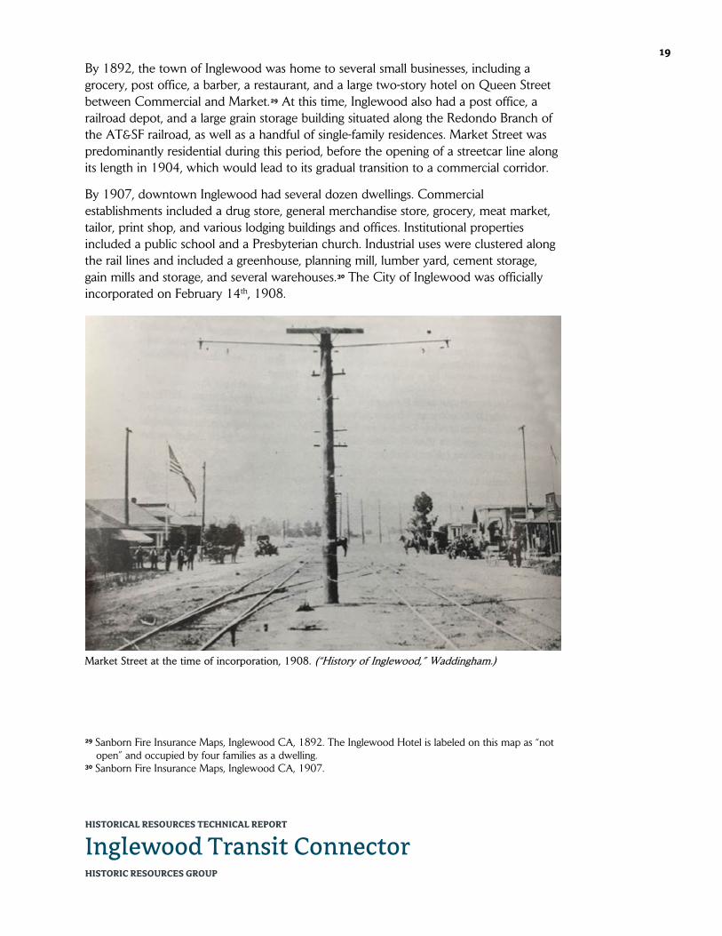
HISTORICAL RESOURCES TECHNICAL REPORT
Inglewood Transit Connector HISTORIC RESOURCES GROUP
19
By 1892, the town of Inglewood was home to several small businesses, including a grocery, post office, a barber, a restaurant, and a large two-story hotel on Queen Street between Commercial and Market.29 At this time, Inglewood also had a post office, a railroad depot, and a large grain storage building situated along the Redondo Branch of the AT&SF railroad, as well as a handful of single-family residences. Market Street was predominantly residential during this period, before the opening of a streetcar line along its length in 1904, which would lead to its gradual transition to a commercial corridor.
By 1907, downtown Inglewood had several dozen dwellings. Commercial establishments included a drug store, general merchandise store, grocery, meat market, tailor, print shop, and various lodging buildings and offices. Institutional properties included a public school and a Presbyterian church. Industrial uses were clustered along the rail lines and included a greenhouse, planning mill, lumber yard, cement storage, gain mills and storage, and several warehouses.30 The City of Inglewood was officially incorporated on February 14th, 1908.
29 Sanborn Fire Insurance Maps, Inglewood CA, 1892. The Inglewood Hotel is labeled on this map as “not
open” and occupied by four families as a dwelling. 30 Sanborn Fire Insurance Maps, Inglewood CA, 1907.
Market Street at the time of incorporation, 1908. (“History of Inglewood,” Waddingham.)

HISTORICAL RESOURCES TECHNICAL REPORT
Inglewood Transit Connector HISTORIC RESOURCES GROUP
20
City of Inglewood
Also, by this time, Inglewood was home to an expansive cemetery. In 1905, a group of local businessmen formed the Inglewood Park Cemetery Association, acquiring a large plot of land just east of what would become downtown Inglewood. A total of 32 internments took place in the cemetery’s first year of operation, with funerals often arriving by rail from Los Angeles in a private funeral car.31 In 1907, the cemetery erected the Romanesque-style Grace Chapel, a three-quarters replica of a church in Edinburgh, Scotland. Within a decade, the cemetery would erect the Neoclassical-style Inglewood Mausoleum, the first community mausoleum in the State of California.32
Many of the South Bay region’s earliest settlers have been laid to rest at Inglewood Park Cemetery, including a number of Civil War veterans.33 Other notable residents include former Los Angeles Mayor Tom Bradley, Chet Baker, Ray Charles, Ella Fitzgerald, Etta James, boxer Sugar Ray Robinson, and architect Paul Williams.34
By 1912, Inglewood’s commercial core was beginning to take shape along Commercial Street between Los Angeles Street/Inglewood Avenue (now Florence Avenue) and Queen Street. Deep, narrow lots were being developed with various commercial uses, from restaurants and boarding houses, to plumbers and hardware stores. Market Street remained primarily residential during this period, with a few commercial buildings, including a jeweler, a milliner, a confectioner, an undertaker, a bank, and a Methodist church.35
By 1920, the South Bay’s local economy was booming due to the region’s fertile agricultural lands, productive oil fields, and emerging aviation industry. The City of Inglewood was growing exponentially, as hundreds of new homes were being built. At the same time, the city’s commercial development was coalescing into a downtown business district. Commercial Street between Regent and Queen streets was now solidly 31 Portions of the original railroad waiting station have been incorporated into the main entrance. 32 The Inglewood Mausoleum was erected over the course of three years, from 1913 to 1915. 33 Inglewood Park Cemetery, http://www.inglewoodparkcemetery.com/heritage.html (accessed February
2019). 34 Mike Sonksen, “On Location: Inglewood,” KCET: History and Society, https://www.kcet.org/history-
society/on-location-inglewood (accessed February 2019). 35 Sanborn Fire Insurance Maps, Inglewood CA, 1912.
Inglewood Park Cemetery, date unknown. (Inglewood Park Cemetery)

HISTORICAL RESOURCES TECHNICAL REPORT
Inglewood Transit Connector HISTORIC RESOURCES GROUP
21
commercial, boasting many of the business enterprises needed by any growing town, from banks and automobile showrooms, to furniture stores and a movie theater. South of Queen, Commercial Street was still largely undeveloped but for a few single-family residences and an apartment house. At this point, Market Street was more sparsely developed overall and displayed a combination of commercial and residential uses.36
The commercial structures erected in downtown Inglewood at this time were typical of those being built in downtowns throughout Southern California. These were what have since been termed “taxpayer blocks,” speculative investments to generate tax benefit until more valuable development could be carried out. Early examples were multi-unit two-story buildings, frequently with retail units on the ground floor and offices or apartments
above. These buildings were typically unreinforced brick in construction, with applied ornament of cast stone or terra cotta at the entrance or along the parapet. Depending on the size of the building, it may contain one or more retail storefronts, with flexible interiors to accommodate the ever-changing needs of individual tenants. While many of these buildings were vernacular in design, in Southern California they were often overlaid with details of the Spanish Colonial Revival style, including tile roofs or parapet edges, arched doors and window openings, and decorative wall tile and cast-stone detailing. With the advent of the personal automobile, a single-story version of the form became popular, with surface parking behind.37
Inglewood also had a number of churches by this time, including the First Methodist Episcopal Church, St. John’s Catholic Church, Church of the Brethren, and Christian Church.38 The only church that survives from this period is Holy Faith Episcopal Church, located at the southeast corner of Locust Street and Grace Avenue.39 The church was first established in 1911, with services held in the Inglewood Masonic Hall. In 1912, Grace Freeman Howland40 and her husband Charles donated the funds to
36 Sanborn Fire Insurance Maps, Inglewood CA, 1923. 37 Lauren Weiss Bricker, Marion Mitchell-Wilson, and Janet L. Tearnen, Inglewood Downtown District Main
Street Project Area, Historic Design Guidelines, report (Inglewood, CA: Main Street Inglewood, 2000), 9-10.
38 Bricker, 9. 39 Holy Faith Episcopal Church is located at 260 N. Locust Street. 40 Grace Freeman was the daughter of Daniel Freeman, considered the founder of the City of Inglewood.
Holy Faith Episcopal Church and Rectory, c. 1915. (James H. Osborne Photo Collection, CSUDH Archives)

HISTORICAL RESOURCES TECHNICAL REPORT
Inglewood Transit Connector HISTORIC RESOURCES GROUP
22
erect a religious complex consisting of a church, a rectory (the dwelling to the south), and parish hall (now a school at the rear). They hired a young architect, Philip Frohman, to design what would be hailed as “the most perfect example of true Gothic architecture in the West.” Frohman would go on to become nationally renowned, particularly for his work on the National Cathedral in Washington, D.C. The church was officially consecrated on November 8th, 1914, and dedicated to Catherine Freeman and Mathilda Howland, the mothers of Grace and Charles. The church lost its original bell tower in the 1933 Long Beach Earthquake, but soon thereafter gained the Stations of the Cross, imported from Italy; the pulpit, lectern and choir stalls from England; and the reredos carved and imported from Bavaria. The stained-glass windows were crafted by Judson Studios in Highland Park.41
On the evening of June 21st, 1920, the Los Angeles Basin was rattled by an estimated 5.0 earthquake centered near Inglewood. While tremors were felt as far away as Ventura and Riverside, almost all of the damage took place in Inglewood, and specifically to the unreinforced brick buildings along Commercial Street (now La Brea Avenue),
where exterior walls fell into the street and plate glass windows shattered.42 The Inglewood Hotel was also badly damaged and subsequently demolished. Despite the widespread damage, however, the earthquake did not seriously hamper the city’s growth. In fact, according to local historian Gladys Waddingham, the quake appears to have been a boon to development, as “many of the people who flocked to see the damage were seeing Inglewood for the first time and were so impressed that they came back to live.” This hypothesis is borne out by population figures: the 1920 census credited Inglewood with a population of 3,286. In just two years the figure would double, making Inglewood the fastest growing city in the nation.43
The 1920s was a boom period for the City of Inglewood, both in terms of population and development. While Commercial Street continued to be the primary artery of the
41 “Holy Faith Episcopal Church: One Hundred Years of Ministry,” Holy Faith Episcopal Church,
https://www.holyfaithla.org/ (accessed February 2019). 42 Paul R. Spitzzeri, “Shake, Rattle and Roll: The Inglewood Earthquake of 21 June 1920,” Homestead
Museum, https://homesteadmuseum.wordpress.com/2018/06/21/shake-rattle-and-roll-the-inglewood-earthquake-of-21-june-1920/ (accessed February 2019).
43 Waddingham, 26.
Damaged buildings from Inglewood Earthquake, June 21, 1920. (California Historical Society Collection, USC)

HISTORICAL RESOURCES TECHNICAL REPORT
Inglewood Transit Connector HISTORIC RESOURCES GROUP
23
downtown business district, many more businesses were being established on Market Street and its cross-streets during this period. At least seven new buildings were constructed in the 100 block of North Market Street alone. The local financial institution the People’s Federal Building & Loan Association was established at this time, first in a unit of the building at 314 S. Market Street, before constructed their own building at the northeast corner of Market Street and Pimiento Street (now Manchester Boulevard) in 1927.44 That same year, the Bank of Inglewood erected a two-story mixed-use building at the northeast corner of Market and Queen streets, at a cost of $140,000. Designed by local architect William L. Campbell in the Mediterranean Revival style, the reinforced concrete building was touted as the “first steel frame business block in this city” and as “practically fire and earthquake proof.”45
On May 18th, 1927, some 15,000 locals came out to celebrate the “Festival of Light” which marked the opening of a new ornamental lighting system installed along Market Street. In addition to providing much needed illumination, the standards also supported the trolley wires of the Los Angeles Railway, allowing for the removal of the wooden poles from the middle of the street and the sidewalk. 46 In 1928, a two-story mixed-use structure called the Professional Building was constructed at Market Street and Manchester Boulevard’s northwest corner. The building was designed in the Spanish Colonial Revival style with Churrigueresque details.47 Also constructed in downtown Inglewood during this period were a new City Hall building (1923, demolished), the 44 The former People’s Federal Building & Loan Association building is located at 150 S. Market Street. It is
currently occupied by the World Hat & Boot Mart. 45 “Two-Story Business Structure: Work for Inglewood Bank Let,” Los Angeles Times, May 15, 1927. The
former Bank of Inglewood building is located at 100 N. Market Street/307 E. Queen Street. 46 “Inglewood Glows Under New Lights,” Los Angeles Times, May 20, 1927. 47 The Professional Building is located at 149-155 S. Market Street/231-239 E. Manchester Boulevard.
Market Street, looking north, 1925. (Security Pacific National Bank Collection, LAPL)

HISTORICAL RESOURCES TECHNICAL REPORT
Inglewood Transit Connector HISTORIC RESOURCES GROUP
24
Granada Theater (1923, demolished), an S.H. Kress Variety Store (1927), and a United Artists Theater (1931, demolished), as well as a number of auto-related businesses such as gas stations and repair garages.
Toward the end of the 1930s, Inglewood’s economic base began to expand outside the downtown core. Appropriately, in 1937 Commercial Street was officially changed to La Brea Avenue, connecting it with the street in Los Angeles.48 Also that year, Mines Field, which had been established just southwest of the city, was purchased by the City of Los Angeles to serve as its municipal airport, bringing many new jobs to the region. In 1938, the Hollywood Park, an “ultra-modern” thoroughbred racetrack, opened on 314 acres just southeast of downtown, effectively making Inglewood a destination for the first time.49 In addition to attracting the typical racing fan, Hollywood Park brought in celebrated personalities associated with the entertainment industry—from studio executives Jack Warner, Walt Disney and Samuel Goldwyn, to A-list actors like Al Jolson and Bing Crosby—many of whom were also investors in the operation.
Wartime and Postwar Growth
As war clouds gathered in the early 1940s, a number of aviation-related and other wartime manufacturing facilities set up shop around the Los Angeles Airport. North American Aviation, Inc. and the Northrup Company both established airplane manufacturing plants in the vicinity. Due to the emergence of these new facilities, this area would not only be critical to the defense industry during World War II, but in the
postwar years would evolve into one of the most important centers of the nation’s aerospace industry.
The presence of wartime and postwar manufacturing jobs added sharply to the local population and financially supported a growing middle class throughout the South Bay region, including in Inglewood. In 1938, the city had a population of 26,000; by 1956, that number had grown to 64,000.50 Housing construction naturally responded to the increased demand, and commercial development followed, leading to a pattern of postwar decentralization. By the mid-1950s, the city had three retail business areas—in North Inglewood, Morningside Park, and Crenshaw—in addition to the downtown.
48 Waddingham, 43. 49 Bricker, 15. 50 Ibid.
Fox Theater, early 1950s. (John Chappell Collection, Cinema Treasures)

HISTORICAL RESOURCES TECHNICAL REPORT
Inglewood Transit Connector HISTORIC RESOURCES GROUP
25
Despite this tremendous growth overall, new development in downtown Inglewood was very limited during this period. In 1941 a J.C. Penney department store opened on Market Street between Queen Street and Manchester Boulevard. Originally constructed as a one-story building, in 1954 it was expanded with a second story and remodeled in its exiting Mid-Century Modern style, with a deep front canopy and glazed terra cotta tile columns.51
The Fox Theater opened on March 31st, 1949, on Market Street between Regent and Queen. Erected on the site of the Granada Theater, which burned down in 1945, it was the last theater constructed by the Fox West Coast Theater chain. Designed by prolific theater architect S. Charles Lee in the Late Moderne style, it was the first theater in Inglewood to have air conditioning. Other features included automatic lobby doors, CinemaScope widescreen projections, assistance for the hearing impaired, and a soundproof “crying room.” The Fox Inglewood was often used for Fox Pictures’ premiers and sneak previews.52
During this same period, two substantial institutions opened just outside of downtown Inglewood. In 1948, Bank of America erected a sprawling 22,000-square-foot branch at the southwest corner of Manchester Boulevard and Locust Street.53 That same year, funeral director John Flanagan opened Hardin & Flanagan Colonial Chapel & Mortuary on Prairie Avenue at La Palma Drive, across the street from Hollywood Park. Flanagan built a number of
mortuaries around the Los Angeles area using the same American Colonial Revival design. In 1959, the business was purchased by the McCormick family and renamed McCormick Mortuary.54 The following year, the building was expanded with a two-story north wing, adding a new lobby with offices above. Today, the business is operated as Lighthouse McCormick Mortuary.55 The other area for new development during the
51 The former J.C. Penney building is located at 129-139 S. Market Street. 52 “Inglewood Fox Theatre,” Los Angeles Historic Theatre Foundation, http://www.lahtf.org/inglewoodfox/
(accessed February 2019); “Fox Theater,” Inglewood Public Art, http://www.inglewoodpublicart.org/ Fox_Theater.html (accessed February 2019). The former Fox Theater is located at 115 N. Market Street.
53 The Bank of America building is located at 320-330 E. Manchester Boulevard. 54 The McCormick family operated various locations throughout the South Bay, including Westchester,
Hawthorne, Redondo Beach, Manhattan Beach, Gardena, and Whittier. 55 The Lighthouse McCormick Mortuary is located at 619-635 S. Prairie Avenue.
Hardin & Flanagan Colonial Chapel and Mortuary (now Lighthouse McCormick Mortuary), c. 1950. (Tichnor Brothers Collection, Boston Public Library)

HISTORICAL RESOURCES TECHNICAL REPORT
Inglewood Transit Connector HISTORIC RESOURCES GROUP
26
postwar period was La Brea Avenue, a wide auto corridor which previously served as the western border of downtown Inglewood.56
Despite these examples of new construction in and around downtown during this period, the primacy of the city’s downtown as a commercial district was substantially diminished by increased competition from outlying commercial areas. The removal of the Market Street trolley line in 1957 added further stress to already struggling businesses. The city responded by adding municipally-owned off-street parking lots located throughout the district to draw car-dependent shoppers. The Chamber of Commerce and Downtown Inglewood Retail Merchants Association coordinated to organize various promotional activities, as well as physical improvements like tree planting in the center strip and along sidewalks, which were in place by the early 1960s.57 However, these effects of these efforts were soon eclipsed by the continued loss of customers to new shopping malls in communities throughout Los Angeles. Inglewood considered, but ultimately rejected plants to build a mall of its own on a large parcel at Prairie and Manchester, a proposal largely defeated by the Market Street merchants. The site would instead become the home of the Forum.58
By the late 1960s, downtown Inglewood was in need of reinvention. To this end, the city contemplated a wholesale redevelopment scheme for the Market Street corridor
56 Also built during this period was a Sears department store at Manchester and Hillcrest boulevards.
Opened in 1947, this was an early indicator that the future of retail in Inglewood would not be downtown. Sears was demolished in 1993 and replaced by a Vons supermarket.
57 “Downtown Center of Many Activities,” Los Angeles Times, March 18, 1962. 58 “The Changing Face of South Bay: Downtowns,” Los Angeles Times, January 4, 1987.
Market Street, looking north from Queen Street, 1955. (Alan Weeks, L.A. County Metropolitan Transportation Authority Library & Archive)

HISTORICAL RESOURCES TECHNICAL REPORT
Inglewood Transit Connector HISTORIC RESOURCES GROUP
27
that would expand and remodel existing stores, construct two high-rise office and apartment towers, introduce a landscaped arcade, and build a four-square block parking deck above shops to quadruple parking capacity.59 However, this plan would go unrealized. The United Bank of California at the southeast corner of Market and Regent streets would be the first new structure to be added to the Market Street corridor in nearly two decades, replacing several early 20th-century commercial buildings.60 Constructed in 1967 in the Late Modern style, it was joined nine years later by a stand-alone drive-thru automated teller building situated across Regent from the bank. Both buildings are believed to have been designed by Los Angeles modernist Richard Dorman.61
Beyond Downtown
In the late 1960s, nationally prominent businessman Jack Kent Cooke selected the site of a former golf course at the southeast corner of Prairie Avenue and Manchester Boulevard to erect a new venue for his three professional sports franchises: the Los Angeles Lakers NBA basketball team, the Los Angeles Kings NHL hockey team, and the short-lived Los Angeles Wolves professional soccer team. The Forum, a multi-purpose indoor arena, was designed by the prominent Los Angeles architectural firm Charles
59 “$11 Million Center Assured in Inglewood,” Los Angeles Times, March 31, 1968. 60 The former United Bank of California is located at 158-170 N. Market Street. 61 Although an original building permit for the 1967 bank building is not available from the City of
Inglewood, the permit for the similarly-styled drive-thru automated teller building lists Richard Dorman as its architect.
Market Street, looking south from Regent Street, 1961. (Inglewood Public Library, Online Archive of California)

HISTORICAL RESOURCES TECHNICAL REPORT
Inglewood Transit Connector HISTORIC RESOURCES GROUP
28
Luckman & Associates and completed in 1967.62 Designed in the New Formalist architectural style, it was intended as a modern and highly-stylized version of the Coliseum of ancient Rome. Nicknamed “the Fabulous Forum,” it would host tennis matches, boxing matches, ice shows, rodeos, the circus, award shows, and political events. In 1972, the Forum was the site of the Lakers’ first NBA championship since moving to Los Angeles; five additional titles would follow in the 1980s. From the mid-1970s through the 1990s, the Forum would serve as the premier large-scale concert venue for the Los Angeles area, and would be influential in the birth of “arena rock.” During the 1984 Olympics, the Forum was the venue for men’s and women’s basketball.63
By the early 1970s, Market Street had turned into a virtual ghost town as shoppers abandoned the downtown business center for suburban malls, and key tenants like J.C. Penney closed their doors. In an effort to reinvigorate the core of the city, from 1971 to 1976 Inglewood spent about $50 million in local, county, and federal funds to erect a new civic center complex along La Brea Avenue, just one block west of downtown. This new complex combined City Hall, a courthouse, library, fire and police facilities, public health complex, and a major new parking garage onto a single super-block, surrounded by expanses of lawn and public art. As hoped, this new construction sparked a flurry of new commercial development in the larger In-Town Redevelopment Area64—bounded by Florence, Locust, Manchester and Fir—the vast majority of which was office space and not retail. Several residential projects were built at this time as well, most notably the 200-unit Inglewood Meadows housing complex on Locust Street, just east of downtown.65
While these projects brought large numbers of people into the vicinity of Market Street, their presence did not raise the corridor’s fortunes, and the vitality of the downtown business district continued to wain into the 1980s. In October 1986, Market Street
62 The Forum is located at 3900 W. Manchester Boulevard. 63 “Forum,” National Register of Historic Places Form. Prepared by Historic Resources Group, April 29,
2014. 64 The In-Town Redevelopment Area was one of six redevelopment project areas adopted by the
Inglewood Redevelopment Agency between 1970 and 1973. 65 Dean Murphy and Michele L. Norris, “Government Money Becomes Urban Lifeblood: Innovation and
Optimism Thrive on Public Funds in Inglewood, San Pedro,” Los Angeles Times, January 4, 1987.
The Forum under construction, with Jack Kent Cooke and Charles Luckman, 1967. (Herald Examiner Collection, LAPL)
HISTORICAL RESOURCES TECHNICAL REPORT
Inglewood Transit Connector HISTORIC RESOURCES GROUP
29
merchants brought downtown business activity to halt as they closed their shops and picketed in a city-owned parking lot in a last-ditch effort to save it from redevelopment. The parking lot at La Brea Avenue and Queen Street provided 80 metered parking spaces which local shopkeepers saw as critical to continued viability of the downtown business district, which was already suffering from a severe parking shortage. Ultimately, however, the protests were unsuccessful, and the parking lot was soon replaced by a five-story office building.66 Yet another sign of downtown’s economic decline, the Fox Theater, then owned by the Mann theater chain, closed its doors in 1988.
Since the late-1970s, at least four City-sponsored revitalization programs have focused on improving Market Street’s commercial viability, introducing street landscaping and furniture as well as façade improvements to the existing buildings. Efforts have included a façade improvement program designed by architectural firm Kahn, Kappe, Lotery, Boccato (1979); a $250,000 façade improvement program, including signs and awnings (1984); a California Main Street Community Project (1990s); and the Market Street Renaissance program (2000). However, despite these efforts, Market Street has largely remained an underutilized asset.
Inglewood Today & Tomorrow
In 1994, Hollywood Park underwent a $100 million expansion into Hollywood Park Casino, which extended the facility’s economic viability. However, in May of 2013, it was announced that the Hollywood Park racetrack would be closing at the end of the fall racing season. In 2015, the Inglewood City Council approved a plan to build an 70,000-seat football stadium on the site in anticipation of the St. Louis Rams moving back to Los Angeles. The Inglewood mayor was on-hand to witness the demolition by explosives of the massive grandstand.
The Forum remained the home of the Lakers and Kings until 1999, when both teams relocated to the newly-constructed Staples Center in downtown Los Angeles. Beginning in 2012, the Forum underwent a $50 million renovation, reopening in 2014. Later that year, the Forum was listed in the National Register of Historic Places. The venue is inextricably tied to the identity of the City of Inglewood, which adopted the moniker “City of Champions.” The Forum is slated to host the gymnastics events for the 2028 Summer Olympics.
Over the past decade, the City of Inglewood has been acquiring select parcels throughout the city for redevelopment, including along Market Street. Various planning studies have been conducted to develop standards for transit-oriented development, mixed-use development, and parking, with the goal of revitalizing downtown Inglewood. Local advocacy organization the Inglewood Historic Preservation Alliance (IHPA, formerly the Inglewood Historic Site Preservation Committee) continues to work
66 “Merchants Protest Proposal to Build on Parking Lot,” Los Angeles Times, October 16, 1986.

HISTORICAL RESOURCES TECHNICAL REPORT
Inglewood Transit Connector HISTORIC RESOURCES GROUP
30
toward the protection of the city’s historic structures and places of interest, including the Fox Theatre, which was successfully listed in the National Register of Historic Places in 2013.67 Currently, the City of Inglewood is utilizing The New Downtown and Fairview Heights Transit Oriented Development Plan and Design Guidelines, adopted November 1st, 2016, as the controlling document for future activity along Market Street.
On January 12th, 2016, the NFL voted to move the St. Louis Rams back to Los Angeles, with the San Diego Chargers to follow. In October 2016, the last part of the former racetrack, the Casino, was demolished and a new Hollywood Park Casino was opened next door. The new Los Angeles Stadium at Hollywood Park is currently under construction. When completed in 2020, it will be the new home of the NFL’s Los Angeles Rams and Los Angeles Chargers. The Los Angeles Stadium is slated to host Super Bowl LVI in 2022, the College Football National Championship in 2023, and the opening and closing ceremonies and soccer events for the 2028 Summer Olympics.
67 Anne Cheeck La Rose, “Inglewood Fox Theatre: Bringing Back the Inglewood Fox Theatre,” Los Angeles
Historic Theatre Foundation, http://www.lahtf.org/inglewoodfox/ (accessed February 2019).

HISTORICAL RESOURCES TECHNICAL REPORT
Inglewood Transit Connector HISTORIC RESOURCES GROUP
31
5.2 Selected Chronology
Pre-History
3,500 BP
The Tongva occupy the area now encompassed by the Los Angeles basin, San Fernando Valley, San Gabriel Valley, San Bernardino Valley, and the local California coastline.
Spanish Colonial Period
1542 Spanish explorer Juan Rodriguez Cabrillo makes the first documented European contact with the native Tongva people.
1769 The Portolá expedition passes through present-day downtown Los Angeles, encountering the native people from the village of Yang-na.
1771 On September 8th, Spanish colonists establish Mission San Gabriel, the fourth of California’s Spanish missions.
1778 El Pueblo de Los Angeles is officially founded under the Spanish Laws of the Indies on September 4th.
Mexican Period
1821 Mexico wins its independence from Spain and Alta California becomes a territory of the new Mexican Republic.
1834 The California Missions are secularized by the Mexican government, and mission lands are confiscated for distribution in large land grants called ranchos.
Ygnacio Machado builds the Centinela Adobe, now considered the “birthplace of Inglewood.”
1837 The Machado family is granted official title of the area around Centinela Springs as the 2,219-acre Rancho Aguaje de la Centinela.
The Ávila family is granted the 22,458-acre Rancho Sausal Redondo, encompassing much of what is now the South Bay region of Los Angeles County.
1845 Bruno Ygnacio Ávila acquires Rancho Aguaje de la Centinela from the Machados in exchange for a small tract in the Pueblo de Los Ángeles for.
American Period
1846 United States troops begin occupying Alta California.
1848 The signing of the Treaty of Guadalupe Hidalgo on February 2nd cedes the California territory to the United States and ends the Mexican-American War.
1850 Los Angeles incorporates as an American city on April 4th.
California is admitted to the Union as its 31st state.

HISTORICAL RESOURCES TECHNICAL REPORT
Inglewood Transit Connector HISTORIC RESOURCES GROUP
32 1857 Bruno Ávila loses Rancho Aguaje de la Centinela through foreclosure.
1860 Rancho Aguaje de la Centinela is acquired by Scotsman Sir Robert Burnett.
1868 The heirs of Antonio Ávila are forced to sell Rancho Sausal Redondo to pay probate costs.
1872 Burnett acquires Rancho Sausal Redondo, combining his total land holdings of some 25,000 acres into the Centinela Ranch, encompassing the present-day communities of Playa del Rey, El Segundo, Manhattan Beach, Hermosa Beach, Redondo Beach, Westchester, Inglewood, Hawthorne, and Lawndale.
1873 Burnett leases his property to Daniel and Catherine Freeman.
1885 Daniel Freeman officially acquires Burnett’s property and names it Inglewood.
1887 Freeman sells some 11,000 acres of his ranch to the Centinela-Inglewood Land Company for development.
Inglewood Townsite
1888 The townsite of Inglewood is platted by the Centinela-Inglewood Land Company.
The California Central Railway completes a line to Redondo Beach.
Freeman erects a large mansion in Inglewood.
1889 Freeman builds a land office on the grounds of the Centinela Adobe.
1905 A group of local businessmen forms the Inglewood Park Cemetery Association.
1907 The Romanesque-style Grace Chapel is erected at Inglewood Park Cemetery.
City of Inglewood
1908 The City of Inglewood is incorporated on February 14th.
1914 Holy Faith Episcopal Church, designed by nationally renowned architect Philip Frohman, is officially consecrated.
1915 The Neoclassical-style Inglewood Mausoleum at the Inglewood Park Cemetery is completed.
1920 On the evening of June 21st, the Los Angeles Basin is rattled by an estimated 5.0 earthquake centered near Inglewood.
1927 The People’s Federal Building & Loan Association erects a building at the northeast corner of Market Street and Manchester Boulevard.
The Bank of Inglewood building is erected at the northeast corner of Market and Queen streets.

HISTORICAL RESOURCES TECHNICAL REPORT
Inglewood Transit Connector HISTORIC RESOURCES GROUP
33 A new ornamental lighting system is installed along Market Street.
1928 The Professional Building is constructed at Market Street and Manchester Boulevard’s northwest corner.
1929 The stock market crashes in late October, ultimately leading to the Great Depression.
1933 On the evening of March 10th, a magnitude 6.4 earthquake strikes off the coast of Long Beach.
1937 Mines Field, west of Inglewood, is purchased by the City of Los Angeles to serve as its municipal airport.
1938 Hollywood Park thoroughbred racetrack opens just southeast of downtown Inglewood.
Wartime & Postwar Growth
1941 On December 7th, the U.S. naval base at Pearl Harbor is attacked by the Imperial Japanese Navy, leading to the United States’ entry into World War II.
A J.C. Penney department store opens in downtown Inglewood.
1945 The Granada Theater on Market Street burns down.
1947 Sears department store opens at Manchester and Hillcrest boulevards.
1948 Bank of America opens a large branch on Manchester Boulevard, just east of downtown Inglewood.
The Hardin & Flanagan Colonial Chapel and Mortuary (now Lighthouse McCormick Mortuary) opens on Prairie Avenue, across from Hollywood Park.
1949 On March 31st, the Fox Theater opens on Market Street on the site of the Granada Theater.
Los Angeles Airport is renamed Los Angeles International Airport.
Beyond Downtown
1957 The Market Street trolley line is removed.
1967 The United Bank of California becomes the first contemporary structure to be added to the Market Street corridor.
The Forum is built by prominent businessman Jack Kent Cooke as a venue for his three professional sports franchises in Los Angeles: the Lakers (basketball), Kings (hockey), and Wolves (soccer).
1972 The Forum is the site of the Lakers’ first NBA championship since moving to Los Angeles.

HISTORICAL RESOURCES TECHNICAL REPORT
Inglewood Transit Connector HISTORIC RESOURCES GROUP
34 1973 A new Inglewood Civic Center complex is constructed just west of downtown.
1984 The Forum is the venue for men’s and women’s basketball during the Summer Olympics.
1986 Market Street merchants picket to stop the loss of a parking lot at La Brea Avenue and Queen Street for new construction; the protest is unsuccessful.
1988 The Fox Theater, then owned by the Mann theater chain, closes its doors.
Inglewood Today & Tomorrow
1993 Sears is demolished and replaced by a Vons supermarket.
1994 Hollywood Park undergoes a $100 million expansion into Hollywood Park Casino.
1999 The Lakers and Kings leave the Forum for the newly-constructed Staples Center in downtown Los Angeles.
2013 It is announced that Hollywood Park racetrack will close at the end of the fall racing season.
The Fox Theatre is listed in the National Register of Historic Places.
2014 The Forum reopens after a $50 million renovation.
The Forum is listed in the National Register of Historic Places.
2015 The Inglewood City Council approves a plan to build an 70,000-seat football stadium on the Hollywood Park site.
2016 On January 12th, the NFL votes to move the St. Louis Rams back to Los Angeles, with the San Diego Chargers to follow.
The Hollywood Park casino is demolished, and a new casino opened next door.
2020 The Los Angeles Stadium at Hollywood Park (SoFi Stadium) opens as the new home of the NFL’s Los Angeles Rams and Los Angeles Chargers.
2022 Los Angeles Stadium is scheduled to host Super Bowl LVI.
2023 Los Angeles Stadium will be the venue for the College Football National Championship.
2028 Los Angeles Stadium will host the opening and closing ceremonies for the Summer Olympics, as well as soccer events.
The Forum is slated to host the gymnastics events for the Summer Olympics.
HISTORICAL RESOURCES TECHNICAL REPORT
Inglewood Transit Connector HISTORIC RESOURCES GROUP
35 6.0 IDENTIFICATION OF HISTORICAL RESOURCES
6.1 Listed Historical Resources There are two (2) properties within the Project Area and/or Expanded Study Area that are listed in the National Register, and are therefore automatically listed in the California Register. As such, these properties are considered historical resources as defined by CEQA.
3900 W. Manchester Boulevard (The Forum)
This property, located at the southeast corner of Manchester Boulevard and Prairie Avenue, contains the Forum, a multi-purpose indoor arena, surrounded by an expansive surface parking lot. It was built by nationally prominent businessman Jack Kent Cooke as a venue for his three professional sports franchises: the Los Angeles Lakers NBA basketball team, the Los Angeles Kings NHL hockey team, and the short-lived Los Angeles Wolves professional soccer team. Completed in 1967, it was designed by prominent Los Angeles architectural firm Charles Luckman & Associates in the New Formalist style. From 2012 to 2014, it underwent an extensive historic renovation.
The Forum was listed in the National Register of Historic Places on September 24th, 2014 under Criterion C as an excellent example of a 1960s New Formalist-style arena building,68 and is therefore automatically listed in the California Register. As such, this property is a historical resource under CEQA.
115 N. Market Street (former Fox Theater)
This property, located on the west side of Market Street between Regent and Queen streets, contains a 12,090 sq. ft. neighborhood movie theater building. Originally constructed in 1949 for Fox West Coast Theaters, it was designed by prolific theater architect S. Charles Lee in the Late Moderne style. The building is currently unoccupied and its storefront windows and doors are boarded up.
In 2000, the property was assigned a status code of 3S (appears eligible for the National Register as an individual property through survey evaluation) under Criterion C as a very good example of a 1940s Late Moderne-style movie theater building in Inglewood.69 On January 14th, 2013, the Fox Theater was listed in the National Register of Historic Places, and is therefore automatically listed in the California Register.70 As such, this property is a historical resource under CEQA.
68 “Forum,” National Register of Historic Places Registration Form, prepared by Historic Resources Group,
April 29, 2014. 69 Bricker. 70 “Fox Theatre Inglewood,” National Register of Historic Places Registration Form, prepared by Brian
Curran, Jr. (accessed February 2019).

HISTORICAL RESOURCES TECHNICAL REPORT
Inglewood Transit Connector HISTORIC RESOURCES GROUP
36
6.2 Previously Identified Historical Resources There are nine (9) properties within the Project Area and/or Expanded Study Area that have been previously identified as eligible for historic listing or designation through historic resources surveys, environmental review, or other efforts. Most notably, a previous historical resources survey of Market Street was conducted as part of the Inglewood Downtown District/Main Street Project Area Historic Design Guidelines project, completed by Lauren Weiss Bricker, PhD, Marion Mitchell-Wilson, and Janet L. Tearnen in 2000.71 Each of these properties has been re-examined and re-evaluated for its eligibility for listing in the National Register or California Register.
Of these previously identified historical resources, four (4) were re-evaluated as appearing eligible for listing in the National Register and/or California Register, and are therefore considered herein as historical resources for the purposes of CEQA. Five (5) were found to appear ineligible for historic listing due to substantial alteration. No historic districts have been previously identified within the Project Area and/or Expanded Study Area.72
302 E. Manchester Boulevard/200-204 S. Market Street (Cox Menswear)
This property, located at the southeast corner of Manchester Boulevard and Market Street, contains a two-story commercial retail building. Originally constructed in 1941, the building was designed in the Streamline Moderne style and was historically occupied by Scotty’s Men’s Shop. The building’s current tenant is Cox Menswear. In 2000, the property was assigned a status code of 3S (appears eligible for the National Register as an individual property through survey evaluation) under Criterion C as a good example of the Streamline Moderne style in Inglewood.73
Historic Resources Group has re-examined this property for the purpose of this report, and finds that it appears to have been substantially altered over time. On the ground story, the existing stone veneer and projecting aluminum-frame display windows appear to be the result of a mid-century remodel, replacing all of the original retail storefronts and wall cladding along both street-facing façades. On the upper story, original fenestration has been replaced with vinyl sliders. Also, the neon sign that originally adorned the corner tower has been removed. Due to these alterations, the building no
71 This 2000 report included a historic resources survey of the Inglewood Downtown District/Main Street
project area, which was bounded by La Brea Avenue to the west, Locust Street to the east, Florence Avenue to the north, and Hillcrest Boulevard to the south. The upper portion of this survey area includes the Market Street portion of the current Project Area/Expanded Study Area. The survey identified eight (8) individual properties within the current Project Area/Expanded Study Area as eligible for historic designation; no historic district was identified.
72 The New Downtown and Fairview Heights Transit Oriented Development Plan and Design Guidelines, adopted November 1, 2016, identifies Downtown Inglewood as “Historic Downtown.” However, this appears to refer to the area’s history as Inglewood’s original business district, and is not an evaluation of historic eligibility.
73 Bricker.

HISTORICAL RESOURCES TECHNICAL REPORT
Inglewood Transit Connector HISTORIC RESOURCES GROUP
37
longer displays the characteristic features of the Streamline Moderne style, nor does it represent a comprehensive or wholesale stylistic remodel from a particular historic period. Thus, this building does not retain sufficient integrity to convey its significance as a good example of its architectural style, and therefore does not appear eligible for listing in the National Register or the California Register. As such, it is not considered a historical resource herein for the purposes of CEQA.
320-330 E. Manchester Boulevard (Bank of America)
This property, located at the southwest corner of Manchester Boulevard and Locust Street, contains a 21,976 sq. ft. bank building and a rear surface parking lot.74 Originally constructed in 1948, the building was erected for Bank of America and designed in the Late Moderne style. Bank of America continues as its current tenant. The smaller adjacent building at 320 E. Manchester Boulevard was originally constructed in 1920 and remodeled as part of the Bank of America in 1954. In 2000, the property was assigned a status code of 3S (appears eligible for the National Register as an individual property through survey evaluation) under Criterion C as a good example of a 1940s PWA Moderne-style bank building in Inglewood.75
Historic Resources Group has re-examined this property for the purpose of this report, and finds that it appears substantially unaltered since its original construction. The building retains the majority of its original exterior features, including its form and massing, exterior wall cladding, fenestration patterns, and decorative elements. The framing of the windows and doors may have been updated. However, the replacement material appears to be in keeping with what would have been in place historically, such that this change does not substantially diminish the building’s integrity. Other changes—including lighting, signage, and the addition (and subsequent removal) of an in-wall ATM—are minor in relation to the building’s overall appearance. The building remains largely intact and continues to display the characteristic features of a PWA Moderne bank building from the 1940s. Thus, this building retains sufficient integrity to convey its significance as a good example of its architectural style, and therefore appears eligible for listing in the California Register. As such, this property is considered a historical resource herein for the purposes of CEQA.
100 N. Market Street/307 E. Queen Street (former Bank of Inglewood)
This property, located at the northeast corner of Market and Queen streets, contains a two-story, 9,258 sq. ft. mixed-use commercial building constructed in 1927. The building was originally constructed for the Bank of Inglewood at a cost of $140,000. Designed by local architect William L. Campbell in the Mediterranean Revival style, the reinforced concrete building was the first steel frame business block in the city. The
74 The main bank building uses the address 330 E. Manchester Bl.; the smaller adjacent building is at 320. 75 Bricker.

HISTORICAL RESOURCES TECHNICAL REPORT
Inglewood Transit Connector HISTORIC RESOURCES GROUP
38
building was sold to Bank of America National Trust & Savings Association in 1936; in 1950 it became Southwest Bank. It now serves as a retail space occupied by Vajra Books & Gifts. In 2000, the property was assigned a status code of 3S (appears eligible for the National Register as an individual property through survey evaluation) under Criterion C as an excellent example of a 1920s Mediterranean Revival-style bank building in Inglewood.76
Historic Resources Group has re-examined this property for the purpose of this report, and finds that it appears substantially unaltered since its original construction. The building retains the majority of its original exterior features, including its form and massing, roof material, exterior wall cladding, fenestration patterns, elaborated arched main entrance and ground-story windows, upper-story windows, and various decorative elements. Alterations—such as replaced front doors and the addition of tile cladding on the ground story—are minor in relation to the building’s overall appearance, and do not substantially diminish its integrity. The building remains highly intact and continues to display the characteristic features of a Mediterranean Revival bank building from the 1920s. Thus, this building retains sufficient integrity to convey its significance as a good example of its architectural style, and therefore appears eligible for listing in the National Register and the California Register. As such, this property is considered a historical resource herein for the purposes of CEQA.
124-126 N. Market Street
This property, located on the east side of Market Street between Regent and Queen streets, contains a two-story, 2,750 sq. ft. mixed-use commercial building constructed in 1920. In 2000, the property was assigned a status code of 5S1 (eligible for local listing); no reason for significance was provided.77
Historic Resources Group has re-examined this property for the purpose of this report, and finds that it appears to have been substantially altered over time. The building’s original retail storefronts have been replaced with floor-to-ceiling aluminum storefronts, thereby completely altering the ground story on the building’s only publicly visible façade. On the upper story, original fenestration has been replaced with metal sliders. The building does not display the characteristic features of a particular architectural style and is not known to be the work of a master; it does not appear to be a notable example of its building type from a particular period; and it has no known important historic associations that would qualify it for historic listing or designation. Therefore, the building does not appear eligible for listing in the National Register or the California
76 Bricker. 77 Ibid. Note that Inglewood’s downtown survey was completed prior to the revision of the California
Historical Resources Status Codes. These codes were updated and their definitions revised in August 2003.

HISTORICAL RESOURCES TECHNICAL REPORT
Inglewood Transit Connector HISTORIC RESOURCES GROUP
39
Register. As such, it is not considered a historical resource herein for the purposes of CEQA.
125 S. Market Street
This property, located on the west side of Market Street between Queen Street and Manchester Boulevard, contains a one-story commercial building constructed in 1938. The building is currently occupied by Basket Beauty Supply. In 2000, the property was assigned a status code of 5S1 (eligible for local listing) under Criterion C as an intact example of a mid-century remodeled façade.78
Historic Resources Group has re-examined this property for the purpose of this report, and finds that it has been substantially altered over time, including since its previous evaluation. The 2000 survey referred to this building as “among the more visually interesting” mid-century façade remodels along Market Street, noting a “metal pylon sign [that] juts above the building's parapet at a sufficient height and angle to be seen by the pedestrian” and “framed [display] cases that cantilever beyond their built-in bases.”79 None of these features remain extant. Alterations include the replacement of the exterior wall cladding on both stories, the replacement of all retail storefronts and entry doors, the addition of applied decorative features above the canopy, added light fixtures, and contemporary signage. Taken together, these alterations have completely transformed the building’s only publicly visible façade, such that it no longer displays any elements of its original 1930s design, nor does it represent a comprehensive mid-century façade remodel. Thus, this building does not retain sufficient integrity to convey its significance as a good example of its architectural style, and therefore does not appear eligible for listing in the National Register or the California Register. As such, it is not considered a historical resource herein for the purposes of CEQA.
129-139 S. Market Street (former J.C. Penney)
This property, located on the west side of Market Street between Queen Street and Manchester Boulevard, contains a two-story, 62,583 sq. ft. commercial retail building which originally housed a J.C. Penney department store. The building was initially constructed as one story in 1941. In 1954, it was expanded with a second story and remodeled in the Mid-Century Modern style. It is currently occupied by Inglewood Marketplace. In 2000, the property was assigned a status code of 5S1 (eligible for local listing) under Criterion C as a good example of a 1950s Mid-Century Modern-style department store building.80
Historic Resources Group has re-examined this property for the purpose of this report, and finds that it appears substantially unaltered since its 1950s remodel. The building
78 Bricker. 79 Bricker, 16. 80 Bricker.
HISTORICAL RESOURCES TECHNICAL REPORT
Inglewood Transit Connector HISTORIC RESOURCES GROUP
40
retains the majority of its exterior features from this period, including its form and massing, exterior wall cladding, angled storefronts, recessed entry with terrazzo flooring, entry doors, canopy, upper-story ribbon windows, and applied decoration. Alterations—such as contemporary signage and the distinctive paint job—are minor in relation to the building’s overall appearance, and do not substantially diminish its integrity. The building remains highly intact and continues to display the characteristic features of a Mid-Century Modern department store building from the 1950s. Thus, this building retains sufficient integrity to convey its significance as a good example of its architectural style, and therefore appears eligible for listing in the California Register. As such, this property is considered a historical resource herein for the purposes of CEQA.
132 S. Market Street
This property, located on the east side of Market Street between Queen Street and Manchester Boulevard, contains a two-story mixed-use commercial building constructed in 1925. The building is currently occupied by Smoove Fashion World. In 2000, the property was assigned a status code of 5S1 (eligible for local listing); no reason for significance was provided.81
Historic Resources Group has re-examined this property for the purpose of this report, and finds that it appears to have been substantially altered over time. The building’s original retail storefront has been replaced with a floor-to-ceiling aluminum storefront, and brick veneer wall cladding and an awning have been added, thereby completely altering the building’s ground story. On the upper story, original fenestration has been replaced with metal or vinyl sliders. Some original decorative features remain on the upper story. However, overall the building does not display the characteristic features of a particular architectural style and is not known to be the work of a master; it does not appear to be a notable example of its building type from a particular period; and it has no known important historic associations that would qualify it for historic listing or designation. Therefore, the building does not appear eligible for listing in the National Register or the California Register. As such, it is not considered a historical resource herein for the purposes of CEQA.
150 S. Market Street (former People’s Federal Building & Loan Association)
This property, located at the northeast corner of Market Street and Manchester Boulevard, contains a two-story, 16,575 sq. ft. mixed-use commercial building. The building was originally constructed in 1927 as the People’s Federal Building & Loan Association. It was remodeled in the Late Modern style, likely sometime in the 1960s. It is currently occupied by World Hat & Boot Mart. In 2000, the property was assigned a
81 Bricker.

HISTORICAL RESOURCES TECHNICAL REPORT
Inglewood Transit Connector HISTORIC RESOURCES GROUP
41
status code of 5S1 (eligible for local listing) under Criterion C as a good example of a 1960s Late Modern-style commercial building.82
Historic Resources Group has re-examined this property for the purpose of this report, and finds that it appears substantially unaltered since its 1960s remodel. The building retains the majority of its exterior features from this period, including its form and massing, exaggerated arches and elevated roof plate, exterior wall cladding, metal storefronts and entry doors, canopy, and upper-story fenestration. Alterations—such as contemporary signage and the replacement of the original entry doors with a display window—are minor in relation to the building’s overall appearance, and do not substantially diminish its integrity. The building remains largely intact and continues to display the characteristic features of a Late Modern commercial building from the 1960s. Thus, this building retains sufficient integrity to convey its significance as a good example of its architectural style, and therefore appears eligible for listing in the California Register. As such, this property is considered a historical resource herein for the purposes of CEQA.
333 E. Nutwood Street
This property, located at the northwest corner of Locust and Nutwood streets, contains a one-story commercial office building constructed in 1940. The building is currently occupied by Anphon Medical Center. In 2000, the property was assigned a status code of 5S1 (eligible for local listing); no reason for significance was provided.83
Historic Resources Group has re-examined this property for the purpose of this report, and finds that it appears to have been substantially altered over time. The building’s exterior wall cladding has been replaced with rough-textured stucco, and exaggerated stucco-clad window surrounds have been added throughout. These changes are incompatible with the building’s American Colonial Revival style, and thereby substantially alter the building’s overall appearance. The building is no longer a good example of its architectural style and is not known to be the work of a master; it does not appear to be a notable example of its building type from a particular period; and it has no known important historic associations that would qualify it for historic listing or designation. Therefore, the building does not appear eligible for listing in the National Register or the California Register. As such, it is not considered a historical resource herein for the purposes of CEQA.
6.3 Newly Identified Historical Resources Detailed field surveys of the Project Area and Expanded Study Area were conducted on June 4th, 2018 and February 21st, 2019. These field surveys were supplemented by
82 Bricker. 83 Ibid.

HISTORICAL RESOURCES TECHNICAL REPORT
Inglewood Transit Connector HISTORIC RESOURCES GROUP
42
property-specific and contextual research to identify additional properties that are eligible for listing or designation and therefore may be considered historical resources under CEQA. Through this process, five (5) additional properties were evaluated as appearing eligible for listing in the National Register and/or California Register, and are therefore considered herein as historical resources for the purposes of CEQA. No historic districts were identified within the Project Area and/or Expanded Study Area.
260 N. Locust Street (Holy Faith Episcopal Church)
This property, located at the southeast corner of Locust Street and Grace Avenue, contains the Holy Faith Episcopal Church complex. The congregation was first established in 1911, with services held in the Inglewood Masonic Hall. In 1912, funds were donated to erect a complex consisting of a church, a rectory (the dwelling to the south), and parish hall (now a school at the rear). The complex of buildings was designed by architect Philip Frohman, would go on to become nationally renowned, particularly for his work on the National Cathedral in Washington, D.C. The church building was officially consecrated on November 8th, 1914. It lost its original bell tower in the 1933 Long Beach Earthquake, but continued to be improved throughout the 1930s, with the Stations of the Cross, imported from Italy; the pulpit, lectern and choir stalls from England; and the reredos carved and imported from Bavaria. The stained-glass windows were crafted by Judson Studios in Highland Park. Due to its growing congregation, in the late 1950s architect Philip Frohman returned to design an addition to the church building.84 The church was extended to the west and an interior balcony added, doubling its capacity from 200 to 400. The newly expanded church building was dedicated in 1959. The parish hall, which now serves as a school, has been expanded multiple times from the 1950s to the 1980s, now extending nearly the full width of the lot. The rectory appears largely intact, with some windows replaced. In 2000, the property was assigned a status code of 4S1 (may become eligible for the National Register when it becomes old enough).85
Historic Resources Group has re-examined this property for the purpose of this report, and finds that it appears substantially intact, including the main church building, the rectory, and the school. Character-defining features of the church building include its double-cruciform plan; gabled roofs with capped parapets and decorative crosses; copper steeple; stucco exterior walls with cast-stone stepped buttresses; base with cast-stone molding; pointed-arch openings with decorative cast-stone surrounds; leaded stained-glass windows; cast-stone Gothic tracery and quoining; wood plank doors with exposed iron hardware; metal scuppers and downspouts; and decorative wrought-iron wall sconces. The church expansion was designed by the original architect to respect
84 Bricker, 8 (Database Master Report, appendix to the Inglewood Downtown District/Main Street Project
Area Historic Design Guidelines). 85 Bricker. It is unclear why this status code was assigned, as it was typically reserved for properties that
were less than 50 years of age at the time of evaluation.

HISTORICAL RESOURCES TECHNICAL REPORT
Inglewood Transit Connector HISTORIC RESOURCES GROUP
43
and complement the original church—with features such as wood entry doors and stained-glass windows retained and incorporated into the expanded design—and thus is considered to have acquired significance in its own right. Similarly, additions to the school building are compatible with yet differentiated from the original extent, which remains evident. Thus, the property as a whole retains sufficient integrity to convey its significance as an excellent and rare early 20th-century religious complex in Inglewood. Additionally, the church building appears to be an outstanding example of Late Gothic Revival architecture, representing the work of a nationally-significant architect. Therefore, the property appears eligible for listing in the National Register and the California Register under Criterion A/1 as early institutional development in Inglewood, and Criterion C/3 for its architectural merit. As such, it is considered a historical resource herein for the purposes of CEQA.
158-170 N. Market Street (former United Bank of California)
This property, located at the southeast corner of Market and Regent streets, contains a 9,000 sq. ft. branch bank building and rear surface parking lot. Originally constructed in 1967 for United Bank of California, it was designed by noted Los Angeles architect Richard Dorman in the Late Modern style.86 Richard Dorman was a prolific modernist architect and designer who worked throughout the Los Angeles region from the 1950s through the 1970s. Over the course of his career he designed dozens of high-end residences, as well as various commercial and institutional buildings such as offices, churches, and banks. In 1976, the bank added a similarly-designed drive-thru automated teller building across Regent Street to the north, also designed by Dorman.87 The building is currently occupied by Broadway Federal Bank. In 2000, the property was assigned a status code of 6Z (appears ineligible for the National Register).88
Historic Resources Group has re-examined this property for the purpose of this report, and finds that it appears substantially unaltered since its original construction. Character-defining features include its cruciform roof plan; projecting trapezoidal volumes; battered walls; heavy wood beams; smooth exterior surfaces of brick and stucco; and large expanses of tinted glass. Alterations—such as contemporary signage, and the addition of an in-wall ATM with an access ramp and projecting canopy—are minor in relation to the building’s overall appearance, and do not substantially diminish its integrity. At the time of its previous evaluation, the bank building was well below the 50-year age threshold used in standard preservation practice for evaluating eligibility for
86 Although an original building permit for the 1967 bank building is not available from the City of
Inglewood, the permit for the similarly-styled drive-thru automated teller building across the street lists Richard Dorman as its architect.
87 Because the drive-thru automated teller building is situated across the street and was added nine years later, it is not considered part of the bank building.
88 Bricker.

HISTORICAL RESOURCES TECHNICAL REPORT
Inglewood Transit Connector HISTORIC RESOURCES GROUP
44
historic designation.89 Additionally, since the 2000 survey there has been substantial new scholarship on the built environment of the mid-20th century, with new historic contexts developed to provide guidance for evaluating such properties. In light of this new scholarship, this property appears to be significant as a 1960s Late Modern-style bank building in Inglewood, representing the work of a noted architect. It remains highly intact and thus retains sufficient integrity to convey its significance as a good example of its architectural style. Therefore, the property appears eligible for listing in the California Register under Criterion 3 for its architectural merit. As such, it is considered a historical resource herein for the purposes of CEQA.
149-155 S. Market Street/231-239 E. Manchester Boulevard (Professional Building)
This property, located at the northwest corner of Market Street and Manchester Boulevard, contains a two-story, 6,000 sq. ft. mixed-use commercial building. Constructed in 1928 as the Professional Building, it was designed in the Spanish Colonial Revival style with cast-stone Churrigueresque details. In 2000, the property was assigned a status code of 4S7 (may become eligible for the National Register when integrity is restored).90
Historic Resources Group has re-examined this property for the purpose of this report, and finds that despite alterations on the ground story, the upper story appears substantially unaltered since its original construction. The building retains the majority of its original exterior features, including its red clay tile shed roofs with exposed rafter tails; smooth stucco exterior cladding; wood tripartite upper-story windows; decorative cast-stone details at the roofline; and a canopy with decorative wrought-iron supports at the secondary entrance. Alterations—including replacement of ground-story storefronts and entry doors—do somewhat diminish the building’s integrity. However, overall the building remains largely intact and continues to display the characteristic features of a Spanish Colonial Revival commercial building from the 1920s. Thus, it retains sufficient integrity to convey its significance as a good example of its architectural style, and therefore appears eligible for listing in the California Register under Criterion 3 for its architectural merit. As such, this property is considered a historical resource herein for the purposes of CEQA.
619-635 S. Prairie Avenue (Lighthouse McCormick Mortuary)
This property, located at the northwest corner of Prairie Avenue and La Palma Drive, contains a two-story, 9,352 sq. ft. chapel and mortuary building. Designed in the American Colonial Revival style, the building was initially constructed in 1948 as the Hardin & Flanagan Colonial Chapel & Mortuary. In 1959, the business was acquired by the McCormick family and renamed McCormick Mortuary. Around 1960, the building 89 According to National Park Service guidance, 50 years is a general estimate of time needed to develop
sufficient historical perspective to evaluate historic significance. 90 Bricker.

HISTORICAL RESOURCES TECHNICAL REPORT
Inglewood Transit Connector HISTORIC RESOURCES GROUP
45
was expanded with a new two-story wing to the north. It is currently operated as Lighthouse McCormick Mortuary.
Historic Resources Group has examined this property for the purpose of this report, and finds that it appears substantially unaltered since its 1960s expansion. The building retains the majority of its exterior features from this period, including its form and massing; hipped and gable roofs with boxed eaves; decorative cornice with return; two-story porticos with slender full-height columns; stucco and wood clapboard exterior cladding; fluted pilasters; divided-light double-hung wood windows with louvred wood shutters; wood paneled doors; round and rounded-arch openings; elaborated entrances including fanlights, sidelights, and decorative wood surrounds; and hanging lanterns. Alterations—such as replacement of an original window with a vinyl slider—are minor in relation to the building’s overall appearance, and do not substantially diminish its integrity. The mortuary’s expansion was designed to respect and complement that of the original chapel and office, and thus is considered to have acquired significance in its own right. The building remains highly intact and continues to display the characteristic features of a mid-20th century American Colonial Revival mortuary building. Thus, it retains sufficient integrity to convey its significance as an excellent example of its architectural style, and therefore appears eligible for listing in the California Register under Criterion 3 for its architectural merit. As such, this property is considered a historical resource herein for the purposes of CEQA.
720 E. Florence Avenue (Inglewood Park Cemetery) 91
This property, located at the northeast corner of Manchester Boulevard and Prairie Avenue, contains a large cemetery. In 1905, a group of local businessmen formed the Inglewood Park Cemetery Association and acquired a large plot of land just east of what would become downtown Inglewood. In 1907, the cemetery erected the Romanesque-style Grace Chapel, a three-quarters replica of a church in Edinburgh, Scotland. In these early days, funerals often arriving by rail from Los Angeles in a private funeral car; portions of the original railroad waiting station have been incorporated into the main entrance. The Neoclassical-style Inglewood Mausoleum was completed in 1915 and was the first community mausoleum in the State of California. The Mausoleum of the Golden West was built over several decades from the 1930s to the 1960s and features stained-glass representations of early California by Judson Studios. Various notable persons have been laid to rest at Inglewood Park Cemetery, including some of the South Bay region’s earliest settlers, a number of Civil War veterans, and 91 The parcel at the northeast corner of Manchester Boulevard and Prairie Avenue is included in the
Expanded Study Area because it fronts the alignment right-of-way. This parcel has no address and contains only a small portion of the Inglewood Park Cemetery property. The vast majority of the cemetery occupies the adjacent parcel at 720 E. Florence Avenue (APN 4012031027). In the interest of being inclusive, the Inglewood Park Cemetery has been included in the Expanded Study Area for the purpose of this Project. While the cemetery extends several blocks north of the Project Area to Florence Avenue, project impacts would only be expected in the southwesternmost portion of the property.

HISTORICAL RESOURCES TECHNICAL REPORT
Inglewood Transit Connector HISTORIC RESOURCES GROUP
46
famous figures such as former Los Angeles Mayor Tom Bradley, Chet Baker, Ray Charles, Ella Fitzgerald, Etta James, boxer Sugar Ray Robinson, and architect Paul Williams. At the time of this report, both Grace Chapel and the Inglewood Mausoleum were undergoing renovation.
Historic Resources Group has examined this property for the purpose of this report, and finds that it has evolved over time but that it remains substantially intact. The property appears to retain the majority of its original features, such as its overall form and configuration, landscape design, and main entrance, as well as multiple excellent examples of cemetery architecture, including Grace Chapel, Inglewood Mausoleum, and Mausoleum of the Golden West.92 Alterations—such as the addition of more recent buildings—do not substantially diminish the integrity of the property overall. Thus, the property as a whole retains sufficient integrity to convey its significance as an excellent and rare early 20th-century cemetery in Inglewood. Additionally, Grace Chapel, Inglewood Mausoleum, and Mausoleum of the Golden West appear to be excellent examples of their architectural style. Therefore, the property appears eligible for listing in the National Register93 and the California Register under Criterion A/1 as early institutional development in Inglewood, and Criterion C/3 and for the quality of its architectural and landscape design. As such, this property is considered a historical resource herein for the purposes of CEQA.
6.4 Summary of Historical Resources To summarize, eleven (11) historical resources have been identified in the Project Area and/or Expanded Study Area. Of these, two (2) are listed in the National Register and the California Register; four (4) were previously identified as historic through historic resources surveys, environmental review, or other efforts, and have been re-evaluated as appearing eligible for listing in the National Register and/or California Register; and five (5) were identified through this process and evaluated as appearing eligible for listing in the National Register and/or California Register. All of these properties are considered herein as historical resources for the purposes of CEQA. Therefore, potential impacts of the Project to these properties are analyzed in this report. [See Figure 4. Map of Historical Resources.]
[For field photographs of these historical resources and their immediate surroundings, taken June 4th, 2018 and February 21st, 2019, see Appendix A.]
92 Due to the size and complexity of this property, identification of contributing and non-contributing
features was outside the scope of this report. 93 Based upon its age, this property appears to meet National Register Criterion Consideration D for
cemeteries.

HISTORICAL RESOURCES TECHNICAL REPORT
Inglewood Transit Connector HISTORIC RESOURCES GROUP
47
Summary List of Historical Resources
ADDRESS APN DATE NAME DESCRIPTION CURRENT
EVALUATION
260 N Locust St 4015026039 1914 Holy Faith Episcopal Church
Religious complex (church, rectory and school)
Appears eligible for listing in NR & CR
320-330 E Manchester Bl
4021013018 1948 Bank of America Branch bank, rear parking lot
Appears eligible for listing in CR
3900 W Manchester Bl
4025001002 1967 The Forum Multi-purpose indoor arena, surrounding parking lot
Listed in
NR and CR
100 N Market St/307 E Queen St
4021007024 1927 Former Bank of Inglewood (now Vajra Books & Gifts)
Two-story mixed-use commercial building
Appears eligible for listing in NR & CR
115 N Market St 4021008006 1949 Former Fox Theater Neighborhood movie theater
Listed in
NR and CR
158-170 N Market St
4021007012 1967 Former United Bank of California (now Broadway Federal Bank)
Branch bank, rear parking lot
Appears eligible for listing in CR
129-139 S Market St
4021009031 1941, addition and remodel 1954
Former J.C. Penney (now Inglewood Marketplace)
Two-story retail commercial building
Appears eligible for listing in CR
149-155 S Market St/231-239 E Manchester Bl
4021009017 1928 Professional Building Two-story mixed-use commercial building
Appears eligible for listing in CR
150 S Market St 4021010015 1927, remodel c. 1965
Former People’s Federal Building & Loan Association (now World Hat & Boot Mart)
Two-story mixed-use commercial building
Appears eligible for listing in CR
619-635 S Prairie Ave
4021038027 1948, addition c. 1960
Lighthouse McCormick Mortuary (former Hardin & Flanagan Colonial Chapel and Mortuary)
Two-story chapel and mortuary building
Appears eligible for listing in CR

HISTORICAL RESOURCES TECHNICAL REPORT
Inglewood Transit Connector HISTORIC RESOURCES GROUP
48
ADDRESS APN DATE NAME DESCRIPTION CURRENT
EVALUATION
720 E Florence Ave94
4012031930 1905 Inglewood Park Cemetery
Cemetery Appears eligible for listing in NR & CR
94 The parcel situated within the Expanded Study Area (APN 4012031930) has no address and contains
only a small portion of the Inglewood Park Cemetery property. The vast majority of the cemetery occupies the adjacent parcel at 720 E Florence Avenue (APN 4012031027).

HISTORICAL RESOURCES TECHNICAL REPORT
Inglewood Transit Connector HISTORIC RESOURCES GROUP
49 Figure 4. MAP OF HISTORICAL RESOURCES

HISTORICAL RESOURCES TECHNICAL REPORT
Inglewood Transit Connector HISTORIC RESOURCES GROUP
50 7.0 POTENTIAL IMPACTS
7.1 Framework for Analysis Guidelines for Implementation of CEQA are codified at Title 14 California Code of Regulations section 15000 et seq. The CEQA Guidelines state that “a project that may cause a substantial adverse change in the significance of a historical resource is a project that may have a significant effect on the environment.”95 A “substantial adverse change in the significance of a historical resource” means the physical demolition, destruction, relocation, or alteration of the resource or its immediate surroundings such that the significance of a historical resource would be materially impaired.96
The CEQA Guidelines go on to state that “[t]he significance of a historical resource is materially impaired when a project…”[d]emolishes or materially alters in an adverse manner those physical characteristics of a historical resource that convey its historical significance and that justify its inclusion in, or eligibility for, inclusion in the California Register of Historical Resources… local register of historical resources… or its identification in a historical resources survey.”97
Thus, an evaluation of project impacts under CEQA requires a two-part inquiry: (1) a determination of whether the project site contains or is adjacent to a historical resource, and if so, (2) a determination of whether the proposed project will result in a substantial adverse change in the significance of the historical resource.
7.2 Analysis of Direct Impacts This section analyzes the potential for the Project to have a direct impact on any historical resources under CEQA. As discussed above, the significance of a historical resource is materially impaired, and constitutes a substantial adverse change in the significance of that historical resource, if the project would materially alter in an adverse manner those physical characteristics of the resource or its immediate surroundings that convey its historical significance and justify its inclusion in the California Register, local register, or historical resource survey. The significance of a historical resource may be materially impaired through project impacts both direct and indirect. Thus, the potential for this Project to impact a historical resource, either directly or indirectly, is analyzed.
As described above, much of the Project will be constructed within the public right-of-way,98 including the elevated APM guideway set on single or dual support columns, and two of three APM Stations. However, several Project components will be constructed on parcels immediately adjacent to the public right-of-way. These include the Market
95 CEQA Guidelines, Section 15064.5(b). 96 Ibid., Section 15064.5(b)(1). 97 Ibid., Section 15064.5(b)(2). 98 The public right-of-way extends to the front property line on each side of the street, including the
roadway and sidewalks.

HISTORICAL RESOURCES TECHNICAL REPORT
Inglewood Transit Connector HISTORIC RESOURCES GROUP
51
Street Station; the pedestrian bridge over Florence Avenue; vertical circulation elements for two of the APM stations; the Maintenance & Storage Facility; two Traction Power Substations; and the relocation of Prairie Avenue. Thus, the Project does have the potential to directly impact historical resources.
This report has identified two (2) historical resources within the Project Area that could be directly impacted by the Project. Potential impacts to each of these resources are described below.
3900 W. Manchester Boulevard (The Forum)
The Forum property is located within the Project Area, situated along the east side of the APM alignment as it travels north/south along Prairie Avenue. As described above, the Project will construct an elevated APM guideway set on support columns within the public right-of-way of Prairie Avenue between Manchester Boulevard and Hardy Street. Additionally, the travel lanes on Prairie Avenue will be relocated to the east (to accommodate the anticipated APM columns on the west side of Prairie and maintain a sufficient sidewalk width). The total travel lane (and turn lane) capacities on Prairie Avenue will be maintained to avoid traffic impacts on Prairie Ave (which is the main access point to the major event venues); as such there is an encroachment into the Forum property along its western boundary. With this street modification, the support columns on the east side of the APM guideway would be constructed on what is now the Forum parking lot. The APM guideway (and stations) will remain over the public right-of-way; the encroachment is due to the roadway modification and to accommodate the potential APM support columns.
The Project will not physically alter the Forum building in any way. The building will remain in its original location and will retain all of its significant character-defining features and materials. However, the Project will alter a portion of the Forum’s surface parking lot, which is identified in the National Register nomination as one of the Forum’s character-defining features. The Project will encroach into the Forum parking lot along its western edge between Manchester Boulevard and Pincay Drive by less than approximately 30 feet to accommodate the modification of Prairie Avenue. Additionally, to accommodate the vertical circulation elements from the Station to the ground level, approximately 75 feet of local encroachment is anticipated. This encroachment will alter the original dimensions of the site. Despite this alteration, the parking lot will retain its overall character as an expansive, on-grade, asphalt-paved parking area surrounding the Forum building on all sides.
Additionally, the Project includes new construction of support columns for the APM guideway on the Forum site. These support columns will be constructed within or immediately adjacent to the public right-of-way of the newly relocated sidewalk on the east side of Prairie Avenue. These columns will be situated along the property’s western edge, and thus there will be a substantial physical distance between the new construction and the Forum building itself. Thus, the Project will not alter the
HISTORICAL RESOURCES TECHNICAL REPORT
Inglewood Transit Connector HISTORIC RESOURCES GROUP
52
relationship between the Forum building and its immediate surroundings in any meaningful way.
The motorist’s view of the Forum from Prairie Avenue looking east will be partially obscured by the new construction. However, pedestrian views from the new sidewalk on the east side of Prairie will remain largely intact with only minimal impairment. Views of the Forum building looking south from Manchester will remain unimpaired. Overall, the new construction will not block or obscure important views of the Forum building, as there will remain multiple vantage points from which the building can be observed without obstruction. The Forum site will retain its essential character as a large circular structure set at the center of a sprawling, generally open site with largely unobstructed views from all sides.
Because the Project will not physically alter the Forum building; will not block or obscure important views of the Forum building; and will only alter a portion of the Forum parking lot; the Project will not result in a substantial adverse change in the significance of the historical resource. After construction of the Project, the Forum will continue to convey its historic significance as a 1960s New Formalist-style arena in Inglewood. Therefore, direct impacts to the Forum as a result of the Project will be less than significant.
150 S. Market Street (former People’s Federal Building & Loan Association)
The former People’s Federal Building & Loan Association building is located within the Project Area. The building is situated along the APM alignment at the northeast corner of Market Street and Manchester Boulevard. As described above, the Project will construct an elevated APM guideway set on support columns within the public rights-of-way of Market Street and Manchester Boulevard. Traveling southbound, the APM guideway will run along Market Street south to Manchester Boulevard, where it will make a ninety-degree left-hand turn to continue east on Manchester.99
Due to the existing conditions at the intersection of Market and Manchester, and the requirements of the new constriction, the APM guideway and/or support columns may touch the property on the northeast corner. Existing conditions include the relative narrowness of Market Street, the required width of the guideway, the required turning radius of the guideway, and the absence of front and side building setbacks on Market Street and Manchester Boulevard. For the purpose of this report, it is presumed that the Project will acquire this property and demolish the former People’s Federal Building & Loan Association building.
Because the Project is presumed to demolish the former People’s Federal Building & Loan Association building, the Project will result in a significant impact to the historical
99 Traveling northbound, the APM guideway will run along Manchester Boulevard west to Market Street,
where it will make a right-hand turn to continue north on Market.

HISTORICAL RESOURCES TECHNICAL REPORT
Inglewood Transit Connector HISTORIC RESOURCES GROUP
53
resource. The demolition of a historical resource cannot be mitigated to a less than significant level.
7.3 Analysis of Indirect Impacts This section analyzes the potential for the Project to have an indirect impact on any historical resources under CEQA. As discussed above, the significance of a historical resource is materially impaired, and constitutes a substantial adverse change in the significance of that historical resource, if the project would materially alter in an adverse manner those physical characteristics of the resource or its immediate surroundings that convey its historical significance and justify its inclusion in the California Register, local register, or historical resource survey. The significance of a historical resource may be materially impaired through project impacts both direct and indirect. Thus, the potential for this Project to impact a historical resource, either directly or indirectly, is analyzed.
As described above, much of the Project will be constructed within the public right-of-way,100 including the elevated APM guideway set on support columns, and three APM Stations. An Expanded Study Area has been defined to encompass what is expected to be the maximum extent within which project impacts will occur. The Expanded Study Area includes all parcels fronting the alignment right-of-way on both sides. In addition, where there will be substantial new construction outside of the alignment right-of-way, parcels immediately adjacent to or across from the new construction have been included in the Expanded Study Area. This includes parcels adjacent to or across from the block where the Market Street Station would be constructed; parcels adjacent to or across from the Maintenance & Storage Facility site; the site where the pedestrian bridge will land; and the two Traction Power Substation sites. The Project has the potential to indirectly impact historical resources within the Expanded Study Area.
This report has identified six (6) historical resources within the Expanded Study Area that could be indirectly impacted by the Project. Potential impacts to each of these resources are described below.
320-330 E. Manchester Boulevard (Bank of America)
The Bank of America building is located within the Expanded Study Area for the Project. As described above, the Project will construct an elevated APM guideway set on support columns within the public right-of-way of Manchester Boulevard, between Market Street and Prairie Avenue. The Bank of America building is located on the south side of Manchester Boulevard, immediately adjacent to where the new APM guideway will be located.
100 The public right-of-way extends to the front property line on each side of the street, including the
roadway and sidewalks.

HISTORICAL RESOURCES TECHNICAL REPORT
Inglewood Transit Connector HISTORIC RESOURCES GROUP
54
The Project will not physically alter the Bank of America building in any way. The building will remain in its original location and will retain all of its significant character-defining features and materials. However, the Project will erect a substantial new physical structure immediately in front of and within close proximity to this resource, potentially altering the way in which the Bank of America building will be viewed and experienced by pedestrians and motorists. Specifically, views of the building from the north side of Manchester—a critical vantage point from which to observe the building’s overall scale, massing, and composition—have the potential to be obstructed by the new construction. The building’s historic significance is conveyed through its two publicly visible facades, on Manchester Boulevard (primary) and Locust Street (secondary). The Project will be located along Manchester Boulevard, and has the potential to interfere with views of the primary façade of the Bank of America building. The building’s secondary façade along Locust Street will not be obscured by the Project.
The APM guideway will be elevated above the roadway and sidewalks, passing directly in front of the Bank of America building. The edge of the guideway will be approximately 17 feet from the façade of the Bank of America building. The bottom of the APM guideway will be elevated 35 feet above the roadway at this point along the alignment. The Bank of America building measures approximately 28 feet in height; thus, the guideway will clear the top of the building by approximately seven feet. Because the guideway will be a substantial distance away from the Bank of America building’s façade, and positioned a substantial distance higher than the building, it will not obscure important views of the building’s primary façade when viewed from the north side of Manchester.
Additionally, the guideway will be carried by straddle-bent supports positioned along Manchester Boulevard, three of which will be located in front of or immediately adjacent to the Bank of America building. The straddle-bent columns will be approximately six feet in diameter and spaced between 67.5 and 80 feet apart. The closest columns to the Bank of American Building will be approximately 20 feet from the building’s primary façade.
Because three straddle-bent supports will sit in front of or immediately adjacent to the Bank of American building, portions of the building’s primary facade will be intermittently obscured depending on the position of the viewer. The columns will be six feet wide in diameter and spaced at least 67 feet apart, however, so only very limited portions of the Bank of America building’s primary façade will be obstructed when viewed from Manchester Boulevard. Those portions of the building’s façade that will be obscured will be minor in comparison to the façade’s total size, the majority of which will remain visible. Ultimately, the building’s scale, massing, and overall composition will remain readily discernable to the viewer despite some minor interruption of views.

HISTORICAL RESOURCES TECHNICAL REPORT
Inglewood Transit Connector HISTORIC RESOURCES GROUP
55
Because the APM guideway will be located seven feet above the top of the Bank of American Building and the straddle-bent supports carrying the guideway will only obscure small portions of the building’s primary façade, the Project will not obscure or interfere with views of the building such that its physical from and architectural style cannot be discerned. After construction of the Project, the ability of the Bank of America to convey its historic significance as a 1940s Moderne style bank building will not be substantially impaired. Therefore, indirect impacts to the Bank of America building as a result of the Project will be less than significant.
100 N. Market St/307 E Queen Street (former Bank of Inglewood)
The former Bank of Inglewood building is located within the Expanded Study Area. As described above, the Project will construct an elevated APM guideway set on support columns within the public right-of-way of Market Street between Regent Street and Manchester Boulevard. The former Bank of Inglewood building is located on the west side of Market Street, immediately adjacent to where the new APM guideway will be located.
The Project will not physically alter the former Bank of Inglewood building in any way. The building will remain in its original location and will retain all of its significant character-defining features and materials. However, the Project will erect a substantial new physical structure immediately in front of and within close proximity to the buildings along Market Street, potentially altering the way in which the former Bank of Inglewood will be viewed and experienced by pedestrians and motorists. Specifically, views of the building from the east side of Market Street—an important vantage point from which to observe the building’s primary façade and main entry—has the potential to be obstructed by the new construction. The building’s historic significance is conveyed through its two publicly visible facades, on Market Street (primary) and Queen Street (secondary). The Project will be located along Market Street, and has the potential to interfere with views of the primary façade of the Bank of Inglewood building. The building’s secondary façade along Queen Street will not be obscured by the Project.
The APM guideway will be elevated above the roadway and sidewalks, passing directly in front of the Bank of Inglewood building. The edge of the guideway will be approximately 26 feet from the building’s façade. The bottom of the APM guideway will be elevated 40 feet above the roadway at this point along the alignment. The Bank of Inglewood building measures approximately 33 feet in height; thus, the guideway will clear the top of the building by approximately seven feet. Because the guideway will be a substantial distance away from the Bank of Inglewood’s façade, and positioned a substantial distance higher than the building, it will not obscure important views of the building’s primary façade when viewed from the west side of Market Street.
Additionally, the guideway will be carried by single columns positioned in the center of Market Street, one of which will be located in front of or immediately adjacent to the

HISTORICAL RESOURCES TECHNICAL REPORT
Inglewood Transit Connector HISTORIC RESOURCES GROUP
56
Bank of Inglewood building. In plan, the column will be an oblong shape approximately 6 by 9 feet in diameter (for dual guideway in symmetrical guideway structure) in a median. The closest column will be approximately 46.9 feet from the building’s primary façade.
Because a single column will sit in front of or immediately adjacent to the Bank of Inglewood building, a portion of the building’s primary facade will be intermittently obscured depending on the position of the viewer. The column will be 6 feet by 9 feet in width, however, so a limited portion of the Bank of Inglewood building’s primary façade will be obstructed when viewed from Market Street. The larger south façade facing Queen Street will remain unobstructed, and columns will be placed so that the important corner view of the building which takes in both the east and south facades will be maintained. Those portions of the building’s façade that will be obscured will be minor in comparison to the overall size of the building, the majority of which will remain visible. Ultimately, the building’s scale, massing, and overall composition will remain readily discernable to the viewer despite some interruption of views.
Because the APM guideway will be located seven feet above the top of the Bank of Inglewood Building and the support column carrying the guideway will only obscure a portion of the building’s primary façade, the Project will not obscure or interfere with views of the building such that its physical from and architectural style cannot be discerned. After construction of the Project, the ability of the Bank of Inglewood building to convey its historic significance as a 1920s Mediterranean Revival-style bank building will not be substantially impaired. Therefore, indirect impacts to the Bank of Inglewood building as a result of the Project will be less than significant.
115 N. Market Street (former Fox Theater)
The former Fox Theater building is located within the Expanded Study Area. As described above, the Project will construct an elevated APM guideway set on support columns within the public right-of-way of Market Street between Regent Street and Manchester Boulevard. The former Fox Theater building is located on the west side of Market Street, immediately adjacent to where the new APM guideway will be located.
The Project will not physically alter the former Fox Theater building in any way. The building will remain in its original location and will retain all of its significant character-defining features and materials. However, the Project will erect a substantial new physical structure immediately in front of and within close proximity to the buildings along Market Street, potentially altering the way in which the former Fox Theater will be viewed and experienced by pedestrians and motorists. The building’s historic significance is conveyed through its Market Street façade, which is its only publicly visible façade. The Project will be located along Market Street, and has the potential to interfere with views of the primary façade of the Fox Theater building.

HISTORICAL RESOURCES TECHNICAL REPORT
Inglewood Transit Connector HISTORIC RESOURCES GROUP
57
The APM guideway will be elevated above the roadway and sidewalks, passing directly in front of the Fox Theater. The edge of the guideway will be approximately 15 feet from the building’s projecting theater marquee, which overhangs the sidewalk. The guideway will be carried by single columns positioned in the center of Market Street, although no column will be placed directly in front of or immediately adjacent to the Fox Theater. The main volume of the Fox Theater building measures approximately 38 feet tall, with its vertical sign pylon—an important component of the building’s design—rising to a height of approximately 70 feet. In contrast, the bottom of the APM guideway will be elevated approximately 40 feet above the roadway at this point in the alignment, with the top of the guideway rising to approximately 48 feet. This will place an 8-foot-tall horizontal structure directly in front of the sign pylon, visually obscuring a portion of the sign pylon, and creating a visual separation between the uppermost portion of the pylon and the lower portion of the building containing the theater marquee and public entrance.
Due to the APM guideway interrupting views of the upper portion of the Fox Theater, including obscuring its important sign pylon, the Project will block and/or obscure important views of the building’s primary façade. Specifically, views of the building from the east side of Market—a critical vantage point from which to observe the building’s overall scale, massing, and composition—will be obstructed by the new APM guideway. Moreover, vantage points from which to achieve unobstructed views of the building’s primary façade will largely be limited to the sidewalk directly in front of the building. Because the building is set at the sidewalk, it is difficult to appreciate the building’s overall design from this perspective.
Because the Project will block and/or obscure important views of the former Fox Theater building’s primary façade, and will considerably limit the vantage points from which the building can be observed without obstruction, the Project will result in a substantial adverse change in the significance of the historical resource. After construction of the Project, the ability of the former Fox Theater to convey its historic significance as a 1940s Late Moderne-style movie theater building will be impaired. Therefore, indirect impacts to the former Fox Theater building as a result of the Project will be significant.
158-170 N. Market Street (former United Bank of California)
The former United Bank of California building is located within the Expanded Study Area. As described above, the Project will construct an elevated APM guideway set on support columns within the public right-of-way of Market Street between Regent Street and Manchester Boulevard. The former United Bank of California building is located on

HISTORICAL RESOURCES TECHNICAL REPORT
Inglewood Transit Connector HISTORIC RESOURCES GROUP
58
the east side of Market Street, immediately adjacent to where the new APM guideway will be located.101
The Project will not physically alter the former United Bank of California building in any way. The building will remain in its original location and will retain all of its significant character-defining features and materials. However, the Project will erect a substantial new physical structure immediately in front of and within close proximity to the buildings along Market Street, potentially altering the way in which the former United Bank of California will be viewed and experienced by pedestrians and motorists. Specifically, views of the building from the west side of Market Street—an important vantage point from which to observe the building’s primary façade and main entry—has the potential to be obstructed by the new construction. The building’s historic significance is conveyed through its two publicly visible facades, on Market Street (primary) and Regent Street (secondary). The Project will be located along Market Street, and has the potential to interfere with views of the primary façade of the United Bank of California building. The building’s secondary façade along Regent Street will not be obscured by the Project.
The APM guideway will be elevated above the roadway and sidewalks, passing directly in front of the United Bank of California building. The edge of the guideway will be approximately 27 feet from the building’s façade, and approximately 17 feet from the building’s projecting entry canopy which overhangs the sidewalk. The bottom of the APM guideway will be elevated 42 feet above the roadway at this point along the alignment. The United Bank of California building measures approximately 23 feet in height; thus, the guideway will clear the top of the building by approximately 19 feet. Because the guideway will be a substantial distance away from the United Bank of California’s façade, and positioned a substantial distance higher than the building, it will not obscure important views of the building’s primary façade when viewed from the west side of Market Street.
Additionally, the guideway will be carried by single columns positioned in the center of Market Street, one of which will be located in front of or immediately adjacent to the United Bank of California building. In plan, the column will be an oblong shape approximately 6 feet by 9 feet in diameter. The closest column will be approximately 40.5 feet from the building’s primary façade.
Because two columns will sit in front of or immediately adjacent to the United Bank of California building, a portion of the building’s primary facade will be intermittently obscured depending on the position of the viewer. The column will be 6 feet by 9 feet in width, however, so a limited portion of the United Bank of California building’s primary façade will be obstructed when viewed from Market Street. The north façade facing Regent Street will remain unobstructed. Those portions of the building’s façade
101 The drive-thru automated teller building across the street is not considered part of the bank building.

HISTORICAL RESOURCES TECHNICAL REPORT
Inglewood Transit Connector HISTORIC RESOURCES GROUP
59
that will be obscured will be minor in comparison to the overall size of the building, the majority of which will remain visible. Ultimately, the building’s scale, massing, and overall composition will remain readily discernable to the viewer despite some interruption of views.
Because the APM guideway will be located 19 feet above the top of the United Bank of California building and the support column carrying the guideway will only obscure a portion of the building’s primary façade, the Project will not obscure or interfere with views of the building such that its physical from and architectural style cannot be discerned. After construction of the Project, the ability of the United Bank of California building to convey its historic significance as a 1960s Late Modern-style bank building will not be substantially impaired. Therefore, indirect impacts to the United Bank of California building as a result of the Project will be less than significant.
129-139 S. Market Street (former J.C. Penney)
The former J.C. Penney building is located within the Expanded Study Area. As described above, the Project will construct an elevated APM guideway set on support columns within the public right-of-way of Market Street between Regent Street and Manchester Boulevard. The former J.C. Penney building is located on the west side of Market Street, immediately adjacent to where the new APM guideway will be located.
The Project will not physically alter the former J.C. Penney building in any way. The building will remain in its original location and will retain all of its significant character-defining features and materials. However, the Project will erect a new physical structure immediately in front of and within close proximity to the buildings along Market Street, potentially altering the way in which the former J.C. Penney will be viewed and experienced by pedestrians and motorists. Specifically, views of the building from the east side of Market Street—an important vantage point from which to observe the building’s primary façade and main entry—has the potential to be obstructed by the new construction. The building’s historic significance is conveyed through its Market Street façade, which is its only publicly visible façade. The Project will be located along Market Street, and has the potential to interfere with views of the primary façade of the J.C. Penney building.
The APM guideway will be elevated above the roadway and sidewalks, passing directly in front of the J.C. Penney building. The edge of the guideway will be approximately 30 feet from the building’s façade. The bottom of the APM guideway will be elevated 40 feet above the roadway at this point along the alignment. The J.C. Penney building measures approximately 30 feet in height; thus, the guideway will clear the top of the building by approximately ten feet. Because the guideway will be a substantial distance away from the J.C. Penney building’s façade, and positioned a substantial distance higher than the building, it will not obscure important views of the building’s primary façade when viewed from the east side of Market Street.

HISTORICAL RESOURCES TECHNICAL REPORT
Inglewood Transit Connector HISTORIC RESOURCES GROUP
60
Additionally, the guideway will be carried by single columns positioned in the center of Market Street, one of which will be located in front of or immediately adjacent to the J.C. Penney building. In plan, the column will be an oblong shape approximately 6 feet by 9 feet in diameter. The closest column will be approximately 43.8 feet from the building’s primary façade.
Because one column will sit in front of or immediately adjacent to the J.C. Penney building, a portion of the building’s primary facade will be intermittently obscured depending on the position of the viewer. The column will be 6 feet by 9 feet in width, however, so only a limited portion of the J.C. Penney building’s primary façade will be obstructed when viewed from Market Street. The portion of the building’s façade that will be obscured will be minor in comparison to the overall size of the building, the majority of which will remain visible. Ultimately, the building’s scale, massing, and overall composition will remain readily discernable to the viewer despite some interruption of views.
Because the APM guideway will be located ten feet above the top of the J.C. Penney building and the support column carrying the guideway in front of the building will only obscure a portion of the building’s primary façade, the Project will not obscure or interfere with views of the building such that its physical from and architectural style cannot be discerned. After construction of the Project, the ability of the J.C. Penney building to convey its historic significance as a 1950s Mid-Century Modern-style department store building will not be substantially impaired. Therefore, indirect impacts to the J.C. Penney building as a result of the Project will be less than significant.
149-155 S. Market Street/231-239 E Manchester Boulevard (Professional Building)
The Professional Building is located within the Expanded Study Area. As described above, the Project will construct an elevated APM guideway set on support columns within the public right-of-way of Market Street between Regent Street and Manchester Boulevard. The Professional Building is located on the west side of Market Street, immediately adjacent to where the new APM guideway will be located.
The Project will not physically alter the Professional Building in any way. The building will remain in its original location and will retain all of its significant character-defining features and materials. However, the Project will erect a new physical structure immediately in front of and within close proximity to the buildings along Market Street, potentially altering the way in which the Professional Building will be viewed and experienced by pedestrians and motorists. Specifically, views of the building from the east side of Market Street—an important vantage point from which to observe the building’s primary façade and main entry—has the potential to be obstructed by the new construction. The building’s historic significance is conveyed through its two publicly visible facades, on Market Street (primary) and Manchester Boulevard (secondary). The Project will be located along Market Street, and has the potential to
HISTORICAL RESOURCES TECHNICAL REPORT
Inglewood Transit Connector HISTORIC RESOURCES GROUP
61
interfere with views of the primary façade of the Professional Building. The building’s secondary façade along Manchester Boulevard will not be obscured by the Project.
The APM guideway will be elevated above the roadway and sidewalks, passing directly in front of the Professional Building. The edge of the guideway will be approximately 30 feet from the building’s façade. The bottom of the APM guideway will be elevated 40 feet above the roadway at this point along the alignment. The Professional Building measures approximately 32 feet in height; thus, the guideway will clear the top of the building by approximately eight feet. Because the guideway will be a substantial distance away from the Professional Building’s façade, and positioned a substantial distance higher than the building, it will not obscure important views of the building’s primary façade when viewed from the east side of Market Street.
Additionally, as the guideway makes its turn at Market Street and Manchester Boulevard, the columns will be placed on the opposite (east) side of the Market Street and on Manchester Boulevard. Because no columns will sit in front of or immediately adjacent to the Professional Building, the building’s primary facade will not be obscured when viewed from the east side of Market Street. Ultimately, the building’s scale, massing, and overall composition will remain readily discernable to the viewer with no interruption of views.
Because the APM guideway will be situated eight feet above the top of the Professional Building, and the building’s primary façade will not be obscured by support columns, the Project will not obscure or interfere with views of the building such that its physical from and architectural style cannot be discerned. After construction of the Project, the ability of the Professional Building to convey its historic significance as a 1920s Spanish Colonial Revival-style commercial building will not be substantially impaired. Therefore, indirect impacts to the Professional Building as a result of the Project will be less than significant.
7.4 Analysis of No Impact This report has identified three (3) historical resources within the Expanded Study Area that will not be impacted by the Project, either directly or indirectly. Potential impacts to each of these resources, or lack thereof, are described below.
260 N. Locust Street (Holy Faith Episcopal Church)
The Holy Faith Episcopal Church property is located within the Expanded Study Area. As described above, the Project will construct an elevated APM guideway set on support columns within the public right-of-way of Market Street between Regent Street and Manchester Boulevard. North of Regent, the APM guideway will bear northeast off of the public right-of-way and onto the block bounded by Market Street, Florence Avenue, Locust Street, and Regent Street. This block will be acquired, and the existing one-story shopping center and restaurant buildings demolished to accommodate new

HISTORICAL RESOURCES TECHNICAL REPORT
Inglewood Transit Connector HISTORIC RESOURCES GROUP
62
construction of the elevated APM guideway and Market Street Station. The Holy Faith Episcopal Church property is situated across Locust Street from this block.
The Project will not physically alter the Holy Faith Episcopal Church property in any way. The buildings will remain in their original locations and will retain all of their significant character-defining features and materials. The Project will erect substantial new physical structures across the street from the Holy Faith Episcopal Church property, thereby changing its physical surroundings to the west. However, the new construction will be separated from the Holy Faith Episcopal Church property by the width of a residential street, and thus will not interfere with existing visual and/or spatial relationships between the property and its immediate surroundings. The new construction will not block or obscure important views of the church property. Due to the physical separation between the church property and the new construction, views of the historical resource from the surrounding streets and sidewalks will not be altered.
Moreover, the existing development to be demolished has no historical relationship to the church property, which predates it by some five decades. The existing development largely turns its back to buildings on Locust Street, including the church property, with most of the shopping center buildings oriented onto the surface parking lot to the west. The church property’s surroundings have evolved over time, as this is a densely developed urban area comprising a wide range of building types and uses dating from various periods of development. The buildings to be demolished do not contribute to the understanding of the significance of the historical resource, therefore their demolition will not alter the way in which the church property will be viewed or experienced.
Because the Project will not physically alter the Holy Faith Episcopal Church property, will not block or obscure important views, and will not alter its surroundings in any meaningful way, the Project will not result in a substantial adverse change in the significance of the historical resource. After construction of the Project, the Holy Faith Episcopal Church property will continue to convey its historic significance as an early 20th-century Late Gothic Revival-style religious complex in Inglewood. Therefore, there will be no impact to the Holy Faith Episcopal Church property as a result of the Project.
619-635 S. Prairie Avenue (Lighthouse McCormick Mortuary)
The Lighthouse McCormick Mortuary property is located within the Expanded Study Area. As described above, the Project will construct an elevated APM guideway set on support columns within the public right-of-way of Prairie Avenue between Manchester Boulevard and Hardy Street. The Lighthouse McCormick Mortuary property is located on the west side of Prairie Avenue, immediately adjacent to where the new APM guideway will be located.
The Project will not physically alter the Lighthouse McCormick Mortuary property in any way. The building will remain in its original location and will retain all of its

HISTORICAL RESOURCES TECHNICAL REPORT
Inglewood Transit Connector HISTORIC RESOURCES GROUP
63
significant character-defining features and materials. The Project will erect a new physical structure immediately in front of the mortuary property, thereby changing its physical surroundings to the east. The APM guideway will be elevated above the roadway and sidewalks, passing in front of the mortuary building. The bottom of the APM guideway will be elevated 60 feet above the roadway at this point along the alignment, clearing the mortuary building by approximately 10 feet. Because the guideway will be positioned a substantial distance higher than the mortuary building, it will not obscure important views of the building’s primary façade when viewed from Prairie Avenue.
Additionally, support columns will be placed on the sidewalk in front of the building. As a result, some views of the mortuary building will be obstructed by the new construction. However, the mortuary’s primary façade is set back from the sidewalk behind a front lawn, and thus there will be a physical separation between the building and the new construction. Due to this separation, full views of the mortuary building from multiple vantage points will remain unimpaired. Views of the mortuary building from the west side of Prairie Avenue and from La Palma Drive will not be altered. Views of the mortuary building from the east side of Prairie Avenue will be obscured by the APM support columns; however, these views are not critical to understanding the significance of the historical resource. Additionally, the Prairie/Pincay Station will be located within the Prairie Avenue right-of-way to the north of the mortuary building. However, the southern end of the station will be situated approximately a half-block north of the mortuary building. As this new construction will be at a considerable distance from the resource, it will not obscure important views of the building’s primary façade.
Moreover, the mortuary property’s surroundings have evolved over time, as this is a densely developed urban area comprising a wide range of building types and uses dating from various periods of development. The addition of the APM along Prairie Avenue will not alter the way in which the mortuary church property will be viewed or experienced, and will not interfere with existing visual and/or spatial relationships between the property and its surroundings in any meaningful way.
Because the Project will not physically alter the Lighthouse McCormick Mortuary property, will not block or obscure important views, and will not alter its surroundings in any meaningful way, the Project will not result in a substantial adverse change in the significance of the historical resource. After construction of the Project, the Lighthouse McCormick Mortuary property will continue to convey its historic significance as a mid-20th century American Colonial Revival-style mortuary building in Inglewood. Therefore, there will be no impact to the Lighthouse McCormick Mortuary property as a result of the Project.

HISTORICAL RESOURCES TECHNICAL REPORT
Inglewood Transit Connector HISTORIC RESOURCES GROUP
64
720 E. Florence Avenue (Inglewood Park Cemetery)
The Inglewood Park Cemetery property is located within the Expanded Study Area. The cemetery is situated along the APM alignment at the northeast corner of Manchester Boulevard and Prairie Avenue. As described above, the Project will construct an elevated APM guideway set on support columns within the public rights-of-way of Manchester Boulevard and Prairie Avenue. Traveling southbound, the APM guideway will run along Manchester Boulevard east to Prairie Avenue, where it will make a right-hand turn to continue south on Prairie.102
The Project will not physically alter the Inglewood Park Cemetery property in any way. The cemetery will remain in its original location and will retain all of its significant character-defining features and materials. The Project will erect a new physical structure immediately adjacent to the cemetery property, thereby changing its physical surroundings to the southwest. However, The Project will not block or obscure important views of the cemetery property. The APM will run along Manchester Boulevard west of the cemetery, and along Prairie Avenue south of the cemetery. Thus, the APM will not run along the perimeter of the cemetery property at any point. At the intersection of Manchester and Prairie, the AMP will make a turn, touching the parcel at the southwest corner; the cemetery property is situated at the northeast corner. Thus, there will be a physical separation between the cemetery property and the new construction. At the intersection, support columns for the guideway will be placed on the sidewalk at the northwest, southwest, and southeast corners; no support columns will be placed at the northeast corner. Full views of the cemetery property from multiple vantage points along Prairie Avenue and Manchester Boulevard will remain unimpaired.
Moreover, the cemetery property’s surroundings have evolved over time, as this is a densely developed urban area comprising a wide range of building types and uses dating from various periods of development. The addition of the APM will not alter the way in which the cemetery property will be viewed or experienced, and will not interfere with existing visual and/or spatial relationships between the property and its surroundings in any meaningful way. Furthermore, the most significant features of the Inglewood Park Cemetery—including the Grace Chapel (1907), Inglewood Mausoleum (1915), Mausoleum of the Golden West (1930s), and main entrance walls and gates—are clustered in the northernmost portion of the cemetery grounds or situated along Florence Avenue, whereas the Project’s new construction will be southwest of the cemetery property.
Because the Project will not physically alter the Inglewood Park Cemetery property, will not alter its surroundings in any meaningful way, and will not block or obscure important views, the Project will not result in a substantial adverse change in the
102 Traveling northbound, the APM guideway will run along Prairie Avenue north to Manchester Boulevard,
where it will make a left-hand turn to continue west on Manchester.

HISTORICAL RESOURCES TECHNICAL REPORT
Inglewood Transit Connector HISTORIC RESOURCES GROUP
65
significance of the historical resource. After construction of the Project, the Inglewood Park Cemetery will continue to convey its historic significance as an early 20th-century cemetery in Inglewood. Therefore, there will be no impact to the Inglewood Park Cemetery property as a result of the Project.
7.5 Cumulative Impact Analysis No historic district has been identified within the Project Area or Expanded Study Area. Thus, there is no potential for cumulative impacts to historical resources as a result of the proposed Project. Other projects in the vicinity are responsible for conducting their own CEQA review, including analysis of potential impacts to historical resources.
7.6 Summary of Impacts To summarize, the Project will result in both direct and indirect impacts to historical resources un CEQA. Of the eleven (11) historical resources identified in the Project Area and/or Expanded Study Area for the Locally Preferred Alternative and/or the Market Street Station Alternative, the Project will have a significant impact on seven (7) resources, and a less than significant impact on one (1) resource. There will be no impact to the remaining three (3) properties as a result of the Project.
Summary List of Impacts
ADDRESS APN NAME NO IMPACT LESS THAN
SIGNIFICANT IMPACT
SIGNIFICANT IMPACT
260 N Locust St 4015026039 Holy Faith Episcopal Church 320-330 E Manchester Bl
4021013018 Bank of America 3900 W Manchester Bl
4025001002 The Forum 100 N Market St/307 E Queen St
4021007024 Vajra Books & Gifts (former Bank of Inglewood)
115 N Market St 4021008006 Former Fox Theater 158-170 N Market St
4021007012 Broadway Federal Bank (former United Bank of California)
129-139 S Market St
4021009031 Former J.C. Penney

HISTORICAL RESOURCES TECHNICAL REPORT
Inglewood Transit Connector HISTORIC RESOURCES GROUP
66
ADDRESS APN NAME NO IMPACT LESS THAN
SIGNIFICANT IMPACT
SIGNIFICANT IMPACT
149-155 S Market St/231-239 E Manchester Bl
4021009017 Professional Building
150 S Market St 4021010015 World Hat & Boot Mart (former People’s Federal Building & Loan Association)
619-635 S Prairie Ave
4021038027 Lighthouse McCormick Mortuary (former Hardin & Flanagan Colonial Chapel and Mortuary)
720 E Florence Ave103
4012031930 Inglewood Park Cemetery
103 The parcel situated within the Expanded Study Area (APN 4012031930) has no address and contains
only a small portion of the Inglewood Park Cemetery property. The vast majority of the cemetery occupies the adjacent parcel at 720 E Florence Avenue (APN 4012031027).

HISTORICAL RESOURCES TECHNICAL REPORT
Inglewood Transit Connector HISTORIC RESOURCES GROUP
67 8.0 RECOMMENDED MITIGATION MEASURES
As described above, the Project will have a significant impact on two (2) historical resources under CEQA. These include direct impacts resulting from demolition and indirect impacts from adjacent new construction. Due to the nature of these significant impacts, these impacts cannot be mitigated to a less than significant level, thereby resulting in a substantial adverse change in the significance of those historical resources.
While it may not be possible to mitigate all significant impacts to historical resources to a less than significant level, CEQA requires that all feasible mitigation be undertaken to reduce significant impacts to the extent possible. For this reason, recommended mitigation measures to help reduce significant impacts to each of the historical resources are described below.
8.1 Significant Direct Impacts from Demolition One (1) historical resource may be demolished as a result of the Project. For the purpose of this report, it is presumed that the Project will acquire the property at 150 S. Market Street and demolish the former People’s Federal Building & Loan Association building, thereby resulting in a substantial adverse change in the significance of the historical resource. Demolition of a historical resource is a significant impact that cannot be mitigated to a less than significant level. However, it is recommended that the follow mitigation measure be implemented to reduce the significant impact to the extent possible.
• The former People’s Federal Building & Loan Association building shall be documented to HABS Level III prior to demolition. HABS Level III documentation includes a sketch plan, photographs with large-format negatives or exterior and interior views, and the completion of an architectural data form. Copies of the completed HABS documentation shall be archived with the South Central Coast Information Center at California State University, Fullerton, as well as with the Los Angeles Conservancy and the Inglewood Public Library. An additional archival copy of the documentation shall be offered to the Inglewood Historic Preservation Alliance.
8.2 Significant Indirect Impacts from Adjacent New Construction One (1) historical resource, the former Fox Theater building at 115 N. Market Street, will be indirectly impacted by the Project. Due to the required location and scale of the new construction, and its proximity to the former Fox Theater building, the Project will result in a significant indirect impact that cannot be mitigated to a less than significant level. However, implementation of the following mitigation measures will reduce significant impacts to the fullest extent possible.
• Wherever support columns will come into close proximity to the Fox Theater building, these columns shall be situated as far away as possible from the

HISTORICAL RESOURCES TECHNICAL REPORT
Inglewood Transit Connector HISTORIC RESOURCES GROUP
68
building’s publicly visible façades; and to the extent possible, the location of the columns shall be shifted to either side of the building rather than directly in front of it, to minimize visual impacts.
• Wherever APM station vertical circulation elements—such as escalators, elevators, and stairs—will come into close proximity to the former Fox Theater building, these elements shall be situated as far away as possible from the building’s publicly visible façades; and to the extent possible, the location of these elements shall be shifted to either side of the building rather than directly in front of it, to minimize visual impacts.

HISTORICAL RESOURCES TECHNICAL REPORT
Inglewood Transit Connector HISTORIC RESOURCES GROUP
69 BIBLIOGRAPHY
“Ailing Business District Gets Boost.” Los Angeles Times, July 16, 1988.
Bricker, Lauren Weiss, Marion Mitchell-Wilson, and Janet L. Tearnen. Inglewood Downtown District Main Street Project Area, Historic Design Guidelines, report. Inglewood, CA: Main Street Inglewood, 2000.
“Business Block for Inglewood Is Contemplated: Plan Department Store.” Los Angeles Times, February 1, 1925.
California Code of Regulations, Title 14, Division 6, Chapter 3, Sections 15000-15387.
California Environmental Quality Act (CEQA) Statute and Guidelines, 2011. California Association of Environmental Professionals, www.califaep.org. Accessed February 2019.
California Office of Historic Preservation, Technical Assistance Series #6, California Register and National Register: A Comparison (for purposes of determining eligibility for the California Register). Sacramento, CA: California Department of Parks and Recreation.
California Public Resources Code, Sections 21000-21177.
Calisphere, University of California, https://calisphere.org. Accessed February 2019.
“The Changing Face of South Bay: Downtowns.” Los Angeles Times, January 4, 1987.
“City History.” City of Inglewood, https://www.cityofinglewood.org/512/City-History. Accessed February 2019.
City of Inglewood. Building Permit Records.
Code of Federal Regulations, Title 36, Part 60.
“Continuous Brick Kiln Company of Inglewood.” California Bricks, https://calbricks.netfirms.com/brick.continuousbrickkilnco.html. Accessed February 2019.
Creason, Glen. “The Future Home of the Rams Has Been Changing Hands for Centuries.” Los Angeles Magazine, February 10, 2016.
“Downtown Center of Many Activities.” Los Angeles Times, March 18, 1962.
“$11 Million Center Assured in Inglewood.” Los Angeles Times, March 31, 1968.
“Forum.” National Register of Historic Places Registration Form. Prepared by Historic Resources Group, April 29, 2014.
“Fox Theater.” Cinema Treasures, http://cinematreasures.org/theaters/2180. Accessed February 2019.
“Fox Theater.” Inglewood Public Art, http://www.inglewoodpublicart.org /Fox_Theater.html. Accessed February 2019.

HISTORICAL RESOURCES TECHNICAL REPORT
Inglewood Transit Connector HISTORIC RESOURCES GROUP
70
“Fox Theatre Inglewood.” National Register of Historic Places Registration Form. Prepared by Brian Curran, Jr. Accessed February 2019.
Gnerre, Sam. “Inglewood's Commercial Landscape Once Was Dotted With Movie Theaters.” South Bay Daily Breeze, August 5, 2017.
_____. “The Suangna Native American Village in Carson.” South Bay Daily Breeze, January 17, 2015.
Historic Aerials, http://www.historicaerials.com/. Accessed January-February 2019.
Historic Resources Inventory. California State Office of Historic Preservation, August 2011.
“Holy Faith Episcopal Church: One Hundred Years of Ministry.” Holy Faith Episcopal Church, https://www.holyfaithla.org/. Accessed February 2019.
Huntington Digital Library, https://hdl.huntington.org/digital/. Accessed February 2019.
Hymon, Steve. “Then & Now: Streetcars Along the Crenshaw/LAX Alignment in the Mid-1950s Compared to Those Places Today,” August 16, 2013. The Source, https://thesource.metro.net/2013/08/16/then-now-streetcars-along-the-crenshawlax-line-alignment-in-the-mid-1950s-compared-to-those-places-today/. Accessed February 2019.
“Inglewood ‘Doctor’ Treats Ailing Business District.” Los Angeles Times, July 10, 1988.
“Inglewood Fox Theatre.” Los Angeles Historic Theatre Foundation, http://www.lahtf.org/inglewoodfox/. Accessed February 2019.
“Inglewood Glows Under New Lights.” Los Angeles Times, May 20, 1927.
Inglewood Park Cemetery, http://www.inglewoodparkcemetery.com/heritage.html. Accessed February 2019.
Kaplan, Sam Hall. “’From Inside Out’ is Architect Kappe’s Pattern.” Los Angeles Times, August 29, 1987.
La Rose, Anne Cheeck. “Inglewood Fox Theatre: Bringing Back the Inglewood Fox Theatre.” Los Angeles Historic Theatre Foundation, http://www.lahtf.org/inglewoodfox/. Accessed February 2019.
League for the Protection of Oakland’s Architectural and Historic Resources vs. City of Oakland, 52 Cal. App. 4th 896, 906-7 (1997).
Long Range Property Management Plan. City of Inglewood, as Successor Agency to the Former Inglewood Redevelopment Agency, 2015.
Los Angeles County Department of Public Works. Parcel maps, http://dpw.lacounty.gov/ smpm/landrecords/ParcelMaps.aspx. Accessed December 2018.

HISTORICAL RESOURCES TECHNICAL REPORT
Inglewood Transit Connector HISTORIC RESOURCES GROUP
71
L.A. County Metropolitan Transportation Authority Library & Archive, https://www.metro.net/about/metrolibrary/. Accessed February 2019.
Los Angeles County Office of the Assessor. Parcel information, http://maps.assessor.lacounty. gov/GVH_2_2/Index.html?configBase=http://maps.assessor.lacounty.gov/Geocortex/Essentials/REST/sites/PAIS/viewers/PAIS_hv/virtualdirectory/Resources/Config/Default. Accessed December 2018.
Los Angeles Public Library, Digital Collections, https://tessa.lapl.org/. Accessed December 2018-February 2019.
Los Angeles Times. ProQuest Historical Newspapers: Los Angeles Times (1881-1990).
“Merchants Protest Proposal to Build on Parking Lot.” Los Angeles Times, October 16, 1986.
Murphy, Dean and Michele L. Norris. “Government Money Becomes Urban Lifeblood: Innovation and Optimism Thrive on Public Funds in Inglewood, San Pedro.” Los Angeles Times, January 4, 1987.
National Register Bulletin 15: How to Apply the National Register Criteria for Evaluation. Washington D.C.: National Park Service, U.S. Department of Interior, 1995.
National Register Bulletin 16A: How to Complete the National Register Registration Form. Washington D.C.: National Park Service, U.S. Department of the Interior, 1997.
The New Downtown and Fairview Heights Transit Oriented Development Plan and Design Guidelines, Inglewood, CA. Adopted November 1, 2016.
Online Archive of California, https://oac.cdlib.org/. Accessed February 2019.
“Richard Dorman.” Los Angeles Conservancy, https://www.laconservancy.org/architects/richard-dorman. Accessed February 2019.
Sanborn Map Company. Sanborn Fire Insurance maps, 1867-1970, via Los Angeles Public Library, http://sanborn. umi.com.ezproxy.lapl.org/splash.html. Accessed December 2018.
Secretary of the Interior’s Standards for Rehabilitation. National Park Service, https://www.nps. gov/tps/standards.htm. Accessed December 2018.
Sonksen, Mike. “On Location: Inglewood.” KCET: History and Society, https://www.kcet.org/history-society/on-location-inglewood. Accessed February 2019.
Spitzzeri, Paul R. “Shake, Rattle and Roll: The Inglewood Earthquake of 21 June 1920.” Homestead Museum, https://homesteadmuseum.wordpress.com/2018/06/21/shake-rattle-and-roll-the-inglewood-earthquake-of-21-june-1920. Accessed February 2019.
“Two-Story Business Structure: Work for Inglewood Bank Let.” Los Angeles Times, May 15, 1927.

HISTORICAL RESOURCES TECHNICAL REPORT
Inglewood Transit Connector HISTORIC RESOURCES GROUP
72
USC Digital Library, http://digitallibrary.usc.edu/. Accessed February 2019.
Waddingham, Gladys. The History of Inglewood. Inglewood, CA: Historical Society of Centinela Valley, 1994.

HISTORICAL RESOURCES TECHNICAL REPORT
Inglewood Transit Connector HISTORIC RESOURCES GROUP
A-1 APPENDIX A: FIELD PHOTOGRAPHS
260 N. Locust Street, Holy Faith Episcopal Church (Northeast view).
260 N. Locust Street, Holy Faith Episcopal Church (Southeast view).

HISTORICAL RESOURCES TECHNICAL REPORT
Inglewood Transit Connector HISTORIC RESOURCES GROUP
A-2
260 N. Locust Street, Holy Faith Episcopal Church and School (Southwest view).
260 N. Locust Street, Holy Faith Episcopal Church and Rectory (East view).

HISTORICAL RESOURCES TECHNICAL REPORT
Inglewood Transit Connector HISTORIC RESOURCES GROUP
A-3
320-330 E. Manchester Boulevard, Bank of America (Southwest view).
320-330 E. Manchester Boulevard, Bank of America (South view).

HISTORICAL RESOURCES TECHNICAL REPORT
Inglewood Transit Connector HISTORIC RESOURCES GROUP
A-4
320-330 E. Manchester Boulevard, Bank of America (Southeast view).
3900 W. Manchester Boulevard, The Forum (East view).

HISTORICAL RESOURCES TECHNICAL REPORT
Inglewood Transit Connector HISTORIC RESOURCES GROUP
A-5
3900 W. Manchester Boulevard, The Forum (East view, detail).
3900 W. Manchester Boulevard, The Forum and Los Angeles Stadium (Southeast view).

HISTORICAL RESOURCES TECHNICAL REPORT
Inglewood Transit Connector HISTORIC RESOURCES GROUP
A-6
3900 W. Manchester Boulevard, The Forum (East view).
100 N. Market Street/307 E. Queen Street, former Bank of Inglewood (Northeast view).
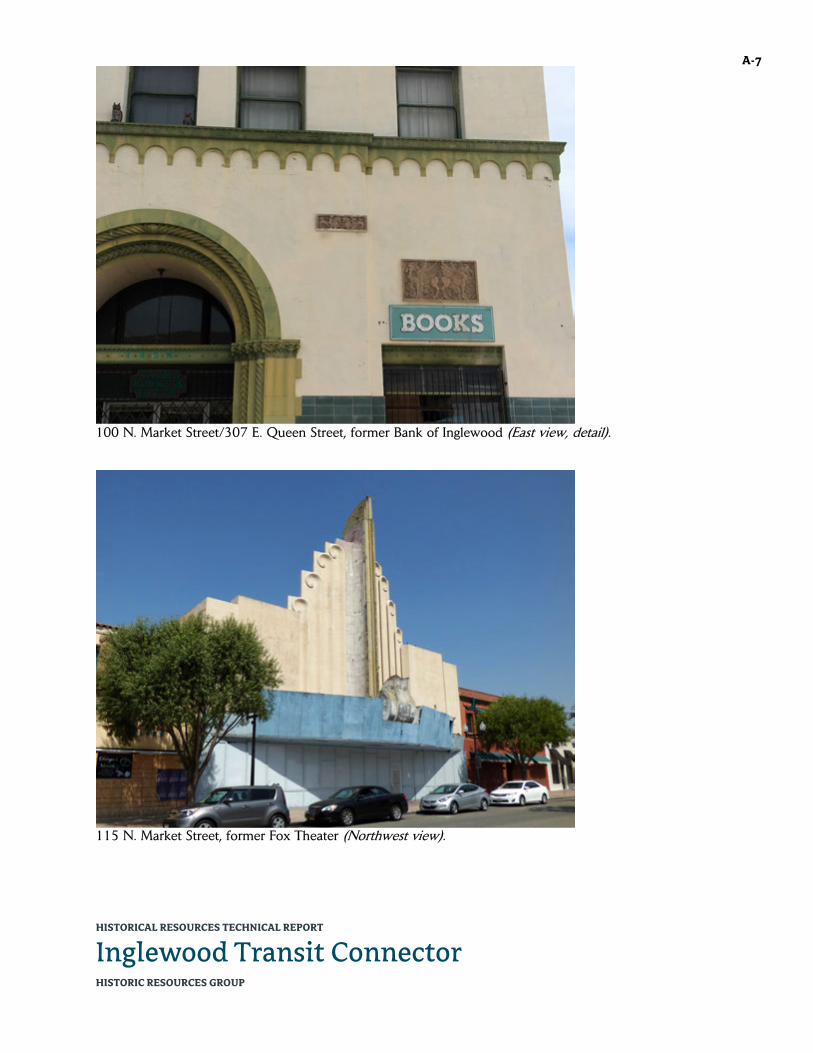
HISTORICAL RESOURCES TECHNICAL REPORT
Inglewood Transit Connector HISTORIC RESOURCES GROUP
A-7
100 N. Market Street/307 E. Queen Street, former Bank of Inglewood (East view, detail).
115 N. Market Street, former Fox Theater (Northwest view).

HISTORICAL RESOURCES TECHNICAL REPORT
Inglewood Transit Connector HISTORIC RESOURCES GROUP
A-8
115 N. Market Street, former Fox Theater (West view).
115 N. Market Street, former Fox Theater (Southwest view, detail).

HISTORICAL RESOURCES TECHNICAL REPORT
Inglewood Transit Connector HISTORIC RESOURCES GROUP
A-9
115 N. Market Street, former Fox Theater (Southwest view).
158-170 N. Market Street, former United Bank of California (East view).

HISTORICAL RESOURCES TECHNICAL REPORT
Inglewood Transit Connector HISTORIC RESOURCES GROUP
A-10
158-170 N. Market Street, former United Bank of California (Southeast view).
129-139 S. Market Street, former J.C. Penney (Southwest view).
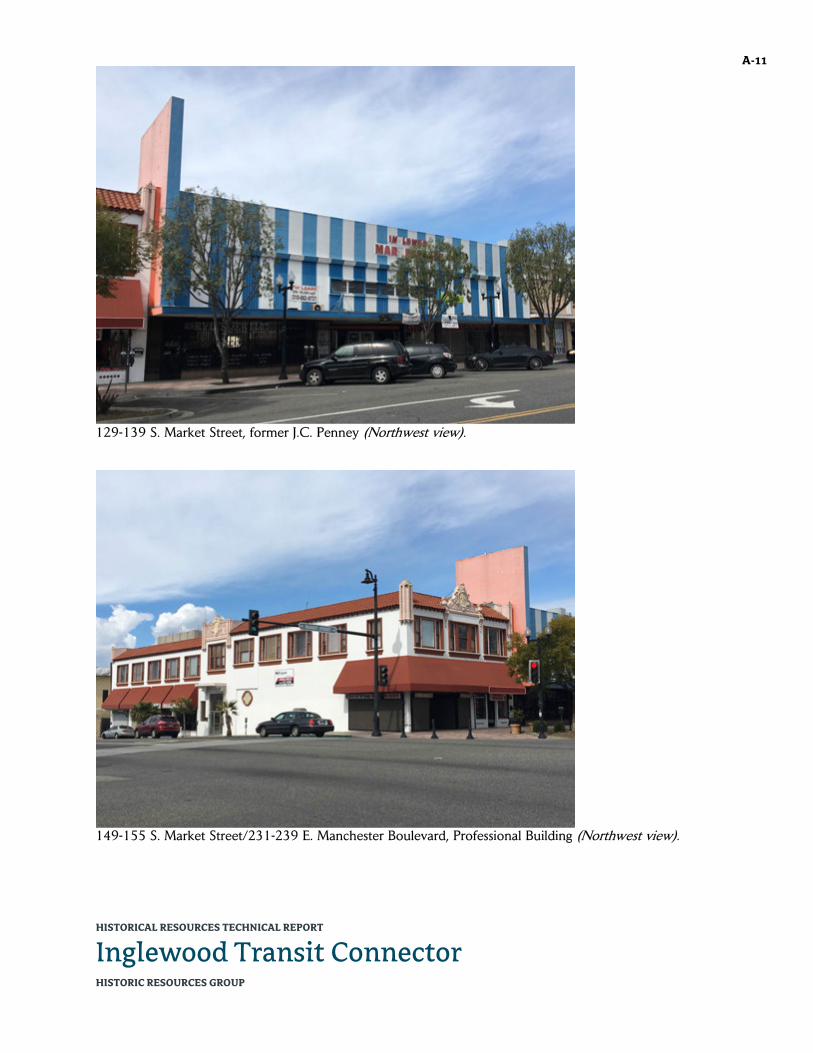
HISTORICAL RESOURCES TECHNICAL REPORT
Inglewood Transit Connector HISTORIC RESOURCES GROUP
A-11
129-139 S. Market Street, former J.C. Penney (Northwest view).
149-155 S. Market Street/231-239 E. Manchester Boulevard, Professional Building (Northwest view).

HISTORICAL RESOURCES TECHNICAL REPORT
Inglewood Transit Connector HISTORIC RESOURCES GROUP
A-12
149-155 S. Market Street/231-239 E. Manchester Boulevard, Professional Building (Northeast view).
149-155 S. Market Street/231-239 E. Manchester Boulevard, Professional Building (Southwest view, detail).

HISTORICAL RESOURCES TECHNICAL REPORT
Inglewood Transit Connector HISTORIC RESOURCES GROUP
A-13
150 S. Market Street, former People’s Federal Building & Loan Association (Northeast view).
150 S. Market Street, former People’s Federal Building & Loan Association (North view).
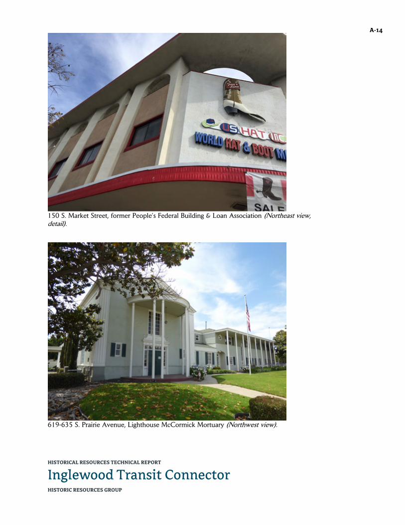
HISTORICAL RESOURCES TECHNICAL REPORT
Inglewood Transit Connector HISTORIC RESOURCES GROUP
A-14
150 S. Market Street, former People’s Federal Building & Loan Association (Northeast view, detail).
619-635 S. Prairie Avenue, Lighthouse McCormick Mortuary (Northwest view).

HISTORICAL RESOURCES TECHNICAL REPORT
Inglewood Transit Connector HISTORIC RESOURCES GROUP
A-15
619-635 S. Prairie Avenue, Lighthouse McCormick Mortuary (West view).
619-635 S. Prairie Avenue, Lighthouse McCormick Mortuary (Northwest view).
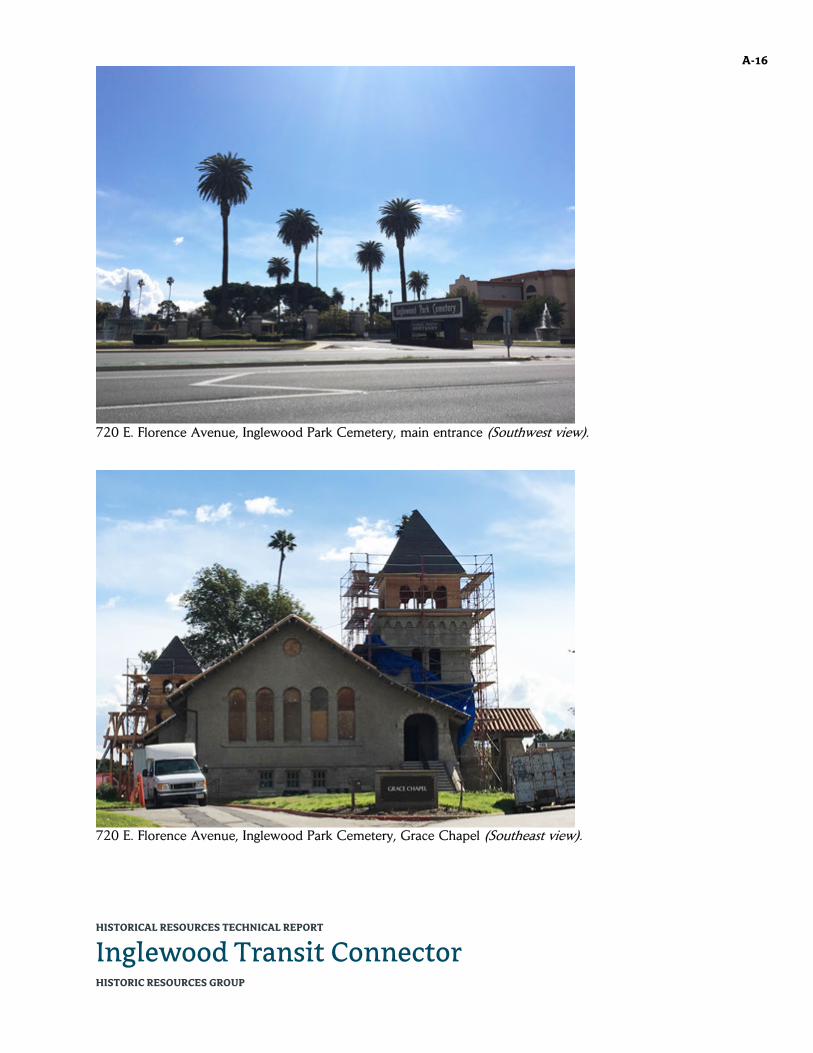
HISTORICAL RESOURCES TECHNICAL REPORT
Inglewood Transit Connector HISTORIC RESOURCES GROUP
A-16
720 E. Florence Avenue, Inglewood Park Cemetery, main entrance (Southwest view).
720 E. Florence Avenue, Inglewood Park Cemetery, Grace Chapel (Southeast view).

HISTORICAL RESOURCES TECHNICAL REPORT
Inglewood Transit Connector HISTORIC RESOURCES GROUP
A-17
720 E. Florence Avenue, Inglewood Park Cemetery, Inglewood Mausoleum (Northeast view).
720 E. Florence Avenue, Inglewood Park Cemetery, Mausoleum of the Golden West (North view).

HISTORICAL RESOURCES TECHNICAL REPORT
Inglewood Transit Connector HISTORIC RESOURCES GROUP
A-18
720 E. Florence Avenue, Inglewood Park Cemetery (West view).
Market Street, looking south toward Queen Street.

HISTORICAL RESOURCES TECHNICAL REPORT
Inglewood Transit Connector HISTORIC RESOURCES GROUP
A-19
Market Street, looking north from Queen Street.
Market Street, looking north from Manchester Boulevard.

HISTORICAL RESOURCES TECHNICAL REPORT
Inglewood Transit Connector HISTORIC RESOURCES GROUP
A-20
Manchester Boulevard, looking east toward Market Street.
Manchester Boulevard, looking west toward Market Street.

HISTORICAL RESOURCES TECHNICAL REPORT
Inglewood Transit Connector HISTORIC RESOURCES GROUP
A-21
Manchester Boulevard, looking west from Locust Street.
Prairie Avenue, looking north from Kelso Street.

HISTORICAL RESOURCES TECHNICAL REPORT
Inglewood Transit Connector HISTORIC RESOURCES GROUP
A-22
The Forum and Los Angeles Stadium from Inglewood Park Cemetery (Southwest view).

HISTORICAL RESOURCES TECHNICAL REPORT
Inglewood Transit Connector HISTORIC RESOURCES GROUP
B-1 APPENDIX B: LIST OF PARCELS IN THE PROJECT AREA AND EXPANDED STUDY AREA
The following is a complete listing of all parcels examined as part of the Project Area and Expanded Study Area for the proposed Project. This includes all parcels fronting the alignment right-of-way on both sides, and all parcels where new construction is proposed—including the Market Street Station site; the site where the pedestrian bridge will land; the Maintenance & Storage Facility (MSF) site; and the two Traction Power Substation sites. Where there will be substantial new construction outside of the alignment right-of-way, parcels immediately adjacent to or across from the new construction are also included.
ADDRESS APN DATE NAME/
DESCRIPTION
ALONG ALIGN-MENT
MSF (site or
adjacent) TPSS
PED BRIDGE
617 E Buckthorn St 4021044009 1925 Single-family residence X 300 E Florence Ave 4015027031 1967 Fiesta Martin Bar & Grill,
shopping center parking lot
X
310 E Florence Ave 4015027030 1973 X 317 E Florence Ave 4015019902 0 Vacant lot X 319 E Florence Ave 4015019904 0 Vacant lot X 325 E Florence Ave 4015019905 0 Vacant lot X 327 E Florence Ave 4015019906 0 Vacant lot X 330 E Florence Ave 4015027029 1978 X 333 E Florence Ave 4015019907 0 Vacant lot X 335 E Florence Ave 4015019908 0 Vacant lot X 409 Grace Ave 4015021044 1986 Strip mall, parking lot X 336 E Hillcrest Bl 4021023001 1962 5-story office building X 401 E Hillcrest Bl 4021012014 1953 New Wave Property, 1-
story commercial office building, parking lot
X
401 E Hillcrest Bl/256 S Locust St
4021012007 1946 Emerald Chateau, J.J.’s Bistro, 1-story commercial office building
X
421-427 E Hillcrest Bl 4021012011 1949 Kali Squeeze, 1-story commercial storefront building
X
431 E Hillcrest Bl 4021012010 1959 McCormick Ambulance, 1-story commercial office, parking lot
X
110 S La Brea Ave 4021009037 1987 5-story office building (on La Brea), rear parking lot (on Market)
X
130 N Locust Ave 4021006027 1970 Forum Dental Group, 1-story office building
X
151 N Locust Ave 4021007026 1977 Regent Towers, 7-story apartment complex
X

HISTORICAL RESOURCES TECHNICAL REPORT
Inglewood Transit Connector HISTORIC RESOURCES GROUP
B-2
ADDRESS APN DATE NAME/ DESCRIPTION
ALONG ALIGN-MENT
MSF (site or
adjacent) TPSS PED
BRIDGE
200-202 N Locust Ave/405-413 E Regent St
4015026038 1950 X
204 N Locust Ave 4015026037 1933 Single-family residence X 208 N Locust Ave 4015026029 1941 Single-family residence X 212 N Locust Ave 4015026028 1931 Single-family residence X 218 N Locust Ave 4015026027 1947 Single-family residence X 220 N Locust Ave 4015026026 1941 Single-family residence X 222-224 N Locust Ave 4015026025 1949 Multi-family residence X 228 N Locust Ave 4015026024 1942 Single-family residence X 232 N Locust Ave 4015026023 1949 X 236 N Locust Ave 4015026022 1945 X 240 N Locust Ave 4015026021 1925 X 244 N Locust Ave 4015026040,
4015026041, 4015026042, 4015026043, 4015026044, 4015026046, 4015026047, 4015026048, 4015026049
1960 X
248 N Locust Ave 4015026019 1951 1-story office building X 260 N Locust Ave 4015026039 1914 Holy Faith Episcopal
Church (church, rectory and school)
X
302 E Manchester Bl/200-204 S Market St
4021013019 1941 Cox Menswear, 2-story commercial building
X
320-330 E Manchester Bl 4021013018 1948 Bank of America X 335-337 E Manchester Bl 4021010023 1947 2-story professional
office building X
343-345 E Manchester Bl 4021010022 1942 2-story professional office building
X
355 E Manchester Bl 4021010021 1966 2-story professional office building
X
400-412 E Manchester Bl 4021012002 1962 1-story commercial storefronts
X
401 E Manchester Bl 4021006030 1999 McDonald’s, Flip It, 3 1-story commercial buildings, parking lot
X
420-424 E Manchester Bl 4021012001 1949 1-story commercial storefronts
X
428-440 E Manchester Bl 4021012008 1953 1-story commercial storefronts
X
450 E Manchester Bl 4021012015 1969 Bruno’s, walk-up food stand
X

HISTORICAL RESOURCES TECHNICAL REPORT
Inglewood Transit Connector HISTORIC RESOURCES GROUP
B-3
ADDRESS APN DATE NAME/ DESCRIPTION
ALONG ALIGN-MENT
MSF (site or
adjacent) TPSS PED
BRIDGE
500 E Manchester Bl 4021024015 1994 Vons supermarket, Vons gas station, parking lot
X X X
511-515 E Manchester Bl 4021025001 1938 H&R Block, Hillcrest Medical Clinic, 2-story mixed-use storefront/office building; 1-story commercial building
X
521-525 E Manchester Bl 4021025026 1951 1-story storefront building
X
529 E Manchester Bl 4021025017 1951 Mattress 4 Less, 1-story storefront building
X
600-604 E Manchester Bl 4021028237 2001 Auto service garage (multiple bays)
X
601-609 E Manchester Bl 4021027035 1962 1-story professional building
X
614-620 E Manchester Bl 4021028024 1964 RTJ Professional Building, 2-story professional building
X
652-656 E Manchester Bl 4021028025 1952 2-story storefront/office building
X
656-660 E Manchester Bl 4021028026 1956 1-story storefront building, parking lot
X
700 E Manchester Bl 4021036041 1960 Regal Cleaners, Martino's Liquor, 1-story commercial retail stores, parking lot
X
708 E Manchester Bl 4021036039 1965 2-story commercial office building
X
709 E Manchester Bl 4021027014 1906 1-story single-family residence
X
712 E Manchester Bl 4021036040 1950 A Bright Beginning, Inc., preschool
X
713 E Manchester Bl 4021027013 1926 1-story single-family residence
X
714-718 E Manchester Bl 4021036004 1968 Urban scholar academy, 1-story commercial building
X
718-732 E Manchester Bl 4021036005 1957 2-story commercial office building
X
801 E Manchester Bl 4021027038 1988 M&M Soul Food, parking lot
X
802 E Manchester Bl 4021036062 1970 Clean King laundromat X 808 E Manchester Bl 4021036025 1953 1-story commercial
office building X
811 E Manchester Bl 4021027028 1977 Midas auto service building
X
814 E Manchester Bl 4021036026 0 Parking lot X

HISTORICAL RESOURCES TECHNICAL REPORT
Inglewood Transit Connector HISTORIC RESOURCES GROUP
B-4
ADDRESS APN DATE NAME/ DESCRIPTION
ALONG ALIGN-MENT
MSF (site or
adjacent) TPSS PED
BRIDGE
815 E Manchester Bl 4021027027 0 Parking lot X 816 E Manchester Bl 4021036027 0 Parking lot X 831 E Manchester Bl 4021027036 1971 Sizzler, parking lot X 3900 W Manchester Bl 4025001002 1967 The Forum X 501 Manchester Ter 4021005013 1962 Airport Gas X 622 Manchester Dr 4021027003 1928 1-story single-family
residence X
100 N Market St/307 E Queen St
4021007024 1927 Vajra Books & Gifts, 2-story mixed-use commercial (former Bank of Inglewood)
X
101-107 N Market St/ 229-243 Queen St
4021008912 1929 2-story mixed-use commercial
X
110-114 N Market St 4021007020 1938 Storefronts X 115 N Market St 4021008006 1949 Former Fox Theater X 118-122 N Market St 4021007019 1930 I Sports Two, storefronts X 121-125 N Market St 4021008913 1924 2-story commercial
building X
122 N Market St 4021007018 1924 Creative House, 1-story commercial storefront building
X
124-126 N Market St 4021007017 1920 2-story commercial storefront building
X
128 N Market St 4021007016 1924 Heart & Soul Grill, 2-story mixed-use commercial
X
129 N Market St 4021008004 1927 Middlebar on Market X 132-134 N Market St 4021007015 1926 Los Angeles Bridge Unit,
1-story storefront building
X
133-137 N Market St 4021008003 1910 1-story commercial building, three storefronts
X
136-144 N Market St 4021007904 0 Vacant lot X 139 N Market St 4021008914 0 Vacant lot X 150-152 N Market St 4021007906 0 Vacant lot X 157-167 N Market St 4021008001 1907 1-story commercial
storefront building X
158-170 N Market St 4021007012 1967 Broadway Federal Bank (former Union Bank of California)
X
200 N Market St 4015027051 1976 Drive-thru bank tellers X 205 N Market St 4015028900 0 Parking lot X 210 N Market St 4015027050 1976 X

HISTORICAL RESOURCES TECHNICAL REPORT
Inglewood Transit Connector HISTORIC RESOURCES GROUP
B-5
ADDRESS APN DATE NAME/ DESCRIPTION
ALONG ALIGN-MENT
MSF (site or
adjacent) TPSS PED
BRIDGE
213 N Market St 4015028907 0 Vacant lot X 219 N Market St 4015028906 0 Vacant lot X 221 N Market St 4015028905 0 Vacant lot X 222 N Market St 4015027049 1976 X 223 N Market St 4015028901 0 Vacant lot X 224 N Market St 4015027041 1969 X 226 N Market St 4015027022 0 Shopping center parking
lot X
230 N Market St 4015027040 1965 X 234 N Market St 4015027020 0 Shopping center parking
lot X
236 N Market St 4015027035 0 Shopping center parking lot
X
237 N Market St 4015028903 0 Vacant lot X 240 N Market St 4015027038 1965 X 250 N Market St 4015027033 1965 X 254 N Market St 4015027032 1965 X 116-126 S Market St 4021010011 1927 Magee Building, 2-story
mixed-use commercial building
X
125 S Market St 4021009027 1938 Basket Beauty Supply, 1-story commercial storefront
X
128-130 S Market St 4021010012 1923 Handwritten LA, 2-story mixed-use commercial building
X
132 S Market St 4021010013 1925 Smoove Fashion World, 2-story mixed-use commercial building
X
129-139 S Market St 4021009031 1941, addition and remodel 1954
2-story commercial retail building (former J.C. Penney)
X
149-155 S Market St/231-239 E Manchester Bl
4021009017 1928 2-story commercial mixed-use building
X
150 S Market St 4021010015 1927, remodel c. 1965
World Hat & Boot Mart, 2-story mixed-use commercial building (former People’s Federal Building & Loan Association)
X
201-207 S Market St 4021014001 1935 Fashion Express, commercial storefront
X

HISTORICAL RESOURCES TECHNICAL REPORT
Inglewood Transit Connector HISTORIC RESOURCES GROUP
B-6
ADDRESS APN DATE NAME/ DESCRIPTION
ALONG ALIGN-MENT
MSF (site or
adjacent) TPSS PED
BRIDGE
333 E Nutwood St 4021013008 1940 Anphon Medical Center, 1-story commercial professional building
X
338 E Nutwood St, 320 E Nutwood St, 325 E Hillcrest Bl
4021016015 1936 2-story single-family residence converted to commercial office, 1-story commercial office addition, 1- and 2-story commercial building at rear
X
401 S Prairie Ave 4021036049 1984 2-story office building X 503 S Prairie Ave 4021037001 1949 2-story commercial
building X
517 S Prairie Ave 4021037903 c. 1950 William H. Kelso Elementary School, elementary school campus (expansion area)
X
600 S Prairie Ave 4025011064 0 Construction site X 600 S Prairie Ave 4025011065 0 Construction site X 601 S Prairie Ave 4021038025 1966 Bourbon Street Fish,
converted service station
X
613 S Prairie Ave 4021038005 1955 X 619-635 S Prairie Ave 4021038027 1948,
addition c. 1960
Lighthouse McCormick Mortuary (former Hardin & Flanagan Colonial Chapel and Mortuary)
X
701 S Prairie Ave 4021044001 0 Vacant lot X 703 S Prairie Ave 4021044004 c. 1925 2 1½-story single-family
residences X
711 S Prairie Ave 4021044005 1947 Single-family residence X 713 S Prairie Ave 4021044006 1982 Single-family residence X 715 S Prairie Ave 4021044007 1959 Single-family residence X 723 S Prairie Ave 4021044008 1922 Single-family residence X 801 S Prairie Ave 4024007001 1967 Forum Liquor X 803 S Prairie Ave 4024007004 0 Parking lot X 805 S Prairie Ave 4024007005 1947 1- and 2-story
apartment building X
813 S Prairie Ave 4024007006 1945 JP Termite, 1-story commercial storefront
X
819 S Prairie Ave 4024007007 1953 Iglesia Cristiana Hispana, 1-story commercial/industrial building
X

HISTORICAL RESOURCES TECHNICAL REPORT
Inglewood Transit Connector HISTORIC RESOURCES GROUP
B-7
ADDRESS APN DATE NAME/ DESCRIPTION
ALONG ALIGN-MENT
MSF (site or
adjacent) TPSS PED
BRIDGE
823-825 S Prairie Ave 4024007008 1948 Hollywood Park Motel X 901 S Prairie Ave 4024008024 1985 Strip mall X 919 S Prairie Ave 4024008020 1959 Inglewood Gardens, 2-
story apartment building X
923 S Prairie Ave 4024008015 1949 Inglewood Electric Supply, 2-story commercial building, 1-story commercial building, rear garage, parking lot
X
937 S Prairie Ave 4024009004 0 Vacant lot X 945 S Prairie Ave 4024009005 1969 Pride Plaza, 2-story
commercial retail/office building
X
1003 S Prairie Ave 4024009007 1957 1-story commercial office
X
1007 S Prairie Ave 4024009008 0 Vacant lot X 1011 S Prairie Ave 4024009015 1954 1-story commercial
office X
1035 S Prairie Ave 4024009033 1971 Strip mall, Casa Rios restaurant, parking lot
X
300 E Queen St, 306-308 E Queen St, 100-112 S Market St
4021010010 1990 2-story mixed-use commercial building
X
312 E Regent St 4021007011 0 Vacant lot X 331 E Spruce Ave 4021023011 1915 Tender Care, Inc., two
single-family residences converted to a school
X
336 E Spruce Ave 4021029009 1922 Wilder's Preparatory Academy, 1-story single-family residence converted to a school
X
430-434 E Spruce Ave 4021028125-4021028172
1989 Part of a condominium complex
X
436-438 E Spruce Ave, 433-435 E Tamarack Ave
4021028173-4021028236
1989 Part of a condominium complex
X
(none) 4012031930 1905 Inglewood Park Cemetery
X
(none) 4015018900 0 Metro right-of-way X (none) 4015027042 0 Shopping center parking
lot X
(none) 4015027052 0 Shopping center parking lot
X
(none) 4021010901 0 Parking lot X (none) 4021025025 0 Parking lot X (none) 4021027012 0 Vacant lot X

HISTORICAL RESOURCES TECHNICAL REPORT
Inglewood Transit Connector HISTORIC RESOURCES GROUP
B-8
ADDRESS APN DATE NAME/ DESCRIPTION
ALONG ALIGN-MENT
MSF (site or
adjacent) TPSS PED
BRIDGE
(none) 4021027015 0 Vacant lot X (none) 4024007043 2003 Laundromat X (none) 4025011043 0 Construction site X (none) 4025011050 0 Construction site X (none) 4025011901 0 Construction site X X

4.4.3
Historic Resources Technical Report

HISTORICAL RESOURCES TECHNICAL REPORT
Inglewood Transit Connector December 2019 HISTORIC RESOURCES GROUP
12 S. Fair Oaks Avenue, Suite 200, Pasadena, CA 91105-3816 Telephone 626 793 2400, Facsimile 626 793 2401 www.historicresourcesgroup.com

HISTORICAL RESOURCES TECHNICAL REPORT
Inglewood Transit Connector HISTORIC RESOURCES GROUP
PREPARED FOR
Pacifica Services, Inc. 106 S. Mentor Avenue #200 Pasadena CA 91106
COVER PHOTO: Market Street, looking south from Regent Street, 1960. (Inglewood Public Library, Online Archive of California)

HISTORICAL RESOURCES TECHNICAL REPORT
Inglewood Transit Connector HISTORIC RESOURCES GROUP
TABLE OF CONTENTS
1.0 Summary of Findings 1
2.0 Proposed Project 2
3.0 Methodology 7
4.0 Regulatory Setting 12
5.0 Historic Context 19
6.0 Identification of Historical Resources 39
7.0 Potential Impacts 54
8.0 Recommended Mitigation Measures 69
Bibliography 71
Appendix A: Field Photographs
Appendix B: List of Parcels in the Project Area and Expanded Study Area
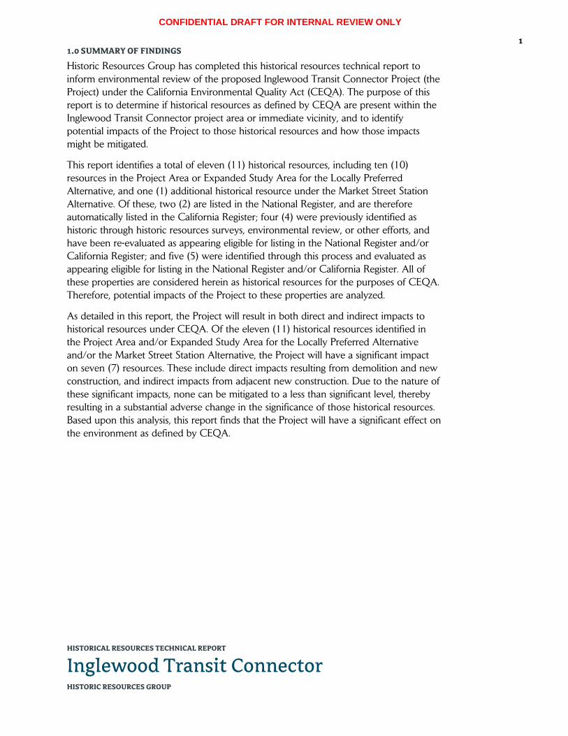
CONFIDENTIAL DRAFT FOR INTERNAL REVIEW ONLY
HISTORICAL RESOURCES TECHNICAL REPORT
Inglewood Transit Connector HISTORIC RESOURCES GROUP
1 1.0 SUMMARY OF FINDINGS
Historic Resources Group has completed this historical resources technical report to inform environmental review of the proposed Inglewood Transit Connector Project (the Project) under the California Environmental Quality Act (CEQA). The purpose of this report is to determine if historical resources as defined by CEQA are present within the Inglewood Transit Connector project area or immediate vicinity, and to identify potential impacts of the Project to those historical resources and how those impacts might be mitigated.
This report identifies a total of eleven (11) historical resources, including ten (10) resources in the Project Area or Expanded Study Area for the Locally Preferred Alternative, and one (1) additional historical resource under the Market Street Station Alternative. Of these, two (2) are listed in the National Register, and are therefore automatically listed in the California Register; four (4) were previously identified as historic through historic resources surveys, environmental review, or other efforts, and have been re-evaluated as appearing eligible for listing in the National Register and/or California Register; and five (5) were identified through this process and evaluated as appearing eligible for listing in the National Register and/or California Register. All of these properties are considered herein as historical resources for the purposes of CEQA. Therefore, potential impacts of the Project to these properties are analyzed.
As detailed in this report, the Project will result in both direct and indirect impacts to historical resources under CEQA. Of the eleven (11) historical resources identified in the Project Area and/or Expanded Study Area for the Locally Preferred Alternative and/or the Market Street Station Alternative, the Project will have a significant impact on seven (7) resources. These include direct impacts resulting from demolition and new construction, and indirect impacts from adjacent new construction. Due to the nature of these significant impacts, none can be mitigated to a less than significant level, thereby resulting in a substantial adverse change in the significance of those historical resources. Based upon this analysis, this report finds that the Project will have a significant effect on the environment as defined by CEQA.

CONFIDENTIAL DRAFT FOR INTERNAL REVIEW ONLY
HISTORICAL RESOURCES TECHNICAL REPORT
Inglewood Transit Connector HISTORIC RESOURCES GROUP
2 2.0 PROPOSED PROJECT1
Locally Preferred Alternative
Under the Locally Preferred Alternative, the Inglewood Transit Connector (ITC) Project (proposed Project) would develop an automated people mover (APM) system to connect Downtown Inglewood near the Metro Crenshaw/LAX Line to the city’s major activity centers including the Forum, the Los Angeles Stadium and Entertainment District (LASED) at Hollywood Park, and the proposed Inglewood Basketball and Entertainment Center (IBEC).
The proposed APM system would be a fully automated, grade-separated train system consisting of an elevated dual-lane guideway, largely contained within the public rights-of-way, running for approximately 1.8 miles for the length of the alignment. The APM guideway would begin on Market Street near the Downtown Inglewood Metro station and proceed south on Market Street, then east on Manchester Boulevard, and turning south on Prairie Avenue until its intersection with Century Boulevard. [See Figure 1. Project Location Map.]
The APM guideway would be between 37 and 43 feet above grade, varying in width at track switches and stations. Both lanes of the APM guideway would be situated on one side of the right-of-way in between stations and generally be supported by single columns, then gradually transition to opposite sides of the right-of-way on approach to station platforms where they would be supported by dual columns on both sides of the street. The APM guideway would be approximately 80 feet wide when oriented on opposite sides of the roadway right-of-way and approximately 30 feet wide when situated on one side of the roadway.
The APM system would include up to five stations with proposed locations along Market Street, along Manchester Boulevard, at the Forum, at Hollywood Park, and near Century Boulevard. Stations would generally be sized approximately 300 to 400 feet long and 50 to 100 feet wide, and would include ground, mezzanine, and guideway platform levels. In general, mezzanine levels would be approximately 25 feet high, the guideway platforms would be approximately 50 feet high, and the top of station enclosures would be approximately 75 feet high.
In addition, the proposed Project would include other support facilities including a Maintenance & Storage Facility (MSF) to accommodate storage, maintenance, and cleaning of the APM train cars; an Intermodal Transportation Facility (ITF); and Traction Power Substations (TPSS). For the most part, these support facilities would be located along the alignment and on properties adjacent to the APM system. [See Figure 2. Project Area Map (Locally Preferred Alternative).]
1 Description of the Project as provided by the Applicant.

CONFIDENTIAL DRAFT FOR INTERNAL REVIEW ONLY
HISTORICAL RESOURCES TECHNICAL REPORT
Inglewood Transit Connector HISTORIC RESOURCES GROUP
3
Market Street Station Alternative
The Market Street Station Alternative would provide for an alternative location for the Market Street APM station and for additional mixed-use development adjacent to the station. This Alternative proposes to locate the Market Street APM station further northeast in closer proximity to the Downtown Inglewood Metro station and on adjacent property at the southeastern corner of Florence Avenue and Market Street. This property is bounded by Florence Avenue, Locust Street, Regent Street, and Market Street and is currently developed as a commercial shopping center. The Market Street Station Alternative would include a pedestrian connection across Florence Avenue connecting to the existing Metro station. Additionally, this Alternative would enable the joint development of approximately 600,000 to 700,000 square feet of mixed use (commercial, hotel, and residential uses) adjacent to the station. [See Figure 3. Project Area Map (Market Street Station Alternative).]
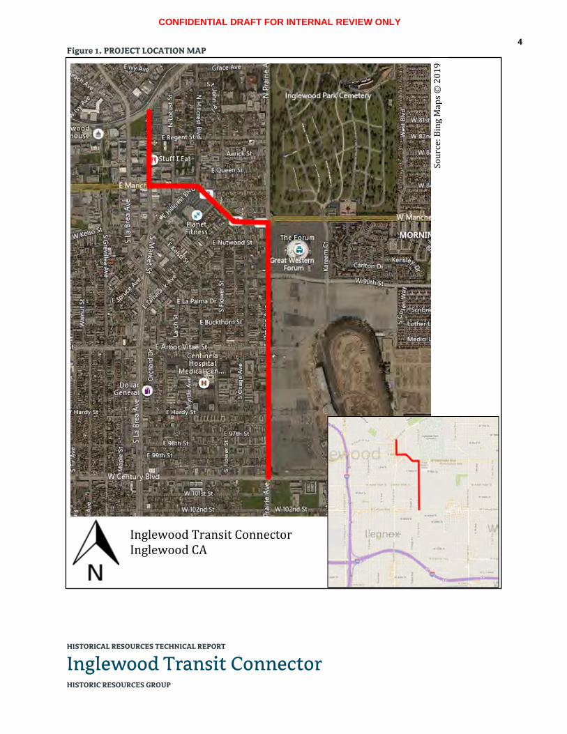
CONFIDENTIAL DRAFT FOR INTERNAL REVIEW ONLY
HISTORICAL RESOURCES TECHNICAL REPORT
Inglewood Transit Connector HISTORIC RESOURCES GROUP
4 Figure 1. PROJECT LOCATION MAP
Inglewood Transit Connector Inglewood CA
Sour
ce: B
ing
Map
s ©
201
9

CONFIDENTIAL DRAFT FOR INTERNAL REVIEW ONLY
HISTORICAL RESOURCES TECHNICAL REPORT
Inglewood Transit Connector HISTORIC RESOURCES GROUP
5 Figure 2. PROJECT AREA MAP (LOCALLY PREFERRED ALTERNATIVE)

CONFIDENTIAL DRAFT FOR INTERNAL REVIEW ONLY
HISTORICAL RESOURCES TECHNICAL REPORT
Inglewood Transit Connector HISTORIC RESOURCES GROUP
6 Figure 3. PROJECT AREA MAP (MARKET STREET STATION ALTERNATIVE)

CONFIDENTIAL DRAFT FOR INTERNAL REVIEW ONLY
HISTORICAL RESOURCES TECHNICAL REPORT
Inglewood Transit Connector HISTORIC RESOURCES GROUP
7 3.0 METHODOLOGY
This report analyzes the Inglewood Transit Connector project’s Locally Preferred Alternative, as well as the Market Street Station Alternative. For each of these project scenarios, this report examines the site of the proposed Project (Project Area) and immediately surrounding area (Expanded Study Area) to determine if historical resources are present.
The “Project Area” comprises all areas and parcels where new construction will occur. Under the Locally Preferred Alternative, this includes the public rights-of-way along Market Street, Manchester Boulevard, and Prairie Avenue where the elevated APM guideway and five APM stations will be constructed; parcels east of Market Street between Florence and Regent where vertical circulation elements (escalators, elevators, stairs) for the Market Street Station will land; a parcel north of Florence Avenue where a pedestrian bridge from the Market Street Station will land; the block bounded by Manchester Boulevard, Hillcrest Boulevard, Nutwood Street, and Spruce Avenue where the Maintenance & Storage Facility and possibly a Traction Power Substation will be built, and where vertical circulation elements for the Manchester Boulevard Station will land; parcels east of Prairie Avenue between Manchester and Century where the roadway will be widened to the east; the parcel east of Prairie Avenue between Manchester and Pincay (the Forum property) where a Traction Power Substation may be built and vertical circulation elements for the Forum Station will land; the parcel east of Prairie Avenue and south of Arbor Vitae Street where the Intermodal Transportation Facility and possibly a Traction Power Substation will be built, and where vertical circulation elements for the Hollywood Park Station will land; and the parcel at the northeast corner of Prairie Avenue and Century Boulevard where a Traction Power Substation may be built and vertical circulation elements for the Century Boulevard Station will land.
Under the Market Street Station Alternative, the Project Area also includes the block bounded by Market Street, Florence Avenue, Locust Street, and Regent Street where the elevated APM guideway and Market Street Station would be constructed; and parcels north of Florence Avenue where a pedestrian bridge from the Market Street Station will land.
The “Expanded Study Area” has been defined to encompass what is expected to be the maximum extent within which project impacts will occur. The Expanded Study Area includes all parcels fronting the alignment right-of-way on both sides.2 In addition, where there will be substantial new construction outside of the alignment right-of-way, parcels immediately adjacent to or across from the new construction have been included in the
2 The parcel at the northeast corner of Manchester Boulevard and Prairie Avenue is included in the Expanded Study Area because it fronts the alignment right-of-way. While this parcel extends several blocks north of the Project Area to Florence Avenue, project impacts would only be expected in the southernmost portion of the parcel.

CONFIDENTIAL DRAFT FOR INTERNAL REVIEW ONLY
HISTORICAL RESOURCES TECHNICAL REPORT
Inglewood Transit Connector HISTORIC RESOURCES GROUP
8
Expanded Study Area. This includes parcels adjacent to or across from the Maintenance & Storage Facility site; the Intermodal Transportation Facility site; the sites where the pedestrian bridges will land; and the four possible Traction Power Substation sites. Under the Market Street Station Alternative, this also includes parcels adjacent to or across from the block where the elevated APM guideway and Market Street Station would be constructed. [See Figure 4. Expanded Study Area Map (Locally Preferred Alternative) and Figure 5. Expanded Study Area Map (Market Street Station Alternative).]
Where historical resources exist within the Project Area or Expanded Study Area, this report analyzes project impacts for any adverse change in the significance of these resources. In doing so, this report provides a comprehensive review of historical resources that could be impacted, directly or indirectly, by the proposed Project. To this end, this report contains:
A review of the existing buildings, structures, objects and landscape areas located within the Project Area and Expanded Study Area.
A review of previous evaluations within the Project Area and Expanded Study Area through historic survey, environmental review, or other official actions.
Identification and evaluation of historical resources within the Project Area and Expanded Study Area.
Analysis of potential impacts to historical resources within the Project Area and Expanded Study Area.
For the purpose of this report, properties within the Project Area or Expanded Study Area have been evaluated for their eligibility for listing in the National Register of Historic Places (NRHP) and the California Register of Historical Resources (CRHR).
This report was prepared using primary and secondary sources related to the history and development of the City of Inglewood generally, with an emphasis on the early-20th century central business district that comprises much of the Project Area and Expanded Study Area. Documents that were consulted include:
Previous historical resources surveys and assessments
Previous environmental reviews
City of Inglewood historical building permits3
Los Angeles County Tax Assessor records
Sanborn Fire Insurance maps
Historical photographs and aerial images
3 Analysis in this report is based upon available building permits as provided by the City of Inglewood.

CONFIDENTIAL DRAFT FOR INTERNAL REVIEW ONLY
HISTORICAL RESOURCES TECHNICAL REPORT
Inglewood Transit Connector HISTORIC RESOURCES GROUP
9
Historical newspapers and other periodicals
Local histories and historic context statements
California State Historic Resources Inventory, Los Angeles County
Research, field inspection, and analysis were performed by Paul Travis, AICP, Managing Principal; and Kari Fowler, Senior Preservation Planner, both of whom are qualified professionals who meet or exceed the Secretary of the Interior’s Professional Qualification Standards. Additional assistance was provided by Robby Aranguren, Planning Associate/GIS Specialist.
[For a complete listing of all parcels examined as part of the Project Area and Expanded Study Area for the Inglewood Transit Connector Locally Preferred Alternative and Market Street Station Alternative, see Appendix B.]

CONFIDENTIAL DRAFT FOR INTERNAL REVIEW ONLY
HISTORICAL RESOURCES TECHNICAL REPORT
Inglewood Transit Connector HISTORIC RESOURCES GROUP
10 Figure 4. EXPANDED STUDY AREA MAP (LOCALLY PREFERRED ALTERNATIVE)

CONFIDENTIAL DRAFT FOR INTERNAL REVIEW ONLY
HISTORICAL RESOURCES TECHNICAL REPORT
Inglewood Transit Connector HISTORIC RESOURCES GROUP
11 Figure 5. EXPANDED STUDY AREA MAP (MARKET STREET STATION ALTERNATIVE)

CONFIDENTIAL DRAFT FOR INTERNAL REVIEW ONLY
HISTORICAL RESOURCES TECHNICAL REPORT
Inglewood Transit Connector HISTORIC RESOURCES GROUP
12 4.0 REGULATORY SETTING
4.1 Historical Resources under CEQA
The California Environmental Quality Act (CEQA) requires that environmental protection be given significant consideration in the decision-making process. Historical resources are included under environmental protection. Thus, any project or action which constitutes a substantial adverse change in the significance of a historical resource also has a significant effect on the environment and shall comply with the State CEQA Guidelines.
When the California Register of Historical Resources was established in 1992, the Legislature amended CEQA to clarify which cultural resources are significant, as well as which project impacts are considered to be significantly adverse. A “substantial adverse change” means “demolition, destruction, relocation, or alteration such that the significance of a historical resource would be impaired.”
CEQA defines a historical resource as a resource listed in, or determined eligible for listing, in the California Register of Historical Resources. All properties on the California Register are to be considered under CEQA. However, because a property does not appear on the California Register does not mean it is not significant and therefore exempt from CEQA consideration. All resources determined eligible for the California Register are also to be considered under CEQA.
The courts have interpreted CEQA to create three categories of historical resources:
Mandatory historical resources are resources “listed in, or determined to be eligible for listing in, the California Register of Historical Resources.”
Presumptive historical resources are resources “included in a local register of historical resources, as defined in subdivision (k) of Section 5020.1, or deemed significant pursuant to criteria set forth in subdivision (g) of Section 5024.1” of the Public Resources Code, unless the preponderance of the evidence demonstrates that the resource is not historically or culturally significant.
Discretionary historical resources are those resources that are not listed but determined to be eligible under the criteria for the California Register of Historical Resources.4
To simplify the first three definitions provided in the CEQA statute, a historical resource is a resource that is:
Listed in the California Register of Historical Resources;
4 League for the Protection of Oakland’s Architectural and Historic Resources vs. City of Oakland, 52 Cal. App. 4th 896, 906-7 (1997).

CONFIDENTIAL DRAFT FOR INTERNAL REVIEW ONLY
HISTORICAL RESOURCES TECHNICAL REPORT
Inglewood Transit Connector HISTORIC RESOURCES GROUP
13
Determined eligible for the California Register by the State Historical Resources Commission; or
Included in a local register of historical resources.
Section 15064.5 of the CEQA Guidelines (California Code of Regulations, Title 14, Chapter 3) supplements the statute by providing two additional definitions of historical resources, which may be simplified in the following manner. A historical resource is a resource that is:
Identified as significant in a historical resource survey meeting the requirements of Public Resources Code 5024.1(g);
Determined by a Lead Agency to be historically significant or significant in the architectural, engineering, scientific, economic, agricultural, educational, social, political, military, or cultural annals of California. Generally, this category includes resources that meet the criteria for listing on the California Register (Pub. Res. Code SS5024.1, Title 14 CCR, Section 4852).
The fact that a resource is not listed in, or determined eligible for listing in, the California Register, not included in a local register of historical resources, or not deemed significant pursuant to criteria set forth in subdivision (g) of Section 5024.1, does not preclude a lead agency from determining that the resource may be an “historical resource” for purposes of CEQA.
Properties formally determined eligible for listing in the National Register of Historic Places are automatically listed in the California Register. Properties designated by local municipalities can also be considered historical resources. A review of properties that are potentially affected by a project for historic eligibility is also required under CEQA.
4.2 Historic Designations
A property may be designated as historic by National, State, and local authorities. In order for a building to qualify for listing in the National Register or the California Register, it must meet one or more identified criteria. The property must also retain sufficient architectural integrity to continue to evoke the sense of place and time with which it is historically associated.
National Register of Historic Places
The National Register of Historic Places is an authoritative guide to be used by Federal, State, and local governments, private groups and citizens to identify the Nation’s cultural resources and to indicate what properties should be considered for protection from destruction or impairment.5 The National Park Service administers the National Register
5 36CFR60, Section 60.2.

CONFIDENTIAL DRAFT FOR INTERNAL REVIEW ONLY
HISTORICAL RESOURCES TECHNICAL REPORT
Inglewood Transit Connector HISTORIC RESOURCES GROUP
14
program. Listing in the National Register assists in preservation of historic properties in several ways including: recognition that a property is of significance to the nation, the state, or the community; consideration in the planning for Federal or Federally assisted projects; eligibility for Federal tax benefits; and qualification for Federal assistance for historic preservation, when funds are available.
To be listed in or eligible for listing in the National Register, a resource must possess significance in American history and culture, architecture, or archaeology. Listing in the National Register is primarily honorary and does not in and of itself provide protection of a historical resource. The primary effect of listing in the National Register on private owners of historic buildings is the availability of financial and tax incentives. In addition, for projects that receive Federal funding, a clearance process must be completed in accordance with Section 106 of the National Historic Preservation Act. Furthermore, state and local regulations may apply to properties listed in the National Register.
The criteria for listing in the National Register follow established guidelines for determining the significance of properties. The quality of significance in American history, architecture, archeology, engineering, and culture is present in districts, sites, buildings, structures, and objects:
A. That are associated with events that have made a significant contribution to the broad patterns of our history; or
B. That are associated with the lives of persons significant in our past; or
C. That embody the distinctive characteristics of a type, period, or method of construction, or that represent the work of a master, or that possess high artistic values, or that represent a significant and distinguishable entity whose components may lack individual distinction; or
D. That have yielded, or may be likely to yield, information important in prehistory or history.6
In addition to meeting any or all of the criteria listed above, properties nominated must also possess historic integrity. According to National Park Service guidance for applying National Register criteria, a property that is more than 50 years of age can be considered for listing in the National Register. Fifty years is a general estimate of time needed to develop historical perspective and therefore to evaluate historic significance.7
6 36CFR60, Section 60.3. 7 National Register Bulletin 15: How to Apply the National Register Criteria for Evaluation (Washington,
DC: National Park Service, 1995), 41.

CONFIDENTIAL DRAFT FOR INTERNAL REVIEW ONLY
HISTORICAL RESOURCES TECHNICAL REPORT
Inglewood Transit Connector HISTORIC RESOURCES GROUP
15
California Register of Historical Resources
The California Register is an authoritative guide in California used by State and local agencies, private groups, and citizens to identify the State's historical resources and to indicate what properties are to be protected, to the extent prudent and feasible, from substantial adverse change to their significance.8
The criteria for listing in the California Register are based upon National Register criteria. A property may be listed in the California Register if it:
1. Is associated with events that have made a significant contribution to the broad patterns of local or regional history or the cultural heritage of California or the United States.
2. Is associated with the lives of persons important to local, California or national history.
3. Embodies the distinctive characteristics of a type, period, region or method of construction or represents the work of a master or possesses high artistic values.
4. Has yielded, or has the potential to yield, information important to the prehistory or history of the local area, California or the nation.9
The California Register consists of resources that are listed automatically and those that must be nominated through an application and public hearing process. The California Register includes the following:
California properties formally determined eligible for (Category 2 in the State Inventory of Historical Resources), or listed in (Category 1 in the State Inventory), the National Register of Historic Places.
State Historical Landmarks No. 770 and all consecutively numbered state historical landmarks following No. 770. For state historical landmarks preceding No. 770, the Office of Historic Preservation (OHP) shall review their eligibility for the California Register in accordance with procedures to be adopted by the State Historical Resources Commission (commission).
Points of historical interest which have been reviewed by the OHP and recommended for listing by the commission for inclusion in the California Register in accordance with criteria adopted by the commission.10
Other resources which may be nominated for listing in the California Register include:
Individual historical resources.
Historical resources contributing to the significance of a historic district.
8 California PRC, Section 5023.1(a). 9 California PRC, Section 5024.1(c). 10 California PRC, Section 5023.1(d).

CONFIDENTIAL DRAFT FOR INTERNAL REVIEW ONLY
HISTORICAL RESOURCES TECHNICAL REPORT
Inglewood Transit Connector HISTORIC RESOURCES GROUP
16
Historical resources identified as significant in historical resources surveys, if the survey meets the criteria listed in subdivision (g).
Historical resources and historic districts designated or listed as city or county landmarks or historic properties or districts pursuant to any city or county ordinance, if the criteria for designation or listing under the ordinance have been determined by the office to be consistent with California Register criteria.
Local landmarks or historic properties designated under any municipal or county ordinance.11
Guidance for applying the California Register criteria does not provide a specific age threshold for eligibility. However, it does state that “sufficient time must have passed to obtain a scholarly perspective on the events or individuals associated with the resource.”12
Local Designation
The City of Inglewood does not have a historic preservation ordinance and does not maintain a local designation program.
4.3 Historic Significance
The definition of historic significance used by the California Office of Historic Preservation (OHP) in its administration of the California Register is based upon the definition used by the National Park Service for the National Register. Historic significance is defined as the importance of a property to the history, architecture, archaeology, engineering, or culture of a community, state, or the nation.13 It is achieved in several ways:
Association with important events, activities or patterns
Association with important persons
Distinctive physical characteristics of design, construction, or form
Potential to yield important information
A property may be significant individually or as part of a grouping of properties.
11 California PRC, Section 5023.1(e). 12 California Office of Historic Preservation, Technical Assistance Series #6, California Register and National
Register: A Comparison (for purposes of determining eligibility for the California Register), (Sacramento, CA: California Department of Parks and Recreation), 3.
13 National Register Bulletin 16A. How to Complete the National Register Registration Form (Washington D.C.: National Park Service, U.S. Department of the Interior, 1997), 3.

CONFIDENTIAL DRAFT FOR INTERNAL REVIEW ONLY
HISTORICAL RESOURCES TECHNICAL REPORT
Inglewood Transit Connector HISTORIC RESOURCES GROUP
17
4.4 Historic Integrity
Historic integrity is the ability of a property to convey its significance. It is defined as the “authenticity of a property’s historic identity, evidenced by the survival of physical characteristics that existed during the property’s historic period.”14 The National Park Service defines seven aspects of integrity: location, design, setting, materials, workmanship, feeling, and association. These qualities are defined as follows:
Location is the place where the historic property was constructed or the place where the historic event occurred.
Design is the combination of elements that create the form, plan, space, structure, and style of a property.
Setting is the physical environment of a historic property.
Materials are the physical elements that were combined or deposited during a particular period of time and in a particular pattern or configuration to form a historic property.
Workmanship is the physical evidence of the crafts of a particular culture or people during any given period in history or prehistory.
Feeling is a property's expression of the aesthetic or historic sense of a particular period of time.
Association is the direct link between an important historic event or person and a historic property.15
4.5 Period of Significance
The National Park Service defines the period of significance as “the length of time when a property was associated with important events, activities or persons, or attained the characteristics which qualify it for… listing” in National, State or local registers. A period of significance can be “as brief as a single year… [or] span many years.” It is based on “specific events directly related to the significance of the property,” for example the date of construction, years of ownership, or length of operation as a particular entity.16
4.6 Historic Districts
Standard preservation practice evaluates collections of buildings from similar time periods and historic contexts as historic districts. The National Park Service defines a historic district as “a significant concentration, linkage, or continuity of sites, buildings,
14 National Register Bulletin 16A, 3. 15 National Register Bulletin 15, 44-45. 16 National Register Bulletin 16A, 42.

CONFIDENTIAL DRAFT FOR INTERNAL REVIEW ONLY
HISTORICAL RESOURCES TECHNICAL REPORT
Inglewood Transit Connector HISTORIC RESOURCES GROUP
18
structures, or objects united historically or aesthetically by plan or physical development.”17 A historic district derives its significance as a single unified entity.
According to the National Park Service, “a district can comprise both features that lack individual distinction and individually distinctive features that serve as focal points. It may even be considered eligible if all of the components lack individual distinction, provided that the grouping achieves significance as a whole within its historic context. In either case, the majority of the components that add to the district's historic character, even if they are individually undistinguished, must possess integrity, as must the district as a whole.” Some examples of districts include business districts, college campuses, large estates, farms, industrial complexes, residential areas and rural villages.18
Properties that have been found to contribute to the historic significance of a district are referred to as district contributors. Properties located within the district boundaries that do not contribute to its significance are identified as non-contributors.
17 National Register Bulletin 15, 5. 18 Ibid.

CONFIDENTIAL DRAFT FOR INTERNAL REVIEW ONLY
HISTORICAL RESOURCES TECHNICAL REPORT
Inglewood Transit Connector HISTORIC RESOURCES GROUP
19 5.0 HISTORIC CONTEXT
5.1 Development History The following narrative describes the evolution of the Project Area and vicinity over time, with an emphasis on the early development of Inglewood and its downtown business district. The purpose of this narrative is to provide guidance for evaluating the historic significance of properties within the Project Area and Expanded Study Area, and for determining their eligibility for listing or designation according to established criteria and integrity thresholds.
Pre-History
In the pre-historical period, the coastal plain between present-day Los Angeles and Long Beach was immensely fertile, enriched by the periodic flooding of the Los Angeles River over millennia. It was home to the Tongva people, also referred as the Gabrieleño, Fernandeño, or Nicoleño, the names given to the region’s indigenous people by California’s Spanish missionaries. The Tongva occupied the area now encompassed by the Los Angeles basin, San Fernando Valley, San Gabriel Valley, San Bernardino Valley, and the local California coastline. The South Bay region was home to a number of small Tongva (Gabrieleño) villages, with notable settlements at Suangna near the present-day city of Carson, near Point Fermin in San Pedro, and near Malaga Cove in Palos Verdes.19
Spanish Colonial and Mexican Periods
In 1542, Spanish explorer Juan Rodriguez Cabrillo led the first European expedition to explore what is now the west coast of North America. Explorers with Cabrillo’s expedition encountered native people on land and sea voyages, making what is thought to be the first known contact with Alta California’s indigenous tribes, including the Tongva of the Suangna area.20 While Cabrillo claimed California for the Spanish Crown at this time, Spanish settlement would not reach this territory for another two hundred years.
On July 14th, 1769, Don Gaspar de Portolá, governor and military leader of Baja California, led the first expedition to colonize Alta California. Accompanied by Franciscan friars Junípero Serra and Juan Crespí, Portolá took a group of 64 men northward from San Diego toward Monterey. On August 2nd, the expedition camped along the east bank of the Los Angeles River just south of where it is joined by the Arroyo Seco. Fr. Crespí named the spot “El Pueblo de Nuestra Señora la Reina de los Ángeles del Río Porciúncula (translating as “town of Our Lady the Queen of Angels of the River Porciúncula”). As the expedition crossed the river and continued to the south
19 Sam Gnerre, “The Suangna Native American Village in Carson,” South Bay Daily Breeze, January 17, 2015.
20 Ibid.

CONFIDENTIAL DRAFT FOR INTERNAL REVIEW ONLY
HISTORICAL RESOURCES TECHNICAL REPORT
Inglewood Transit Connector HISTORIC RESOURCES GROUP
20
and west approximately one mile, they encountered the Tongva village of Yang-na, believed to be near the current site of El Pueblo de Los Angeles.
On September 8th, 1771, Spanish colonists established Mission San Gabriel, the fourth of an eventual 21 Spanish missions in California, and the first in this area. Much of the area’s native population would be recruited to work the San Gabriel Mission lands. Seven years later, in 1778, Governor Felipe de Neve received approval for the creation of a civil pueblo along the Río la Porciúncula. Persuaded by Crespi’s earlier descriptions of a well-watered valley with good soils for growing crops and an ample native population to work the land, the Spanish colonial government ordered Governor Neve to establish a settlement at this location and name the new pueblo La Reina de los Angeles (“Queen of the Angels”).
In 1821, Mexico won its independence from Spain and Alta California became a territory of the new Mexican Republic, marking an end to Spanish colonial rule in the region. The political and social control of the military and religious leadership began to shift toward the secular and private sector, and to native-born Californios.21 The new Mexican government sought to diminish the influence of Spain in the region, as the Spanish missions largely remained loyal to the Roman Catholic Church in Spain. At the same time, there was a need for more grazing lands to increase commerce in the hide and tallow trade. Thus, beginning in 1834, the Mexican government began to secularize the missions, confiscating mission lands to be distributed in large land grants called ranchos. Pío Pico, the last governor of Alta California, subdivided the former mission lands into large tracts, granting them to various prominent Californios.
American Period
United States troops began occupying Alta California in 1846, at the advent of the Mexican-American War, and soon gained possession of Los Angeles itself. However, Alta California would not officially come under American rule until February 2nd, 1848, with the signing of the Treaty of Guadalupe Hidalgo, which ceded the California territory to the United States and ended the war. Importantly, the treaty also provided that the existing land grants would be honored.
The origin of today’s City of Inglewood dates back to the mid-1800s and a dispute between two prominent Californio families: the Ávilas and the Machados. José Manuel Orchado Machado was a Spanish soldier and mule tender who was sent west of Los Angeles in 1781 to graze his livestock. He found the area around the Centinela Springs to be excellent grazing lands and settled there with a group of ranchers.22 In 1834,
21 The term Californio refers to Spanish-speaking natives of Alta California. The Californios were elite families that received large land grants from Spain and Mexico.
22 The site of Centinela Springs is today’s Edward Vincent Junior Park, just northeast of the Project Area.

CONFIDENTIAL DRAFT FOR INTERNAL REVIEW ONLY
HISTORICAL RESOURCES TECHNICAL REPORT
Inglewood Transit Connector HISTORIC RESOURCES GROUP
21
Machado’s son Ygnacio built the Centinela Adobe.23 During this same period, Francisco Ávila and his family had established grazing lands near the Centinela. As the claims of the two families clashed, they took their dispute to the local council in 1837, which gave official title of the area around Centinela Springs to the Machado family as the 2,219-acre Rancho Aguaje de la Centinela. The Ávila family was granted the much larger Rancho Sausal Redondo. At 22,458 acres, this land encompassed much of what is now the South Bay region of Los Angeles County. In 1845, Bruno Ygnacio Ávila arranged a trade with the Machados: a small tract in the Pueblo de Los Ángeles for Rancho Aguaje de la Centinela. The grant for Rancho Sausal Redondo was officially patented to Antonio Ygnacio Ávila in 1855; Rancho Aguaje de la Centinela was officially granted to Bruno Ávila in 1872.
Ultimately the Ávila family would lose both of the ranchos. Bruno Ávila lost Rancho Aguaje de la Centinela through foreclosure in 1857; the property was subsequently acquired by Scotsman Sir Robert Burnett in 1860. In 1868, the heirs of Antonio Ávila were forced to sell Rancho Sausal Redondo to pay probate costs, and it was also acquired by Burnett. By 1872, Burnett combined the total area of some 25,000 acres into the Centinela Ranch, thus reuniting the extent of the original land grant. This ranch included what would ultimately become the coastal communities of Playa del Rey, El Segundo, Manhattan Beach, Hermosa Beach, and Redondo Beach; as well as the inland communities of Westchester, Inglewood, Hawthorne, and Lawndale.
In 1873, Burnett returned to his native Scotland, leasing the combined rancho lands to Canadian attorney Daniel Freeman and his wife, Catherine, with an agreement that they could eventually purchase the property outright.24 The Freeman family moved to the ranch, which Burnett had been using to graze sheep and cattle. Daniel Freeman continued to graze the stock, while also planting more than 10,000 fruit and nut trees. Following a drought that led to the death of some 22,000 of his sheep, Freeman turned to dry farming, eventually producing a million barrels of barley annually. Ultimately Freeman would amass a fortune farming barley, olives, citrus fruits, and almonds. He named his ranch “Inglewood,” after his birthplace in Ontario.
Following Catherine’s death, Daniel Freeman began to pursue the commercial development of his expansive holdings. He first established the Centinela Land Company, which proved unsuccessful. Then in 1887, as the California Central Railway laid tracks to Redondo Beach, Freeman sold some 11,000 acres of his ranch to the Centinela-Inglewood Land Company, which would subdivide the extent into small
23 The Centinela Adobe is located in the Los Angeles community of Westchester and is the oldest building in the area. Considered the “birthplace of Inglewood,” it is operated as a house museum by the Historical Society of Centinela Valley.
24 The Freeman family officially acquired this land from Burnett in 1885.

CONFIDENTIAL DRAFT FOR INTERNAL REVIEW ONLY
HISTORICAL RESOURCES TECHNICAL REPORT
Inglewood Transit Connector HISTORIC RESOURCES GROUP
22
parcels for the settlement of the new town of Inglewood. As local historian Waddingham tells it:
Much fanfare went into selling the first lots. Excursion trains from Los Angeles brought prospective customers as well as several dignitaries. All came to the Land Office that stood near the little depot. We can imagine the excitement! By the end of the day 300 lots had been sold.25
In 1888, Freeman began work on a large mansion for himself and his family, with bricks provided by his own newly-established Continuous Brick Kiln Company of Inglewood, and lumber from the recently-acquired local planning mill.26 In 1889, he built the Land Company office next to the train depot, moving it to the grounds of his estate in 1895 where it served as his office until his death in 1918.27 Ultimately, all 25,000 acres of the Centinela Ranch would be subdivided and developed, with the only remaining portion of the ranch being the one-acre site on which the Centinela Adobe is situated.
Inglewood Townsite
The townsite of Inglewood was platted by the Centinela-Inglewood Land Company in 1888, by which time the town already had a population of 300.28 The plan divided the town into northern and southern sections on either side of the newly completed Inglewood Division of the California Central Railroad line, a subsidiary of the Atchison Topeka & Santa Fe Railway, which ran along Florence Boulevard as it made its way from Los Angeles to Redondo Beach. The major north-south street leading into Inglewood was Grevillea Avenue. Development during this period was sparse, and most buildings were of impermanent wood-frame construction. The first few business
25 Gladys Waddingham, The History of Inglewood (Inglewood, CA: Historical Society of Centinela Valley, 1994), 5.
26 Waddingham, 8. 27 Waddingham, 11. Daniel Freeman is considered the founder of the City of Inglewood. Among his
various pursuits, he is said to have been the first farmer to engage extensively in wheat cultivation in Southern California. Upon discovering a deposit of brick clay on his property, he established the Continuous Brick Kiln Company of Inglewood in 1888, manufacturing the building materials for many of the business blocks on Spring Street and Broadway in downtown Los Angeles, including his own building, the Freeman Block at 6th and Spring streets. He was the first president of the California Club of Los Angeles, president of the Los Angeles Chamber of Commerce in 1893-1894, and director of the Southern California Railway Co. Freeman lived in the Centinela Adobe before erecting his own residence in beginning in 1891, which was demolished 1972 to make way for the Daniel Freeman Memorial Hospital (now closed). In 1975, the Land Company office was moved from his estate to the grounds of the Centinela Adobe, where it now stands.
28 Waddingham, 6.

CONFIDENTIAL DRAFT FOR INTERNAL REVIEW ONLY
HISTORICAL RESOURCES TECHNICAL REPORT
Inglewood Transit Connector HISTORIC RESOURCES GROUP
23
buildings clustered on narrow uniform lots along Grevillea Avenue and Commercial Street (now La Brea Avenue) between Regent and Queen streets.
By 1892, the town of Inglewood was home to several small businesses, including a grocery, post office, a barber, a restaurant, and a large two-story hotel on Queen Street between Commercial and Market.29 At this time, Inglewood also had a post office, a railroad depot, and a large grain storage building situated along the Redondo Branch of the AT&SF railroad, as well as a handful of single-family residences. Market Street was predominantly residential during this period, before the opening of a streetcar line along its length in 1904, which would lead to its gradual transition to a commercial corridor.
By 1907, downtown Inglewood had several dozen dwellings. Commercial establishments included a drug store, general merchandise store, grocery, meat market, tailor, print shop, and various lodging buildings and offices. Institutional properties included a public school and a Presbyterian church. Industrial uses were clustered along the rail lines and included a greenhouse, planning mill, lumber yard, cement storage, gain mills and storage, and several warehouses.30 The City of Inglewood was officially incorporated on February 14th, 1908.
29 Sanborn Fire Insurance Maps, Inglewood CA, 1892. The Inglewood Hotel is labeled on this map as “not open” and occupied by four families as a dwelling.
30 Sanborn Fire Insurance Maps, Inglewood CA, 1907.
Market Street at the time of incorporation, 1908. (“History of Inglewood,” Waddingham)

CONFIDENTIAL DRAFT FOR INTERNAL REVIEW ONLY
HISTORICAL RESOURCES TECHNICAL REPORT
Inglewood Transit Connector HISTORIC RESOURCES GROUP
24
City of Inglewood
Also, by this time, Inglewood was home to an expansive cemetery. In 1905, a group of local businessmen formed the Inglewood Park Cemetery Association, acquiring a large plot of land just east of what would become downtown Inglewood. A total of 32 internments took place in the cemetery’s first year of operation, with funerals often arriving by rail from Los Angeles in a private funeral car.31 In 1907, the cemetery erected the Romanesque-style Grace Chapel, a three-quarters replica of a church in Edinburgh, Scotland. Within a decade, the cemetery would erect the Neoclassical-style Inglewood Mausoleum, the first community mausoleum in the State of California.32
Many of the South Bay region’s earliest settlers have been laid to rest at Inglewood Park Cemetery, including a number of Civil War veterans.33 Other notable residents include former Los Angeles Mayor Tom Bradley, Chet Baker, Ray Charles, Ella Fitzgerald, Etta James, boxer Sugar Ray Robinson, and architect Paul Williams.34
By 1912, Inglewood’s commercial core was beginning to take shape along Commercial Street between Los Angeles Street/Inglewood Avenue (now Florence Avenue) and Queen Street. Deep, narrow lots were being developed with various commercial uses, from restaurants and boarding houses, to plumbers and hardware stores. Market Street remained primarily residential during this period, with a few commercial buildings, including a jeweler, a milliner, a confectioner, an undertaker, a bank, and a Methodist church.35
By 1920, the South Bay’s local economy was booming due to the region’s fertile agricultural lands, productive oil fields, and emerging aviation industry. The City of Inglewood was growing exponentially, as hundreds of new homes were being built. At
31 Portions of the original railroad waiting station have been incorporated into the main entrance. 32 The Inglewood Mausoleum was erected over the course of three years, from 1913 to 1915. 33 Inglewood Park Cemetery, http://www.inglewoodparkcemetery.com/heritage.html (accessed February
2019). 34 Mike Sonksen, “On Location: Inglewood,” KCET: History and Society, https://www.kcet.org/history-
society/on-location-inglewood (accessed February 2019). 35 Sanborn Fire Insurance Maps, Inglewood CA, 1912.
Inglewood Park Cemetery, date unknown. (Inglewood Park Cemetery)

CONFIDENTIAL DRAFT FOR INTERNAL REVIEW ONLY
HISTORICAL RESOURCES TECHNICAL REPORT
Inglewood Transit Connector HISTORIC RESOURCES GROUP
25
the same time, the city’s commercial development was coalescing into a downtown business district. Commercial Street between Regent and Queen streets was now solidly commercial, boasting many of the business enterprises needed by any growing town, from banks and automobile showrooms, to furniture stores and a movie theater. South of Queen, Commercial Street was still largely undeveloped but for a few single-family residences and an apartment house. At this point, Market Street was more sparsely developed overall and displayed a combination of commercial and residential uses.36
The commercial structures erected in downtown Inglewood at this time were typical of those being built in downtowns throughout Southern California. These were what have since been termed “taxpayer blocks,” speculative investments to generate tax benefit until more valuable development could be carried out. Early examples were multi-unit two-story buildings, frequently with retail units on the ground floor and offices or apartments above. These buildings were typically unreinforced brick in construction, with applied ornament of cast stone or terra cotta at the entrance or along the parapet. Depending on the size of the building, it may contain one or more retail storefronts, with flexible interiors to accommodate the ever-changing needs of individual tenants. While many of these buildings were vernacular in design, in Southern California they were often overlaid with details of the Spanish Colonial Revival style, including tile roofs or parapet edges, arched doors and window openings, and decorative wall tile and cast-stone detailing. With the advent of the personal automobile, a single-story version of the
form became popular, with surface parking behind.37
Inglewood also had a number of churches by this time, including the First Methodist Episcopal Church, St. John’s Catholic Church, Church of the Brethren, and Christian Church.38 The only church that survives from this period is Holy Faith Episcopal Church, located at the southeast corner of Locust Street and Grace Avenue.39 The church was first
36 Sanborn Fire Insurance Maps, Inglewood CA, 1923. 37 Lauren Weiss Bricker, Marion Mitchell-Wilson, and Janet L. Tearnen, Inglewood Downtown District Main
Street Project Area, Historic Design Guidelines, report (Inglewood, CA: Main Street Inglewood, 2000), 9-10.
38 Bricker, 9. 39 Holy Faith Episcopal Church is located at 260 N. Locust Street.
Holy Faith Episcopal Church and Rectory, c. 1915. (James H. Osborne Photo Collection, CSUDH Archives)

CONFIDENTIAL DRAFT FOR INTERNAL REVIEW ONLY
HISTORICAL RESOURCES TECHNICAL REPORT
Inglewood Transit Connector HISTORIC RESOURCES GROUP
26
established in 1911, with services held in the Inglewood Masonic Hall. In 1912, Grace Freeman Howland40 and her husband Charles donated the funds to erect a religious complex consisting of a church, a rectory (the dwelling to the south), and parish hall (now a school at the rear). They hired a young architect, Philip Frohman, to design what would be hailed as “the most perfect example of true Gothic architecture in the West.” Frohman would go on to become nationally renowned, particularly for his work on the National Cathedral in Washington, D.C. The church was officially consecrated on November 8th, 1914, and dedicated to Catherine Freeman and Mathilda Howland, the mothers of Grace and Charles. The church lost its original bell tower in the 1933 Long Beach Earthquake, but soon thereafter gained the Stations of the Cross, imported from Italy; the pulpit, lectern and choir stalls from England; and the reredos carved and imported from Bavaria. The stained-glass windows were crafted by Judson Studios in Highland Park.41
On the evening of June 21st, 1920, the Los Angeles Basin was rattled by an estimated 5.0 earthquake centered near Inglewood. While tremors were felt as far away as Ventura and Riverside, almost all of the damage took place in Inglewood, and specifically to the unreinforced brick buildings along Commercial Street (now La Brea Avenue),
where exterior walls fell into the street and plate glass windows shattered.42 The Inglewood Hotel was also badly damaged and subsequently demolished. Despite the widespread damage, however, the earthquake did not seriously hamper the city’s growth. In fact, according to local historian Gladys Waddingham, the quake appears to have been a boon to development, as “many of the people who flocked to see the damage were seeing Inglewood for the first time and were so impressed that they came back to live.” This hypothesis is borne out by population figures: the 1920 census
40 Grace Freeman was the daughter of Daniel Freeman, considered the founder of the City of Inglewood. 41 “Holy Faith Episcopal Church: One Hundred Years of Ministry,” Holy Faith Episcopal Church,
https://www.holyfaithla.org/ (accessed February 2019). 42 Paul R. Spitzzeri, “Shake, Rattle and Roll: The Inglewood Earthquake of 21 June 1920,” Homestead
Museum, https://homesteadmuseum.wordpress.com/2018/06/21/shake-rattle-and-roll-the-inglewood-earthquake-of-21-june-1920/ (accessed February 2019).
Damaged buildings from Inglewood Earthquake, June 21, 1920. (California Historical Society Collection, USC)

CONFIDENTIAL DRAFT FOR INTERNAL REVIEW ONLY
HISTORICAL RESOURCES TECHNICAL REPORT
Inglewood Transit Connector HISTORIC RESOURCES GROUP
27
credited Inglewood with a population of 3,286. In just two years the figure would double, making Inglewood the fastest growing city in the nation.43
The 1920s was a boom period for the City of Inglewood, both in terms of population and development. While Commercial Street continued to be the primary artery of the downtown business district, many more businesses were being established on Market Street and its cross-streets during this period. At least seven new buildings were constructed in the 100 block of North Market Street alone. The local financial institution the People’s Federal Building & Loan Association was established at this time, first in a unit of the building at 314 S. Market Street, before constructed their own building at the northeast corner of Market Street and Pimiento Street (now Manchester Boulevard) in 1927.44 That same year, the Bank of Inglewood erected a two-story mixed-use building at the northeast corner of Market and Queen streets, at a cost of $140,000. Designed by local architect William L. Campbell in the Mediterranean Revival style, the reinforced concrete building was touted as the “first steel frame business block in this city” and as “practically fire and earthquake proof.”45
On May 18th, 1927, some 15,000 locals came out to celebrate the “Festival of Light” which marked the opening of a new ornamental lighting system installed along Market Street. In addition to providing much needed illumination, the standards also supported
43 Waddingham, 26. 44 The former People’s Federal Building & Loan Association building is located at 150 S. Market Street. It is
currently occupied by the World Hat & Boot Mart. 45 “Two-Story Business Structure: Work for Inglewood Bank Let,” Los Angeles Times, May 15, 1927. The
former Bank of Inglewood building is located at 100 N. Market Street/307 E. Queen Street.
Market Street, looking north, 1925. (Security Pacific National Bank Collection, LAPL)

CONFIDENTIAL DRAFT FOR INTERNAL REVIEW ONLY
HISTORICAL RESOURCES TECHNICAL REPORT
Inglewood Transit Connector HISTORIC RESOURCES GROUP
28
the trolley wires of the Los Angeles Railway, allowing for the removal of the wooden poles from the middle of the street and the sidewalk. 46 In 1928, a two-story mixed-use structure called the Professional Building was constructed at Market Street and Manchester Boulevard’s northwest corner. The building was designed in the Spanish Colonial Revival style with Churrigueresque details.47 Also constructed in downtown Inglewood during this period were a new City Hall building (1923, demolished), the Granada Theater (1923, demolished), an S.H. Kress Variety Store (1927), and a United Artists Theater (1931, demolished), as well as a number of auto-related businesses such as gas stations and repair garages.
Toward the end of the 1930s, Inglewood’s economic base began to expand outside the downtown core. Appropriately, in 1937 Commercial Street was officially changed to La Brea Avenue, connecting it with the street in Los Angeles.48 Also that year, Mines Field, which had been established just southwest of the city, was purchased by the City of Los Angeles to serve as its municipal airport, bringing many new jobs to the region. In 1938, the Hollywood Park, an “ultra-modern” thoroughbred racetrack, opened on 314 acres just southeast of downtown, effectively making Inglewood a destination for the first time.49 In addition to attracting the typical racing fan, Hollywood Park brought in celebrated personalities associated with the entertainment industry—from studio executives Jack Warner, Walt Disney and Samuel Goldwyn, to A-list actors like Al Jolson and Bing Crosby—many of whom were also investors in the operation.
Wartime and Postwar Growth
As war clouds gathered in the early 1940s, a number of aviation-related and other wartime manufacturing facilities set up shop around the Los Angeles Airport. North American Aviation, Inc. and the Northrup Company both established airplane manufacturing plants in the vicinity. Due to the emergence of these new facilities, this area would not only be critical to the defense industry during World War II, but in the postwar years would evolve into one of the most important centers of the nation’s aerospace industry.
The presence of wartime and postwar manufacturing jobs added sharply to the local population and financially supported a growing middle class throughout the South Bay region, including in Inglewood. In 1938, the city had a population of 26,000; by 1956, that number had grown to 64,000.50 Housing construction naturally responded to the increased demand, and commercial development followed, leading to a pattern of
46 “Inglewood Glows Under New Lights,” Los Angeles Times, May 20, 1927. 47 The Professional Building is located at 149-155 S. Market Street/231-239 E. Manchester Boulevard. 48 Waddingham, 43. 49 Bricker, 15. 50 Ibid.
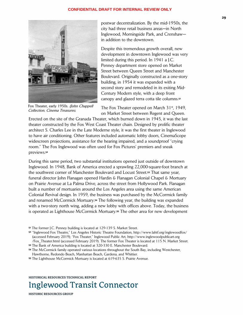
CONFIDENTIAL DRAFT FOR INTERNAL REVIEW ONLY
HISTORICAL RESOURCES TECHNICAL REPORT
Inglewood Transit Connector HISTORIC RESOURCES GROUP
29
postwar decentralization. By the mid-1950s, the city had three retail business areas—in North Inglewood, Morningside Park, and Crenshaw—in addition to the downtown.
Despite this tremendous growth overall, new development in downtown Inglewood was very limited during this period. In 1941 a J.C. Penney department store opened on Market Street between Queen Street and Manchester Boulevard. Originally constructed as a one-story building, in 1954 it was expanded with a second story and remodeled in its exiting Mid-Century Modern style, with a deep front canopy and glazed terra cotta tile columns.51
The Fox Theater opened on March 31st, 1949, on Market Street between Regent and Queen.
Erected on the site of the Granada Theater, which burned down in 1945, it was the last theater constructed by the Fox West Coast Theater chain. Designed by prolific theater architect S. Charles Lee in the Late Moderne style, it was the first theater in Inglewood to have air conditioning. Other features included automatic lobby doors, CinemaScope widescreen projections, assistance for the hearing impaired, and a soundproof “crying room.” The Fox Inglewood was often used for Fox Pictures’ premiers and sneak previews.52
During this same period, two substantial institutions opened just outside of downtown Inglewood. In 1948, Bank of America erected a sprawling 22,000-square-foot branch at the southwest corner of Manchester Boulevard and Locust Street.53 That same year, funeral director John Flanagan opened Hardin & Flanagan Colonial Chapel & Mortuary on Prairie Avenue at La Palma Drive, across the street from Hollywood Park. Flanagan built a number of mortuaries around the Los Angeles area using the same American Colonial Revival design. In 1959, the business was purchased by the McCormick family and renamed McCormick Mortuary.54 The following year, the building was expanded with a two-story north wing, adding a new lobby with offices above. Today, the business is operated as Lighthouse McCormick Mortuary.55 The other area for new development
51 The former J.C. Penney building is located at 129-139 S. Market Street. 52 “Inglewood Fox Theatre,” Los Angeles Historic Theatre Foundation, http://www.lahtf.org/inglewoodfox/
(accessed February 2019); “Fox Theater,” Inglewood Public Art, http://www.inglewoodpublicart.org /Fox_Theater.html (accessed February 2019). The former Fox Theater is located at 115 N. Market Street.
53 The Bank of America building is located at 320-330 E. Manchester Boulevard. 54 The McCormick family operated various locations throughout the South Bay, including Westchester,
Hawthorne, Redondo Beach, Manhattan Beach, Gardena, and Whittier. 55 The Lighthouse McCormick Mortuary is located at 619-635 S. Prairie Avenue.
Fox Theater, early 1950s. (John Chappell Collection, Cinema Treasures)

CONFIDENTIAL DRAFT FOR INTERNAL REVIEW ONLY
HISTORICAL RESOURCES TECHNICAL REPORT
Inglewood Transit Connector HISTORIC RESOURCES GROUP
30
during the postwar period was La Brea Avenue, a wide auto corridor which previously served as the western border of downtown Inglewood.56
Despite these examples of new construction in and around downtown during this period, the primacy of the city’s downtown as a commercial district was substantially diminished by increased competition from outlying commercial areas. The removal of the Market Street trolley line in 1957 added further stress to already struggling businesses. The city responded by adding municipally-owned off-street parking lots located throughout the district to draw car-dependent shoppers. The Chamber of
Commerce and Downtown Inglewood Retail Merchants Association coordinated to organize various promotional activities, as well as physical improvements like tree planting in the center strip and along sidewalks, which were in place by the early 1960s.57 However, these effects of these efforts were soon eclipsed by the continued loss of customers to new shopping malls in communities throughout Los Angeles. Inglewood considered, but ultimately rejected plants to build a mall of its own on a large parcel at Prairie and Manchester, a proposal largely defeated by the Market Street merchants. The site would instead become the home of the Forum.58
By the late 1960s, downtown Inglewood was in need of reinvention. To this end, the city contemplated a wholesale redevelopment scheme for the Market Street corridor that would expand and remodel existing stores, construct two high-rise office and apartment towers, introduce a landscaped arcade, and build a four-square block parking deck above shops to quadruple parking capacity.59 However, this plan would go unrealized. The United Bank of California at the southeast corner of Market and Regent
56 Also built during this period was a Sears department store at Manchester and Hillcrest boulevards. Opened in 1947, this was an early indicator that the future of retail in Inglewood would not be downtown. Sears was demolished in 1993 and replaced by a Vons supermarket.
57 “Downtown Center of Many Activities,” Los Angeles Times, March 18, 1962. 58 “The Changing Face of South Bay: Downtowns,” Los Angeles Times, January 4, 1987. 59 “$11 Million Center Assured in Inglewood,” Los Angeles Times, March 31, 1968.
Hardin & Flanagan Colonial Chapel and Mortuary (now Lighthouse McCormick Mortuary), c. 1950. (Tichnor Brothers Collection, Boston Public Library)

CONFIDENTIAL DRAFT FOR INTERNAL REVIEW ONLY
HISTORICAL RESOURCES TECHNICAL REPORT
Inglewood Transit Connector HISTORIC RESOURCES GROUP
31
streets would be the first new structure to be added to the Market Street corridor in nearly two decades, replacing several early 20th-century commercial buildings.60 Constructed in 1967 in the Late Modern style, it was joined nine years later by a stand-alone drive-thru automated teller building situated across Regent from the bank. Both buildings are believed to have been designed by Los Angeles modernist Richard Dorman.61
Beyond Downtown
In the late 1960s, nationally prominent businessman Jack Kent Cooke selected the site of a former golf course at the southeast corner of Prairie Avenue and Manchester Boulevard to erect a new venue for his three professional sports franchises: the Los Angeles Lakers NBA basketball team, the Los Angeles Kings NHL hockey team, and the short-lived Los Angeles Wolves professional soccer team. The Forum, a multi-purpose indoor arena, was designed by the prominent Los Angeles architectural firm Charles Luckman & Associates and completed in 1967.62 Designed in the New Formalist architectural style, it was intended as a modern and highly-stylized version of the Coliseum of ancient Rome. Nicknamed “the Fabulous Forum,” it would host tennis
60 The former United Bank of California is located at 158-170 N. Market Street. 61 Although an original building permit for the 1967 bank building is not available from the City of
Inglewood, the permit for the similarly-styled drive-thru automated teller building lists Richard Dorman as its architect.
62 The Forum is located at 3900 W. Manchester Boulevard.
Market Street, looking north from Queen Street, 1955. (Alan Weeks, L.A. County Metropolitan Transportation Authority Library & Archive)

CONFIDENTIAL DRAFT FOR INTERNAL REVIEW ONLY
HISTORICAL RESOURCES TECHNICAL REPORT
Inglewood Transit Connector HISTORIC RESOURCES GROUP
32
matches, boxing matches, ice shows, rodeos, the circus, award shows, and political events. In 1972, the Forum was the site of the Lakers’ first NBA championship since moving to Los Angeles; five additional titles would follow in the 1980s. From the mid-1970s through the 1990s, the Forum would serve as the premier large-scale concert venue for the Los Angeles area, and would be influential in the birth of “arena rock.” During the 1984 Olympics, the Forum was the venue for men’s and women’s basketball.63
By the early 1970s, Market Street had turned into a virtual ghost town as shoppers abandoned the downtown business center for suburban malls, and key tenants like J.C. Penney closed their doors. In an effort to reinvigorate the core of the city, from 1971 to 1976 Inglewood spent about $50 million in local, county, and federal funds to erect a new civic center complex along La Brea Avenue, just one block west of downtown. This new complex combined City Hall, a courthouse, library, fire and police facilities, public health complex, and a major new parking garage onto a single super-block, surrounded by expanses of lawn and public art. As hoped, this new construction sparked a flurry of new commercial development in the larger In-Town Redevelopment Area64—bounded by Florence, Locust, Manchester and Fir—the vast majority of which
63 “Forum,” National Register of Historic Places Form. Prepared by Historic Resources Group, April 29, 2014.
64 The In-Town Redevelopment Area was one of six redevelopment project areas adopted by the Inglewood Redevelopment Agency between 1970 and 1973.
Market Street, looking south from Regent Street, 1961. (Inglewood Public Library, Online Archive of California)

CONFIDENTIAL DRAFT FOR INTERNAL REVIEW ONLY
HISTORICAL RESOURCES TECHNICAL REPORT
Inglewood Transit Connector HISTORIC RESOURCES GROUP
33
was office space and not retail. Several residential projects were built at this time as well, most notably the 200-unit Inglewood Meadows housing complex on Locust Street, just east of downtown.65
While these projects brought large numbers of people into the vicinity of Market Street, their presence did not raise the corridor’s fortunes, and the vitality of the downtown business district continued to wain into the 1980s. In October 1986, Market Street merchants brought downtown business activity to halt as they closed their shops and picketed in a city-owned parking lot in a last-ditch effort to save it from redevelopment. The parking lot at La Brea Avenue and Queen Street provided 80 metered parking spaces which local shopkeepers saw as critical to continued viability of the downtown business district, which was already suffering from a severe parking shortage. Ultimately, however, the protests were unsuccessful, and the parking lot was soon replaced by a five-story office building.66 Yet another sign of downtown’s economic decline, the Fox Theater, then owned by the Mann theater chain, closed its doors in 1988.
Since the late-1970s, at least four City-sponsored revitalization programs have focused on improving Market Street’s commercial viability, introducing street landscaping and furniture as well as façade improvements to the existing buildings. Efforts have included a façade improvement program designed by architectural firm Kahn, Kappe, Lotery, Boccato (1979); a $250,000 façade improvement program, including signs and awnings (1984); a California Main Street Community Project (1990s); and the Market Street Renaissance program (2000). However, despite these efforts, Market Street has largely remained an underutilized asset.
Inglewood Today & Tomorrow
In 1994, Hollywood Park underwent a $100 million expansion into Hollywood Park Casino, which extended the facility’s economic viability. However, in May of 2013, it was announced that the Hollywood Park racetrack would be closing at the end of the
65 Dean Murphy and Michele L. Norris, “Government Money Becomes Urban Lifeblood: Innovation and Optimism Thrive on Public Funds in Inglewood, San Pedro,” Los Angeles Times, January 4, 1987.
66 “Merchants Protest Proposal to Build on Parking Lot,” Los Angeles Times, October 16, 1986.
The Forum under construction, with Jack Kent Cooke and Charles Luckman, 1967. (Herald Examiner Collection, LAPL)

CONFIDENTIAL DRAFT FOR INTERNAL REVIEW ONLY
HISTORICAL RESOURCES TECHNICAL REPORT
Inglewood Transit Connector HISTORIC RESOURCES GROUP
34
fall racing season. In 2015, the Inglewood City Council approved a plan to build an 70,000-seat football stadium on the site in anticipation of the St. Louis Rams moving back to Los Angeles. The Inglewood mayor was on-hand to witness the demolition by explosives of the massive grandstand.
The Forum remained the home of the Lakers and Kings until 1999, when both teams relocated to the newly-constructed Staples Center in downtown Los Angeles. Beginning in 2012, the Forum underwent a $50 million renovation, reopening in 2014. Later that year, the Forum was listed in the National Register of Historic Places. The venue is inextricably tied to the identity of the City of Inglewood, which adopted the moniker “City of Champions.” The Forum is slated to host the gymnastics events for the 2028 Summer Olympics.
Over the past decade, the City of Inglewood has been acquiring select parcels throughout the city for redevelopment, including along Market Street. Various planning studies have been conducted to develop standards for transit-oriented development, mixed-use development, and parking, with the goal of revitalizing downtown Inglewood. Local advocacy organization the Inglewood Historic Preservation Alliance (IHPA, formerly the Inglewood Historic Site Preservation Committee) continues to work toward the protection of the city’s historic structures and places of interest, including the Fox Theatre, which was successfully listed in the National Register of Historic Places in 2013.67 Currently, the City of Inglewood is utilizing The New Downtown and Fairview Heights Transit Oriented Development Plan and Design Guidelines, adopted November 1st, 2016, as the controlling document for future activity along Market Street.
On January 12th, 2016, the NFL voted to move the St. Louis Rams back to Los Angeles, with the San Diego Chargers to follow. In October 2016, the last part of the former racetrack, the Casino, was demolished and a new Hollywood Park Casino was opened next door. The new Los Angeles Stadium at Hollywood Park is currently under construction. When completed in 2020, it will be the new home of the NFL’s Los Angeles Rams and Los Angeles Chargers. The Los Angeles Stadium is slated to host Super Bowl LVI in 2022, the College Football National Championship in 2023, and the opening and closing ceremonies and soccer events for the 2028 Summer Olympics.
67 Anne Cheeck La Rose, “Inglewood Fox Theatre: Bringing Back the Inglewood Fox Theatre,” Los Angeles Historic Theatre Foundation, http://www.lahtf.org/inglewoodfox/ (accessed February 2019).
CONFIDENTIAL DRAFT FOR INTERNAL REVIEW ONLY
HISTORICAL RESOURCES TECHNICAL REPORT
Inglewood Transit Connector HISTORIC RESOURCES GROUP
35
5.2 Selected Chronology
Pre-History
3,500 BP
The Tongva occupy the area now encompassed by the Los Angeles basin, San Fernando Valley, San Gabriel Valley, San Bernardino Valley, and the local California coastline.
Spanish Colonial Period
1542 Spanish explorer Juan Rodriguez Cabrillo makes the first documented European contact with the native Tongva people.
1769 The Portolá expedition passes through present-day downtown Los Angeles, encountering the native people from the village of Yang-na.
1771 On September 8th, Spanish colonists establish Mission San Gabriel, the fourth of California’s Spanish missions.
1778 El Pueblo de Los Angeles is officially founded under the Spanish Laws of the Indies on September 4th.
Mexican Period
1821 Mexico wins its independence from Spain and Alta California becomes a territory of the new Mexican Republic.
1834 The California Missions are secularized by the Mexican government, and mission lands are confiscated for distribution in large land grants called ranchos.
Ygnacio Machado builds the Centinela Adobe, now considered the “birthplace of Inglewood.”
1837 The Machado family is granted official title of the area around Centinela Springs as the 2,219-acre Rancho Aguaje de la Centinela.
The Ávila family is granted the 22,458-acre Rancho Sausal Redondo, encompassing much of what is now the South Bay region of Los Angeles County.
1845 Bruno Ygnacio Ávila acquires Rancho Aguaje de la Centinela from the Machados in exchange for a small tract in the Pueblo de Los Ángeles for.
American Period
1846 United States troops begin occupying Alta California.
1848 The signing of the Treaty of Guadalupe Hidalgo on February 2nd cedes the California territory to the United States and ends the Mexican-American War.
1850 Los Angeles incorporates as an American city on April 4th.
California is admitted to the Union as its 31st state.

CONFIDENTIAL DRAFT FOR INTERNAL REVIEW ONLY
HISTORICAL RESOURCES TECHNICAL REPORT
Inglewood Transit Connector HISTORIC RESOURCES GROUP
36 1857 Bruno Ávila loses Rancho Aguaje de la Centinela through foreclosure.
1860 Rancho Aguaje de la Centinela is acquired by Scotsman Sir Robert Burnett.
1868 The heirs of Antonio Ávila are forced to sell Rancho Sausal Redondo to pay probate costs.
1872 Burnett acquires Rancho Sausal Redondo, combining his total land holdings of some 25,000 acres into the Centinela Ranch, encompassing the present-day communities of Playa del Rey, El Segundo, Manhattan Beach, Hermosa Beach, Redondo Beach, Westchester, Inglewood, Hawthorne, and Lawndale.
1873 Burnett leases his property to Daniel and Catherine Freeman.
1885 Daniel Freeman officially acquires Burnett’s property and names it Inglewood.
1887 Freeman sells some 11,000 acres of his ranch to the Centinela-Inglewood Land Company for development.
Inglewood Townsite
1888 The townsite of Inglewood is platted by the Centinela-Inglewood Land Company.
The California Central Railway completes a line to Redondo Beach.
Freeman erects a large mansion in Inglewood.
1889 Freeman builds a land office on the grounds of the Centinela Adobe.
1905 A group of local businessmen forms the Inglewood Park Cemetery Association.
1907 The Romanesque-style Grace Chapel is erected at Inglewood Park Cemetery.
City of Inglewood
1908 The City of Inglewood is incorporated on February 14th.
1914 Holy Faith Episcopal Church, designed by nationally renowned architect Philip Frohman, is officially consecrated.
1915 The Neoclassical-style Inglewood Mausoleum at the Inglewood Park Cemetery is completed.
1920 On the evening of June 21st, the Los Angeles Basin is rattled by an estimated 5.0 earthquake centered near Inglewood.
1927 The People’s Federal Building & Loan Association erects a building at the northeast corner of Market Street and Manchester Boulevard.
The Bank of Inglewood building is erected at the northeast corner of Market and Queen streets.

CONFIDENTIAL DRAFT FOR INTERNAL REVIEW ONLY
HISTORICAL RESOURCES TECHNICAL REPORT
Inglewood Transit Connector HISTORIC RESOURCES GROUP
37 A new ornamental lighting system is installed along Market Street.
1928 The Professional Building is constructed at Market Street and Manchester Boulevard’s northwest corner.
1929 The stock market crashes in late October, ultimately leading to the Great Depression.
1933 On the evening of March 10th, a magnitude 6.4 earthquake strikes off the coast of Long Beach.
1937 Mines Field, west of Inglewood, is purchased by the City of Los Angeles to serve as its municipal airport.
1938 Hollywood Park thoroughbred racetrack opens just southeast of downtown Inglewood.
Wartime & Postwar Growth
1941 On December 7th, the U.S. naval base at Pearl Harbor is attacked by the Imperial Japanese Navy, leading to the United States’ entry into World War II.
A J.C. Penney department store opens in downtown Inglewood.
1945 The Granada Theater on Market Street burns down.
1947 Sears department store opens at Manchester and Hillcrest boulevards.
1948 Bank of America opens a large branch on Manchester Boulevard, just east of downtown Inglewood.
The Hardin & Flanagan Colonial Chapel and Mortuary (now Lighthouse McCormick Mortuary) opens on Prairie Avenue, across from Hollywood Park.
1949 On March 31st, the Fox Theater opens on Market Street on the site of the Granada Theater.
Los Angeles Airport is renamed Los Angeles International Airport.
Beyond Downtown
1957 The Market Street trolley line is removed.
1967 The United Bank of California becomes the first contemporary structure to be added to the Market Street corridor.
The Forum is built by prominent businessman Jack Kent Cooke as a venue for his three professional sports franchises in Los Angeles: the Lakers (basketball), Kings (hockey), and Wolves (soccer).
1972 The Forum is the site of the Lakers’ first NBA championship since moving to Los Angeles.

CONFIDENTIAL DRAFT FOR INTERNAL REVIEW ONLY
HISTORICAL RESOURCES TECHNICAL REPORT
Inglewood Transit Connector HISTORIC RESOURCES GROUP
38 1973 A new Inglewood Civic Center complex is constructed just west of downtown.
1984 The Forum is the venue for men’s and women’s basketball during the Summer Olympics.
1986 Market Street merchants picket to stop the loss of a parking lot at La Brea Avenue and Queen Street for new construction; the protest is unsuccessful.
1988 The Fox Theater, then owned by the Mann theater chain, closes its doors.
Inglewood Today & Tomorrow
1993 Sears is demolished and replaced by a Vons supermarket.
1994 Hollywood Park undergoes a $100 million expansion into Hollywood Park Casino.
1999 The Lakers and Kings leave the Forum for the newly-constructed Staples Center in downtown Los Angeles.
2013 It is announced that Hollywood Park racetrack will close at the end of the fall racing season.
The Fox Theatre is listed in the National Register of Historic Places.
2014 The Forum reopens after a $50 million renovation.
The Forum is listed in the National Register of Historic Places.
2015 The Inglewood City Council approves a plan to build an 70,000-seat football stadium on the Hollywood Park site.
2016 On January 12th, the NFL votes to move the St. Louis Rams back to Los Angeles, with the San Diego Chargers to follow.
The Hollywood Park casino is demolished, and a new casino opened next door.
2020 The Los Angeles Stadium at Hollywood Park, currently under construction, will open as the new home of the NFL’s Los Angeles Rams and Los Angeles Chargers.
2022 Los Angeles Stadium is scheduled to host Super Bowl LVI.
2023 Los Angeles Stadium will be the venue for the College Football National Championship.
2028 Los Angeles Stadium will host the opening and closing ceremonies for the Summer Olympics, as well as soccer events.
The Forum is slated to host the gymnastics events for the Summer Olympics.

CONFIDENTIAL DRAFT FOR INTERNAL REVIEW ONLY
HISTORICAL RESOURCES TECHNICAL REPORT
Inglewood Transit Connector HISTORIC RESOURCES GROUP
39 6.0 IDENTIFICATION OF HISTORICAL RESOURCES
6.1 Listed Historical Resources There are two (2) properties within the Project Area and/or Expanded Study Area that are listed in the National Register, and are therefore automatically listed in the California Register. As such, these properties are considered historical resources as defined by CEQA.
3900 W. Manchester Boulevard (The Forum)
This property, located at the southeast corner of Manchester Boulevard and Prairie Avenue, contains the Forum, a multi-purpose indoor arena, surrounded by an expansive surface parking lot. It was built by nationally prominent businessman Jack Kent Cooke as a venue for his three professional sports franchises: the Los Angeles Lakers NBA basketball team, the Los Angeles Kings NHL hockey team, and the short-lived Los Angeles Wolves professional soccer team. Completed in 1967, it was designed by prominent Los Angeles architectural firm Charles Luckman & Associates in the New Formalist style. From 2012 to 2014, it underwent an extensive historic renovation.
The Forum was listed in the National Register of Historic Places on September 24th, 2014 under Criterion C as an excellent example of a 1960s New Formalist-style arena building, and is therefore automatically listed in the California Register. As such, this property is a historical resource under CEQA.
115 N. Market Street (former Fox Theater)
This property, located on the west side of Market Street between Regent and Queen streets, contains a 12,090 sq. ft. neighborhood movie theater building. Originally constructed in 1949 for Fox West Coast Theaters, it was designed by prolific theater architect S. Charles Lee in the Late Moderne style. The building is currently unoccupied and its storefront windows and doors are boarded up.
In 2000, the property was assigned a status code of 3S (appears eligible for the National Register as an individual property through survey evaluation) under Criterion C as a very good example of a 1940s Late Moderne-style movie theater building in Inglewood. On January 14th, 2013, the Fox Theater was listed in the National Register of Historic Places, and is therefore automatically listed in the California Register. As such, this property is a historical resource under CEQA.
6.2 Previously Identified Historical Resources There are nine (9) properties within the Project Area and/or Expanded Study Area that have been previously identified as eligible for historic listing or designation through historic resources surveys, environmental review, or other efforts. Most notably, a previous historical resources survey of Market Street was conducted as part of the Inglewood Downtown District/Main Street Project Area Historic Design Guidelines

CONFIDENTIAL DRAFT FOR INTERNAL REVIEW ONLY
HISTORICAL RESOURCES TECHNICAL REPORT
Inglewood Transit Connector HISTORIC RESOURCES GROUP
40
project, completed by Lauren Weiss Bricker, PhD, Marion Mitchell-Wilson, and Janet L. Tearnen in 2000.68 Each of these properties has been re-examined and re-evaluated for its eligibility for listing in the National Register or California Register.
Of these previously identified historical resources, four (4) were re-evaluated as appearing eligible for listing in the National Register and/or California Register, and are therefore considered herein as historical resources for the purposes of CEQA. Five (5) were found to appear ineligible for historic listing due to substantial alteration. No historic districts have been previously identified within the Project Area and/or Expanded Study Area.69
302 E. Manchester Boulevard/200-204 S. Market Street (Cox Menswear)
This property, located at the southeast corner of Manchester Boulevard and Market Street, contains a two-story commercial retail building. Originally constructed in 1941, the building was designed in the Streamline Moderne style and was historically occupied by Scotty’s Men’s Shop. The building’s current tenant is Cox Menswear. In 2000, the property was assigned a status code of 3S (appears eligible for the National Register as an individual property through survey evaluation) under Criterion C as a good example of the Streamline Moderne style in Inglewood.
Historic Resources Group has re-examined this property for the purpose of this report, and finds that it appears to have been substantially altered over time. On the ground story, the existing stone veneer and projecting aluminum-frame display windows appear to be the result of a mid-century remodel, replacing all of the original retail storefronts and wall cladding along both street-facing façades. On the upper story, original fenestration has been replaced with vinyl sliders. Also, the neon sign that originally adorned the corner tower has been removed. Due to these alterations, the building no longer displays the characteristic features of the Streamline Moderne style, nor does it represent a comprehensive or wholesale stylistic remodel from a particular historic period. Thus, this building does not retain sufficient integrity to convey its significance as a good example of its architectural style, and therefore does not appear eligible for
68 This 2000 report included a historic resources survey of the Inglewood Downtown District/Main Street project area, which was bounded by La Brea Avenue to the west, Locust Street to the east, Florence Avenue to the north, and Hillcrest Boulevard to the south. The upper portion of this survey area includes the Market Street portion of the current Project Area/Expanded Study Area. The survey identified eight (8) individual properties within the current Project Area/Expanded Study Area as eligible for historic designation; no historic district was identified.
69 The New Downtown and Fairview Heights Transit Oriented Development Plan and Design Guidelines, adopted November 1, 2016, identifies Downtown Inglewood as “Historic Downtown.” However, this appears to refer to the area’s history as Inglewood’s original business district, and is not an evaluation of historic eligibility.

CONFIDENTIAL DRAFT FOR INTERNAL REVIEW ONLY
HISTORICAL RESOURCES TECHNICAL REPORT
Inglewood Transit Connector HISTORIC RESOURCES GROUP
41
listing in the National Register or the California Register. As such, it is not considered a historical resource herein for the purposes of CEQA.
320-330 E. Manchester Boulevard (Bank of America)
This property, located at the southwest corner of Manchester Boulevard and Locust Street, contains a 21,976 sq. ft. bank building and a rear surface parking lot.70 Originally constructed in 1948, the building was erected for Bank of America and designed in the Late Moderne style. Bank of America continues as its current tenant. The smaller adjacent building at 320 E. Manchester Boulevard was originally constructed in 1920 and remodeled as part of the Bank of America in 1954. In 2000, the property was assigned a status code of 3S (appears eligible for the National Register as an individual property through survey evaluation) under Criterion C as a good example of a 1940s PWA Moderne-style bank building in Inglewood.
Historic Resources Group has re-examined this property for the purpose of this report, and finds that it appears substantially unaltered since its original construction. The building retains the majority of its original exterior features, including its form and massing, exterior wall cladding, fenestration patterns, and decorative elements. The framing of the windows and doors may have been updated. However, the replacement material appears to be in keeping with what would have been in place historically, such that this change does not substantially diminish the building’s integrity. Other changes—including lighting, signage, and the addition (and subsequent removal) of an in-wall ATM—are minor in relation to the building’s overall appearance. The building remains largely intact and continues to display the characteristic features of a PWA Moderne bank building from the 1940s. Thus, this building retains sufficient integrity to convey its significance as a good example of its architectural style, and therefore appears eligible for listing in the California Register. As such, this property is considered a historical resource herein for the purposes of CEQA.
100 N. Market Street/307 E. Queen Street (former Bank of Inglewood)
This property, located at the northeast corner of Market and Queen streets, contains a two-story, 9,258 sq. ft. mixed-use commercial building constructed in 1927. The building was originally constructed for the Bank of Inglewood at a cost of $140,000. Designed by local architect William L. Campbell in the Mediterranean Revival style, the reinforced concrete building was the first steel frame business block in the city. The building was sold to Bank of America National Trust & Savings Association in 1936; in 1950 it became Southwest Bank. It now serves as a retail space occupied by Vajra Books & Gifts. In 2000, the property was assigned a status code of 3S (appears eligible for the National Register as an individual property through survey evaluation) under
70 The main bank building uses the address 330 E. Manchester Bl.; the smaller adjacent building is at 320.

CONFIDENTIAL DRAFT FOR INTERNAL REVIEW ONLY
HISTORICAL RESOURCES TECHNICAL REPORT
Inglewood Transit Connector HISTORIC RESOURCES GROUP
42
Criterion C as an excellent example of a 1920s Mediterranean Revival-style bank building in Inglewood.
Historic Resources Group has re-examined this property for the purpose of this report, and finds that it appears substantially unaltered since its original construction. The building retains the majority of its original exterior features, including its form and massing, roof material, exterior wall cladding, fenestration patterns, elaborated arched main entrance and ground-story windows, upper-story windows, and various decorative elements. Alterations—such as replaced front doors and the addition of tile cladding on the ground story—are minor in relation to the building’s overall appearance, and do not substantially diminish its integrity. The building remains highly intact and continues to display the characteristic features of a Mediterranean Revival bank building from the 1920s. Thus, this building retains sufficient integrity to convey its significance as a good example of its architectural style, and therefore appears eligible for listing in the National Register and the California Register. As such, this property is considered a historical resource herein for the purposes of CEQA.
124-126 N. Market Street
This property, located on the east side of Market Street between Regent and Queen streets, contains a two-story, 2,750 sq. ft. mixed-use commercial building constructed in 1920. In 2000, the property was assigned a status code of 5S1 (eligible for local listing); no reason for significance was provided.71
Historic Resources Group has re-examined this property for the purpose of this report, and finds that it appears to have been substantially altered over time. The building’s original retail storefronts have been replaced with floor-to-ceiling aluminum storefronts, thereby completely altering the ground story on the building’s only publicly-visible façade. On the upper story, original fenestration has been replaced with metal sliders. The building does not display the characteristic features of a particular architectural style and is not known to be the work of a master; it does not appear to be a notable example of its building type from a particular period; and it has no known important historic associations that would qualify it for historic listing or designation. Therefore, the building does not appear eligible for listing in the National Register or the California Register. As such, it is not considered a historical resource herein for the purposes of CEQA.
125 S. Market Street
This property, located on the west side of Market Street between Queen Street and Manchester Boulevard, contains a one-story commercial building constructed in 1938. The building is currently occupied by Basket Beauty Supply. In 2000, the property was
71 Note that Inglewood’s downtown survey was completed prior to the revision of the California Historical Resources Status Codes. These codes were updated and their definitions revised in August 2003.

CONFIDENTIAL DRAFT FOR INTERNAL REVIEW ONLY
HISTORICAL RESOURCES TECHNICAL REPORT
Inglewood Transit Connector HISTORIC RESOURCES GROUP
43
assigned a status code of 5S1 (eligible for local listing) under Criterion C as an intact example of a mid-century remodeled façade.
Historic Resources Group has re-examined this property for the purpose of this report, and finds that it has been substantially altered over time, including since its previous evaluation. The 2000 survey referred to this building as “among the more visually interesting” mid-century façade remodels along Market Street, noting a “metal pylon sign [that] juts above the building's parapet at a sufficient height and angle to be seen by the pedestrian” and “framed [display] cases that cantilever beyond their built-in bases.”72 None of these features remain extant. Alterations include the replacement of the exterior wall cladding on both stories, the replacement of all retail storefronts and entry doors, the addition of applied decorative features above the canopy, added light fixtures, and contemporary signage. Taken together, these alterations have completely transformed the building’s only publicly-visible façade, such that it no longer displays any elements of its original 1930s design, nor does it represent a comprehensive mid-century façade remodel. Thus, this building does not retain sufficient integrity to convey its significance as a good example of its architectural style, and therefore does not appear eligible for listing in the National Register or the California Register. As such, it is not considered a historical resource herein for the purposes of CEQA.
129-139 S. Market Street (former J.C. Penney)
This property, located on the west side of Market Street between Queen Street and Manchester Boulevard, contains a two-story, 62,583 sq. ft. commercial retail building which originally housed a J.C. Penney department store. The building was initially constructed as one story in 1941. In 1954, it was expanded with a second story and remodeled in the Mid-Century Modern style. It is currently occupied by Inglewood Marketplace. In 2000, the property was assigned a status code of 5S1 (eligible for local listing) under Criterion C as a good example of a 1950s Mid-Century Modern-style department store building.
Historic Resources Group has re-examined this property for the purpose of this report, and finds that it appears substantially unaltered since its 1950s remodel. The building retains the majority of its exterior features from this period, including its form and massing, exterior wall cladding, angled storefronts, recessed entry with terrazzo flooring, entry doors, canopy, upper-story ribbon windows, and applied decoration. Alterations—such as contemporary signage and the distinctive paint job—are minor in relation to the building’s overall appearance, and do not substantially diminish its integrity. The building remains highly intact and continues to display the characteristic features of a Mid-Century Modern department store building from the 1950s. Thus, this building retains sufficient integrity to convey its significance as a good example of its architectural style,
72 Bricker, 16.

CONFIDENTIAL DRAFT FOR INTERNAL REVIEW ONLY
HISTORICAL RESOURCES TECHNICAL REPORT
Inglewood Transit Connector HISTORIC RESOURCES GROUP
44
and therefore appears eligible for listing in the California Register. As such, this property is considered a historical resource herein for the purposes of CEQA.
132 S. Market Street
This property, located on the east side of Market Street between Queen Street and Manchester Boulevard, contains a two-story mixed-use commercial building constructed in 1925. The building is currently occupied by Smoove Fashion World. In 2000, the property was assigned a status code of 5S1 (eligible for local listing); no reason for significance was provided.
Historic Resources Group has re-examined this property for the purpose of this report, and finds that it appears to have been substantially altered over time. The building’s original retail storefront has been replaced with a floor-to-ceiling aluminum storefront, and brick veneer wall cladding and an awning have been added, thereby completely altering the building’s ground story. On the upper story, original fenestration has been replaced with metal or vinyl sliders. Some original decorative features remain on the upper story. However, overall the building does not display the characteristic features of a particular architectural style and is not known to be the work of a master; it does not appear to be a notable example of its building type from a particular period; and it has no known important historic associations that would qualify it for historic listing or designation. Therefore, the building does not appear eligible for listing in the National Register or the California Register. As such, it is not considered a historical resource herein for the purposes of CEQA.
150 S. Market Street (former People’s Federal Building & Loan Association)
This property, located at the northeast corner of Market Street and Manchester Boulevard, contains a two-story, 16,575 sq. ft. mixed-use commercial building. The building was originally constructed in 1927 as the People’s Federal Building & Loan Association. It was remodeled in the Late Modern style, likely sometime in the 1960s. It is currently occupied by World Hat & Boot Mart. In 2000, the property was assigned a status code of 5S1 (eligible for local listing) under Criterion C as a good example of a 1960s Late Modern-style commercial building.
Historic Resources Group has re-examined this property for the purpose of this report, and finds that it appears substantially unaltered since its 1960s remodel. The building retains the majority of its exterior features from this period, including its form and massing, exaggerated arches and elevated roof plate, exterior wall cladding, metal storefronts and entry doors, canopy, and upper-story fenestration. Alterations—such as contemporary signage and the replacement of the original entry doors with a display window—are minor in relation to the building’s overall appearance, and do not substantially diminish its integrity. The building remains largely intact and continues to display the characteristic features of a Late Modern commercial building from the 1960s. Thus, this building retains sufficient integrity to convey its significance as a good

CONFIDENTIAL DRAFT FOR INTERNAL REVIEW ONLY
HISTORICAL RESOURCES TECHNICAL REPORT
Inglewood Transit Connector HISTORIC RESOURCES GROUP
45
example of its architectural style, and therefore appears eligible for listing in the California Register. As such, this property is considered a historical resource herein for the purposes of CEQA.
333 E. Nutwood Street
This property, located at the northwest corner of Locust and Nutwood streets, contains a one-story commercial office building constructed in 1940. The building is currently occupied by Anphon Medical Center. In 2000, the property was assigned a status code of 5S1 (eligible for local listing); no reason for significance was provided.
Historic Resources Group has re-examined this property for the purpose of this report, and finds that it appears to have been substantially altered over time. The building’s exterior wall cladding has been replaced with rough-textured stucco, and exaggerated stucco-clad window surrounds have been added throughout. These changes are incompatible with the building’s American Colonial Revival style, and thereby substantially alter the building’s overall appearance. The building is no longer a good example of its architectural style and is not known to be the work of a master; it does not appear to be a notable example of its building type from a particular period; and it has no known important historic associations that would qualify it for historic listing or designation. Therefore, the building does not appear eligible for listing in the National Register or the California Register. As such, it is not considered a historical resource herein for the purposes of CEQA.
6.3 Newly Identified Historical Resources Detailed field surveys of the Project Area and Expanded Study Area were conducted on June 4th, 2018 and February 21st, 2019. These field surveys were supplemented by property-specific and contextual research to identify additional properties that are eligible for listing or designation and therefore may be considered historical resources under CEQA. Through this process, five (5) additional properties were evaluated as appearing eligible for listing in the National Register and/or California Register, and are therefore considered herein as historical resources for the purposes of CEQA. No historic districts were identified within the Project Area and/or Expanded Study Area.
260 N. Locust Street (Holy Faith Episcopal Church)
This property, located at the southeast corner of Locust Street and Grace Avenue, contains the Holy Faith Episcopal Church complex. The congregation was first established in 1911, with services held in the Inglewood Masonic Hall. In 1912, funds were donated to erect a complex consisting of a church, a rectory (the dwelling to the south), and parish hall (now a school at the rear). The complex of buildings was designed by architect Philip Frohman, would go on to become nationally renowned, particularly for his work on the National Cathedral in Washington, D.C. The church building was officially consecrated on November 8th, 1914. It lost its original bell tower

CONFIDENTIAL DRAFT FOR INTERNAL REVIEW ONLY
HISTORICAL RESOURCES TECHNICAL REPORT
Inglewood Transit Connector HISTORIC RESOURCES GROUP
46
in the 1933 Long Beach Earthquake, but continued to be improved throughout the 1930s, with the Stations of the Cross, imported from Italy; the pulpit, lectern and choir stalls from England; and the reredos carved and imported from Bavaria. The stained-glass windows were crafted by Judson Studios in Highland Park. Due to its growing congregation, in the late 1950s architect Philip Frohman returned to design an addition to the church building.73 The church was extended to the west and an interior balcony added, doubling its capacity from 200 to 400. The newly expanded church building was dedicated in 1959. The parish hall, which now serves as a school, has been expanded multiple times from the 1950s to the 1980s, now extending nearly the full width of the lot. The rectory appears largely intact, with some windows replaced. In 2000, the property was assigned a status code of 4S1 (may become eligible for the National Register when it becomes old enough).74
Historic Resources Group has re-examined this property for the purpose of this report, and finds that it appears substantially intact, including the main church building, the rectory, and the school. Character-defining features of the church building include its double-cruciform plan; gabled roofs with capped parapets and decorative crosses; copper steeple; stucco exterior walls with cast-stone stepped buttresses; base with cast-stone molding; pointed-arch openings with decorative cast-stone surrounds; leaded stained-glass windows; cast-stone Gothic tracery and quoining; wood plank doors with exposed iron hardware; metal scuppers and downspouts; and decorative wrought-iron wall sconces. The church expansion was designed by the original architect to respect and complement the original church—with features such as wood entry doors and stained-glass windows retained and incorporated into the expanded design—and thus is considered to have acquired significance in its own right. Similarly, additions to the school building are compatible with yet differentiated from the original extent, which remains evident. Thus, the property as a whole retains sufficient integrity to convey its significance as an excellent and rare early 20th-century religious complex in Inglewood. Additionally, the church building appears to be an outstanding example of Late Gothic Revival architecture, representing the work of a nationally-significant architect. Therefore, the property appears eligible for listing in the National Register and the California Register under Criterion A/1 as early institutional development in Inglewood, and Criterion C/3 for its architectural merit. As such, it is considered a historical resource herein for the purposes of CEQA.
73 Bricker, 8 (Database Master Report, appendix to the Inglewood Downtown District/Main Street Project Area Historic Design Guidelines).
74 It is unclear why this status code was assigned, as it was typically reserved for properties that were less than 50 years of age at the time of evaluation.
CONFIDENTIAL DRAFT FOR INTERNAL REVIEW ONLY
HISTORICAL RESOURCES TECHNICAL REPORT
Inglewood Transit Connector HISTORIC RESOURCES GROUP
47
158-170 N. Market Street (former United Bank of California)
This property, located at the southeast corner of Market and Regent streets, contains a 9,000 sq. ft. branch bank building and rear surface parking lot. Originally constructed in 1967 for United Bank of California, it was designed by noted Los Angeles architect Richard Dorman in the Late Modern style.75 Richard Dorman was a prolific modernist architect and designer who worked throughout the Los Angeles region from the 1950s through the 1970s. Over the course of his career he designed dozens of high-end residences, as well as various commercial and institutional buildings such as offices, churches, and banks. In 1976, the bank added a similarly-designed drive-thru automated teller building across Regent Street to the north, also designed by Dorman.76 The building is currently occupied by Broadway Federal Bank. In 2000, the property was assigned a status code of 6Z (appears ineligible for the National Register).
Historic Resources Group has re-examined this property for the purpose of this report, and finds that it appears substantially unaltered since its original construction. Character-defining features include its cruciform roof plan; projecting trapezoidal volumes; battered walls; heavy wood beams; smooth exterior surfaces of brick and stucco; and large expanses of tinted glass. Alterations—such as contemporary signage, and the addition of an in-wall ATM with an access ramp and projecting canopy—are minor in relation to the building’s overall appearance, and do not substantially diminish its integrity. At the time of its previous evaluation, the bank building was well below the 50-year age threshold used in standard preservation practice for evaluating eligibility for historic designation.77 Additionally, since the 2000 survey there has been substantial new scholarship on the built environment of the mid-20th century, with new historic contexts developed to provide guidance for evaluating such properties. In light of this new scholarship, this property appears to be significant as a 1960s Late Modern-style bank building in Inglewood, representing the work of a noted architect. It remains highly intact and thus retains sufficient integrity to convey its significance as a good example of its architectural style. Therefore, the property appears eligible for listing in the California Register under Criterion 3 for its architectural merit. As such, it is considered a historical resource herein for the purposes of CEQA.
149-155 S. Market Street/231-239 E. Manchester Boulevard (Professional Building)
This property, located at the northwest corner of Market Street and Manchester Boulevard, contains a two-story, 6,000 sq. ft. mixed-use commercial building.
75 Although an original building permit for the 1967 bank building is not available from the City of Inglewood, the permit for the similarly-styled drive-thru automated teller building across the street lists Richard Dorman as its architect.
76 Because the drive-thru automated teller building is situated across the street and was added nine years later, it is not considered part of the bank building.
77 According to National Park Service guidance, 50 years is a general estimate of time needed to develop sufficient historical perspective to evaluate historic significance.

CONFIDENTIAL DRAFT FOR INTERNAL REVIEW ONLY
HISTORICAL RESOURCES TECHNICAL REPORT
Inglewood Transit Connector HISTORIC RESOURCES GROUP
48
Constructed in 1928 as the Professional Building, it was designed in the Spanish Colonial Revival style with cast-stone Churrigueresque details. In 2000, the property was assigned a status code of 4S7 (may become eligible for the National Register when integrity is restored).
Historic Resources Group has re-examined this property for the purpose of this report, and finds that despite alterations on the ground story, the upper story appears substantially unaltered since its original construction. The building retains the majority of its original exterior features, including its red clay tile shed roofs with exposed rafter tails; smooth stucco exterior cladding; wood tripartite upper-story windows; decorative cast-stone details at the roofline; and a canopy with decorative wrought-iron supports at the secondary entrance. Alterations—including replacement of ground-story storefronts and entry doors—do somewhat diminish the building’s integrity. However, overall the building remains largely intact and continues to display the characteristic features of a Spanish Colonial Revival commercial building from the 1920s. Thus, it retains sufficient integrity to convey its significance as a good example of its architectural style, and therefore appears eligible for listing in the California Register under Criterion 3 for its architectural merit. As such, this property is considered a historical resource herein for the purposes of CEQA.
619-635 S. Prairie Avenue (Lighthouse McCormick Mortuary)
This property, located at the northwest corner of Prairie Avenue and La Palma Drive, contains a two-story, 9,352 sq. ft. chapel and mortuary building. Designed in the American Colonial Revival style, the building was initially constructed in 1948 as the Hardin & Flanagan Colonial Chapel & Mortuary. In 1959, the business was acquired by the McCormick family and renamed McCormick Mortuary. Around 1960, the building was expanded with a new two-story wing to the north. It is currently operated as Lighthouse McCormick Mortuary.
Historic Resources Group has examined this property for the purpose of this report, and finds that it appears substantially unaltered since its 1960s expansion. The building retains the majority of its exterior features from this period, including its form and massing; hipped and gable roofs with boxed eaves; decorative cornice with return; two-story porticos with slender full-height columns; stucco and wood clapboard exterior cladding; fluted pilasters; divided-light double-hung wood windows with louvred wood shutters; wood paneled doors; round and rounded-arch openings; elaborated entrances including fanlights, sidelights, and decorative wood surrounds; and hanging lanterns. Alterations—such as replacement of an original window with a vinyl slider—are minor in relation to the building’s overall appearance, and do not substantially diminish its integrity. The mortuary’s expansion was designed to respect and complement that of the original chapel and office, and thus is considered to have acquired significance in its own right. The building remains highly intact and continues to display the characteristic features of a mid-20th century American Colonial Revival mortuary building. Thus, it

CONFIDENTIAL DRAFT FOR INTERNAL REVIEW ONLY
HISTORICAL RESOURCES TECHNICAL REPORT
Inglewood Transit Connector HISTORIC RESOURCES GROUP
49
retains sufficient integrity to convey its significance as an excellent example of its architectural style, and therefore appears eligible for listing in the California Register under Criterion 3 for its architectural merit. As such, this property is considered a historical resource herein for the purposes of CEQA.
720 E. Florence Avenue (Inglewood Park Cemetery) 78
This property, located at the northeast corner of Manchester Boulevard and Prairie Avenue, contains a large cemetery. In 1905, a group of local businessmen formed the Inglewood Park Cemetery Association and acquired a large plot of land just east of what would become downtown Inglewood. In 1907, the cemetery erected the Romanesque-style Grace Chapel, a three-quarters replica of a church in Edinburgh, Scotland. In these early days, funerals often arriving by rail from Los Angeles in a private funeral car; portions of the original railroad waiting station have been incorporated into the main entrance. The Neoclassical-style Inglewood Mausoleum was completed in 1915 and was the first community mausoleum in the State of California. The Mausoleum of the Golden West was built over several decades from the 1930s to the 1960s and features stained-glass representations of early California by Judson Studios. Various notable persons have been laid to rest at Inglewood Park Cemetery, including some of the South Bay region’s earliest settlers, a number of Civil War veterans, and famous figures such as former Los Angeles Mayor Tom Bradley, Chet Baker, Ray Charles, Ella Fitzgerald, Etta James, boxer Sugar Ray Robinson, and architect Paul Williams. At the time of this report, both Grace Chapel and the Inglewood Mausoleum were undergoing renovation.
Historic Resources Group has examined this property for the purpose of this report, and finds that it has evolved over time but that it remains substantially intact. The property appears to retain the majority of its original features, such as its overall form and configuration, landscape design, and main entrance, as well as multiple excellent examples of cemetery architecture, including Grace Chapel, Inglewood Mausoleum, and Mausoleum of the Golden West.79 Alterations—such as the addition of more recent buildings—do not substantially diminish the integrity of the property overall. Thus, the property as a whole retains sufficient integrity to convey its significance as an excellent
78 The parcel at the northeast corner of Manchester Boulevard and Prairie Avenue is included in the Expanded Study Area because it fronts the alignment right-of-way. This parcel has no address and contains only a small portion of the Inglewood Park Cemetery property. The vast majority of the cemetery occupies the adjacent parcel at 720 E. Florence Avenue (APN 4012031027). In the interest of being inclusive, the Inglewood Park Cemetery has been included in the Expanded Study Area for the purpose of this Project. While the cemetery extends several blocks north of the Project Area to Florence Avenue, project impacts would only be expected in the southwesternmost portion of the property.
79 Due to the size and complexity of this property, identification of contributing and non-contributing features was outside the scope of this report.

CONFIDENTIAL DRAFT FOR INTERNAL REVIEW ONLY
HISTORICAL RESOURCES TECHNICAL REPORT
Inglewood Transit Connector HISTORIC RESOURCES GROUP
50
and rare early 20th-century cemetery in Inglewood. Additionally, Grace Chapel, Inglewood Mausoleum, and Mausoleum of the Golden West appear to be excellent examples of their architectural style. Therefore, the property appears eligible for listing in the National Register80 and the California Register under Criterion A/1 as early institutional development in Inglewood, and Criterion C/3 and for the quality of its architectural and landscape design. As such, this property is considered a historical resource herein for the purposes of CEQA.
6.4 Summary of Historical Resources To summarize, eleven (11) historical resources have been identified in the Project Area and/or Expanded Study Area for the Locally Preferred Alternative and/or the Market Street Station Alternative. Under the Locally Preferred Alternative, there are ten (10) identified historical resources, with one (1) additional historical resource under the Market Street Station Alternative. Of these, two (2) are listed in the National Register and the California Register; four (4) were previously identified as historic through historic resources surveys, environmental review, or other efforts, and have been re-evaluated as appearing eligible for listing in the National Register and/or California Register; and five (5) were identified through this process and evaluated as appearing eligible for listing in the National Register and/or California Register. All of these properties are considered herein as historical resources for the purposes of CEQA. Therefore, potential impacts of the Project to these properties are analyzed in this report. [See Figure 6. Map of Historical Resources (Locally Preferred Alternative) and Figure 7. Map of Historical Resources (Market Street Station Alternative).]
[For field photographs of these historical resources and their immediate surroundings, taken June 4th, 2018 and February 21st, 2019, see Appendix A.]
Summary List of Historical Resources
ADDRESS APN DATE NAME DESCRIPTION CURRENT
EVALUATION
260 N Locust St 4015026039 1914 Holy Faith Episcopal Church
Religious complex (church, rectory and school)
Appears eligible for listing in NR & CR
320‐330 E Manchester Bl
4021013018 1948 Bank of America Branch bank, rear parking lot
Appears eligible for listing in CR
80 Based upon its age, this property appears to meet National Register Criterion Consideration D for cemeteries.

CONFIDENTIAL DRAFT FOR INTERNAL REVIEW ONLY
HISTORICAL RESOURCES TECHNICAL REPORT
Inglewood Transit Connector HISTORIC RESOURCES GROUP
51
ADDRESS APN DATE NAME DESCRIPTION CURRENT
EVALUATION
3900 W Manchester Bl 4025001002 1967 The Forum Multi‐purpose indoor arena, surrounding parking lot
Listed in NR and CR
100 N Market St/307 E Queen St
4021007024 1927 Former Bank of Inglewood (now Vajra Books & Gifts)
Two‐story mixed‐use commercial building
Appears eligible for listing in NR & CR
115 N Market St 4021008006 1949 Former Fox Theater Neighborhood movie theater
Listed in NR and CR
158‐170 N Market St 4021007012 1967 Former United Bank of California (now Broadway Federal Bank)
Branch bank, rear parking lot
Appears eligible for listing in CR
129‐139 S Market St 4021009031 1941, addition and remodel 1954
Former J.C. Penney (now Inglewood Marketplace)
Two‐story retail commercial building
Appears eligible for listing in CR
149‐155 S Market St/231‐239 E Manchester Bl
4021009017 1928 Professional Building Two‐story mixed‐use commercial building
Appears eligible for listing in CR
150 S Market St 4021010015 1927, remodel c. 1965
Former People’s Federal Building & Loan Association (now World Hat & Boot Mart)
Two‐story mixed‐use commercial building
Appears eligible for listing in CR
619‐635 S Prairie Ave 4021038027 1948, addition c. 1960
Lighthouse McCormick Mortuary (former Hardin & Flanagan Colonial Chapel and Mortuary)
Two‐story chapel and mortuary building
Appears eligible for listing in CR
720 E Florence Ave81 4012031930 1905 Inglewood Park Cemetery
Cemetery Appears eligible for listing in NR & CR
81 The parcel situated within the Expanded Study Area (APN 4012031930) has no address and contains only a small portion of the Inglewood Park Cemetery property. The vast majority of the cemetery occupies the adjacent parcel at 720 E Florence Avenue (APN 4012031027).

CONFIDENTIAL DRAFT FOR INTERNAL REVIEW ONLY
HISTORICAL RESOURCES TECHNICAL REPORT
Inglewood Transit Connector HISTORIC RESOURCES GROUP
52 Figure 6. MAP OF HISTORICAL RESOURCES (LOCALLY PREFERRED ALTERNATIVE)

CONFIDENTIAL DRAFT FOR INTERNAL REVIEW ONLY
HISTORICAL RESOURCES TECHNICAL REPORT
Inglewood Transit Connector HISTORIC RESOURCES GROUP
53 Figure 7. MAP OF HISTORICAL RESOURCES (MARKET STREET STATION ALTERNATIVE)
CONFIDENTIAL DRAFT FOR INTERNAL REVIEW ONLY
HISTORICAL RESOURCES TECHNICAL REPORT
Inglewood Transit Connector HISTORIC RESOURCES GROUP
54 7.0 POTENTIAL IMPACTS
7.1 Framework for Analysis Guidelines for Implementation of CEQA are codified at Title 14 California Code of Regulations section 15000 et seq. The CEQA Guidelines state that “a project that may cause a substantial adverse change in the significance of a historical resource is a project that may have a significant effect on the environment.”82 A “substantial adverse change in the significance of a historical resource” means the physical demolition, destruction, relocation, or alteration of the resource or its immediate surroundings such that the significance of a historical resource would be materially impaired.83
The CEQA Guidelines go on to state that “[t]he significance of a historical resource is materially impaired when a project…”[d]emolishes or materially alters in an adverse manner those physical characteristics of a historical resource that convey its historical significance and that justify its inclusion in, or eligibility for, inclusion in the California Register of Historical Resources… local register of historical resources… or its identification in a historical resources survey.”84
Thus, an evaluation of project impacts under CEQA requires a two-part inquiry: (1) a determination of whether the project site contains or is adjacent to a historical resource, and if so, (2) a determination of whether the proposed project will result in a substantial adverse change in the significance of the historical resource.
7.2 Analysis of Direct Impacts This section analyzes the potential for the Project to have a direct impact on any historical resources under CEQA. As discussed above, the significance of a historical resource is materially impaired, and constitutes a substantial adverse change in the significance of that historical resource, if the project would materially alter in an adverse manner those physical characteristics of the resource or its immediate surroundings that convey its historical significance and justify its inclusion in the California Register, local register, or historical resource survey. The significance of a historical resource may be materially impaired through project impacts both direct and indirect. Thus, the potential for this Project to impact a historical resource, either directly or indirectly, is analyzed.
As described above, much of the Project will be constructed within the public right-of-way,85 including the elevated APM guideway set on single or dual support columns, and five APM Stations. However, several Project components will be constructed on parcels immediately adjacent to the public right-of-way. Under the Locally Preferred Alternative,
82 CEQA Guidelines, Section 15064.5(b). 83 Ibid., Section 15064.5(b)(1). 84 Ibid., Section 15064.5(b)(2). 85 The public right-of-way extends to the front property line on each side of the street, including the
roadway and sidewalks.
CONFIDENTIAL DRAFT FOR INTERNAL REVIEW ONLY
HISTORICAL RESOURCES TECHNICAL REPORT
Inglewood Transit Connector HISTORIC RESOURCES GROUP
55
these include the vertical circulation elements for each of the five APM stations; the landing for a pedestrian bridge; the Maintenance & Storage Facility; the Intermodal Transportation Facility; up to four Traction Power Substations; and the widening of Prairie Avenue. Under the Market Street Station Alternative, these also include the alternate location for the Market Street Station, and an alternate location for the Market Street Station pedestrian bridge. Thus, the Project does have the potential to directly impact historical resources.
This report has identified two (2) historical resources within the Project Area for the Locally Preferred Alternative and the Market Street Station Alternative that could be directly impacted by the Project. Potential impacts to each of these resources are described below.
3900 W. Manchester Boulevard (The Forum)
The Forum property is located within the Project Area for the Locally Preferred Alternative and the Market Street Station Alternative, situated along the east side of the APM alignment as it travels north/south along Prairie Avenue. As described above, the Project will construct an elevated APM guideway set on support columns within the public right-of-way of Prairie Avenue between Manchester and Century boulevards. Additionally, Prairie Avenue will be widened to the east, encroaching into the Forum property along its western boundary. With this street widening, additional Project components will be constructed on what is now the Forum parking lot, including the support columns east of the APM guideway; vertical circulation elements for the Forum Station; and possibly a Traction Power Substation.
The Project will not physically alter the Forum building in any way. The building will remain in its original location and will retain all of its significant character-defining features and materials. However, the Project will alter a portion of the Forum’s surface parking lot, which is identified as a character-defining feature in the National Register nomination. The Project will take approximately 20 to 25 feet of the parking lot along its western edge for the widening of Prairie Avenue between Nutwood and Kelso streets, thereby changing the original dimensions of the site. Despite this alteration, the parking lot will retain its overall character as an expansive, on-grade, asphalt-paved parking area surrounding the Forum building on all sides.
Additionally, the Project includes new construction on the Forum site, including support columns for the APM guideway; and vertical circulation elements such as escalators, elevators, stairs for the Forum Station. The Project may also construct a 3,000-square-foot Traction Power Substation at the southwest corner of the Forum site. All of these new features will be constructed within or immediately adjacent to the pubic right-of-way of the newly relocated sidewalk on the east side of Prairie Avenue. Proportionally, the new construction will be much smaller in scale as compared to the Forum building and to the parking lot itself, both of which are quite massive. These new features will be situated along the property’s western edge, and thus there will be a substantial physical

CONFIDENTIAL DRAFT FOR INTERNAL REVIEW ONLY
HISTORICAL RESOURCES TECHNICAL REPORT
Inglewood Transit Connector HISTORIC RESOURCES GROUP
56
distance between the new construction and the Forum building itself. Thus, the Project will not alter the relationship between the Forum building and its immediate surroundings in any meaningful way.
The motorist’s view of the Forum from Prairie Avenue looking east will be partially obscured by the new construction. However, pedestrian views from the new sidewalk on the east side of Prairie will remain largely intact with only minimal impairment. Views of the Forum building looking south from Manchester will remain unimpaired. Overall, the new construction will not block or obscure important views of the Forum building, as there will remain multiple vantage points from which the building can be observed without obstruction. The Forum site will retain its essential character as a large circular structure set at the center of a sprawling, generally open site with largely unobstructed views from all sides.
Because the Project will not physically alter the Forum building; will not block or obscure important views of the Forum building; and will only alter a portion of the Forum parking lot; the Project will not result in a substantial adverse change in the significance of the historical resource. After construction of the Project, the Forum will continue to convey its historic significance as a 1960s New Formalist-style arena in Inglewood. Therefore, direct impacts to the Forum as a result of the Project will be less than significant.
150 S. Market Street (former People’s Federal Building & Loan Association)
The former People’s Federal Building & Loan Association building is located within the Project Area for the Locally Preferred Alternative and the Market Street Station Alternative. The building is situated along the APM alignment at the northeast corner of Market Street and Manchester Boulevard. As described above, the Project will construct an elevated APM guideway set on support columns within the public rights-of-way of Market Street and Manchester Boulevard. Traveling southbound, the APM guideway will run along Market Street south to Manchester Boulevard, where it will make a left-hand turn to continue east on Manchester.86
Due to the existing conditions at the intersection of Market and Manchester, and the requirements of the new constriction, the APM guideway and/or support columns may touch the property on the northeast corner. Existing conditions include the relative narrowness of Market Street, the required width of the guideway, the required guideway turning radius, and the absence of front and side building setbacks on Market Street and Manchester Boulevard. For the purpose of this report, it is presumed that the Project will acquire this property and demolish the former People’s Federal Building & Loan Association building.
86 Traveling northbound, the APM guideway will run along Manchester Boulevard west to Market Street, where it will make a right-hand turn to continue north on Market.

CONFIDENTIAL DRAFT FOR INTERNAL REVIEW ONLY
HISTORICAL RESOURCES TECHNICAL REPORT
Inglewood Transit Connector HISTORIC RESOURCES GROUP
57
Because the Project is presumed to demolish the former People’s Federal Building & Loan Association building, the Project will result in a significant impact to the historical resource. The demolition of a historical resource cannot be mitigated to a less than significant level.
7.3 Analysis of Indirect Impacts This section analyzes the potential for the Project to have an indirect impact on any historical resources under CEQA. As discussed above, the significance of a historical resource is materially impaired, and constitutes a substantial adverse change in the significance of that historical resource, if the project would materially alter in an adverse manner those physical characteristics of the resource or its immediate surroundings that convey its historical significance and justify its inclusion in the California Register, local register, or historical resource survey. The significance of a historical resource may be materially impaired through project impacts both direct and indirect. Thus, the potential for this Project to impact a historical resource, either directly or indirectly, is analyzed.
As described above, much of the Project will be constructed within the public right-of-way,87 including the elevated APM guideway set on support columns, and five APM Stations. An Expanded Study Area has been defined to encompass what is expected to be the maximum extent within which project impacts will occur. The Expanded Study Area includes all parcels fronting the alignment right-of-way on both sides. In addition, where there will be substantial new construction outside of the alignment right-of-way, parcels immediately adjacent to or across from the new construction have been included in the Expanded Study Area. This includes parcels adjacent to or across from the Maintenance & Storage Facility site; the Intermodal Transportation Facility site; the sites where the pedestrian bridges will land; and the four possible Traction Power Substation sites. Under the Market Street Station Alternative, this also includes parcels adjacent to or across from the block where the elevated APM guideway and Market Street Station would be constructed. The Project has the potential to indirectly impact historical resources within the Expanded Study Area.
This report has identified six (6) historical resources within the Expanded Study Area for the Locally Preferred Alternative and the Market Street Station Alternative that could be indirectly impacted by the Project. Potential impacts to each of these resources are described below.
320-330 E. Manchester Boulevard (Bank of America)
The Bank of America building is located within the Expanded Study Area for the Locally Preferred Alternative and the Market Street Station Alternative. As described
87 The public right-of-way extends to the front property line on each side of the street, including the roadway and sidewalks.
CONFIDENTIAL DRAFT FOR INTERNAL REVIEW ONLY
HISTORICAL RESOURCES TECHNICAL REPORT
Inglewood Transit Connector HISTORIC RESOURCES GROUP
58
above, the Project will construct an elevated APM guideway set on support columns within the public right-of-way of Manchester Boulevard, between Market Street and Prairie Avenue. The Bank of America building is located on the south side of Manchester Boulevard, immediately adjacent to where the new APM guideway will be located.
The Project will not physically alter the Bank of America building in any way. The building will remain in its original location and will retain all of its significant character-defining features and materials. However, the Project will erect a substantial new physical structure immediately in front of and within close proximity to the buildings along the south side of Manchester Boulevard, substantially altering the way in which the Bank of America building will be viewed and experienced by pedestrians and motorists. The building’s historic significance is conveyed through its two publicly-visible facades, on Manchester Boulevard (primary) and Locust Street (secondary). The APM guideway will be elevated above the roadway and sidewalks, passing directly in front of Manchester Boulevard buildings at a height potentially as low as the second story. Additionally, support columns will be placed on the sidewalk, immediately in front of or adjacent to the building.
Due to the required width of the guideway, and the absence of front building setbacks on Manchester Boulevard, the Project will block and/or obscure important views of the historical resource, and particularly of its primary façade. Specifically, views of the building from the north side of Manchester—a critical vantage point from which to observe the building’s overall scale, massing, and composition—will be obstructed by the new APM guideway. Moreover, vantage points from which to achieve unobstructed views of the building’s primary façade will largely be limited to the sidewalk directly in front of the building. Because the building is set at the sidewalk, it is difficult to appreciate the building’s overall design from this perspective. The building’s secondary façade along Locust Street will not be obscured by the Project.
Because the Project will block and/or obscure important views of the Bank of America building’s primary façade, and will considerably limit the vantage points from which the building can be observed without obstruction, the Project will result in a substantial adverse change in the significance of the historical resource. After construction of the Project, the ability of the Bank of America to convey its historic significance as a 1940s PWA Moderne-style bank building will be impaired. Therefore, indirect impacts to the Bank of America building as a result of the Project will be significant.
100 N. Market St/307 E Queen Street (former Bank of Inglewood)
The former Bank of Inglewood building is located within the Expanded Study Area for the Locally Preferred Alternative and the Market Street Station Alternative. As described above, the Project will construct an elevated APM guideway set on support columns within the public right-of-way of Market Street between Florence Avenue and Manchester Boulevard. The former Bank of Inglewood building is located on the east

CONFIDENTIAL DRAFT FOR INTERNAL REVIEW ONLY
HISTORICAL RESOURCES TECHNICAL REPORT
Inglewood Transit Connector HISTORIC RESOURCES GROUP
59
side of Market Street, immediately adjacent to where the new APM guideway will be located.
The Project will not physically alter the former Bank of Inglewood building in any way. The building will remain in its original location and will retain all of its significant character-defining features and materials. However, the Project will erect a substantial new physical structure immediately in front of and within close proximity to the buildings along Market Street, substantially altering the way in which the former Bank of Inglewood will be viewed and experienced by pedestrians and motorists. The building’s historic significance is conveyed through its two publicly-visible facades, on Market Street (primary) and Queen Street (secondary). The APM guideway will be elevated above the roadway and sidewalks, passing directly in front of Market Street buildings at a height potentially as low as the second story. Additionally, support columns will be placed on the sidewalk, immediately in front of or adjacent to the building.
Due to the relative narrowness of Market Street, the required width of the guideway, and the absence of front building setbacks, the Project will block and/or obscure important views of the historical resource, and particularly of its primary façade. Specifically, views of the building from the west side of Market—a critical vantage point from which to observe the building’s overall scale, massing, and composition—will be obstructed by the new APM guideway. Moreover, vantage points from which to achieve unobstructed views of the building’s primary façade will largely be limited to the sidewalk directly in front of the building. Because the building is set at the sidewalk, it is difficult to appreciate the building’s overall design from this perspective. The building’s secondary façade along Queen Street will not be obscured by the Project.
Because the Project will block and/or obscure important views of the former Bank of Inglewood building’s primary façade, and will considerably limit the vantage points from which the building can be observed without obstruction, the Project will result in a substantial adverse change in the significance of the historical resource. After construction of the Project, the ability of the former Bank of Inglewood to convey its historic significance as a 1920s Mediterranean Revival-style bank building will be impaired. Therefore, indirect impacts to the former Bank of Inglewood building as a result of the Project will be significant.
115 N. Market Street (former Fox Theater)
The former Fox Theater building is located within the Expanded Study Area for the Locally Preferred Alternative and the Market Street Station Alternative. As described above, the Project will construct an elevated APM guideway set on support columns within the public right-of-way of Market Street between Florence Avenue and Manchester Boulevard. The former Fox Theater building is located on the west side of Market Street, immediately adjacent to where the new APM guideway will be located.

CONFIDENTIAL DRAFT FOR INTERNAL REVIEW ONLY
HISTORICAL RESOURCES TECHNICAL REPORT
Inglewood Transit Connector HISTORIC RESOURCES GROUP
60
The Project will not physically alter the former Fox Theater building in any way. The building will remain in its original location and will retain all of its significant character-defining features and materials. However, the Project will erect a substantial new physical structure immediately in front of and within close proximity to the buildings along Market Street, substantially altering the way in which the former Fox Theater will be viewed and experienced by pedestrians and motorists. The building’s historic significance is conveyed through its Market Street façade, which is its only publicly-visible façade. The APM guideway will be elevated above the roadway and sidewalks, passing directly in front of Market Street buildings at a height potentially as low as the second story. At the Fox Theater, the guideway’s western edge could come within just a few feet or less of the theater’s projecting marquee, which overhangs the sidewalk.88 Additionally, support columns will be placed on the sidewalk, immediately adjacent to the building. The placement of these supports has been shifted to avoid placing a column directly in front of the theater, in order to minimize the visual impact; however, the impact cannot be eliminated.
Due to the relative narrowness of Market Street, the required width of the guideway, and the absence of front building setbacks, the Project will block and/or obscure important views of the historical resource, and particularly of its primary façade. Specifically, views of the building from the west side of Market—a critical vantage point from which to observe the building’s overall scale, massing, and composition—will be obstructed by the new APM guideway. Moreover, vantage points from which to achieve unobstructed views of the building’s primary façade will largely be limited to the sidewalk directly in front of the building. Because the building is set at the sidewalk, it is difficult to appreciate the building’s overall design from this perspective.
Because the Project will block and/or obscure important views of the former Fox Theater building’s primary façade, and will considerably limit the vantage points from which the building can be observed without obstruction, the Project will result in a substantial adverse change in the significance of the historical resource. After construction of the Project, the ability of the former Fox Theater to convey its historic significance as a 1940s Late Moderne-style movie theater building will be impaired. Therefore, indirect impacts to the former Fox Theater building as a result of the Project will be significant.
158-170 N. Market Street (former United Bank of California)
The former United Bank of California building is located within the Expanded Study Area for the Locally Preferred Alternative and the Market Street Station Alternative. As
88 In current Project plans, the distance between the edge of the guideway and the theater marquee is not dimensioned. However, it appears possible that the guideway could come within inches of the marquee.

CONFIDENTIAL DRAFT FOR INTERNAL REVIEW ONLY
HISTORICAL RESOURCES TECHNICAL REPORT
Inglewood Transit Connector HISTORIC RESOURCES GROUP
61
described above, the Project will construct an elevated APM guideway set on support columns within the public right-of-way of Market Street between Florence Avenue and Manchester Boulevard. The former United Bank of California building is located on the east side of Market Street, immediately adjacent to where the new APM guideway will be located.89
The Project will not physically alter the former United Bank of California building in any way. The building will remain in its original location and will retain all of its significant character-defining features and materials. However, the Project will erect a substantial new physical structure immediately in front of and within close proximity to the buildings along Market Street, substantially altering the way in which the former United Bank of California will be viewed and experienced by pedestrians and motorists. The building’s historic significance is conveyed through its two publicly-visible façades, on Market Street (primary) and Regent Street (secondary). The APM guideway will be elevated above the roadway and sidewalks, passing directly in front of Market Street buildings at a height potentially as low as the second story. Additionally, support columns will be placed on the sidewalk, immediately in front of or adjacent to the building.
Due to the relative narrowness of Market Street, the required width of the guideway, and the absence of front building setbacks on Market Street, the Project will block and/or obscure important views of the historical resource, and particularly of its primary façade. Specifically, views of the building from the west side of Market—a critical vantage point from which to observe the building’s overall scale, massing, and composition—will be obstructed by the new APM guideway. Moreover, vantage points from which to achieve unobstructed views of the building’s primary façade will largely be limited to the sidewalk directly in front of the building. Because the building is set at the sidewalk, it is difficult to appreciate the building’s overall design from this perspective. The building’s secondary façade along Regent Street will not be obscured by the Project.
Because the Project will block and/or obscure important views of the former United Bank of California building’s primary façade, and will considerably limit the vantage points from which the building can be observed without obstruction, the Project will result in a substantial adverse change in the significance of the historical resource. After construction of the Project, the ability of the former United Bank of California to convey its historic significance as a 1960s Late Modern-style bank building will be impaired. Therefore, indirect impacts to the former United Bank of California building as a result of the Project will be significant.
89 The drive-thru automated teller building across the street is not considered part of the bank building.

CONFIDENTIAL DRAFT FOR INTERNAL REVIEW ONLY
HISTORICAL RESOURCES TECHNICAL REPORT
Inglewood Transit Connector HISTORIC RESOURCES GROUP
62
129-139 S. Market Street (former J.C. Penney)
The former J.C. Penney building is located within the Expanded Study Area for the Locally Preferred Alternative and the Market Street Station Alternative. As described above, the Project will construct an elevated APM guideway set on support columns within the public right-of-way of Market Street between Florence Avenue and Manchester Boulevard. The former J.C. Penney building is located on the west side of Market Street, immediately adjacent to where the new APM guideway will be located.
The Project will not physically alter the former J.C. Penney building in any way. The building will remain in its original location and will retain all of its significant character-defining features and materials. However, the Project will erect a substantial new physical structure immediately in front of and within close proximity to the buildings along Market Street, substantially altering the way in which the former J.C. Penney will be viewed and experienced by pedestrians and motorists. The building’s historic significance is conveyed through its Market Street façade, which is its only publicly-visible façade. The APM guideway will be elevated above the roadway and sidewalks, passing directly in front of Market Street buildings at a height potentially as low as the second story. Additionally, support columns will be placed on the sidewalk, immediately in front of or adjacent to the building.
Due to the relative narrowness of Market Street, the required width of the guideway, and the absence of front building setbacks, the Project will block and/or obscure important views of the historical resource, and particularly of its primary façade. Specifically, views of the building from the east side of Market—a critical vantage point from which to observe the building’s overall scale, massing, and composition—will be obstructed by the new APM guideway. Moreover, vantage points from which to achieve unobstructed views of the building’s primary façade will largely be limited to the sidewalk directly in front of the building. Because the building is set at the sidewalk, it is difficult to appreciate the building’s overall design from this perspective.
Because the Project will block and/or obscure important views of the former J.C. Penney building’s primary façade, and will considerably limit the vantage points from which the building can be observed without obstruction, the Project will result in a substantial adverse change in the significance of the historical resource. After construction of the Project, the ability of the former J.C. Penney to convey its historic significance as a 1950s Mid-Century Modern-style department store building will be impaired. Therefore, indirect impacts to the former J.C. Penney building as a result of the Project will be significant.
149-155 S. Market Street/231-239 E Manchester Boulevard (Professional Building)
The Professional Building is located within the Expanded Study Area for the Locally Preferred Alternative and the Market Street Station Alternative. As described above, the Project will construct an elevated APM guideway set on support columns within the
CONFIDENTIAL DRAFT FOR INTERNAL REVIEW ONLY
HISTORICAL RESOURCES TECHNICAL REPORT
Inglewood Transit Connector HISTORIC RESOURCES GROUP
63
public right-of-way of Market Street between Florence Avenue and Manchester Boulevard. The Professional Building is located on the west side of Market Street, immediately adjacent to where the new APM guideway will be located.
The Project will not physically alter the Professional Building in any way. The building will remain in its original location and will retain all of its significant character-defining features and materials. However, the Project will erect a substantial new physical structure immediately in front of and within close proximity to the buildings along Market Street, substantially altering the way in which the Professional Building will be viewed and experienced by pedestrians and motorists. The building’s historic significance is conveyed through its two publicly-visible facades, on Market Street (primary) and Manchester Boulevard (secondary). The APM guideway will be elevated above the roadway and sidewalks, passing directly in front of Market Street buildings at a height potentially as low as the second story. Additionally, support columns will be placed on the sidewalk, immediately in front of or adjacent to the building.
Due to the relative narrowness of Market Street, the required width of the guideway, and the absence of front building setbacks, the Project will block and/or obscure important views of the historical resource, and particularly of its primary façade. Specifically, views of the building from the east side of Market—a critical vantage point from which to observe the building’s overall scale, massing, and composition—will be obstructed by the new APM guideway. Moreover, vantage points from which to achieve unobstructed views of the building’s primary façade will largely be limited to the sidewalk directly in front of the building. Because the building is set at the sidewalk, it is difficult to appreciate the building’s overall design from this perspective. The building’s secondary façade along Manchester Boulevard will not be obscured by the Project.
Because the Project will block and/or obscure important views of the Professional Building, and will considerably limit the vantage points from which the building can be observed without obstruction, the Project will result in a substantial adverse change in the significance of the historical resource. After construction of the Project, the ability of the Professional Building to convey its historic significance as a 1920s Spanish Colonial Revival-style commercial building will be impaired. Therefore, indirect impacts to the Professional Building as a result of the Project will be significant.
7.4 Analysis of No Impact This report has identified three (3) historical resources within the Expanded Study Area for the Locally Preferred Alternative and the Market Street Station Alternative that will not be impacted by the Project, either directly or indirectly. Potential impacts to each of these resources, or lack thereof, are described below.

CONFIDENTIAL DRAFT FOR INTERNAL REVIEW ONLY
HISTORICAL RESOURCES TECHNICAL REPORT
Inglewood Transit Connector HISTORIC RESOURCES GROUP
64
260 N. Locust Street (Holy Faith Episcopal Church)
The Holy Faith Episcopal Church property is located within the Expanded Study Area for the Market Street Station Alternative only.90 As described above, the Project will construct an elevated APM guideway set on support columns within the public right-of-way of Market Street between Florence Avenue and Manchester Boulevard. Under the Market Street Station Alternative, the APM guideway north of Regent Street will bear east off of the public right-of-way and onto the block bounded by Market Street, Florence Avenue, Locust Street, and Regent Street. This block will be acquired and the existing one-story shopping center and restaurant buildings demolished to accommodate new construction of the elevated APM guideway and Market Street Station. The Holy Faith Episcopal Church property is situated across Locust Street from this block.
The Project will not physically alter the Holy Faith Episcopal Church property in any way. The buildings will remain in their original locations and will retain all of their significant character-defining features and materials. The Project will erect substantial new physical structures across the street from the Holy Faith Episcopal Church property, thereby changing its physical surroundings to the west. However, the new construction will be separated from the Holy Faith Episcopal Church property by the width of a residential street, and thus will not interfere with existing visual and/or spatial relationships between the property and its immediate surroundings. The new construction will not block or obscure important views of the church property. Due to the physical separation between the church property and the new construction, views of the historical resource from the surrounding streets and sidewalks will not be altered.
Moreover, the existing development to be demolished has no historical relationship to the church property, which predates it by some five decades. The existing development largely turns its back to buildings on Locust Street, including the church property, with most of the shopping center buildings oriented onto the surface parking lot to the west. The church property’s surroundings have evolved over time, as this is a densely developed urban area comprising a wide range of building types and uses dating from various periods of development. The buildings to be demolished do not contribute to the understanding of the significance of the historical resource, therefore their demolition will not alter the way in which the church property will be viewed or experienced.
Because the Project will not physically alter the Holy Faith Episcopal Church property, will not block or obscure important views, and will not alter its surroundings in any meaningful way, the Project will not result in a substantial adverse change in the significance of the historical resource. After construction of the Project, the Holy Faith Episcopal Church property will continue to convey its historic significance as an early
90 This property is not within the Project Area or the Expanded Study Area for the Locally Preferred Alternative.

CONFIDENTIAL DRAFT FOR INTERNAL REVIEW ONLY
HISTORICAL RESOURCES TECHNICAL REPORT
Inglewood Transit Connector HISTORIC RESOURCES GROUP
65
20th-century Late Gothic Revival-style religious complex in Inglewood. Therefore, there will be no impact to the Holy Faith Episcopal Church property as a result of the Project.
619-635 S. Prairie Avenue (Lighthouse McCormick Mortuary)
The Lighthouse McCormick Mortuary property is located within the Expanded Study Area for the Locally Preferred Alternative and the Market Street Station Alternative. As described above, the Project will construct an elevated APM guideway set on support columns within the public right-of-way of Prairie Avenue between Manchester and Century boulevards. The Lighthouse McCormick Mortuary property is located on the west side of Prairie Avenue, immediately adjacent to where the new APM guideway will be located.
The Project will not physically alter the Lighthouse McCormick Mortuary property in any way. The building will remain in its original location and will retain all of its significant character-defining features and materials. The Project will erect a substantial new physical structure immediately in front of the mortuary property, thereby changing its physical surroundings to the east. The APM guideway will be elevated above the roadway and sidewalks, passing in front of the mortuary building at a height potentially as low as the second story. Additionally, support columns will be placed on the sidewalk in front of the building. As a result, some views of the mortuary building will be obstructed by the new construction. However, the mortuary’s primary façade is set back from the sidewalk behind a front lawn, and thus there will be a physical separation between the building and the new construction. Due to this separation, full views of the mortuary building from multiple vantage points will remain unimpaired. Views of the mortuary building from the west side of Prairie Avenue and from La Palma Drive will not be altered. Views of the mortuary building from the east side of Prairie Avenue will be obscured by the APM; however, these views are not critical to understanding the significance of the historical resource.
Moreover, the mortuary property’s surroundings have evolved over time, as this is a densely developed urban area comprising a wide range of building types and uses dating from various periods of development. The addition of the APM along Prairie Avenue will not alter the way in which the mortuary church property will be viewed or experienced, and will not interfere with existing visual and/or spatial relationships between the property and its surroundings in any meaningful way.
Because the Project will not physically alter the Lighthouse McCormick Mortuary property, will not block or obscure important views, and will not alter its surroundings in any meaningful way, the Project will not result in a substantial adverse change in the significance of the historical resource. After construction of the Project, the Lighthouse McCormick Mortuary property will continue to convey its historic significance as a mid-20th century American Colonial Revival-style mortuary building in Inglewood. Therefore, there will be no impact to the Lighthouse McCormick Mortuary property as a result of the Project.
CONFIDENTIAL DRAFT FOR INTERNAL REVIEW ONLY
HISTORICAL RESOURCES TECHNICAL REPORT
Inglewood Transit Connector HISTORIC RESOURCES GROUP
66
720 E. Florence Avenue (Inglewood Park Cemetery)
The Inglewood Park Cemetery property is located within the Expanded Study Area for the Locally Preferred Alternative and the Market Street Station Alternative. The cemetery is situated along the APM alignment at the northeast corner of Manchester Boulevard and Prairie Avenue. As described above, the Project will construct an elevated APM guideway set on support columns within the public rights-of-way of Manchester Boulevard and Prairie Avenue. Traveling southbound, the APM guideway will run along Manchester Boulevard east to Prairie Avenue, where it will make a right-hand turn to continue south on Prairie.91
The Project will not physically alter the Inglewood Park Cemetery property in any way. The cemetery will remain in its original location and will retain all of its significant character-defining features and materials. The Project will erect a substantial new physical structure immediately adjacent to the cemetery property, thereby changing its physical surroundings to the southwest. However, The Project will not block or obscure important views of the cemetery property. The APM will run along Manchester Boulevard west of the cemetery, and along Prairie Avenue south of the cemetery. Thus, the APM will not run along the perimeter of the cemetery property at any point. At the intersection of Manchester and Prairie, the AMP will make a turn, touching the parcel at the southwest corner; the cemetery property is situated at the northeast corner. Thus, there will be a physical separation between the cemetery property and the new construction. At the intersection, support columns for the guideway will be placed on the sidewalk at the northwest, southwest, and southeast corners; no support columns will be placed at the northeast corner. Full views of the cemetery property from multiple vantage points along Prairie Avenue and Manchester Boulevard will remain unimpaired.
Moreover, the cemetery property’s surroundings have evolved over time, as this is a densely developed urban area comprising a wide range of building types and uses dating from various periods of development. The addition of the APM will not alter the way in which the cemetery property will be viewed or experienced, and will not interfere with existing visual and/or spatial relationships between the property and its surroundings in any meaningful way. Furthermore, the most significant features of the Inglewood Park Cemetery—including the Grace Chapel (1907), Inglewood Mausoleum (1915), Mausoleum of the Golden West (1930s), and main entrance walls and gates—are clustered in the northernmost portion of the cemetery grounds or situated along Florence Avenue, whereas the Project’s new construction will be southwest of the cemetery property.
Because the Project will not physically alter the Inglewood Park Cemetery property, will not alter its surroundings in any meaningful way, and will not block or obscure
91 Traveling northbound, the APM guideway will run along Prairie Avenue north to Manchester Boulevard, where it will make a left-hand turn to continue west on Manchester.

CONFIDENTIAL DRAFT FOR INTERNAL REVIEW ONLY
HISTORICAL RESOURCES TECHNICAL REPORT
Inglewood Transit Connector HISTORIC RESOURCES GROUP
67
important views, the Project will not result in a substantial adverse change in the significance of the historical resource. After construction of the Project, the Inglewood Park Cemetery will continue to convey its historic significance as an early 20th-century cemetery in Inglewood. Therefore, there will be no impact to the Inglewood Park Cemetery property as a result of the Project.
7.5 Cumulative Impact Analysis No historic district has been identified within the Project Area or Expanded Study Area for the Locally Preferred Alternative or the Market Street Station Alternative. Thus, there is no potential for cumulative impacts to historical resources as a result of the proposed Project. Other projects in the vicinity are responsible for conducting their own CEQA review, including analysis of potential impacts to historical resources.
7.6 Summary of Impacts To summarize, the Project will result in both direct and indirect impacts to historical resources un CEQA. Of the eleven (11) historical resources identified in the Project Area and/or Expanded Study Area for the Locally Preferred Alternative and/or the Market Street Station Alternative, the Project will have a significant impact on seven (7) resources, and a less than significant impact on one (1) resource. There will be no impact to the remaining three (3) properties as a result of the Project.
Summary List of Impacts
ADDRESS APN NAME/ DESCRIPTION NO IMPACT LESS THAN
SIGNIFICANT IMPACT
SIGNIFICANT IMPACT (TO BE
MITIGATED)
SIGNIFICANT IMPACT
(CANNOT BE MITIGATED)
260 N Locust St 4015026039 Holy Faith Episcopal Church
320‐330 E Manchester Bl
4021013018 Bank of America 3900 W Manchester Bl
4025001002 The Forum
100 N Market St/307 E Queen St
4021007024 2‐story mixed‐use commercial building (Vajra Books & Gifts, former Bank of Inglewood)
115 N Market St 4021008006 1‐story neighborhood movie theater (former Fox Theater)
158‐170 N Market St
4021007012 Broadway Federal Bank (former United Bank of California)

CONFIDENTIAL DRAFT FOR INTERNAL REVIEW ONLY
HISTORICAL RESOURCES TECHNICAL REPORT
Inglewood Transit Connector HISTORIC RESOURCES GROUP
68
ADDRESS APN NAME/ DESCRIPTION NO IMPACT LESS THAN
SIGNIFICANT IMPACT
SIGNIFICANT IMPACT (TO BE
MITIGATED)
SIGNIFICANT IMPACT
(CANNOT BE MITIGATED)
129‐139 S Market St
4021009031 2‐story retail commercial building (former J.C. Penney)
149‐155 S Market St/231‐239 E Manchester Bl
4021009017 2‐story commercial mixed‐use building (Professional Building)
150 S Market St 4021010015 2‐story mixed‐use commercial building (World Hat & Boot Mart, former People’s Federal Building & Loan Association)
619‐635 S Prairie Ave
4021038027 Lighthouse McCormick Mortuary (former Hardin & Flanagan Colonial Chapel and Mortuary)
720 E Florence Ave92
4012031930 Inglewood Park Cemetery
92 The parcel situated within the Expanded Study Area (APN 4012031930) has no address and contains only a small portion of the Inglewood Park Cemetery property. The vast majority of the cemetery occupies the adjacent parcel at 720 E Florence Avenue (APN 4012031027).

CONFIDENTIAL DRAFT FOR INTERNAL REVIEW ONLY
HISTORICAL RESOURCES TECHNICAL REPORT
Inglewood Transit Connector HISTORIC RESOURCES GROUP
69 8.0 RECOMMENDED MITIGATION MEASURES
As described above, the Project will have a significant impact on seven (7) historical resources under CEQA. These include direct impacts resulting from demolition and indirect impacts from adjacent new construction. Due to the nature of these significant impacts, none can be mitigated to a less than significant level, thereby resulting in a substantial adverse change in the significance of those historical resources.
While it may not be possible to mitigate all significant impacts to historical resources to a less than significant level, CEQA requires that all feasible mitigation be undertaken to reduce significant impacts to the extent possible. For this reason, recommended mitigation measures to help reduce significant impacts to each of the historical resources are described below.
8.1 Significant Direct Impacts from Demolition One (1) historical resource may be demolished as a result of the Project. For the purpose of this report, it is presumed that the Project will acquire the property at 150 S. Market Street and demolish the former People’s Federal Building & Loan Association building, thereby resulting in a substantial adverse change in the significance of the historical resource. Demolition of a historical resource is a significant impact that cannot be mitigated to a less than significant level. However, it is recommended that the follow mitigation measure be implemented to reduce the significant impact to the extent possible.
The former People’s Federal Building & Loan Association building shall be documented to HABS Level III prior to demolition. HABS Level III documentation includes a sketch plan, photographs with large-format negatives or exterior and interior views, and the completion of an architectural data form. Copies of the completed HABS documentation shall be archived with the South Central Coast Information Center at California State University, Fullerton, as well as with the Los Angeles Conservancy and the Inglewood Public Library. An additional archival copy of the documentation shall be offered to the Inglewood Historic Preservation Alliance.
8.2 Significant Indirect Impacts from Adjacent New Construction Six (6) historical resources will be indirectly impacted by the Project. These include the Bank of America building at 320-330 E. Manchester Boulevard, the former Bank of Inglewood building at 100 N. Market St/307 E Queen Street, the former Fox Theater building at 115 N. Market Street, the former United Bank of California building at 158-170 N. Market Street, the former J.C. Penney building at 129-139 S. Market Street, and the Professional Building at 149-155 S. Market Street/231-239 E Manchester Boulevard. Due to the required location and scale of the new construction, and its proximity to these historical resources, the Project will result in significant indirect impacts that cannot be mitigated to a less than significant level. However, it is

CONFIDENTIAL DRAFT FOR INTERNAL REVIEW ONLY
HISTORICAL RESOURCES TECHNICAL REPORT
Inglewood Transit Connector HISTORIC RESOURCES GROUP
70
recommended that the follow mitigation measures be implemented to reduce significant impacts to the extent possible.
Wherever the elevated APM guideway will come into close proximity with a historical resource, the guideway shall be situated with as much distance from the resource’s publicly-visible façades as is feasible to minimize visual impacts.
Wherever support columns will come into close proximity with a historical resource, they shall be situated with as much distance from the resource’s publicly-visible façades as is feasible; and to the extent possible, the placement of the columns shall be shifted to either side of the resource rather than directly in front of it, to minimize visual impacts.
Wherever APM station vertical circulation elements—such as escalators, elevators, and stairs—will come into close proximity with a historical resource, they shall be situated with as much distance from the resource’s publicly-visible façades as is feasible; and to the extent possible, the placement of these elements shall be shifted to either side of the resource rather than directly in front of it, to minimize visual impacts.
Prior to the issuance of permits, the Applicant will provide a demolition and shoring plan to ensure the proper protection and treatment of any adjacent historical resources during construction. The plan will be prepared by a qualified structural engineer with relevant experience in historic preservation projects, and will include appropriate measures to protect the adjacent historical resource from damage due to demolition, excavation, vibration, soil settlement, and general construction activities. The plan will be submitted for review and approval by the City of Inglewood.

CONFIDENTIAL DRAFT FOR INTERNAL REVIEW ONLY
HISTORICAL RESOURCES TECHNICAL REPORT
Inglewood Transit Connector HISTORIC RESOURCES GROUP
71 BIBLIOGRAPHY
“Ailing Business District Gets Boost.” Los Angeles Times, July 16, 1988.
Bricker, Lauren Weiss, Marion Mitchell-Wilson, and Janet L. Tearnen. Inglewood Downtown District Main Street Project Area, Historic Design Guidelines, report. Inglewood, CA: Main Street Inglewood, 2000.
“Business Block for Inglewood Is Contemplated: Plan Department Store.” Los Angeles Times, February 1, 1925.
California Code of Regulations, Title 14, Division 6, Chapter 3, Sections 15000-15387.
California Environmental Quality Act (CEQA) Statute and Guidelines, 2011. California Association of Environmental Professionals, www.califaep.org. Accessed February 2019.
California Office of Historic Preservation, Technical Assistance Series #6, California Register and National Register: A Comparison (for purposes of determining eligibility for the California Register). Sacramento, CA: California Department of Parks and Recreation.
California Public Resources Code, Sections 21000-21177.
Calisphere, University of California, https://calisphere.org. Accessed February 2019.
“The Changing Face of South Bay: Downtowns.” Los Angeles Times, January 4, 1987.
“City History.” City of Inglewood, https://www.cityofinglewood.org/512/City-History. Accessed February 2019.
City of Inglewood. Building Permit Records.
Code of Federal Regulations, Title 36, Part 60.
“Continuous Brick Kiln Company of Inglewood.” California Bricks, https://calbricks.netfirms.com/brick.continuousbrickkilnco.html. Accessed February 2019.
Creason, Glen. “The Future Home of the Rams Has Been Changing Hands for Centuries.” Los Angeles Magazine, February 10, 2016.
“Downtown Center of Many Activities.” Los Angeles Times, March 18, 1962.
“$11 Million Center Assured in Inglewood.” Los Angeles Times, March 31, 1968.
“Forum.” National Register of Historic Places Registration Form. Prepared by Historic Resources Group, April 29, 2014.
“Fox Theater.” Cinema Treasures, http://cinematreasures.org/theaters/2180. Accessed February 2019.
“Fox Theater.” Inglewood Public Art, http://www.inglewoodpublicart.org /Fox_Theater.html. Accessed February 2019.

CONFIDENTIAL DRAFT FOR INTERNAL REVIEW ONLY
HISTORICAL RESOURCES TECHNICAL REPORT
Inglewood Transit Connector HISTORIC RESOURCES GROUP
72
“Fox Theatre Inglewood.” National Register of Historic Places Registration Form. Prepared by Brian Curran, Jr. Accessed February 2019.
Gnerre, Sam. “Inglewood's Commercial Landscape Once Was Dotted With Movie Theaters.” South Bay Daily Breeze, August 5, 2017.
_____. “The Suangna Native American Village in Carson.” South Bay Daily Breeze, January 17, 2015.
Historic Aerials, http://www.historicaerials.com/. Accessed January-February 2019.
Historic Resources Inventory. California State Office of Historic Preservation, August 2011.
“Holy Faith Episcopal Church: One Hundred Years of Ministry.” Holy Faith Episcopal Church, https://www.holyfaithla.org/. Accessed February 2019.
Huntington Digital Library, https://hdl.huntington.org/digital/. Accessed February 2019.
Hymon, Steve. “Then & Now: Streetcars Along the Crenshaw/LAX Alignment in the Mid-1950s Compared to Those Places Today,” August 16, 2013. The Source, https://thesource.metro.net/2013/08/16/then-now-streetcars-along-the-crenshawlax-line-alignment-in-the-mid-1950s-compared-to-those-places-today/. Accessed February 2019.
“Inglewood ‘Doctor’ Treats Ailing Business District.” Los Angeles Times, July 10, 1988.
“Inglewood Fox Theatre.” Los Angeles Historic Theatre Foundation, http://www.lahtf.org/inglewoodfox/. Accessed February 2019.
“Inglewood Glows Under New Lights.” Los Angeles Times, May 20, 1927.
Inglewood Park Cemetery, http://www.inglewoodparkcemetery.com/heritage.html. Accessed February 2019.
Kaplan, Sam Hall. “’From Inside Out’ is Architect Kappe’s Pattern.” Los Angeles Times, August 29, 1987.
La Rose, Anne Cheeck. “Inglewood Fox Theatre: Bringing Back the Inglewood Fox Theatre.” Los Angeles Historic Theatre Foundation, http://www.lahtf.org/inglewoodfox/. Accessed February 2019.
League for the Protection of Oakland’s Architectural and Historic Resources vs. City of Oakland, 52 Cal. App. 4th 896, 906-7 (1997).
Long Range Property Management Plan. City of Inglewood, as Successor Agency to the Former Inglewood Redevelopment Agency, 2015.
Los Angeles County Department of Public Works. Parcel maps, http://dpw.lacounty.gov/ smpm/landrecords/ParcelMaps.aspx. Accessed December 2018.

CONFIDENTIAL DRAFT FOR INTERNAL REVIEW ONLY
HISTORICAL RESOURCES TECHNICAL REPORT
Inglewood Transit Connector HISTORIC RESOURCES GROUP
73
L.A. County Metropolitan Transportation Authority Library & Archive, https://www.metro.net/about/metrolibrary/. Accessed February 2019.
Los Angeles County Office of the Assessor. Parcel information, http://maps.assessor.lacounty. gov/GVH_2_2/Index.html?configBase=http://maps.assessor.lacounty.gov/Geocortex/Essentials/REST/sites/PAIS/viewers/PAIS_hv/virtualdirectory/Resources/Config/Default. Accessed December 2018.
Los Angeles Public Library, Digital Collections, https://tessa.lapl.org/. Accessed December 2018-February 2019.
Los Angeles Times. ProQuest Historical Newspapers: Los Angeles Times (1881-1990).
“Merchants Protest Proposal to Build on Parking Lot.” Los Angeles Times, October 16, 1986.
Murphy, Dean and Michele L. Norris. “Government Money Becomes Urban Lifeblood: Innovation and Optimism Thrive on Public Funds in Inglewood, San Pedro.” Los Angeles Times, January 4, 1987.
National Register Bulletin 15: How to Apply the National Register Criteria for Evaluation. Washington D.C.: National Park Service, U.S. Department of Interior, 1995.
National Register Bulletin 16A: How to Complete the National Register Registration Form. Washington D.C.: National Park Service, U.S. Department of the Interior, 1997.
The New Downtown and Fairview Heights Transit Oriented Development Plan and Design Guidelines, Inglewood, CA. Adopted November 1, 2016.
Online Archive of California, https://oac.cdlib.org/. Accessed February 2019.
“Richard Dorman.” Los Angeles Conservancy, https://www.laconservancy.org/architects/richard-dorman. Accessed February 2019.
Sanborn Map Company. Sanborn Fire Insurance maps, 1867-1970, via Los Angeles Public Library, http://sanborn. umi.com.ezproxy.lapl.org/splash.html. Accessed December 2018.
Secretary of the Interior’s Standards for Rehabilitation. National Park Service, https://www.nps. gov/tps/standards.htm. Accessed December 2018.
Sonksen, Mike. “On Location: Inglewood.” KCET: History and Society, https://www.kcet.org/history-society/on-location-inglewood. Accessed February 2019.
Spitzzeri, Paul R. “Shake, Rattle and Roll: The Inglewood Earthquake of 21 June 1920.” Homestead Museum, https://homesteadmuseum.wordpress.com/2018/06/21/shake-rattle-and-roll-the-inglewood-earthquake-of-21-june-1920. Accessed February 2019.
“Two-Story Business Structure: Work for Inglewood Bank Let.” Los Angeles Times, May 15, 1927.
CONFIDENTIAL DRAFT FOR INTERNAL REVIEW ONLY
HISTORICAL RESOURCES TECHNICAL REPORT
Inglewood Transit Connector HISTORIC RESOURCES GROUP
74
USC Digital Library, http://digitallibrary.usc.edu/. Accessed February 2019.
Waddingham, Gladys. The History of Inglewood. Inglewood, CA: Historical Society of Centinela Valley, 1994.

CONFIDENTIAL DRAFT FOR INTERNAL REVIEW ONLY
HISTORICAL RESOURCES TECHNICAL REPORT
Inglewood Transit Connector HISTORIC RESOURCES GROUP
A-1 APPENDIX A: FIELD PHOTOGRAPHS
260 N. Locust Street, Holy Faith Episcopal Church (Northeast view).
260 N. Locust Street, Holy Faith Episcopal Church (Southeast view).

CONFIDENTIAL DRAFT FOR INTERNAL REVIEW ONLY
HISTORICAL RESOURCES TECHNICAL REPORT
Inglewood Transit Connector HISTORIC RESOURCES GROUP
A-2
260 N. Locust Street, Holy Faith Episcopal Church and School (Southwest view).
260 N. Locust Street, Holy Faith Episcopal Church and Rectory (East view).

CONFIDENTIAL DRAFT FOR INTERNAL REVIEW ONLY
HISTORICAL RESOURCES TECHNICAL REPORT
Inglewood Transit Connector HISTORIC RESOURCES GROUP
A-3
320-330 E. Manchester Boulevard, Bank of America (Southwest view).
320-330 E. Manchester Boulevard, Bank of America (South view).
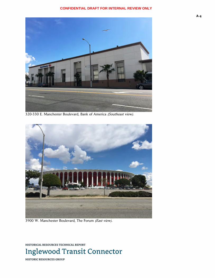
CONFIDENTIAL DRAFT FOR INTERNAL REVIEW ONLY
HISTORICAL RESOURCES TECHNICAL REPORT
Inglewood Transit Connector HISTORIC RESOURCES GROUP
A-4
320-330 E. Manchester Boulevard, Bank of America (Southeast view).
3900 W. Manchester Boulevard, The Forum (East view).

CONFIDENTIAL DRAFT FOR INTERNAL REVIEW ONLY
HISTORICAL RESOURCES TECHNICAL REPORT
Inglewood Transit Connector HISTORIC RESOURCES GROUP
A-5
3900 W. Manchester Boulevard, The Forum (East view, detail).
3900 W. Manchester Boulevard, The Forum and Los Angeles Stadium (Southeast view).
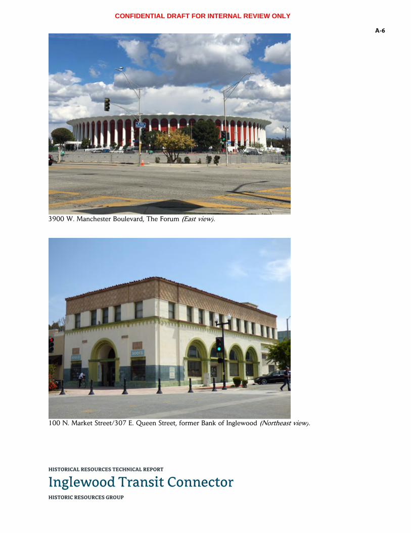
CONFIDENTIAL DRAFT FOR INTERNAL REVIEW ONLY
HISTORICAL RESOURCES TECHNICAL REPORT
Inglewood Transit Connector HISTORIC RESOURCES GROUP
A-6
3900 W. Manchester Boulevard, The Forum (East view).
100 N. Market Street/307 E. Queen Street, former Bank of Inglewood (Northeast view).

CONFIDENTIAL DRAFT FOR INTERNAL REVIEW ONLY
HISTORICAL RESOURCES TECHNICAL REPORT
Inglewood Transit Connector HISTORIC RESOURCES GROUP
A-7
100 N. Market Street/307 E. Queen Street, former Bank of Inglewood (East view, detail).
115 N. Market Street, former Fox Theater (Northwest view).

CONFIDENTIAL DRAFT FOR INTERNAL REVIEW ONLY
HISTORICAL RESOURCES TECHNICAL REPORT
Inglewood Transit Connector HISTORIC RESOURCES GROUP
A-8
115 N. Market Street, former Fox Theater (West view).
115 N. Market Street, former Fox Theater (Southwest view, detail).

CONFIDENTIAL DRAFT FOR INTERNAL REVIEW ONLY
HISTORICAL RESOURCES TECHNICAL REPORT
Inglewood Transit Connector HISTORIC RESOURCES GROUP
A-9
115 N. Market Street, former Fox Theater (Southwest view).
158-170 N. Market Street, former United Bank of California (East view).

CONFIDENTIAL DRAFT FOR INTERNAL REVIEW ONLY
HISTORICAL RESOURCES TECHNICAL REPORT
Inglewood Transit Connector HISTORIC RESOURCES GROUP
A-10
158-170 N. Market Street, former United Bank of California (Southeast view).
129-139 S. Market Street, former J.C. Penney (Southwest view).

CONFIDENTIAL DRAFT FOR INTERNAL REVIEW ONLY
HISTORICAL RESOURCES TECHNICAL REPORT
Inglewood Transit Connector HISTORIC RESOURCES GROUP
A-11
129-139 S. Market Street, former J.C. Penney (Northwest view).
149-155 S. Market Street/231-239 E. Manchester Boulevard, Professional Building (Northwest view).

CONFIDENTIAL DRAFT FOR INTERNAL REVIEW ONLY
HISTORICAL RESOURCES TECHNICAL REPORT
Inglewood Transit Connector HISTORIC RESOURCES GROUP
A-12
149-155 S. Market Street/231-239 E. Manchester Boulevard, Professional Building (Northeast view).
149-155 S. Market Street/231-239 E. Manchester Boulevard, Professional Building (Southwest view, detail).

CONFIDENTIAL DRAFT FOR INTERNAL REVIEW ONLY
HISTORICAL RESOURCES TECHNICAL REPORT
Inglewood Transit Connector HISTORIC RESOURCES GROUP
A-13
150 S. Market Street, former People’s Federal Building & Loan Association (Northeast view).
150 S. Market Street, former People’s Federal Building & Loan Association (North view).

CONFIDENTIAL DRAFT FOR INTERNAL REVIEW ONLY
HISTORICAL RESOURCES TECHNICAL REPORT
Inglewood Transit Connector HISTORIC RESOURCES GROUP
A-14
150 S. Market Street, former People’s Federal Building & Loan Association (Northeast view, detail).
619-635 S. Prairie Avenue, Lighthouse McCormick Mortuary (Northwest view).

CONFIDENTIAL DRAFT FOR INTERNAL REVIEW ONLY
HISTORICAL RESOURCES TECHNICAL REPORT
Inglewood Transit Connector HISTORIC RESOURCES GROUP
A-15
619-635 S. Prairie Avenue, Lighthouse McCormick Mortuary (West view).
619-635 S. Prairie Avenue, Lighthouse McCormick Mortuary (Northwest view).

CONFIDENTIAL DRAFT FOR INTERNAL REVIEW ONLY
HISTORICAL RESOURCES TECHNICAL REPORT
Inglewood Transit Connector HISTORIC RESOURCES GROUP
A-16
720 E. Florence Avenue, Inglewood Park Cemetery, main entrance (Southwest view).
720 E. Florence Avenue, Inglewood Park Cemetery, Grace Chapel (Southeast view).

CONFIDENTIAL DRAFT FOR INTERNAL REVIEW ONLY
HISTORICAL RESOURCES TECHNICAL REPORT
Inglewood Transit Connector HISTORIC RESOURCES GROUP
A-17
720 E. Florence Avenue, Inglewood Park Cemetery, Inglewood Mausoleum (Northeast view).
720 E. Florence Avenue, Inglewood Park Cemetery, Mausoleum of the Golden West (North view).

CONFIDENTIAL DRAFT FOR INTERNAL REVIEW ONLY
HISTORICAL RESOURCES TECHNICAL REPORT
Inglewood Transit Connector HISTORIC RESOURCES GROUP
A-18
720 E. Florence Avenue, Inglewood Park Cemetery (West view).
Market Street, looking south toward Queen Street.

CONFIDENTIAL DRAFT FOR INTERNAL REVIEW ONLY
HISTORICAL RESOURCES TECHNICAL REPORT
Inglewood Transit Connector HISTORIC RESOURCES GROUP
A-19
Market Street, looking north from Queen Street.
Market Street, looking north from Manchester Boulevard.

CONFIDENTIAL DRAFT FOR INTERNAL REVIEW ONLY
HISTORICAL RESOURCES TECHNICAL REPORT
Inglewood Transit Connector HISTORIC RESOURCES GROUP
A-20
Manchester Boulevard, looking east toward Market Street.
Manchester Boulevard, looking west toward Market Street.

CONFIDENTIAL DRAFT FOR INTERNAL REVIEW ONLY
HISTORICAL RESOURCES TECHNICAL REPORT
Inglewood Transit Connector HISTORIC RESOURCES GROUP
A-21
Manchester Boulevard, looking west from Locust Street.
Prairie Avenue, looking north from Kelso Street.

CONFIDENTIAL DRAFT FOR INTERNAL REVIEW ONLY
HISTORICAL RESOURCES TECHNICAL REPORT
Inglewood Transit Connector HISTORIC RESOURCES GROUP
A-22
The Forum and Los Angeles Stadium from Inglewood Park Cemetery (Southwest view).

CONFIDENTIAL DRAFT FOR INTERNAL REVIEW ONLY
HISTORICAL RESOURCES TECHNICAL REPORT
Inglewood Transit Connector HISTORIC RESOURCES GROUP
B-1 APPENDIX B: LIST OF PARCELS IN THE PROJECT AREA AND EXPANDED STUDY AREA
The following is a complete listing of all parcels examined as part of the Project Area and Expanded Study Area for the Inglewood Transit Connector project’s Locally Preferred Alternative and Market Street Station Alternative. This includes all parcels fronting the alignment right-of-way on both sides, and all parcels where new construction is proposed—including the Maintenance & Storage Facility (MSF) site; the Intermodal Transportation Facility site; the four possible Traction Power Substation sites; the alternate site for the Market Street Station; the sites where vertical circulation elements for the five APM stations will land; and the sites where pedestrian bridges will land. Where there will be substantial new construction outside of the alignment right-of-way, parcels immediately adjacent to or across from the new construction are also included.
ADDRESS APN DATE NAME/
DESCRIPTION
ALONG ALIGN-MENT
MSF ITF TPSS PED
BRIDGE
MARKET STREET
STATION ALTER-NATIVE
617 E Buckthorn St
4021044009 1925 Single‐family residence
X
4000 W Century Bl 4034004026 1963 Three 1‐story commercial buildings, parking lot
X
4001 W Century Bl 4024044014 c. 2000 Portion of a site containing a Chevron gas station and McDonald's
X
300 E Florence Ave
4015027031 1967 Fiesta Martin Bar & Grill, shopping center parking lot
X Market St Station Alt site
310 E Florence Ave
4015027030 1973 Market St Station Alt site
317 E Florence Ave
4015019902 0 Vacant lot Florence Ave ped bridge
319 E Florence Ave
4015019904 0 Vacant lot Florence Ave ped bridge
325 E Florence Ave
4015019905 0 Vacant lot Florence Ave ped bridge
327 E Florence Ave
4015019906 0 Vacant lot Florence Ave ped bridge
330 E Florence Ave
4015027029 1978 Market St Station Alt site
333 E Florence Ave
4015019907 0 Vacant lot Florence Ave ped bridge

CONFIDENTIAL DRAFT FOR INTERNAL REVIEW ONLY
HISTORICAL RESOURCES TECHNICAL REPORT
Inglewood Transit Connector HISTORIC RESOURCES GROUP
B-2
ADDRESS APN DATE NAME/
DESCRIPTION
ALONG ALIGN-MENT
MSF ITF TPSS PED
BRIDGE
MARKET STREET
STATION ALTER-NATIVE
335 E Florence Ave
4015019908 0 Vacant lot Florence Ave ped bridge
409 Grace Ave 4015021044 1986 Strip mall, parking lot
Market St Station Alt
adjacent
336 E Hillcrest Bl 4021023001 1962 5‐story office building
MSF adjacent
401 E Hillcrest Bl 4021012014 1953 New Wave Property, 1‐story commercial office building, parking lot
MSF adjacent
401 E Hillcrest Bl/256 S Locust St
4021012007 1946 Emerald Chateau, J.J.’s Bistro, 1‐story commercial office building
MSF adjacent
421‐427 E Hillcrest Bl
4021012011 1949 Kali Squeeze, 1‐story commercial storefront building
MSF adjacent
431 E Hillcrest Bl 4021012010 1959 McCormick Ambulance, 1‐story commercial office, parking lot
MSF adjacent
110 S La Brea Ave 4021009037 1987 5‐story office building (on La Brea), rear parking lot (on Market)
X
130 N Locust Ave 4021006027 1970 Forum Dental Group, 1‐story office building
Market St Station Alt
adjacent
151 N Locust Ave 4021007026 1977 Regent Towers, 7‐story apartment complex
Market St Station Alt
adjacent
200‐202 N Locust Ave/405‐413 E Regent St
4015026038 1950 Market St Station Alt
adjacent
204 N Locust Ave 4015026037 1933 Single‐family residence
Market St Station Alt
adjacent
208 N Locust Ave 4015026029 1941 Single‐family residence
Market St Station Alt
adjacent

CONFIDENTIAL DRAFT FOR INTERNAL REVIEW ONLY
HISTORICAL RESOURCES TECHNICAL REPORT
Inglewood Transit Connector HISTORIC RESOURCES GROUP
B-3
ADDRESS APN DATE NAME/
DESCRIPTION
ALONG ALIGN-MENT
MSF ITF TPSS PED
BRIDGE
MARKET STREET
STATION ALTER-NATIVE
212 N Locust Ave 4015026028 1931 Single‐family residence
Market St Station Alt
adjacent
218 N Locust Ave 4015026027 1947 Single‐family residence
Market St Station Alt
adjacent
220 N Locust Ave 4015026026 1941 Single‐family residence
Market St Station Alt
adjacent
222‐224 N Locust Ave
4015026025 1949 Multi‐family residence
Market St Station Alt
adjacent
228 N Locust Ave 4015026024 1942 Single‐family residence
Market St Station Alt
adjacent
232 N Locust Ave 4015026023 1949 Market St Station Alt
adjacent
236 N Locust Ave 4015026022 1945 Market St Station Alt
adjacent
240 N Locust Ave 4015026021 1925 Market St Station Alt
adjacent
244 N Locust Ave 4015026040, 4015026041, 4015026042, 4015026043, 4015026044, 4015026046, 4015026047, 4015026048, 4015026049
1960 Market St Station Alt
adjacent
248 N Locust Ave 4015026019 1951 1‐story office building
Market St Station Alt
adjacent
260 N Locust Ave 4015026039 1914 Holy Faith Episcopal Church (church, rectory and school)
Market St Station Alt
adjacent

CONFIDENTIAL DRAFT FOR INTERNAL REVIEW ONLY
HISTORICAL RESOURCES TECHNICAL REPORT
Inglewood Transit Connector HISTORIC RESOURCES GROUP
B-4
ADDRESS APN DATE NAME/
DESCRIPTION
ALONG ALIGN-MENT
MSF ITF TPSS PED
BRIDGE
MARKET STREET
STATION ALTER-NATIVE
302 E Manchester Bl/200‐204 S Market St
4021013019 1941 Cox Menswear, 2‐story commercial building
X
320‐330 E Manchester Bl
4021013018 1948 Bank of America X
335‐337 E Manchester Bl
4021010023 1947 2‐story professional office building
X
343‐345 E Manchester Bl
4021010022 1942 2‐story professional office building
X
355 E Manchester Bl
4021010021 1966 2‐story professional office building
X
400‐412 E Manchester Bl
4021012002 1962 1‐story commercial storefronts
X
401 E Manchester Bl
4021006030 1999 McDonald’s, Flip It, 3 1‐story commercial buildings, parking lot
X
420‐424 E Manchester Bl
4021012001 1949 1‐story commercial storefronts
X
428‐440 E Manchester Bl
4021012008 1953 1‐story commercial storefronts
X
450 E Manchester Bl
4021012015 1969 Bruno’s, walk‐up food stand
X
500 E Manchester Bl
4021024015 1994 Vons supermarket, Vons gas station, parking lot
X MSF site
Possible TPSS site
511‐515 E Manchester Bl
4021025001 1938 H&R Block, Hillcrest Medical Clinic, 2‐story mixed‐use storefront/office building; 1‐story commercial building
X
521‐525 E Manchester Bl
4021025026 1951 1‐story storefront building
X
529 E Manchester Bl
4021025017 1951 Mattress 4 Less, 1‐story storefront building
X
600‐604 E Manchester Bl
4021028237 2001 Auto service garage (multiple bays)
X
601‐609 E Manchester Bl
4021027035 1962 1‐story professional building
X
614‐620 E Manchester Bl
4021028024 1964 RTJ Professional Building, 2‐story professional building
X

CONFIDENTIAL DRAFT FOR INTERNAL REVIEW ONLY
HISTORICAL RESOURCES TECHNICAL REPORT
Inglewood Transit Connector HISTORIC RESOURCES GROUP
B-5
ADDRESS APN DATE NAME/
DESCRIPTION
ALONG ALIGN-MENT
MSF ITF TPSS PED
BRIDGE
MARKET STREET
STATION ALTER-NATIVE
652‐656 E Manchester Bl
4021028025 1952 2‐story storefront/office building
X
656‐660 E Manchester Bl
4021028026 1956 1‐story storefront building, parking lot
X
700 E Manchester Bl
4021036041 1960 Regal Cleaners, Martino's Liquor, 1‐story commercial retail stores, parking lot
X
708 E Manchester Bl
4021036039 1965 2‐story commercial office building
X
709 E Manchester Bl
4021027014 1906 1‐story single‐family residence
X
712 E Manchester Bl
4021036040 1950 A Bright Beginning, Inc., preschool
X
713 E Manchester Bl
4021027013 1926 1‐story single‐family residence
X
714‐718 E Manchester Bl
4021036004 1968 Urban scholar academy, 1‐story commercial building
X
718‐732 E Manchester Bl
4021036005 1957 2‐story commercial office building
X
801 E Manchester Bl
4021027038 1988 M&M Soul Food, parking lot
X
802 E Manchester Bl
4021036062 1970 Clean King laundromat
X
808 E Manchester Bl
4021036025 1953 1‐story commercial office building
X
811 E Manchester Bl
4021027028 1977 Midas auto service building
X
814 E Manchester Bl
4021036026 0 Parking lot X
815 E Manchester Bl
4021027027 0 Parking lot X
816 E Manchester Bl
4021036027 0 Parking lot X
831 E Manchester Bl
4021027036 1971 Sizzler, parking lot X
3900 W Manchester Bl
4025001002 1967 The Forum X Possible TPSS site
501 Manchester Ter
4021005013 1962 Airport Gas X
622 Manchester Dr
4021027003 1928 1‐story single‐family residence
X

CONFIDENTIAL DRAFT FOR INTERNAL REVIEW ONLY
HISTORICAL RESOURCES TECHNICAL REPORT
Inglewood Transit Connector HISTORIC RESOURCES GROUP
B-6
ADDRESS APN DATE NAME/
DESCRIPTION
ALONG ALIGN-MENT
MSF ITF TPSS PED
BRIDGE
MARKET STREET
STATION ALTER-NATIVE
100 N Market St/307 E Queen St
4021007024 1927 Vajra Books & Gifts, 2‐story mixed‐use commercial (former Bank of Inglewood)
X
101‐107 N Market St/ 229‐243 Queen St
4021008912 1929 2‐story mixed‐use commercial
X
110‐114 N Market St
4021007020 1938 Storefronts X
115 N Market St 4021008006 1949 Former Fox Theater X
118‐122 N Market St
4021007019 1930 I Sports Two, storefronts
X
121‐125 N Market St
4021008913 1924 2‐story commercial building
X
122 N Market St 4021007018 1924 Creative House, 1‐story commercial storefront building
X
124‐126 N Market St
4021007017 1920 2‐story commercial storefront building
X
128 N Market St 4021007016 1924 Heart & Soul Grill, 2‐story mixed‐use commercial
X
129 N Market St 4021008004 1927 Middlebar on Market
X
132‐134 N Market St
4021007015 1926 Los Angeles Bridge Unit, 1‐story storefront building
X
133‐137 N Market St
4021008003 1910 1‐story commercial building, three storefronts
X
136‐144 N Market St
4021007904 0 Vacant lot X
139 N Market St 4021008914 0 Vacant lot X
150‐152 N Market St
4021007906 0 Vacant lot X
157‐167 N Market St
4021008001 1907 1‐story commercial storefront building
X
158‐170 N Market St
4021007012 1967 Broadway Federal Bank (former Union Bank of California)
X
200 N Market St 4015027051 1976 Drive‐thru bank tellers
X Market St Station Alt site
205 N Market St 4015028900 0 Parking lot X
210 N Market St 4015027050 1976 Market St Station Alt site
213 N Market St 4015028907 0 Vacant lot X
219 N Market St 4015028906 0 Vacant lot X
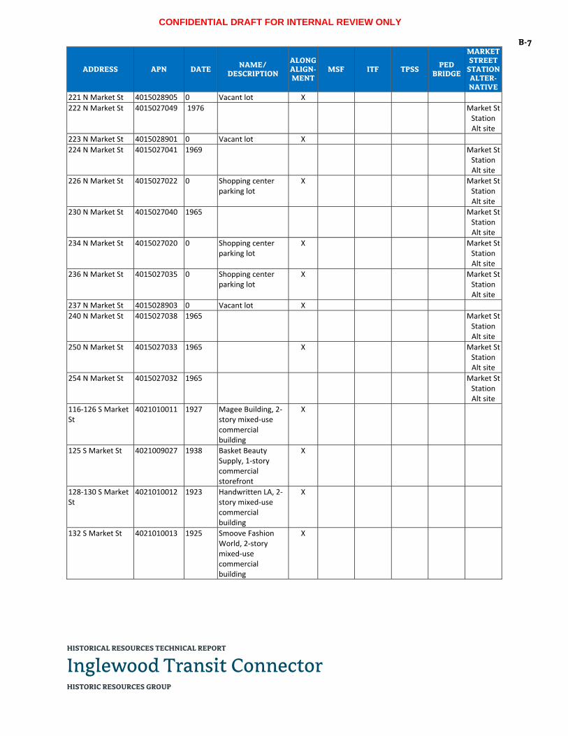
CONFIDENTIAL DRAFT FOR INTERNAL REVIEW ONLY
HISTORICAL RESOURCES TECHNICAL REPORT
Inglewood Transit Connector HISTORIC RESOURCES GROUP
B-7
ADDRESS APN DATE NAME/
DESCRIPTION
ALONG ALIGN-MENT
MSF ITF TPSS PED
BRIDGE
MARKET STREET
STATION ALTER-NATIVE
221 N Market St 4015028905 0 Vacant lot X
222 N Market St 4015027049 1976 Market St Station Alt site
223 N Market St 4015028901 0 Vacant lot X
224 N Market St 4015027041 1969 Market St Station Alt site
226 N Market St 4015027022 0 Shopping center parking lot
X Market St Station Alt site
230 N Market St 4015027040 1965 Market St Station Alt site
234 N Market St 4015027020 0 Shopping center parking lot
X Market St Station Alt site
236 N Market St 4015027035 0 Shopping center parking lot
X Market St Station Alt site
237 N Market St 4015028903 0 Vacant lot X
240 N Market St 4015027038 1965 Market St Station Alt site
250 N Market St 4015027033 1965 X Market St Station Alt site
254 N Market St 4015027032 1965 Market St Station Alt site
116‐126 S Market St
4021010011 1927 Magee Building, 2‐story mixed‐use commercial building
X
125 S Market St 4021009027 1938 Basket Beauty Supply, 1‐story commercial storefront
X
128‐130 S Market St
4021010012 1923 Handwritten LA, 2‐story mixed‐use commercial building
X
132 S Market St 4021010013 1925 Smoove Fashion World, 2‐story mixed‐use commercial building
X
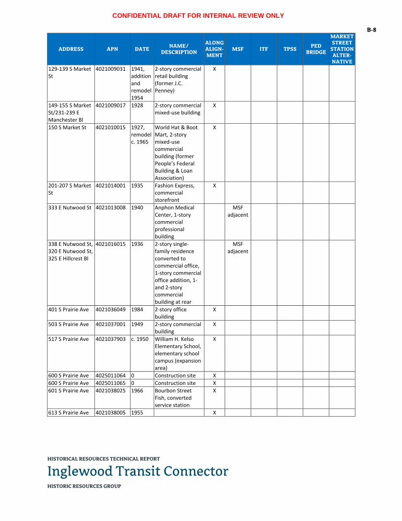
CONFIDENTIAL DRAFT FOR INTERNAL REVIEW ONLY
HISTORICAL RESOURCES TECHNICAL REPORT
Inglewood Transit Connector HISTORIC RESOURCES GROUP
B-8
ADDRESS APN DATE NAME/
DESCRIPTION
ALONG ALIGN-MENT
MSF ITF TPSS PED
BRIDGE
MARKET STREET
STATION ALTER-NATIVE
129‐139 S Market St
4021009031 1941, addition and remodel 1954
2‐story commercial retail building (former J.C. Penney)
X
149‐155 S Market St/231‐239 E Manchester Bl
4021009017 1928 2‐story commercial mixed‐use building
X
150 S Market St 4021010015 1927, remodel c. 1965
World Hat & Boot Mart, 2‐story mixed‐use commercial building (former People’s Federal Building & Loan Association)
X
201‐207 S Market St
4021014001 1935 Fashion Express, commercial storefront
X
333 E Nutwood St 4021013008 1940 Anphon Medical Center, 1‐story commercial professional building
MSF adjacent
338 E Nutwood St, 320 E Nutwood St, 325 E Hillcrest Bl
4021016015 1936 2‐story single‐family residence converted to commercial office, 1‐story commercial office addition, 1‐ and 2‐story commercial building at rear
MSF adjacent
401 S Prairie Ave 4021036049 1984 2‐story office building
X
503 S Prairie Ave 4021037001 1949 2‐story commercial building
X
517 S Prairie Ave 4021037903 c. 1950 William H. Kelso Elementary School, elementary school campus (expansion area)
X
600 S Prairie Ave 4025011064 0 Construction site X
600 S Prairie Ave 4025011065 0 Construction site X
601 S Prairie Ave 4021038025 1966 Bourbon Street Fish, converted service station
X
613 S Prairie Ave 4021038005 1955 X

CONFIDENTIAL DRAFT FOR INTERNAL REVIEW ONLY
HISTORICAL RESOURCES TECHNICAL REPORT
Inglewood Transit Connector HISTORIC RESOURCES GROUP
B-9
ADDRESS APN DATE NAME/
DESCRIPTION
ALONG ALIGN-MENT
MSF ITF TPSS PED
BRIDGE
MARKET STREET
STATION ALTER-NATIVE
619‐635 S Prairie Ave
4021038027 1948, addition c. 1960
Lighthouse McCormick Mortuary (former Hardin & Flanagan Colonial Chapel and Mortuary)
X
701 S Prairie Ave 4021044001 0 Vacant lot X
703 S Prairie Ave 4021044004 c. 1925 2 1½‐story single‐family residences
X
711 S Prairie Ave 4021044005 1947 Single‐family residence
X
713 S Prairie Ave 4021044006 1982 Single‐family residence
X
715 S Prairie Ave 4021044007 1959 Single‐family residence
X
723 S Prairie Ave 4021044008 1922 Single‐family residence
X
801 S Prairie Ave 4024007001 1967 Forum Liquor X
803 S Prairie Ave 4024007004 0 Parking lot X
805 S Prairie Ave 4024007005 1947 1‐ and 2‐story apartment building
X
813 S Prairie Ave 4024007006 1945 JP Termite, 1‐story commercial storefront
X
819 S Prairie Ave 4024007007 1953 Iglesia Cristiana Hispana, 1‐story commercial/industrial building
X
823‐825 S Prairie Ave
4024007008 1948 Hollywood Park Motel
X
901 S Prairie Ave 4024008024 1985 Strip mall X
919 S Prairie Ave 4024008020 1959 Inglewood Gardens, 2‐story apartment building
X
923 S Prairie Ave 4024008015 1949 Inglewood Electric Supply, 2‐story commercial building, 1‐story commercial building, rear garage, parking lot
X
937 S Prairie Ave 4024009004 0 Vacant lot X
945 S Prairie Ave 4024009005 1969 Pride Plaza, 2‐story commercial retail/office building
X
1003 S Prairie Ave 4024009007 1957 1‐story commercial office
X
1007 S Prairie Ave 4024009008 0 Vacant lot X

CONFIDENTIAL DRAFT FOR INTERNAL REVIEW ONLY
HISTORICAL RESOURCES TECHNICAL REPORT
Inglewood Transit Connector HISTORIC RESOURCES GROUP
B-10
ADDRESS APN DATE NAME/
DESCRIPTION
ALONG ALIGN-MENT
MSF ITF TPSS PED
BRIDGE
MARKET STREET
STATION ALTER-NATIVE
1011 S Prairie Ave 4024009015 1954 1‐story commercial office
X
1035 S Prairie Ave 4024009033 1971 Strip mall, Casa Rios restaurant, parking lot
X
1101 S Prairie Ave 4024042015 1970 Chu’s Chinese Restaurant, parking lot
X
1115 S Prairie Ave 4024042016 1924 Single‐family residence, other small structures
X
1125 S Prairie Ave 4024042017 1956 2‐story apartment building
X
1135 S Prairie Ave 4024043027 1961 2‐story apartment building complex
X
1201 S Prairie Ave 4024043030 1988 Auto Mall, auto service building
X
1225‐1229 S Prairie Ave
4024044013 1927 LAX Graphics, 1‐story commercial building (1225); 1‐story single‐family residence (1227); 2‐story apartment building (1229)
X
10004 S Prairie Ave
4032001039 1977 Church’s Chicken, 1‐story commercial building, parking lot
X
300 E Queen St, 306‐308 E Queen St, 100‐112 S Market St
4021010010 1990 2‐story mixed‐use commercial building
X
312 E Regent St 4021007011 0 Vacant lot Market St Station Alt
adjacent
331 E Spruce Ave 4021023011 1915 Tender Care, Inc., two single‐family residences converted to a school
MSF adjacent
336 E Spruce Ave 4021029009 1922 Wilder's Preparatory Academy, 1‐story single‐family residence converted to a school
MSF adjacent

CONFIDENTIAL DRAFT FOR INTERNAL REVIEW ONLY
HISTORICAL RESOURCES TECHNICAL REPORT
Inglewood Transit Connector HISTORIC RESOURCES GROUP
B-11
ADDRESS APN DATE NAME/
DESCRIPTION
ALONG ALIGN-MENT
MSF ITF TPSS PED
BRIDGE
MARKET STREET
STATION ALTER-NATIVE
430‐434 E Spruce Ave
4021028125‐4021028172
1989 Part of a condominium complex
MSF adjacent
436‐438 E Spruce Ave, 433‐435 E Tamarack Ave
4021028173‐4021028236
1989 Part of a condominium complex
MSF adjacent
(none) 4012031930 1905 Inglewood Park Cemetery
X
(none) 4015018900 0 Metro right‐of‐way Florence Ave ped bridge
(none) 4015027042 0 Shopping center parking lot
X Market St Station Alt site
(none) 4015027052 0 Shopping center parking lot
X Market St Station Alt site
(none) 4021010901 0 Parking lot X
(none) 4021025025 0 Parking lot X
(none) 4021027012 0 Vacant lot X
(none) 4021027015 0 Vacant lot X
(none) 4024007043 2003 Laundromat X
(none) 4025011043 0 Construction site X
(none) 4025011044 0 Construction site X
(none) 4025011046 0 Construction site X Possible TPSS site
(none) 4025011050 0 Construction site X ITF site
(none) 4025011901 0 Construction site X ITF site Possible TPSS site
(none) 4025011902 0 Construction site ITF site