Cotton Belt Corridor Regional Rail - DART.org - Dallas … Belt Corridor Regional Rail Project...
25
Prepared for Dallas Area Rapid Transit General Planning Consultant Managed by URS Corporation Cotton Belt Corridor Regional Rail Visual Impact Assessment Technical Memorandum December 2013
Transcript of Cotton Belt Corridor Regional Rail - DART.org - Dallas … Belt Corridor Regional Rail Project...

Prepared for Dallas Area Rapid Transit
General Planning Consultant Managed by URS Corporation
Cotton Belt Corridor Regional Rail Visual Impact Assessment
Technical Memorandum December 2013
Prepared for Dallas Area Rapid Transit
General Planning Consultant Managed by URS Corporation
Cotton Belt Corridor Regional Rail Visual Impact Assessment
Technical Memorandum December 2013
Prepared by URS Corporation

Cotton Belt Corridor Regional Rail Project
Visual Impact Assessment
Document Revision Record Project/Report Name: Visual Impact Assessment Technical Memorandum
URS Project Number: 25338842
PM: Dan Meyers PIC: Jerry Smiley
Revision Number Date
Draft Version 1 May 22, 2013
Final
Originator: Sign: Date:
Stephen Malloy, CLARB, LEED AP April 18, 2013
URS
Comments by: Nancy Stavish, URS April 22, 2013
Andrea Weckmueller-Behringer, ATG May 7, 2013
Megan Inman, URS May 16, 2013
Mark Ryan, URS May 22, 2013
Amber Majefski, URS September 8, 2013
Nancy Stavish, URS September 9, 2013
Reggie Herman, AICP, URS December 26, 2013
Task Manager Approval: Date:
Verified/Approved by: Date:
Distribution Name Title Firm

Cotton Belt Corridor Regional Rail Project
Visual Impact Assessment
TABLE OF CONTENTS 1.0 INTRODUCTION ........................................................................................................................... 1
2.0 IMPACT METHODOLOGY ............................................................................................................ 2
3.0 IMPACT ASSESSMENT .................................................................................................................. 8
3.1 Section 1-1: DFW Airport to Coppell Road ............................................................................... 8
3.2 Section 1-2A: Coppell Road to Moore Road ............................................................................. 8
3.3 Section 1-2B (Cypress Waters Alternative): Coppell Road to Moore Road .............................. 8
3.4 Section 1-3: Moore Road to the Coppell/Carrollton City Limits ............................................... 9
3.5 Section 2-1: Coppell/Carrollton City Limits to Hutton Drive .................................................... 9
3.6 Section 2-2: Hutton Drive to Erie Street ................................................................................. 10
3.7 Section 2-3: Erie Street to Dallas North Tollway .................................................................... 10
3.8 Section 3-1: Dallas North Tollway to White Rock Creek......................................................... 12
3.9 Section 3-2A (At-grade Profile Option): White Rock Creek to Coit Road ............................... 13
3.10 Section 3-2B (Trench Profile Option): White Rock Creek to Coit Road .................................. 14
3.11 Section 3-2C (Tunnel Profile Option): White Rock Creek to Coit Road .................................. 14
3.12 Section 3-3: Coit Road to Alma Road...................................................................................... 14
3.13 Section 3-4A (Red Line Interface North Alternative): Alma Road to N Avenue ..................... 15
3.14 Section 3-4B (Red Line Interface South Alternative): Alma Road to N Avenue ..................... 15
3.15 Section 3-5: N Avenue to Shiloh Road .................................................................................... 17
4.0 POTENTIAL MITIGATION OPTIONS ............................................................................................ 18
LIST OF TABLES
Table 2-1 Visual Impact Analysis Matrix ............................................................................................. 4
LIST OF FIGURES
Figure 2-1 Corridor Section Limits........................................................................................................ 3
Figure 3-1 Cypress Alternative adjacent to Oncor Electric parcel ....................................................... 9
Figure 3-2 Mockingbird Lane/Belt Line Road ....................................................................................... 9
Figure 3-3 Green Line LRT Aerial Station Platform ............................................................................ 10
Figure 3-4 Arapaho Bridge over Midway Road in Addison ................................................................ 11
Figure 3-5 Addison Circle Park ........................................................................................................... 12
Figure 3-6 Addison Circle Residential Complex ................................................................................. 12
Figure 3-7 Knoll Trail Drive ................................................................................................................. 12
Figure 3-8 Preston Road ..................................................................................................................... 13
Figure 3-9 Proposed Preston Road Station Location ......................................................................... 13
Figure 3-10 Mandalay Multi-family Residences at Coit Road .............................................................. 14
Figure 3-11 Coit Road ........................................................................................................................... 15
Figure 3-12 Renner Road ..................................................................................................................... 15
Figure 3-13 Proposed 12th
Street Station Location .............................................................................. 16
Figure 3-14 Red Line LRT over Cotton Belt Alignment ......................................................................... 16
Figure 3-15 PGBT over Red Line LRT .................................................................................................... 16
Figure 3-16 Electrical Substation at Shiloh Road ................................................................................. 17

Cotton Belt Corridor Regional Rail Project
Visual Impact Assessment 1
1.0 INTRODUCTION The following is an analysis of the visual impacts of the proposed project elements associated with the
Cotton Belt Corridor Regional Rail Project (Cotton Belt Project). It identifies changes in the existing visual
resources previously addressed in the Visual and Aesthetic Resources Existing Conditions Technical
Memorandum, dated October 31, 2011, and the effect of such changes on the experience of primary
viewers. Visual impacts are summarized in Table 2-1 and are described in Section 3.0 of the
memorandum. Potential mitigation options focusing on potentially significant and significant impacts
are described in Section 4.0.
The proposed project extends from the Dallas/Fort Worth International Airport (DFW Airport) eastward
to the Plano/Richardson area of Texas along an approximate 26-mile section of freight rail track located
within the Cotton Belt Corridor. The corridor passes through or abuts the communities of Grapevine,
Coppell, Dallas, Carrollton, Addison, Richardson and Plano. Proposed project elements include station
areas with rail passenger platforms, bus and taxi transfer areas, passenger shelters, parking, associated
site amenities, hard-surface pedestrian paths and landscaping, as well as the trains. In addition,
modifications may be made to the existing track within the Cotton Belt Corridor: for example, track
sections may be added and elevated, and walls added. The proposed regional rail project would operate
in conjunction with continued freight rail service, except through the North Dallas area. On January 22,
2010, through DART’s efforts, the Surface Transportation Board approved the abandonment of freight,
with an effective date of January 27, 2010, along the Cotton Belt Corridor from Knoll Trail in Dallas to
Renner Junction in Richardson. This was done in anticipation of implementing passenger service in the
corridor.

Cotton Belt Corridor Regional Rail Project
Visual Impact Assessment 2
2.0 IMPACT ASSESSMENT METHODOLOGY The assessment methodology is based upon the Federal Highway Administration’s (FHWA) Visual Impact
Assessment for Highway Projects (Publication Number: FHWA-HI-88-054) and DART’s Environmental
Impact Assessment and Mitigation Guidelines for Transit Projects, dated May 2012. For Cotton Belt
Project the limits of the visual environment extend approximately one-quarter mile on either side of the
existing freight rail track, throughout the length of the Cotton Belt Corridor. Information was collected
using online aerial imagery and ground-level photographs taken during repeated visits to the corridor. A
review of the notable characteristics and elements of both the natural and built landscape, an inventory
of viewer groups and an evaluation of the corridor’s existing visual quality as it relates to the perceptual
receptivity of those viewer groups, were included in the Visual and Aesthetic Resources Existing
Conditions Technical Memorandum. This memorandum identifies and evaluates the degree to which the
proposed rail redevelopment will visually impact the perceived quality of the existing environment.
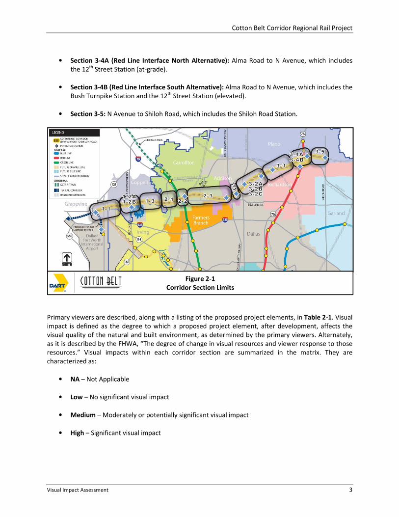
The corridor, along with the proposed station areas, has been divided into the following 15 sections,
shown on Figure 2-1:
• Section 1-1: DFW Airport to Coppell Road, which includes the DFW North Station.
• Section 1-2A: Coppell Road to Moore Road.
• Section 1-2B (Cypress Waters Alternative): Coppell Road to Moore Road, which includes the
North Lake Station.
• Section 1-3: Moore Road to the Coppell/Carrollton City Limits.
• Section 2-1: Coppell/Carrollton City Limits to Hutton Drive.
• Section 2-2: Hutton Drive to Erie Street, which includes the Downtown Carrollton Station.
• Section 2-3: Erie Street to Dallas North Tollway, which includes the Addison Transit Center
Station.
• Section 3-1: Dallas North Tollway to White Rock Creek, which includes the Knoll Trail Station.
• Section 3-2A (At-grade Profile Option): White Rock Creek to Coit Road, which includes the
Preston Road Station and the Renner Village Station (two location options)
• Section 3-2B (Trench Profile Option): White Rock Creek to Coit Road, which includes the
Preston Road Station and the Renner Village Station (two location options).
• Section 3-2C (Tunnel Profile Option): White Rock Creek to Coit Road, which includes the
Preston Road Station and the Renner Village Station (two location options).
• Section 3-3: Coit Road to Alma Road, which includes the University of Texas at Dallas (UTD)/
Synergy Station.
Cotton Belt Corridor Regional Rail Project
Visual Impact Assessment 3
• Section 3-4A (Red Line Interface North Alternative): Alma Road to N Avenue, which includes
the 12th
Street Station (at-grade).
• Section 3-4B (Red Line Interface South Alternative): Alma Road to N Avenue, which includes the
Bush Turnpike Station and the 12th
Street Station (elevated).
• Section 3-5: N Avenue to Shiloh Road, which includes the Shiloh Road Station.
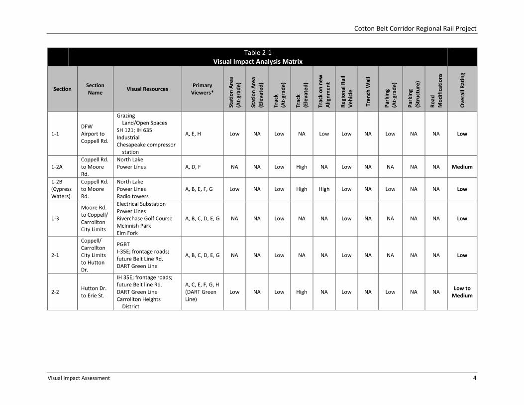
Primary viewers are described, along with a listing of the proposed project elements, in Table 2-1. Visual
impact is defined as the degree to which a proposed project element, after development, affects the
visual quality of the natural and built environment, as determined by the primary viewers. Alternately,
as it is described by the FHWA, “The degree of change in visual resources and viewer response to those
resources.” Visual impacts within each corridor section are summarized in the matrix. They are
characterized as:
• NA – Not Applicable
• Low – No significant visual impact
• Medium – Moderately or potentially significant visual impact
• High – Significant visual impact
Figure 2-1
Corridor Section Limits
Cotton Belt Corridor Regional Rail Project
Visual Impact Assessment 4
Table 2-1
Visual Impact Analysis Matrix
Section Section
Name Visual Resources
Primary
Viewers*
Sta
tio
n A
rea
(At-
gra
de
)
Sta
tio
n A
rea
(Ele
va
ted
)
Tra
ck
(At-
gra
de
)
Tra
ck
(Ele
va
ted
)
Tra
ck o
n n
ew
Ali
gn
me
nt
Re
gio
na
l R
ail
Ve
hic
le
Tre
nch
Wa
ll
Pa
rkin
g
(At-
gra
de
)
Pa
rkin
g
(Str
uct
ure
)
Ro
ad
Mo
dif
ica
tio
ns
Ov
era
ll R
ati
ng
1-1
DFW
Airport to
Coppell Rd.
Grazing
Land/Open Spaces
SH 121; IH 635
Industrial
Chesapeake compressor
station
A, E, H Low NA Low NA Low Low NA Low NA NA Low
1-2A
Coppell Rd.
to Moore
Rd.
North Lake
Power Lines
A, D, F NA NA Low High NA Low NA NA NA NA Medium
1-2B
(Cypress
Waters)
Coppell Rd.
to Moore
Rd.
North Lake
Power Lines
Radio towers
A, B, E, F, G Low NA Low High High Low NA Low NA NA Low
1-3
Moore Rd.
to Coppell/
Carrollton
City Limits
Electrical Substation
Power Lines
Riverchase Golf Course
McInnish Park
Elm Fork
A, B, C, D, E, G NA NA Low NA NA Low NA NA NA NA Low
2-1
Coppell/
Carrollton
City Limits
to Hutton
Dr.
PGBT
I-35E; frontage roads;
future Belt Line Rd.
DART Green Line
A, B, C, D, E, G NA NA Low NA NA Low NA NA NA NA Low
2-2 Hutton Dr.
to Erie St.
IH 35E; frontage roads;
future Belt line Rd.
DART Green Line
Carrollton Heights
District
A, C, E, F, G, H
(DART Green
Line)
Low NA Low High NA Low NA Low NA NA Low to
Medium
Cotton Belt Corridor Regional Rail Project
Visual Impact Assessment 5
Table 2-1
Visual Impact Analysis Matrix
Section Section
Name Visual Resources
Primary
Viewers*
Sta
tio
n A
rea
(At-
gra
de
)
Sta
tio
n A
rea
(Ele
va
ted
)
Tra
ck
(At-
gra
de
)
Tra
ck
(Ele
va
ted
)
Tra
ck o
n n
ew
Ali
gn
me
nt
Re
gio
na
l R
ail
Ve
hic
le
Tre
nch
Wa
ll
Pa
rkin
g
(At-
gra
de
)
Pa
rkin
g
(Str
uct
ure
)
Ro
ad
Mo
dif
ica
tio
ns
Ov
era
ll R
ati
ng
2-3
Erie St. to
Dallas
North
Tollway
Carrollton Heights
District
Honors Golf Club
Addison Airport
Addison Transit Center
Addison Circle
Addison Circle Park
Arapaho Bridge
Addison Pedestrian Trail
A, B, C, D, E,
F, G Low NA Low High NA Low NA Low NA NA Medium
3-1
Dallas
North
Tollway to
White Rock
Creek
Electrical Substation
Power Lines
White Rock Creek
Prestonwood Country
Club
A, C, E, G Low NA Low NA NA Low NA NA NA NA Low
3-2A
(At-
grade)
White Rock
Creek to
Coit Rd.
White Rock Creek
Prestonwood Country
Club
Keller Springs Park
Preston Road
Fairhill School
McKamy Branch
Woodlands
Power Lines
A, B, C, D, E,
F, G, H
(Institutional)
Low NA Low NA NA Low NA Low NA Med. Low to
Medium
3-2B
( Trench)
White Rock
Creek to
Coit Rd.
White Rock Creek
Prestonwood Country
Club
Keller Springs Park
Preston Road
Fairhill School
McKamy Branch
Woodlands
Power Lines
A, B, C, D, E,
F, G, H
(Institutional)
Low NA Low NA NA Low High Low NA High High

Cotton Belt Corridor Regional Rail Project
Visual Impact Assessment 6
Table 2-1
Visual Impact Analysis Matrix
Section Section
Name Visual Resources
Primary
Viewers*
Sta
tio
n A
rea
(At-
gra
de
)
Sta
tio
n A
rea
(Ele
va
ted
)
Tra
ck
(At-
gra
de
)
Tra
ck
(Ele
va
ted
)
Tra
ck o
n n
ew
Ali
gn
me
nt
Re
gio
na
l R
ail
Ve
hic
le
Tre
nch
Wa
ll
Pa
rkin
g
(At-
gra
de
)
Pa
rkin
g
(Str
uct
ure
)
Ro
ad
Mo
dif
ica
tio
ns
Ov
era
ll R
ati
ng
3-2C
(Tunnel)
White Rock
Creek to
Coit Rd.
White Rock Creek
Prestonwood Country
Club
Keller Springs Park
Preston Road
Fairhill School
McKamy Branch
Woodlands
Power Lines
A, B, C, D, E,
F, G, H
(Institutional)
Low NA Low NA NA Low NA Low NA Med. Low
3-3 Coit Rd. to
Alma Rd.
Agricultural Lands/
Open Spaces
Highland Springs
Bombardier Aerospace
West Renner Road
Crossing
Synergy Park Blvd.
Crossing
A, C, E, F, G, H
(Institutional) Low NA Low NA NA Low NA Low NA NA Low
3-4A
(North)
Alma Rd. to
N Ave.
Plano Parkway Crossing
Power Lines
President George Bush
Turnpike (PGBT) West
US 75
DART Red Line
A, B, C, E, F,
G, H (DART
Red Line)
Low NA Low Low-
Med. NA Low NA Low NA NA Low
3-4B
(South)
Alma Rd. to
N Ave.
Power Lines
President George Bush
Turnpike (PGBT) West
US 75
DART Red Line/Bush
Turnpike Station
Spring Creek
Agricultural Lands/
Open Space
A, B, C, E, F,
G, H (DART
Red Line)
Low Med. Low High High Low NA Low NA High High
Cotton Belt Corridor Regional Rail Project
Visual Impact Assessment 7
Table 2-1
Visual Impact Analysis Matrix
Section Section
Name Visual Resources
Primary
Viewers*
Sta
tio
n A
rea
(At-
gra
de
)
Sta
tio
n A
rea
(Ele
va
ted
)
Tra
ck
(At-
gra
de
)
Tra
ck
(Ele
va
ted
)
Tra
ck o
n n
ew
Ali
gn
me
nt
Re
gio
na
l R
ail
Ve
hic
le
Tre
nch
Wa
ll
Pa
rkin
g
(At-
gra
de
)
Pa
rkin
g
(Str
uct
ure
)
Ro
ad
Mo
dif
ica
tio
ns
Ov
era
ll R
ati
ng
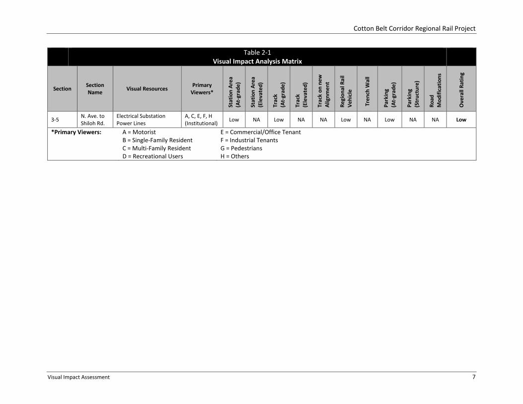
3-5 N. Ave. to
Shiloh Rd.
Electrical Substation
Power Lines
A, C, E, F, H
(Institutional) Low NA Low NA NA Low NA Low NA NA Low
*Primary Viewers:
A = Motorist
B = Single-Family Resident
C = Multi-Family Resident
D = Recreational Users
E = Commercial/Office Tenant
F = Industrial Tenants
G = Pedestrians
H = Others
Cotton Belt Corridor Regional Rail Project
Visual Impact Assessment 8
3.0 IMPACT ASSESSMENT
The visual impacts associated with each section are described below. NOTE: the Visual and Aesthetic
Resources Existing Conditions Technical Memorandum contains definitions for visual quality, visual
sensitivity as well as sensitive receptors/assets assessments.
This impact assessment does not address the visual impacts of noise walls that could be necessary in
specific areas along the corridor to mitigate significant adverse noise impacts. Generally, in areas where
noise walls are constructed, there could be both positive and negative visual impacts for the primary
viewers. Positive visual impacts of a noise wall could include providing a barrier to prevent rail
passengers from viewing private spaces (inside homes, into backyards) and providing a visual buffer to
diminish views of the tracks and rail vehicles by the primary viewers. An adverse visual impact of a noise
wall could be the obstruction of existing views for the primary viewers.
3.1 Section 1-1: DFW Airport to Coppell Road
The area is characterized as flat, agricultural grazing land with scattered low vegetation near DFW
Airport to industrial developments near Coppell Road and the Chesapeake Compressor Station between
State Highway (SH) 121 and Interstate Highway (IH) 635. There is little visual diversity, and there are no
visual resources that are particularly important to viewers: the dominant visual elements are SH 114, SH
121, and IH 635. Visual quality and visual sensitivity are low. Although viewed primarily from the
highways, with elevated vantage points and lengthy, middle-ground exposure, the proposed at-grade
station and track should have low visual impact, and should support expectations for future
development in the area.
3.2 Section 1-2A: Coppell Road to Moore Road
The built environment along the track is mostly light industrial, with single-family residences east and
west of South Denton Tap Road primarily to the north. The existing track crosses South Denton Tap
Road at grade. There is a highly visible, high-voltage power line paralleling the track to the south. East
and west of South Denton Tap Road to Moore Road, mature trees help to buffer the tracks from the
residences to the north and the industrial buildings to the south. Visual quality and visual sensitivity are
low. The proposed (by others) future Cotton Belt Trail will be located along the north of the track, which
would afford recreational users close-up views, but views of the at grade portion of the Cotton Belt
Project from elsewhere would be intermittent. The Cotton Belt Project facilities would include an
elevated guideway over South Denton Tap Road (while the existing freight track will remain at grade
through this intersection), which could be visible to some residents of the Chateaus of Coppell
neighborhood. This neighborhood abuts the existing Cotton Belt Corridor and Denton Tap Road, so the
southeastern edge of the neighborhood would be adjacent to the aerial rail structure over Denton Tap
Road. Due to the proximity of homes to the elevated rail crossing, the Base Alternative of the proposed
project would result in an overall medium visual impact.
3.3 Section 1-2B (Cypress Waters Alternative): Coppell Road to Moore Road
The proposed Cypress Waters Alternative rail alignment veers southward at Coppell Road to cross over
South Denton Tap Road before returning to grade west of the proposed North Lake Station. It returns to
the Cotton Belt Corridor at Moore Road (while the freight track will remain at grade and operational
between Coppell Road and Moore Road). The North Lake Station is located along the northwest shore of
Cotton Belt Corridor Regional Rail Project
Visual Impact Assessment 9
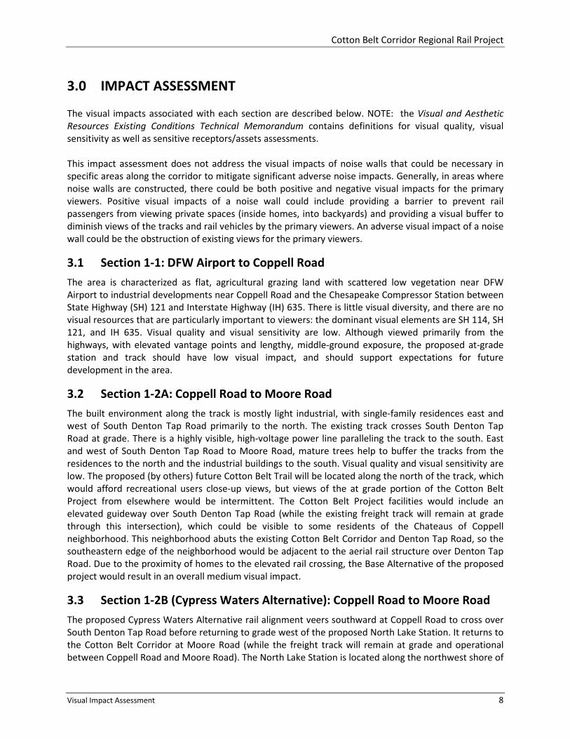
North Lake at the Belt Line Trade Center. The landscape is dominated by the lake, power poles, three
500-foot radio towers, an electrical substation near the south terminus of Moore Road, and a somewhat
scarred landscape after the October 2012 implosion of a Luminant Energy power plant (refer to Figures
3-1 and 3-2). As such, the visual quality and visual sensitivity are low, although there are plans for a
multi-use, residential and retail development along the lakeshore, which will significantly alter visual
quality and visual sensitivity. With construction of the station, vehicular and pedestrian traffic along East
Belt Line Road will increase, and viewer exposure and awareness will increase. Also, the visual impact of
the elevated track over South Denton Tap Road would be high. The station and track are intended to be
an integral part of the proposed redevelopment, and the power poles and electrical substation are likely
to remain as dominant elements in the landscape, therefore, the overall visual impact would be low.
Figure 3-1
Cypress Alternative adjacent to Oncor Electric
Parcel
Figure 3-2
Mockingbird Lane/Belt Line Road
Looking southeast East Belt Line Road, looking southwest
3.4 Section 1-3: Moore Road to the Coppell/Carrollton City Limits
Multi-family residences parallel the track to the north, east of Mockingbird Lane, while single family
residences parallel the track to the north, west of Mockingbird Lane. South of the track are large
wooded areas to South MacArthur Boulevard. Mixed-use buildings and multi-family residences line the
south side of the track, east of South MacArthur Boulevard. East Belt Line Road runs along the south
side of the track, and South MacArthur Boulevard crosses the track at grade. Visual quality and visual
sensitivity are low. View sheds from the road are lengthy and close; views from the neighboring
residential development are generally unimpeded. Furthermore the track is visible as a mid-ground
feature from portions of the Riverchase Golf Course. Rail operations associated with Cotton Belt Project
should not differ greatly from existing track use, and because there is no proposed station, little change
to the perception of the visual landscape, thus low visual impact.
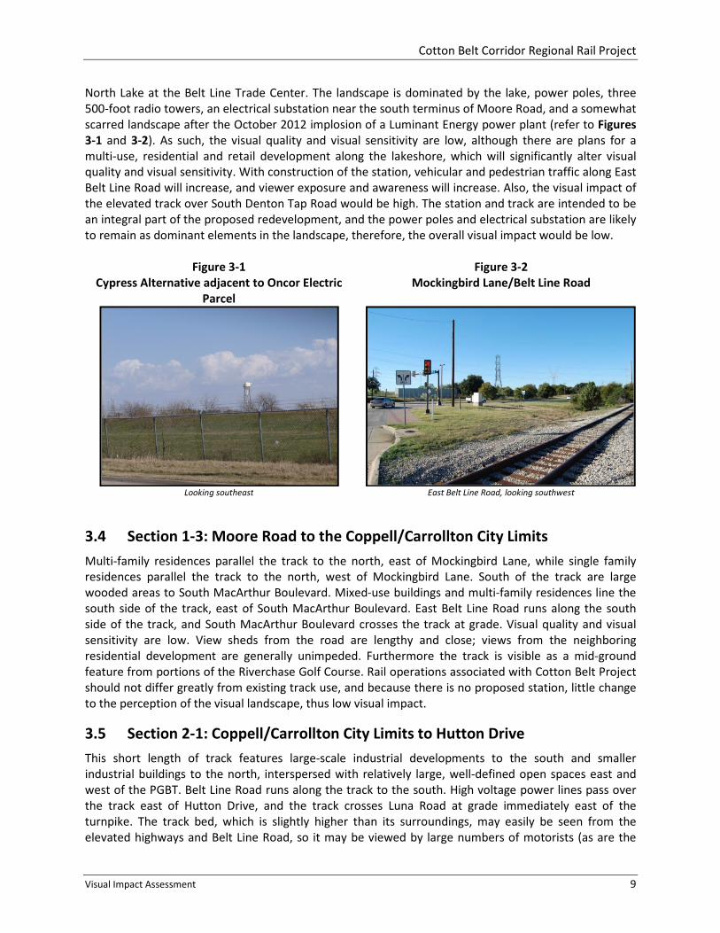
3.5 Section 2-1: Coppell/Carrollton City Limits to Hutton Drive
This short length of track features large-scale industrial developments to the south and smaller
industrial buildings to the north, interspersed with relatively large, well-defined open spaces east and
west of the PGBT. Belt Line Road runs along the track to the south. High voltage power lines pass over
the track east of Hutton Drive, and the track crosses Luna Road at grade immediately east of the
turnpike. The track bed, which is slightly higher than its surroundings, may easily be seen from the
elevated highways and Belt Line Road, so it may be viewed by large numbers of motorists (as are the

Cotton Belt Corridor Regional Rail Project
Visual Impact Assessment 10
power poles), if only for a short time. Visual quality and visual sensitivity are low. The landscape lacks
diversity, and there are no attractive, built or natural features. Rail operations associated with the
Cotton Belt Project should not differ greatly from existing track use, and there is no proposed station.
Therefore, visual impact would be low.
3.6 Section 2-2: Hutton Drive to Erie Street
The built environment is varied and dominant as it changes from large industrial uses to the smaller-
scale urban character of downtown Carrollton. The proposed Cotton Belt Rail station would be located
east of IH 35E and immediately north of the existing Downtown Carrollton DART Green Line LRT Station
with its elevated guideway and platforms (refer to Figure 3-3). The alignment passes under IH 35E and
the DART guideway, crossing the IH 35E frontage roads and North Broadway Street. TxDOT is planning to
rebuild the highway, frontage roads, and Belt Line Road, however, so the visual landscape of this area
would change considerably. The current plans call for elevating Belt Line Road and the frontage roads
over the ground-level tracks and raising the rebuilt IH 35E above these roadways and above the existing
height of the highway. Downtown Carrollton, with its mostly one and two-story buildings, lies to the
south. As the grade rises gradually eastward to Erie Street, the station, track and elevated track over the
freight tracks may easily be seen from a number of vantage points and a variety of viewers: the
elevated highway, DART guideway and station platform, along the future Cotton Belt Trail and Belt Line
Road, and from the residential Carrollton Heights Historic District. Visual quality is moderate due to the
juxtaposition of a historic residential district within an urban environment. Visual sensitivity is low due
to the fact that introducing another rail station into an already visually diverse landscape, which includes
large-scale transit elements, should not significantly change or impact previous visual perceptions and
experiences. Therefore, visual impact would be low to medium.
Figure 3-3
Green Line LRT Aerial Station Platform
Downtown Carrollton DART LRT station, looking northwest
3.7 Section 2-3: Erie Street to Dallas North Tollway
East of Erie Street to North Josey Lane, the track is bounded mostly by single-family residences, buffered
intermittently with vegetation. From North Josey Lane to Addison Road, for a distance of approximately
3.5 miles, there is an almost uninterrupted line of industrial developments south of the track. North of
the track are large open spaces, foremost are the Honors Golf Club and Polk Middle School athletic
fields, and single-family residences to Marsh Lane, then multi-family residences, smaller industrial
developments and the Addison Airport from Surveyor Boulevard eastward to Addison Road. Here, the
Cotton Belt Corridor Regional Rail Project
Visual Impact Assessment 11
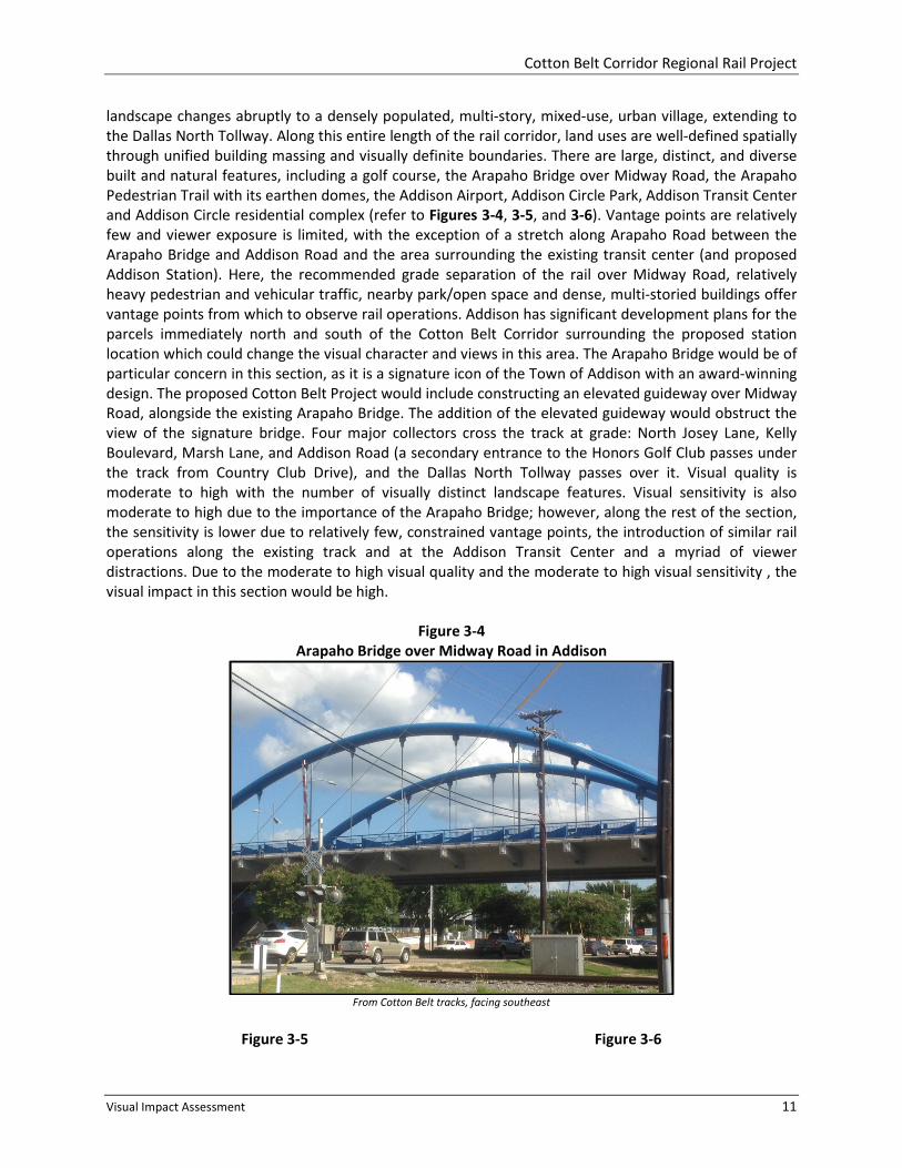
landscape changes abruptly to a densely populated, multi-story, mixed-use, urban village, extending to
the Dallas North Tollway. Along this entire length of the rail corridor, land uses are well-defined spatially
through unified building massing and visually definite boundaries. There are large, distinct, and diverse
built and natural features, including a golf course, the Arapaho Bridge over Midway Road, the Arapaho
Pedestrian Trail with its earthen domes, the Addison Airport, Addison Circle Park, Addison Transit Center
and Addison Circle residential complex (refer to Figures 3-4, 3-5, and 3-6). Vantage points are relatively
few and viewer exposure is limited, with the exception of a stretch along Arapaho Road between the
Arapaho Bridge and Addison Road and the area surrounding the existing transit center (and proposed
Addison Station). Here, the recommended grade separation of the rail over Midway Road, relatively
heavy pedestrian and vehicular traffic, nearby park/open space and dense, multi-storied buildings offer
vantage points from which to observe rail operations. Addison has significant development plans for the
parcels immediately north and south of the Cotton Belt Corridor surrounding the proposed station
location which could change the visual character and views in this area. The Arapaho Bridge would be of
particular concern in this section, as it is a signature icon of the Town of Addison with an award-winning
design. The proposed Cotton Belt Project would include constructing an elevated guideway over Midway
Road, alongside the existing Arapaho Bridge. The addition of the elevated guideway would obstruct the
view of the signature bridge. Four major collectors cross the track at grade: North Josey Lane, Kelly
Boulevard, Marsh Lane, and Addison Road (a secondary entrance to the Honors Golf Club passes under
the track from Country Club Drive), and the Dallas North Tollway passes over it. Visual quality is
moderate to high with the number of visually distinct landscape features. Visual sensitivity is also
moderate to high due to the importance of the Arapaho Bridge; however, along the rest of the section,
the sensitivity is lower due to relatively few, constrained vantage points, the introduction of similar rail
operations along the existing track and at the Addison Transit Center and a myriad of viewer
distractions. Due to the moderate to high visual quality and the moderate to high visual sensitivity , the
visual impact in this section would be high.
Figure 3-4
Arapaho Bridge over Midway Road in Addison
From Cotton Belt tracks, facing southeast
Figure 3-5 Figure 3-6
Cotton Belt Corridor Regional Rail Project
Visual Impact Assessment 12
Addison Circle Park Addison Circle Residential Complex
Addison Circle plaza and water feature, looking east Track crossing at Quorum Drive, looking northeast
3.8 Section 3-1: Dallas North Tollway to White Rock Creek
The landscape along this three-quarter mile long section transitions from multi-story office and
commercial buildings near the Dallas North Tollway to large, single-story, retail developments and multi-
family residential complexes west of White Rock Creek. There is one at-grade crossing at Knoll Trail
Drive, adjacent to the proposed Knoll Trail Station (refer to Figure 3-7). An electrical substation and
high-voltage power lines, as well as unadorned commercial building facades, are located near the
proposed station. Eastward, the Cotton Belt Corridor is fringed with vegetation. Visual quality is low and
visual sensitivity is low. Although views are limited into the station, exposure to the multi-family
residences is high; however, rail operations in an existing rail corridor would diminish viewer awareness,
so the overall visual impact is low.
Figure 3-7
Knoll Trail Drive
Track crossing at Knoll Trail Drive, looking east

Cotton Belt Corridor Regional Rail Project
Visual Impact Assessment 13
3.9 Section 3-2A (At-Grade Profile Option): White Rock Creek to Coit Road
Three design options are proposed for Section 3-2: At–grade Profile Option (Section 3-2A), Trench
Profile Option (Section 3-2B), and Tunnel Profile Option (Section 3-2C). East of White Rock Creek are a
golf course, heavily wooded open space and single-family houses to Preston Road. The proposed
Preston Road Station is located between the Fairhill School and Keller Springs Road, immediately east of
Preston Road (refer to Figures 3-8 and 3-9). Eastward to McCallum Boulevard, the corridor features
single-family housing interspersed with wooded open spaces and drainage ways, notably the McKamy
Branch East Fork, which meanders to either side of the track between Preston Road and Hillcrest Road.
From McCallum Boulevard to Coit Road, the built environment changes to moderate-to-large, multi-
family residential developments and smaller, single-story commercial buildings. High-voltage power
poles run between Preston Road and Brentfield Road where they turn east and west. The Preston Ridge
Trail crosses the track at grade at Meandering Way. Major at-grade street crossings occur at Davenport
Road, Campbell Road, Hillcrest Road and McCallum Boulevard. Coit Road would be grade separated and
elevated over the tracks. Both the proposed Preston Road Station and the Renner Village Station
(Dickerson Street and Coit Road options) are to be located at grade. The Renner Village Station option at
Coit Road will be highly visible from Coit Road and the surrounding multi-family developments (refer to
Figure 3-10). Adventure Landing Amusement Park may be displaced as part of any Coit Road option
station redevelopment.
Within this section, each land-use is defined, and the whole of the built and natural environment is
attractive and well-composed. Both visual quality and visual sensitivity are moderate. Although the
corridor is fringed with vegetation and the at-grade track bed is slightly depressed through flat terrain,
there are noteworthy views from Prestonwood Country Club, Keller Springs Park, Fairhill School, the
Preston Ridge Trail and the single-family and multi-family residences, where frequency and duration of
exposure would be great. Freight has been abandoned in this section and the existing freight tracks
would be removed. The addition of two stations would have a modest effect on the existing visual
resource; however, rail operations associated with the Cotton Belt Project would not significantly
change the existing physical environment, so the overall visual impact would be low to medium.
Figure 3-8
Preston Road
Figure 3-9
Proposed Preston Road Station Location
Intersection of Preston Road (elevated structure) and
Keller Springs Road, looking east Keller Springs Road and the Fairhill School, looking west

Cotton Belt Corridor Regional Rail Project
Visual Impact Assessment 14
Figure 3-10
Mandalay Multi-Family Residences at Coit Road
Track crossing at Coit Road, looking west
3.10 Section 3-2B (Trench Alternative): White Rock Creek to Coit Road
The second design option is known as the Trench Profile Option, for a general description of Section 3-
2B, refer to Section 3-2A. The Trench Profile Option would be located approximately one-quarter mile
east of the Preston Road Station to the proposed Renner Station at Dickerson Street. The walled trench
would gradually slope downward to a depth of approximately 10 to 15 feet. Both the proposed Preston
Road Station and the Renner Village Station (Dickerson Street and Coit Road options) are to be located
at-grade. Although the track and trains would be less visible, the overall resultant change in visual
impact would be greater due to the change in existing conditions and the resultant visibility and spatial
impact of the new construction, which would include elevated roadway crossings at Davenport Road (at
both rail crossings), Campbell Road, Hillcrest Road, McCallum Boulevard and Meandering Way.
Furthermore, Temporary visual impacts would occur during the construction of the Trench Profile
Option due to large areas of excavated dirty and large earth moving equipment associated with
construction. In areas where walls and large mounds of earth are constructed to create the Trench,
impacts would be permanent to existing views for the primary viewers in these areas. Visual impact
related to this design option would be high.
3.11 Section 3-2C (Tunnel Alternative): White Rock Creek to Coit Road
The third and final design option is known as the Tunnel Profile Option, for a general description of
Section 3-2C, refer to Section 3-2A. The tunnel is proposed to cover a portion of the Cotton Belt Corridor
within this section. Its portals would be located approximately one-half mile west of the Preston Road
Station to west of the proposed at-grade Renner Station at Dickerson Street. The Tunnel Profile Option
would be approximately 1.5 miles long, from west of Davenport Road to Meandering Way and the
Preston Ridge Trail. The proposed Preston Road Station would be located west of the Tunnel Profile
Option at the existing railroad grade. Since the track bed and trains would be less visible, the overall
change in visual impact would be low. However, temporary visual impact related to tunnel construction
would be high.
3.12 Section 3-3: Coit Road to Alma Road
Currently, the corridor east of Coit Road to Alma Road and the PGBT features several large, multi-storied
office and commercial developments north of the track and equally large agricultural tracts and sparsely
vegetated open spaces to the south (refer to Figure 3-11). East of West Renner Road, the track runs

Cotton Belt Corridor Regional Rail Project
Visual Impact Assessment 15
between multi-family residences and several large industrial developments. This area is flat with no
significant natural landmarks and highly visible in the mid-ground and background distances from the
surrounding developments, including PGBT and the University of Texas at Dallas campus. The slightly
elevated track is also visible; especially as it passes over Synergy Park Boulevard and West Renner Road
(refer to Figure 3-12). The track is crossed at grade by two major collector roadways: Waterview
Parkway and Alma Road. Coit Road would be elevated over the proposed Cotton Belt Regional Rail
Project, which would create a new view. The PGBT is less than one-half mile north of where the Coit
Road overpass would begin, however, so the predominant view in the area would remain the PGBT, as it
is higher than the Coit Road overpass would be. Also, there is additional rail activity in the area: for
example, the Kansas City Southern Railway track runs roughly north and south and passes over the
Cotton Belt Rail track about one-quarter mile west of Synergy Park Boulevard. Visual quality and visual
sensitivity are low to moderate. The proposed UTD/Synergy Park Station would be a featured element in
support of the school’s extensive UNT Dallas Campus Master Plan. As such, related viewer activities and
awareness of the Cotton Belt Rail facilities will be significant. Conversely, as part of a larger
redevelopment initiative, and experienced within the confines of the overall existing environment, the
visual impact will be low.
Figure 3-11
Coit Road
Figure 3-12
Renner Road
Track crossing at Coit Road, looking east Elevated track at Renner Road, looking southeast
3.13 Section 3-4A (Red Line Interface North Alternative): Alma Road to N
Avenue
East of Alma Road, the track turns northward through higher density, mixed-use developments,
including office parks, multi-family residences and light industry. The proposed rail alignment follows
the existing Cotton Belt Corridor and would pass under the elevated PGBT and over US 75 and Plano
Parkway. The rail alignment would pass under the elevated DART Red Line LRT guideway. The proposed,
at-grade 12th
Street Station would interface with the proposed future DART Red Line Station (refer to
Figure 3-13). Visual quality and visual sensitivity are low. Although the station and incidental
modifications to the K Avenue, Municipal Avenue and N Avenue intersections would, by degree, alter
the existing landscape, the dominant areal features would still be the elevated roadways, Red Line LRT
guideway and the power poles (refer to Figures 3-14 and 3-15). Viewer exposure and awareness from
the roadways would be limited. Composed primarily of motorists, the viewers would also experience the
Cotton Belt Project facilities as part of the much larger transportation network. Therefore, the visual
impact is low.
Cotton Belt Corridor Regional Rail Project
Visual Impact Assessment 16
3.14 Section 3-4B (Red Line Interface South Alternative): Alma Road to N
Avenue
East of Alma Road, the track turns southward on new right-of-way to pass over the Spring Creek
drainage way and the elevated US 75 before descending and turning northward to the proposed at-
grade Bush Turnpike Station. A new, aerial structure through this creek and floodplain area would result
in the loss of vegetation and create a new view for users of Spring Creek Trail and other primary viewers.
Although a new, elevated transportation facility would be added to this area, the predominant view
would remain the PGBT and US 75. The proposed Red Line Interface South Alternative is a component of
the City of Richardson’s overall development plan for the area, and the City is in support of this
alternative. This station is located adjacent to the existing at-grade DART Red Line LRT station. From
here, the track passes under PGBT and over Plano Parkway. It then passes under the DART Red Line LRT
guideway, before ascending to the proposed elevated 12th
Street Station. The City of Plano is in support
of the proposed elevated 12th
Street Station. It then descends to cross N Avenue at grade. Meanwhile,
the existing freight track would be depressed between 10th
Street and N Avenue. K Avenue and
Municipal Avenue also would be reconstructed so as to cross the freight track at grade. Visual quality
and visual sensitivity are low to moderate. Like the Red Line Interface North Alternative, viewers would
experience these changes within the context of the extensive and visually dominant network of
freeways and high-voltage power poles. Nevertheless, the Red Line Interface South Alternative, with its
elevated, undulating track and elevated 12th
Street Station, along with the depressed freight track and
roadways, would significantly alter the existing landscape in this section, which would result in a high
visual impact.
Figure 3-13
Proposed 12th
Street Station Location
Proposed 12
th Street Station location, looking west toward
Red Line LRT guideway

Cotton Belt Corridor Regional Rail Project
Visual Impact Assessment 17
Figure 3-14
Red Line LRT over Cotton Belt Alignment
Figure 3-15
PGBT over Red Line LRT
Track crossing at elevated Red Line LRT guideway, looking south Red Line LRT track crossing at elevated PGBT, looking north
3.15 Section 3-5: N Avenue to Shiloh Road
Between N Avenue and Shiloh Road, the track passes between mostly industrial developments and a
couple of multi-family residential complexes. The proposed Shiloh Station would be located immediately
west of Shiloh, and is the terminal station of the Cotton Belt Project. Jupiter Road and Shiloh Road are
the two major collector roadways crossing the track at-grade. N Avenue, which is a designated bicycle
route, also crosses at-grade. High-voltage power poles run north and south along Shiloh Road (refer to
Figure 3-16). Trackside vegetation is sparse and the natural terrain is flat and featureless, but viewer
exposure is limited by the many single-story industrial buildings and few vehicular track crossings. Visual
quality and visual sensitivity are low. Given the existing environment and limited viewer exposure,
except at the station that would generate some pedestrian activity, the visual impact is also low.
Figure 3-16
Electrical Substation at Shiloh Road
Track crossing at Shiloh Road, looking west

Cotton Belt Corridor Regional Rail Project
Visual Impact Assessment 18
4.0 POTENTIAL MITIGATION OPTIONS
As described in FHWA’s Visual Impact Assessment for Highway Projects, mitigation “encompasses the
enhancement of positive effects as well as the reduction or elimination of negative effects”. Mitigation
measures are intended to “alleviate the effects of resource utilization, upgrade visual resource quality to
some standard, and offset adverse visual impacts.” According to DART’s Environmental Impact
Assessment and Mitigation Guidelines for Transit Projects, “The appropriate approach to mitigation of
visual impacts is heavily dependent on the characteristics of each area through which the transit project
will pass. Potential solutions are dependent upon the set of problems given the designer.” Furthermore,
mitigation measures are intended to satisfy the following overall objectives as they affect visual quality:
• The design, location, construction, materials and finishes of each Cotton Belt Project element,
including station amenities, trackwork, landscaping and landforms, shall complement the
character of their surroundings, as well as the visual character of the region.
• Proposed elements shall be designed to take advantage of attractive, existing site features and
be compatible with surrounding land uses and developmental patterns.
• Proposed elements shall be designed to foster the enhancement of surrounding land uses and
joint, transit-oriented development.
• Proposed elements shall be readily identifiable, easy to understand and use.
• Proposed elements shall comply with state and local jurisdictional requirements, laws and
codes, as well as national standards and regulations. They include the Americans with
Disabilities Act (ADA) and the latest editions of the Building Officials and Code Administrators
International (BOCA) Code, the National Fire Protection Association (NFPA) 130 Standard for
Fixed Guideway Transit Systems and the Uniform Building Code (UBC). Where no provisions are
applicable, the best engineering and architectural practices shall be followed.
• Proposed elements shall help to establish a cohesive visual identity for all the stations
throughout the system.
• Proposed elements shall help to reduce the impact of unattractive surroundings and visual
resources, and to provide privacy for adjacent land uses.
• Proposed elements shall enhance attractive views.
• Generally accepted visual resources, such as existing landforms and vegetation, shall be
preserved whenever possible.
Potential mitigation options may take the form of screening, enhancing and preserving a visual resource.
Conversely, it may require screening, removing and re-locating a proposed element or vantage point.
Also, it may require limiting or extending viewer exposure to the visual resource. The following are
potential mitigation options specific to the visual resources described previously for each section of the
alignment, if a potentially significant or significant visual impact has been identified:

Cotton Belt Corridor Regional Rail Project
Visual Impact Assessment 19
Section 1-1: No significant visual impact identified and no mitigation recommended, except to preserve
and augment the existing Cottonwood Branch stream bank.
Section 1-2A: To minimize the impact to adjacent residential viewers, the elevated rail guideway over
Denton Tap Road would be reduced in height to the extent practicable. Efforts should be made to retain
existing vegetation along the edge of the Cotton Belt Corridor to provide a visual buffer between the
neighborhood and the rail alignment. Selection of the Cypress Waters Alternative would eliminate the
potential for visual impact to the Chateaus of Coppell neighborhood.
Section 1-2B (Cypress Waters Alternative): No significant visual impact identified and no mitigation
recommended at this time. As development occurs, the potential visual impacts of the proposed project
may require re-evaluation.
Section 1-3: Screen with vegetation the existing track from views from the Riverchase Golf Course and
the residential developments, in keeping with the character and density of the existing wooded areas;
likewise, buffer with vegetation East Belt Line Road.
Section 2-1: No significant visual impact identified and no mitigation recommended.
Section 2-2: Design the architectural, landscape architectural and spatial character of the Downtown
Carrollton Station to reflect those of the existing transit facilities, the nearby historic neighborhood and
the system-wide character of the corridor; screen with vegetation the existing track from views from the
historic residential district to the east; buffer with vegetation the Hutton Branch Trail; develop nearby
under-utilized and vacant parcels to complement the transit-oriented development; and preserve and
augment the existing Hutton Branch Creek stream bank.
Section 2-3: Use vegetation to screen the existing track from the Honors Golf Club, Polk Middle School
athletic fields and the residential developments, in keeping with the character and density of the
existing wooded areas; likewise, buffer with vegetation Arapaho Road. To minimize the adverse visual
impact of the elevated guideway on the Arapaho Bridge, the aerial structure could be designed to
complement the Arapaho Bridge and/or the height of the aerial structure could be minimized to the
extent practicable. Design the architectural, landscape architectural and spatial character of the Addison
Station to reflect those of the existing transit facilities, Addison Circle and the system-wide character of
the corridor; and architecturally augment the major roadway crossings in such a way as to support a
unified visual character for the entire transit corridor.
Section 3-1: Screen with vegetation the existing track from views from the multi-family residential
developments, in keeping with the character and density of the existing wooded areas; screen with
vegetation the existing electrical substation from the proposed Knoll Trail Station.
Section 3-2A (At-grade Alternative): Screen with vegetation the existing track from views from the
Prestonwood Country Club and the residential developments, in keeping with the character and density
of the existing wooded areas, notably Kelly Springs Park and the McKamy Branch East Fork; screen with
vegetation the proposed Preston Road Station from the Fairhill School and grounds; architecturally
augment the major roadway crossings and Preston Ridge Trail in such a way as to support a unified
visual character for the entire transit corridor; and preserve and augment the existing White Rock Creek
Cotton Belt Corridor Regional Rail Project
Visual Impact Assessment 20
and McKamy Branch East Fork stream banks. DART’s removal of the freight tracks in this freight-
abandoned section would also provide visual mitigation in this section of the proposed project.
Section 3-2B (Trench Profile Option): Refer to Section 3-2A; enhance the architectural character of the
six proposed elevated roadway crossings; and preserve existing vegetation as much as possible along
the track during trench construction. Selection of either the At-Grade Profile Option or the Tunnel
Profile Option would eliminate the visual impact of the six elevated roadway crossings.
Section 3-2C (Tunnel Profile Option): Refer to Section 3-2A; In addition, mitigation for the Tunnel Profile
Option would include preservation of existing vegetation as much as possible along the track during
tunnel construction and re-vegetation of disturbed areas after construction is complete.
Section 3-3: No significant visual impact identified and no mitigation recommended, except to preserve
and augment the existing Prairie Creek stream bank.
Section 3-4A (Red Line Interface North Alternative): Design the architectural, landscape architectural
and spatial character of the 12th
Street Station to complement those of the adjacent existing transit
facilities and the system-wide character of the corridor; and preserve and augment the existing Spring
Creek stream bank.
Section 3-4B (Red Line Interface South Alternative): The visual impacts of the new-location aerial
guideway through Spring Creek and its associated floodplain could be mitigated by minimizing the
height of the elevated structure, minimizing the number of piers placed through the vegetated area, and
designing the structure to complement the natural environment. Additional mitigation for users of the
Spring Creek Trail could include tall vegetation along the trail to screen the new aerial structure from
view. To mitigate visual impacts of the elevated 12th
Street Station, design the architectural, landscape
architectural, and spatial character of the 12th
Street Station to complement those of the adjacent
existing transit facilities and the system-wide character of the corridor. As new development occurs in
this area, potential visual impacts and mitigation measures could require re-evaluation.
Section 3-5: No significant visual impact identified and no mitigation recommended, except to
architecturally augment the major roadway crossings in such a way as to support a unified visual
character for the entire transit corridor.
Alliance Transportation Group
Arredondo, Zepeda & Brunz
Bowman Engineering
Connetics Transportation Group
Cox|McLain Environmental Consulting
CP&Y
Criado & Associates
Dunbar Transportation Consulting
HMMH
KAI Texas
K Strategies Group
Legacy Resource Group
Mas-Tek Engineering & Associates
Nathan D. Maier Consulting Engineers
Pacheco Koch Consulting Engineers
Parsons
Schrader & Cline
Spartan Solutions
Stantec Consulting Services Inc.