César Caviedes University of Floridaclagscholar.org/wp-content/uploads/2014/04/caviedes.pdf ·...
19
César Caviedes University of Florida Natural Hazards in Latin America: A Survey and Discussion With a few remarkable exceptions, research on natural hazards in Latin America has been of minor concern to North American geographers. There seems to exist a certain indifference among the established specialists toward the hazards that strike Latin American countries, and the reasons for this attitude appear to stem from a strongly European or North American-centered environmental perspective and from an apparent lack of interest in the natural catastrophes that afflict countries of alien cultural traditions (Waddell, 1977, 73). Middle and South America are among the areas of the world most frequently struck by natural hazards, and this disaster proneness needs to be underlined because it has ecological and economic implications whose effects are felt not only within the regional boundaries but also on international levels. The Physical Background of Natural Hazards As a result of their geological conditions and due to the fact that most of their continental masses lie in tropical latitudes, South and Middle America are highly susceptible to devastating ecological disruptions. The Andes and the Central American cordilleras are mountain systems built along plate boundaries where crustal deformation results often in orogenic uplift, tectonic activity and volcanism. This particular structural situation explains the high concentration of geological hazards on the western margins of the Americas (Figure 1).
Transcript of César Caviedes University of Floridaclagscholar.org/wp-content/uploads/2014/04/caviedes.pdf ·...
César Caviedes University of Florida
Natural Hazards in Latin America: A Survey and Discussion
With a few remarkable exceptions, research on natural hazards in Latin America has been of minor concern to North American geographers. There seems to exist a certain indifference among the established specialists toward the hazards that strike Latin American countries, and the reasons for this attitude appear to stem from a strongly European or North American-centered environmental perspective and from an apparent lack of interest in the natural catastrophes that afflict countries of alien cultural traditions (Waddell, 1977, 73). Middle and South America are among the areas of the world most frequently struck by natural hazards, and this disaster proneness needs to be underlined because it has ecological and economic implications whose effects are felt not only within the regional boundaries but also on international levels. The Physical Background of Natural Hazards As a result of their geological conditions and due to the fact that most of their continental masses lie in tropical latitudes, South and Middle America are highly susceptible to devastating ecological disruptions. The Andes and the Central American cordilleras are mountain systems built along plate boundaries where crustal deformation results often in orogenic uplift, tectonic activity and volcanism. This particular structural situation explains the high concentration of geological hazards on the western margins of the Americas (Figure 1).

Even though the broad-scale features of the Andes were already established in the Miocene-Pliocene (Dollfus, 1973, 160), subsequent orogenic uplifts in certain areas of the mountains particularly in Peru, Ecuador, Colombia, and Venezuela --caused strong river downcutting and deep valleys in the massive body of the Andes. In these narrow corridors there was intense alluviation during the

glacial/pluvial periods of the Quaternary. The steep Andean valleys are the collectors of glacio-fluvial deposits from the glaciated high mountains and the evacuation alleys for fluviovolcanic materials such as lahars, avalanches, and mud flows. This makes the Andean valleys in areas of frequent volcanic activity enormously catastrophe-prone and more so when these valleys are the most densely populated areas of the tropical high mountains of the Americas. Another hazard is represented by the fact that many of the active and dormant volcanoes are the highest summits and the most glaciated areas and that, therefore, morainic systems or cinder flows tend to form fragile barriers that easily give way .in periods of eruption or seismic shattering (Scheidegger, 1975, 167; 173). Settlements in Middle America and along western South America exhibit a gloomy record of seismic disasters. From the early periods of colonization until the present, villages, towns, and cities have been destroyed repeatedly by devastating earthquakes; there is not one capital city in the Andes or in the Middle American cordillera that has not been struck at least once in the course of its history, with Managua and Guatemala City being the latest (Haas, Kates, and Bowden, 1977, passim). Volcanism in Middle and South America has an infamous record as a disaster generator in the four major areas of volcano concentration: Guatemala, Nicaragua, and Costa Rica; the volcanic axis of the Antilles; in the Ecuadorian cordillera; and in the Chilean Andes. The most damaging effects from lava flows, gas explosions, ignimbrites, and cinder rains have been felt in Middle America and the Antilles, since in both regions human settlements are concentrated very close to the foci of active volcanism (Rees, 1979, 249-292). This population concentration is due, to a large extent, to the optimal capacity of the soils that have developed on effusive materials. Another structural circumstance, namely its location on the eastern edge of the Pacific Ocean, exposes South America's western seaboard to tsunamis, tidal waves of seismic origin. Current theories associate tsunamis with submarine slides or large dip-slip displacements along convergent boundaries, like the one on the western coast of South America, and with spreading centers, like the East Pacific Ridge (lsacks, Oliver, and Sykes, 1968, 5881-5889). Thus, from the Pacific coast of Colombia to the southern tip of continental Chile, tsunamis have had catastrophic consequences in historical times. The coast of Jalisco, where the East Pacific Ridge intercepts the San Andreas Fault, has been frequently hit by

tidal waves and so has the western coast of Middle America. Almost no research has been conducted on the subject. All of Middle America, the Antilles, and two-thirds of South America's surface are located between the tropics and are subject to the climatic effects of the equatorial, tropical, and subtropical atmospheric circulation. It has been established lately that the patterns of atmospheric circulation in the equatorial belt are not as regular as we used to think (Flohn and Fleer, 1975, 96-108). Climatic fluctuations, usually in the form of rainfall anomalies, extensive floods, or drought spells are frequently linked with oceanic anomalies of sizeable dimensions and a good example of this is the El Niño phenomenon. Since Middle and South America have the greater proportion of their population concentrated in marginal belts no more than 300 kilometers from the coast, the effects of whatever climatic-oceanic anomalies may occur in the vastness of the tropical Atlantic or Pacific will be strongly felt by these "peripheral" populations. Slight variations of the energy budget in the equatorial zone are frequently paralleled by catastrophic events in the tropics such as heavy rains, floods, droughts, and ensuing epidemics. Subtropical South America, on the other hand, is by no means safe from climatic hazards. The mid-latitudes of Chile and Argentina are prone to prolonged droughts due to their location at the margins of subtropical anticyclones and the effects of such situations are devastating on the agriculture of mediterranean Chile (Schneider and Peña, 1975, 111-116) or on the wheat farming of the Argentinean pampas (Prohaska, 1961, 53-67). A widespread drought condition over the entire southern cone of South America is common in winters when the strengthened high pressure cells of the Pacific and Atlantic are connected by a powerful ridge across the Andes (Caviedes, 1974, 4). No less deleterious are the effects of outbreaks of cold air masses, associated with the passage of abnormally strong subantarctic fronts, on the agricultural economy of the subtropical margins of South America (Lauer and Breuer, 1976, 16-30). Killing frosts have repeatedly ruined the yerba mate plantations of the La Plata lowlands, and in 1975 a cold outbreak damaged the coffee fields of southern Brazil. The pulsating strength of the subtropical anticyclones is also responsible for catastrophic winter rains, which may affect subtropical South America in years when the weakened high pressure cells allow an abnormally high frontogenesis in

the southeastern Pacific (Weischet, 1968, 177-186). Landslides, mudflows, and floods are common sequels to bad-weather spells that affect central Chile under the circumstances mentioned above. A general survey of the natural hazards related to particular meteorological conditions would not be complete without a reference to the hailstorms on the Andean slopes of Argentina. Frontal passages are probably accentuated by the waves of trans-Andean airflow to produce unusually strong convection over the lower eastern slopes of the Andes (Capitanelli, 1967, 204). The ensuing hail development is often destructive for the vineyards of Mendoza, the largest wine-producing area in Latin America. As to the devastating hurricanes in the Caribbean, on the other hand (Bowden, 1974), the danger they represent for the lives and economy of the south of the United States has prompted an impressive number of studies (Mileti, 1975, 32-33). The Effects of Natural Hazards in Latin America For the traditional school of hazard research -- Burton, Kates, Mitchell, White and others -- a natural catastrophe warrants, geographical study if it meets the following specifications: 1) it corresponds to an alteration of natural systems; 2) it inflicts damages and losses upon society; 3) it is perceived by man as a negative event; 4) it elicits personal or collective responses; and 5) it prompts worldwide attention and international aid (White, 1974, 3-15). With these requirements being met by most of the catastrophic events outlined in the preceding section, one wonders why none of the researchers mentioned has made reference to them. In order to underline the social, economic, and political implications of major natural catastrophes in Latin America and to examine the related human adjustments, three cases will be reviewed. All of them comply with the general norms for the natural hazard worth its "academic value," and two had particularly far-reaching effects in that they upset, for a while, the international economy. The Callejón de Huaylas Tragedies: 1962, 1970 Impressive in their dimensions and tragic in their consequences the avalanches of Yungay, in the Andes of central Peru, are textbook examples of geological catastrophes. Structural and climatic circumstances join in dangerous combination to make the Callejón de Huaylas highly hazard-prone: the name

callejón (narrow alley) depicts the physiographic features of the Santa Valley, which is trenched along an active fault line between the Cordillera Negra and the Cordillera Blanca. Numerous tributaries springing from glacier snouts in the Cordillera Blanca empty into the Santa Valley. By reason of its fertile alluvial soils and because the valley flanks are too steep to allow for settlements, the valley floor has been populated since pre-Hispanic times. Owing to their location in subequatorial latitudes (8-10 degrees S), the summits of the Cordillera Blanca, such as the Nevado Huascaran and the Nevado Huandoy, have developed icefields characterized by rapid accumulation and ablation that are enhanced by the sustained high insolation in the Andean peaks. Rapid alternation of snowfall and melt make the icefields extremely unstable; this, added to the very steep upper slopes, increases the threat of sudden ice or rock avalanches. Even light tremors -- frequent along fault lines -- have triggered landslides, mudflows, or avalanches along the tributary valleys with catastrophic consequences. In 1941 the collapse of a natural dam -- a terminal morainic loop -- resulted in a mudflow that buried half of the town of Huaras and four thousand of its inhabitants. On January 10, 1962, at the end of a sunny summer day, three million tons of ice from Glacier 511 were set in motion by a tremor; in their descent they carried with them two million tons of rock debris and mud. Eight hundred and twenty lives were lost in the shepherd villages of Pacucco and Yanamachico even before the avalanche obliterated and buried the valley villages of Ranrahirca, Huarascucho, Chuquibamba, and Uchucoto, claiming 2,713 more lives. Following the inflections of the Shacsha Valley the mass of ice, debris, and mud moved at about one hundred kilometers per hour, and did not come to a halt until it reached the banks of the Santa River. At Ranrahirca the avalanche was twenty meters thick (Dollfus and Penaerrera del Aguila, 1962; 3-18). The 27,000 inhabitants of Yungay, the central place of the Callejón de Huaylas, did not share the tragic destiny of the neighboring village of Ranrahirca on this occasion. On May 30,1970, however, an earthquake of unusual intensity (reading 6 on the Richter scale) shook the Callejón de Huaylas, crumbling many of the modest houses of Yungay. Less than two minutes later, an avalanche of snow and mud, travelling at close to 300 kilometers per hour, buried the whole town and 25,000 of its inhabitants. This time an enormous mass of fifteen million tons squeezed along the narrow floor of the Shacsha Valley and its upper layer was able to spill over the rocky spur that had saved Yungay in 1962 (Jatzold, 1971, 108-117). As a
measure of comparison, the Alaska earthquake of 1964 claimed 131 lives and Hurricane Camille left 256 dead in 1969. The repetition of catastrophic events with tragic consequences, in the same place and only eight years apart, challenges the patterns of hazard response put forward by the specialists, who state that inhabitants of hazard-prone areas learn from natural catastrophes like this one, that they react by moving away from the dangerous sites or by requesting government assistant in order to be able to resettle (Burton, Kates and White, 1978, 34-49). In the Callejón de Huaylas similar catastrophes in 1941 and 1962 had done little to convince people that they were living in a hazardous environment and, as reported by Doughty (1971, 232-234) active urban and artisan development had occurred in the area during those eight years. Loss of lives, buildings, and cropland did not persuade government agencies either to adopt resettlement policies or to at least start monitoring the equilibrium in ice masses and dammed lakes. A question that remains unanswered after the obliteration of Yungay is why, since the survivors of the previous avalanches did not realize the danger that hovered above their heads, those who knew did not do anything about it. The traditional school of hazard research did not seem eager to answer this poignant question of persistent occupation of a hazardous site by a traditional society, but the sociologists were prompt in recording and analyzing place perceptions and patterns of social behavior and class relations altered by the catastrophic event (Oliver-Smith, 1977a, 7-13). International Coffee Prices and Frost In Southern Brazil Outbreaks of cold air during winter are well known in the Pampas of Argentina, but they are less common as one moves north of the River Plate. Unusually strong cold air masses, friagems, however, can invade the uplands of the Paraná Basin and inflict considerable damage upon this major coffee-producing area of Brazil. Coffee constitutes the main export commodity of Brazil (44 percent of all exported goods) and the country is the major supplier of the international market (45 percent during the 1960s and 26 percent during the 1970s). The drastic reduction of Brazil's percentage during the 1970s stems partially from the International Coffee Agreement (lCA) of 1963 which, along with other measures to stabilize the international marketing of coffee, introduced the quota system
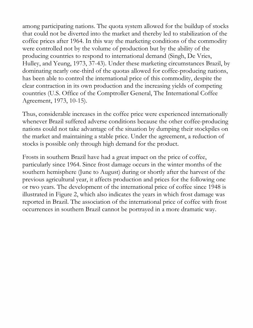
among participating nations. The quota system allowed for the buildup of stocks that could not be diverted into the market and thereby led to stabilization of the coffee prices after 1964. In this way the marketing conditions of the commodity were controlled not by the volume of production but by the ability of the producing countries to respond to international demand (Singh, De Vries, Hulley, and Yeung, 1973, 37-43). Under these marketing circumstances Brazil, by dominating nearly one-third of the quotas allowed for coffee-producing nations, has been able to control the international price of this commodity, despite the clear contraction in its own production and the increasing yields of competing countries (U.S. Office of the Comptroller General, The International Coffee Agreement, 1973, 10-15). Thus, considerable increases in the coffee price were experienced internationally whenever Brazil suffered adverse conditions because the other coffee-producing nations could not take advantage of the situation by dumping their stockpiles on the market and maintaining a stable price. Under the agreement, a reduction of stocks is possible only through high demand for the product. Frosts in southern Brazil have had a great impact on the price of coffee, particularly since 1964. Since frost damage occurs in the winter months of the southern hemisphere (June to August) during or shortly after the harvest of the previous agricultural year, it affects production and prices for the following one or two years. The development of the international price of coffee since 1948 is illustrated in Figure 2, which also indicates the years in which frost damage was reported in Brazil. The association of the international price of coffee with frost occurrences in southern Brazil cannot be portrayed in a more dramatic way.

The frost of 1975 offers a valuable insight into the fashion in which this natural hazard in South America influenced the international price of coffee. At the end of 1974, the price had oscillated around 70 cents per pound, a relatively low figure considering the inflationary surge unleashed by the oil crisis of 1973. Early in 1975 the price prospects for the ICA nations were bleak and this led to dissension about pricing policies (New York Times, April 26, 1975, 39). The July 1975 cold wave in Brazil was not reflected in an immediate increase of the coffee price because at that time of the year sales were still being conducted according to the quotas established the year before. Nevertheless, by the end of the year the price of coffee climbed steadily: $1.00 in January, $1.50 in June, $2.00 at the end of the year. This upward trend took on a feverish pace between January and April of 1977, when the price for coffee jumped from $2.20 to an all-time high of $3.34. After this, the price went down again to slightly over $2.00 for the rest of 1977, and then down to $1.58 in May of 1978 (World Agricultural Situation, 16 July 1978, 1314). It is difficult to argue that the soaring coffee prices of 1976-1977 were a consequence of the inflationary trend triggered by the 1973 oil crises. Although Brazil is highly dependent on foreign oil supplies to maintain its industrial development, the rise in fuel prices in 1973 and 1974 was not coincident with an increase of the price of coffee as one might have expected. The fact that coffee prices soared after an ecological crisis that put out of production 55 to 70 percent of the coffee trees is proof that the high price for
this commodity was not precipitated by political or economic events elsewhere. As in the case of the Callejón de Huaylas tragedy, frost damages in the coffee fields of southern Brazil and their socioeconomic implications have gone unnoticed by the establishment in natural hazard research, but not by other social scientists. Margolis (in press) mentions that in years of extreme frost small coffee planters surrender their landholdings to powerful ranchers and become dependent laborers. Hence, the frost hazard, whose international implications were outlined above, also has deep local implications, for it changes land tenure patterns and upsets labor relations in rural communities. No matter how much discussion there exists about hazard perception, hazard experience, hazard warning, and national policies, the South Brazilian friagems will recur and coffee consumers worldwide will have to bear the brunt of an economic situation triggered by a natural hazard and very little under control by the existing world economic system. The Effects of El Niño on the Economy and the Politics of Peru The occasional invasions of warm water and equatorial air masses along the coast of northern Peru, referred to as the El Niño phenomenon, are among the most dramatic ecological disturbances in South America. Life in the ecosystem of the cold Peruvian Current is very much upset in the years when El Niño strikes. On-land structures as well as cultivated fields are damaged by the copious rains that accompany the invasion of warm water. A complex set of disturbed ecological interactions develops during these special years, with effects not only on nature but also on man and his works (Caviedes, 1975, 493-509). Due to the climatic and oceanographic features and also to the extra-regional implications of the phenomenon, El Niño has attracted the interest of noted meteorologists, such as Bjerknes, Flohn, Namias, and Bryson, and of oceanographers such as Quinn, Wooster, and Wyrtki. The fascination with El Niño is not confined, however, to natural scientists; sociologists and political scientists have underlined that the event prompts social and political responses as well. A forthcoming book under the editorship of Michael Glantz focuses on the multiple and global effects of El Niño upon man, ecology, and economics. However, the interest shown in this topic by geographers has been minimal, and
the literature produced by the establishment on natural hazard research contains not a single reference to the ecological and economic consequences of an El Niño event. The last time El Niño struck the western coast of South America, in 1972-73, its effects on the socio-economic state of Peru were such that the government was forced to step in. In the oases of the northern Peru desert heavy rains had both negative and positive effects. Floods, silting, and bank erosion permanently or temporarily disabled valuable cropland; on the other hand, a blooming of natural pastures was effected by the rains, which made cattle breeders of the region realize that, with adequate irrigation programs, some unutilized lands in valley tracts might be advantageously used for cattle raising. Even though irrigation schemes in these areas would be costly, it is even more expensive for Peru to import cattle in order to cover the chronic and acute meat shortage suffered by the country. It was, however, the oceanic anomalies of El Niño that had the greatest impact on Peru's economy and politics. The invasion of equatorial waters brought about a drastic contraction of the anchovy stock and a consequent slump in the landings of fish used for the production of fish meal, Peru's first export commodity. Until 1972 the Peruvian fisheries had expanded without government control and without concern for the conservation of the fishing stocks in the Peruvian Current. In 1970 a panel of specialists which had analyzed the fishing situation of Peru warned that the speculative character of the fish meal industry could lead to the depletion or even exhaustion of the anchovy stock. On that occasion it was also remarked that the hunger for fast profits had created a surplus of installed fishing capacity that could seriously endanger the recovery of the stocks in the event of an ecological crisis. Further, the panel recommended a reduction of the fishing fleet and the processing plants by one-fourth in order to make the operation to the industrial fisheries more rational and to avoid a final collapse (Peru, Instituto del Mar, 1970, 35-40). With the fishing fleet and the plants entirely in hands of national and international capitalists, the ecological plea was not heeded. The landings of anchovies reached a record high of 12,475,946 metric tons in 1970 and fell only to 10,389,784 tons in 1971. One year later the sudden disappearance of the anchovies caused such a contraction in fish meal production that many small plants, unable to cope with maintenance costs, went bankrupt. In May 1973, as

the anomalous oceanic condition of El Niño persisted, the Peruvian government nationalized all fishing vessels and fish meal plants (Caviedes, 1975, 499-500). This move brought under state control, with all its advantages and disadvantages, Peru's most lucrative, but also most fragile primary industry. It represented a new thrust in the nationalization trend which the military government, headed by General Velazco Alvarado, had initiated in the late 1960s with the expropriation of the oil fields around Talara. Since Peru's fish meal supplied about half of the international demand for the product in the early 1970s, the slump in its production and the consequent rise in price diverted the demand to alternative sources of protein-rich animal feed (Vondruska, in press). Particularly strong was the pressure on soybeans. Their price reached the maximum for the decade of $470 per metric ton in June 1973 (Figure 3), at precisely the time when the effects of El Niño on the Peruvian fisheries were being felt on the world market.

These price increases for fishmeal and soybeans, and, consequently for beef, at the international level are examples of influence of a regionally localized ecological disturbance. The climatic anomalies that led to the El Niño condition on the western coast of South America were, moreover, of worldwide extent. They coincided with serious droughts in Africa (Sahel, Ethiopia), the Soviet Union, India, China, South Africa, Australia, and Northeast Brazil, and with abnormally heavy rains in the Philippines and in the Mediterranean area. Under these circumstances, agricultural output of the world was poor and the demand for grain was not met. Critical food production and the oil crisis in 1973 caused the world economy to be caught in the inflationary updraft which could be regarded as one of the causes for the restlessness that characterized the international situation of the 1970s. Still, if El Niño were to be denied its far-reaching environmental implications by
the argument that its effects have become more visible and tangible only after the inception of modern fisheries on the western coast of South America, archeological evidence and historical testimony indicate that past El Niños were of such ecological impact as to prompt important cultural responses. According to Parsons and Psuty (1975, 279-281) the development of sunken-field agriculture in the river oases of coastal Peru appears to have originated in the convenience of using excess runoff stored during periods of intensified rains-a typical sign of an El Niño event. More recently Smith (1979, 399) has suggested that the agricultural use of sunken fields benefitted greatly from the increased water reserves in flood plains stemming from the rains of El Niño years. These suggestions make it clear that the time dimension cannot be neglected in hazard research. Once again, the established school of natural hazard research has failed to underline the value of historical reconstructions in assessing the intensity of ecological disruptions and the cultural implications of catastrophe occurrence (Torry, 1979, 369). Natural Hazard Research in Latin America: Whither Now? The summary review and case studies of hazards in Latin America outlined above raise questions about the conceptual approach of this branch of geography and about the degree of information exhibited by the establishment in natural hazard research. It is inexcusable, though in line with their parochial perspectives, that hazardous events such as those outlined above have been ignored or have gone unnoticed in the writings of Burton, Kates, Mitchell, and White, all of whom are geographers. Repeated omissions of the studies on environmental crises produced by Latin Americanists not only in the field of geography but also in sociology and anthropology cast serious doubts on the value of their generalizations when writing about social responses and group adjustments to hazard situations. As Torry points out – and rightly so – a comprehensive survey of hazard-prone areas in the world has not been completed and the establishment in the field has notoriously failed to match their findings and philosophical premises with those of other disciplines in social sciences (Torry, 1979, 368-369). In addition, it is senseless to attempt cross-cultural interpretations or to use cross-national models of hazard perception and heard response if the avenues of information have not been exhausted or even explored, as in the case of Latin America.

Studies on site hazardousness and analyses of hazard perception and responses have often been carried out by the specialists with a great deal of pragmatism, academic aloofness, and ethnocentricity (Mitchell, 1980). Starting with the assumption that local or national finances can cover the costs of hazard monitoring, hazard prevention, and hazard adjustments, the researchers have devoted their attention almost exclusively to affluent countries and have tended to think in terms of managerial and technical solutions. Faith in technology has made them place more emphasis on the economic aspect of a catastrophe than on its social and political implications. Affluence permits economic responses (insurance schemes) to cope with material losses and frequently allows the provision of relief funds for the construction of protective structures and for relocation projects. But what about countries where such responses are not possible due to economic backwardness, traditional cultural attitudes, and political apathy? Is it right to neglect them or consider them worthy only of secondary attention simply because their natural catastrophes do not command the same degree of attention from their leaders and inhabitants as in affluent countries? It appears that only if a natural catastrophe is too big to be ignored (as in the case of the 300,000 deaths from the Bangladesh cyclone in 1970) will the developed nations grant technical assistance in hazard monitoring and hazard prevention (Burton, Kates, and White, 1978, 165). This attention is seldom bestowed, however, upon catastrophes in which the death toll is not appalling or where damages do not amount to many millions of dollars. The repeated tragedies in the Callejón de Huaylas, for instance, not even mentioned in the literature of the experts on hazards, raise serious objections about the degree of humanitarian commitment and the relevance of the work done by these experts in developed countries. The 1962 and 1970 catastrophes have demonstrated that many valleys like this one in the Andes must be recognized as extremely hazard-prone and that careful mapping as well as surveys on catastrophe perception are needed in potentially dangerous sites. Oliver-Smith, a sociologist, has stated that in spite of considerations such as the hazard proneness of a place, repeated tragedies, and losses of lives, the survivors of the Yungay disaster refused to have their town rebuilt in a different part of the Callejón de Huaylas, because for them (the Yungainos) the old site of Yungay was the most suitable place to conduct the rural-urban exchanges that are so characteristic of traditional peasant cultures in the Andes. Oliver-Smith was, in
fact, able to prove that by again choosing a hazardous site for their new town the Yungainos were acting rationally and that their place perception corresponded exactly to the postulates of central place theory (Oliver-Smith, 1977b, 112-115). What a lesson have we been taught by our fellow social scientists! If the existence of dangerous sites and the socioeconomic as well as sociocultural implications of hazard situations are disregarded by geographers, one can hardly expect greater awareness and action from politicians or international functionaries. An individual whose life and subsistence are endangered by a hazardous environment deserves as much attention as the individual who is threatened by political repression. It is regrettable that the only way to make us concerned about critical ecological situations affecting our fellow man in far-off poorer countries is to suffer a few cents' increase in the price of our tenderloin or our cup of coffee. It seems very clear that if the established figures in hazard research continue to ignore serious environmental problems in Latin American countries, it is our responsibility as Latin Americanist geographers to call attention to the existence of such critical environmental situations. I am not criticizing the diligence of Latin Americanist geographers, for their contribution to knowledge in the field has been, so far, a useful one. My critique is aimed at the establishment in natural hazards for having failed to incorporate into the mainstream of the discipline the numerous and valuable contributions of scholars from neighboring sciences. References Cited Bowden, M.J. Hurricanes in Paradise: Perception and Reality of the Hurricane Hazard in the Virgin Islands. (St. Thomas: Island Resources Foundation, 1974). Burton, I., R.W. Kates, and G.F. White. The Environment as Hazard. (New York: Oxford University Press, 1978). Capitanelli, R. "Les bases d'une classification genetique des climats de l'Argentine," in J.A. Sporck (ed.) Melenges de Geographie Physique, Humaine, Economique, Appliquee offerts a Omer Tulippe, Vol. 1. (Gembloux Editions J. Duculot, 1967). Caviedes, C. "Natural Hazard Research on South America: Bias or Ignorance" Annual Meeting of the Canadian Association of Geographers, Programme et Resumes.

(Quebec: Universite Laval,1976), 18-19. Caviedes, C. "El Niño 1972: Its Climatic, Ecological, Human, and Economic Implications," The Geographical Review, Vol. 65 (1975), 493-509. Caviedes, C. "Climatic Hazards in Tropical and Subtropical South America," (paper presented at the Boca Raton meeting of the Conference of Latin Americanist Geographers, 1974). Dollfus, O. "La Cordillere des Andes. Presentation des Problemes Geomorphologiques," Revue de Geographie Physique et de Geologie Dynamique, Vol. 15 (1973), 157-176. Dollfus, O. and C. Penaherrera de Aquila. "La destruccion de Ranrahirca el 10 de enero de 1962," Boletín de la Sociedad Geográfica de Lima, Vol. 79 (1962), 3-18. Doughty, P. "From Disaster to Development," Americas, Vol. 23 (1971), 232-235. Flohn, H. and H. Fleer. "Climatic Teleconnections with the Equatorial Pacific and the Role of Ocean-Atmosphere Coupling," Atmosphere, Vol. 13 (1975), 96-109. Glantz, M. (ed.) Fisheries Management and Environmental Uncertainties: El Niño and the Anchoveta (New York: John Wiley and Sons, in press). Haas, J.E., R.W. Kates, and M.J. Bowden. Reconstruction Following Disaster. (Cambridge: MIT Press, 1977). Isacks, B., J. Oliver, and L.R. Sykes. "Seismology and the New Global Tectonics," Journal of Geophysical Research, Vol. 73 (1968), 5855-5899. Jatzold, R. "Die verschutte Stadt Yungay, Peru," Die Erde, Vol. 102 (1971), 108-117. Lauer, W. and R. Bueuer. "Das Wettersatellintenbild. Beispiele seiner geographischen Aussagemoglichkeiten," Forschungsberichte des Landes Nordrhein-Westfalen Nr. 2556. (Dusseldorf: Westdeutscer Verlag, 1976). Mileti, D.S. Natural Hazard Warning Systems in the United States. (Boulder: University of Colorado, 1975).
Mitchell, J. K., Alternative Paradigms for the Investigation of Collective Responses to Hazard: An Outline." (Draft of paper read at the 76th Annual Meeting of the Association of American Geographers, Louisville, 1980). Oliver-Smith, A. "Disasater Rehabilitation and Social Change in Yungay, Peru," Human Organization, Vol. 36 (1977a), 5-13. Oliver-Smith, A. "Traditional Agriculture, Central Places, and Post-disaster Urban Relocation in Peru," American Ethnologist, Vol. 4 (1977b), 102-106. Parsons, J.R. and N.P. Psuty. "Sunken Fields and Pre-Hispanic Subsistence on the Peruvian Coast," American Antiquity, Vol. 40 (1975), 259-282. Peru Instituto del Mar. Panel of Experts' Report on the Economic Effects of Alternative Regulatory Measures in the Peruvian Anchoveta Fishery. (Lima: Instituto del Mar, 1970). Rees, J.D. "Effects of the Paricutín Volcano on Landforms, Vegetation, and Human Occupancy," in P. Sheets and D. Grayson (eds.) Volcanic Activity and Human Ecology. (New York: Academic Press, 1979), 249-292. Scheidegger, A.E. Physical Aspects of Natural Catastrophes. (Amsterdam: Elsevier Scientific Publishing Company, 1975). Schneider, H. and O. Peña. "Un aporte al estudio de la sequia en Chile," Revista Geográfica (Mexico), No. 83 (1975), 109-125. Singh, S., J. DeVries, J. Hulley, and P. Yeung. Coffee, Tea and Cocoa; Market Prospects and Development Lending. (New York: World Bank, 1977). Smith, R.T. "The Development and Role of Sunken Field Agriculture on the Peruvian Coast," The Geographical Journal, Vol. 145 (1979), 386-400. Torry, W.I. "Hazards, Hazes and Holes: A Critique of 'The Environment as Hazard' and General Reflections on Disaster Research," The Canadian Geographer, Vol. 23 (1979), 368-383. United States Department of Agriculture. World Agricultural Situation. (Washington: Government Printing Office, 1978).

United States Office of the Comptroller General. The International Coffee Agreement. (Washington: Government Printing Office, 1973). Vondruska, J. "Postwar Production, Consumption and Price of Fish Meal," in M. Glantz (ed.) Fisheries Management and Environment Uncertainties: El Niño and the Anchoveta. (New York: John Wiley & Sons, in press). Waddell, E. "The Hazards of Scientism: A Review Article," Human Ecology, Vol. 5 (1977), 69-76. Weischet, W. "Die thermische Ungunst der Sudhemispharischen hohen Mittelbreiten im Sommer im Lichte neuer dynamisch-klimatologischer Untersuchungen," Regio Brasilensis, Vol. 9 (1968), 170-189. White, G.F. (ed.) Natural Hazards. Local, National, Global. (New York: Oxford University Press, 1974).