CAMP CLASSEN YMCA - ymcaokc.orgymcaokc.org/uploads/lickcreefossil-trailguide.pdfCAMP CLASSEN YMCA...
51
CAMP CLASSEN YMCA TRAIL GUIDE LICK CREEK FOSSIL TRAIL <picture of fossils> Trail Focus: Human and Geologic History Length: Approx. 1 ½ miles 12 Numbered Teaching Stations Color Code: Yellow Revised Summer 2004 “If we try to pick out anything in the universe, we find it is connected to everything else.” –John Muir 1
Transcript of CAMP CLASSEN YMCA - ymcaokc.orgymcaokc.org/uploads/lickcreefossil-trailguide.pdfCAMP CLASSEN YMCA...

CAMP CLASSEN YMCA TRAIL GUIDE LICK CREEK
FOSSIL TRAIL
<picture of fossils>
Trail Focus: Human and Geologic History
Length: Approx. 1 ½ miles 12 Numbered Teaching Stations
Color Code: Yellow
Revised Summer 2004
“If we try to pick out anything in the universe, we find it is connected to
everything else.” –John Muir
1

Acknowledgements
John Preston, Wildlife Wonders, Inc. Dave Shanabrook, Stellar Energy, Inc.
Ann McWilliams, Plano ISD
Rick Smith, Plano ISD
Jim Parry, Camp Classen YMCA
Suzanne Melton, Lewisville ISD, Elementary Science Supervisor
Susan White, Plano ISD, Camp Classen Coordinator
Bill Hinton, Camp Classen YMCA, Outdoor School Director
Staci Bishop, Plano ISD, Andrews Elementary, 5th grade Teresa Graham, Lewisville ISD, Valley Ridge Elementary, 5th grade
Heartfelt thanks for your enthusiastic dedication to the task of revising and
updating the Camp Classen Lick Creek Fossil Trail Guide
2

How to Use This Guide
Teacher Background • Use to understand content to be presented • Use to answer student questions • Use to incorporate historical information or stories about the area • Do not use as a lecture
Student Activities
• Use to foster learning and promote positive behavior by using hands-on
activities • Use to teach concepts intended for each teaching station • Use of optional activities will vary according to student group, season, and
time constraints • Check on materials and equipment needed for most activities Vocabulary
• Use during activities and discussions • Use to create word puzzle activities for student booklets • Use to create a game at the review teaching station Appendices • Use for additional visual support or reference • Use to answer student questions • Pages or photographs can be laminated for use on the trail or in pre-teaching
activities Trail Cards
• Use as a permanent set of trail notes (laminate for waterproofing) • Include a trail map and trail rules on cards • Make the trail your own by including additional material
3
Trail Focus: Geology and Natural History
• The interrelationships between environmental factors impact the course of the earth over geological time.
• We can recognize the relationship between the environment and mankind’s use of its natural resources.
• Geological factors influence the development of distinct plant and animal ecosystems.
• The fossil record is a means to understand past relationships of once living organisms and the quality of their environment.
• Abiotic (non-living) factors help shape the physical landscape through the processes of weathering and erosion.
• Man has an impact on his environment and can bring about changes in both the physical landscape and biological communities.
• We can and should gain an awareness of man’s responsibility to preserve our natural resources.
4

Station Number
Title and focus
Page
1 Dining Hall Patio: Trail Introduction; Understanding the Past 6 2 Incinerator/Grill: Cycles in Nature 8 3 Straight pathway before the bridge: The Geological Time
Scale 12
4 Switchback Fence: Erosion Control 13 5 Wolfe Chapel, Top of Vesper Mountain: Geological
Contributions and Land Restoration 14
6 Northwest End of Vesper Mountain: Folding & Striation of Rocks; Human History
17
7 West Slope of Vesper Mountain: Biotic/Abiotic Factors-Ecotones
21
8 White Rocks Near Lick Creek: Layers of the earth and their movement
25
9 Confusion Canyon – Waterfall: The Power of Water 28 10 Confusion Canyon – Down the Ladder: Weathering 29 11 Before Bridge at Fossil Pit: Fossil Pit Preparation 32 12 Bridge before Activity Center: Conclusions and Review 36
5

1 Dining Hall Patio
Trail Introduction; Understanding the Past TEACHER BACKGROUND
The theme of the Lick Creek Fossil Trail is “Discovering Change Over
Time.” Another way to say this is, “History - The Study of the Past”. We study what changes have occurred in our past. Nature leaves behind clues to the past. Look at this nearby tree, and tell us what changes it has undergone. How have the following affected it: high winds, lightning, people, automobiles, insects, and birds? Now, how do we know for certain that those factors things caused the changes? We know because we look for pattern, and make informed generalizations. For example:
1. A saw leaves the same sort of mark on a tree every time. If you find that mark, it was probably from a saw.
2. Lightning leaves burn scars on the path that the electricity took as it traveled through the trunk of the tree.
3. A tree has annual rings. The dark part of the ring is fall and winter seasons’ growth; the light part of the ring is spring and summer’s growth. The light color comes from faster growth and the greater availability of water.
The oaks around the cabin area of Camp Classen are around 100 years old. The process of making generalizations from evidence is science. We will use
science to learn about the past. We can only be confident about our judgments when we know a lot about our facts. Scientists say, “The theory is only as good as the data.” There are some patterns that are very well established in science. In fact, they are so well established, we call them Scientific Laws. For example, “No material in nature is created or destroyed, but it can change in form”.
Lithosphere refers to all of the geological features of earth such as rocks, minerals, geographical features, water and all other abiotic (non-living) structures that support the biosphere. The biosphere includes flora (flowers/plants), fauna (animals), and all other biotic (living) features of earth. Atmosphere refers to the outer layer of gases, oxygen, and water vapor surrounding the lithosphere and biosphere. Our focus on this trail is change in the lithosphere over time.
6

STUDENT ACTIVITIES
• Trail Rules • Discuss tree and it’s evidence of change over time • Pass around tree ring samples • Draw and discuss Three Spheres in dirt by tree/Use diagram to clarify
information. (See appendix)
7

2 Incinerator/Grill Cycles in Nature
TEACHER BACKGROUNDFrom the plaque on this structure, you will see that Camp Classen is over 50 years old. This stone structure was probably built for two purposes:
• It makes a nice outdoor grill for cooking. • In 1941 trash collection was not very regular at Camp Classen, so the
volume of trash had to be kept to a minimum. Cardboard and other paper products could be burned (or incinerated) here. An incinerator helps to reduce the volume of trash by burning it. Of course, burning send smoke into the atmosphere. Smoke particles (from fires, automobile engines, and other sources), help accelerate the chemical reactions in the atmosphere, which leads to acid rain. Since then,, trash collection has become better managed. Trash is collected regularly, and sent to a municipal sanitary landfill. Camp reduces our trash stream by recycling such things as aluminum, and composting plant material, such as salad leftovers from the kitchen. You can see the recycling containers and the composting bin behind the dining hall.
Just for starters, consider these ideas:
1. The limestone used in the construction of this 1941 incinerator, and in the
dining hall and cabins, was quarried less than 15 miles from here. It originated as marine sediments composed of microscopic plant and animal skeletons that accumulated beneath Paleozoic seas between 250 to 500 million years ago.
2. The stone structures nearby are remnants of picnic tables. Wood tabletops and benches have either rotted away or been removed.
3. The asphalt paving around the dining hall consists of compacted oil and sand (hydrocarbons and silica) that formed in beds of Arbuckle Mountain rock as a result of these same marine ecosystems.
4. The gasoline that powered your transportation to Camp Classen, the gas that fuels the ovens in the kitchen and the electricity that lights the dining hall are easily traced to these ancient marine and marsh environments through fossil fuels.
5. The wholesome foods prepared in the kitchen including fruits, vegetables, grains, dairy products and meats, are only one or two links away from the soils that obtained their minerals from prehistoric rock formations.
6. The Camp Classen water supply, obtained from the Arbuckle Mountain Reservoir, contains molecules that have been here before; these
8

molecules return in the hydrolic cycle to build rocks, erode rocks, and nourish the landscape.
7. The clean Arbuckle Mountain air is being purified and recharged with oxygen by trees that are drawing their nutrition from rocks deep beneath us that originated in marine environments.
8. The wood and graphite in your pencil, the paper you are writing on, the calcium in your bones and the iron in your blood are linked to “mother earth” in one or two steps.
9. Your clothing? Cotton comes from the flowers of a cotton plant, which grew in the soil. Wool comes from sheep, who ate grass, which grew in the soil. Rubber comes from a latex tree, and such plastics as acrylic and nylon come from petroleum.
The point is that all things come from the earth (which is mostly rock) – we depend on it.
All organisms make waste. Consider the nutshells squirrels leave behind, or a fallen tree lying on the forest floor. Material that is in an undesirable place is called pollution.
The stone structure at this stop is part of one of the oldest facilities in Camp Classen. Coupled with the tables whose stone footers are located in the woods behind you, it formed the camp’s picnic area which was built and dedicated in 1941 (note the plaque on the chimney). Although it is possible that other things may have been burned here, it is likely that only hamburgers, hot dogs, and the occasional marshmallow were burned on a regular basis. But it is also very likely that other things were burned on a regular basis in the area behind the outdoor grill before the maintenance shed was built. When Camp Classen was established in 1941, trash collection was not a weekly scheduled occurrence. As a result, the staff had little choice but to burn the camp’s trash. Today, although it would be possible to dispose of all of the garbage into containers for collection every Tuesday morning, the staff and campers make an effort to RECYCLE as much of the trash as possible. Metals, plastics, and paper can now all be recycled. You can see recycling containers behind the dining hall. Some food waste can be composted to produce plant fertilizer. Camp Classen has a composting bin, which is filled with these materials from the dining hall. Other food waste can serve in some cases as a source of animal feed.
EVERYTHING GETS RECYCLED: One domestic animal that is particularly fond of food leftovers is the pig. In many places, leftovers and other food scraps have been used for pig “slop”. As the pigs grow and become hogs, they in turn become a food source for humans in many societies in the form of bacon, ham, pork chops, sausage, and the like. Leftovers of these meats may serve in turn as slops to feed other pigs and hogs which in turn may become bacon or ham. Breakfast at Camp Classen could consist of eggs, biscuits, and recycled pig! Not exactly what many of us had in mind, but a good example of how EVERYTHING on Earth gets recycled, often in ways that we did not anticipate.
Trash burning, however primitive it now seems, is also a form of recycling. The ashes and other burnt debris makes excellent fertilizer, but some of the
9

burning material ends up as smoke and vapors in the Earth’s atmosphere. Smoke and other pollutants, whether from fires, automobile exhaust, industrial plants, or other sources, help accelerate the chemical reactions in the atmosphere that produce acid rain and can cause depletion of the ozone layer. These pollutants must also eventually be recycled and cleaned-up, either by plants or animals living on the earth’s surface. Everything does get recycled, but the choice of how it gets recycled is often up to us. (insert landfill information)
The planet has been recycling for a very long time. A good example of this is the limestone that we see primarily on Vesper Mountain. These limestones are very rich in calcium. As these rocks break down, the soil that forms on them is also very rich in calcium.
Any set of particles can turn to stone. As the sediments or particles pile up, they are compacted, and water percolating through deposits small amounts of minerals, which act as a cement. Compaction and cementation yield Sedimentary rock. (Demo: While showing the granite samples, mention to students that even though they are looking at granite (igneous), limestone (sedimentary) is primarily what they will see at Camp Classen, and goes through the same process.)
Sedimentary rock is made of particles (examples are sandstone, limestone, shale. Almost all the rock at Camp Classen is sedimentary). Igneous rock is any rock, which came from molten rock, or magma, and later cooled and solidified (examples are granite, rhyolite, basalt). Metamorphic rock is any rock that has been altered by heat and/or pressure (examples are gneiss, shist, slate, marble).
STUDENT ACTIVITIES 1. Discuss evidence of human activity.
• Pile of rocks • Former picnic table (limestone is only thing left, wood has decomposed) • Incinerator as camp trash removal (why not used today; air pollution, leads
to acid rain) • Pig story (everything can be recycled)
2. Inner tube Activity • Discussion of what to do with trash (trashcans, landfills, dumps) • Inform students that inner tubes represent landfills. Discuss what a landfill
is. • Discuss pros and cons to living near/on a landfill, composting, capacity,
prohibited items, etc…) • Students name an item they’ve discarded before and become that item,
placing themselves in the “landfill.” (You may wish to have parents stand around to keep students balanced.)
• Depending on group size, you may wish to have a couple of inner tubes. • If inner tubes are not overflowing, you may wish to suggest that one
landfill may shut down, causing movement of trash to other landfill;
10

therefore demonstrating an excessive amount of garbage/trash and less land area than needed.
• Discuss how to make more room in the landfills. (Students should recognize that some of them could be recycled (glass, plastic, paper, etc…therefore freeing up more space in the landfill.)
• Recyclable “students” could then remove themselves from landfill. • Discuss ongoing efforts in science to discover new ways to deal with
waste. 3. Show samples of granite. Examine rock and dirt samples to see how rock
breaks down to smaller rocks, sand, and finally clay. These geological processes: weathering, compacting, and breaking down, don’t occur quickly. The Earth constantly changes rocks over a period of many many years.
4. Students can also feel sedimentary stones in the incinerator.
11

3 Straight pathway before the bridge
The Geological Time Scale
TEACHER BACKGROUND Scientists have come up with a generalization about the past history of the
earth. It is based on patterns found in evidence gathered throughout the earth. Later in the hike we will learn about the patterns and evidence. Now we will learn the results, then we will learn how the results were obtained. The Earth is constantly changing. Geological changes can occur over a period of millions of years. Most current geological evidence places the Earth’s age about 4.6 billion years. Student Activity
• Have students line up in the pathway, standing shoulder to shoulder.
• As you pass out the rope, have each student hold the rope where they’re standing.
• Tell them that the rope represents a timeline of the earth. • Have them predict how old the earth is and where dinosaurs
might’ve been on the timeline. (Who is standing at that point?) • ***Be careful not to lend to any discussions about evolution
vs. creation*** • ***Emphasize this is all a theory*** • There will be rings/knots on the rope to represent each of the marks
indicated on the timeline below. Begin at 46 feet, and explain briefly each of the points.
• Major points: Emphasize how old the earth is, and that human are only a minor part of the major timeline. The earth has been around a lot longer than we have.
12

4 Switchback Fence
Erosion Control TEACHER BACKGROUND
The fence on the sides of this trail was put up around 1990 to keep people on the switchback trails.
1) It is easier to walk across a hill than straight up it. 2) Straight up and down trails encourage erosion because of high energy
waters. What is erosion?) 3) Switchbacks help encourage low energy waters; therefore discouraging
erosion and preserving trail’s natural condition. You will also notice the dead trees all over. They were cut down for the trail,
and to make for a nice view. These are JUNIPERS, or RED CEDARS. They decompose very slowly. Burning speeds the recycling of nutrients such as carbon and nitrogen.
The fence and dead trees record history. Written and spoken records back this up. What record does nature leave regarding changes? What would dried mud or fossils indicate?
This is a good time to start observing the plants and wildlife around us.
13

5 Wolfe Chapel, Top of Vesper Mountain
Geological Contributions and Land Restoration
TEACHER BACKGROUND
Vesper Mountain is the most famous landmark at Camp Classen. Thousands of men and women have seen this view or a special sunrise from this overlook. Vesper means, “quiet at the evening”, that magic time between day and night. To have vespers is to hold an evening time of devotion and reverence. Vespertine wildlife are those animals active at dusk. Vespertine sounds include screech owls (a mournful wavering trill), a rabbit searching for edible greens, a coyote yelp, and an armadillo scavenging for insects, frog chirps, crickets, and the calls of various evening birds. All of these animals take this particular time for activity and fill a unique niche. The cross on this mountain points north/south. A cross has been on this mountain since the 1950s. A small stone shed to the south used to house a water pump. You can see several other Camp Classen buildings.
Surrounding History: The early economy of Davis was based on trade with the Indians. When the Santa Fe railroad came in 1887, trade between the region and the whole country was possible. Much of this trade was centered on cattle ranching. Oil was a major business throughout the 20th century. When profits from oil lowered in the early 1980s, Davis was forced to rely more on tourism for its main economy. The demand for oil wells increases when new wells are dug and money can be earned from the oil that is found.
Every day hundreds of commercial vehicles from the Washita River valley travel on Interstate 35 to markets and refineries with the produce and the products of this landscape. Interstate 35 was built in this area in the 1960s. I-35 is the major north-south thoroughfare for the nation’s midsection, going from south Texas to northern Minnesota. The Arbuckle Mountains have benefited regional agriculture by holding and releasing soil building minerals locked in rock. It is important to remember that everything consumed, possessed or manufactured by man has a soil and/or geological origin. The health and wealth that we enjoy is a product of our basic environmental heritage and few things are more basic than rocks, soils, and water. The soil condition is a huge factor in the success of the farming economy in the Arbuckle Mountains. Before the automobile, rivers were the main routes of transportation. The Washita flows to the Red River, Mississippi, then flows to the Gulf of Mexico and the Atlantic Ocean. Wash from Vesper Mountain flows to Lick Creek, which flows into the Washita. Now transportation on the Washita is only recreational (canoeing, fishing, etc.), and it has been dammed for recreation and flood control purposes. The river nourishes the landscape, yielding rich growing fields and habitat for birds and wildlife. Electronically, telephone and other radio waves are en route between the Dallas area and the Oklahoma City area. Signal Mountain is the
14

highest point of the Arbuckle area, which makes it the perfect place for the relay towers that transfer these waves.
Dolese Stone Quarry: The Arbuckle Mountains have benefited industry by yielding rocks and minerals that are used for a wide variety of commercial purposes. Dolese is the major rock and cement producer throughout Oklahoma. You can see the face of a large gravel quarry in the distance, exposing Viola limestone, which makes good cement and road gravel (the bedrock of Vesper Mountain is also Viola limestone). Crushed limestone, dolomite, sandstone and granite are used for glass making. Clay and shale are used to manufacture pottery, brick, and cement. Sand and gravel are used to manufacture cement, as well as other construction purposes. Lime is used as a chemical neutralizer. Dimension stone of granite and sandstones are used for construction purposes and for monuments. Asphalt, a petroleum impregnated sandstone or limestone, is used for road construction and patching. In 1989 the sale of crushed stone, cement, iodine, glass sand, gravel, sand, and gypsum added $221 million to Oklahoma’s economy and provided employment for thousands of workers.
Student Activity
1. Point out significant landmarks using appendix illustration (See appendix) Students can use compasses to determine degrees of certain landmarks.
2. Discuss Dolese Quarry.
• Discussion of quarry.
• What rocks are probably mined? (Limestone and sandstone)
• Uses of limestone and sandstone. (Building materials, stones for building walls, monuments, cement, chemical lime, sand-making glass, etc…)
• Have cabin groups choose a spot to put their “mini quarry” WITHIN SEATING AREA. Use rocks as mining tools, and have students excavate and discuss resources found and their everyday uses. Discuss restoration and the purpose of restoring the land. Have students attempt to restore their “quarry” to its original condition, discussing complications incurred while doing so.
3. Fossil Dig Preview Activity
a. U.R. Rich story – The U.R. Rich Mining Co. has had to shut down operations because an unusual fossil was uncovered during mining for limestone. Geologists came into investigate the fossils. They found fossil evidence of an ancient sea. The fossils were similar in shape to this model.
15

b. Pass out a handful of Cheerios, a pipe cleaner and Apple Jacks to each student.
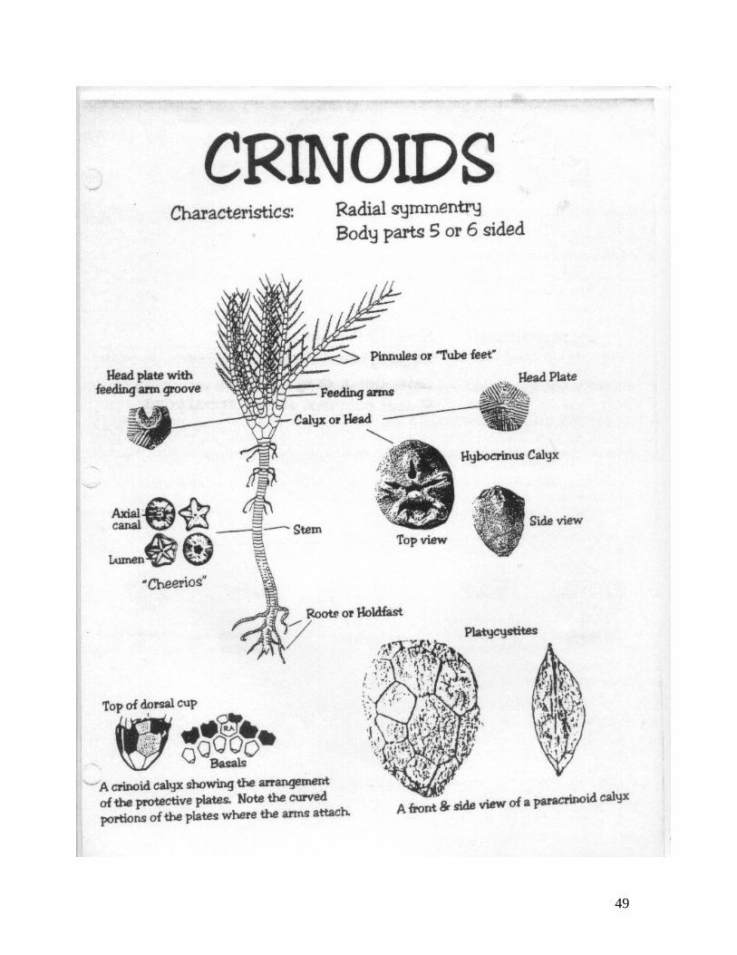
c. Have them thread three Cheerios, then an Apple Jack, repeating this pattern up the pipe cleaner. This is a yummy model of a Crinoid stem. **(DO NOT TELL THEM WHAT THEY HAVE BUILT YET!!! DON’T MENTION THE WORD CRINOID YET!)
d. Have students store these in baggies for later snacking.
16

6 Northwest End of Vesper Mountain
Folding & Striation of Rocks Human History
TEACHER BACKGROUND Patterns In Geology
1. Sedimentary rock comes from layers of particles turned to stone. 2. The position of rock layers helps us tell which is older. The layers, which lie
underneath, must be older. 3. Lime falls out of suspension, or precipitates as ocean water reaches a
certain depth. It falls to the ocean floor and accumulates. 4. Layers of sediment accumulate an eventually lithify by compaction and
cementation. Lime mud turns to limestone. Any organisms that do not fully decompose may be preserved as fossils.
5. The fossil record creates a pattern. Layers of rock tend to contain only certain fossils. For example we have never found a human fossil in the same rock layer as a dinosaur fossil. That is why we think humans never saw dinosaurs. Older rock layers contain the most extinct fossils, younger rock layers contain the most modern ones.
6. Layers of rock must start out flat (horizontal), but the rock layers here are tilted.
7. The pattern of the tilted rock layers resembles folding (or waves, or ripples) like pushing a carpet against a wall. This is especially easy to see in an aerial photograph, or in a large rock outcrop, or when the rocks are mapped in three dimensions.
8. Rock orientation tells us about the past. Ore tilt indicates more force. 9. It would require huge forces in nature to move bedrock.
Striation refers to the grooves and layers found in rocks; often appearing as
different colors due to the different minerals found in the various layers. A fault is a fracture in the Earth's crust along which motion may occur. It marks the boundary between two plates. There are three main types of faults:
17

A divergent fault occurs when two plates are moving away from each other.
When two plates come together, the result is a convergent fault. Often times, you will see a “tombstone” appearance of the rocks as a result of this type of movement. (Upcoming “Dragon’s Tail” between 7 & 8)
A fault that occurs when two plates slide past each other is known as a transform fault
Human History: Records indicate the earliest people here were Caddoan Indians and their
prehistoric ancestors. Evidence exists for people settling here before written records, as archeologists search for artifacts such as arrowheads. Projectile points and other tools have been dated to be as old as 8 thousand years. These people lived as hunters, farmers, and fishers. Occasional explorers crossed the area, and later trappers, but the area was barely seen by western civilization until the 1800s.
In 1837, southern Oklahoma was deeded by the US government to tribes of the Chickasaw to the west, and Choctaw to the east (both were originally located in Mississippi). In early American times, people did not see Oklahoma as a highly valuable area, since it was remote and had relatively poor soil (compared with
18

the Midwestern and Eastern United States). This was part of the reason that Indians were relocated to this area. When the Chickasaw Indians began to arrive from Mississippi and Alabama as frontier settlers in the 1850s, they found a land of forest, prairie, and water that was well suited for ranching and farming purposes. With the help of missionaries, they established fine schools and organized a government. The Chickasaws agreed to settle on the western lands, the Choctaw to the east. With hostile Indian neighbors to the west, the nomadic Kiowa and Comanche Indians relied heavily on a bison hunting economy. The Plains tribes considered the Chickasaw cattle a fair substitute for the bison that formerly grazed through the region, and hunted them.
The Americans established a series of forts in the area, mostly to protect the Indians who were busy establishing a farming and ranching economy, but also for defense. Fort Arbuckle (named for Colonel Matthew Arbuckle) was established by Captain Randolph B. Marcy 5 miles north of here in 1851. This would also seem to explain the naming of the Arbuckle Mountains. By 1860, the Chickasaw Indians were raising corn and cotton crops on Washita River valley plantations and running cattle herds throughout the entire Arbuckle Mountain range. At that time, the Arbuckle Mountains were capped with grasslands as far as the eye could see.
Just before American settlement came to “Indian Territory”, surveying of the land began 4 miles to the north. A famous land rush occurred in 1889, and Oklahoma became a state in 1907. The original initial point marker located one mile south of the Fort Arbuckle historical sign on Highway 7, is a four and one-half foot limestone shaft with the initials “IP” for Initial Point. This marks the exact intersection of the Indian Meridian that bisects Oklahoma north and south, and the Base Line that bisects east and west measurements of the state.
From the Chickasaw settlement period until the depression/dust bowl days of the 1930s, there were many families who strived to make their livelihood in the maze of valleys and hollows that are typical of the Arbuckle Mountain landscape. There was sure to be a homestead in every valley that contained a permanent spring. Anyone standing on the northwest end of Vesper Mountain in 1920 would have seen a purple and blue haze of smoke coming from the wood burning stoves of cabins hidden from view. The sound of ringing axes and mule teams could be heard as hard working farmers continued to clear and plow rocky fields. There are people living in nearby towns today who have vivid memories of these hill country sounds that included women calling milk cows in the evening, cow bells, roosters crowing, dogs barking and children playing on country lanes. Early settlers in this area include the Russell, Ham, and Rose families.
Dr. Collings of Norman, Oklahoma, owned a large ranch to the south of Vesper Mountain and it operated from 1928 to the 1960s. Dr. Collings named his ranch after the famous “101 Ranch”, located near Ponca City, Oklahoma. Dr. Collings’ ranch home was near Turner Falls. Camp Classen bought some of the ranch land in 1971.
The stream below, known as Lick Creek, originates as an artesian spring on private property several miles to the west. It meanders through Camp Classen, by eroding valleys in nonresistant rock formations and by widening weaknesses
19

in hard rock caused by faults. Lick Creek is fed by other springs that flow from the ravines and hollows all along its course. It is the main artery of Camp Classen.
In 1941, Lick Creek was dammed to make Lake Classen and in 1968, Lake Guy James (named in memory of a highly respected Oklahoma City community leader) was dammed. Lake Guy James acts as a reservoir for keeping the water level steady at Lake Classen. Look for the Guy James dam from this hill. There are many abandoned roadbeds on Camp Classen, including one that crossed the valley now flooded by Lake Guy James. Most are overgrown with trees and some that were used as ranch country access roads still have traces of asphalt. Count how many creeks must empty into Lake Guy James.
Student Activity
1. Rock Socks = Use 4 socks to demonstrate the moving/colliding/folding/breaking of layers at the fault lines. (Mention 3 types of faults and the results of each while modeling each of them with the socks.)
2. Discuss history from teacher background.
20

7 West Slope of Vesper Mountain
Biotic/Abiotic Factors-Ecotones
TEACHER BACKGROUND
A walk up or down the west side of Vesper Mountain on this switchback trail is like taking a short tour of the Great Plains. Look down into the valley. How do the plants change as one goes down in elevation? What else changes with elevation (Water, shade, soil, animal habitat)? As the abiotic things (bedrock, water, soil, exposure to the sun) change, the plants change, and thus animals change. Going higher in elevation is like traveling further toward the earth’s poles.
Two major biomes are represented at Camp Classen. A biome is a major ecologic community. The eastern deciduous forest biome is the largest remaining deciduous hardwood forest in the world. The Great Plains biome is the most diverse temperate grassland remaining on earth. Oak and hickory trees mark the forest. Several grasses, prickly pear cactus, yucca, and a variety of wildflowers mark the prairie. Take a look to find where both of these biomes are present. This blending of communities is called an ecotone. Eastern Red Cedar, or Juniper, grow in the rocky, sandy soils here. Look at the nearby hills. Notice how cedars are taking over the hillsides. Look for evidence of how people control the Cedars. Fire and grazing controlled their growth in the past. Now, with the great reduction of these activities, Classen controls the cedars in certain areas with saws and controlled burns. This area was burned in January 1995 and in March 1997. Burning yields fertilizer for pasture grasses. The trail on the west side of Vesper Mountain goes through a grassland habitat that has been partially restored by the removal of invading juniper trees. Since the tree cutting began in 1987, there has been a noticeable increase in the populations of prairie grasses and flowers.
Notice a pattern: Abiotic factors determine the biotic factors present in an area.
21
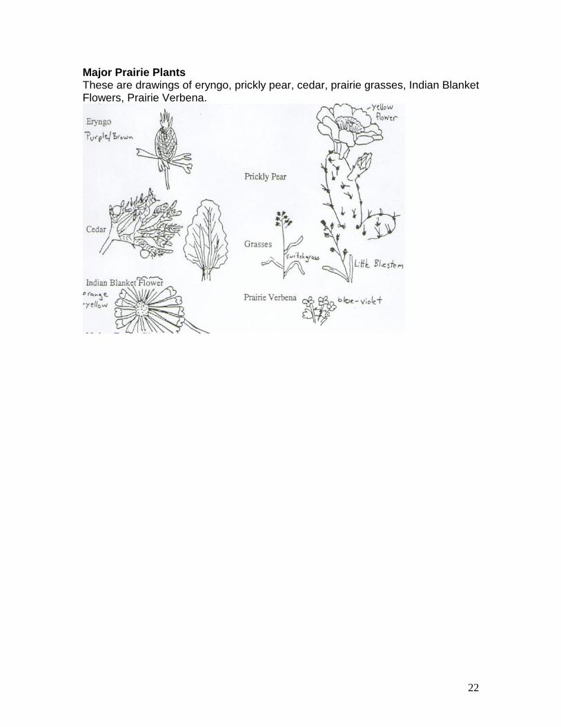
Major Prairie Plants These are drawings of eryngo, prickly pear, cedar, prairie grasses, Indian Blanket Flowers, Prairie Verbena.
22
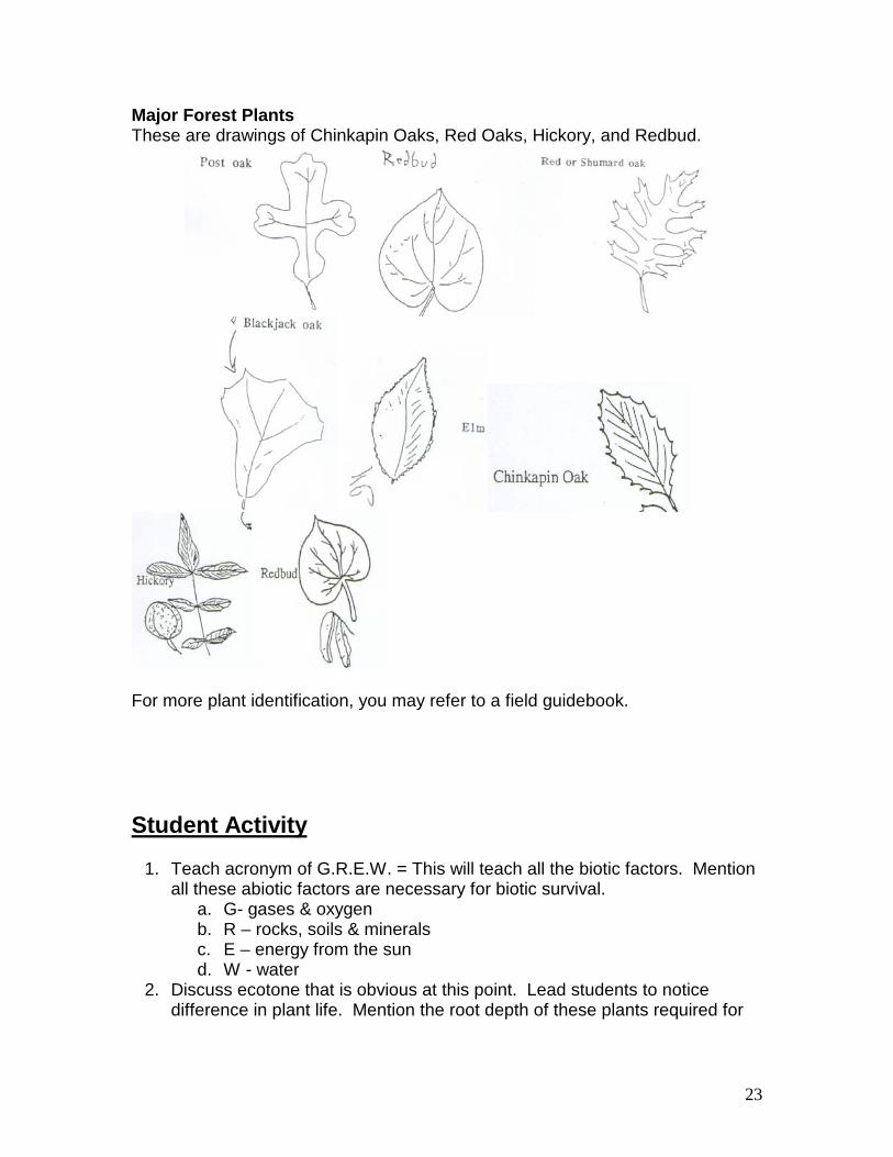
Major Forest Plants These are drawings of Chinkapin Oaks, Red Oaks, Hickory, and Redbud.
For more plant identification, you may refer to a field guidebook.
Student Activity
1. Teach acronym of G.R.E.W. = This will teach all the biotic factors. Mention all these abiotic factors are necessary for biotic survival.
a. G- gases & oxygen b. R – rocks, soils & minerals c. E – energy from the sun d. W - water
2. Discuss ecotone that is obvious at this point. Lead students to notice difference in plant life. Mention the root depth of these plants required for
23

survival and how soil depth determines type of plant life; therefore leading to specific type of animal life.
3. OH DEER ACTIVITY (This activity will need to be done a little further down the trail at a flat place. The Y is a good place.)
• Make two lines of students on the path facing each other. • Explain that one line of students will be resource and the other line
will be the deer. • Explain that the three resources we will be using are shelter(shown
by placing hands on top of head like a roof), water(shown by placing both hands over mouth) and food(shown by placing both hands on stomach).
• Tell students that each student (resources and deer) will turn facing opposite directions and choose which resource they are or if they are deer which resource they will need.
• Once all students are indicating which resource they are or need while facing away from each other have them turn and face each other.
• The deer are to step across and take a resource (student) that is the resource they require to survive.
• The deer that get their specific resources (shelter, food, water) stays alive and the resource that consumed joins them and become deer.
• The deer that do not get there needed meet become resources. The unclaimed resources stay resources.
It takes approximately 3 to 4 rounds to see the pattern of supply and demand and how it effects deer population.
24

8 White Rocks Near Lick Creek
Layers of the earth and there movement TEACHER BACKGROUND You may take the group to sit on the rocks near the miniature water falls (“flume”) to talk with them at this station. The rocks are a good example of the exposed tilted limestone so typical of the Arbuckles. The sum of Earth’s history is revealed and preserved in the rock record and can be read as the pages of a book. If one were to read Earth’s storybook chapter-by-chapter, it would become readily apparent that the Earth has undergone many changes over time and that these changes continue to occur. By looking closely at the rock record and the structures within the rocks themselves, we can learn about the conditions, which existed long ago. These white rocks and the view of Lick Creek are a good place to examine the evidence, to form the basis for our knowledge of the geologic past. The goal at this station is to draw together the natural evidence found so far on the Lick Creek Fossil Trail with the patterns in geology. We can decipher the geologic history of the area through this process.
Another important cycle in nature is the rock cycle. Geologists believe that all rock material on earth was originally hot magma. Sedimentary rock is made of particles (examples are sandstone, limestone, shale. Almost all the rock at Camp Classen is sedimentary). Igneous rock is any rock which came from molten rock, or magma, and later cooled and solidified (examples are granite, rhyolite, basalt). Metamorphic rock is any rock that has been altered by heat and/or pressure (examples are gneiss, shist, slate, marble).The process of weathering can break down any rock. The hardest minerals take the longest to break down. Of the major minerals in granite, amphibole is softest, feldspar medium, and quartz is hardest. Amphibole and feldspar eventually weather into clay.
The Major Rock Classifications a. Igneous rock resulted from the cooling of magma. b. Sedimentary rock results from:
1. the weathering of preexisting rock 2. the evaporation of sea water 3. the precipitation of organic substances from sea water
c. Metamorphic rock results from the transformation of preexisting rock under heat and pressure:
1. limestone changes to marble 2. shale changes to slate 3. sandstone changes to quartzite
25

Natural Evidence
1. This nearby stream (Lick Creek) flows over a flume here, carrying particles downstream.
2. You can see a layer of sediment filling up the gouge pool here. These sediments are particles of soil and debris from upstream. As the sediments fill the pool, we would expect the top of the sediment layer to be flat.
3. The white rocks are made of particles. If you examine the particles under a microscope, they look like microscopic ocean life (radiolaria, diatoms, cocoliths, etc.).
4. Chemicals in the stone are the same as those of ocean mud: Calcium Carbonate.
5. A few fossils have been found in this rock; relatives of squid (cephalopods), jellyfish and shellfish. What do you suppose the environment was like when this rock formed?
6. The layers in this rock are angled. 7. Several miles to the west, rock layers are angled, but they face the opposite
direction. 8. Other places at Camp Classen have outcrops of a rock which contains
smaller rocks (conglomerate) made of the same rock (Viola limestone) we are sitting on. Limestone is present across most of the edge of the continent of North America.
9. A mountain range exists roughly parallel to the east and southeast coast of North America.
Student Activity • Scratch a rock with your fingernail, another rock, or a metal key. Notice how
sediments come off. Different rocks have different hardness. Compare the hardness of several rocks.
• Rock hand signs • Sedimentary –
o Place one hand on top of the other; move bottom hand to the top (repeat again and again) saying the words “Sedimentary rock Layer” every time you move a hand.
• Metamorphic – (Heat and pressure) o Fan self-saying Heat. o Squish and twist cheeks with hands saying pressure.
• Ingenious – (Melting and Cooling) o Act like the Wicked Witch of the East from Oz saying I Melting in a
high-pitched voice. o Act like “The Fonz” (Happy Days) Thumbs up saying “Coooooooo”
• Earths layers activity: • Pass out Gobstoppers don’t let students eat yet. • Discuss layers of the earth using the cut in half teacher Gobstopper.
26

• Ask students which layer each candy layer represent (Coating=Curst, Hard candy=Mantel, Sweet tart=core
• Eat Candy – See earth layer diagram from appendix • Plate tectonics demonstration: Go to a flat open area where there is some
soft soil or grass. Have three students get on hands and knees, side by side. Another student lies on his back atop the backs of the students on their hands and knees. The three hands and knees students represent the Earth’s mantle, which is made of magma (molten rock beneath the surface). The student lying on top represents the earth’s crust. The hands and knees students move around and shake. Heat energy in the mantle may cause the crust to move. Watch for the legs of the lying down student to “buckle” or “fold.” This is the process that made the folding of the Appalachians and the Arbuckles.
• Sedimentation Bottle: • Teacher fill Sedimentation bottle (clear plastic) with H2O from creek. • Teacher Add one Shell • Students add more stuff (i.e. Sand, small pebbles, grass, dead
leaves, dirt etc.) make sure you add enough materials to make layers • Shake bottle up • Let settle and view at station 13
27

9 Confusion Canyon - Waterfall
The Power of Water TEACHER BACKGROUND
Notice the present day environment. The stream has worn away the rock. You can tell that this is no ordinary straight canyon, but it has a zigzag pattern. The water turns when it meets hard rock, and easily erodes soft rock. The green shale is on both sides of the wide part of the canyon just past the waterfall. This shale erodes quite easily. You can crumble it in your hand. It’s no accident that the waterfall formed here. The falls is a result of the shale having eroded away. The harder sandstone forced the stream to make a quick turn. When the stream found a crack, it turned again, into the crack. What do you suppose made the crack in the sandstone? Remember the major forces which uplifted these mountains in Pennsylvania time? It was a fault! Another crack in the rock allows the water to flow underground at another place in this canyon. See the accompanying diagram and note: Some rock layers erode slowly, and slow the water’s energy, and other rocks erode easily, leaving openings. These unusual, crazy patterns of stream behavior are the reason we call it Confusion Canyon. The creek has been in this place since the dam was built in 1968. The original stream was a little further to the north (straight ahead as you stand on shore looking across the canyon). A big flood in 1987 eroded literally tons of this rock and made this canyon much bigger than it was. Imagine the power of flowing water, after several days of hard rain. The stream carried entire trees, and the noise must have been deafening. Periodically, chunks of rock were loosened and carried away by the stream. When the powerful stream rolled over Classen Falls and hit Lake Classen, it lost much of its energy, and could no longer hold the sediments in suspension. So just beyond Classen Falls, it “dumped its load”, leaving fresh (recycled) sand on the creek bed, and new islands in Lake Classen. Student Activity
• Tell story • Have students look over the edge down into the canyon. Make sure that
every student is supervised while looking over. Please only let a few students look over the edge at a time.
28

10 Confusion Canyon – Down the Ladder
Weathering
TEACHER BACKGROUND Erosion: Water simply running across the rock physically carries away particles. The valleys and creek beds are the result of erosion. Speed of water greatly effects erosion rate. High energy (fast moving) water causes greater amounts of particle movement. Low energy (slower moving) water move causes less particle movement Weathering processes: A sort of “vicious cycle” occurs when soft rock becomes habitat to plants. As one weather process occurs, it makes way for others to occur. Several kinds of weathering occur: Chemical Weathering: Rainwater is slightly acidic. It always has been, even before the issue of acid rain. Lime is an alkali, which is the opposite of an acid. When the two meet, a chemical reaction occurs in which the rainwater dissolves the lime. Little pits in the rock are testimony to this process. Lichens: These pioneer plants are usually the first things to grow on exposed rock, they also grow on dead tree bark. Lichen is a symbiotic relationship of fungus and an algae. All three of the world’s major lichen groups, including the crustose (crusty), foliose (leafy), and fruticose (looks like fruit-bearing) categories are found at Camp Classen. Lichens growing on rocks have roots that break rock surface up as well as secrete weak acids that tend to erode limestone, leaving a pitted surface. 1. Freeze – Thaw: Frozen water is about 10 % larger in volume than liquid water. If liquid water should get trapped in a crack, and later refreeze, it will certainly expand, widening and breaking up the rock. 2. Root Pry: As plant and tree roots get established on a rock, the growth process of the roots helps widen existing cracks and breaks apart rocks. The roots trap soil, making a habitat for other plants. As various forms of weathering occur, sediments accumulate in the area. They will “pile up”, layer by layer, and one day become compacted. This lowland is truly a modern day depositional environment.
29

Ordovician Sands Underneath the soil and plants is bedrock. Clearly, there is a LOT of bedrock. In fact, it goes several miles down. How did these rocks get here? Sedimentary rocks begin as a mass of particles, which compact and turn to solid stone. The ocean mud at the fossil pit turned to limestone. Where does the yellow and orange rock look like it came from? (sand) Geologists agree it was probably a sandy beach, possibly the edge of the advancing ocean where the reef was located. Since it is made of mostly sand, we call it sandstone. It is not clear what causes the brown and orange bands in sandstone. More evidence that this was a beach can be found in the patterns on the tops of the sandstone rocks. These are worm action markings. The edge of an ocean is an excellent habitat for worms. Sand provides good shelter for worm burrows, and the waves deliver a steady supply of food. Further down the canyon, you may notice some dull green, flaky rock, called shale. Its depositional environment was a muddy swamp. The North American continent or craton has been the site of numerous transgressions and regressions over geologic time. Perhaps the greatest transgression began in the Late Cambrian Period and lasted for well over 100 million years. At its peak, marine waters had covered all but a small portion of the craton centered on Eastern Canada and the Great Lakes region. This shallow, warm ocean teemed with life. Locally, however, this drowning of the craton was interrupted for small periods of time. The Bromide Formation, as well as the rock formations above and below it, is the products of a series of these interruptions. Relative sea level in this area rose and fell repeatedly in the Middle Ordovician, roughly 400 million years ago. The Bromide Formation tells the story of an ancient sea advancing unto the edge of the craton and slowly moving in the northeast direction. At the beginning of this transgression, this area may have been covered by the sand dunes to a sandy beach fringing a shallow lagoon filled with sand bars. Relentlessly, the sea advanced further, cutting off the supply of mud and sand to the lagoon. Soon marine life invaded the newly created marine habitats. Colonies of bryozoans and brachiopods flourished and grew. A new group of animals, the echinoderms (examples of echinoderms include starfish, sand dollars, sea stars, and crinoids), also found this environment to its liking. These environments continued to shift landwards as the water continued to deepen. The muddy lagoon was replaced by a shallow, clear-water reef, which, in-turn, was replaced by a deeper water environment which produced a facies composed of thin limestone and shales. Then, the sea began to retreat. Swiftly, each of the environments shifted seawards. Although no sand or mud was available from the craton, the shallow lagoon was soon filled with lime mud and organic debris made by the plants and animals living there. A large beach covered with algal mats bordered this rapidly filling lagoon. In the end, the area was covered by a series of hard, shallow water limestones bleaching in the sun awaiting the next advance of the sea.
30

Student Activity
• Teacher takes small groups of students up the creek to the big rock to explain and point out types of Weathering and Erosion.
• Kodak moments
31

11 Before Bridge at Fossil Pit
Fossil Pit Preparation TEACHER BACKGROUND The rock here is called fossilferous limestone. It is fairly soft, and we will find a valley here. It is known as Bromide Limestone (named for the nearby town of Bromide), approximate age 470 million years. The fossilized animals we find here were all “filter feeders”, which means they ate microscopic plants (phytoplankton) and animals (zooplankton) which floated in the shallow ocean. Each species occupied its own niche in the reef ecosystem. The basis of the food web in this reef was algae. Algae require sunlight for photosynthesis, so the water must have been shallow enough for sunlight to penetrate and keep the algae (and the rest of the ecosystem) alive. You will want to know three main kinds of fossils: Bryozoans, brachiopods, and crinoids. Many of the fossils you will find in the Lick Creek fossil pit are brachiopods and bryozoans- two groups of animals that had flourished long before the Bromide Sea began to cover the North American continent. Roughly one-fourth of the fossils you will find belong to an entirely new group of animals- the echinoderms. The echinoderms are a diverse group of creatures that include starfish, crinoids, echinods, blastoids, cystoids, and paracrinoids, which all have pentameral, or five sided, symmetry to their bodies. These animals were very few in number, but they suddenly became extremely abundant in the Early and Middle Ordovician period (roughly 400 million years ago). This is particularly true of the crinoids, which became very numerous. Even more interestingly, the number of different types of crinoids increased by a factor of five in the same short (geologically speaking) period of time. This sudden increase in both the numbers and types of crinoids in the space of a few million years is an excellent example of the relationship between animals and their environment. The shallow, clear, warm water environmental niches had existed many times before in the past (prior to the Ordovician), but no animals were available to fill and exploit it effectively. The soccer-ball shaped bodies of the crinoids were equipped with long feeding arms firmly attached by a thick stem. The crinoid heads were covered in hard plates or rings, and were well designed to live in a shallow water environment, but poorly designed to live anywhere else. When this niche became available in the Early Ordovician, the crinoids swarmed into it. Suddenly, they became one of the most dominant species on Earth, multiplying rapidly as the shallow, warm water environment expanded. The crinoids also began to rapidly diversify in order to fill as many of the niches in this environment as efficiently as possible. The Lick Creek fossil pit is a snapshot of one phase of this explosion of the crinoids (and several related animals) into this newly created environment. The fossil pit contains a unique example of how changes in the environment can
32

radically alter the pattern of life in an area and how quickly animals adapt to these changes. The rock record of the fossil pit also preserves information about one of the most important types of ancient environment- the epeiric sea. Epeiric seas were shallow bodies of clear seawater that once covered portions of the continental landmasses. They were so shallow that they did not have tides, yet they were filled with millions of plants and animals of many different types. These plants and animals flourished in the clear, shallow waters which alternated between long periods of relative calm and short periods of furious wave activity whipped by wind and storms. A remote example of this type of environment is Florida Bay, surrounded by the Florida Keys. However, no close example of this type of environment exists today, even though it was a very common environment in the past and was home to a vast majority of all the life forms that have ever lived on Earth. The Lick Creek fossil pit provides a glimpse of the ever-changing nature of the Earth’s surface. It also provides a window for observing the rapid filling of a series of environmental niches by an explosive development of a new group of animals- the echinoderms. The view through this window can also serve to underline the delicate relationships between organisms and the fragility of any habitat when exposed to the raw power of nature. The Oklahoma Geological Survey and the Smithsonian Institute excavated this fossil pit in the 1960s. They uncovered some of the largest examples of crinoids ever found on Earth, some as big as one meter long. (Most crinoids are around a decimeter or so long.) These critters all lived strictly in saltwater habitat. There are mainly three kinds of fossils here: Bryozoans: The most common fossil here. Name means, “tree animals”, from their branchlike shape. These colonial animals lived at the bottom of the ocean. Each little dot is a “polyp”, or single organism. They are “filter feeders”, opening their little mouths to let in food. Crinoids: These animals are related to starfish, and you might see the five-sided pattern. They break easily after they die, so most often we find parts of them. Five feather-like objects trap food and send it to the calyx (head). Plates covered the calyx, which are common in the pit. The “cheerios” are broken stem parts. Crinoid body plan: (from top to bottom)
• Feeding arms made of rings (cheerios) • Soccer ball body also called the calyx, or head containing five-sided
plates • Stem of rings (cheerios) • Holdfast for anchoring to the reef
*The “cheerios” may be circular or horseshoe shaped.
33

Brachiopods: Name means “salt foot” or “arm foot”. These animals had “feet” made of soft tissue, which they used as an anchor to hold them in the ocean mud. You can identify these by finding lines on the shell, which radiate out from one edge of the heart-shaped shell. The shell material may give it a purple color. THINGS TO THINK ABOUT:
1. What was the most common type of fossil found? Why do you think there were more of these types of fossils?
Probably bryozoans; they were the toughest shelled of the creatures present and the best adapted to the environment. Brachiopods would be more numerous in the reef core and crinoid numbers are reduced by the intense fossil hunts of the mid-1960s.
2. What was the most common type of crinoid part found? What factors
would cause this part to be preserved more frequently than other parts of the crinoid?
Plates or stems; stems because there are large numbers of them and because they are tough and easy to preserve; plates because of the large numbers initially present
3. The type of bryozoans found can be used to tell us about water depth and
energy levels of the ancient seas. Tall and/or skinny bryozoans indicate deep, calm water or low energy environments while short and/or stubby bryozoans favored shallow water or high-energy environments. Using the percentages above, decide which type of marine environment existed when the fossil pit was being deposited. Does this agree with other evidence from the pit such as storm deposits, thin shale layers, and the presence of crinoids? Why or why not?
Remember that the pit accumulates over time so the fossils found represent an AVERAGE environment. Wide variations may exist at any one time due to storms or changes in water depth.
34

Student Activity Discussion:
• For a fossil to form, it must: 1. Have hard parts 2. Be buried quickly (such as in a storm) 3. Minerals must replace the living tissue
• Characteristics of the three common fossils found in the Lick Creek
fossil pit:
• Place Sedimentation bottle on Bridge (To allow settling)
• Fossil Pit Rules: 1. Each student may collect NO MORE of these fossils THAN CAN
FIT IN ONE HAND. Students may use a sandwich size bag for their fossils.
2. No digging tools are necessary, but a stick, shovel, or hammer may be helpful.
3. Usually the best fossils have been washed to the bottom of the pit, but students may climb in a safe manner to find another digging location.
4. Stay in sight of adult supervision at all times. 5. If you climb up, be careful not to kick rocks on anyone below you
• Hunt for fossils become a paleontologist 1. Pass out fossil finding equipments 2. Five fossils per person maximum, each fossil should be smaller
than your thumb nail!!!!!!!!!!!!!! (Note: if outstanding specimen is found please turn it into the Outdoor School Director)
3. Analyze the sedimentation bottle from station 8 4. Look for formation of layers 5. Look for the shell (could this end up a fossil?) 6. Empty out bottle, return to trail materials
35

12 Bridge before Activity Center
Conclusions and Review
Key concepts in this trail guide:
• All things come from the earth. We depend upon it for survival, and we have a great deal of impact on its care.
• We are members of a marvelous living community, interacting and
depending upon one another.
• Change occurs continually.
• Natural resources have affected human living throughout history. Soil, minerals, plants, and animals in an area affect our economic activities.
• Abiotic (nonliving) factors (climate, soil, water, etc.) determine plant life,
and plant life determines animal life (biotic factors - living).
• Geologists determine the history of an area through evidence in the rocks. Evidence may include minerals present, or the orientation of the rock layers.
• An aquatic ecosystem includes micro- and macro- biotic parts, which
interact in order to live.
• Many cycles are present in nature. One is the recycling of minerals as sediments, as they are eroded, deposited, and lithofied (turned to stone).
• A fossil reef is an ancient ecosystem, made of lime, turned to limestone.
Sand becomes sandstone, swamp mud becomes shale.
“Make it plain from the first that all living is relationship.”- Aldous Huxley
36

Appendix LICK CREEK FOSSIL PIT ANALYZING THE FOSSILS
Total number found: ________ Crinoids: _____ Bryozoans: _____ Brachiopods: _____ Crinoid Heads: _____ Crinoid plates: _____ Crinoid stems: _____ Tall/Skinny Bryozoans: _____ Short/Stubby Bryozoans: _____ PERCENTAGES:
1) Of the fossils, what percent were: Crinoids: _____ Bryozoans: _____ Brachiopods: _____
2) Of the crinoids, what percent were: Heads: _____ Plates: _____ Stems: _____
3) Of the bryozoans, what percent were: Tall/Skinny: _____ Short/Stubby: _____
37
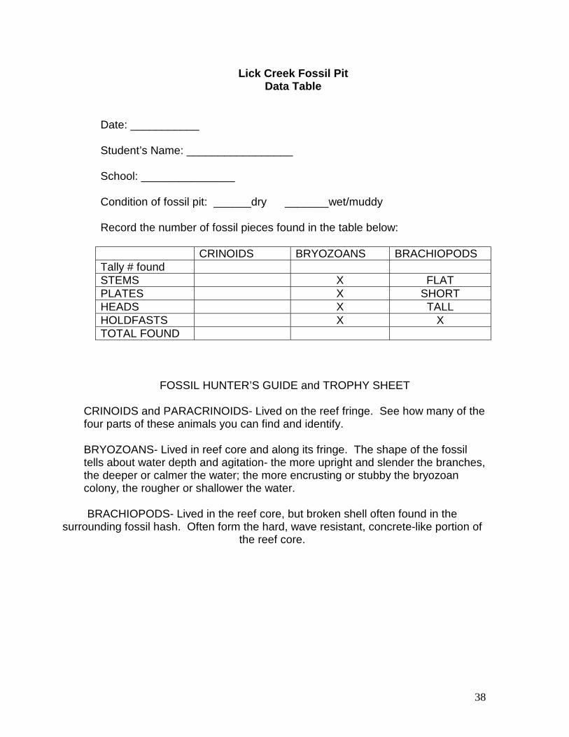
Lick Creek Fossil Pit Data Table
Date: ___________ Student’s Name: _________________ School: _______________ Condition of fossil pit: ______dry _______wet/muddy Record the number of fossil pieces found in the table below: CRINOIDS BRYOZOANS BRACHIOPODS Tally # found STEMS X FLAT PLATES X SHORT HEADS X TALL HOLDFASTS X X TOTAL FOUND
FOSSIL HUNTER’S GUIDE and TROPHY SHEET
CRINOIDS and PARACRINOIDS- Lived on the reef fringe. See how many of the four parts of these animals you can find and identify. BRYOZOANS- Lived in reef core and along its fringe. The shape of the fossil tells about water depth and agitation- the more upright and slender the branches, the deeper or calmer the water; the more encrusting or stubby the bryozoan colony, the rougher or shallower the water. BRACHIOPODS- Lived in the reef core, but broken shell often found in the
surrounding fossil hash. Often form the hard, wave resistant, concrete-like portion of the reef core.
38

Geological Time Scale (Detailed chart for background information)
Cenozoic Era – “Recent Life” Quaternary Period 0 to 2 million years ago man, early horses,
grasses, mammoths, sabre tooth cats
Holocene Epoch Pleistocene Epoch
0 to 10,000 years ago 10,000 to 2 million years ago
Tertiary Period 65 to 2 million years ago mammals, birds, forests, reptiles, marine organisms
Pliocene Epoch Miocene Epoch Oligocene Epoch Eocene Epoch Paleocene Epoch
12-2 million years ago 26-12 million years ago 38-26 million years ago 54-38 million years ago 65-54 million years ago
Mesozoic Era – “Middle Life” Cretaceous Period 135 to 65 million years ago flowering plants, dinosaurs Jurassic Period 180 to 135 million years
ago dinosaurs, birds, fishes
Triassic Period 225 to 180 million years ago
dinosaurs, amphibians, plants, trees, marine invertebrates
Paleozoic Era – “Ancient Life” Permian Period 270 to 225 million years
ago conifers, reptiles, marine animals
Pennsylvanian Period 320 to 270 million years ago
ferns, swamp plants, amphibians
Mississippian Period 350 to 320 million years ago
insects, swamp plants, sharks
Devonian Period 400 to 350 million years ago
land plants, fishes, true sharks
Silurian Period 440 to 400 million years ago
corals, trilobites, early plants
Ordovician Period 500 to 440 million years ago
seaweeds, fishes, shell fish, bryozoans, corals, gastropods, brachiopods, graptolites
Cambrian Period 570 to 500 million years ago
trilobites, protozoans,, worms,, sponges, jellyfish-like creatures
39

Precambrian Era – “Before Cambrian” (570 million years ago to the origin of earth) Proterozoic Eon 570 to 2500 million years ago Precambrian Z worms 570 to 800 million years
ago life accelerates appearance of soft body animals: sponges
Precambrian Y content increases
800 to 1600 million years ago
more complex forms of algae, atmosphere oxygen
2300 million years ago first ancient Ice Age covers N. America
Precambrian X 1600 to 2500 million years ago
Earth day is 18 hours long
Archean Eon (2500 million years to origin of earth) 3500 million years ago oldest dated microscopic life
fossils so far found 3780 million years ago oldest dated rocks so far found 4600 million years ago approximate age of earth
early earth was hot magma, its round shape due to gravity pulling the liquid and gas together
Activity: We will use people (or a rope) to walk a timeline. One foot (or step) represents 100 million years, 10 ft. = 1 billion years. Have students stand at various places along timeline.
40

Geologic Time Scale (Use this chart for teaching demonstration)
Yrs. ago Feet/steps Event 4.6 BY 46 Age of earth. planet is very hot rock, outer surface cooling
slowly; gravity makes it round 3.8 BY 38 Oldest dated rocks so far found; solid rock, early land, oceans
forming from condensing water vapor 3.5 BY 35 Oldest dated fossils of microscopic life so far found 2.8 BY 28 Earth spinning faster; earth day 18 hours long 2.3 BY 23 Earliest dated Ice Age over North America (many more later) 1.5 BY 15 Oxygen increases in atmosphere probably due to
photosynthetic algae 1.4 BY 14 More complex forms of algae 1.0 BY 10 Soft bodied animals: worms, sponges 570 MY 5.7 “Cambrian explosion” of life: trilobites, simple crustaceans,
more sponges 500 MY 5 Ordovician time. Most Classen rocks (including fossil pit) are
from this time. Seaweeds, fishes, brachiopods, bryozoans, graptolites
440 MY 4.4 Silurian time. Corals, trilobites, early plants. Continents taking shape
400 MY 4 Devonian time. Corals, land plants and trees, true sharks, more fish
350 MY 3.5 Mississippian time. Insects, swamp plants 320 MY 3.2 Pennsylvanian time. Ferns, swamp plants, 270 MY 2.7 Permian time. Coniferous trees, reptiles, marine animals 225 MY 2.25 Triassic time. Dinosaurs, amphibians 180 MY 1.8 Jurassic time. Dinosaurs, birds, fishes 135 MY 1.35 Cretaceous time. Dinosaurs, early mammals, flowering plants 65 MY .065 or 7” Tertiary time. No dinosaurs, mammals, birds, forests, flowering
plants 0-2 MY .002 or .3” Quaternary time. Humans, recent ice ages, mammoths, early
horses, giant beavers, sabre tooth tigers, grasses
Question: From this information, did early humans ever see dinosaurs? (no- 60 MY between them.)
41

Stratigraphic Column For The Camp Classen Area (Youngest on top, oldest below)
(This chart is simplified.) *Indicates rock is visible on the Lick Creek Trail. Other rock can be found at Camp Classen or
nearby.
Time Rock Name Characteristics Depositional Environment
0-2 Million Quaternary
*Alluvial soils Deposited by streams Same as modern
approx. 270 Million Late Pennsylvanian
Collings Ranch Conglomerate
Limestone and sandstone cobbles in a
sandy mix
High energy erosion and
deposition of the rising Arbuckle
Mountains approx. 350 Million
Late Devonian Woodford Shale Dark fissile shale and
chert, fossils (trees and spores)
Forest and swamp
approx. 460 Million
Mid Orovician *Bromide Limestone
and shale Fossilferous (crinoids,
bryozoans, brachiopods) limestone
and well rounded sandstone
Shallow, high energy reef,
changing depth
approx. 460 Million Mid Orovician
Tulip Creek Limestone and
Sandstone
Fossilferous limestone and sandstone
encroaching ocean
approx. 460 Million Mid Orovician
McLish Limestone and Sandstone
Limestone with many algal mats
encroaching ocean
approx. 460 Million Mid Orovician
Oil Creek Limestone and Sandstone
Fossilferous limestone and sandstone
encroaching ocean
approx. 470 Million Mid Ordovician
*Viola Limestone Clean, white, hard limestone, deep to semi-deep ocean fossils (trilobites,
graptolites, cephalopods)
Medium deep ocean, changing
depths
approx. 480 Million Late Ordovician
Sylvan Shale Dark, greenish-gray shale, few fossils
Deep ocean, changing depth
approx. 500 Million Late Cambrian
Reagan Sandstone Sandstone rich in feldspar and worm scat
fossils
beach
approx. 525 Million Mid Cambrian
Colbert Rhyolite Dark colored quartz, feldspar, iron
flowing volcano lava
approx. 1,350 Million
Precambrian
Tishomingo Granite Pink, black, and gray granite
Magma cooling slowly under the earth’s surface
42

Geological Time Scale Activity (Use this information for teaching demonstration)
Geological Timeline
• 46 feet = Estimated Age of Earth 4600 Million years • 39 feet = Earliest form of single celled life 3900 Million years • 38 feet = Oldest dated rocks 3800 Million years • 23 feet = N. America/Europe covered in Ice Age 2300 Million years • 15 feet = Oxygen builds up in the atmosphere 1500 Million years • 4 feet = Continents take shape 400 Million years • 2.25 ft = Age of Dinosaurs 225 Million years • 6.5 inches = End of Age of Dinosaurs 65 Million years
2 inches = Human Life 200,000 years
43

44

45

46

47

48
49

50

51