Calvert Hall 2007 West Sulawesi
16
Cenozoic evolution of the Lariang and Karama regions, North Makassar Basin, western Sulawesi, Indonesia Stephen J. Calvert 1,2 and Robert Hall 1 1 SE Asia Research Group, Department of Geology, Royal Holloway University of London, Egham, Surrey TW20 0EX, UK 2 Marathon Oil Company, Beltway Office Park, Building A, 4th Floor, Jalan TB Simatupang No. 41, Jakarta 12550, Indonesia (e-mail: [email protected]) ABSTRACT: The Lariang and Karama regions of western Sulawesi, an area of approximately 10 000 km 2 , were the subject of a field-based investigation with the aim of understanding the Cenozoic evolution of the North Makassar Basin. Western Sulawesi was influenced by the development of the Makassar Straits to the west and the collision of continental, ophiolitic and island-arc fragments to the east. The timing of these events has been the subject of considerable debate and it has been suggested that Neogene collisions in Sulawesi caused inversion in Borneo. A new stratigraphy for the Lariang and Karama regions of western Sulawesi, based on fieldwork, provides new and significant insights into the evolution of the Makassar Straits region. The oldest sediments are non-marine and could be as old as Paleocene; they include coals, sandstones and mudstones. Rifting had started by the Middle Eocene and continued into the Late Eocene. Syn-rift Eocene sediments were deposited in graben and half-graben in both marine and marginal marine environ- ments. The Eocene Makassar Straits rift was highly asymmetrical; the Kalimantan margin was approximately twice the width of the Sulawesi margin. Thermal subsidence had started by the latest Eocene and by the end of the Oligocene most of western Sulawesi was an area of post-rift shelf carbonate and mudstone deposition. This shallow-marine depositional environment persisted throughout the Early Miocene and, in places, until the Middle or Late Miocene. In the Pliocene the character of sedimentation changed significantly. Uplift and erosion was followed by the deposition of coarse clastics derived from an orogenic belt to the east of the study area. The Palaeogene half-graben were inverted, there was localized detach- ment folding and the overlying Neogene section was folded, faulted and eroded in places. Contractional deformation in western Sulawesi dates from the Pliocene, whereas in eastern Kalimantan it dates from the Early Miocene. KEYWORDS: Makassar Straits, Sulawesi, Lariang, Karama, rifting INTRODUCTION The onshore portion of the Lariang and Karama basins covers an area of approximately 10 000 km 2 of the coastal lowlands of western Sulawesi (Fig. 1). Based on the integration of field, biostratigraphic and remote sensing data, a new stratigraphy has been produced for the region (Fig. 2; Calvert 2000) and is a significant revision of previous work (Sukamto 1973; Hadiwijoyo et al. 1993; Ratman & Atmawinata 1993). In recent years a number of geological models have been proposed for the evolution of the Makassar Straits, which reflect insights derived from studies of eastern Kalimantan and eastern Sulawesi (Ali et al. 1996; Simandjuntak & Barber 1996; Parkinson 1998; Walpersdorf et al. 1998; Guntoro 1999; Charlton 2000; McClay et al. 2000) but lack information from western Sulawesi. Models that include the western Sulawesi region (Fig. 1) have assumed that it was affected firstly by Palaeogene extension (e.g. Hamilton 1979) which eventually led to the formation of the Makassar Straits and, secondly, by Neogene contraction and uplift driven principally from the east (e.g. Bergman et al. 1996). The Sulawesi Neogene contraction has been widely interpreted as the explanation of inversion at the conjugate margin in East Kalimantan (Letouzey et al. 1990; Daly et al. 1991; Bransden & Matthews 1992; van de Weerd & Armin 1992; Tanean et al. 1996; Cloke et al. 1997; Longley 1997; McClay et al. 2000). Therefore, the study area is in an ideal location to observe the effects of Palaeogene extension and is adjacent to the Neogene orogenic belt of Sulawesi. This investigation of the geology of the region was carried out to help constrain the timing of Cenozoic tectonic events. Onshore oil seeps and potential offshore gas hydrates in the North Makassar Basin show that a working petroleum system exists in this frontier region which is opposite one of the largest hydrocarbon provinces in SE Asia (Calvert & Terry 2001; Jackson 2004). A post-war report by BPM (Bataafsche Petro- leum Maatschappij, the principal Dutch-Shell company in Indonesia) considered the region to be the second most prospective in Sulawesi after Buton. Petroleum Geoscience, Vol. 13 2007, pp. 353–368 1354-0793/07/$15.00 2007 EAGE/Geological Society of London
-
Upload
tommynaibaho -
Category
Documents
-
view
42 -
download
3
Transcript of Calvert Hall 2007 West Sulawesi
Cenozoic evolution of the Lariang and Karama regions, North MakassarBasin, western Sulawesi, Indonesia
Stephen J. Calvert1,2 and Robert Hall11SE Asia Research Group, Department of Geology, Royal Holloway University of London, Egham, Surrey TW20 0EX, UK
2Marathon Oil Company, Beltway Office Park, Building A, 4th Floor, Jalan TB Simatupang No. 41, Jakarta 12550,Indonesia (e-mail: [email protected])
ABSTRACT: The Lariang and Karama regions of western Sulawesi, an area ofapproximately 10 000 km2, were the subject of a field-based investigation with theaim of understanding the Cenozoic evolution of the North Makassar Basin. WesternSulawesi was influenced by the development of the Makassar Straits to the west andthe collision of continental, ophiolitic and island-arc fragments to the east. Thetiming of these events has been the subject of considerable debate and it has beensuggested that Neogene collisions in Sulawesi caused inversion in Borneo. A newstratigraphy for the Lariang and Karama regions of western Sulawesi, based onfieldwork, provides new and significant insights into the evolution of the MakassarStraits region. The oldest sediments are non-marine and could be as old asPaleocene; they include coals, sandstones and mudstones. Rifting had started by theMiddle Eocene and continued into the Late Eocene. Syn-rift Eocene sediments weredeposited in graben and half-graben in both marine and marginal marine environ-ments. The Eocene Makassar Straits rift was highly asymmetrical; the Kalimantanmargin was approximately twice the width of the Sulawesi margin. Thermalsubsidence had started by the latest Eocene and by the end of the Oligocene mostof western Sulawesi was an area of post-rift shelf carbonate and mudstonedeposition. This shallow-marine depositional environment persisted throughout theEarly Miocene and, in places, until the Middle or Late Miocene. In the Pliocene thecharacter of sedimentation changed significantly. Uplift and erosion was followed bythe deposition of coarse clastics derived from an orogenic belt to the east of thestudy area. The Palaeogene half-graben were inverted, there was localized detach-ment folding and the overlying Neogene section was folded, faulted and eroded inplaces. Contractional deformation in western Sulawesi dates from the Pliocene,whereas in eastern Kalimantan it dates from the Early Miocene.
KEYWORDS: Makassar Straits, Sulawesi, Lariang, Karama, rifting
INTRODUCTION
The onshore portion of the Lariang and Karama basins coversan area of approximately 10 000 km2 of the coastal lowlandsof western Sulawesi (Fig. 1). Based on the integration of field,biostratigraphic and remote sensing data, a new stratigraphyhas been produced for the region (Fig. 2; Calvert 2000) andis a significant revision of previous work (Sukamto 1973;Hadiwijoyo et al. 1993; Ratman & Atmawinata 1993).
In recent years a number of geological models have beenproposed for the evolution of the Makassar Straits, whichreflect insights derived from studies of eastern Kalimantanand eastern Sulawesi (Ali et al. 1996; Simandjuntak & Barber1996; Parkinson 1998; Walpersdorf et al. 1998; Guntoro 1999;Charlton 2000; McClay et al. 2000) but lack information fromwestern Sulawesi. Models that include the western Sulawesiregion (Fig. 1) have assumed that it was affected firstly byPalaeogene extension (e.g. Hamilton 1979) which eventually ledto the formation of the Makassar Straits and, secondly, by
Neogene contraction and uplift driven principally from the east(e.g. Bergman et al. 1996). The Sulawesi Neogene contractionhas been widely interpreted as the explanation of inversion atthe conjugate margin in East Kalimantan (Letouzey et al. 1990;Daly et al. 1991; Bransden & Matthews 1992; van de Weerd &Armin 1992; Tanean et al. 1996; Cloke et al. 1997; Longley 1997;McClay et al. 2000). Therefore, the study area is in an ideallocation to observe the effects of Palaeogene extension and isadjacent to the Neogene orogenic belt of Sulawesi. Thisinvestigation of the geology of the region was carried out tohelp constrain the timing of Cenozoic tectonic events. Onshoreoil seeps and potential offshore gas hydrates in the NorthMakassar Basin show that a working petroleum system exists inthis frontier region which is opposite one of the largesthydrocarbon provinces in SE Asia (Calvert & Terry 2001;Jackson 2004). A post-war report by BPM (Bataafsche Petro-leum Maatschappij, the principal Dutch-Shell company inIndonesia) considered the region to be the second mostprospective in Sulawesi after Buton.
Petroleum Geoscience, Vol. 13 2007, pp. 353–368 1354-0793/07/$15.00 � 2007 EAGE/Geological Society of London
This paper presents an integrated summary of the geology ofthe Lariang and Karama regions. The new stratigraphy isdescribed with details of the Palaeogene rift sequences. Newgeological mapping (Fig. 3), combined with interpretation ofvintage onshore seismic data, has enabled a structural inter-pretation of the region. Detailed sedimentary facies analyses,combined with information from microfossil assemblages, haveallowed interpretation of Cenozoic environments. The signifi-cant regional events that preceded the Eocene formation of riftbasins are discussed and the basement structures throughoutthe Makassar Straits region are compared. The final sectiondeals with the early Cenozoic basin style and sedimentary basinfill throughout the Makassar Straits region and comparisons aremade with other rifted basins.
STRATIGRAPHY
No single study has focused previously on the entire Lariangand Karama region. The region was first mentioned in geo-logical reviews of the Dutch East Indies (Hundling 1942;Beltz 1944) and summarized with other Dutch work by vanBemmelen (1949). The region was also mentioned briefly byHamilton (1979) and Kartaadiputra et al. (1982), but it wasGRDC (Geological Research and Development Centre,Indonesia, now the GSC, Geological Survey Centre) who werethe first to publish geological reports on different parts of the
study area. The study area covers three 1: 250 000 quadranglesmapped by GRDC, each with its own stratigraphy (Sukamto1973; Hadiwijoyo et al. 1993; Ratman & Atmawinata 1993). Thenew stratigraphy presented here (Fig. 2) is based on fieldworkcarried out in 1996 and 1997 as part of a PhD at the Universityof London (Calvert 2000) and additional work in 2001 (Calvert& Terry 2001).
Mesozoic pre-rift basement
The Mesozoic basement in the Lariang and Karama regions(Fig. 3) consists of metamorphic rocks unconformably overlainby less deformed Upper Cretaceous dark shales and volcanicrocks. This basement crops out mainly in the highlands wherethere are peaks up to 3000 m high. Various names and ages(Table 1) have been given to the metamorphic rocks of westernSulawesi (Hadiwijoyo et al. 1993; Ratman & Atmawinata 1993).The overlying dark shales and volcanics are at least 1000 mthick and are considered laterally equivalent to basement inother parts of western Sulawesi (Table 2). These rocks havebeen interpreted to be the deposits of a forearc basin situated tothe west of a west-dipping subduction zone (van Leeuwen1981; Hasan 1991).
Volcanic rocks
The terms Kambuno, Lamasi and Talaya Volcanic Units(Norvick & Pile 1976; Hadiwijoyo et al. 1993; Ratman &Atmawinata 1993) are not part of the stratigraphic scheme usedhere. The volcanic rocks have not been dated and, overall, littleis known about them. Norvick & Pile (1976) assumed thesepredominantly basaltic to andesitic rocks to be, in part, laterallyequivalent to their Budungbudung Formation. Probable Palaeo-gene basalts form part of the basement complex in theLatimojong Complex (Coffield et al. 1993) and a Cretaceous toPalaeogene Lamasi Complex was reported by Bergman et al.(1992). Volcanic rocks mapped by Hadiwijoyo et al. (1993) areunconformable on the Latimojong Formation. Volcanic rocksin the core of an anticline in the Karama River, which weremapped as the Miocene Talaya volcanic rocks by Ratman &Atmawinata (1993), are regarded here as being older thanMiddle Eocene. In all cases exposures previously assigned tothese volcanic units and visited in this study are always closelyassociated with the Upper Cretaceous rocks, are always overlainby the Toraja Group and are older than Middle Eocene and,hence, mapped as such. The volcanic rock units could be eitherof Cretaceous age and related to accretion, or Cenozoic andrelated to early Palaeogene rifting. Volcanic rocks in the SouthArm of Sulawesi and SE Kalimantan have been related tosubduction along the southern margin of Sundaland during theLate Cretaceous (Hasan 1991; Moss et al. 1997; Parkinson et al.1998; Soeria-Atmadja et al. 1998). In Kalimantan some vol-canic rocks have been related to Early Cenozoic extensionaltectonics (Hutchison 1996; Moss & Chambers 1999). How-ever, the age and nature of these Late Cretaceous or earlyCenozoic igneous rocks are poorly understood, they are notwell dated, are poorly described and their chemistry couldreflect older Mesozoic subduction.
Palaeogene syn-rift to post-rift Toraja Group
The Middle Eocene to lower Upper Oligocene Toraja Group(new name; Fig. 2) is exposed between the northern QuarlesMountains and the northeastern Molengraaff Mountains (Fig.3). The Toraja Formation of Ratman & Atmawinata (1993) hasbeen elevated here to group status. This change has been made
Fig. 1. Simplified geological map of Sulawesi after Hall & Wilson(2000) with box showing the location of the Lariang and Karamaregions. Tectonic provinces and names of the different areas ofSulawesi referred to in the text are shown.
S. J. Calvert & R. Hall354
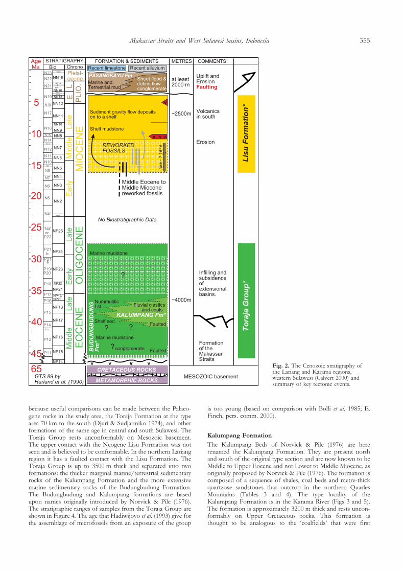
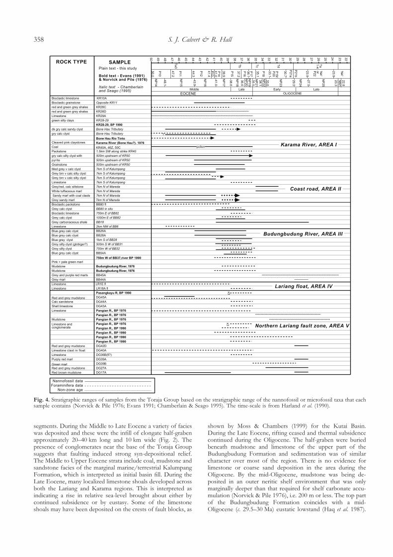
because useful comparisons can be made between the Palaeo-gene rocks in the study area, the Toraja Formation at the typearea 70 km to the south (Djuri & Sudjatmiko 1974), and otherformations of the same age in central and south Sulawesi. TheToraja Group rests unconformably on Mesozoic basement.The upper contact with the Neogene Lisu Formation was notseen and is believed to be conformable. In the northern Lariangregion it has a faulted contact with the Lisu Formation. TheToraja Group is up to 3500 m thick and separated into twoformations: the thicker marginal marine/terrestrial sedimentaryrocks of the Kalumpang Formation and the more extensivemarine sedimentary rocks of the Budungbudung Formation.The Budungbudung and Kalumpang formations are basedupon names originally introduced by Norvick & Pile (1976).The stratigraphic ranges of samples from the Toraja Group areshown in Figure 4. The age that Hadiwijoyo et al. (1993) give forthe assemblage of microfossils from an exposure of the group
is too young (based on comparison with Bolli et al. 1985; E.Finch, pers. comm. 2000).
Kalumpang Formation
The Kalumpang Beds of Norvick & Pile (1976) are hererenamed the Kalumpang Formation. They are present northand south of the original type section and are now known to beMiddle to Upper Eocene and not Lower to Middle Miocene, asoriginally proposed by Norvick & Pile (1976). The formation iscomposed of a sequence of shales, coal beds and metre-thickquartzose sandstones that outcrop in the northern QuarlesMountains (Tables 3 and 4). The type locality of theKalumpang Formation is in the Karama River (Figs 3 and 5).The formation is approximately 3200 m thick and rests uncon-formably on Upper Cretaceous rocks. This formation isthought to be analogous to the ‘coalfields’ that were first
Fig. 2. The Cenozoic stratigraphy ofthe Lariang and Karama regions,western Sulawesi (Calvert 2000) andsummary of key tectonic events.
Makassar Straits and West Sulawesi basins, Indonesia 355

described in this region by Reyzer (1920). The formation passeslaterally into and is conformably overlain by limestone of theBudungbudung Formation.
Budungbudung Formation
The type area for the Budungbudung Formation is near theBudungbudung River in the northern Karama region (Fig. 3)and the formation has an estimated minimum thickness of1000–2000 m. Although the type section of the Budungbudung
Formation of Norvick & Pile (1976) was not visited in thisstudy, rocks close to it and at other localities where it is mappedwere studied in detail. These rocks closely resemble thosedescribed by Norvick & Pile (1976) and, therefore, the namehas been retained. The Middle Eocene to Upper OligoceneBudungbudung Formation of this study is a variable sequenceof variegated soft to shaly mudstones, quartzose sandstones,limestones and minor conglomerates (Tables 3 and 4). Theformation is exposed in the Karama region and the northernLariang region, where the formation is unconformable on
Fig. 3. Geological map of the Lariangand Karama regions, western Sulawesi(Calvert 2000).
S. J. Calvert & R. Hall356

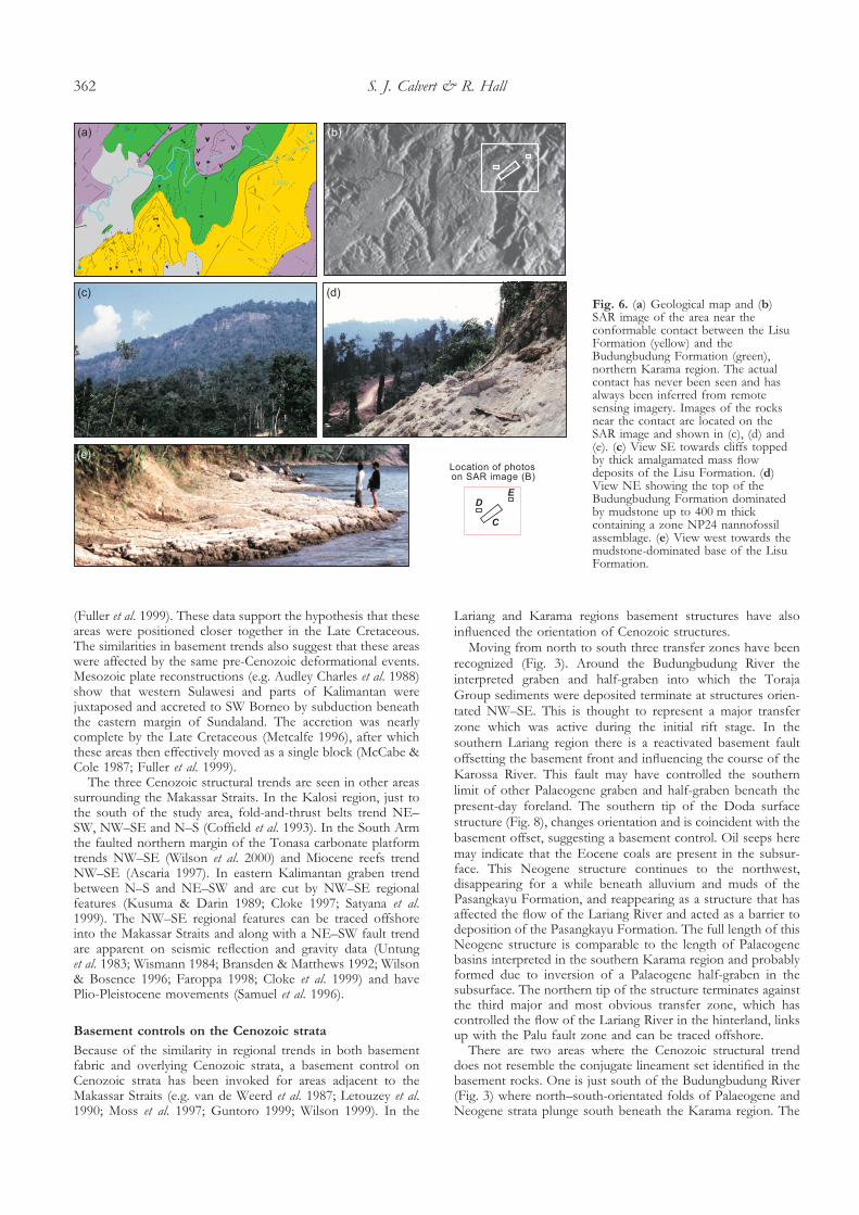
Upper Cretaceous rocks. The upper contact with the overlyingLisu Formation (Fig. 6) was crossed in both regions but wasnot seen. In the Karama River the formation passes laterallyinto and overlies the Middle to Upper Eocene KalumpangFormation.
Interpretation of the Toraja Group
The Toraja Group records subsidence in the Lariang andKarama region (Fig. 7) from the Middle Eocene through to the
early Late Oligocene (NP15–NP24). There is no firm evidencefor Paleocene to Lower Eocene strata in the study area. In theKarama region Palaeogene half-graben have been interpretedfrom seismic lines (Calvert & Hall 2003) and from surface data.The Kalumpang Formation and lower parts of the Budungbu-dung Formation were deposited in NE–SW-trending half-graben formed in a period of extension during the Middle andLate Eocene (Fig. 7a). Mapping shows that the Toraja Groupterminates at regions orientated NW–SE (Fig. 3), which mayhave been transfer zones between individual half-graben
Table 1. Summary of the various names, ages and equivalent names used by different authors to describe the Mesozoic metamorphic rocks of western Sulawesi
Area Name Age Author Equivalent Author
Mamuju Quadrangle Metamorphic Rocks Pre-Cretaceous, possiblyTriassic
Ratman &Atmawinata 1993
Wana Complex Hadiwijoyo et al. 1993
Glaucophane Schist ofthe PompangeoComplex
Simandjuntak et al.1991a
PasangkayuQuadrangle
Wana Complex Triassic Hadiwijoyo et al. 1993 Lariang River CrystalineSchist Group
OTCA 1971
Gneiss and schist Sukamto 1975Gumbasa Complex Triassic–Jurassic Hadiwijoyo et al. 1993 Sopu River Gneiss Gp. OTCA 1971
Palopo Formation Sudrajat 1981Gneiss and schist Sukamto 1975
Palu valley and neckof Sulawesi
Toboli Complex Early Mesozoic or evenPalaeozoic
Sopaheluwakan et al.1995
None given
Garnet peridotite Emplacement to surfacein the Neogene
EclogitesCentral Sulawesi Maliliand Poso Quadrangles
Pompangeo Complex E. Cretaceous schist, c.111 Ma
Parkinson 1991, 1998 Latimojong Complex Simandjuntak et al.1991a, b; Parkinson1998
South Arm Bantimala Complex Jurassic sandstone. E.Cretaceous schist113–132 Ma
Wakita et al. 1996 Pompangeo Schists Wakita et al. 1996
Barru Complex E. Cretaceous,106 Ma Wakita et al. 1996 Similar to Bantimala Wakita et al. 1996Schist in theLatimojong Mountains
114 Ma, 123 Ma,128 Ma
Bergman et al. 1996 Similar to Pompangeoschist ages
Parkinson 1998
Table 2. Summary of the names, ages and equivalent names used by different authors to describe the Cretaceous rocks of western Sulawesi
Area Name Age Author Equivalent Author
Karama region Cretaceoussedimentary rocks
Late Cretaceous lateCampanian to earlyMaastrichtian
Chamberlain & Seago(1995)
Mamuju andPasangkayuQuadrangles
Latimojong Formation Late Cretaceous Ratman &Atmawinata 1993;Hadiwijoyo et al. 1993
Latimojong Fm. in theMalili and PosoQuadrangles
Ratman &Atmawinata 1993;Hadiwijoyo et al. 1993
Kalosi Region Latimojong Complexreferred to Mesozoicas Mesozoic basement
Mesozoic Coffield et al. 1993 Tinombo FormationLatimojong Mountainsand similar to theBalangbaru and MaradaFormations
Hadiwijoyo et al. 1993;Parkinson et al. 1998;Coffield et al. 1993
South Arm Balangbaru Formation Late Cretaceous n.o.tearly Turonian and n.y.tlate Maastrichtian (about90–65 Ma)
Hasan 1992
Early to MiddleCretaceous
Wakita et al. 1996 Considered as part ofthe Bantimala Complex
Wakita et al. 1996
Marada Formation Late Cretaceous lateCampanian to earlyMaastrichtian
van Leeuwen 1981 Balangbaru Formation Hasan 1990
This study Cretaceous rocks Late Cretaceous, lateCampanian to earlyMaastrichtian
This study Marada Formation This study
n.o.t, not older than; n.y.t, not younger than
Makassar Straits and West Sulawesi basins, Indonesia 357
segments. During the Middle to Late Eocene a variety of facieswas deposited and these were the infill of elongate half-grabenapproximately 20–40 km long and 10 km wide (Fig. 2). Thepresence of conglomerates near the base of the Toraja Groupsuggests that faulting induced strong syn-depositional relief.The Middle to Upper Eocene strata include coal, mudstone andsandstone facies of the marginal marine/terrestrial KalumpangFormation, which is interpreted as initial basin fill. During theLate Eocene, many localized limestone shoals developed acrossboth the Lariang and Karama regions. This is interpreted asindicating a rise in relative sea-level brought about either bycontinued subsidence or by eustasy. Some of the limestoneshoals may have been deposited on the crests of fault blocks, as
shown by Moss & Chambers (1999) for the Kutai Basin.During the Late Eocene, rifting ceased and thermal subsidencecontinued during the Oligocene. The half-graben were buriedbeneath mudstone and limestone of the upper part of theBudungbudung Formation and sedimentation was of similarcharacter over most of the region. There is no evidence forlimestone or coarse sand deposition in the area during theOligocene. By the mid-Oligocene, mudstone was being de-posited in an outer neritic shelf environment that was onlymarginally deeper than that required for shelf carbonate accu-mulation (Norvick & Pile 1976), i.e. 200 m or less. The top partof the Budungbudung Formation coincides with a mid-Oligocene (c. 29.5–30 Ma) eustatic lowstand (Haq et al. 1987).
Fig. 4. Stratigraphic ranges of samples from the Toraja Group based on the stratigraphic range of the nannofossil or microfossil taxa that eachsample contains (Norvick & Pile 1976; Evans 1991; Chamberlain & Seago 1995). The time-scale is from Harland et al. (1990).
S. J. Calvert & R. Hall358

The relative sea-level fall shown by Haq et al. (1987) is about200 m, which is greater than the water depth estimated for theLariang and Karama regions at this time. This sea-level fall
should therefore have exposed these regions and caused aninput of coarse clastics, for which there is no evidence. Thissuggests that the sea-level fall was less than that predicted by
Table 3. Lithofacies of the Toraja Group
Facies code Lithofacies Sedimentary structures Interpretation Exposed in areas
Mudstone
FH Homogeneous mudstone (claystonesiltstone, marlstone), 10–4000 cmthick
Tops and bases non-gradational,massive with detrital organic materialin places
Suspension fallout possibly rapid andreworking by organisms
III, one sample;V, two samples
FI Interbedded mudstone (claystone,siltstone and marlstone), 20–2100 cmthick
Massive and structureless Alternating suspension fallout, rapiddeposition
I, one sample
FL Laminated mudstone, 12–400 cm Centimetre and millimetrelaminations
Fluctuating organic input duringsuspension fallout or fluctuating currentvelocities or boundary layer clay aggregates
I, two samples
FIv Interbedded mudstone and tuff,4–160 cm thick
Massive with occasional undulatingtop surfaces
Suspension fallout from water column ofmud and volcanic ash with slightreworking by current after deposition
III, one sample;V, one sample
Fm Calcareous mudstone with adistinctive red or purple-pink colour,up to 70 m thick
Light grey or yellow spots 1–4 cmdiameter on surface. Massive
Oxidation of ferric minerals by hamyrolysisor before deposition in an environmentwith low rates of organic productivity
I, three samples;II, one sample;III, one sample;V, five samples
Fb Mudstone with a distinctivechocolate brown colour, up to 20 mthick. Contains glauconite asscattered granular clasts
Interbedded with grey and yellowmudstone in places and has greypatches on the surface
Slow deposition rates and the presence oforganic matter and fluctuating oxidizingconditions
I, one sample;III, four samples
Coal
C Coal 10–600 cm thick Thin clay wisps up to 5 mm thick,overall structureless
Vegetation deposited in shallow, stagnant,fresh-to-brackish water swamps
I, three samples
Sandstone
I Composite sandstone or fineconglomerate and mudstone beds,20–500 cm thick
Beds are generally massive andstructureless. Faint horizontalburrows
Sandstone deposited by rapid depositionfrom suspension or deceleration ofsediment-laden current. Mudstonedeposited by suspension fallout from awater column.
I, one sample;II, two samples;III, five samples
Sw Interbedded sandstone and mudstonewith wavy stratification up 210 cmthick. Rusty brown coloured
Sandstone: faint and strong parallellamination that, in places, pinch outand consist of detrital organic matter.Symmetrical ripples on top surface.Mudstone: wavy and lenticularlaminations.
Interpreted as wavy bedding. Formed in astanding body of water receiving periodicinputs of sand.
I, two samples
SS Lenticular dm sandstone, 60–400 cmthick, usually more than 200 cm wide
Usually sharp base and top, massiveand structureless concave-up basematrix-supported pebbles andgranules at base
Laterally discontinuous sandy mass flow,pebbles at base are ‘bedload’ or ‘tractioncarpet’ features reflect ‘freezing’ of flow
I, rusty-colouredand detrital coalless than 1 mmin three samples
G Graded beds include grading fromgranules and pebbles, 10–180 cmthick
Simple grading-scoured bases at afew outcrops
Deposition by suspension fallout from a(waning) turbulent flow
III, one sample
SQK Massive quartzose lithic arenite beds10–800 cm thick, usually greater than50 cm. At least 50 m wide. Shellnodules beneath one bed at KR42
Planar and scoured or undulatingbases and planar or rippled topsurfaces. Planar laminations andrip-up coal clasts near base. Rarebidirectional and unidirectional crossbedding
Erosive bases due to channel incision?Variable current direction. Standing freshor marine water.
I, nine samples
Conglomerate
CMm Matrix-supported structurelessconglomerate, up to 10 m thick
Matrix-supported clasts, structureless Cohesive debris flow deposit similar to thedeposit of a ‘catastrophic’ high viscositymass flow
I, one sample;II, one sample;V, one sample
Limestone
L Limestone lithofacies, up to 15 mthick. Variable proportions of coraland shell debris and microfossils.KR9, 10: bioclasticwackestone/packstone. KR29:wackestone. DG27: mudstone withburrows. DG43, 44: shelly muddylimestone
None. Top and base not seen KR9, 10: reworking and deposition on ashelf. KR29: inner shelf with low terrestrialinput. DG27: suspension falloutenvironment with moderate energy nearby.Shelf. DG43, 44: moderate energy indeeper parts of the photic zone. Bioclasticlimestone blocks have been sampled in afault zone: samples DG20, 36, 39 and 42.
I, three samples;II, two samples;IV, two floatsamples;V, sevensamples
Makassar Straits and West Sulawesi basins, Indonesia 359

Haq et al. (1987). Kominz et al. (1998) suggested that themagnitude of Cenozoic sea-level change was about half thatestimated by Haq et al. (1987). Subsidence continued throughthe Miocene to Early Pliocene, with deposition of the LisuFormation in a setting broadly similar to that of the Budung-budung Formation.
Post-rift Lisu Formation
The Lisu Formation (new name) is a sequence of interbeddedmudstones, greywackes and pebbly greywackes. The type local-ity of the Lisu Formation is in the Budungbudung River (Fig. 3)in the Karama region. The formation is approximately 2000 mthick and has a late Early Miocene to Early Pliocene age basedon nannofossils and foraminifera. The lowest part of the LisuFormation is lithologically similar to the top of the Eocene–Oligocene Toraja Group and is dominated by mudstones. Thecontact between the Toraja Group and the Lisu Formation wascrossed in two separate places 100 km apart. There is noevidence for an angular unconformity at either location andneither has an unconformity been identified in areas to thesouth (see Bergman et al. 1996). The similarity in facies of theupper Toraja Group and the lower Lisu Formation suggeststhat the contact is conformable (Fig. 6). The distribution andage of the lithofacies, combined with the petrographic data, isthe basis for interpretation of the Lisu Formation. From thelate Early Miocene to early Late Miocene mudstone wasdeposited on a shallow-marine shelf that extended across thewhole study area, an environment that had persisted from theLate Palaeogene. Coarse volcaniclastic debris and thin tuff bedsin the central Lariang region show that there was some MiddleMiocene volcanic activity to the east. During the Late Miocenethere was a substantial input of coarse sediment, indicatingincreased relief to the south and east of the study area. Sandwas deposited by gravity flows onto the shelf, and some wasderived from a volcanic centre to the south of the Karamaregion. Fission track and K–Ar dating of igneous rocks eastand south of the Lariang and Karama regions (Bergman et al.1996; Bellier et al. 1998) show that uplift and magmatismwas occurring in these areas. However, there is no evidencefor a great elevation or large input of sediment derived froman orogenic belt. Sections in the Lariang region are muddominated, which may indicate some basement control onsubsidence.
Foreland basin deposits of the Pasangkayu Formation
The Pasangkayu Formation is dominated by conglomerateand sandstone beds, with an increase in the proportion ofmudstones close to the present coast. The formation is uncon-formable on Mesozoic and older Cenozoic rocks and is
unconformably overlain by Quaternary alluvium and lime-stones. The type locality of the formation is east of a largehairpin bend in the Lariang River valley (Fig. 3), whereHundling (1942) mapped Pliocene ‘Celebes Molasse’. Thesesediments fringe the northern Quarles and eastern MolengraaffMountains, but the term Celebes Molasse has been droppedhere because it is poorly defined and there is considerablevariation in the character and age of rocks assigned to themolasse across the island (see Calvert & Hall 2003). ThePasangkayu Formation has a latest Early Pliocene to Pleisto-cene age (based on foraminifera and nannofossils recorded byHadiwijoyo et al. 1993) and a thickness of between 2000 m and3500 m. The conglomerates are the product of deposition inalluvial fans that bordered and interfingered with alluvial plainand marine deposits (Fig. 7b). The alluvial fans reached thepresent-day coastline in the Karama region by the Late Pliocene(well data Karama-1S, Figs 2 and 3). Alluvial fan deposition wasrestricted to a valley in the Lariang region and sedimenttransport, dispersal and distribution reflect control by the majorbasement lineaments that can be traced offshore. Mappedoutcrop patterns suggest that deformation in front of thepresent-day mountains controlled the deposition of thesesediments in the Lariang region. Throughout, the sediments arefundamentally different to the older Cenozoic stratigraphy andrecord the erosion of a mountainous belt to the east of thestudy area. They record the oldest Cenozoic contractionaldeformational event to affect both the Lariang and Karamaregions. Deformation was thick skinned, involving basement,and thrusts cut through the Lisu Formation, juxtaposingCretaceous basement with Cenozoic strata. In places there isevidence for thin-skinned deformation, with folds trendingN–S and plunging away from the uplifted basement highs (Fig.8). As the region to the east rose rapidly, the long-lived LatePalaeogene–Neogene shelf with marine sedimentation waselevated and became emergent, and a major regional angularunconformity developed (Fig. 2). This is probably the sameunconformity interpreted on the PAC 201 offshore seismic lineby Bergman et al. (1996). Large quantities of coarse clasticsediments of the Plio-Pleistocene Pasangkayu Formation werecarried west to be deposited in alluvial fans of foreland basinsat the deformation front. Deformation continued throughoutthe Plio-Pleistocene. Existing folds above the Palaeogene half-graben were tightened and elevated.
STRUCTURE
Mesozoic and Cenozoic structural trends
Three trends in the orientation of structures have been ident-ified through fieldwork and remote sensing analysis in theLariang and Karama regions. All three (NE–SW, NW–SE
Table 4. Lithofacies associations of the Toraja Group
Association Lithofacies included in thisassociation
Comments Interpretation
Marine facies association –Budungbudung Formation
FH Fm Fb FIv C; I G; CMm; L Found in all areas of Palaeogene exposure. CMm
included here as it is interbedded with L and FH
in the Northern Lariang region – Area IV. CMm
is also along-strike to L in Area II. C and Gonly in type Area II
Shallow-marine environment withvariable amounts of sediment input
Marginal marine/terrestrialassociation – KalumpangFormation
C Fb; SQK SS Sw; CMm Mainly Area I, where the association is called theKalumpang Formation. CMm included here as itis seen in a succession in the Karama River butit is unclear if it is conformable.
Marginal marine/terrestrialenvironment that allowed thepreservation of organic matter.
S. J. Calvert & R. Hall360

and N–S) are present in Cenozoic rocks but only the NE–SWand NW–SE orientations are observed in Mesozoic rocks. Nopredominant structural trend was identified in the Plio-Pleistocene Pasangkayu Formation.
The NE–SW lineaments in the Lariang and Karama regionsinclude formation contacts and have been mapped by previousworkers (e.g. Sukamto 1973, 1975; Hadiwijoyo et al. 1993;Ratman & Atmawinata 1993; Chamberlain & Seago 1995). TheNW–SE lineaments have been interpreted as strike-slipzones (see Sukamto 1975; Hadiwijoyo et al. 1993; Ratman &Atmawinata 1993) and ‘important vertical faults’ (Norvick &Pile 1976) and they are easier to identify in the Mesozoic andPalaeogene rocks. NW–SE lineaments that control the position
of the present-day Lariang River have been interpreted aslinking to the east with the NNW–SSE Palu fault zone(Sukamto 1975; Norvick & Pile 1976; Wismann 1984;Sopaheluwakan et al. 1995).
The NE–SW and NW–SE basement lineaments are alsoseen in the Mesozoic basement fabrics in the South Arm ofSulawesi (Hasan 1990), the Kutai Basin (Cloke et al. 1997) andthe Meratus region of SE Kalimantan (Guntoro 1999). TheMesozoic rocks in western Sulawesi, particularly in the SouthArm of Sulawesi, have close lithological affinities with Meso-zoic rocks in eastern Kalimantan (Hamilton 1979; van Leeuwen1981; Sikumbang 1990; Parkinson 1991; Moss & Chambers1999). Palaeomagnetic data from both areas are also similar
Fig. 5. Schematic summary log of thetype section of the KalumpangFormation measured during fieldwork(Calvert 2000).
Makassar Straits and West Sulawesi basins, Indonesia 361
(Fuller et al. 1999). These data support the hypothesis that theseareas were positioned closer together in the Late Cretaceous.The similarities in basement trends also suggest that these areaswere affected by the same pre-Cenozoic deformational events.Mesozoic plate reconstructions (e.g. Audley Charles et al. 1988)show that western Sulawesi and parts of Kalimantan werejuxtaposed and accreted to SW Borneo by subduction beneaththe eastern margin of Sundaland. The accretion was nearlycomplete by the Late Cretaceous (Metcalfe 1996), after whichthese areas then effectively moved as a single block (McCabe &Cole 1987; Fuller et al. 1999).
The three Cenozoic structural trends are seen in other areassurrounding the Makassar Straits. In the Kalosi region, just tothe south of the study area, fold-and-thrust belts trend NE–SW, NW–SE and N–S (Coffield et al. 1993). In the South Armthe faulted northern margin of the Tonasa carbonate platformtrends NW–SE (Wilson et al. 2000) and Miocene reefs trendNW–SE (Ascaria 1997). In eastern Kalimantan graben trendbetween N–S and NE–SW and are cut by NW–SE regionalfeatures (Kusuma & Darin 1989; Cloke 1997; Satyana et al.1999). The NW–SE regional features can be traced offshoreinto the Makassar Straits and along with a NE–SW fault trendare apparent on seismic reflection and gravity data (Untunget al. 1983; Wismann 1984; Bransden & Matthews 1992; Wilson& Bosence 1996; Faroppa 1998; Cloke et al. 1999) and havePlio-Pleistocene movements (Samuel et al. 1996).
Basement controls on the Cenozoic strata
Because of the similarity in regional trends in both basementfabric and overlying Cenozoic strata, a basement control onCenozoic strata has been invoked for areas adjacent to theMakassar Straits (e.g. van de Weerd et al. 1987; Letouzey et al.1990; Moss et al. 1997; Guntoro 1999; Wilson 1999). In the
Lariang and Karama regions basement structures have alsoinfluenced the orientation of Cenozoic structures.
Moving from north to south three transfer zones have beenrecognized (Fig. 3). Around the Budungbudung River theinterpreted graben and half-graben into which the TorajaGroup sediments were deposited terminate at structures orien-tated NW–SE. This is thought to represent a major transferzone which was active during the initial rift stage. In thesouthern Lariang region there is a reactivated basement faultoffsetting the basement front and influencing the course of theKarossa River. This fault may have controlled the southernlimit of other Palaeogene graben and half-graben beneath thepresent-day foreland. The southern tip of the Doda surfacestructure (Fig. 8), changes orientation and is coincident with thebasement offset, suggesting a basement control. Oil seeps heremay indicate that the Eocene coals are present in the subsur-face. This Neogene structure continues to the northwest,disappearing for a while beneath alluvium and muds of thePasangkayu Formation, and reappearing as a structure that hasaffected the flow of the Lariang River and acted as a barrier todeposition of the Pasangkayu Formation. The full length of thisNeogene structure is comparable to the length of Palaeogenebasins interpreted in the southern Karama region and probablyformed due to inversion of a Palaeogene half-graben in thesubsurface. The northern tip of the structure terminates againstthe third major and most obvious transfer zone, which hascontrolled the flow of the Lariang River in the hinterland, linksup with the Palu fault zone and can be traced offshore.
There are two areas where the Cenozoic structural trenddoes not resemble the conjugate lineament set identified in thebasement rocks. One is just south of the Budungbudung River(Fig. 3) where north–south-orientated folds of Palaeogene andNeogene strata plunge south beneath the Karama region. The
Fig. 6. (a) Geological map and (b)SAR image of the area near theconformable contact between the LisuFormation (yellow) and theBudungbudung Formation (green),northern Karama region. The actualcontact has never been seen and hasalways been inferred from remotesensing imagery. Images of the rocksnear the contact are located on theSAR image and shown in (c), (d) and(e). (c) View SE towards cliffs toppedby thick amalgamated mass flowdeposits of the Lisu Formation. (d)View NE showing the top of theBudungbudung Formation dominatedby mudstone up to 400 m thickcontaining a zone NP24 nannofossilassemblage. (e) View west towards themudstone-dominated base of the LisuFormation.
S. J. Calvert & R. Hall362

other is in the northern Lariang region where, again, north–south-orientated folds of the Neogene Lisu Formation plungesouth beneath the Lariang region. These folds, which formgentle hills, are directly adjacent to the transfer zones. They maybe localized detachment folds (Fig. 8), where the Oligocene–Miocene mudstones are acting as a decollement. Norvick & Pile(1976) recognized detachment horizons in Lower Miocenemudstones. The folds formed during the Pliocene compressionevent, and the uplifted basement north of the transfer zonescould have caused the folds to form and plunge south due togravitational sliding. Oligocene mudstones also act as a detach-ment at the conjugate margin (McClay et al. 2000) and overpressured muds form diapiric structures.
Quaternary limestones now at the surface, deformation ofthe Pasangkayu Formation, present-day seismic activity andGPS observations all indicate that deformation and uplift inthe region is continuing at present (Walpersdorf & Vigny1998).
DISCUSSION
Early Cenozoic plate readjustments in SE Asia resulted inextension and subsidence over a wide area (van de Weerd &Armin 1992). Much of eastern Borneo, western Sulawesi, theMakassar Straits and the East Java Sea was a region of Middleto Late Eocene extension, subsidence and basin formation. Theoldest parts of the sequences that formed in the basins may bePaleocene (e.g. van Leeuwen 1981; van de Weerd et al. 1987;Wain & Berod 1989; Kusuma & Darin 1989; Satyana et al. 1999;Fraser & Ichram 2000) but this is very uncertain because theoldest parts of the sequences are typically terrestrial and poorlydated. By the Middle Eocene, extension was well underway andEocene rocks are interpreted as syn-rift deposits of extensionalgraben and half-graben.
Basin fill
The initial basin fill is varied and includes conglomeratesderived from locally significant syn-depositional topographicrelief as well as non-marine to marginal marine siliciclasticsediments and coals. Eocene extensional faulting is interpretedin certain deep parts of seismic sections across the MakassarStraits (Bergman et al. 1996) and in the Kutai Basin in easternBorneo, directly west of the Lariang and Karama region (Cloke1997; Moss & Finch 1997; Moss & Chambers 1999). In the
Fig. 7. (a) Schematic depositional model for the Toraja Group. Thegroup rests unconformably on Upper Cretaceous rocks and isseparated into two formations: the thicker marginal marine/terrestrial sedimentary rocks of the Kalumpang Formation and themore extensive marine sedimentary rocks of the BudungbudungFormation. The Palaeogene half graben were inverted during thePlio-Pleistocene. (b) Schematic depositional model for the Pasang-kayu Formation. The formation was deposited in a foreland basinsetting during the Plio-Pleistocene and is unconformable on olderCenozoic and Mesozoic rocks. Note the inverted Palaeogene half-graben controlling sedimentation.
Fig. 8. Schematic cross-section C–C� based on seismic line BP-90-09 near the Doda oil seeps in the southern Lariang region. The cross-sectionis 35 km long. Location of line is shown on Figure 3.
Makassar Straits and West Sulawesi basins, Indonesia 363

Lariang and Karama regions the oldest Cenozoic sediments areat the base of the Toraja Group, where a marine transgressionis recorded at the base of the Budungbudung Formation anddated as Middle Eocene. These rocks are similar in age andcharacter to the oldest parts of the Kutai Basin (van de Weerd& Armin 1992; Moss et al. 1997; Moss & Chambers 1999).During the Middle–Late Eocene, marine sediments were de-posited on both margins of the Makassar Straits rift. Furthereast from the straits terrestrial–marginal marine sediments weredeposited (Kalumpang Formation). At both margins the initialbasin fill was controlled by the development of fault-controlledtopography and the geometry of graben and half-graben.Conglomerates were derived from faulted margins. Shelf sand-stone and mudstone accumulated in the marine areas andisolated limestones formed on tilt-block highs away from themain sedimentary input points. Coal, quartzose sandstone andinterbedded mudstone accumulated in the terrestrial–marginalmarine areas.
During the Late Eocene the initial fault-controlled relief wasburied, and a low-lying topographic area is inferred to the east.Carbonate sedimentation had spread to all areas of westernSulawesi and extensive platforms developed in the South Arm(Wilson & Bosence 1996). During the Oligocene deeper-marineouter-shelf conditions were more extensive and mudstone wasdeposited, though carbonate platforms persisted in some areasof the South Arm. Sedimentological data from Palaeogenestrata in the Kutai Basin of eastern Kalimantan indicate thatthey were deposited in deeper-water settings than strata seen onland in western Sulawesi and, by the Oligocene, parts of theKutei were ‘bathyal’ (van de Weerd & Armin 1992; Chambers& Daley 1995; Moss et al. 1997; Moss & Chambers 1999;Feriansyah et al. 2000).
Basin geometry
Throughout western Sulawesi, Palaeogene successions are nogreater than about 4000 m thick in the main depocentres(Evans 1991; Garrard et al. 1992). In the Lariang and Karamaregions the Oligocene is about 400 m thick compared toEocene strata which are between 1000 m and 3000 m thick.Throughout western Sulawesi, moving up section from theEocene to the Oligocene, there is a decrease in volcanicmaterial, a decrease in lithofacies types, an increase in carbon-ates during the Late Eocene, an increase in mudstone duringthe Oligocene and no conclusive evidence for extensive deep-water areas. These observations have two important implica-tions. First, they show that by the Oligocene any land to theeast of western Sulawesi was not highly elevated and wasprobably low lying and close to sea-level. Secondly, they showthat sedimentation kept pace with subsidence that had de-creased by the Oligocene. It would appear that followingEocene extension, fault-induced topography was buried andwestern Sulawesi became a stable shallow-marine shelf duringthe Late Eocene which deepened slightly in the Oligocene asthe post-rift thermal subsidence phase started.
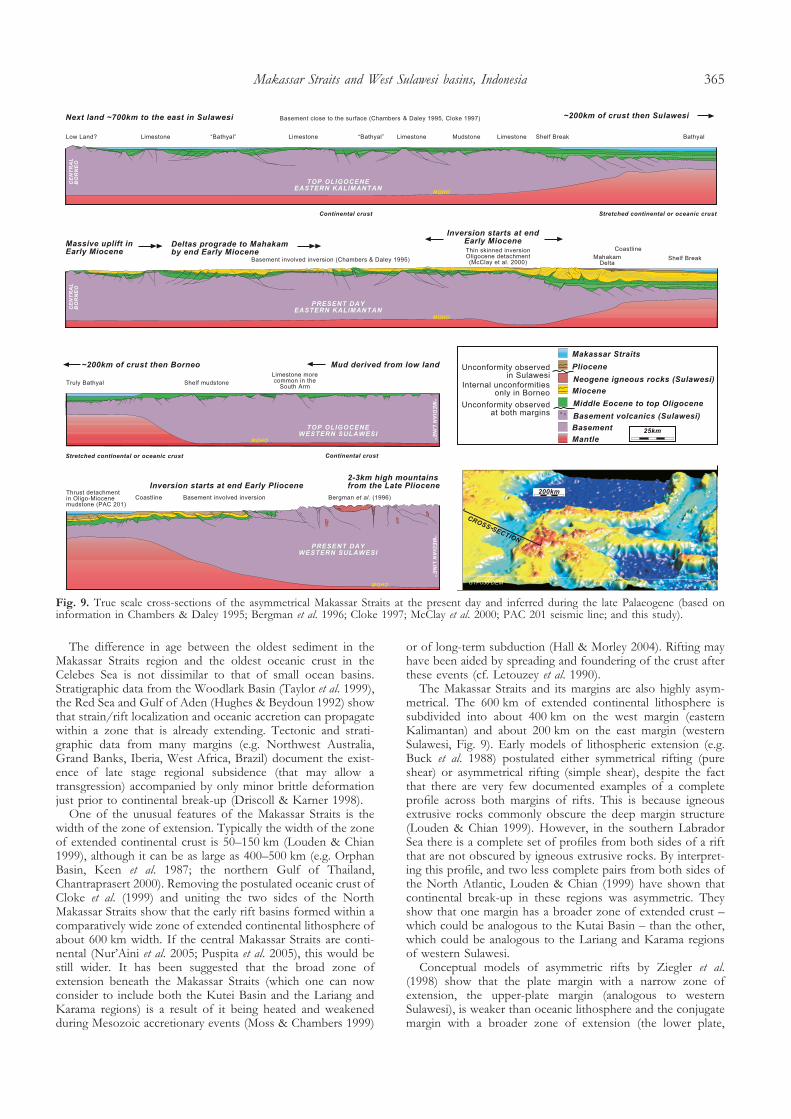
The Palaeogene shelf in western Sulawesi may subsequentlyhave been modified and removed by Late Neogene compres-sion and uplift. However, it is believed that the eastern limit ofthe Palaeogene shelf cannot have been positioned any furthereast than the present-day ‘Median Line’ (Brouwer 1934;Brouwer et al. 1947), which is thought to have been a majorPalaeogene structure (Parkinson 1991). This eastern limit liesno more than approximately 200 km to the east of the presentcoastline of the Lariang and Karama region.
The distance from the former shelf to the deep central partof the Makassar Straits is much less than that from the
equivalent shelf in Kalimantan (Fig. 9). Not only do the basinsin eastern Kalimantan record deep-water Palaeogene fill, theyalso cover a much wider area than those in western Sulawesi.The zone of early Cenozoic extension was. in fact. about twiceas wide in eastern Kalimantan (c. 400 km, Cloke 1997;>100 km, Moss & Chambers 2000) than it was in westernSulawesi (Fig. 9, see also reconstructions in Wilson & Moss1999). At the end of the Oligocene the Makassar Straits wasapproximately 800–900 km wide, which is considerably widerthan the present-day width of 250–300 km.Palaeogene–Neogene contact The Palaeogene–Neogene section isdifficult to date due to the lack of numerous key taxa (E. Finch,pers. comm. 2000). The upper part of the Toraja Group andthe lower part of the Lisu Formation are lithologically similar asthey are both made up of mudstones. The Early to MiddleMiocene sea-level drop on the eustatic curve, which is reportedfrom the basins of SE Asia (Longley 1997), may have exposedthe type area and eroded Lower and Middle Miocene sedi-ments, thus forming a disconformity between the Toraja Groupand the Lisu Formation. This part of the stratigraphy is alsorelatively condensed in comparison to the younger Neogeneand older Palaeogene. There could be a local detachment in thestudy area which could explain why it has been inferred byothers that there is an unconformity at this level of thestratigraphy (e.g. Norvick & Pile 1976). However, there is noevidence for an early Neogene regional unconformity in anyother parts of western Sulawesi (Grainge & Davies 1983;Coffield et al. 1993, 1997; Bergman et al. 1996; Guritno et al.1996; Pertamina 1996; Wilson et al. 2000) and the contact hasbeen interpreted here to be conformable (Fig. 2).Comparison with other rifted margins The timing of early Cenozoicbasin development is similar throughout the Makassar Straitsregion on both margins of the North Makassar Basin. Exten-sion started sometime in the early Cenozoic. Non-marinesyn-rift sediments may date from the Paleocene, in which casethe ‘pre-break-up’ extensional phase could have started as earlyas c. 60 Ma. However, the oldest dated syn-rift deposits in thestudy area and the Kutai Basin are Middle Eocene marinesediments, NP15 (48.1–43.9 Ma) and P11–P12 (47.2–41.4 Ma;Cloke 1997), respectively, suggesting extension started by about50 Ma. The development of oceanic crust immediately north ofthe Makassar Straits basin in the Celebes Sea is estimated asstarting around 44 Ma (magnetic anomaly C20; Hall 1996) but itis possible that older crust has been subducted at the Sulutrench. The oldest Cenozoic oceanic crust in the region may beyounger than the oldest dated Cenozoic sediment. Thus, thepre-break-up extensional phase could have lasted for up to15 Ma or could have been as short as 5 Ma.
It is not clear if the oceanic crust propagated into the NorthMakassar Straits, as magnetic anomalies have not been ident-ified using any potential field data. In the South MakassarStraits there is no evidence to suggest that rifting reached thestage of oceanic spreading (Burollet & Salle 1981; Situmorang1982, 1984; Wismann 1984; Wilson 1999) and highly attenuatedcontinental crust is inferred to underlie this basin (Wilson2000). Both sides of the South Makassar Straits were shallow-marine carbonate platforms until the Early Miocene (Wilson &Moss 1999). Recent seismic studies suggest attenuated conti-nental rather than oceanic crust in the central North MakassarStraits (Nur’Aini et al. 2005; Puspita et al. 2005). Whether the riftwas abortive or successful (Ziegler & Cloetingh 2004), west ofLariang and Karama the rifting stage did last for a period of5–10 Ma and the North Makassar Basin is situated betweenattenuated continental crust in the South Makassar Basin andoceanic crust in the Celebes Sea.
S. J. Calvert & R. Hall364
The difference in age between the oldest sediment in theMakassar Straits region and the oldest oceanic crust in theCelebes Sea is not dissimilar to that of small ocean basins.Stratigraphic data from the Woodlark Basin (Taylor et al. 1999),the Red Sea and Gulf of Aden (Hughes & Beydoun 1992) showthat strain/rift localization and oceanic accretion can propagatewithin a zone that is already extending. Tectonic and strati-graphic data from many margins (e.g. Northwest Australia,Grand Banks, Iberia, West Africa, Brazil) document the exist-ence of late stage regional subsidence (that may allow atransgression) accompanied by only minor brittle deformationjust prior to continental break-up (Driscoll & Karner 1998).
One of the unusual features of the Makassar Straits is thewidth of the zone of extension. Typically the width of the zoneof extended continental crust is 50–150 km (Louden & Chian1999), although it can be as large as 400–500 km (e.g. OrphanBasin, Keen et al. 1987; the northern Gulf of Thailand,Chantraprasert 2000). Removing the postulated oceanic crust ofCloke et al. (1999) and uniting the two sides of the NorthMakassar Straits show that the early rift basins formed within acomparatively wide zone of extended continental lithosphere ofabout 600 km width. If the central Makassar Straits are conti-nental (Nur’Aini et al. 2005; Puspita et al. 2005), this would bestill wider. It has been suggested that the broad zone ofextension beneath the Makassar Straits (which one can nowconsider to include both the Kutei Basin and the Lariang andKarama regions) is a result of it being heated and weakenedduring Mesozoic accretionary events (Moss & Chambers 1999)
or of long-term subduction (Hall & Morley 2004). Rifting mayhave been aided by spreading and foundering of the crust afterthese events (cf. Letouzey et al. 1990).
The Makassar Straits and its margins are also highly asym-metrical. The 600 km of extended continental lithosphere issubdivided into about 400 km on the west margin (easternKalimantan) and about 200 km on the east margin (westernSulawesi, Fig. 9). Early models of lithospheric extension (e.g.Buck et al. 1988) postulated either symmetrical rifting (pureshear) or asymmetrical rifting (simple shear), despite the factthat there are very few documented examples of a completeprofile across both margins of rifts. This is because igneousextrusive rocks commonly obscure the deep margin structure(Louden & Chian 1999). However, in the southern LabradorSea there is a complete set of profiles from both sides of a riftthat are not obscured by igneous extrusive rocks. By interpret-ing this profile, and two less complete pairs from both sides ofthe North Atlantic, Louden & Chian (1999) have shown thatcontinental break-up in these regions was asymmetric. Theyshow that one margin has a broader zone of extended crust –which could be analogous to the Kutai Basin – than the other,which could be analogous to the Lariang and Karama regionsof western Sulawesi.
Conceptual models of asymmetric rifts by Ziegler et al.(1998) show that the plate margin with a narrow zone ofextension, the upper-plate margin (analogous to westernSulawesi), is weaker than oceanic lithosphere and the conjugatemargin with a broader zone of extension (the lower plate,
Fig. 9. True scale cross-sections of the asymmetrical Makassar Straits at the present day and inferred during the late Palaeogene (based oninformation in Chambers & Daley 1995; Bergman et al. 1996; Cloke 1997; McClay et al. 2000; PAC 201 seismic line; and this study).
Makassar Straits and West Sulawesi basins, Indonesia 365
analogous to eastern Kalimantan). They suggest that the upperplate margin (western Sulawesi) is the most likely candidate forcompressional reactivation. Reactivation, which started in thelatest Early Pliocene in most of Sulawesi, is also apparent fromthe new geological mapping described in this paper (Fig. 3).The contraction is related to the collision of the Banggai–Sulamicrocontinent with eastern Sulawesi. In western, central andthe east arm of Sulawesi there are Plio-Pleistocene sedimentaryrocks, often referred to as ‘molasse’ or ‘synorogenic sediments’,which are also related to the arrival of this fragment (e.g.Hundling 1942; Davies 1990; Coffield et al. 1993; Guritno et al.1996; Purnomo et al. 1999; Sudarmono 2000). The Plioceneorogeny in Sulawesi resulted in development of the present-daymountains, which are up to 3 km high. Since the Pliocene,crustal movements in Sulawesi have been accommodated in apredominantly sinistral wrench-fault system that cuts throughthe whole island. These faults include reactivated NW–SEPalaeogene transform faults within the study area.
CONCLUSIONS
Two major unconformities were identified in this study of theLariang and Karama regions of western Sulawesi: one betweenUpper Cretaceous basement rocks and Eocene shelf sediments,and a younger one between Lower Pliocene shelf sedimentsand Plio-Pleistocene syn-orogenic sediments. Non-marine sedi-ments at the base of the lower Cenozoic sections could be asold as the Paleocene, but the oldest dated sediments are marineand record a transgression in the Middle Eocene that mustpost-date the initiation of rifting in the region. The Eocenesediments were deposited in graben and half-graben in bothmarine and marginal marine environments. The MakassarStraits Eocene rift was highly asymmetrical. The zone ofextension of the western margin (Kalimantan) was approxi-mately twice as wide as that of the eastern margin (Sulawesi).The post-rift subsidence phase had started by the Late Eocene.In the Late Eocene carbonate shoals and shelf mudstonesdeveloped on both margins of the Makassar Straits and, by theend of the Oligocene, most of western Sulawesi was an area ofshelf carbonate and mudstone deposition. During the EarlyMiocene microcontinental fragments collided with the SE armof Sulawesi but, in western Sulawesi, there is no evidence for abreak in marine deposition in the South Arm. In the study areathe lowermost Miocene has not been found but there is noevidence in western Sulawesi for either a significant regionalunconformity, or input of orogenic sediment. Instead, through-out the Early Miocene and, in places, until the Middle or LateMiocene, carbonates and mudstones were deposited on ashallow-marine continental margin. Early Miocene collisions ineastern Sulawesi did not cause orogeny in western Sulawesi. Itwas only during the Pliocene that the character of sedimenta-tion across the whole of western, central and eastern Sulawesichanged significantly. Uplift and erosion was followed by thedeposition of coarse clastics derived from an orogenic belt tothe east of the study area. To the west of the orogenic belt therewas syn-orogenic sedimentation, inversion and folding abovePalaeogene half-graben, detachment folding and thrusting, andthe development of intra-basinal unconformities and mini-basins. In the Late Pliocene the study area changed from apassive margin to a foreland basin setting and sedimenta-tion rates doubled. The contractional deformation of westernSulawesi dates from the Pliocene, whereas that on the oppositeside of the Makassar Straits in eastern Kalimantan began in theEarly Miocene, indicating they have different causes. Inversionin Kalimantan was not driven by deformation to the east inSulawesi.
The project on which this manuscript is based ran from 1996–2000and was funded by Amerada Hess and the SE Asia Research Groupat Royal Holloway supported by a consortium of oil companies.Logistical field support was provided by Mac Endharto, GRDC,Bandung, Indonesia. Unocal Indonesia are acknowledged for allow-ing a return to the field area in 2001. The authors thank Mike Cottamwho helped greatly in the final preparation of the figures.
REFERENCES
Ali, J.R., Milsom, J., Finch, E.M. & Mubroto, B. 1996. SE SundalandAccretion: Palaeomagnetic evidence of large Plio-Pleistocene thin-skinrotations in Buton. In: Hall, R. & Blundell, D. (eds) Tectonic Evolution ofSoutheast Asia. Geological Society, London, Special Publications, 106,431–443.
Ascaria, N.A. 1997. Carbonate facies development and sedimentary evolution of theMiocene Tacipi Formation, South Sulawesi, Indonesia. PhD thesis. University ofLondon.
Audley-Charles, M.G., Ballantyne, P.D. & Hall, R. 1988. Mesozoic–Cenozoicrift–drift sequence of Asian fragments from Gondwanaland. Tectonophysics,155, 317–330.
Bellier, O., Beaudoin, T., Sebrier, M. et al. 1998. Active faulting in centralSulawesi (eastern Indonesia). In: Wilson, P. & Michel, G.W. (eds) TheGeodynamics of S and SE Asia (GEODYSSEA Project). GeoForschingsZentrum, Potsdam, Germany, 276–312.
Beltz, E.W. 1944. Principal sedimentary basins in the East Indies. AmericanAssociation of Petroleum Geologists Bulletin, 28, 1440–1454.
Bergman, S.C., Talbot, J.P. & Garrard, R.A. 1992. Miocene Magmatism andThermal History in the Kalosi Block and Adjacent S.W. Sulawesi: Evidenceof Miocene Continental Collision (unpublished report). ARCO Oil andGas Company, Plano, TSR92-0038.
Bergman, S.C., Coffield, D.Q., Talbot, J.P. & Garrard, R.J. 1996. TertiaryTectonic and Magmatic Evolution of western Sulawesi and the MakassarStrait, Indonesia: Evidence for a Miocene Continent–Continent Collision.In: Hall, R. & Blundell, D.J. (eds) Tectonic Evolution of Southeast Asia.Geological Society, London, Special Publications, 106, 391–430.
Bolli, H.M., Saunders, J.B. & Perch-Nielsen, K. 1985. Plankton Stratigraphy.Cambridge Earth Science Series. Cambridge University Press, Cambridge.
Bransden, P.J.E. & Matthews, S.J. 1992. Structural and stratigraphic evolutionof the East Java Sea, Indonesia. Proceedings Indonesian Petroleum Association,21st Annual Convention, Jakarta, 417–454.
Brouwer, H.A. 1934. Geologische onderzoekingen op het eiland Celebes.Verhandelingen Koninklijk Nederlands Geologisch en Mijnbouwkundig Genootschap.Geologische Serie, V (10), 39–218.
Brouwer, H.A., Hetzel, W.H. & Straeter, H.E.G. 1947. Geological Explorationsin the Island of Celebes. North Holland Publishing Co, Amsterdam.
Buck, W.R., Steckler, M.S. & Cochran, J.R. 1988. Thermal Consequences ofLithospheric extension: Pure and Simple. Tectonics, 7, 213–234.
Burollet, P.F. & Salle, C. 1981. Seismic reflection profiles in the MakassarStrait. In: Barber, A.J. & Wiryosujono, S. (eds) The Geology and Tectonics ofEastern Indonesia. Geological Research and Development Centre, Bandung,Special Publication, 2, 273–276.
Calvert, S.J. 2000. The Cenozoic Geology of the Lariang and Karama regions, westernSulawesi, Indonesia. PhD thesis. University of London.
Calvert, S.J. & Hall, R. 2003. The Cenozoic geology of the Lariang andKarama regions, western Sulawesi: New insight into the evolution of theMakassar Straits region. Proceedings Indonesian Petroleum Association 29thAnnual Convention, 501–517.
Calvert, S. J. & Terry, F.E.M. 2001. Geological Field Trip Guide of the UnocalWest Sulawesi East Makassar Study Area. Unpublished Oil Company Report.
Chamberlain, M. & Seago, R. 1995. Geological Evaluation of the Lariang PSCarea, South Sulawesi. Unpublished report, Amoseas International.
Chambers, J.L.C. & Daley, T.E. 1995. A tectonic model for the onshoreKutai Basin, East Kalimantan, based on an integrated geological andgeophysical interpretation. Proceedings Indonesian Petroleum Association, 24thAnnual Convention, 111–130.
Chantrapresert, S. 2000. Extensional faults and fault linkages, southern PattaniBasin, Gulf of Thailand. PhD thesis. University of London.
Charlton, T.R. 2000. Tertiary evolution of the eastern Indonesian collisioncomplex. Journal of Asian Earth Sciences, 18, 603–631.
Cloke, I.R. 1997. Structural controls on the basin evolution of the Kutai Basin and theMakassar Straits. PhD thesis. University of London.
Cloke, I.R., Moss, S.J. & Craig, J. 1997. The influence of basementreactivation on the extensional and inversional history of the Kutai Basin,East Kalimantan, SE Asia. Journal of the Geological Society, London, 154,157–161.
Cloke, I.R., Milsom, J. & Blundell, D.J.B. 1999. Implications of gravity datafrom East Kalimantan and the Makassar Straits: a solution to the origin ofthe Makassar Straits? Journal of Asian Earth Sciences, 19, 61–78.
S. J. Calvert & R. Hall366
Coffield, D.Q., Bergman, S.C., Garrard, R.A., Guritno, N., Robinson, N.M. &Talbot, J. 1993. Tectonic and stratigraphic evolution of the Kalosi PSC areaand associated development of a Tertiary petroleum system, SouthSulawesi, Indonesia. Proceedings Indonesian Petroleum Association, 22nd AnnualConvention, 679–706.
Coffield, D.Q., Guritno, N., Wilson, M. & Ascaria, A. 1997. Petroleum systemsof South Sulawesi, Indonesia. In: Howes, J.V.C. & Noble, R.A. (eds)Proceedings of the Petroleum Systems of SE Asia and Australasia InternationalConference, May 21–23. Indonesian Petroleum Association, 1001–1010.
Daly, M.C., Cooper, M.A., Wilson, I., Smith, D.G. & Hooper, B.G.D. 1991.Cenozoic plate tectonics and basin evolution in Indonesia. Marine andPetroleum Geology, 8, 2–21.
Davies, I.C. 1990. Geology and exploration review of the Tomori PSC,Eastern Indonesia. Proceedings Indonesian Petroleum Association 19th AnnualConvention, 41–68.
Djuri, M. & Sudjatmiko 1974. Geologic map of the Majene and western partof the Palopo quadrangles, South Sulawesi, (Quadrangles 17/X – 18/8), Scale1:250,000. Geological Research and Development Centre, Bandung,Indonesia.
Driscoll, N.W. & Karner, G.D. 1998. Lower crustal extension across theNorthern Carnarvon basin, Australia: Evidence for an eastward dippingdetachment. Journal of Geophysical Research, 103 (B3), 4975–4991.
Evans, M. J. 1991. Geological Field Survey of Onshore PSC and adjacentareas, Sulawesi, Indonesia, with specific reference to Eocene Reservoirquality and distribution. Unpublished report, BP Petroleum Developmentof Indonesia Ltd.
Faroppa, J.L. 1998. Classification and Evolution of Regional Structures, SW KutaiBasin, Indonesia. MSc thesis. Royal Holloway University of London.
Feriansyah, L.T., Chambers, J.L.C., Dewantohadi, S.H., Syaiful, M.,Priantono, T. & Imanhardjo, D.N. 2000. Structural and stratigraphicframework of the Paleogene in the northern Kutei Basin East Kalimantan.Proceedings Indonesian Petroleum Association, 27th Annual Convention, 444–455.
Fraser, T.H. & Ichram, L.O. 2000. Significance of the Celebes Sea spreadingcentre to the Palaeogene petroleum systems of the SE Sunda margin,central Indonesia. Proceedings Indonesian Petroleum Association, 27th AnnualConvention, 431–441.
Fuller, M., Ali, J.R., Moss, S.J., Frost, G.M., Richter, B. & Mahfi, A. 1999.Palaeomagnetism of Borneo. Journal of Asian Earth Sciences, 17, 3–24.
Garrard, R.A., Nusatriyo, G. & Coffield, D.Q. 1992. The prospectivity ofearly Tertiary rift sequences in the Neogene foldbelts of South Sulawesi.The Eastern Indonesia Exploration Symposium, Jakarta, April 29, 1–12.
Grainge, A.M. & Davies, K.G. 1983. Reef exploration in East SangkangBasin, Sulawesi. Proceedings Indonesian Petroleum Association, 12th AnnualConvention, 207–228.
Guntoro, A. 1999. The formation of the Makassar Straits and the separationbetween SE Kalimantan and SW Borneo. Journal of Asian Earth Sciences, 17,79–98.
Guritno, N., Coffield, D.Q. & Cook, R.A. 1996. Structural Development ofCentral South Sulawesi, Indonesia. Proceedings Indonesian Petroleum Association,25th Annual Convention, 253–266.
Hadiwijoyo, S., Sukarna, D. & Sutisna, K. 1993. Geology of the PasangkayuQuadrangle, Sulawesi. (Quadrangle 2014) Scale 1:250,000. Geological Researchand Development Centre, Bandung, Indonesia.
Hall, R. 1996. Reconstructing Cenozoic SE Asia. In: Hall, R. & Blundell, D.J.(eds) Tectonic Evolution of Southeast Asia. Geological Society, London, SpecialPublications, 106, 153–184.
Hall, R. & Morley, C.K. 2004. Sundaland Basins. In: Clift, P.D., Wang, P.,Kuhnt, W. & Hayes, D. (eds) Continent–Ocean Interactions within East AsianMarginal Seas. AGU Geophysical Monograph Series, 149, 55–86.
Hall, R. & Wilson, M.E.J. 2000. Neogene sutures in eastern Indonesia. Journalof Asian Earth Sciences, 18, 781–808.
Hamilton, W. 1979. Tectonics of the Indonesian region. United States GeologicalSurvey Professional Paper, 1078.
Haq, B.U., Hardenbol, J. & Vail, P.R. 1987. Chronology of fluctuating sealevels since the Triassic. Science, 235, 1156–1167.
Harland, W.B., Armstrong, R.L., Cox, A.V., Craig, L.E., Smith, A.G. & Smith,D.G. 1990. A Geologic Time Scale 1989. Cambridge University Press,Cambridge.
Hasan, K. 1990. The Upper Cretaceous flysch succession of the Balangbaru Formation,Southwest Sulawesi, Indonesia. PhD thesis. University of London.
Hasan, K. 1991. Upper Cretaceous flysch succession of the BalangbaruFormation, Southwest Sulawesi. Proceedings Indonesian Petroleum Association,20th Annual Convention, 183–208.
Hasan, K. 1992. The Upper Cretaceous flysch succession of the BalangbaruFormation, southwest Sulawesi, Indonesia. Journal of Southeast Asian EarthSciences, 7, 268.
Hughes, G.W. & Beydoun, Z.R. 1992. The Red Sea–Gulf of Aden:biostratigraphy, lithostratigraphy and palaeoenvironments. Journal of Petro-leum Geology, 15, 135–156.
Hundling, I.E. 1942. Oil-possibilities in Ceram, New Guinea, Celebes, andBoeton. Geological Survey Report 1942, Arch. Bur. of Mines 37/dy. In:
van Bemmelen, R.W. (ed.) The Geology of Indonesia. Vol. 2: Economic Geology,fig. 10, p. 39.
Hutchison, C.S. 1996. The ‘Rajang Accretionary Prism’ and ‘Lupar Line’Problem of Borneo. In: Hall, R. & Blundell, D.J. (eds) Tectonic Evolution ofSoutheast Asia. Geological Society, London, Special Publications, 106,247–261.
Jackson, B.A. 2004. Seismic Evidence for gas hydrates in the North MakassarBasin, Indonesia. Petroleum Geoscience, 10, 227–238.
Kartaadiputra, L.W., Ahmad, Z. & Reymond, A. 1982. Deep-Sea Basins inIndonesia. Proceedings Indonesian Petroleum Association, 11th Annual Convention,53–81.
Keen, C.E., Stockmal, G.S., Welsink, H., Qinlan, G. & Mudfod, B. 1987.Deep crustal structure and evolution of the rifted margin northeast ofNewfoundland: results from Lithoprobe East. Canadian Journal of EarthScience, 24, 1537–1550.
Kominz, M.A., Miller, K.G. & Brown, J.V. 1998. Long-term and short-termglobal Cenozoic sea level estimates. Geology, 26, 311–314.
Kusuma, I. & Darin, T. 1989. The hydrocarbon potential of the LowerTanjung Formation, Barito Basin, S. E. Kalimantan. Proceedings IndonesianPetroleum Association, 18th Annual Convention, 107–138.
Letouzey, J., Werner, P. & Marty, A. 1990. Fault reactivation and structuralinversion; backarc and intraplate compressive deformations; example ofthe eastern Sunda Shelf (Indonesia). Tectonophysics, 183, 341–362.
Longley, I.M. 1997. The Tectonostratigraphic evolution of SE Asia. In: Fraser,A.J., Matthews, S.J. & Murphy, R.W. (eds) Petroleum Geology of Southeast Asia.Geological Society, London, Special Publications, 126, 311–339.
Louden, K.E. & Chian, D. 1999. The deep structure of non-volcanic riftedcontinental margins. Philosophical Transactions of the Royal Society of London,357A, 767–804.
McCabe, R. & Cole, J. 1987. Speculations on the Late Mesozoic andCenozoic evolution of the south east Asian margin. In: Horn, M.K. (ed.)Transactions of the 4th Circum-Pacific Energy and Mineral Resources Conference,Singapore, 1986, 375–394.
McClay, K.R., Dooley, T., Ferguson, A. & Poblet, J. 2000. TectonicEvolution of the Sanga Sanga Block, Mahakam Delta, Kalimantan,Indonesia. American Association of Petroleum Geologists Bulletin, 84, 765–786.
Metcalfe, I. 1996. Pre-Cretaceous Evolution of SE Asian Terranes. In: Hall,R. & Blundell, D.J. (eds) Tectonic Evolution of Southeast Asia. GeologicalSociety, London, Special Publications, 106, 97–122.
Moss, S.J. & Chambers, J.L.C. 1999. Tertiary facies architecture in the KutaiBasin, Kalimantan, Indonesia. Journal of Asian Earth Sciences, 17, 157–181.
Moss, S.J. & Chambers, J.L.C. 2000. Depositional modelling and faciesarchitecture of rift and inversion episodes in the Kuyai basin, Kalimantan,Indonesia. Proceedings Indonesian Petroleum Association, 27th Annual Conference,467–486.
Moss, S.J. & Finch, E.M. 1997. Geological implications of new biostrati-graphic data from East and West Kalimantan, Indonesia. Journal of AsianEarth Sciences, 15, 489–506.
Moss, S.J., Chambers, J.L.C., Cloke, I., Carter, A., Dharma, S., Ali, J.R. &Baker, S. 1997. New observations on the sedimentary and tectonicevolution of the Tertiary Kutai Basin, East Kalimantan. In: Fraser, A.J.,Matthews, S.J. & Murphy, R.W. (eds) Petroleum Geology of SE Asia.Geological Society, London, Special Publications, 126, 395–416.
Norvick, M.S. & Pile, R.L. 1976. Field report on the Lariang and KaramaGeological Survey West Sulawesi. BP Petroleum Development ofIndonesia Ltd, unpublished Report no.JKT/EXP/0071.
Nur’Aini, S., Hall, R. & Elders, C.F. 2005. Basement architecture andsedimentary fills of the North Makassar Straits basin. Proceedings IndonesianPetroleum Association, 30th Annual Convention, 483–497.
OTCA (Overseas Technical Corporation of Japan) 1971. UnpublishedTechnical Report of the Geological Survey of West Sulawesi.
Parkinson, C.D. 1991. The petrology, structure and geologic history of the metamorphicrocks of Central Sulawesi, Indonesia. PhD thesis. University of London.
Parkinson, C.D. 1998. Emplacement of the East Sulawesi Ophiolite: Evi-dence from subophiolitic metamorphic rocks. Journal of SE Asian EarthSciences, 16, 13–28.
Parkinson, C.D., Miyazaki, K., Wakita, K., Barber, A.J. & Carswell, D.A.1998. An overview and tectonic synthesis of the pre-Tertiary very-highpressure metamorphic and associated rocks of Java, Sulawesi and Kaliman-tan, Indonesia. Island Arc, 7, 184–200.
Pertamina 1996. Eastern Indonesian Basins. Petroleum Geology of IndonesianBasins. Pertamina, Jakarta, 6–9.
Purnomo, E., Tony, S.P. & Luthfi, A. 1999. Relative age indicator of Sulawesicollision zone, eastern arm of Sulawesi (Abstract). In: Darman, H. & Sidi,F.H. (eds) Tectonics and Sedimentation of Indonesia. FOSI-IAGI ITB RegionalSeminar, 15–17 March, 76–78.
Puspita, S.D., Hall, R. & Elders, C.F. 2005. Structural styles of the offshoreWest Sulawesi fold belt, North Makassar Straits, Indonesia. ProceedingsIndonesian Petroleum Association, 30th Annual Convention, 519–542.
Makassar Straits and West Sulawesi basins, Indonesia 367
Ratman, N. & Atmawinata, S. 1993. Geology of the Mamuju Quadrangle, Sulawesi.Scale 1:250,000. Geological Research and Development Centre, Bandung,Indonesia.
Reyzer, J. 1920. Geologische aanteekeningen betreffende de ZuidelijkeToraja-landen, verzameld uit de verslagen der mijnbouwkundige onder-zoekingen in Midden-Celebes. Jaarboekh Mijnwezen Nederlandsch Oost-Indie1918. Government Printing Office, Weltevreden, 154–209.
Samuel, L., Purnomo, J., Bertange, A.J. & Smith, N.G. 1996. Results frominterpretation of regional transects in central Indonesia. The Leading Edge,April, 261–266.
Satyana, A.H., Nugroho, D. & Surantoko, I. 1999. Tectonic controls on thehydrocarbon habitats of the Barito, Kutei, and Tarakan Basins, EasternKalimantan, Indonesia: major dissimilarities in adjoining basins. Journal ofAsian Sciences, 17, 99–122.
Sikumbang, N. 1990. The geology and tectonics of the Meratus Mountains,South Kalimantan, Indonesia. Geologi Indonesia. Journal of the IndonesianAssociation of Geologists, 13, 1–31.
Simandjuntak, T.O. & Barber, A.J. 1996. Contrasting Tectonic Styles in theNeogene Orogenic Belts of Indonesia. In: Hall, R. & Blundell, D.J. (eds)Tectonic Evolution of Southeast Asia. Geological Society, London, SpecialPublications, 106, 185–201.
Simandjuntak, T.O., Rusmana, E., Surono & Supandjono, J.B. 1991a. Thegeology of the Malili quadrangle, Sulawesi (Quadrangle 2113), Scale 1: 250,000.Geological Research and Development Centre, Bandung, Indonesia.
Simandjuntak, T.O., Surono & Supandjono, J.B. 1991b. The geology of the Posoquadrangle, Sulawesi (Quadrangle 2114), Scale 1:250,000. Geological Researchand Development Centre, Bandung, Indonesia.
Situmorang, B. 1982. The Formation and Evolution of the Makassar Basin,Indonesia. PhD thesis. University of London.
Situmorang, B. 1984. Formation, evolution, and hydrocarbon prospects ofthe Makassar Basin, Indonesia. Proceedings of the 3rd Circum Pacific Energy andMinerals Research Conference, 227–231.
Soeria-Atmadja, R., Suparka, S., Abdullah, C., Noerdi, D. & Sutano, X. 1998.Magmatism in western Indonesia, the trapping of the Sumba block andthe gateways to the east of Sundaland. Journal of Asian Earth Sciences, 16,1–12.
Sopaheluwakan, J., Kadarusman, A., Priadi, B. & Utoyo, H. 1995. The natureof the basement rocks in the Palu region, Central Sulawesi: The newlyfound eclogite and its regional implication. Proceedings of the Sixth InternationalCongress on Pacific Neogene Biostratigraphy and IGCP –355: Neogene Evolution ofPacific: Biotic, Oceanographic and Tectonic Development, 73–79.
Sudarmono 2000. Tectonic and stratigraphic evolution of the Bone Basin,Indonesia: insights to the Sulawesi collision complex. Proceedings IndonesianPetroleum Association, 27th Annual Convention, 531–543.
Sudrajat, A. 1981. Penyelidikan Geologi Lembah Palu, Sulawesi Tengah, denganteknik penginderaan jauh. ITB, Bandung, Indonesia.
Sukamto, R. 1973. Reconnaissance geologic map of Palu Area, Sulawesi – scale1:250,000. Open File Report. Geological Research and DevelopmentCentre, Bandung, Indonesia.
Sukamto, R. 1975. Geological map of Indonesia, Ujung Pandang sheet – Scale1:1,000,000. Geological Research and Development Centre, Bandung,Indonesia.
Tanean, H., Paterson, D.W. & Endarto, M. 1996. Source provenanceinterpretation of Kutei Basin sandstones and the implications for thetectono-stratigraphic evolution of Kalimantan. Proceedings Indonesian Petro-leum Association, 25th Annual Convention, 333–345.
Taylor, B., Goodliffe, A.M. & Martinez, F. 1999. How continents break up:Insights from Papua New Guinea. Journal of Geophysical Research, 104,7497–7512.
Untung, M. & Indonesian Working Group on Gravity and Magnetics 1983.Explanation Note on Preliminary Aeromagnetic Map of the MakassarStraits. CCOP 20th Session, Kuala Lumpur 17–18 November, 13.
Wain, T. & Berod, B. 1989. The tectonic framework and paleogeographicevolution of the Upper Kutei Basin. Proceedings Indonesian Petroleum Associ-ation, 18th Annual Convention, 55–78.
Wakita, K., Sopaheluwakan, J., Miyazaki, K., Zulkarnain, I. & Munasri 1996.Tectonic Evolution of the Bantimala Complex, South Sulawesi, Indonesia.In: Hall, R. & Blundell, D.J. (eds) Tectonic Evolution of Southeast Asia.Geological Society, London, Special Publications, 106, 353–364.
Walpersdorf, A. & Vigny, C. 1998. Monitoring of the Palu–Koro Fault(Sulawesi) by GPS. Geophysical Research Letters, 25, 2313–2316.
Walpersdorf, A., Rangin, C. & Vigny, C. 1998. GPS compared to long-termgeologic motion of the north arm of Sulawesi. Earth and Planetary ScienceLetters, 159, 47–55.
Wilson, M.E.J. 1999. Prerift and synrift sedimentation during early faultsegmentation of a Tertiary carbonate platform, Indonesia. Marine andPetroleum Geology, 16, 825–848.
Wilson, M.E.J. 2000. Tectonic and volcanic influences on the developmentand diachronous termination of a Tertiary tropical carbonate platform.Journal of Sedimentary Research, 70, 310–324.
Wilson, M.E.J. & Bosence, D.W.J. 1996. The Tertiary evolution of SouthSulawesi: A record in redeposited carbonates of the Tonasa LimestoneFormation. In: Hall, R. & Blundell, D.J. (eds) Tectonic Evolution of SoutheastAsia. Geological Society, London, Special Publications, 106, 365–389.
Wilson, M.E.J. & Moss, S.J. 1999. Cenozoic palaeogeographic evolution ofSulawesi and Borneo. Palaeogeography, Palaeoclimatology, Palaeoecology, 145,303–337.
Wilson, M.E.J., Bosence, D.W.J. & Limbong, A. 2000. Tertiary syntectoniccarbonate platform development in Indonesia. Sedimentology, 47, 367–394.
Wismann, G. 1984. Makassar Straits – Celebes Sea survey, data compilation andinterpretation of cruises, Valdivia, 16/; Sonne16/1981. BGR Technical Report,97.
Ziegler, P.A. & Cloetingh, S. 2004. Dynamic processes controlling theevolution of rifted basins. Earth Science Reviews, 64, 1–50.
Ziegler, A.M., vanWees, J.D. & Cloetingh, S. 1998. Mechanical controls oncollision-related compressional intraplate deformation. Tectonophysics, 300,103–129.
van Bemmelen, R.W. 1949. The Geology of Indonesia. Government PrintingOffice, Nijhoff, The Hague.
van Leeuwen, T.M. 1981. The geology of southwest Sulawesi with specialreference to the Biru area. In: Barber, A.J. & Wiryosujono, S. (eds) TheGeology and Tectonics of Eastern Indonesia. Geological Research and Develop-ment Centre, Publication, 2, 277–304.
van de Weerd, A. & Armin, R.A. 1992. Origin and evolution of the Tertiaryhydrocarbon bearing basins in Kalimantan (Borneo), Indonesia. AmericanAssociation of Petroleum Geologists Bulletin, 76, 1778–1803.
van de Weerd, A., Armin, R.A., Mahadi, S. & Ware, P.L.B. 1987. Geologicsetting of the Kerendan gas and condensate discoveryTertiary sedimentarygeology and paleogeography of the northwestern part of the Kutei Basin,Kalimantan, Indonesia. Proceedings Indonesian Petroleum Association, 16thAnnual Convention, 317–338.
Received 6 August 2006; revised typescript accepted 5 May 2007.
S. J. Calvert & R. Hall368