BY QUINTA SCOTT
18
16 | The Confluence | Spring/Summer 2012 It’s some of the richest farmland in the country, but it wants to be a wetland and flood storage area. Therein lies the conflict that has bedeviled farmers on the American Bottom for a thousand years or more. Once again: Cross the Jefferson Barracks Bridge from St. Louis County, Missouri, into Monroe County, Illinois. Exit onto Illinois Route 3. Turn right on Sand Bank Road and descend the hill to Bluff Road. Spread out before you is the American Bottom, that vast Mississippi River floodplain that extends from Alton to the Kaskaskia River, across which the river once meandered in several different channels, depositing rich alluvial soil and leaving behind wetlands before settling in its modern regime. This is the second of three articles on the interrelated elements of the American Bottom: the sinkhole plain and bluffs; the bottomland floodplain between the bluffs and the river levees; and the batture lands beyond the levees, the islands, and the river’s edge. AMERICAN BOTTOM: The Floodplain between the Bluffs and the Levee BY QUINTA SCOTT Top image—The Discharge: Modoc, April 1993 Bottom image—Modoc Rock Shelter
Transcript of BY QUINTA SCOTT

16 | The Confluence | Spring/Summer 2012
It’s some of the richest farmland in the country, but it wants to be a wetland and flood storage area. Therein lies the conflict that has bedeviled farmers on the American Bottom for a thousand years or more. Once again: Cross the Jefferson Barracks Bridge from St. Louis County, Missouri, into Monroe County, Illinois. Exit onto Illinois Route 3. Turn right on Sand Bank Road and descend the hill to Bluff Road. Spread out before you is the American Bottom, that vast Mississippi River floodplain that extends from Alton to the Kaskaskia River, across which the river once meandered in several different channels, depositing rich alluvial soil and leaving behind wetlands before settling in its modern regime. This is the second of three articles on the interrelated elements of the American Bottom: the sinkhole plain and bluffs; the bottomland floodplain between the bluffs and the river levees; and the batture lands beyond the levees, the islands, and the river’s edge.
AMERICAN BOTTOM:The Floodplain between the Bluffs and the Levee
B Y Q U I N T A S C O T T
Top image—The Discharge: Modoc, April 1993Bottom image—Modoc Rock Shelter

Spring/Summer 2012 | The Confluence | 17
The Mississippians at Cahokia and the satellite communities who farmed this floodplain over a thousand years ago grew several varieties of corn.1 The French priests who settled Illinois Country—the Seminarians at Cahokia among the Tamora in 1699 and the Jesuits among the Kaskaskia on the narrow peninsula between the Mississippi and Kaskaskia rivers in 1703—grew wheat and “maize-otherwise ‘Turkish corn.’”2 Modern farmers who till the American Bottom grow wheat, corn, soybeans, and vegetables. All faced the same problem: they farmed frequently flooded lands. All three—the Mississippians, the French, and the Euro-Americans beginning in the mid-nineteenth century—devised ways of farming wet, swampy fields, all of which worked except when they didn’t. When the French arrived at the beginning of the eighteenth century, they found a landscape dotted with lakes and covered with prairie grasses along the ridges, wetland vegetation in the swales, and bottomland forests along the creeks and Mississippi. Carr Creek, Fountain Creek, Maeystown Creek, Fults Creek, Prairie du Rocher Creek, and Barbeau Creek streamed out of the uplands, deposited their alluvial fans at the edge of the bluff, and spread out—flowing parallel to the Mississippi to their confluences with the big river where floodwaters were returned to the Mississippi.3 Today, Barbeau Creek streams out of the uplands and flows to the Mississippi through The Discharge, one of the few places in the American Bottom where you can still see the ridges and swales that once defined the landscape. Archaeologists, sifting down through the layers of human habitation at the Modoc Rock Shelter, learned which critters inhabited this swampy place: mink, raccoon, muskrat, swamp rabbit, river otter, and beaver. The creek and The Discharge supported many species of fish, mussels, turtles, ducks, and geese. Migratory waterfowl rested and fed here during their spring and fall migrations. Archaeologists found evidence of birds seldom seen in Illinois today—Brown Pelicans, Mississippi Kites, Sandhill Cranes, and the extinct Passenger Pigeon. Fish spawned here in the spring. Water tolerant trees—cottonwood (Populus deltoids), sycamore (Platanus occidentalis), hackberry (Celtis occidentalis), sweet gum (Liquidambar styracififlua), swamp oak (Quercus bicolor), white walnut (Juglans cinerea), black walnut (Jublans nigra), pecan (Carya illinoinensis), and sugar maple (Acer saccharum)—forested the bottomlands.4 Finally, when a river—unencumbered by levees—floods, it spreads across its floodplain and deposits layer upon layer of rich alluvial soil. While levees may prevent the river from nourishing the land with new deposits of alluvium, they protect valuable crops and the livelihoods of the farmers who grow them. And when a levee breaks, torrents of water can gouge scour holes in the landscape, crumple houses and carry them away, rip corn stalks out by their roots and wrap them around low-hanging utility lines, washing layer upon layer of sand across the fields.
On private land to the north of I-255 is the Lunsford-Pulcher site, a satellite village of the Mississippians at Cahokia, settled about 1,000 years ago. It is the largest mound community south of Cahokia, a center of thirteen mounds, seven of which remain. Decades of farming may have changed the shape of what may have been platform mounds and reduced their elevations. Late Woodlands people (600-750 AD) on the American Bottom grew indigenous crops: tobacco (Nicotiana sp.), squash (Cucurbita sp.), oily seeds like sunflower (Helianthus annuus), starchy seeds like lambsquarter (Chenopodium album), erect knotweed (Poluygonum erectum), maygrass (Phalaris caroliniana), and a little barley (Hordeum pusillium), but no maize (Zea mays). Emergent Mississippian people (750-1000 AD) grew indigenous crops and maize. So did the Mississippians at Lunsford-Pulcher, but with a twist. In 1963 archaeologists examined aerial photographs of the Lunsford-Pulcher site, found alternating rows of light and dark stripes, and speculated that these were evidence of gardens or cornfields, planted in ridges and furrows. Farmers used hoes—fashioned from flint, chert, animal bone, or stone—to break the soft, sandy silt and heap it into ridges. The furrows between the ridges may have been used to capture and hold rainwater, a primitive form of irrigation. Or, the ridged gardens may have allowed Mississippian farmers to cultivate the waterlogged fields of the Lunsford-Pulcher terrace by raising the platform for seeds and giving roots reasonably dry soil in which to grow.5
Lunsford-Pulcher Mound at the edge of Fish Lake

18 | The Confluence | Spring/Summer 2012
The Mississippians disappeared from the American Bottom by 1500. The French arrived two centuries later. Wherever the French settled in Illinois, Missouri, or Louisiana, they laid out their fields in long lots, narrow parcels of land, along navigable streams. The Museum at Fort de Chartres exhibits this model of how the French at Prairie du Rocher settled it in 1722, laying out their long lots between the river and the bluffs and giving each landowner access to the river and variations in topography and soil conditions: fertile soil, sandy soil, timber, meadow, swamp, and bluff.
French farmers used oxen to pull their primitive plows and found turning the animals and the plow at the end of each row time-consuming and dangerous. Hence, they plowed long rows, moved to the other side of the field and plowed another again, working in a tighter and tighter circle. Finally, they left a ditch in the middle of the field to drain off excess water. Their measure was an arpent, the equivalent of 192 English feet. Each field was two to four arpents wide and forty to sixty arpents deep.6 In 1715, a Canadian official of the French government reported that the settlers at Cahokia “were living there at their ease; as grain thrives in the region, they have built a mill.” At Kaskaskia, Zebedee Le Jeune sowed the first bushel of wheat in March 1718; in July he harvested ninety. The Jesuits and the Kaskaskia sowed their wheat in the spring, harvested it in the summer, and turned their fields over to the cattle, which browsed on the stubble and manured the fields in the fall and winter. They used primitive tools—a wooden plow with a strip of metal tied to it with a piece of rawhide built by Zebedee for breaking the soil, a wooden harrow for tilling, and a scythe and sickle for harvesting the grain.7
Model of Long Lots—Fort du Chartres Museum
Winter Wheat Field

Spring/Summer 2012 | The Confluence | 19
Modern American farmers in the American Bottom grow wheat, corn, and soybeans for the national and international markets. A few grow vegetables for the local market. They plant wheat in September and harvest it the following June. Corn goes in the spring, after the soil has warmed and is moist. Once they harvest the wheat, they sometimes plant soybeans, which have a short growing season. Thanks to effective levees and drainage systems, they can be almost certain that they will harvest their crops season after season. Both the state and federal governments have assisted them in that certainty. In 1849, Congress granted Louisiana “those swamp and overflowed lands, which may be or are found unfit for cultivation” in order that the state of Louisiana might sell the land, drain it, and construct levees. The following year Congress extended the act to states bordering the Mississippi, including the State of Illinois. The states sold the land to pay for levees. In 1852, Illinois granted the swamplands to the counties, which designated what was swamp and what was not, “generally taking all the unentered lands,—that is, land that had not been sold through United States Land Offices.”8
By the end of the nineteenth century farmers started digging drainage ditches to siphon excess water from their fields and building levees to control flooding. Soon after the state handed swamplands over to the
counties, farmers in the American Bottom began the task of digging open ditches and using creeks to drain the network of swamps and sloughs that crisscrossed the floodplain to make it somewhat more reliable for farming. They dug down through the Cahokia Formation or recent alluvium; the loamy alluvial fans deposited by the streams, carrying loess out of the upland; the silt and clay deposits of abandoned channels of the Mississippi and its backswamps; and the sandy deposits, point bar and channel deposits, made by the river as it meandered downstream. Even today, the ditches that drain the American Bottom are open channels that siphon excess water through culverts in the levees and to the river. Early on the work was haphazard and created legal difficulties between landowners over what ditches could be located where. In 1870, the new Illinois Constitution authorized the General Assembly to write laws allowing landowners to run drainage ditches across adjoining properties. The following year, the legislature passed a comprehensive law that set up procedures for landowners to petition county courts to build drainage works, to assess and collect costs from landowners who benefit, compensate those landowners whose land would be ditched, and appoint three commissioners for each district. The law was found unconstitutional in 1872.9
American Bottom: Onemile Race Creek Ditch

20 | The Confluence | Spring/Summer 2012
In 1859, the Illinois General Assembly approved the construction of a levee from Prairie du Pont in St. Clair County to Harrisonville in Monroe County and appointed four commissioners to “lay out and establish a levee or embankment of sufficient height and strength, in their opinion, to prevent the overflow of water from the Mississippi River, over the lands lying between said levee and the bluffs.” The law gave the commissioners the power to tax landowners protected by the levee.10
Not until 1879 did the General Assembly amend the Illinois Constitution to allow for both drainage and levee-building. They did so with two laws, the Levee Law and the Drainage District Law, which reinstated the provisions of the 1871 law but added legal appeals for landowners unhappy with assessments.11
Within a year farmers in Monroe County began forming levee and drainage districts: the Columbia Levee and Drainage District No.3 in 1880, followed by the Harrisonville and Ivy Landing Drainage District No.2, Stringtown and Fort Chartres Levee District No. 5, and the
Fort Chartres and Ivy Landing Levee and Drainage District No. 5. By 1921, the Columbia District had dug sixteen miles of ditches, which emptied into Fountain Creek through four large tile drains. Embedded in the Harrisonville district was the Moredock and Ivy Landing Drainage District No. 1, which constructed twenty miles of ditches that connected to the Mississippi through a culvert and lock in a levee. The Harrisonville District constructed fifteen miles of ditches that emptied into the Moredock District’s main ditch. Within the same period the Columbia District had built 22 miles of levee and the Harrisonville District 20 miles of levee between Fountain Creek and Ivy Landing. They installed culverts and locks where ditches and creeks met the levees. They closed these when the Mississippi flooded. They kept the locks open when the river flowed at normal levels so water in the ditches and creeks could drain.12
Lock at the mouth of the culvert in the levee at the Fountain Creek Pump Station during the 2011 flood

Spring/Summer 2012 | The Confluence | 21
Terry Springbrook and Mueller’s Cypress Grove
Between 1901 and 1903, the eastern division of the Iron Mountain Railroad, called the St. Louis Valley Railroad, laid a single track across the American Bottom and added a second track in 1909. By 1963, the tracks ran close to the bluffs and on a low embankment, a levee that restricted the movement of water from the bluffs to the river. All the creeks, save Fountain Creek, ran through culverts under the embankment. At Fountain Creek the tracks ran over a bridge, at Moredock Lake across a trestle.
The springbrook that heads at Terry Spring runs through a culvert under Bluff Road, across a narrow floodplain, through a culvert under the railroad embankment, across Herbert Mueller’s farm, and through a culvert under Step-pig Road to Little Carr Creek. The springbrook floodplain lies two feet lower in the landscape than the surrounding farmland, a place Mueller found impossible to dry out. In 1963, Mueller planted a cypress grove right up against a railroad embankment that made drainage from the small creek that headed at Terry Spring difficult.

22 | The Confluence | Spring/Summer 2012
After massive floods in 1936, Congress authorized the Flood Control Act of 1936, which made it the mission of Corps of Engineers to built flood protection across the entire nation. It was also geared at providing Depression-era jobs and help to cash-strapped communities and states that needed flood control projects. Again Congress required the states and districts to provide rights-of-way
for construction of levees and agree to maintain them, but it relieved them of the necessity of paying their third of the cost. Between 1936 and 1952, Congress spent more than $11 billion on flood control projects, including the levees that lined the Mississippi from the mouth of the Missouri to the mouth of the Ohio.13 In 1945, the Corps of Engineers surveyed the American Bottom for the placement of levees, designed them to hold flood levels of up to 47 feet, and began construction on them. The Flood of 1947 intervened and swamped parts of the floodplain. The Corps completed the levees over the next two years at a cost of $8 per acre.14 At the same time the Corps constructed the levees along the Mississippi, the engineers also levied the creeks that flow out of the upland—Carr Creek, Fountain Creek, and Prairie du Rocher Creek—to keep them from flooding the bottoms. They built them to the same height, 47 feet, as the riverfront levees. In addition, the Corps straightened, shortened, and diverted Fountain Creek to the river, leaving old Fountain Creek to act as a drainage ditch as it meandered to a new pumping station at the levee. Here, water in the vestigial creek is pumped through a concrete culvert and lock and into the river. When the river is flooded the lock is closed to prevent the river from backing up into the ditch. Finally, the Corps funneled Carr Creek and Prairie du Rocher Creek through locks and directly to the river and built a pumping station, but no levee, along Maeystown Creek, which runs south out of Monroe County into Randolph County.
Levee Road near Fountain Creek
Fountain Creek and Levee, April 1993

Spring/Summer 2012 | The Confluence | 23
The effect of all this ditch-digging, levee-building, and stream-diversion was to reduce the quantity and quality of wetlands on the American Bottom in the nineteenth and twentieth centuries. In 1800, a few years after Americans arrived following the Revolutionary War, forests covered 45 percent of the landscape, prairies 29 percent, and water and lakes 14 percent. Of the prairie that existed in the bottoms in 1800, 94 percent has been turned over to agriculture. None has been restored. In 1800, the Americans who settled the bottoms found 34,440 acres of wetlands and marsh. By 1989, that had been reduced to 780 acres. Bottomland forests had shrunk by 95,746 acres by 1989. Of the forests, those in the batture lands on the riverfront survived the best, with 40 percent of the 53,755 acres found in 1800 remaining 200 years later. In 1898, the Moredock Lake Fishing and Hunting Club relocated to the Castor River in southeastern Missouri, where the hunting and fishing would be better. The efforts of the drainage district that surround Moredock Lake had destroyed the lake as a prime fishing and hunting preserve. A new club leased the lake and sought permission from the surrounding farmers to dam the outlet of the lake and return it to its status as one of the best fishing resorts in the state.15
The first recorded account of flooding in the American Bottom had the citizens of Kaskaskia fleeing to the bluffs in 1724. The flood destroyed their cornfields and gardens and damaged their dwellings and farm buildings.16 In April 1785, “l’année des grandes eaux,” the Mississippi flooded from valley wall to valley wall, reaching a level of 41.4 feet on the St. Louis gauge. The flood filled the lakes and sloughs. Auguste Chouteau took a boat from St. Louis and traveled through the forests in the American Bottom to Kaskaskia. In 1844, once again the Mississippi inundated the American Bottom clear to the bluffs. At St. Louis the flood rose to 49.97 feet on the gauge. Fast forward to the 1940s and 1950s when the Corps of Engineers designed the levee at East St. Louis and the floodwalls at St. Louis to withstand a 500-year flood, the engineers using 49.97 feet plus two feet to determine its height—52 feet.17 In the years after the Zebulon Pike arrived in St. Louis in 1817, steamboats stripped the bank of the Mississippi of trees to feed to their boilers and stripped away the protection against erosion that the trees offered. By the winter of 1881, “The Narrows”—that shrinking strip of land between the Mississippi and Kaskaskia rivers—was no more than 400 feet wide north of the Village of Kaskaskia; the slope across “The Narrows” was a steep seven- or eight-foot drop.
Moredock Lake from Salt Lick Point

24 | The Confluence | Spring/Summer 2012
That winter heavy snow blanketed the northern reaches of the Mississippi basin; ice clogged the river between St. Louis and Cairo and undermined the Corps of Engineers’ efforts to protect “The Narrows” from erosion. On April 18 the Mississippi jumped its bank, picked up a shallow ditch in “The Narrows,” flowed to the Kaskaskia, and took over its narrow channel. It took several years for the Mississippi to completely capture the Kaskaskia and destroy the village, leaving the peninsula on which the village stood on the Missouri side of the river. In 1913, the farmers on Kaskaskia Island formed a drainage district and built levees. On July 22, 1993, the Mississippi breached the 52-foot levee on Kaskaskia Island, once again flooding the peninsula.18
The Mississippi has flowed in several distinct channels across the American Bottom south of Alton. At first, and for a very short time, the river followed channel A, a braided pattern as it spread loads of sediment from the upper valley across its floodplain. Then, starting 9,500 years ago and continuing for 6,000 years, the Mississippi looped across the American Bottom in large meanders, channel B. Then its regime changed to a smaller, straighter meander 3,500 years ago, channels C and D. Then, 1,100 years ago, the Mississippi took up its modern meander belt, channel E, a side channel of the river. On the right is an Illinois Geological Survey map of the old channels in the American Bottom. Channel A, the
extension of Moredock Lake that runs into old Valmeyer is the oldest; then B, Moredock Lake; then C, Long Slash Creek; then D, the old channel of Fountain Creek; then E, Lewis Slough in the Meissner Island Division of the Middle Mississippi NWR on the river side of the levee. At least two were factors in the flood of 1993.
Kaskaskia Island, October 1993
Old Mississippi channels19

Spring/Summer 2012 | The Confluence | 25
To understand the 1993 flood on the American Bottom, first you must understand the low-water reference point. It’s an arbitrary number used to set gauges at various stations along the Mississippi at zero. In St. Louis it is set at the foot of Market Street, river mile 179.6. Floods are measured from there. From the low reference point the river drops a half-foot per mile, the slope of the low water reference plane.20
Then you need to understand the levees: the St. Louis floodwalls and East St. Louis levees, upstream of the American bottom, are protected by 500-year floodwalls and levees. They are designed to accommodate a 52-foot flood on the St. Louis gauge—that is, 52 feet above the low water reference plane. The three sections of the levee that enclose the Columbia Drainage and Levee District are 100-year levees, ones that will accommodate a 47-foot flood on the St. Louis gauge. The Mississippi crested at 49.6 feet at St. Louis on August 1, 1993, and flowed south to the American Bottom. For days everyone, Monroe County residents and personnel from the Corps of Engineers, watched the Columbia levee for signs that it was weakening. They watched for low spots in the levee, soft spots in the levee, and sand boils, erupting on the inside as the flood seeped under the levee. To raise the levees several feet, Monroe County residents set rock on the crown of the levee. To provide resistance to the fast rising river and overtopping, workers draped the rock with plastic sheets and ran it down the riverside of the levee. On July 31 water flowed under rock and eroded bits of it away; the toe of the levee got very soft; finally, water spilled over the top. At 8:30 on the morning of August 1, the river breached the levee, scoured a hole 95 feet deep, crumpled and washed away Virgil Gummersheimer’s house, spread a fan of sand a mile and a half long down the floodplain, and surged toward Fountain Creek.21
If you drive Bluff Road, it will carry you past Moredock Lake and onto the Fountain Creek Levee, part of the C-shaped levee that enclosed the Columbia Drainage and Levee District. The levee starts at the point where Carr Creek exits the bluffs, runs south along the Mississippi, and turns northwest to the point where Fountain Creek exits the bluffs. Think of the area inside the levee as a bowl, because that is what it became on August 1, 1993, when the Mississippi breached the northern section of the levee along the Mississippi and tore south toward Fountain Creek. The floodplain slopes south. So does the levee. So does the river. All are measured against the low water reference plane. The Fountain Creek levee was the same height above the plane as the levee at the break to the north, but it sat lower on the floodplain. Floodwater filled the bowl to the level of the river at the break, higher than the Fountain Creek levee.
The Fountain Creek levee was built over the channel of Long Slash Creek, a tributary to Fountain Creek, and over the ancient channel of Moredock Lake, the old channel of the river that once ran along the bluff. Months of rain saturated the sand in the ancient channels, compromising the foundation of the levee, which sagged even lower. The Mississippi had long since backed up into Fountain Creek, leaving little room for the surge of water flowing through the break. Debris—hay bales, sides of barns, outhouses, uprooted trees—plugged Fountain Creek under the bridge south of Fountain, Illinois. Nevertheless, Fountain Creek did do its job and returned some the surge to the river. Not enough. The remainder breached the Harrisonville levee on the south side of the creek and scoured a triangular hole 800 feet wide and 25 feet deep, but tapering to nothing where the levee was still intact. The flood flowed south, picking up the ancient channel that runs through Moredock Lake, straight through the heart of the Village of Valmeyer. It continued south through Fults to Prairie du Rocher, where the Fort du Chartres levee along the river was tall enough to contain the flood on the outside, but the levee along Prairie du Rocher Creek was not tall enough to contain the flood on the inside.22
The Flood of 1993: Fountain Creek and its levees, August 9, 1993
Moredock Lake—October 1993
26 | The Confluence | Spring/Summer 2012
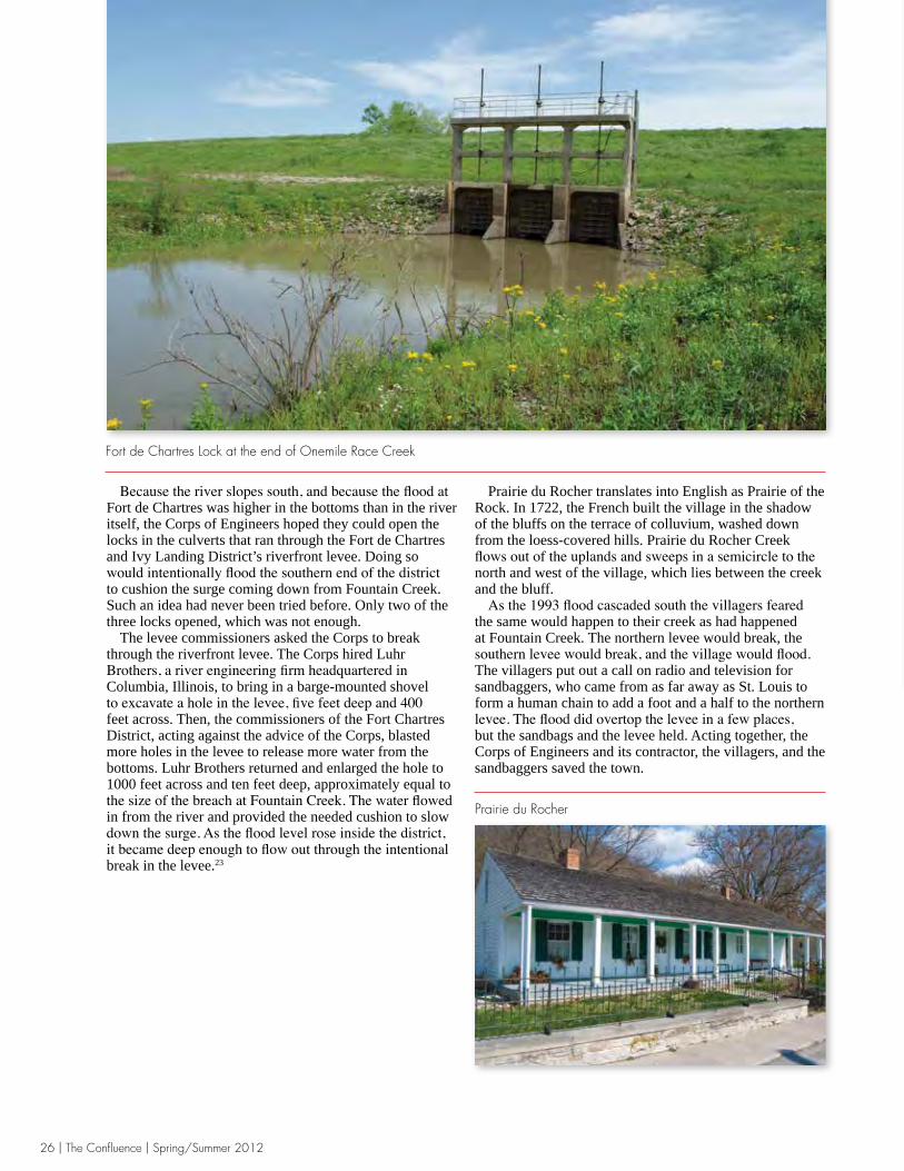
Because the river slopes south, and because the flood at Fort de Chartres was higher in the bottoms than in the river itself, the Corps of Engineers hoped they could open the locks in the culverts that ran through the Fort de Chartres and Ivy Landing District’s riverfront levee. Doing so would intentionally flood the southern end of the district to cushion the surge coming down from Fountain Creek. Such an idea had never been tried before. Only two of the three locks opened, which was not enough. The levee commissioners asked the Corps to break through the riverfront levee. The Corps hired Luhr Brothers, a river engineering firm headquartered in Columbia, Illinois, to bring in a barge-mounted shovel to excavate a hole in the levee, five feet deep and 400 feet across. Then, the commissioners of the Fort Chartres District, acting against the advice of the Corps, blasted more holes in the levee to release more water from the bottoms. Luhr Brothers returned and enlarged the hole to 1000 feet across and ten feet deep, approximately equal to the size of the breach at Fountain Creek. The water flowed in from the river and provided the needed cushion to slow down the surge. As the flood level rose inside the district, it became deep enough to flow out through the intentional break in the levee.23
Prairie du Rocher translates into English as Prairie of the Rock. In 1722, the French built the village in the shadow of the bluffs on the terrace of colluvium, washed down from the loess-covered hills. Prairie du Rocher Creek flows out of the uplands and sweeps in a semicircle to the north and west of the village, which lies between the creek and the bluff. As the 1993 flood cascaded south the villagers feared the same would happen to their creek as had happened at Fountain Creek. The northern levee would break, the southern levee would break, and the village would flood. The villagers put out a call on radio and television for sandbaggers, who came from as far away as St. Louis to form a human chain to add a foot and a half to the northern levee. The flood did overtop the levee in a few places, but the sandbags and the levee held. Acting together, the Corps of Engineers and its contractor, the villagers, and the sandbaggers saved the town.
Fort de Chartres Lock at the end of Onemile Race Creek
Prairie du Rocher

Spring/Summer 2012 | The Confluence | 27
When the 1993 flood breached the Columbia district levee just south of Carr Creek at the very northern edge of the district, it scoured a 95-foot deep hole at the breach, almost to bedrock. It spread out to the north and east, then flowed south and deposited a fan of coarse and fine sand that covered the fields for a mile and a half south of the break. Some of the sand came from the river, some came from the levee itself, but most of it came from the sand-rich deposits of the Cahokia and Henry Formations in the scour hole. The sand fan covered 760 acres to a maximum thickness of eight feet in one small point and a minimum thickness of six inches. About three-quarters of a mile from the break, where the sand was about six inches deep, the force of the flood bent corn stalks and stripped them of their leaves and young ears. In the wake of the flood, American Bottom farmers cleared the sand from their fields and returned it to the scour hole from which it came.24
On September 3, a month after the Columbia Levee broke, the Monroe County Commissioners issued a press release detailing the impact of the flood on the residents of the floodplain: 47,000 acres inundated; 650 houses flooded—350 in Valmeyer, 50 in Fults, and 250 farm houses; 2,600 people were displaced. No one died. The economic losses came to $130 million: $5 million in assessed value, $93 million in land, $15 million in residential buildings, $5 million in farm buildings, $2 million in commercial buildings, $5 million in public buildings, and $5 million in infrastructure.25
A corn field covered in sand washed in by the flood,May 1994
Corn,Stringtown—Janauary 1994

28 | The Confluence | Spring/Summer 2012
Flood waters spread sand across the landscape, cut gullies in the fields, filled the drainage ditches with sediment, bits and pieces of houses, corn stalks, and other debris. Before the end of August, farmers understood that clean up would not come in time to plant winter wheat in September. And they were concerned that the levees would not be repaired in time to plant the corn and soybeans in the spring. In 1963, American Bottom farmer Herbert Mueller planted a cypress grove in a low place on his farm. The cypress thrived, possibly because Mueller planted them right up against a railroad embankment that made drainage
to Long Slash Creek to the south difficult. The flood did not completely drain away from the bottoms until the river fell below flood stage several months later. The following May his fields were still very wet and moist soil plants were growing at the edges.26
At one hundred acres, reduced from five hundred, Moredock Lake, the remnant of an ancient channel of the Mississippi, is still beloved by duck hunters, birders, and anglers. The Flood of 1993 washed rough fish into the lake like Silver carp—that air-born fish that can knock an angler senseless. Gar, drum, buffalo, and suckerfish also replaced the bass, crappie, and bluegill that anglers prize. The Village of Valmeyer hired professional anglers to cull rough fish from the lake. They put in large-mesh nets that capture the big fish and let the smaller valuable fish pass through. The work is done in the winter. Once the rough fish were culled from the lake, the village restocked the lake with valuable fish. Birders have tracked Cattle Egrets from their roosts in Kidd Lake to Moredock Lake. Others have spotted flocks of Pelicans and Snow Geese stopping by on their fall migration. White Ibis, birds normally found along the Atlantic and Gulf coasts, have been seen at Moredock. Avocets, which normally stalk salt and brackish marshes, have stumbled upon Moredock. Forster’s Terns and Black Terns have also been found at the lake.
Mueller’s Cypress—May 1994
Moredock Lake

Spring/Summer 2012 | The Confluence | 29
At one time the Mississippi looped across the Stringtown-Fort de Chartres and Ivy Landing Levee and Drainage District in large meanders, similar to the Moredock Lake meander. When the river changed its regime, it left behind large bottomland lakes. Kidd Lake is the remnant of one; the Chartres Waterfowl Club is another. Drive north along the road at the crown of the riverfront levee. First you will see the big culvert and its three locks, the ones that opened so stubbornly during the Flood of 1993. It is connected to the big Onemile Race Creek Drain. Further up the road you will pass five small culverts, each with one lock, each connected to a smaller drain. In spite of the levee district’s efforts to drain the floodplain for agriculture, internal flooding is a problem when the Mississippi is in full flood and the locks in the several culverts, where the drains meet the riverfront levee, are closed. Water in the drains and creeks spills over onto the fields because there is no pump at the main set of locks.
Before European settlement, Fults Creek, now channelized in two directions to speed floodwater off agricultural land, flowed out of the uplands and refreshed Kidd Lake Marsh. The Fort Chartres and Ivy Landing Drainage and Levee District diverted the creek to the Onemile Race Creek ditch and cut off the flow of water to the marsh. Farmers purchased bits and pieces of Kidd Lake, drained it, and converted it to cropland, which is why when you see it from Fults Hill Prairie, it is broken into squares.
At the end of the twentieth century, the state of Illinois and individual landowners had begun restoring wetlands and forests. By 2000, 7,715 acres of wetlands and 10,025 acres of forest had been restored, much of it in the hard-to-drain Fort Chartres and Ivy Landing Levee District.27
Like Moredock Lake, Kidd Lake is an abandoned channel of the Mississippi that evolved into a bottomland lake. Before European settlement, it hosted a floodplain forest and a slope forest on colluvium between the lake and the bluffs. In 1970, the State of Illinois purchased 226 acres of the original lake, added 218 acres to its holdings in 1988, and created the Kidd Lake Marsh Natural Area. In 1997, a private duck club purchased 200 acres to the west of the natural area. The state and the duck club began restoring 650 acres of the original lake, building low containment levees and pumping in well water to keep it wet. In May 2011, Southwestern Illinois Resource Conservation and Development donated 94.5 acres to the Illinois Department of Natural Resources to be added to Kidd Lake. The funding for the purchase of the land came from the Illinois
Kidd Lake Marsh State Natural Area
The Stringtown-Fort de Chartres and Ivy Landing Levee and Drainage District—June 2011
Fults Creek Diversion Ditch

30 | The Confluence | Spring/Summer 2012
Clean Energy Community Foundation, the Vital Lands Illinois Program within the Grand Victoria Foundation, and The Nature Conservancy. In April 2010, the Rock Island District of the Corps of Engineers made a list of high priority ecosystem restoration projects for the Middle Mississippi, which extends from the Missouri River to the Ohio. While the engineers’ primary focus was on islands and side channels in the river, they also looked at the possibility of incorporating Kidd Lake into a diverse complex that would include Fort Chartres Island and Chute along the river.28
In the spring Kidd Lake is a cacophony of frog calls, males looking for mates: chorus frogs sing, southern leopard frogs cackle, northern spring peepers peep, American toads trill, and bullfrogs go “glu-ub, glu-ub.” Kidd Lake marsh was once home to a variety of wetland birds, some now rare in Illinois. It is an important rest stop for migrating waterfowl and continues to provide critical habitat to amphibians, reptiles, and a diverse range of birds—so diverse that the American Waterfowl
Management Plan considers Kidd Lake one of the most important Illinois wetlands for breeding species. In early spring a profusion of duckweed (Lemnoideae species), each no larger than a baby’s pinky fingernail, starts to dot the surface of the lake. Startled American Coots run across the water before taking off. By summer wading birds—Great Blue Herons, Little Blue Herons, Great Egrets, and shy Sora—pick through the young cattails (Typha species), lotus (Nelumbo nucifere), smartweeds (Polygonum pensuylvanicum), cordgrass (Spartina pectinata), river bulrush (Scirpus fluviatilis), false aster (Boltonia asteroids recognita), and arrowleaf (Polygonium sagittatum). They all hang around through the fall, when Canada Geese, Snow Geese, Blue-Winged Teals, Mallards, Wood Ducks, and Gadwalls descend on their fall migrations. The Great Blues and the Coots can be found during a mild winter, when the Bald Eagles arrive and muskrats build their dome-shaped houses from summer’s cattails, lotus, and bulrush. The Chartres Waterfowl Club is a private duck hunting
Kidd Lake Marsh State Natural Area

Spring/Summer 2012 | The Confluence | 31
area, one of several on the American Bottom. Charlie Frederick, a one-man conservation organization, swears ducks would fly over looking for the natural wetlands that once dotted the landscape before he created duck ponds out of farmland. Like at Kidd Lake Natural Area, Great and Snowy Egrets wade his ponds. So do Great Blue Herons. Pelicans drop by on their spring and fall migrations. The club is reserved for ducks and duck hunters between Thanksgiving and January 20. Frederick welcomes others to the club anytime between January 20 and Thanksgiving. Frederick practices moist soil management at Chartres Waterfowl. He built levees to create duck ponds out of cornfields, where he manipulates the water levels, drawing down the levels in the summer and allowing moist soil plants to grow, food for migrating ducks, recreation for duck hunters. Finally, he is restoring a bottomland forest,
where he has planted pin oak and other hardwoods in fields adjacent to the duck ponds. In the late eighteenth century, Jean Baptiste Barbeau built his house on the bank of Barbeau Creek and under the shadow of the Modoc Rock Shelter. Barbeau Creek flowed out of the uplands, emptied into Marais Geauteau—a lake—and then through The Discharge, which spread out into the swales in the floodplain. Before the Corps of Engineers channelized Prairie du Rocher Creek between levees, it, too, flowed to the river through The Discharge. Even after more than a century of drainage projects on the American Bottom, Barbeau Creek flows to The Discharge, which carries the creek through a culvert in the levee. No lock in the culvert under the levee prevents the Mississippi from backing up and filling The Discharge with water come floodtime. Once through the levee, Barbeau Creek waters a bottomland forest in the batture lands before emptying into the Mississippi. Most of the forests on the American Bottom are limited to the batture lands between the levee and the river. They are treed in cottonwood (Populus deltoids), sycamore (Platanus occidentalis), hackberry (Celtis occidentalis), sweet gum (Liquidambar styracififlua), swamp oak (Quercus bicolor), white walnut (Juglans cinerea), black walnut (Juglans nigra), pecan (Carya illinoinensis), and sugar maple (Acer saccharum). There are, however, patches of forest scattered throughout the bottoms inside the levees, mostly in places, like Herbert Mueller’s cypress grove, that are hard to drain and along the ridges that define the edges of the swales in The Discharge.29
Fort Chartres Duck Club
Barbeau Creek Runs through The Discharge Coulie

32 | The Confluence | Spring/Summer 2012
1 Steven R. Ahler, “Stratigraphy and Radiocarbon Chronology of Modoc Rock Shelter, Illinois,” American Antiquity, Vol. 58, No. 3 (1993); Timothy R. Pauketat, A Tour Guide to the Prehistory and Native Cultures of Southwestern Illinois and the Great St. Louis Area (Springfield: Illinois Humanities Council, Illinois Historic Preservation Agency, 1993), 38-39; Melvin L. Fowler, “Modoc Rock Shelter: An Early Archaic Site in Southern Illinois,” American Antiquity, Vol. 24, No. 3 (1959), 257-70; Conversation with Rose Curten, January 20, 2012.
2 Jesuit Relations, LXIX, “Letter from Father Vivier, Missionary among the Illinois, June 8, 1750,” 145; Jesuit Relations, LXIX, “Letter from Father Vivier of the Society of Jesus, to a Father of the same society,” November 17, 1750, 218.
3 Middle Mississippi River Partnership, The Middle Mississippi River Regional Corridor Reach Reports, American Bottom Ecoregion 1: Middle Mississippi River, 2009, ER1-1-7.
4 Bonnie W. Styles, Steven R. Ahler, Melvin L. Fowler, “Modoc Rock Shelter Revisited,” in James L. Phillips and James A. Brown, eds., Archaic Hunters and Gatherers in the American Midwest (Walnut Creek, California: Left Coast Press, 2009), 267-69; R. Bruce McMillan, “Two Images in Time: The Bluff at Barbeau Creek,” Illinois Periodicals Online Project, 2006, http://www.lib.niu.edu/2006/ih050606.html; Conversation with Rose Curten, January 20, 2012.
5 John E. Kelly, “The Emergence of Mississippian Culture in the American Bottom Region,” in Bruce Smith, ed., The Mississippian Emergence (Tuscaloosa: University of Alabama Press, 1990), 113-52; Thomas J.Riley, “Mississippian Agronomic Practices,” in David J. Hally, ed., Ocmulgee Archaeology, 1936-1986 (Champaign-Urbana: University of Illinois Press, 2009), 99; Melvin L. Fowler, “Middle Mississippian Agricultural Fields,” American Antiquity, Vol. 34, No.4 (October 1969), 365-75; John E. Kelly, “The Pulcher Site: An Archaeological and Historical Overview,” Illinois Archaeology, Vol. 5, Nos. 1 and 2, (1993), 434-51; Thomas J.Riley and Chaksana Said, “Fly ash analysis supports emergent Mississippian agricultural features at the Lunsfore-Pulcher Site (11-S-40) in the American Bottom, Illinois,” The Plains Anthropologist, Vol. 38, No. 143 (May 1993), 177-86; Hugh Price, Wetlands of the American Midwest (Chicago: University of Chicago Press, 1997), 85-88.
6 James Edward Davis, Frontier Illinois (Bloomington: University of Indiana Press, 2000), 44; Carl J. Ekberg, French Roots in the Illinois Country: The Mississippi Frontier in Colonial Times (Champaign-Urbana: University of Illinois Press, 2000), 182.
7 Pierre Margry, Decouvertes et Establissments des Francais (Paris, 1879), Vol V., 488-89.
8 Abraham Lincoln, “Opinion Concerning Swamp Lands in Bureau County, Illinois, January 31, 1859,”
in Collected Works of Abraham Lincoln, edited by Roy P. Basler, Dolores Pratt, and Lloyd A. Dunlap (New Brunswick, New Jersey: Rutgers University Press), 1953, 352-53.
9 Devera, Oakville Quadrangle, August 2003.10 Conversation with Delbert Wittenauer, January 12, 2012;
H.B. Willman, et al., Handbook of Illinios Stratigraphy, Bulletin 95, Illinois State Geological Survey (Urbana: Department of Registration and Education, State of Illinois, 1975), 226, 230-31; Laws of the State of Illinois, Passed by the Twenty-first General Assembly (Springfield: Bailache and Baker, Printers, 1859), 110.
11 Jesse White, Illinois Secretary of State and State Archivist, Illinois State Archives, “Drainage Districts,” http://www.cyberdriveillinois.com/departments/archives/irad/drainage.html.
12 G. W. Pickels and F. B. Leonard, Jr., Engineering and Legal Aspects of Land Drainage in Illinois, Division of the State Geological Survey, Bulletin No. 42, State of Illinois (Urbana: State of Illinois Department of Registration and Education, 1921), 20-23, 40, 43; Conversation with Doris and Bob Ripplemeyer, January 12, 2012.
13 James M. Wright, The Nation’s Responses to Flood Disasters: A Historical Account (Madison: The Association of State Floodplain Managers, April 2000), 9-12; Southern Illinois Flood Prevention District Council, http://www.floodpreventiondistrict.org/; Ann Vileisis, Discovering the Unknown Landscape (Washington, D.C.: Island Press, 1997), 174; Nancy S. Philippi, “Revisiting flood control in light of the 1993 Mississippi flood event,” The Wetlands Initiative: http://www.wetlands-initiative.org/pub/revisiting.html#1993; U.S. Army Corps of Engineers, Legislation Pertinent to the Water Resources Program of the Corps of Engineers, EP 1165-2-1, 15 February 1996, B-8; U.S. Army Corps of Engineers, “The Evolution of Federal Flood County Policy,” http://www.usace.army.mil/inet/usace-docs/eng-pamphlets/ep870-1013/c-4.pdf, 29-30.
14 Raymond Rippelmeyer in Helen Ragland Klein, ed., Arrowheads to Aerojets (Waterloo, Illinois: Monroe County Commissioners, 1967), 96-97.
15 Combined History of Randolph, Monroe, and Perry Counties, Illinois (Philadelphia: J. L. McDonough & Co., 1883), 333-35; William A. Bruette, “St. Louis Notes,” Forest and Stream, Vol. 50 (March 19, 1898), 228.
16 John Thomas Scharf, History of St. Louis City and County: From the Earliest Periods to the Present Day, Vol. II (Philadelphia: Louis H. Everts & Co., 1883), 1061.
17 Janet Flynn, “Monroe County, Illinois, A Short Historical Sketch,” http://monroe.ilgenweb.net/history_mc.html; Combined History of Randolph, Monroe, and Perry Counties Illinois, 383; William Herbert Bixby, U.S. Army Corps of Engineers, Report by a special beard of engineers on survey of River from St. Louis,
N O T E S

Spring/Summer 2012 | The Confluence | 33
Mo., to its mouth (Washington, D.C.: U.S. Government Printing Office, 1909), 518; John Reynolds, Pioneer History of Illinois (Belleville, Illinois: N.A. Randall, 1852), 91; H. C. Frankenfield, The Floods of the Spring of 1903 in the Mississippi Watershed (Washington, D.C.: Weather Bureau, 1904), 27; Scharf, History of St. Louis City and County, 1061; Charles J. Allen in Annual Report of the Chief of Engineers to the Secretary of War for the Year 1873 (Washington, D.C.: Government Printing Office, 1873), 472.
18 F. Terry Norris, “ Where Did the Village Go?” in Andrew Hurley, ed., Common Fields, An Environmental History of St. Louis (St. Louis: Missouri Historical Society Press, 1997), 73-89; J. H. Burnham, “Destruction of Kaskaskia by the Mississippi River,” in Transactions of the Illinois State Historical Society for the Year 1914 (Springfield: Illinois Historical Society, 1914), 95-112.
19 M. J. Chrzastowski, M. M. Killey, R. A. Bauer, P. B. DuMontelle, A. L. Erdmenn, B. L. Herzog, J. M. Masters, and L. R. Smith, The Great Flood of 1993 (Champaign: Illinois Geological Survey, Special Report 2, March 1994), 27; W. T. Frankie, D. A. Grimley, R. J. Jacobson, R. D. Norby, S. V. Panno, and M. A. Phillips, Guide to the Geology of the Columbia and Waterloo Area, Monroe County, Illinois, Field Trip Guidebook, 1997a (Champaign: Illinois State Geological Survey, April 19, 1997), 45-51.
20 U.S. Army Corps of Engineers, “Geodetic, Tidal, and Hydraulic Reference Datums Used to Define Project Grades on Civil Works Projects,” EM 1110-2-6056, December 31, 2010, 2-17-19, http://140.194.76.129/publications/eng-manuals/em1110-2-6056/sections/c-02.pdf.
21 National Weather Service Weather Forecast Office, St. Louis, Mo., “The Great Flood of 1993,” http://www.crh.noaa.gov/lsx/?n=1993_flood; St. Louis District, U.S. Army Corps of Engineers, Esprit, Vol. 42, No. 6 (Summer 2003), 18; http://www.mvs.usace.army.mil/pa/esprit/2003/93%20flood%20Esprit.pdf; Description of Low Water Reference Plane and height of the levees based on a graphic supplied by Rodney Linker, Luhr Brothers, January 31, 2012.
22 M. J. Chrzastowski, et al., 18-21, 27; W. T. Frankie, et al., Guide to the Geology of the Columbia and Waterloo Area, 45-51; Rodney Linker and the Luhr Brothers, emails, October 20, 2010, January 31, 2012.
23 James T. Lovelace and Claude N. Strauser, “Protecting Society from Flood Damage: A Case Study from the 1993 Upper Mississippi River Flood,” U.S. Army Corp of Engineers, St. Louis District, Water Control Operations, http://mvs-wc.mvs.usace.army.mil/papers/93flood/93flood.html; M. J. Chrzastkowski, et al., 18-21; Telephone Conversation with Claude Strauser, Retired Potomologist, U.S. Army Corps of Engineers, January 27, 2012, Linker email, January 31, 2012.
24 M. J. Chrzastkowski, et al. Guide to the Geology of the Columbia and Waterloo Area, 33-34; Frankie, et al., Guide to the Geology of the Columbia and Waterloo
Area, 51; Joseph A. Devera, Surficial Geology of the Oakville Quadrangle, Monroe County, Illinois and St. Louis County, Missouri (Champaign: Illinois Geological Survey, August 2003), http://www.isgs.uiuc.edu/maps-data-pub/isgs-quads/o/pdf-files/oakville-sg.pdf.
25 Ripplemeyer, Ray, Press Release, September 3, 1993, in John Conrad, The Flood Disaster of 1993, Report to the Monroe County Commissioners, December 30, 1993.
26 George Gunset, “First Flood Aid Checks Arrive,” Chicago Tribune, August 20, 1993, http://articles.chicagotribune.com/1993-08-20/news/9308200087_1_flood-crop-agricultural-stabilization.
27 Illinois State Geological Survey, Surficial Geology of Columbia Quadrangle Map, St. Clair and Monroe Counties, Illinois, IS THIS A DIFFERENT SOURCE FROM THAT CITED IN N. 24?http://www.isgs.uiuc.edu/maps-data-pub/isgs-quads/c/pdf-files/columbia-sg.pdf; American Bottom Ecosystem Partnership: Issues and Opportunities Report, 2001-2, 8, http://www.swircd.org/pdf/ambot.pdf.
28 The Land Conservancy, “Places We’ve Protected,” Southwestern Illinois Resource Conservation and Development http://www.swircd.org/Places_Weve_Protected.html; Illinois Department of Natural Resources, Fults Hill Prairie and Kidd Lake Marsh State Natural Areas http://dnr.state.il.us/lands/landmgt/parks/r4/fhp.htm; Southwestern Illinois Resource Conservation and Development, Commonfields, Summer 2011, 4 http://www.swircd.org/11%20Summer.01.pdf; Rock Island District, U.S. Army Corps of Engineers, “Unimpounded River, Reaches 9-10, Middle Mississippi River,” http://www.mvr.usace.army.mil/EMP/Documents/Appendix%20C-1.pdf.
29 Steven R Ahler, “Stratigraphy and Radiocarbon Chronology of Modoc Rock Shelter, Illinois,” American Antiquity, Vol. 58, No. 3 (July 1, 1993); Conversation with Rose Curten, Modoc, Illinois, January 20, 2012.