Board of Geological Survey - Washingtonfile.dnr.wa.gov/publications/ger_ar1915-17_brd_of_geol.pdf6...
32
The Biennial Report OF THE Board of Geological Survey OF THE State of Washington · FOR THE TERM 1915-1917 OLYA!l'IA, WA.SB. FB.A.NK M. LAMBORN PUBLIC PRINTER 1917
Transcript of Board of Geological Survey - Washingtonfile.dnr.wa.gov/publications/ger_ar1915-17_brd_of_geol.pdf6...
The Biennial Report
OF THE
Board of Geological Survey
OF THE
State of Washington
·FOR THE TERM 1915-1917
OLYA!l'IA, WA.SB.
FB.A.NK M. LAMBORN ~ PUBLIC PRINTER
1917

LETTER OF TRANSMITTAL.
To the Legislature of the State of W ashmgton:
The Board of Geological Survey transmits herewith its
biennial report for the term 1915-17, as required by statute.
Respectfully submitted,
ERNEST LISTER, Presi<lent; LOUIS F. HART,
EDWARD MEATH, Secretary; HENRY SuzzALLo, ERNEST o. HOLLAND.
Olympia, December ~8, 1916.
TABLE OF CONTENTS.
GENERAL PU1U'OSE OF SURVEYS: Page Topographic Surveys .. . . . . . . . . . . . . . . . . . . . . . . . . . . . . . . . . . . . . . . . 5 Hydrometrlc Surveys . . . . . . . . . . . . . . . . . . . . . . . . . . . . . . . . . . . . . . . . 6
Geological Surveys . . . . . . . . . . . . . . . . . . . . . . . . . . . . . . . . . . . . . . . . . . 8
PRINCIPAL FEATURES OF STATE LAW PROVIDING FOR SURVEYS........ 9
REPORT FOR 1915-1917: Organization .............................. .. .........••. , . . . 11 Topographic Surveys . . . . . . . . . . . . . . . . . . . . . . . . . . . . . . . . . . . . . . . . 11 Hdyrometrlc Surveys . . . . . . . . . . . . . . . . . . . . . . . . . . . . . . . . . . . . . . . . 12
Gaging Stations . . . . . . . . . . . . . . . . . . . . . . . . . . . . . . . . . . . . . . . . . 13 Cascade Power Reports. . . . . . . . .. . . . . . .. . . . . .. . .. . . . . . . . .. . 17
Geological Surveys . . . . . . . . . . . . . . . . . . . . . . . . . . . . . . . . . . . . . . . . . . 18 Mineral Resources . . . . . . . . . . . . . . . . . . . . . . . . . . . . . . . . . . . . . . . 18 Office Work . . . . . . . . . . . . . . . . . . . . . . . . . . . . . . . . . . . . . . . . . . . . . . 21
FINANCIAL REPORT . . . • . . • • • . . • . • . • • • . . • • . • • • . • • • • • • • • • • • . • • • . . . . 21 REOOllME?,"DATIONS • • • • • • • . • . • • . . • • . . • • • . . • • . • . • • . . • • . . • . . • • • • . • . 22
Appropriations Requested . . . . . . . . . . . . . . . . . . . . . . . . . . . . . . . . . . . . 22 Topographic Surveys . . . . . . . . . . . . . . . . . . . . . . . . . . . . . . . . . . . . . . . . 22 Hydrometrlc Surveys . . . . . . . . . . • . . . . . . . . . . . . . . . . . . . . . . . . . . . . . 22 Geological Surveys . . . . . . . . . . . . . . . . . . . . . . . . . . . . . . . . . . . . . . . . . . 23
Uncompleted Reports . . . . . . . . . . . . . . . . . . . . . . . . . . . . . . . . . . . . . 23 Soil Surveys . . . . . . . . . . . . . . . . . . . . . . . . . . . . . . . . . . . . . . . . . . . . . 23 Road Materials . . . . . . . . . . . . . . . . . . . . . . . . . . . . . . . . . . . . . . . . . . 24 Surveys of Metal Mining Districts......................... 24 Report on Mineral Industries... .... ...... ................. 25 Topographical Map . . . . . . . . . . . . . . . . . . . . . . . . . . . . . . . . . . . . . . . 25 Geological Map . . . . . . . . . . . . . . . . . . . . . . . . . . . . . . . . . . . . . . . . . . . 25
PUBLICATIONS • • • • • • • • • • • • • • • • • • • • • • • • • • • • • • • • • • • • • • • • • • • • • • • • • • • 27


BIENNIAL REPORT OF THE BOARD OF GEOLOGICAL SURVEY
GENERAL PURPOSES OF SURVEYS.
TOPOGRAPmc SURVEYS.
The Topographic Map.-A topographic map is designed to represent the form and slope of the surface of the land and the elevation of all points above sea level. The positions of streams, lakes and ponds, public and private roads, towns and raih-oads, arc shown in their correct relative positions. The map indicates boundaries of counties and the position of section lines wherever there have been land surveys. In the making of the necessary surveys for such maps permanent marks, consisting of iron posts, copper bolts or tablets, are set at frequent intervals to mark the exact elevation above sea level to serve as datum points for further spirit level work, for engineering .investigation, and for such public works as canals, water supply, railway and other public or private surveys.
The topographic map is made with such accuracy and in such detail that it is useful to almost every citizen. In a new state that is inviting immigration, the map is valuable in order to show the location of desirable farm lands and the general character of the country. From it the positions of streams and lakes may be seen and the possibilities of these for purposes of water power or irrigation may be largely determined. The topographic map facilitates the construction of railroads and wagon roads, since upon it available routes and grades may be laid out without the preliminary surveys ordinarily necessary for improvements of this kind. In our public schools such a map is indispensable in that it places before the children truthful maps of our commonwealth, instead of those that are glaringly inaccurate.
In the making of topographic maps the areas selected for survey are defined by lines of latitude and longitude and are

6 Board of Geological Survey
called quadrangles. Each quadrangle, and the topographic map which represents its features, is designated by the name of the most prominent place or topographic feature included within it. The scale generally used in map construction is about two miles to the inch, and on this scale the area embraced in a quadrangle is about eight hundred square miles. In Washington, the topographic map when completed will comprise, in round numbers, ninety sheets, complete and fractional, of which about thirty-eight have already been surveyed.
HYDROMETRIC SURVEYS.
Hydrometric surveys furnish a basis for determining the water resources of the state. They are essential to indicate the supply of water suitable for domestic and industrial purposes, for comprehensive development of power and irrigation projects, for navigation and flood prevention, and for wise and equitable sanitary regulation. The water supply is of more importance to the life and pursuits of the people than any other natural resource, as the health and economic development of every community are directly dependent upon the character and volume of the available supply.
Our water resources are unlike the other mineral resources in that they are continually existent. Our coal beds and mineral lodes are exhausted when mined and placed upon the market, but the water supply is constantly renewed. T herefore, failure to put water into beneficial use is an economic loss, for the energy and utility does not serve the needs of civilization effectively prior to hydraulic development.
When estimates and designs for hydraulic development are made, all essential physical details, except the stream flow, can be determined within a relatively short time. The amount of water available and its seasonal distribution can be ascertained only by a study of stream flow records extending over a series of years. Many irrigation and power projects have failed on account of being placed in operation without an adequate knowledge of stream flow. Others designed upon the basis of short time records have levied an enormous toll upon the public

The Bimnial Report 7
through high rates made necessary by unexpected seasonal variation in flow. The run-off for streams in Washington is extremely irregular, especially in respect to the minimum flow which is the most important in considering the operation of any project. For instance, the low water period in August and September of 1915 was much lower than any other on record, likewise the lowest period in 1916 occurred in October and November, when the flow was nearly as low as in August and September, 1915, but was later in the season than shown by any previous records. Aside from the design and operation of irrigation and power projects, stream flow records are vitally essential in considering means of preventing damage from floods. Occasionally "Chinook" winds accompanied by heavy rains melt the snow in the mountains, causing disastrous floods in the lowlands. The last serious flood of trus kind occurred in 1906. Unfortunately few records of stream flow were being kept then, so that ,,ery meager information is available for designing protective works, although more complete reco1·ds on streams flooded less seriously in 1909 are very useful.
Hydrometric surveys cover two fields of investigation, the surface supply and the underground supply. T he surface supply furnishes by far the greatest volume of water and is readily accessible in the various rivers and creeks. Gaging stations are maintained along the principal streams of the state for determining the daily flow throughout a series of years. Daily records are published and are used extensively in designing hydraulic works of all kinds. Probably the greatest ultimate benefit derived from the streams in the state will be brought about by hydro-electric development. Washington r anks first among the states in t he union in l'espect to estimated potential water-power.•
• A report of the CommlssJoner of Corporations for March 14, 1912, pp. 1515-56, summarizes the potentia l water pow()r In cacb state. Washington Js credited with a "minimum" potential water power of more than a mllUon horsepower greater than for any other state. The three states having the greatest "mlDJ· mum" potential water power are as follows: Washington, 4,932,000 horsepower ; California, 3,424,000 horsepower: and Oregon, 3,148,000 horsepower.
8 Board of Geological Survey
The possibilities for water power development are being investigated as rapidly as possible. The records of flow indicate water supply. River profiles or level lines along the principal power streams indicate the fall, dam sites, reservoir sites, and other pertinent data. An analysis of the information is being made in a series of seven reports on the water powers of the Cascade Range, three of which are published and a fourth in preparation. These reports summarize the most r eliable information obtainable and will greatly encourage hydro-electric enterprise.
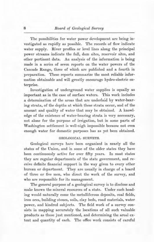
Investigation of underground water supplies is equally as important as in the case of surface waters. This work includes a determination of the areas that are underlaid by water-bearing strat a, of the depths at which these strata occur, and of the amount and quality of water that may be obtained. A knowledge of the existence of water-bearing strata is very necessary, not alone for the purpose of irrigation, but in some parts of Washington settlement is well-nigh impossible because not even enough water for domestic purposes has as yet been obtained.
GEOLOGICAL SURVEYS.
Geological surveys have been organized m nearly all the states of the Union, and in some of the older states they have been continuously active for over fifty years. In most states they are regular departments of the state government, and receive definite financial support in the way given to every other bureau or department. They are usually in charge of a board of three or five men, who direct the work of the survey, and w.ho are responsible for its management.
The general purpose of a geological survey is to disclose and make known the mineral resources of a state. Under such head~ ing would naturally come the metalliferous deposits, coal fields, iron ores, building stones, soils, clay beds, road materials, water power, and kindred subj ects. The field work of a survey consists in mapping accurately the locations of all such valuable products as those just mentioned, and determining the area] extent and quantity of each. The office work consist s of careful

The Biennial Report 9
tests and analyses of all samples collected in the field, and the p reparation of reports which describe fully the mineral resources under investigation. The reports and maps when published a re valuable alike to the citizens of the state and to outside capitalists and investors. Surveys examine and test those minerals, ores and rocks that a1·e but little known and determine whether or not they are of economic value. They also suggest ways of p reventing waste in mining operations, and assist in all ways to conserve the natural resources. Surveys are potent £actors in making available valuable information regarding the mineral resources of the state, which knowledge may be utilized by the poorest citizen as well as the wealthiest corporation.
PRINCIPAL FEATURES OF STATE LAWS PROVIDING FOR SURVEYS.
The law establishing a state geological survey was passed by the legislature at the session of 1901. As set forth in the various sections of the law, the principal objects of the measure are as follows : An examination of the economic products of the state, such as gold, silver, copper, lead, and iron ores, as well as building stones, clays, coal, and all mineral substances of value; an examination of the soils, road-building material, water supplies, artesian wells, water power, etc. ; an examination of the physical features of the state with reference to their practical bearing upon the occupations of the people; the preparation of special geographic and economic maps to illustrate the resources of the state; and the publication from time to time of the result s of the work of the survey in reports and bulletins, and the dissemination of these among the people.
At the session of 1908 the legislature amended the above law, by providing for cooperative work between the federal and the state bureaus engaged in geological survey work. The amendment authorized the state board of geological survey to make provisions for topographic, geologic, and hydrometric surveys of the state, in cooperation with the United States geological survey, in such manner as would be of the greatest benefit to the agricultural, industrial and geological requirements of the

10 Board of Geological Survey
state. The amendment carried a proviso that the director of the United States Geological Survey should agree to expend on the part of the United States upon such surveys a sum equal to that expended by the state.
At the session of the legislature for 1909 the work of the state geological survey was provided for by a law having these provisions :
SeCT10:-. 1. In order to complete the topographical map of the State of Washington, and for the purpose of making more extensive stream measurements, and otherwise Investigating and determining the water supply of the state, there is hereby appropriated the sum of thirty thousand dollars ($30,000), for cooperation with those branches of the United States Geological Survey engaged In this work. This appropriation, however, shall be contingent upon, and not become available unless the United States government apportion an equal amount to be expended for similar purposes within the state. The board of geological survey is hereby authorized and directed to enter into such agreements with the director of the United States Geological Survey as will insure that the said surveys and investigations be carried on In the most economical manner, and that the maps and data be available for the use of the public as quickly as possible.
Seo. 2. In order to enable the board of geological survey to carry on Investigations authorized by law, there Is hereby appropriated the sum of twenty thousand dollars ($20,000) for the use of said board in the geological and other investigations provided for in chapter 165 of the Session Laws of the State of Washington for 1901, and as amended In chapter 167 of the Session Laws of 1903.
SEO. 3. In order to carry out the purposes of this act, all persons employed hereunder are authorized to enter and cross all lands within the state: Proviaect, That in so doing no damage is done to private property.
Sec. 4. The sum of fifty thousand dollars ($60,000) herein approproprlated for the purposes specified in this act shall be available in the following manner: One-half during the first twelve months after this act takes etrect, and the unexpended balance during the second twelve months after this act takes effect.

The Biennial Report 11
REPORT FOR 1915-17.
ORGANIZATION.
The State Board of Geological Survey consists of the following members: Governor Ernest Lister, President; Lieutenant Governor Louis F. Hart; State Treasurer Edward Meath, Secretary; President Henry Suzzallo, of the State University; and President Ernest 0. Holland, of the State College. The State Geologist is Professor Henry Landes, who has his office at University Station, Seattle. In cooperation with the United States Geological Survey the Director of that organization is 1·epresented by Thomas G. Gerdine, Geographer in Charge, Northwestern Division; and Glen L. Parker, 406 Federal Building, Tacoma, District Engineer.
TOPOGRAPHIC SURVEYS.
The accompanying progress map indicates the location of the quadrangles surveyed during this biennimn, as well as from 1909 to 1915. In selecting quadrangles for survey it has been the policy of the board to choose those areas where the demand for the maps is very great and where they a1·e most likely to be used to advantage.
Since the last biennial report was made the foil owing topographic sheets have been engraved and are now ready for use: Arlington, Chehalis, Coyote Rapids (formerly called the Haven sheet), Hoquiam, Ocosta, and Wenatchee. The following topographic sheets are in the engravers' hands and will soon be ready for distribution : Malaga, Pasco, and Priest Rapids ( formerly called the Mitchell sheet).
During the field season of 1915 the topographic mapping was done on the Prosser and W a.Hula quadrangles. Upon these maps the office work has been completed and they are now ready £or the engraver. The field season of 1916 was spent on the Wall a Walla and Connell quadrangles, and these areas were completed. The £our quadrangles j ust mentioned were chosen for topographic mapping in order to render assistance to irrigation projects which will be necessary in order to utilize large portions of the arid region. The Connell quadrangle '!as sur-

Board of Geological Survey
veyed in order to render assistance to the dry farming experiment station of the State College which has recently been es
tablished at Lind. Copies of all engraved topographic maps may be purchased
of the United States Geological Survey, Washington, D. C., at ten cents each, or at six cents each in lots of one hundred or more.
HYDROMETRIC SURVEYS.
The water resources of the state have been investigated jointly by the federal and state surveys, each party contributing equal sums. The work is directed from a district office of the federal Survey, located in the Federal Building at Tacoma. In addition the federal Survey maintains gaging stations on Indian reserves, the cost of which is borne by the United States Office of Indian Affairs. It also cooperates with the United States Reclamation Service, and the United States Forest Service in collecting and publishing stream ftow data. T he funds for carrying on stream gaging work are not sufficient to meet the demand for such work, so that power companies, ir1-jgation districts, cities, and individuals have contributed services of employees, instruments, material, equipment, and other help. The cost of hydrometric work carried on in the state during the present biennium is shown in the following table, the value of all services and other assistance rendered by cooperating parties being estimated when not known definitely :
ESTIMATED COST OF WATER RESOURCES INVESTIGATIONS IN THE STATE FOR THE BIENNIUM: ENDING MARCH 31, 1917.
Washington Geological Survey . . . . . . . . . . . . . . . . . . . . . . . . . . . . . $12,000 United States Geological Survey, gaging streams and
power reports . . . . . . . . . . . . . . . . . . . . . . . . . . . . . . . . . $12,000 United States Geological Survey, publishing water
supply papers . . . . . . . . . . . . . . . . . . . . . . . . . . . . . . . . 13,730 United States Geological Survey, ground water in-
vestigations in Quincy Valley ..... . . . . ... . . .. . . United States Reclamation Service (approximate) .. United States Office of Indian Afllairs . . . .......... . United States Forest Service . . .. .. .. .... ........ .. District office rent furnished free of charge in the
Federal Building at Tacoma ... . . . ... ... . .. ... .
1,650 7,000 6,700 1,060
1,440
Total Federal ... .. ... . .. ... ... . .. ... .. .. . ... . .... ... . Power companies, irrigation districts, cities and individua ls
Grand Total
43,580 '1,600
$63,180

The Biennial Report 13
Cooperation between the British Columbia Hydrometric Survey and the United States Geological Survey was instituted during the biennium. It consists of a plan to maintain jointly gaging stations on all important streams at or near the international boundary between Washington and British Columbia.
At present two such stations are being maintained; one on Clark Fork at Metaline Falls, Washington, and one on Columbia River at Trail, British Columbia. It is hoped that the work can be e.."Ctended to cover Kettle, Okanogan, Similkameen, and Skagit rivers.
The chief objects of hydrometric surveys are to obtain accurate information regarding the amount of water that could be depended upon for irrigation and for power purposes. All of the water that can be secured by storage that is tributary to arid Washington will soon be needed for irrigation. The rapid industrfal development of Western Washington demands the continued utilization of the available water power. The detailed investigations have been along two lines, viz. : establishment and maintenance of gaging stations, and a series of reports summarizing the power possibilities of the Cascade Range.
Gagitng Stations.-As shown on the progress map, gaging stations have been maintained upon all of the principal streams of the state. Measurements of fiow are frequently made, and daily records indicating height of water on substantially set gages are kept by local observers or by means of several types of water stage registers, which record the height of water on record sheets by clock driven mechanism. The measurements and gage heights make possible an estimate of the average amount of water flowing each day during the year. The water contributed by any stream varies considerably from day to day, season to season, and year to year, so that records for a series of years are necessary for properly designing hydraulic works. The records are particularly important during low water periods which occur on some streams in the early fall and on others in mid-winter. There are 90 gaging stations in operation at the close of the biennium, 34 of which are equipped with automatic water stage recording instruments.

14 BoarclJ of Geological Survey
The measurements, computed daily discharge, and summary of results are published annually by the United States Geological Survey in water supply papers. A sample of the data published for each station is given below for Skagit River at Sedro Woolley during the year ending September SO, 1916:
SKAGIT R IVER NEAR SEDRO WOOLLEY, WASH.
Location.-In NWl,4, Sec. 36, T. 35 N., R. 4 E., at Northern P acific Railway bridge, three-fourths mile below intake of Beatty's slough, l :Yz miles south of Sedro Woolley in Skagit County, ~l miles above mouth, and 3~ miles below Baker River. Elevation at low water, about ~5 feet.
Dramage Area.-~,980 square miles; measured on General Land Office map.
Records Availa.ble._-May 1, 1908, to September SO, 1916.
Gage.-Vertical staff on cribbing 100 feet above draw-span pier of Northern P acific Railway bridge. Datum, extreme low water in Puget Sound. Temporary gage used when stage was below 37 feet; installed September ~5, 1915, on downsteam side of group of piles, 50 feet above third concrete pier ( from left bank) of railway bridge. Gage read by E. J. Woods.
Discharge Measurements.-Made from highway bridge onethird mile above gage, Bea.tty's slough measured from highway bridge.
Channel and Control.-Gravel; shifts at high stages. Banks do not overflow except during extreme floods.
Extremes of Discharge.-Maximum stage recorded during the year, 46.5 feet at S p. m. June 18 ( discharge, 63,800 second-feet) ; minimum stage recorded, S~.S feet at 7 a. m. October 10-11 (discharge, i,740 second-feet).
1908-1916: Maximum stage recorded, 56.1 feet November 80, 1909 (discharge, 96,100 second-feet); minimum stage recorded, S!2.8 feet September ~9-SO and October 10-11, 1915 ( discharge, ~,740 second-feet).
lce.-Stage-discharge relation seldom affected by ice.

The Biennial Report 15
Diversion.-Beatty's slough carries from 1.5 per cent. of total flow at low stages to 8 per cent at high stages. Amount determined each visit and added to flow measured in river proper.
Regulation.-None.
Accuracy.-Stage-discharge relation changed during high water in June. Rating curve used before June 18 well defined between 3,500 and 18,000 second-feet, fairly well defined above and below; curve used after June 18 fairly well defined above 6,000 second-feet and poorly defined below. Gage read to half tenths daily; in addition crest gage heights observed or estimated. Practically no diurnal fluctuation. Results good except for a short interval in January and in February when they are only fair, due to ice.

16 Board of Geological Survey
DISCHARGE MEASUREM:E1''TS OF SKAGI'l' RIVER NEAR SEDRO WOOLLEY, WASH., DURING TllE YEAB ENDING SEPTEMBER 30, 1916.
Date
Dec. 12 Dec. 13 June 2'2 Jone 28 Sept. 27
Made By-
J. T. Hartson ................................. . J. T. Hartson ......... .............•...... . . ... O. O. Brown .................................. . O. O. Brown ............. ... ...... ........ .... . J. E. Stewart ................................. .
GAGE HEIGHT (a) Die-
Old Teml)Oran charge Gage Gare
Feet
M.tO 85.SS t().00 ,z.95 84.97
Feet
&l.85 35.80
~~ 85.(9
Soo.-Ft.
15,500 12,800 31,800 48,800 10,000
(a) Obaerver's readings below 37 feet were taken trom temporary gaae; above 37 feet trom old gage.
(b) Temporary ga&e submereed.
DAILY DISCHARGE, ~ SECOND-FEET, OF SKAGIT RIVEi!. N'EAR SEDRO WOOLLEY, WASH., FOR THE YEAR ENDING S.EPl'EMBER 30, 1916.
Day Oct. Nov. Dec. Jan. Feb. Mar. Apr. May Jone July Aug. Sept.
1 ... 2 ••• 3 . .•
*··· 5 .•• 6 ... 7 ••• 8 ••• 9 •••
10 . . . u .. . 12 ••• 1.3 ••• 14... 15 .. . 16 . . . 17 •• . 18 •.• 19 ... 20 .•. 21 .. . 22 .. . 23 . •. u ... 25 ••• 216 ••• '1:1 ••• 28 . .• 29 . . . 80 . . . 31 •..
18,700 13,000 14,100 15,000 13,700 11.100 10,300 9,650
10,BOO 9,010 8,080 7,780 7,780 7,780 7,180 7,180 7,480 7,480 1,480 7,180 7,180 7,180 7,780 7,180 6,800 7,780
12,000 8,080 6,000
NOTE.-Stage-dlecbarge relation serlotlBIY a1fecud by Ice gorge on&-baU mile below ra&e Jan. 17-21, dlscbarre lntemolated. Ga&e ool(bta doubtful on account of Ice at rage Feb. $-7, dlscbarre Interpolated.
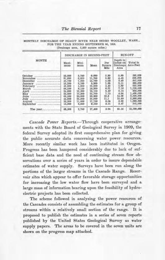
The Biewnial Report 17
MONTHLY DIS0RAR8E OF SKAGIT RIVER NEAl!I SEDRO WOOLLEY, WASH., FOR THE YEAR ENDING SEPTEMllER 80, 1916.
(Drainage area, 2,930 square miles.)
DIS01IARGE IN SECOND-FEET RUN-OFF
MONTH Maxi- MlnJ-
Depth ln Per Inches on Total In
mum mum Mean Square Drainage Acr&-Foot lllle Area ---------•·--------------- •·---
October . . . . . . . . . . . . . . . . . . . . . 88,800 November . . . . . . . . . . . . . . . . . .. 31,900 l)e()j)mber . . . . . . . . . . . . . . . . . . . 46,700 January . . . . . . . . . .. . . .. . .. . . 18,200 February . . . . . . . . . . . . . . . . . . • 48,800 March . . . . . . . . . . . . . . . . . . . . . . 1'18,200 APrU • .• . ... .•..•• .•.. .. •. .. . 24,800 May ....................... . . 33,800 Jane . . . . .. . . . . . . . . . .. . . . . .. . 63,300 July . .. . . . . .. . . .. .. . . .. .. . . .. 44,000 August . • . . . .. . • .. . . .. .. • . .. 25,SOO September . . . . . .. . .. . .. .. . . .. 16,900
The year........... . ... 63,800
~.740 6,030 7,220 S,190 4, 660 8,150
12,000 16,800 20,000 22,000 11, 000 6,020
9,680 11,700 13,700
6,360 16,000 18,200 16,100 22,700 86,900 82,600 17,700 9,120
2,740 17,400
3.80 3.99 4.68 1.83 5.46 6.21. 6.49 7.75
12.6 11.1 6.M s.u 5.9,l
S.80 4.45 5.40 2.11 5.89 7.16 6.12 8.94 u.oo
12.80 6.96 3.47
596,000 696,000 &12, 000 330,000 000,000
1,120,000 958,000
1,400,000 2,200,000 2,000,000 1,090,000
MS,000
81.16 12,700,000
Cascade Power Reports.- Through cooperative arrangements with the State Board of Geological Survey in 1909, the federal Survey adopted its first comprehensive plan for giving the public accurate data concerning water power resources. More recently similar work has been instituted in Oregon. Progress has been hampered considerably due to lack of sufficient base data and the need of continuing stream flow observations over a series of years in order to insure dependable estimates of water supply. Surveys have been run along the portions of the larger streams in the Cascade Range. Reservoir sites which appear to offer favorable storage opportunities for increasing the low water flow have been surveyed and a large mass of information bearing upon the feasibility of hydroelectric projects has been collected.
The scheme followed in analyzing the power resources of the Cascades consists of assembling the estimates for a group of streams within a relatively small section of the range. It is proposed to publish the estimates in a series of seven reports published by the United States Geological Survey as water supply papers. The areas to be covered in the seven units are shown on the progress map attached.

18 Board of Geological Survey
The first report is Water Supply Paper 9l5S and is entitled ''Water Powers of the Cascade Range, Part I, Southern Washington." The power possibilities of Klickitat, White Salmon, Little White Salmon, Lewis and Toutle rivers are summarized.
The second report is Water Supply Paper 313 and is entitled ''Water Powers of the Cascade Range, Part II." The power possibilities of Cowlitz, Nisqually, Puyallup, White, Cedar and Green rivers are summarized. This report also includes a discussion of the hydroelectric market conditions in the Puget Sound region.
The third report is Water Supply Paper S69 and is entitled "Water Powe1·s of the Cascade Range, Part III, Yakima Basin." The summaries were more difficult to compile than for any of the series on account of the necessity of taking into consideration the ultimate use of stored water for irrigation in the Yakima Valley.
The fourth report has not as yet been published, but will be entitled "Water Powers of the Cascade Range, Part IV, Wenatchee and Entiat basins." The relative water power resources in the Wenatchee basin with and without the proposed Quincy Valley irrigation scheme in operation will be summarized and the flow available for the Quincy project through utilizing storage in Wenatchee Lake reservoir will be described.
All of the field data have been collected for the fifth unit and considerable work has been done toward compiling the data.
Practically all of the surveys have been completed for the sixth and seventh units, and most of the field reconnaissance for the sixth unit has been finished. Gaging stations are being maintained in each to determine the available water supply.
GEOLOGICAL SURVEYS.
Min~ral R esources.-The State Geological Survey, since 1911, has cooperated with the United States Geological Survey in the collection of statistics regarding the mineral production of Washington. It is a matter of great importance to the state that such statistics be secured covering accurately the entire mineral output, because of the bearing this must have upon
The Biennial Report 19
the establishment of industrial enterprises. The accompanying table gives a summary of the principal mineral products of Washington for the ten-year period from 1906 to 1915, inclusive. While the production is already large, and constantly growing, it is capable of a very much greater extension when the economic minerals are investigated and made better known.
The statistics covering the mineral resources of the state should be published annually. The report for 191!2, known as "Bulletin 11," gives a description of the principal localities where different mineral products are obtained, with a list of producers and a statement covering the output. This bulletin was accompanied by an outline map of t he st ate wherein, by a system of symbols and colors, all varieties of mineral products were shown in the localities where they are obtained.

MINERAL PRODOOTION OF WASHINGTON FROM 1900 TO 1915, L'IOLUSIVE (a).
NON-MET ALLIO 1006 um 1906 1900 PRODUOTS
Ooal ................. $5,908,!134 '7,679,801 $6 ,690,412 $9,158,999 Olay products ....... 1,409,~ l,l!'ll,93( 2,1(),1,289 8,060,486 Portland cement ..... ·············· {b) 2H,500 (b) S\l6, 000 767,195 Granite ............... 451,975 662,85$ 870,9'-f 742,878 Basalt ............... ·············· .............. .............. .............. Sandstone ............ 169,500 295,586 464 ,687 835,470 Limestone ............ 49,192 62,317 31,600 88,200 Marble ............... 6&,985 .............. ·············· .............. Lime ................. 847,924 238,!SeS 228,353 282,628 Mineral waters ....... 10,800 10,820 18,660 15 ,958 Sood and &ravel. ..... H4,725 179,800 261,531 423,425 Dlatomaceous earth .. .............. ·············· ..... ... ... ... ..............
Totals .......... $8,6150, il9 '11,165,677 $11,001 , 426 $14,826,908
METALLIO PRODUCTS
Gold ................. $221,648 $262,800 $253,700 $362,051 Silver ................ 80,738 66,400 46,400 41,834 Oopper ............... t 5,S60 24,453 21,ill SS,167 Lead .. ............... 62,787 29,786 82,844 12,H4
T otals .......... '360,633 '371,939 $35(, MS $1<18,006
Grand Totalll .. $9 ,000 ,9152 $11,537,616 $U,il6,781 $15,274 ,21,
(a) Oomplled from Mineral Ra!OW'Ce& U. $ . ~ologlcal Survey. (b) Approximate production. (c) Beret-0fore Included In granite totals.
-1910 1911 1912 1013
$0,764-,465 $8,174,170 $8,0l2,871 $9,243,lS'T 8,0'lS,851 2,861,758 2,888,870 2,870,226 1,031,70.J 1,496,807 2,012,786 2,S.'13,200
642,992 1,345,561 800,201 140,279 .............. .............. .............. (c) ll.n,915 438,581 801,843 344,476 500,468 86,186 32,478 20,370 62,913 .............. .............. .............. ..............
267,785 228,1)33 23-t,832 219,163 12,571 14,654, 17,5-12 18,834
481,li<X> 819,760 845,289 885,886 . ............. . ............. ............... .............. $16,699,637 $14,776,954 $14,216,286 $16,507,081
f7S8,H5 $847,677 $680,~ $600,276 U0,886 l~,W. 254,824 roc>,068 U,088 S9,7i6 179,19'2 147,883 58,180 38,186 5,782 8,900
$968,249 $1,066,017 $1,120,214 $1,053,186
$16,667,900 $15,631,971 $l5,SS6,4li0 $17,600,216
1914,
'6,751,511 1,800,491 1,870.o'IS
72,079 l,068,<>t2
450,436 10,585
... "iiS:o.is .. 28,777
824,628 .............. $12,664,572
$567,173 146,468 103,5'71
2,566
$809,767
$13,374,339
1016
'6,276,290 1,460,061 1,790,490
200,688 1,452,869
83,710 11,560
. ............. 189,260 11,703
211,480 14,515
$10,712,624
$391,09 129,709 178.~ 13,875
$718,005
'11,426,289
~ 0
b; 0
1 ~
~ 0 0 ~. ~ .,...
~ j

The Biennial Report ~l
Office Work.-The office work of the Geological Survey becomes increasingly heavy from year to year. Constant inquiries come to the office in regard to the mineral resources of every portion of the state. Prospective settlers and others are very desirous of accurate infonnation regarding the climatic and soil conditions of those regions in which they may plan to make their homes. Manufacturers are desirous before coming to Washington of knowing the nature of the fuel supply and the variety of crude materials of a mineral character which may be obtained for manufacturing purposes. On the whole the work of the State Geological Survey is carried on at a minimum of expense because a very large part of the work, especially the office work, is done by men who do not receive any compensation for that purpose out of the funds of the Survey.
Within the biennium a report on The Coal Fields of Kittitas County, known as Bulletin 9 , has been printed. T his is the third of the county reports on our coal fields, bulletins on King and Piei·ce counties having been issued in previous years. There has lately been printed, also, a report on The Tertiary Formations of Western Washington, known as Bulletin 1S. This publication describes the bed rock formations of that part of the state to the westward of the foothills of the Cascade Mountains. The report is accompanied by geologic maps which represent not only the areal extent of the various kinds of rocks, but also the structure of the formations, the dip and strike of the beds, and in a general way indicate the best places for prospecting for gas and oil. The possible occurrence of these economic products at the different localities of the extensive area are carefully considered.
FINANCIAL STATEMENT. TOPOGJ1APHI0 AND HYDROGRAPfilC SURVEYS.
U. S. Geological Survey: Allotment for cooperation 1915-17 .. ..... ............ .. . $35,000 00 Expenditures to December l, 1916. . . . . . . . . . . . . . . . . . . . . . 30,488 06
Balance on December 1, 1916. . . . . . . . . . . . . . . . . . . . . . . $4,511 94 State Geological Survey :
Appropriation for 1915-17 ...... ........ ... . .. ........ .. $35,000 00 Expenditures to December 1, 1916...... ...... ....... .. 30,111 43
Balance on December l, 1916....... .. ... ..... ..... $4,888 57
Board of Geological Survey
RECOMMENDATIONS. APPROPRIATIONS REQUESTED.
For topographic and hydrometric surveys (conditioned upon a similar sum being expended in the state by the United States Geological Survey) ................................ $35,000
For Geological Surveys.......... .. ........................... 20,000
TOPOGRAPHIC SURVEYS.
For some time the greatest demand for topographic surveys has come from the arid and semi-arid regions of the state where the land may be put to its greatest use only by irrigation, and where topographic maps are invaluable for engineering work of this character. Such maps are also requested in those portions of Washington where the country is being r apidly settled, and in certain mountainous areas where large water-power projects are under consideration. Urgent requests are now on file for topographic surveys of Asotin, E atonville, Fort Simcoe, Othello, Olympia, Pomeroy, Port Angeles, Snltan and Yakima quadrangles.
In the past eight years level lines or profiles have been run along all the streams of the Cascade Mountains, except the three forks of the Nooksack River. This has been done as a necessary part of the problem of determining with accuracy the total hydro-electric power of the rivers of the Cascades. In the next biennium the Nooksack River should be surveyed, and river profiles begun on the streams of the Olympic Mountains. When the latter are completed it will then be possible to publish detailed reports on the water power resources of the entire state.
HYDROMETRIC SURVEYS.
As indicated on the progress map accompanying this report, gaging stations are maintained on a large number of the rivers where information is very necessary as to the total amount of
water available for municipal supplies, irrigation and power. The number of stations should be increased rather than diminished. Each added year of gaging at any station makes the records that much more valuable. The demand for accurate information regarding our water resources grows stronger with

The Biennial Report
each biennium. It is recommended that the usual appropriation for this work be made so that cooperation with the Federal Government may be continued.
GEOLOGICAL SURVEYS.
The sum of twenty thousand dollars, the same amount as appropriated by the legislatures of 1909, 1911 and 1918, is requested for geological surveys, in order that certain lines of work now under way may be completed and some important new work may be begun.
Uncompleted Report,.-In former years a large amount of field and office work has been done upon certain reports which have not yet been published, because the money has not been available. It is urgent that funds be provided so that such bulletins may be printed at once and their contents made available for use. The field work has been completed, and the manuscript partly prepared, for a report upon the coal deposits of Whatcom and Skagit counties. The field work has been about two-thirds completed for a report upon the coal fields of Thurston, Lewis and Cowlitz counties. When these reports are through the press the State Geological Survey will have issued detailed bulletins covering all of the coal resources of the state.
Some time ago a bulletin was published on the surf ace geology of the Puget Sound basin. Since that time the field work has been completed and the manuscript prepared for a similar report upon the surface geology of that portion of the state south of the latitude of Tenino, and west of the £oothi)]s 0£ the Cascades. This report can be sent to the printer as soon as an appropriation is available.
Soil Surveya.-In earlier years soil surveys have been made of nearly all the logged-off lands 0£ Western Washington, besides similar surveys and reports upon the Quincy Valley country, Stevens and Franklin counties, in Eastern Washington. In all soil surveys cooperation has been afforded by the United States Bureau of Soils, the Federal Bureau usually assuming about three-fourths of the expense of the field work besides all

Board of Geological Survey
the cost of printing. The reports of the soil surveys have been in large demand from the agriculturists, commercial bodies, prospective settlers, county assessors, and all others who desire to know the facts about the soil conditions in various parts of the state. At the present time requests are on file for soil surveys in various sections of Washington where this work has not been done.
Road Materials.-ln the large road construction program now being carried out by the state and the various counties, it is a matter of the greatest concern that the very best quality of materials be used. In most states it is the business of the Geological Survey to locate, map, and describe all the materials suitable for road building. Repeated requests have come from county commissioners, county engineers, and road contractors that such a detailed survey be made in Washington.
It is therefore recommended that provision be made for a complete field investigation of the deposits of sand and gravel suitable for road surfacing and for concrete construction as well; and that the field studies should include a search for all available occurrence of limest one and clay, of value in cement making, which have not been described in earlier survey reports. It is proposed that extensive lots of samples be collected in the field, and that these be carefully tested in the most practical way, so that the relative values of all samples secured can be accurately determined. It would be the plan to publish full reports and maps covering all the results of the field investigations and the practical tests that were made, and place these in the hands of aU engineers and others who are charged ,vith the responsibility of maintaining the highest possible standards in road construction.
Surveys of Metal Mining Districts.-In addition t o the detailed surveys already made of the best known districts, there are many requests for reconnaissance surveys of the scattered mining sections, whereby the varieties of bed-rock, the important minerals, and the character of the ore deposit s may be determined and described. For the next biennium surveys of the mining districts in F erry, Stevens and Pend Oreille counties should

The Biennial Report
be made. Such surveys are of very great service to the mining men who are giving their time and money to the development of one of the state's resources. It is of great value to the miner, as well as to the investor, and to the state at large, that the truth in regard to the quality and quantity of the ore bodies should be
made known. Report on Mvneral Industries.-Any information bearing
upon the production of different minerals in different counties and other portions of the state is always in much demand. It seems necessary to keep this information in such form that it may be given out regularly and be revised as often as desirable. At least once a year reports and maps should be issued which set forth the localities where different mineral products may be obtained, along with the names of all producers, and with accurate statistics in regard to the output of each particular mineral concerned. Such information is very greatly desired by manufacturers and others who have occasion to use in any way whatsoever those minerals that are of economic importance.
Topographical Map.-There is constant inqui1·y for a map which will show by a system of contours, or by a series of lines, the elevations of various portions of the state. By utilizing the base map which has already been prepared, and by compiling the data regarding elevations throughout the state, it will be possible to prepare a map which will give the information most needed. Such a map should be printed in colors, the black referring to culture, the blue giving the water bodies, and a series of brown shades or tints which will give the variation in elevation from sea level to the tops of the highest mountains.
Geological M ap.-More requests have come for a geological map of the state than for any other one thing. With the base map now available it is desirable that the boundaries of the different geological formations should be entered thereon and a complete geological map of the state be prepared as early as possible. This has been very generally done by other states and W asbington will be one of the last to prepare such a map. The cost of preparation of such a map is not excessive, and its value to our citizens generally would repay the cost many fold.

PUBLICATIONS OF THE
WASHINGTON GEOLOGICAL SURVEY
ADDRESS
STATE LIBRARIAN OLYMPIA. WASHINGTON
Volume 1.-Annual Report for 1901. Part 1, Creation of the State Geological Survey, and An Outline of the Geology of Washington, by Henry Landes; part 2, The Metalliferous Resources of Washington, Except Iron, by Henry Landes, William S. Thyng, D. A. Lyon and Milnor Roberts; part 3, The Non-Metalliferous Resources of Wai;hington, Except Coal, by Henry Landes; part 4, The Iron Ores of Washington, by S. Shedd, and the Coal Deposits of Washington, by Henry Landes; part 5, The Water Resources of Washington, by H. G. Byers, 0. A. Ruddy and R. E. Heine; part 6, Bibliography of the Literature Referring to the Geology of Washington, by Ralph Arnold. Out of print.
Volume 2.-Annual Report for 1902. Part l, The Building and Or· namental Stones of Washington, by S. Shedd; part 2, The Coal Deposits of Washington, by Henry Landes and C. A. Ruddy. Postage 20 cents.
Bulletin 1.-Geology and Ore Deposits of Republic Mining District, by Joseph B. Umpleby. Bound in cloth; price 35 cents.
Bulletin 2.-The Road Materials of Washington, by Henry Landes. Bound in cloth; price, 60 cents.
Bulletin 3.-The Coal Fields of King County, by Geo. W. Evans. Bound in cloth; price, 75 cents.
Bulletin 4.-The Cement Materials of Washington, by S. Shedd. Bound in cloth; price, 75 cents. Paper cover; price, 40 cents.
Bulletin 5.-Geology and Ore Deposits of the Myers Creek and Oroville-Nighthawk Districts, by Joseph B. Umpleby. Bound in cloth; price, 50 cents.
Bulletin 6.-Geology and Ore Deposits of the Blewett Mining Dis· trict, by Charles E. Weaver. Bound in cloth; price, 50 cents.
Bulletin ?.-Geology a.nd Ore Deposits of the Index Mining District, by Charles E. Weaver. Bound in cloth; price, 50 cents.
Bulletin 8.-Glaciation of the Puget Sound Region, by J. Harlen Bretz. Bound in cloth; price, 60 cents. Paper cover; price, 35 cents.
Bulletin 9.-The Coal Fields of Kittitas County, by E. J. Saunders. Paper cover; price, 40 cents.
Bulletin 10.-The Coal Field.s of Pierce County, by Joseph Daniels. Bound in cloth; price, 60 cents. Paper cover; price, 40 cents.
Bulletin 11.-The :Mineral Resources of Washington, with Statistics for 1912, by Henry Landes. Paper cover; price, 25 cents.
Bulletin 12.-Bibliography of Washington Geology and Geography, by Gretchen O'Donnell. Paper cover; price, 25 cents.

Board of Geological Survey
Bulletin 13.- The Tertiary Formations of Western Washlngton, by Charles El. Weaver. Paper cover; price, 40 cents.
Bulletin 14.-The Quincy Valley Irrigation Project, by Henry Landes, A. W. Mangum, H. K. Benson, E. J. Saunders, and Joseph Jacobs. Paper cover; price, 20 cents.
Bulletin 15.-A Preliminary Report on the Tertiary Paleontology of Western Washington, by Chas. Ill. Weaver. Paper cover; price, 20 cents.
Bulletin 16.-Geology and Ore Deposits of the Covada Mining Dis· trlct, by Charles E. Weaver. Paper cover; price, 25 cents.
PUBLICATIONS OF THE U. S. GEOLOGICAL SURVEY, IN CO· OPERATION WITH THE WASHINGTON
GEOLOGICAL SURVEY.
(For copies of these publ!catlons address the Director, U. s. Geological Survey, Washington, D. C. Water-Supply papers may also be obtained, upon request, and free of charge, from the U. S. Geological Survey district office, 406 Federal Building, Tacoma, Washington.)
TOPOGRAPffiC MAPS OF THE FOLLOWING QUADRANGLES.
Arlington, Beverly, Cedar Lake, Chehalis, Coyote Rapids, Hoquiam, Malaga, Moses Lake, Mount Vernon, Ocosta, Pasco, Priest Rapids, Prosser, Quincy, Red Rock, Wallula, Wenatchee, Winchester.
Power Reports.
Water-Supply Paper No. 263: Water Powers of the Cascade Range, Part I, Southern Washington.
Water-Supply Paper No. 313: Water Powers of the Cascade Range, Part II, Southeastern Washington, Puget Sound Region.
Water-Supply Paper No. 369: Water Powers of the Cascade Range, Part m, Yakima Basin.
Water-Supply Paper No. -: Water Powers of the Cascade Range, Part IV, Wenatchee and Entiat basins. In preparation.
River Profiles.
Water.Supply Paper No. 346: Profile Surveys of Clark Fork ot Columbia River.
Water-Supply Paper No. 366: Profile Snrveys of Snoqualmie, Sultan and Skykomish rivers.
Water-Supply Paper No. 368: Profile Surveys of Wenatchee River and tributaries.
Water-Supply Paper No. 376: Profile Surveys, Chelan and Methow basins.
Water-Supply Paper No. 377: Proftle Surveys, Spokane and John Day basins.
Water-Supply Paper No. 419: Profile Surveys In Skagit River Basin.

The Biennial Report ~9
Annual Stream-Flow Reports.
Water-Supply Paper No. 272: Surface Water Supply of the United States, North Pacific Coast, 1909.
Water-Supply Paper No. 292: Surface Water Supply of the United States, North Pacific Coast, 1910.
Water-Supply Paper No. 312: Surface Water Supply of the United States, North Pacific Coast, 1911.
Water-Supply Paper No. 332: Surface Water Supply of the United States, North Pacific Coast, 1912.
Water-Supply Paper No. 340. Gaging stations and publications on water resources 1885-1913.
Water-Supply Paper No. 362: Surface Water Supply of the United States, North Pacific Coast, 1913.
Water-Supply Paper No. 392: Surface Water Supply of the United States, North Pacific Coast, 1914.
Water-Supply Paper No. 412: Surface Water Supply of the United States, North Pacific Coast, 1915. In preparation.
Water-Supply Paper No. 442: Surface Water Supply of the United States, North Pacific Coast, 1916. In preparation .
. Qualitative Report.
(Principally in cooperation with State Board of Health.) Water-Supply Paper No. 339: Quality of Surface Waters of Wash
ington.
PUBLICATIONS OF THE U.S. DEPARTMENT OF AGRICULTURE, BUREAU OF SOILS, 1N COOPERATION WITH THE
WASHINGTON GEOLOGICAL SURVEY.
(For copies of these publications address one of the members of congress from Washington.)
Reconnoissance Soil Survey of the Eastern Part of Puget Sound Basin.
Reconnolssance Soil Survey of the Western and Southern Parts of the Puget Sound Basin.
Reconnaissance Soll Survey of Southwestern Washington. Reconnoissance Soil Survey of the Quincy Area. Reconnoissance Soil Survey of Stevens County. Reconnoissance Soll Survey of Franklin County. In press.

,_ . ..,,· \ \ \ \7 / ~.
........ ./!--' \ -· .- . ---·- \
[] Quadrangles surveyed by U.S.GeoJoii~Al 5urv·eyp;evt~US to 130t>.
~ Quadrangles surveyed under co-operation during JSOS-17
>< Locations or rock. deposits tested for use in roa'.d building.
·-·-1 I i i ' I ' I i ~
I
PROGRESS MAP
WASHINGTON GEOLOGICAL SURVEY 1909-1917
o Gauging sta..tions for stream measurement.s. --- Aren.5 covered by Water. Power Reports .
• Loca.tions of ma.teria.J s tested for tn4.King cement.
Completed .::5urve>'s of Coo.I fields.
Metal Minini Di strkts. (J -5 oil 5 urvey.s. State quarries located for road building;

T f01 IP (OJ lG RA PJHIY ST.ATE OF WASHJNGTON
M.E. HAY, GOVERNOR HEN.RY LANDES, STATE GEOLOGIST
WABHINGTO~ I GRAYS HARBOR COUNTY) HOQUIAM: QUADRAUGLE
n=:;,,:_..;..;;,;.;..;..;,,,,-~-,----c-----s:=-;:---o~ n:-~'7=,,---:~rT"'"""---:--r-"T\"7:'""'l'"'::rr'"~~~.....,--;"il!'""'"--~--::7---r,-~~:::::T"--.---- ,T.'"-::-~ --.--.,---=--===~-----=-~-,-.,=~==v- ---'7;;,---s;:::-:ic:-12=:'.ll
3\.~-7 30"
T. 19 N.
5'
T. 18 N.
T. 18 N .
'I
T.17 N
yS GR. A
If A.
T. 17 N ,
R.9 W,
Edition of Moy 1915.
SURVE'VED tN COOPC"ATION W1TH TKE STA.ff or WAS HtNOT ON,

THE TOPOGRAPHIC MAPS OF THE UNITED STATES·
Thc, United !'i(Htt-s (-reolo~ieal 8urvey is ruaking a topograp!Jic a1l11s of tlie United ~lal<:'8. Thi:- work lrn!-i lwen in progress siw·c I 88~, ..ind ;11ore t ha11 :;a per c·etn of the area of the (·Ount r_Y. 1·xc-l11ding 011Ll,Yi11g poss~•s,.;ious. 1rn8 now l,ee11 mapped. 1'11e HI'(%-; uii,pp<·<l ar<· widely distrilmled, every State heing reprer:wn r<•d, .11- sltowu 011 tl1E• prngress umps accompanying f'ach anrnwl repol'l of the I>in•c·tor.
This atlas is IH'ill~ p11hlished iu sheets of <·01wenieut Hiie, about W~ I,_\· :W im·hP~. The four-si,k<l an•a of' land represented c>t1 ,111 at la ... shN r is bonnded h_v pandlels and mP-l'itlia11::; and is ,·:dl,·d a q1wdr1111!llf!. The qtwdrangles mapped <'OYE'l'
1 ° of Jatit11dc• hy 1 of longitude, :JO' of latitude by ao'· of longilmle, lf>' ul' latitude liy 15' of longitude, or smallel' areas,
th~ siz<' of' 1l1e a1·ea mapped tlepemli11p; on the sc:f!le used. SeYcral st·alcs an' t·mploycd. The smallest scale, that used fol' quadrm1gll'S c:overing 1 °, is I: 250,000, or very n~1rly 4 111iles to c1u ind.1-that i~. 4 linear miles on I.be gro11rnl is rc>prP4c,cn1c•d h,v J liw·ar inch on t.he nrn p. This scale is use<l foL· 111a ps of I lie dt>~e>rt 1·e.!!;io11i:; anil son1e other parts of the fa.1· \VP.-.!. For lhl' gr(•;t1P.r par1 of the f'Onnlry, wltid1 is mappe<l 1,y qtwclrangle:; coYeriug :-30': ct lurget :,;ralc, 1: 1:U5,0(1U, or ahout ~ mile~ to an il)l'li, i:-1 1>mplo.ved. A still l11rgt.'l' scale, 1. (j:!J>OO. <>I" :1ho11t a mile 10 .1~1 inl'h, iR nset.1 for !Jnaclran~les eo\'ur·ittg. lfi', the nnit selected for 111appin,!! t1,icldy settled or industrially important urea~. A fiHn·lh scale, 1::H,Gf\0, or onel111lf 111ile 10 an ilH:li, is employe<l for mup~ that are t.o be nsed in co11111>c·rio11 witl1 ini~ttion or drHinuge, aml a few maps of 111i11in~ di::lrrids are puhlislied on Fltill lnr~er scales.
.i. ro poµ;ra phi(: i-11 n·e.,· of A la:;ka bas been in progress sinC'e 18~)8 irnd 1w:1 rl y ;~() per cPnt of it~ entire area has now been tuapp<·<I. 011e-tltinl of the a1·eu mapped, or 10 per <·enl of tl1e 'f 1•1-ri tory, hu~ h1 •P.11 ,·c;ve1·c·d only by re.co11 un issanc:e work, lhe re:-;ulls of wliid1 lww lwc·n m;1pperl on a scale of aLout 10 miles to an im·l1. Tl1c 1rn1ps <>.f' 11e.1rl,Y all lite renwining two-tl,irds of !lip snnc') c•il an'a bun• bP.en pul,lfahed ou a scale of l: 2,30,000. or <1110111 -! 111ile:s to an in<'h. These maps are l.irge, eal·h represrnti11g '.2° of latitude h.r 4° of longitude. A few a1·eab that :-irE> of P<·onomic· impol'tant<', ,1ggrcga1.ing about :1,000 sq11ul'e mil<>s, lwve heen suneyed in gTcater detail aud rnapped on H sr·ale uf' 1 :l;:t,J001 or about a mile lo an inch.
A ~urrny of lhe Hamiii;.111 Islauds "·n~ hegun in 191() a11tl the resulliug maps are b~iug published on a sc.ale of 1 :62,600.
The feawres shown on these ath1$ sheets or mups uwy l,e c·lassed iu tlll"r.e ~rou ps-( 1) wolr•,·. i ntl uJiug seas, lakes, _ri rer·s, canals, :,;wamp:;, and other bodies of water; (2) l'elitf. induding mounlaius, hills, v:-illt·.rR, HtH1 otlter elerntiom; and dcpressiom,; (:1) ('111!.u:rr (works of mun), sud1 H!- towns, c:ilies, l'oads, railroad,,;, u11d houn<lHric-s. Th(• eom·enlional signs. usr<l for tliPse teatures arc• show11 hclow1 with explanatiou::;. Variations appear on some em·lier 1110 ps.
J>mu
BMX 12.12
~ :--,:. .. r.-- i· ~ ~- -. ;- . ....._ - --- - ~ J1(,a,.1:,., :Harl )fo'UU<':(l J"Oa.l J,,j ,•u.1,_• UI"
I u11lc11 u~s t,Ulftutyu.,.Y/J~l ~H, s< .. ,~,1•11l~u~,,.. ,.,..,..,~,,,- m<1p.v o11{1 l"f.1:.u l •
----.- I Ftt + '
1·:1ual liu ! r·.s lo\!H=<hiJ>lllltl ,,uiAJ ,, • .... 11,, •• ,,,, sc·clJ.t_u11Jth.->f(
,U1.J J.,r•~L1,,ij l:Ul'ilc.l"S
S1a1,· llll,·
r ~~., - t I
Ht.ud1 w31•k 1·,-u1nl<\l·if·~ 1 'Ju1~·c-lt, Sdtt•<•l l ·,,)<1• , ,,·,·u,. lr~n, .. ,,,u,• l,-·~~,·lt ,,u,r/,·. 1tt:un,
.'J1• /,,'rJt1'i. r·t'()N,'/ t.'Jll/,/Jf.·11•/. ll IU"NI "dl,1"'' lrllr, ill,'//
I Jl1i,1m!I'" \/,NI ott l.,.'a"'II/ n•,I/AN)
RELIEF (printe.d in liro,,·n)
T ri ~
ef), , Du1 •J egsi1>11 , .. , ,ut.01u·~
All water ('ealm·cs are printed in /,1,,e, the s111nller streams nu<l camils in full lilne lines and lhe h11·ger streams, lakes, and the sea in hlne ,rnrnr-lining. Intermittent slrt>ams-tl1ose whose heds Hre dry :if l~u:-;l three mouth~ in the yftar-arc: shown hy lines of' dnls :uttl clashes.
Relief i~ shown hy eontonr lines in hrou·u. A Pontour on the ground pas.<:(':-, tl1ro11gh pointa that have the samP n1titnde. One• wliu follows a ,·0111.our ,rill ::;o ncilh1•r nphill llOl' downhill hnt on a 1P,·el. Tia• <'Ont<1lll linl'S on th<> nwp slrnw not only tlw ~hapes ot' tliP hill!';, 111n1mtairn-, un<l n.dleys l,111 al~o their ~le, ati,ms. Tlit• line of tlH' s<.>a coasf it:,;c,lf is a con lour lint:', ilrn datu1J1 or zt-ro of dtY;11io11 bei11g· me:111. ;5ea len'lL The eo11to111· at, say. ~O foPL nhor~ sea ·1ercl wou]d be the !-:hm·e line if the Sf•a wen: to ri:-;P or die hrnd to siuk ~O feot. On a g(>11tle slope this C'Ontu111· i~ for front die ,present c:oast; rn1 a stenp slope it is near l lie co,1:,;t.. Wht:re su<·cessi Ye (·011tom· Ii nes i1re for apart. 011 the 11wp 1hey i11di1·al<; a gt>ntle slope; where they ~re <·lose tngetll(w tlu·~· i11dit:Htc ., i<tet~p slope; ancl where they rnu tog-r.tli~r iu ont· li11P. th,\,. itlliicHte :i cliff.
The 11mnucr in wl1i1·h 1·ouLom· 1inea exprec;s ultitude, form, m1<l ffl':ul~ is slwwn ill lll<' 11gnrn !wlo".
Tlw sket1·lt rPpresp11 ts a ri vcr v.t llf\\' I ,et wf'en I wo Iii 11s. J 11 t!H.J foreground is the ~l·a, with :1 liuy th:11 j~ rwrfly i1wlosed h,v· it hookecl :,mnd har. Un each side• of lhe valley is a terrare into whic-lt grnall sti·t•am:-. ha\'t' t·111 11arrow gullies. Tl,e hill ou lite riglit lias n ro1rnded s1m1mi1 und gently sl(Jping :-pur::- separu ted by ra \' i ues. The spn rs _,1 rP. t nrnca I E'cl a I I I 1ei ,. Io wer en els
T1·:ul m· pn I h
~
('0~ \' E~TlO~ .\ L SH+~:,.;
-----~-1:nilt·,,·,,lt-i
CULTURE r ,,,·i11./1·d :u l1ltu:i·)
---..,,,
l·:.l>'t 0-11' ', .j J' ,. 'l
.,,,,l r:
j \\'luu:\'1·,-
by H sea cliff. The hill on the left tem1iuates abruptly at the valley in a steep sc·u.rp. It. slopes gradually back away from ll1e scurp au<l forms an inclined tuble-laucl, which is traversed by a fe.w shallow ~nllies. Ou the map each of these leatures is indicated, tlirec:tly beue.ath its position in tl1e sketch, by contour lines.
The contour interval, or tftE.• vel't.ical distance in feet between 011t~ (•ontour mid th<.> 11<1xt, is state.d .it tlui botto111 of e<lch map. Tlii:- iuterval difff'rs ,l\',:ording to th<· (•lrnmrtc1· of the are~ nutppc>d; in a Hat ('lHmt r:· it. may be us surnll as 5 feet; in a 11101111taihoU!-: l'l-'gion it 111a,r h!:' :2;j() feet. Certain contour lines, <' ,·1•J",\' fourt L or lifrh am<', u re nrn<h- hen\' ier t hnn tbe others a11d are H('eompunied 1,~· figures stating elernti.on above sea le\'\'.:!. The hriµ;l I ts of nwny point~, sneh as road comers, summit:;. surfac<'s of' lukes, uud lhm<•l1 111m·ks, ,ire also gi,·en on the 111c1p in lignrPS, whi,•li ~xp1·ess thP. elerations to the nearest foot. <July. ~fore e:rn1:t elevations of Le11eh marks, as well as geodetic: coonlirrnte:-- of' tric111gulation stations, are published iu bullelins issm:rl hy tl1c Geologicul Surve_y. A lmHetin per!ai11i11t! to mis State 111ay he had 011 appli(·at.ion.
Tlw works of man :ire shown in blrwk, in wbich color all lt:ttl'l'ing also is printed. Boundari<'s, sttch us those of a State, c()unty, ,·Hy, l,111d gr1111t, towuship, or reservation. are shown hy t·o11ti1111w1s or lirokc'n lines of diflerent ki11<ls and weights. P1tl1lil' ,md ll1r<1u_gb 1·0HtlH an· :i11own by fine tlonble lines; pri\'ilfE' and poor 1·oa<l~ 1,y dashed clo11ble lines; lrails by dashed i::ingle Ii 11<>s.
Ea<"h quad m 111,.dt· nw ppetl fot the lopographie a tins is LlesignHtf>fl h,v tl1e 11m11e of ;1 prin<:ipal town 01· of some prominent wmu·,il ieature witliiu the quadrangle, and on r.h~ mar?:in~ of tlie map:-; :ire pri111ed tl1e mrn1es of a1Ijoining qua,lnmgles for wlii('i1 .11Ja..; sli~wts ha\'e lwt:n pnhlislied 01· are in prep:natiou. Tlw i,h<•t•rs are sol<l al 10 eeut.s e.1cl1 in lots of less than 50 1·opil'l"t 01· at n c·t•nl:s ead1 in 101~ of 50 or more eopics, whether of the :;n111e or of diffc,rrnt sh1:·ets.
The topll~l'U phic· ump i:, th<• hasp, on whid1 the §!:eology mid iii<:' minP1'ltl resources ol' a qnadra11~lc urn represented, tl1e mups
Rhowi11g the:;<> f'<'H1111·es being honnJ togetlwr, with a <lesc·ription of iii<> 11uadrnngle, to form :i folio of the G1·ologic .Atlas of the ll11iled !-,t..1l<'s. Uir<:11lm'b s11owi11g by i111lex nwps the pul,lishcd topographic atlc1s sheets and geologic folios covering any Statf' or region will he sent free on application .
. \ppli<'Hlio11R for 111aps or folio:; Kliould he a<·<'ompaniecl by t:;1sl1-tl1t• ex!t<·t a111ount-m· h,Y post-oflict' mo1wy ol'der (not po~la::!e :-:t.1111ps), nnd Khould IH• addn-s8ed to-
January, 1915,
TJr E J >TH ECT< >R. U11 i !I'd Strrt,,s (;.~of ,,r;i<·u.l S11 rcey,
lFm,lii,1,qton, D. C.
=~ ~1 ~-~"r-J L:.. J hrnwl wid·~t-".~ Yot'l!~
f/'otn.l fl/• 1../r .. ,,,,, I
(
0
1l1UI\,'" !11, .. C 1,il f.,\\1,._\~1' • •I ,\;-.i1°i1 !iur•
Tu;!-.<'!" .,ifou ht.:, ..
l.,u,d g1·;u1l . li1i, •
I Cli1vyr.Jl11.~t- 1,1 ~111,tll J •:11•1,. 111 Td r1J1g,1h11.ii, 1 S 111in ,•r.:l f,.i,·011:~li li11,· t't'l\U•l1•1~·li11t Clt' IW!Hlill:' .uh•l1lllll(0 1LI
H, •IHl• liu:'-.. t111ll1ll\11••JJI
I Iii w,,ll!< "\T Ill(: 1>!'
p,•u•1 y l'• "~I ' '1
i;, Tl:,;-:,J.ul l'H'J:i,ls
lnh• 'JUJU,,,it 8'( t•l\Jll'i 111111
diu•hes
l• 0 U'.\"1•J;!'II' Ul1>U111111· 1t
i\lJ1l« tuuu,..J ..\lu1" t:1111111•1 I /10 .,,,,, ,lri-•, 1/,m., ·,111,11 ri1111 11.1,·.·.111.w1
WATER I pi inted in bltte)
:t)t:IJ..; Ill" .-i i trlu ,,..
..... - , -------.\.•1111,,1,, .. t .. ,,,.
\\"lll •"'!'it" .. ,
I •;I,• su:11
a\1111et h 11:1 1um,el
r
I: ~llllarn ,,., , I • I;,.., ll ,,1,
r ,8},~ I >I• pour!
• t,,S
I.iii• S:tVtlr:,.; ,;I.' IJ< •II
-- ____ ..., ·-----1 I ·H'<n1•,·,·v,:.I
:,,;.U·,~:uu~ '.nud .1 h:n1.\1nl1·d , ·:u1n I,-
r -r I
l.)tl - uf l ,c:. <(' ? ~{j n.-, ,lunq ,s Sn.ucl nu-<1-
:<aucl cln nes
-1.~.:..'J h 11,:')'J W1J L'llt Gl ill• 1(,1 •
l.nk1' '(JJ -,u,111 /ti• r ,,11101t1·
~ .l
1"1'1'"1· \ll:-\l''-11 Ticln] ll n t
1.,,fl/.yl 11, hl11r1
WOODS (when clww,1, pr,11 fe,t i,, f/rf'en1