BEST PRACTICES IN MICROPLANNING IN AREAS WITH...
24
BEST PRACTICES IN MICROPLANNING IN AREAS WITH POOR ACCESS (including the Kosi River area of Bihar, India) THIS DOCUMENT IS A SUPPLEMENT TO “BEST PRACTICES IN MICROPLANNING FOR POLIO ERADICATION”.
Transcript of BEST PRACTICES IN MICROPLANNING IN AREAS WITH...

BEST PRACTICES IN MICROPLANNING IN AREAS WITH POOR ACCESS(including the Kosi River area of Bihar, India)
THIS DOCUMENT IS A SUPPLEMENT TO “BEST PRACTICES IN MICROPLANNING FOR POLIO ERADICATION”.

WHO/POLIO/18.06 (Supplement to Best practices in microplanning for polio eradication - ISBN 978-92-4-151407-1)
© World Health Organization 2018
Some rights reserved. This work is available under the Creative Commons Attribution-NonCommercial-ShareAlike 3.0 IGO licence (CC BY-NC-SA 3.0 IGO; https://creativecommons.org/licenses/by-nc-sa/3.0/igo).
Under the terms of this licence, you may copy, redistribute and adapt the work for non-commercial purposes, provided the work is appropriately cited, as indicated below. In any use of this work, there should be no suggestion that WHO endorses any specific organization, products or services. The use of the WHO logo is not permitted. If you adapt the work, then you must license your work under the same or equivalent Creative Commons licence. If you create a translation of this work, you should add the following disclaimer along with the suggested citation: “This translation was not created by the World Health Organization (WHO). WHO is not responsible for the content or accuracy of this translation. The original English edition shall be the binding and authentic edition”.
Any mediation relating to disputes arising under the licence shall be conducted in accordance with the mediation rules of the World Intellectual Property Organization.
Suggested citation. Best practices in microplanning in areas with poor access: supplement to Best practices in microplanning for polio eradication. Geneva: World Health Organization; 2018 (WHO/POLIO/18.06). Licence: CC BY-NC-SA 3.0 IGO.
Cataloguing-in-Publication (CIP) data. CIP data are available at http://apps.who.int/iris.
Sales, rights and licensing. To purchase WHO publications, see http://apps.who.int/bookorders. To submit requests for commercial use and queries on rights and licensing, see http://www.who.int/about/licensing.
Third-party materials. If you wish to reuse material from this work that is attributed to a third party, such as tables, figu es or images, it is your responsibility to determine whether permission is needed for that reuse and to obtain permission from the copyright holder. The risk of claims resulting from infringement of any third-party-owned component in the work rests solely with the user.
General disclaimers. The designations employed and the presentation of the material in this publication do not imply the expression of any opinion whatsoever on the part of WHO concerning the legal status of any country, territory, city or area or of its authorities, or concerning the delimitation of its frontiers or boundaries. Dotted and dashed lines on maps represent approximate border lines for which there may not yet be full agreement.
The mention of specif i c companies or of certain manufacturers’ products does not imply that they are endorsed or recommended by WHO in preference to others of a similar nature that are not mentioned. Errors and omissions excepted, the names of proprietary products are distinguished by initial capital letters.
All reasonable precautions have been taken by WHO to verify the information contained in this publication. However, the published material is being distributed without warranty of any kind, either expressed or implied. The responsibility for the interpretation and use of the material lies with the reader. In no event shall WHO be liable for damages arising from its use.
Designed by Inís Communication – www.iniscommunication.com
Printed in Switzerland

BEST PRACTICES IN MICROPLANNING IN AREAS WITH POOR ACCESS(including the Kosi River area of Bihar, India)
THIS DOCUMENT IS A SUPPLEMENT TO “BEST PRACTICES IN MICROPLANNING FOR POLIO ERADICATION”.

ACKNOWLEDGEMENTS
These best practices documents for polio eradication have been developed from the contributions of many people from all over the world. The people concerned have themselves spent many years striving to eradicate polio, learning from successes and failures to understand what works best and what does not, and quickly making changes to suit the situation. In writing these best practices the aim has been to distil the collective experiences into pages that are easy to read and detailed enough to be adapted for other health programmes.
‘To strive, to seek, to find, and not to yield’
ACRONYMS iv
IDENTIFYING A PRIORITY TARGET POPULATION: AN EARLY EXAMPLE – THE TONLE SAP AREA OF CAMBODIA, 1997 1
ENDING PERSISTENT POLIOVIRUS TRANSMISSION IN AN AREA DIFFICULT TO ACCESS: THE KOSI RIVER AREA OF BIHAR, INDIA, 2008–2009 2
PROBLEMS IDENTIFIED IN BIHAR, 2007 2
SOLUTIONS 4
RESULTS 11
CONCLUSION 14
CONTENTS

iv BEST PRACTICES IN MICROPLANNING IN AREAS WITH POOR ACCESS
ACRONYMS
ACA Access-compromised area
AFP Acute fla cid paralysis
GIS Geographic information system
HR high risk
NH national highway
NPSP National Polio Surveillance Project
SIA Supplementary immunization activity
SMO Surveillance medical offi er
UNICEF United Nations Children’s Fund
WHO World Health Organization
WPV Wild poliovirus
WPV1 Wild poliovirus type 1
WPV3 Wild poliovirus type 3
1 BEST PRACTICES IN MICROPLANNING IN AREAS WITH POOR ACCESS
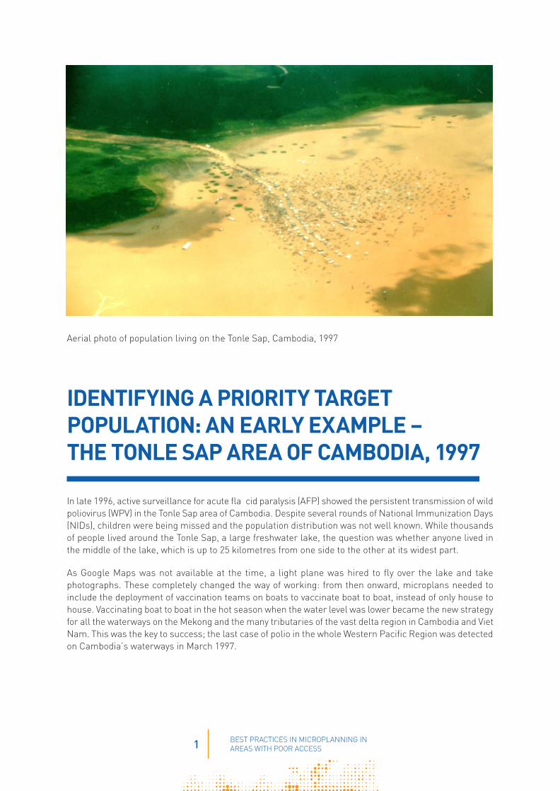
Aerial photo of population living on the Tonle Sap, Cambodia, 1997
IDENTIFYING A PRIORITY TARGET POPULATION: AN EARLY EXAMPLE – THE TONLE SAP AREA OF CAMBODIA, 1997
In late 1996, active surveillance for acute fla cid paralysis (AFP) showed the persistent transmission of wild poliovirus (WPV) in the Tonle Sap area of Cambodia. Despite several rounds of National Immunization Days (NIDs), children were being missed and the population distribution was not well known. While thousands of people lived around the Tonle Sap, a large freshwater lake, the question was whether anyone lived in the middle of the lake, which is up to 25 kilometres from one side to the other at its widest part.
As Google Maps was not available at the time, a light plane was hired to fly over the lake and take photographs. These completely changed the way of working: from then onward, microplans needed to include the deployment of vaccination teams on boats to vaccinate boat to boat, instead of only house to house. Vaccinating boat to boat in the hot season when the water level was lower became the new strategy for all the waterways on the Mekong and the many tributaries of the vast delta region in Cambodia and Viet Nam. This was the key to success; the last case of polio in the whole Western Pacific Region was detected on Cambodia’s waterways in March 1997.
2 BEST PRACTICES IN MICROPLANNING IN AREAS WITH POOR ACCESS
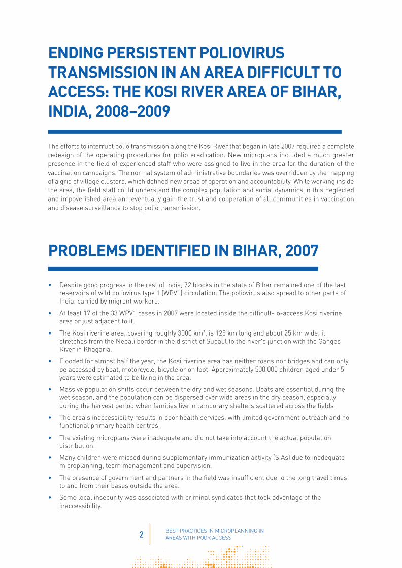
ENDING PERSISTENT POLIOVIRUS TRANSMISSION IN AN AREA DIFFICULT TO ACCESS: THE KOSI RIVER AREA OF BIHAR, INDIA, 2008–2009
The efforts to interrupt polio transmission along the Kosi River that began in late 2007 required a complete redesign of the operating procedures for polio eradication. New microplans included a much greater presence in the field of experienced staff who were assigned to live in the area for the duration of the vaccination campaigns. The normal system of administrative boundaries was overridden by the mapping of a grid of village clusters, which defined new areas of operation and accountability. While working inside the area, the field staff could understand the complex population and social dynamics in this neglected and impoverished area and eventually gain the trust and cooperation of all communities in vaccination and disease surveillance to stop polio transmission.
PROBLEMS IDENTIFIED IN BIHAR, 2007
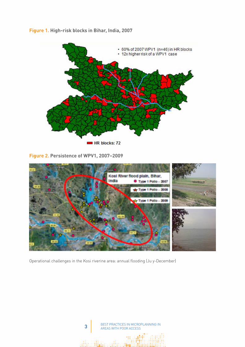
• Despite good progress in the rest of India, 72 blocks in the state of Bihar remained one of the last reservoirs of wild poliovirus type 1 (WPV1) circulation. The poliovirus also spread to other parts of India, carried by migrant workers.
• At least 17 of the 33 WPV1 cases in 2007 were located inside the difficult- o-access Kosi riverine area or just adjacent to it.
• The Kosi riverine area, covering roughly 3000 km², is 125 km long and about 25 km wide; it stretches from the Nepali border in the district of Supaul to the river's junction with the Ganges River in Khagaria.
• Flooded for almost half the year, the Kosi riverine area has neither roads nor bridges and can only be accessed by boat, motorcycle, bicycle or on foot. Approximately 500 000 children aged under 5 years were estimated to be living in the area.
• Massive population shifts occur between the dry and wet seasons. Boats are essential during the wet season, and the population can be dispersed over wide areas in the dry season, especially during the harvest period when families live in temporary shelters scattered across the fields
• The area’s inaccessibility results in poor health services, with limited government outreach and no functional primary health centres.
• The existing microplans were inadequate and did not take into account the actual population distribution.
• Many children were missed during supplementary immunization activity (SIAs) due to inadequate microplanning, team management and supervision.
• The presence of government and partners in the field was insufficient due o the long travel times to and from their bases outside the area.
• Some local insecurity was associated with criminal syndicates that took advantage of the inaccessibility.
3 BEST PRACTICES IN MICROPLANNING IN AREAS WITH POOR ACCESS
Figure 1. High-risk blocks in Bihar, India, 2007
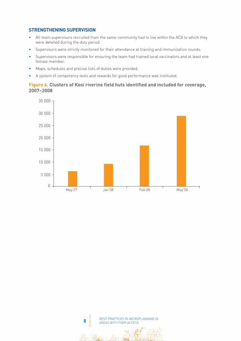
Figure 2. Persistence of WPV1, 2007–2009
Operational challenges in the Kosi riverine area: annual flooding (Ju y-December)

4 BEST PRACTICES IN MICROPLANNING IN AREAS WITH POOR ACCESS
SOLUTIONS
By late 2007, new approaches and a Kosi River comprehensive plan were needed, with at least six months of action in the access-compromised areas (ACAs) covering 24 blocks in eight districts of three subregions. The solutions were:
ESTABLISHING A DEDICATED COORDINATION STRUCTUREA Kosi operational group was formed, chaired by the local government and including the World Health Organization (WHO), the United Nations Children’s Fund (UNICEF) and health department officials, to oversee planning and operations.
SIGNIFICANTLY INCREASING THE FIELD PRESENCE OF HUMAN RESOURCESAdditional human resources were deployed in the field: WHO surveillance medical offi ers (SMOs), UNICEF’s Social Mobilization Network, state and district health staff, international consultants and fieldvolunteers. Their function was to:
• provide greater on-site attention and focus on the underserved population in hard-to-reach areas
• improve microplanning with local details of population distribution
• provide high-quality training for vaccinators
• increase community involvement
• assure quality through intensified moni oring
• establish a network of informers for active AFP surveillance.
The increased presence of field personnel sought to ensure that each person spent the maximum number of days planning and monitoring in the field during the SIAs, including training supervisors and vaccinators, validating microplans and working with communities.
Figure 3. Scaling up NPSP SMOs and field volunteers in the Kosi River area
NPSP: National Polio Surveillance Project; SMO: Regular local surveillance medical offi ers; Internationals: medical offi ers of other nationalities; SMO during activity: local surveillance medical offi ers transferred from other states
0102030
40
5060
70
80
90
Before Aug-07 Dec-07 Feb-08
SMO International SMOs during activity
Field volunteers strength increased from 117 to 164
Num
ber
of m
edic
al o
ffi
ers

5 BEST PRACTICES IN MICROPLANNING IN AREAS WITH POOR ACCESS
CREATING SATELITE FIELD OFFICES AND STAY POINTSBecause of the long distances without roads to and from remote areas, it was essential that staff stay overnight in the field. Satellite field offi es and stay points were set up and staff were expected to stay in the local area rather than in district centres during the preparation and operation of each SIA round.
• WHO posted 37 SMOs to the 12 districts involved, who were assigned to manage specific grids
• The government mobilized medical offi ers to the Kosi River from other blocks outside the area.
• Eventually, 21 satellite offi es were set up that SMOs, government officials and field olunteers could share. The satellite offi es would also be used for training and meetings.
• WHO and UNICEF staff were expected to spend 10 nights per month in the area, accommodated in 37 stay points close to the satellite offi es.
Development of a network of field offices and accommodation
NH: national highway

6 BEST PRACTICES IN MICROPLANNING IN AREAS WITH POOR ACCESS
IDENTIFYING AND MAPPING THE POPULATIONThe available maps did not show the level of detail required. Satellite (GIS) maps were useful to visualize the area, with maps from the United Nations Operation Satellite Applications Programme used as a point of reference. From these, hand-drawn maps could be prepared for planners, supervisors and vaccination teams. The maps had to be updated on a quarterly basis to account for population movements.
The fi st step of the 23-block ACA operation plan consisted of three levels of comprehensive, detailed mapping:
• Level 1: Roads, rivers, tracks and health facilities were added to A3 block maps of village locations, and convenient locations for evening meetings were identified
• Level 2: Maps for this level were based on the level 1 map but included details obtained from level 3 mapping.
• Level 3: SMOs, field olunteers and supervisors established operational bases in the field o map blocks of villages and to show markets, streams, canals, temporary shelters for harvest season, brick kilns, schools, madrasas and other landmarks.
REDEFINING OPERATIONAL AREAS OF ACCOUNTABILITY• In the Kosi riverine area, 23 contiguous blocks belonging to eight administrative districts were
viewed as a single operational block, without regard to the administrative borders. Ease of access was the overriding factor; some blocks could be better accessed from different nearby district centres.
• The area was divided into 31 grids of clusters of about 10 villages, with no villages left between grids. Each grid was allocated to a block of one of the districts. This grid system included 517 villages.
CONDUCTING BORDERLESS MONITORING• Each grid was allocated to a team of WHO and UNICEF staff, field olunteers and local social
mobilization personnel easily accessible from a grid station, without regard to administrative borders.
• It was thus possible to move around grids to monitor areas that were accessible from the home block or from a different block or district.

7 BEST PRACTICES IN MICROPLANNING IN AREAS WITH POOR ACCESS
MODIFYING MICROPLANS BASED ON POPULATION DISTRIBUTION AND MOVEMENTS• Microplans had to take into account major variations in population distribution between dry and wet
seasons.
• During and between rounds, a systematic, ongoing validation of areas was needed – especially to identify field huts ( emporary dwellings during the planting or harvesting seasons) scattered over a wide area, temporary housing, schools, brick kilns, religious sites and congregations, children out of the household and missed areas – to ensure all were included in team movement plans.
• The details in the microplans needed to be updated between each round; for example, boats were required in the wet season, and motorcycles were needed to cover a much wider area in the dry season.
• Microplans were based on designated routes for each team, with a map and set number of households to cover.
• Vaccination teams could vaccinate up to 80 households per day, depending on the season and population distribution. During the harvest season, teams could only manage 40 houses per day because families were widely dispersed.
• Each team was composed of local Anganwadi workers, accredited social health activists, vaccinators from the same community and community mobilizers recruited in the area.
• Transit teams were assigned to important transit sites.
• While vaccinating, teams also identified and t acked all newborn infants in special registers.
ENHANCING ACTIVE AFP SURVEILLANCEWithin the ACAs, no functioning health centres could provide active surveillance reports. Thus it was necessary to identify informers, such as traditional healers living within the community but working outside the health system, and ensure they join orientation sessions.
• Ideally, one informer per village in the Kosi River area was identified and p ovided orientation.
• All informers were visited at least once a month.
• Vaccinators and supervisors were trained to search for AFP cases during the vaccination rounds.
• All suspected AFP cases were discussed at the evening meeting and a full investigation was organized.
Railway embankments provide the only high ground during floods. Note the train on the track.
During the wet season, these typical plains of the Kosi riverine area are under six feet of water.
8 BEST PRACTICES IN MICROPLANNING IN AREAS WITH POOR ACCESS
STRENGTHENING SUPERVISION• All team supervisors recruited from the same community had to live within the ACA to which they
were detailed during the duty period.
• Supervisors were strictly monitored for their attendance at training and immunization rounds.
• Supervisors were responsible for ensuring the team had trained local vaccinators and at least one female member.
• Maps, schedules and precise lists of duties were provided.
• A system of competency tests and rewards for good performance was instituted.
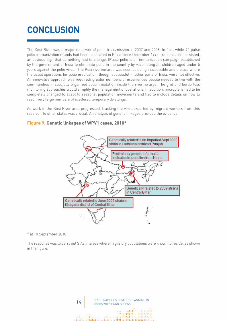
Figure 4. Clusters of Kosi riverine field huts identified and included for coverage, 2007–2008
0
35 000
30 000
25 000
20 000
15 000
10 000
5 000
May’07 Jan’08 Feb’08 May’08

9 BEST PRACTICES IN MICROPLANNING IN AREAS WITH POOR ACCESS
MANAGING THE VACCINE• Adequate numbers of cold boxes and vaccine carriers were prioritized for the Kosi plan.
• A detailed vaccine transport plan showing all routes and pickup and delivery times was developed with sufficient manp wer identified o move cold boxes by boat, bicycle and on foot as needed.
• Vaccine was sent to subdepots in advance, where it could be held in refrigerators.
• From the subdepots, vaccine was sent to various holding points (way points) in cold boxes.
• The most distant sites were supplied fi st using all types of available transport.
Vaccine being carried in a cold box to a distribution point.
TRAINING VACCINATORS AND SUPERVISORS• All training was carried out within the grids of the Kosi River area.
• Interactive training sessions were held by experienced SMOs and government medical offi ers.
• Transit teams were trained separately.
• Vaccinators were registered and absentee vaccinators replaced.
• Supervisors were all reoriented based on the findings and the ollowed-up needed from each round.
MOBILIZING THE COMMUNITY• The underserved area of the Kosi River had little in the way of government infrastructure, roads and
health centres, among others; consequently, there was a reluctance to trust outsiders and outside interventions, such as vaccination.
• Community influen ers, often religious leaders, had to be found and provided orientation sessions, in order to negotiate access even in areas known to harbour lawless gangs.
• Community influen ers accompanied vaccination teams working house to house.
• Messages for the community included the importance of vaccinating every child aged under 5 years and information on forthcoming vaccination rounds.

10 BEST PRACTICES IN MICROPLANNING IN AREAS WITH POOR ACCESS
MONITORING DAILY TEAM OPERATIONS• Trained monitoring personnel (field olunteers) were expected to stay within the grid areas for 7–15
days and were given additional allowances.
• Special guidelines and forms for monitoring were developed.
• Tally sheets were reviewed daily for quality.
• Every team within each grid was monitored on at least 50% of their working days.
• Field volunteers were assigned motorcycle transport to move from team to team.
• SMOs monitored the work of field olunteers.
PROVIDING FEEDBACK• Evening meetings attended by SMOs, field olunteers, social mobilizers and government staff were
scheduled for one hour and held in designated locations in the grid areas.
• The meetings discussed issues regarding daily team work and action to be taken. Supervisors were expected to report on the quality of the work performed by vaccination teams, especially in identifying missed areas for follow-up.
INVOLVING THE GOVERNMENT• Health staff did not visit the Kosi riverine area regularly; its remoteness and long travel times
meant that very few government health facilities were available to the population.
• Senior state officials ecognized the obstacles to polio eradication, and directed district officials o participate in the Kosi operational group and to mobilize block heath staff to be fully engaged in planning, monitoring and feedback operations.
• Government staff based outside the area were encouraged to cooperate with WHO, UNICEF and partners in the borderless monitoring approach.
• Task forces were created by district magistrates who participated in feedback meetings.
• Government boats were authorized for 24-hour use during each SIA round.

11 BEST PRACTICES IN MICROPLANNING IN AREAS WITH POOR ACCESS
RESULTS
Results were immediate: the population in the remote Kosi River area was identified, mapped and reached for immunization. The successful work continued through 2008 and 2009, and had a lasting effect on the circulation of poliovirus. Bihar reported dramatic declines in the number of polio cases: 330 in 2008, 117 in 2009, 9 in 2010 and zero in 2011. The main reservoir of polioviruses had been emptied. Even more rapid progress followed, with the date of onset of India’s last polio case on 13 January 2011 in West Bengal.
Figure 5. Nearly 50% reduction in unimmunized children in hard-to-reach populations, January-April 2008
Figure 6. Massive reduction in missed children in the Kosi area, April-September 2009
% o
f chi
ldre
n fo
undu
nim
mun
ized
by
mon
itori
ng te
ams
who
wer
e fo
llow
ing
th
e im
mun
izat
ion
activ
ities
0
4
8
12
16
Jan-08 Feb-08 Mar-08 Apr-08
Source of data: NPSP monitoring (~12 000 sites monitored each round)
Covering field huts and brick kilns in the Kosi a ea
0
2
4
6
8
10
12
14
Apr-09 May-09 Jun-09 Aug-09 Sep-09
Percent unimmunized children detected by monitors in Kosi River area
Children checked: 1251
Children checked: 2575
Children checked: 2349
Source of data: NPSP monitoring

12 BEST PRACTICES IN MICROPLANNING IN AREAS WITH POOR ACCESS
The coverage of basas (field huts for seasonal habitation) increased with the basa strategy and led to a signifi ant decline in the proportion of unimmunized children.
Field huts in the Kosi riverine area
Figure 7. Increasing coverage of basas in the Kosi area, 2007–2010
0
50 000
100 000
150 000
200 000
250 000
300 000
May 07
Jan 08
Feb 08
May 08
May 09
24 May 09
Jun 09
Nov 09
Dce 09
Jan 10
Feb 10
Mar 10
Apr 10
May 10
Jun 10
Sep 09
Oct 09
Jul 09
Mar 09
Apr 09

13 BEST PRACTICES IN MICROPLANNING IN AREAS WITH POOR ACCESS
Figure 8. Declining proportion of unimmunized children in basas, 2009–2010
% o
f uni
mm
uniz
ed c
hild
ren
0
2
Mar Apr May Jun Aug Sep Oct Nov Dec Jan Feb Mar Apr May Jun
4
6
10
8
12
14
SIA Rounds 2009
14 BEST PRACTICES IN MICROPLANNING IN AREAS WITH POOR ACCESS
CONCLUSION
The Kosi River was a major reservoir of polio transmission in 2007 and 2008. In fact, while 45 pulse polio immunization rounds had been conducted in Bihar since December 1995, transmission persisted, an obvious sign that something had to change. (Pulse polio is an immunization campaign established by the government of India to eliminate polio in the country by vaccinating all children aged under 5 years against the polio virus.) The Kosi riverine area was seen as being inaccessible and a place where the usual operations for polio eradication, though successful in other parts of India, were not effective. An innovative approach was required: greater numbers of experienced people needed to live with the communities in specially organized accommodation inside the riverine area. The grid and borderless monitoring approaches would simplify the management of operations. In addition, microplans had to be completely changed to adapt to seasonal population movements and had to include details on how to reach very large numbers of scattered temporary dwellings.
As work in the Kosi River area progressed, tracking the virus exported by migrant workers from this reservoir to other states was crucial. An analysis of genetic linkages provided the evidence.
Figure 9. Genetic linkages of WPV1 cases, 2010*
* at 10 September 2010
The response was to carry out SIAs in areas where migratory populations were known to reside, as shown in the figu e.

15 BEST PRACTICES IN MICROPLANNING IN AREAS WITH POOR ACCESS
Figure 10. Migratory population covered during Subnational Immunization Days, 2011
The Kosi riverine area became widely recognized as a zone where the innovative initiative against polio in India was successful, and it was visited by the Chief Minister of Bihar and Bill Gates.
Bill Gates visiting the Kosi riverine area.

16 BEST PRACTICES IN MICROPLANNING IN AREAS WITH POOR ACCESS
Interrupting WPV transmission in the Kosi riverine area had a powerful effect on transmission in all of India, with dramatic reduction in the geographic distribution and number of cases, leading to the last onset of a case on 13 January 2011. At the time of writing this document, India has been free from polio for six years.
Figure 11. Geographic distribution and decline of WPV cases, India, 1998, 2009 and 2011
Figure 12. Wild poliovirus cases, India, 1998–2011
* year to date
WPV1 WPV3
0
250
1998 1999 2000 2001 2002 2003 2004 2005 2006 2007 2008 2009 2010 2011*
500
750
1000
1250
1500
1750
2000
WPV1 WPV3
* Year to date Wild poliovirus cases: 1 case in 2011 compared to 33 in 2010


www.polioeradication.org