Best Practices for Caching Maps and Vector Tile...
41
Best Practices for Caching Maps and Vector Tile Layers Tommy Fauvell
Transcript of Best Practices for Caching Maps and Vector Tile...

Best Practices for Caching Maps and
Vector Tile LayersTommy Fauvell

Topics
• Raster tiles and vector tiles
• Raster tiles: relevance and best practices
• Vector tiles: authoring, sharing, and styling
• Please hold all questions until the end

Introduction to raster and vector
tiles

• What are Raster Tiles?
- Pre-rendered snapshots
• Tiling Scheme:
- Origin
- Tile Dimension and Format
- Extent
- CRS
- LOD’s
• Generate Cache
- Cooking
Raster Tiles
L03
L02
L01
L00
Cache

Web GIS and Mobile MappingThe times they are a changin’
• Technology is forcing us to evolve how we deliver content
• The landscape has changed
- GPU and CPU
- High resolution displays
• Devices and browsers are more capable of handling advanced graphics processing

Do we have to rasterize them?
• What if we could leverage the processing power of our mobile devices and
advances in web browser technology?
- Keep vector data as vector
- Ask the device to take on the rendering load
• Vector tiles tilesets deliver layers of geometry and rendering instructions
- Tiles
- Styles
- Sprites
- Fonts
- Index

Tile creation process: Esri basemaps
• Entire world
- ~ 8hrs on a desktop machine
- Tiles ~ 13 GB
- Multiple styles can use the same tiles
• Compared to raster for the entire
world
- ~ many weeks on a server cluster per
map style
- Tiles ~ 20 TB

What do each of the tile formats look like?
• Raster Tiles:
- .bundle
- JPEG
- PNG8, PNG24, PNG32
- PNG
- MIXED
- LERC
• Vector Tiles:
- Mapbox vector tile spec
- Google’s protocol buffers
- Mapbox gl style spec
- .bundle

Authoring Clients / Generation Mechanics
• Raster Tiles:
- MXD’s and Mosaic Datasets
- ArcGIS Desktop
- Manage Tile Cache
- Package Tools
- ArcGIS Pro
- Manage Tile Cache
- Create Map Tile Package
- ArcGIS Server
- Manage Map Server Cache Tiles
• Vector Tiles:
- Map Projects
- ArcGIS Pro v1.2+
- Create Vector Tile Package
- ArcGIS Pro v1.4*
- Integrated sharing workflow

Portal
ArcGIS Server Web GIS
HostingArcGIS Server
ArcGIS.com
Raster Tiles
Vector Tiles
Hosted Tile Layer
Cached Map / Image Services

Use cases
• Raster Tiles:
- Imagery Basemap
- CADRG / ECRG (Scanned Maps)
- Hillshade / Shaded Relief
- 3D Terrain
- StreetMap
- Canvas Maps
- Boundaries and Places
- Transportation
• Vector Tiles:
- StreetMap
- Canvas Maps
- Boundaries and Places
- Transportation

To Summarize
Raster Tiles Vector Tiles Imagery √ X
Projection All Supported CRS All Supported CRS
Updating AOI √ Road Ahead
Changing styles X √
TIle format JPEG, PNG, LERC PBF
Tile consumption ArcGIS Pro
ArcGIS Desktop
Runtime
Web API’s
ArcGIS Earth
ArcGIS Pro 1.3+
Modern Browsers with WebGL support*
Runtime (Quartz Beta2)
Authoring Clients ArcGIS Pro
ArcGIS Desktop
ArcGIS Pro 1.2+
Hosting
Components
ArcGIS for Server
Portal for ArcGIS
ArcGIS.com
Portal for ArcGIS
ArcGIS.com
Export Packages √ Road Ahead
* Current Display Adaptor

Relevance and Best Practices
Raster Tiles

Are Raster Tiles still relevant?
Absolutely…
Image Services
Elevation Services
3D Terrain Services
Map Services

Scalable
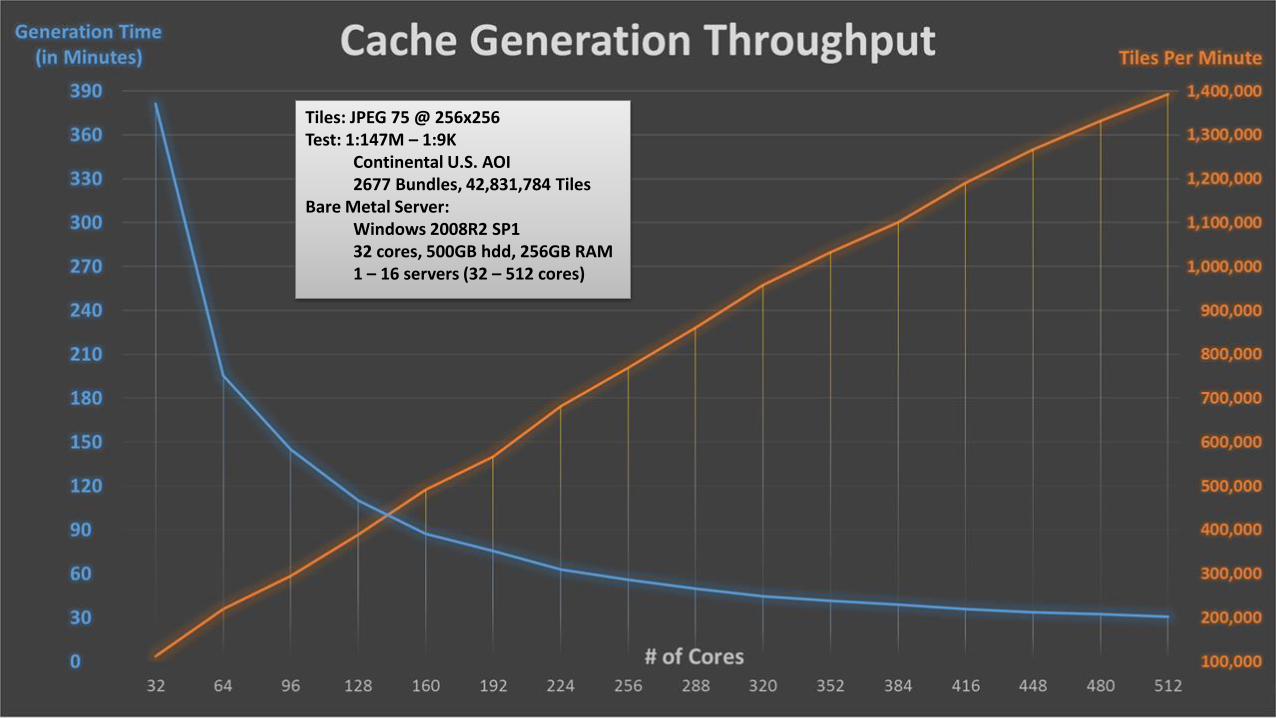
Tiles: JPEG 75 @ 256x256Test: 1:147M – 1:9K
Continental U.S. AOI2677 Bundles, 42,831,784 Tiles
Bare Metal Server: Windows 2008R2 SP132 cores, 500GB hdd, 256GB RAM1 – 16 servers (32 – 512 cores)

Optimize Your Data
Cache smarter…not harder
• File Geodatabase:
- Spatial Index
- Compact
- Compress
- Attribute Index
• Location:
- If you have room, replicate your data onto
each ArcGIS Server machine
• Coordinate reference system:
- On-the-fly vs reproject data

Imagery Basemaps / Image Services
Cache smarter…not harder
• Use JPEG or MIXED tile type
• FGDB and Mosaic Datasets local vs
shared file server location
• Map or Image Service?
- Fixed draw order
- Complex cartographic treatments
• Build pyramids?
- Time and storage
• Use footprints for cache extents
- Dissolve footprints
- Use higher resolution footprints to
constrain cache at larger scales

Imagery Basemaps / Image Services
Cache smarter…not harder
• Prep Mosaic Datasets for caching:
- Use the analyze tools
- Spatial Index
- Attribute Index (Mosaic Method fields)
- Increase max number of rasters
- Increase max number of rows / columns

3D Terrain Image Services
Cache smarter…not harder
• Use LERC
- .1 compression
• CRS:
- Web Mercator – 10.3.1+
- GCS-WGS84 – 10.5
• Build overviews
• Use footprints for cache extents
- Dissolve footprints
- Use higher resolution footprints to
constrain cache at larger scales

Map Documents / Map Service
Cache smarter…not harder
• Use JPEG 90 or PNG
- JPEG for large color variation
- PNG with canvas maps / reference maps
• Annotations / Dynamic Labeling
• Scale Dependencies and Group Layers
• Value-based renderers and attribute
indices
• Map Publishing analyzer

ArcGIS Server
Cache smarter…not harder
• Don’t use Fine, Verbose, or Debug
logging.
• Size your Caching Tools Instances:
- N = # of cores per machine
- Min and Max = N
- 2 – 4GB of RAM x N
- Decrease N if necessary

ArcGIS Server
Cache smarter…not harder
• Size your Cache Controllers Instances:
- Based on the number of simultaneous jobs
you plan to run, ensure you have enough
max instances.

Cache Jobs
Cache smarter…not harder
• Only cache what is necessary
• Use AOI’s with decreasing coverage as
you increase LOD’s
• Break your basemap project into multiple
cache jobs by bracketing LOD’s
- Each job can / should have a unique
AOI
• Only update what has changed
- You don’t need to re-cache everything
if you have partial updates to your data
147M
72M
36M
18M
9M
4M
2M
1M
577K
288K
144K
72K
36K
18K
9K
4K
2K
1K
147M
72M
36M
18M
9M
4M
2M
1M
577K
288K
144K
72K
36K
18K
9K
4K
2K
1K

Best Practices for Raster Tiles
Cache smarter…not harder
• ArcGIS Server scales / leverages system resources
• Optimize your data:
- spatial and attribute indices, compact and compress FGDB, local data
• Configure ArcGIS Server Caching instances
• Optimize MXD and Imagery Projects:
- analyzer results, scale dependencies, Maplex when needed, Mosaic Dataset tuning
• Optimize cache jobs:
- AOI’s per LOD, only cache what is necessary
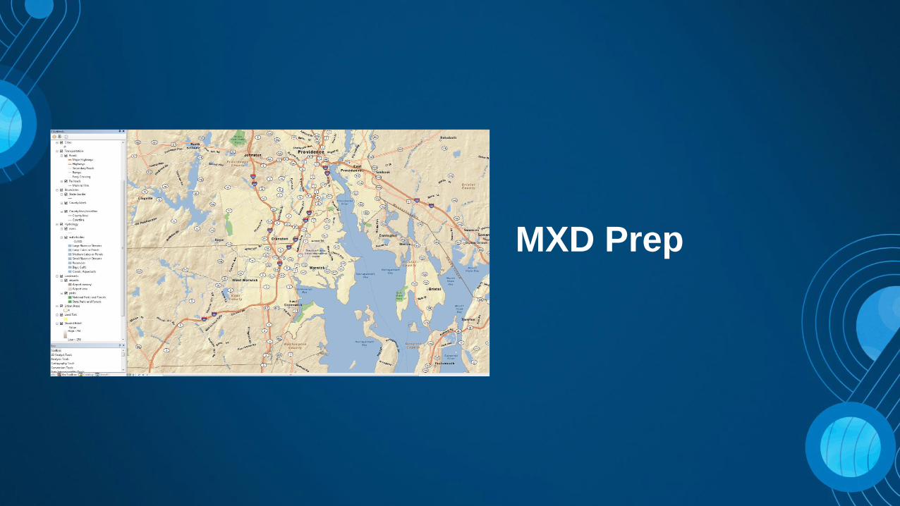
MXD Prep

Yes…yes they are!
Are Vector Tiles really a game
changer?

Design considerations
• Only feature layers with simple, unique value, graduated, or class
breaks symbology supported
• New at Pro 1.4
- Support for Arcade label expressions
- Support for Display filters
• Maps should be re-authored for vector tiles
- Limit number of layers
- Limit duplication of content
- Be mindful of users that want to re-style your maps

Authoring maps
• Several improvements have been made in ArcGIS Pro to create
efficient and cartographically rich tilesets
- Scale dependent capabilities added to symbology
- Alternate symbols added to symbology
- Scale based sizing added to symbology
- Improvement to scale logic

Scale logic changes
• ArcMap and ArcGIS Pro 1.1
- Layers will draw AT and BETWEEN
minimum and maximum scales
• ArcGIS Pro 1.2, layers don’t draw at
max scale by default
- -Check “Draw up to and including the
maximum scale in scale ranges” to
revert to old behavior
- This is checked for old Pro projects or
imported ArcMap maps
1: 1 million
1: 500,000
1: 10,000
Option checked:Both draw
Option unchecked:Layer 2 draws
Layer 1
Layer 2

Authoring / Sharing
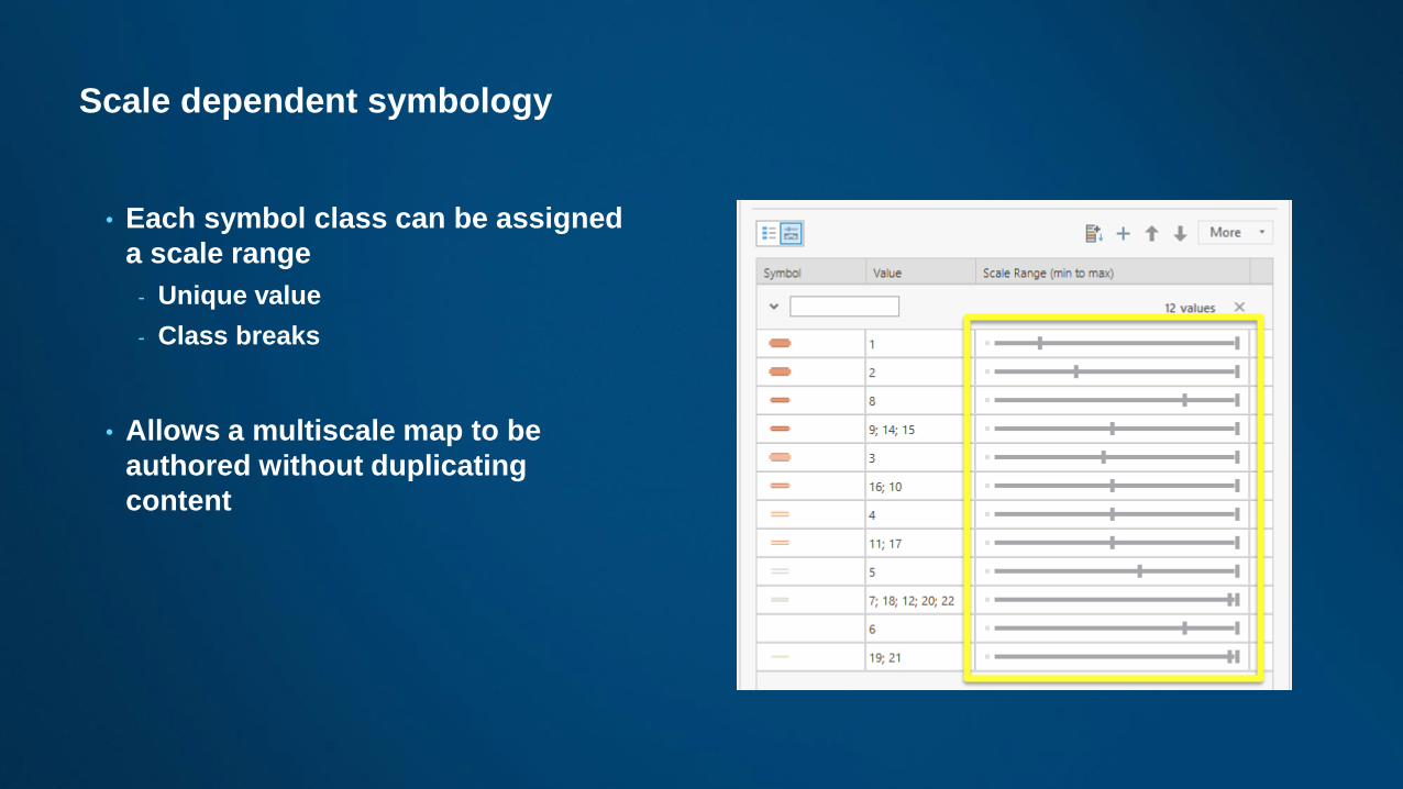
Scale dependent symbology
• Each symbol class can be assigned
a scale range
- Unique value
- Class breaks
• Allows a multiscale map to be
authored without duplicating
content

Alternate symbols for symbology
• Symbol classes can switch
symbols at scales
- Unique value
• Allows you to change the
appearance of a symbol without
duplicating layer
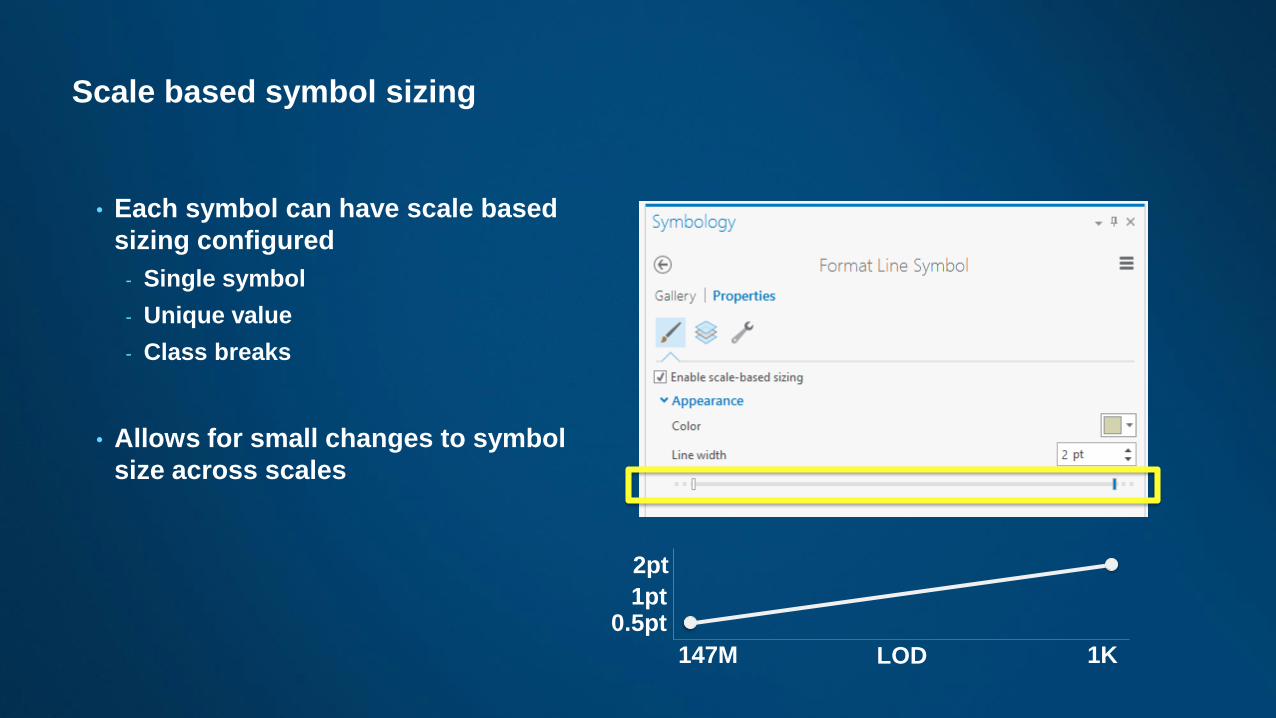
Scale based symbol sizing
• Each symbol can have scale based
sizing configured
- Single symbol
- Unique value
- Class breaks
• Allows for small changes to symbol
size across scales
1pt
2pt
0.5pt
LOD147M 1K

Styling vector tiles
• Simple Style Copy
- Save tile layer to your Portal or Online account
• Hand editing JSON
- Update map item
• Two additional sample Vector Styling Apps simplify this:
- Vector Style JSON Editor - GitHub
- Vector Basemap Style Editor - GitHub

Styling demo

Summary
Raster Tiles
• Big Footprint
- TB’s of cache data
- Single SOC for Map / Image Service
• Generation can consumes lots of resources
- nCPU x Time = Weeks
• Most flexible
- Any CRS
- Any Data (imagery or vector)
- Any Client
Vector Tiles
• Small footprint
- 13 GB for whole world
- Hosted tile layer
• Generation consumes less resources
- CPU x Time = hours
• Getting more flexible
- Any supported CRS*
- Vectors, no imagery
- Modern browsers with WebGL
- Pro v 1.3

Questions?

Please Take Our Survey on the Esri Events App!
Select the session
you attended
Scroll down to find
the survey
Complete Answers
and Select “Submit”
Download the Esri Events
app and find your event

Print Your Certificate of Attendance
Print stations located in the 140 Concourse
Monday
12:30 PM – 6:30 PM
GIS Solutions Expo,
Hall B
5:15 PM – 6:30 PM
Expo Social,
Hall B
Tuesday
10:45 AM – 5:15 PM
GIS Solutions Expo,
Hall B
6:30 PM – 9:30 PM
Networking Reception,
Smithsonian National Air
and Space Museum