AVIATION OCCURRENCE REPORT CONTROLLED FLIGHT INTO …
36
AVIATION OCCURRENCE REPORT CONTROLLED FLIGHT INTO TERRAIN BEARSKIN LAKE AIR SERVICES LTD. BEECHCRAFT A100 C-GYQT BIG TROUT LAKE AIRPORT, ONTARIO 3 mi NW 21 FEBRUARY 1995 REPORT NUMBER A95C0026
Transcript of AVIATION OCCURRENCE REPORT CONTROLLED FLIGHT INTO …
AVIATION OCCURRENCE REPORT
CONTROLLED FLIGHT INTO TERRAIN
BEARSKIN LAKE AIR SERVICES LTD.BEECHCRAFT A100 C-GYQT
BIG TROUT LAKE AIRPORT, ONTARIO 3 mi NW21 FEBRUARY 1995
REPORT NUMBER A95C0026
MANDATE OF THE TSB
The Canadian Transportation Accident Investigation and Safety Board Actprovides the legal framework governing the TSB's activities. Basically, theTSB has a mandate to advance safety in the marine, pipeline, rail, andaviation modes of transportation by:
! conducting independent investigations and, if necessary, publicinquiries into transportation occurrences in order to make findings asto their causes and contributing factors;
! reporting publicly on its investigations and public inquiries and on therelated findings;
! identifying safety deficiencies as evidenced by transportationoccurrences;
! making recommendations designed to eliminate or reduce any suchsafety deficiencies; and
! conducting special studies and special investigations ontransportation safety matters.
It is not the function of the Board to assign fault or determine civil or criminalliability. However, the Board must not refrain from fully reporting on thecauses and contributing factors merely because fault or liability might beinferred from the Board's findings.
INDEPENDENCE
To enable the public to have confidence in the transportation accidentinvestigation process, it is essential that the investigating agency be, and beseen to be, independent and free from any conflicts of interest when itinvestigates accidents, identifies safety deficiencies, and makes safetyrecommendations. Independence is a key feature of the TSB. The Boardreports to Parliament through the President of the Queen's Privy Council forCanada and is separate from other government agencies and departments.Its independence enables it to be fully objective in arriving at its conclusionsand recommendations.
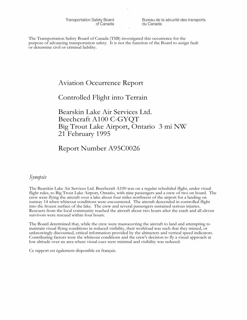
The Transportation Safety Board of Canada (TSB) investigated this occurrence for thepurpose of advancing transportation safety. It is not the function of the Board to assign faultor determine civil or criminal liability.
Aviation Occurrence Report
Controlled Flight into Terrain
Bearskin Lake Air Services Ltd.Beechcraft A100 C-GYQTBig Trout Lake Airport, Ontario 3 mi NW21 February 1995
Report Number A95C0026
Synopsis
The Bearskin Lake Air Services Ltd. Beechcraft A100 was on a regular scheduled flight, under visualflight rules, to Big Trout Lake Airport, Ontario, with nine passengers and a crew of two on board. Thecrew were flying the aircraft over a lake about four miles northwest of the airport for a landing onrunway 14 when whiteout conditions were encountered. The aircraft descended in controlled flightinto the frozen surface of the lake. The crew and several passengers sustained serious injuries. Rescuers from the local community reached the aircraft about two hours after the crash and all elevensurvivors were rescued within four hours.
The Board determined that, while the crew were manoeuvring the aircraft to land and attempting tomaintain visual flying conditions in reduced visibility, their workload was such that they missed, orunknowingly discounted, critical information provided by the altimeters and vertical speed indicators. Contributing factors were the whiteout conditions and the crew's decision to fly a visual approach atlow altitude over an area where visual cues were minimal and visibility was reduced.
Ce rapport est également disponible en français.

TABLE OF CONTENTS
TRANSPORTATION SAFETY BOARD iii
Table of ContentsPage
1.0 Factual Information . . . . . . . . . . . . . . . . . . . . . . . . . . . . . . . . . . . . . . . . . . . . . . . . . . . . . 1
1.1 History of the Flight . . . . . . . . . . . . . . . . . . . . . . . . . . . . . . . . . . . . . . . . . . . . . . . . . . 1
1.2 Injuries to Persons . . . . . . . . . . . . . . . . . . . . . . . . . . . . . . . . . . . . . . . . . . . . . . . . . . . . 2
1.3 Damage to Aircraft . . . . . . . . . . . . . . . . . . . . . . . . . . . . . . . . . . . . . . . . . . . . . . . . . . . 2
1.4 Other Damage . . . . . . . . . . . . . . . . . . . . . . . . . . . . . . . . . . . . . . . . . . . . . . . . . . . . . . . 2
1.5 Personnel Information . . . . . . . . . . . . . . . . . . . . . . . . . . . . . . . . . . . . . . . . . . . . . . . . 3
1.6 Aircraft Information . . . . . . . . . . . . . . . . . . . . . . . . . . . . . . . . . . . . . . . . . . . . . . . . . . 4
1.7 Meteorological Information . . . . . . . . . . . . . . . . . . . . . . . . . . . . . . . . . . . . . . . . . . . . 5
1.8 Aids to Navigation . . . . . . . . . . . . . . . . . . . . . . . . . . . . . . . . . . . . . . . . . . . . . . . . . . . . 5
1.9 Communications . . . . . . . . . . . . . . . . . . . . . . . . . . . . . . . . . . . . . . . . . . . . . . . . . . . . . 6
1.10 Aerodrome Information . . . . . . . . . . . . . . . . . . . . . . . . . . . . . . . . . . . . . . . . . . . . . . . 6
1.11 Flight Recorders . . . . . . . . . . . . . . . . . . . . . . . . . . . . . . . . . . . . . . . . . . . . . . . . . . . . . . 6
1.12 Wreckage and Impact Information . . . . . . . . . . . . . . . . . . . . . . . . . . . . . . . . . . . . . . 6
1.13 Medical Information . . . . . . . . . . . . . . . . . . . . . . . . . . . . . . . . . . . . . . . . . . . . . . . . . . 7
1.14 Fire . . . . . . . . . . . . . . . . . . . . . . . . . . . . . . . . . . . . . . . . . . . . . . . . . . . . . . . . . . . . . . . . 7
1.15 Survival Aspects . . . . . . . . . . . . . . . . . . . . . . . . . . . . . . . . . . . . . . . . . . . . . . . . . . . . . . 8
1.15.1 First Aid Kit . . . . . . . . . . . . . . . . . . . . . . . . . . . . . . . . . . . . . . . . . . . . . . . . . . . . . . . . . 8
1.15.2 Survival Kit . . . . . . . . . . . . . . . . . . . . . . . . . . . . . . . . . . . . . . . . . . . . . . . . . . . . . . . . . . 8
1.15.3 Emergency Locator Transmitter (ELT) . . . . . . . . . . . . . . . . . . . . . . . . . . . . . . . . . . . 8
1.16 Tests and Research . . . . . . . . . . . . . . . . . . . . . . . . . . . . . . . . . . . . . . . . . . . . . . . . . . . 9
1.16.1 Altimeters . . . . . . . . . . . . . . . . . . . . . . . . . . . . . . . . . . . . . . . . . . . . . . . . . . . . . . . . . . . 9
1.16.2 Vertical Speed Indicators . . . . . . . . . . . . . . . . . . . . . . . . . . . . . . . . . . . . . . . . . . . . . . . 10
1.16.3 Horizontal Stabilizer Trim Actuator . . . . . . . . . . . . . . . . . . . . . . . . . . . . . . . . . . . . . . 10
1.16.4 Passenger Seat-Belts . . . . . . . . . . . . . . . . . . . . . . . . . . . . . . . . . . . . . . . . . . . . . . . . . . . 10
1.17 Organizational and Management Information . . . . . . . . . . . . . . . . . . . . . . . . . . . . . . 10
1.18 Additional Information . . . . . . . . . . . . . . . . . . . . . . . . . . . . . . . . . . . . . . . . . . . . . . . 10
1.18.1 Whiteout . . . . . . . . . . . . . . . . . . . . . . . . . . . . . . . . . . . . . . . . . . . . . . . . . . . . . . . . . . . . 10
1.18.2 AWOS Visibility and Ceiling . . . . . . . . . . . . . . . . . . . . . . . . . . . . . . . . . . . . . . . . . . . . 11
1.18.3 AWOS Altimeter Setting . . . . . . . . . . . . . . . . . . . . . . . . . . . . . . . . . . . . . . . . . . . . . . . 11
1.18.4 RAMP Radar Data . . . . . . . . . . . . . . . . . . . . . . . . . . . . . . . . . . . . . . . . . . . . . . . . . . . . 12
1.18.5 Controlled Flight into Terrain . . . . . . . . . . . . . . . . . . . . . . . . . . . . . . . . . . . . . . . . . . . 12
1.18.6 Situational Awareness . . . . . . . . . . . . . . . . . . . . . . . . . . . . . . . . . . . . . . . . . . . . . . . . . 12
1.18.7 Information Processing . . . . . . . . . . . . . . . . . . . . . . . . . . . . . . . . . . . . . . . . . . . . . . . . 12
1.18.8 Ground Proximity Warning System . . . . . . . . . . . . . . . . . . . . . . . . . . . . . . . . . . . . . . 13
1.18.9 Approach Chart Holders . . . . . . . . . . . . . . . . . . . . . . . . . . . . . . . . . . . . . . . . . . . . . . . 13
1.18.10 Visual Flight Rules . . . . . . . . . . . . . . . . . . . . . . . . . . . . . . . . . . . . . . . . . . . . . . . . . . . . 13
TABLE OF CONTENTS
iv TRANSPORTATION SAFETY BOARD
2.0 Analysis . . . . . . . . . . . . . . . . . . . . . . . . . . . . . . . . . . . . . . . . . . . . . . . . . . . . . . . . . . . . . . . . . . . 15
2.1 Introduction . . . . . . . . . . . . . . . . . . . . . . . . . . . . . . . . . . . . . . . . . . . . . . . . . . . . . . . . . 15
2.2 Aircraft Altimeters . . . . . . . . . . . . . . . . . . . . . . . . . . . . . . . . . . . . . . . . . . . . . . . . . . . . 15
2.3 Automated Weather Observation System . . . . . . . . . . . . . . . . . . . . . . . . . . . . . . . . . 15
2.4 Decision Making on Approach . . . . . . . . . . . . . . . . . . . . . . . . . . . . . . . . . . . . . . . . . . 16
2.5 Survival Issues . . . . . . . . . . . . . . . . . . . . . . . . . . . . . . . . . . . . . . . . . . . . . . . . . . . . . . . 17
2.5.1 ELT . . . . . . . . . . . . . . . . . . . . . . . . . . . . . . . . . . . . . . . . . . . . . . . . . . . . . . . . . . . . . . . . 17
2.5.2 First Aid Kit . . . . . . . . . . . . . . . . . . . . . . . . . . . . . . . . . . . . . . . . . . . . . . . . . . . . . . . . . 18
2.5.3 Survival Kit . . . . . . . . . . . . . . . . . . . . . . . . . . . . . . . . . . . . . . . . . . . . . . . . . . . . . . . . . . 18
2.5.4 Seat-Belt Attachment Fittings . . . . . . . . . . . . . . . . . . . . . . . . . . . . . . . . . . . . . . . . . . . 18
3.0 Conclusions . . . . . . . . . . . . . . . . . . . . . . . . . . . . . . . . . . . . . . . . . . . . . . . . . . . . . . . . . . . . . . 19
3.1 Findings . . . . . . . . . . . . . . . . . . . . . . . . . . . . . . . . . . . . . . . . . . . . . . . . . . . . . . . . . . . . 19
3.2 Causes . . . . . . . . . . . . . . . . . . . . . . . . . . . . . . . . . . . . . . . . . . . . . . . . . . . . . . . . . . . . . . 20
4.0 Safety Action . . . . . . . . . . . . . . . . . . . . . . . . . . . . . . . . . . . . . . . . . . . . . . . . . . . . . . . . . . . . . 21
4.1 Action Taken . . . . . . . . . . . . . . . . . . . . . . . . . . . . . . . . . . . . . . . . . . . . . . . . . . . . . . . . 21
4.1.1 Airport Elevation . . . . . . . . . . . . . . . . . . . . . . . . . . . . . . . . . . . . . . . . . . . . . . . . . . . . . 21
4.1.2 Visibility Requirement in Uncontrolled Airspace . . . . . . . . . . . . . . . . . . . . . . . . . . . 21
4.1.3 Operating Instruction for ELTs . . . . . . . . . . . . . . . . . . . . . . . . . . . . . . . . . . . . . . . . . 21
4.1.4 Ground Proximity Warning System (GPWS) . . . . . . . . . . . . . . . . . . . . . . . . . . . . . . 21
4.2 Action Required . . . . . . . . . . . . . . . . . . . . . . . . . . . . . . . . . . . . . . . . . . . . . . . . . . . . . . 22
4.2.1 Post-Accident Survivability . . . . . . . . . . . . . . . . . . . . . . . . . . . . . . . . . . . . . . . . . . . . . 22
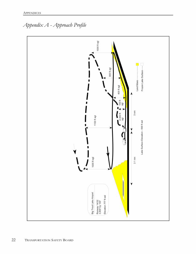
5.0 AppendicesAppendix A - Approach Profile . . . . . . . . . . . . . . . . . . . . . . . . . . . . . . . . . . . . . . . . . . . . . . . . . . 25
Appendix B - List of Supporting Reports . . . . . . . . . . . . . . . . . . . . . . . . . . . . . . . . . . . . . . . . . . 27

TABLE OF CONTENTS
TRANSPORTATION SAFETY BOARD v

TABLE OF CONTENTS
vi TRANSPORTATION SAFETY BOARD

TABLE OF CONTENTS
TRANSPORTATION SAFETY BOARD vii
TABLE OF CONTENTS
viii TRANSPORTATION SAFETY BOARD
Appendix C - Glossary . . . . . . . . . . . . . . . . . . . . . . . . . . . . . . . . . . . . . . . . . . . . . . . . . . . . . . . . . 29
FACTUAL INFORMATION
1 See Glossary for all abbreviations and acronyms.
2 All times are CST (Coordinated Universal Time [UTC] minus six hours) unless otherwise stated.
3 Units are consistent with official manuals, documents, reports, and instructions used by or issued to thecrew.
TRANSPORTATION SAFETY BOARD 1
1.0 Factual Information
1.1 History of the Flight
The crew of the Beechcraft A100, C-GYQT, were conducting a scheduled flight from Sioux Lookout,Ontario, to Big Trout Lake, Ontario, as Bearskin (BLS)1 324. BLS 324 departed Sioux Lookout withnine passengers and a crew of two at 1133 central standard time (CST)2 and arrived in the vicinity of BigTrout Lake at approximately 1240. The captain briefed an instrument approach with a circlingprocedure to runway 14. On descent to the radio beacon, the crew reportedly encountered flightvisibilities of one mile and were in visual contact with the ground. When the aircraft was less than fivemiles3 from the airport, the crew heard a position report from another aircraft completing an approachto the airport. To ensure safe separation from the aircraft ahead, the captain elected to fly under visualflight rules to the southwest of the airport.
Air Traffic Services radar data was obtained from the Big Trout Lake radar source. The radar dataindicated that the crew descended to about 150 feet above ground level (agl) approximately 4.5 milesfrom the end of the landing runway and maintained 200 to 300 feet agl for some 50 seconds prior toimpact. Immediately prior to impact, the radar data indicated that the aircraft was about 3 1/2 milesfrom the runway at about 300 feet agl and descending at more than 1,200 feet per minute.
Throughout the approach, the first officer flew the aircraft visually with occasional reference to hisinstruments, while the captain navigated and maintained terrain clearance by visual reference to theterrain and issued instructions to the first officer. At approximately five miles from the runway, thecrew turned onto the extended centre line of the runway and received a radio report from the otheraircraft of local visibilities of less than 1/2 mile. The aircraft flew inbound over a wide expanse of lake,and the captain lowered the flaps in preparation for landing. Shortly thereafter, the captain becameconcerned with the reducing visibility and looked in the Company Approach Procedures binder that heheld on his lap. The captain was aware of the danger of whiteout and intended to revert to instrumentflight if whiteout were encountered. He had not previously removed the approach chart for Big TroutLake and clipped it in the approach chart holder because he had discovered that the binder rings werebroken and taped shut when he had performed his initial approach briefing. He intended to providenew approach information to the first officer so that a full instrument approach could be initiated fromtheir current position. When the captain looked up from the binder, he observed the altimeterindicating a descent through 1,000 feet above sea level (asl) and called to the first officer, "Watch youraltitude." Before a recovery could be initiated, the aircraft struck the frozen surface of the lake andbounced into the air. The captain initiated a recovery and then, concerned with the airworthiness of theaircraft, reduced power and attempted to land straight ahead. The aircraft crashed onto the frozensurface of the lake about 3/4 mile beyond the initial impact location.
All passengers and crew survived the accident. However, the crew and several passengers sustainedserious injuries. Rescuers from the local community reached the aircraft about two hours after thecrash and all survivors were rescued within four hours. The more seriously injured were experiencingthe effects of hypothermia when rescued.

FACTUAL INFORMATION
2 TRANSPORTATION SAFETY BOARD
The accident occurred at 1248 CST, approximately three miles northwest of Big Trout Lake Airport, atlatitude 53°49'N, longitude 089°53'W, at an elevation of 690 feet asl.
1.2 Injuries to Persons
Crew Passengers Others Total
Fatal - - - -
Serious 2 7 - 9
Minor/None - 2 - 2
Total 2 9 - 11
1.3 Damage to Aircraft
The aircraft was damaged beyond economical repair.
1.4 Other Damage
The aircraft's main fuel tanks ruptured on impact, and the resulting fuel spill contaminated the snow inthe area of the impact.
1.5 Personnel Information
Captain First Officer
Age 29 27
Pilot Licence ATPL CPL
Medical Expiry Date 01 Jul 1995 01 Mar 1995
Total Flying Hours 5,000 2,300
Hours on Type 1,500 800
Hours Last 90 Days 195 210
Hours on Type Last 90 Days 195 210
Hours on Duty Prior to Occurrence 3.5 3.5
Hours Off Duty Prior to Work Period 24 15
The crew was certified and qualified for the flight in accordance with the existing regulations.

FACTUAL INFORMATION
TRANSPORTATION SAFETY BOARD 3
The company has followed a policy of having all of their pilots receive crew resource management(CRM) training. The captain had received CRM training, but the first officer, who was a relatively newhire, had not received the training.

FACTUAL INFORMATION
4 TRANSPORTATION SAFETY BOARD
1.6 Aircraft Information
Manufacturer Beech Aircraft Corporation
Type King Air A100
Year of Manufacture 1974
Serial Number B-189
Certificate of Airworthiness (Flight Permit) Valid
Total Airframe Time 13,739 hr
Engine Type (number of) PT6A-28 (2)
Propeller/Rotor Type (number of) Hartzell HC-B4TN-3 (2)
Maximum Allowable Take-off Weight 11,500 lb
Recommended Fuel Type(s) Jet-A, Jet A-1, Jet B
Fuel Type Used Jet B
A review of available records indicated that the aircraft was equipped and maintained in accordancewith existing regulations and approved procedures except for the following two discrepancies:
i. the propeller synchrophaser had been removed from the aircraft because ofunserviceability, but this action had not been logged in the Journey Log; and,
ii. the radar altimeter (radalt) had been declared unserviceable [non-specific] in the JourneyLog and subsequently logged in the Deferred Items Log section of the Aircraft JourneyLog. However, the radalt had not been placarded unserviceable in the cockpit, as per theplacarding requirements outlined in the company Maintenance Control Manual. Thecaptain was aware of the unserviceability, and the radalt was not used during theapproach. The radalt was found with its switch in the OFF position and the bug set atapproximately 1,050 feet.
FACTUAL INFORMATION
TRANSPORTATION SAFETY BOARD 5
1.7 Meteorological Information
Big Trout Lake is served by an Automated Weather Observation System (AWOS) and a voicegeneration system. The AWOS provides up-to-the-minute weather information to the pilot via radio. Meteorologists use AWOS observations in the production of aerodrome and area forecasts.
The weather forecast for Big Trout Lake, issued at 0500 CST, and obtained by the crew prior todeparture, indicated that for their time of arrival, there would be an occasional sky condition of 3,000feet overcast with visibility greater than six miles in light snow. The weather forecast issued at 1100,just prior to their departure, was substantially the same. This forecast was amended at 1227 to anoccasional sky condition of 1,000 feet overcast with visibility of one mile in light snow. However, theweather the flight encountered was localized and corresponded more closely to the visibility reportsfrom the AWOS.
The AWOS report received by the crew before they began their approach procedures was made at 1212and indicated that the cloud was scattered at 900 and 2,100 feet agl and the visibility was 1.3 miles inlight snow. The weather report available from the AWOS by radio broadcast as the crew began theirapproach was made at 1239 and indicated that the sky was clear below 10,000 feet with visibility of9/10 of a mile in light snow. The temperature was -14° Celsius, and the altimeter setting was 29.96inches of mercury.
From the observations taken at the AWOS over the period of the occurrence, the visibility droppedfrom 9/10 of a mile at 1239 to 1/2 mile at 1300. The winds were from the south at 13 to 15 knots. The AWOS did not report any obscured or partially obscured ceiling in the precipitation.
1.8 Aids to Navigation
The airport is served by a non-directional beacon (NDB) located approximately 0.6 nautical miles (nm)west of the runway; the frequency of the NDB is 328 kilohertz (KHz), which was tuned to the aircraft'sautomatic direction-finder (ADF) radio. An interim Transport Canada Approved Company InstrumentApproach Procedure, dated 07 November 1994, provides a circling approach to the runway with aminimum descent altitude of 1,280 feet asl and an advisory visibility of two miles. The elevation of theairfield specified by the chart is 777 feet. Company instrument approach procedure charts areissued on 8½- by 11-inch paper and are kept in three-ring binders by the company. The one binderprovided in the occurrence aircraft was broken and the individual charts could not be easily removed bythe crew. The captain placed the binder on his lap during the approach.
The aircraft was equipped with a global positioning system (GPS), which was not an approvednavigation aid for instrument flight rules (IFR) navigation, and was used by the crew as a backupnavigation aid.
1.9 Communications
The airport is located in uncontrolled airspace. An aerodrome traffic frequency (ATF) is designatedwithin a 5 nm radius below 3,700 feet asl. Prior to descent into Big Trout Lake, the captaincommunicated on the company frequency with another Bearskin flight that had departed Big TroutLake about 30 minutes earlier. The crew of the departing flight reported the weather as one mile insnow, with snow showers to the west. On arrival at Big Trout Lake, the captain communicated on theATF with the crew of another company who were flying a right-hand visual approach to runway 14.
1.10 Aerodrome Information
FACTUAL INFORMATION
6 TRANSPORTATION SAFETY BOARD
Big Trout Lake is a certified airport operated by the Ontario Government. The airport elevation listedin the Canada Flight Supplement dated 08 December 1994 and used by the occurrence crew is 738 feet. This elevation is 39 feet lower than the elevation specified on the Company Approach plate. Theelevation specified on the Company Approach plate is based on a more recent survey and is the correctairport elevation for Big Trout Lake. Runway 14/32 is gravel and 3,900 feet long by 100 feet wide. ARAMP radar site is located approximately 1,700 feet west of the threshold of runway 14.
1.11 Flight Recorders
The aircraft was not equipped with any flight recorders, nor was there any regulatory requirement forthe aircraft to be so equipped.
1.12 Wreckage and Impact Information
The initial impact occurred on the frozen surface of Big Trout Lake approximately 3.4 nm northwest ofthe airport on the extended centre line of the runway and approximately 3.1 nm northwest of theRAMP radar site. The belly luggage pod was destroyed on first impact and the contents were strewnonto the ice. The trail of baggage and luggage pod debris was oriented on a heading of approximately140/ magnetic (M). Snow, which fell and was compacted by the wind after the occurrence, obliteratedany potential evidence of wing or propeller strikes in the initial impact area.
The second (main) impact site was located on the ice surface of the lake approximately 2.7 nmnorthwest of the airport, slightly to the left of the extended centre line of the runway. The aircraftcrashed while in a left bank, nose-low attitude, on a heading of approximately 071/M. The nose and theunderside of the fuselage were crushed and the fuselage was buckled in several places; however, themain shape of the cabin was retained and all windshields and windows maintained their integrity. Theleft wing attachment fittings were broken, and the left wing was buckled in several places. The topsurface of the right wing appeared undamaged; however, the rear spar of the right wing was fractured,and the right inboard flap cables were stretched and internal sleeves displaced by the forwardmovement of the right wing during the impact. The rear fuselage was wrinkled and buckled in severalareas and both rear horizontal stabilizer attachment brackets were broken, which allowed the stabilizerto move freely.
The landing gear were in the retracted position, and the flaps were extended to the 30/ position. Allprimary flight controls were attached, and the continuity of controls was verified. The wings andhorizonal stabilizer had a slight accumulation of rime ice along the leading edge. The strips of rime icewere about 1 to 1.5 inches wide and up to 1/8 inch thick. In several places, the thin strips of rime icehad been covered with oil during the impact sequence.
Both engines were displaced to the left by the downward and forward motion of the aircraft during theimpact sequence. The propeller of the left engine was found approximately 150 feet behind the aircraftat the start of the second impact wreckage trail. All four blades of this propeller were still in the hub. Three of the four blades were severely curled along 3/4 of their respective lengths. Examination of thepropeller mounting flange revealed that the mounting bolt threads had failed. All of the bolts werefound in the propeller shaft mounting flange on the engine. The propeller and gearbox of the right-hand engine were detached as a unit and became trapped under the engine against the fuselage. Theright propeller blades were severely curled in a manner similar to the left propeller blades. Thisevidence is consistent with the engines providing high power as reported by the crew.
All seats, with the exception of the crew seats and the bench seat at the back of the aircraft, had beenremoved by rescuers. Three seat-belt attachment fittings had broken during the impact. The captain's
FACTUAL INFORMATION
TRANSPORTATION SAFETY BOARD 7
seat pan was badly deformed and the mounting structure under the seat was broken. The seat trackattachments maintained their integrity, but the vertical seat posts had failed as the cabin floor wasdriven upwards. The shoulder harnesses from both of the pilot seats had been cut by rescuers, leavingonly three or four inches of shoulder harness material at the inertia reel. The bulkheads separating thecrew from passengers had also been removed by rescue personnel.
1.13 Medical Information
There was no evidence that incapacitation or physiological factors affected the crew's performance.
1.14 Fire
There was no fire either before or after the occurrence. Emergency response services (ERS) were notavailable.
1.15 Survival Aspects
1.15.1 First Aid Kit
Air Navigation Order (ANO) Series II, No. 11, the Aircraft First Aid Kit Order, requires that aircraft beequipped with first aid kits for the treatment of injuries likely to occur in flight or in minor accidents. One of the passengers was a nurse who treated the survivors using the aircraft first aid kit. Shereported that the first aid kit was not adequate to deal with the injuries that the passengers received. Inparticular, there was a critical lack of pressure dressings to stop bleeding. The nurse improvised andused packed snow to control bleeding.
1.15.2 Survival Kit
ANO Series V, No. 12, the Sparsely Settled Areas Order, specifies the type of emergency equipment thatmust be carried on aircraft operating in the sparsely settled region of Canada. The order permitsexceptions for air carriers as authorized in the air carrier's operations manual. The Bearskin Lake AirServices Operations Manual, which was approved by Transport Canada, exempted this flight from therequirement to carry a winter sleeping bag for each person on board.
All personal baggage and equipment was lost when the baggage pod was crushed during the initialimpact. A small survival kit carried in the aircraft cabin contained some foil (space) blankets that wereused to protect the most seriously injured. However, the nurse reported that hypothermia occurred inthe two most seriously injured survivors who were immobile.
1.15.3 Emergency Locator Transmitter (ELT)
ANO Series II, No. 17, the Emergency Locator Transmitter Order, requires that information concerning thelocation and operation of the emergency locator transmitter be made available to the passengers bymeans of a readily visible placard located in the aircraft's cabin or by other equivalent means. After thecrash, the passengers had difficulty understanding the placard and could only follow its instructionswith the aid of the seriously injured captain. The crew members and the passengers had difficultyascertaining if the ELT had activated automatically during the crash. When they attempted to activatethe ELT manually, they also had difficulty in determining if it was activated. Eventually, the crewturned on the aircraft electrical power to hear the ELT tone on the aircraft radio. The ELT didfunction correctly, and a search and rescue aircraft was dispatched and evacuated the passengers andcrew to Winnipeg.
FACTUAL INFORMATION
8 TRANSPORTATION SAFETY BOARD
The ELT is manually activated by a small toggle switch accessible through a push-in access panelapproximately the size of a quarter coin. The access panel is located on the exterior of the aircraftfuselage just forward of the starboard stabilizer. The location is identified by a placard. The on/offpositions of the toggle switch were difficult to identify when viewed through the small access panel.
1.16 Tests and Research
1.16.1 Altimeters
The aircraft was equipped with three pressure altimeters and one radar altimeter. The aircraft was notequipped with either altimeter reference markers or an altitude alerting system. The radar altimeter wasnot functional and not used by the crew. The pressure altimeter on the captain's side of the instrumentpanel was an encoding altimeter and required aircraft electrical power to function. Encoding altimetersprovide the aircraft's altitude to air traffic control (ATC) radars via the aircraft's transponder. Thepressure altimeter on the co-pilot's side of the instrument panel was not an encoding altimeter and didnot require aircraft power to operate. The co-pilot's altimeter used a different static source than thecaptain's altimeter. The third pressure altimeter was a blind encoding altimeter and was not intendedfor crew use during flight. The blind encoding altimeter used the same static source as the co-pilot'saltimeter. A switch was used to select either the captain's encoding altimeter or the blind encodingaltimeter to provide the aircraft's altitude to ATC radars via the transponder. The selector switch waspositioned to provide the blind encoding altimeter altitude to ATC radars at the time of the occurrence.
On the day following the accident, at approximately 1230, TSB investigators noted that the co-pilot'saltimeter read 960 feet asl, and that the altimeter's sub-scale was set to 29.96 inches of mercury. Thereading of the captain's altimeter was not considered valid since electrical power had been interrupted;however, the subscale was noted as set to 29.96 inches of mercury. The subscale settings of bothaltimeters corresponded to the altimeter setting transmitted by the Big Trout Lake AWOS at the time ofthe occurrence.
At the time that TSB investigators observed the co-pilot's altimeter reading of 960 feet asl, the BigTrout Lake AWOS altimeter setting was 29.69 inches of mercury. An Atmospheric EnvironmentService (AES) specialist in barometry used the preceding data to compute the altitude that the altimeterwould have indicated if the correct altimeter setting, 29.69 inches of mercury, had been set on the co-pilot's altimeter. The computed altitude that the co-pilot's altimeter would have indicated for theatmospheric conditions at the time of the TSB observation was 710 feet asl, approximately the elevationof the lake surface.
The captain's and co-pilot's altimeters were tested and found to be working within required accuracylimits. At test altitudes of 500 and 1,000 feet, the captain's altimeter indicated 500 and 1,010 feet,and the co-pilot's altimeter indicated 500 and 990 feet.
1.16.2 Vertical Speed Indicators
Both the captain's and co-pilot's vertical speed indicators were tested and found to be calibrated inaccordance with national standards and functioning well.
1.16.3 Horizontal Stabilizer Trim Actuator
The horizontal stabilizer trim actuator was tested and performed within acceptable parameters.
FACTUAL INFORMATION
TRANSPORTATION SAFETY BOARD 9
1.16.4 Passenger Seat-Belts
Two seat-belt attachment fittings from the occurrence aircraft and two new, similar fittings from the aircarrier were subjected to strength testing. The applicable testing standard for seat-belt fittings is FederalAviation Administration (FAA) Technical Standard Order C22. This standard requires that the beltfittings be designed to withstand loads of at least 1,500 pounds. All four fittings were tested todestruction under conditions specified in the standard; the two fittings from the occurrence aircraftfailed at 1,596 and 2,218 pounds, and the two new fittings failed at 1,972 and 2,180 pounds.
1.17 Organizational and Management Information
The company has published standard operating procedures (SOPs) for the guidance of pilots of theBeech A100, Beech 99, and Metro aircraft. The amount of guidance provided in the Beech 99 and theMetro SOP with regard to approach procedures is significantly greater than that provided in the BeechA100 SOP. For example, the Beech 99 and Metro SOPs specify the approach briefing in detail anddirect that both pilots have their approach charts displayed for the approach. The Beech A100 SOPdoes not have such specific guidance. The Beech 99 and the Metro SOPs discuss missed approachprocedures and specify that, "The captain may also elect to carry out the missed approach at any timehe may feel it is unwise to continue." There is no discussion of the missed approach procedure in theBeech A100 SOP. Company SOPs are not mandatory and do not require approval by TransportCanada. (See Section 4.1.)
1.18 Additional Information
1.18.1 Whiteout
The Transport Canada Aeronautical Information Publication (AIP), section Air 2.14(b), describes whiteout asan extremely hazardous visual flight condition. Whiteout occurs over an unbroken snow cover andbeneath a uniformly overcast sky. Because the light is so diffused, the sky and terrain blendimperceptibly into one another, obliterating the horizon. The horizon, shadows, and clouds are notdiscernible, and sense of depth and orientation is lost; only very dark, nearby objects are discernible. Inaddition, the AIP indicates that whiteout can result from blowing snow and falling snow.
The real hazard in a whiteout is that pilots do not suspect the phenomenon because they may be inclear air. In many whiteout accidents, pilots have flown into snow-covered surfaces unaware that theyhave been descending, and confident that they could see the ground. Consequently, when pilotsencounter the whiteout conditions described above, or even suspect they are in such conditions, theyshould immediately climb if at low level, or level off and turn towards an area containing sharp terrainfeatures. Pilots should not continue the flight unless they are prepared to cross the whiteout area usinginstruments, and have the skills to do so.
1.18.2 AWOS Visibility and Ceiling
Transport Canada issued an Aviation Notice, dated 02 February 1995, in response to user concernswith the performance of some AWOS sensors. The Aviation Notice included an interim operationalcaution as follows:
If aviation users encounter an AWOS report of clear below 10,000 feet (CLR BLO 100) whenprecipitation and reduced visibilities are also reported, it is a definite indication that this is anerroneous sky condition report. An analysis of minute-to-minute data at some sites indicatesthat this condition may persist, in some cases, for over an hour. Version 5.2 of the ceilometer
FACTUAL INFORMATION
10 TRANSPORTATION SAFETY BOARD
algorithm has, in laboratory tests, almost eliminated false reports of this nature. This algorithmwill be deployed as soon as possible after satisfactory field testing. Please consult NOTAM[Notice to Airmen] for the latest information on this subject.
NOTAM 940461 for Big Trout Lake was contained in the weather package carried by the crew. ThisNOTAM stated the following:
CYTL AWOS. If aviation users encounter an AWOS ceilometer report of "CLR BLO 100"when reduced visibility, precipitation or surface obscuration are present, it is a definiteindication that this is an erroneous sky condition report. In the event of any discrepancybetween AWOS ceiling or visibility and that observed by a pilot in the vicinity, operations maybe based on the ceiling, runway visibility or flight visibility as provided by pilot report.
1.18.3 AWOS Altimeter Setting
The crew of the Bearskin flight that had departed Big Trout Lake about 30 minutes prior to theoccurrence reported that they had received an inaccurate AWOS altimeter setting. They set theiraltimeters to the aerodrome elevation while they were on the ground, but initially could not rememberthe resulting subscale setting. Several days later, they recalled a subscale setting that would haveresulted in an altitude reading of about 100 feet high. The co-pilot's altimeter from the aircraft used bythis crew was tested. It was found to be functioning correctly and well within calibration limits. At testaltitudes of 500 and 1,000 feet, this altimeter indicated 490 and 980 feet. The crew of another air carrierhad landed minutes before the occurrence and did not report any discrepancy with the AWOS altimetersetting. Both crews used a field elevation of 738 feet, obtaining the elevation from data stored in theirrespective GPS data bases. The information stored in the GPS data base is based on the Canada FlightSupplement.
The AWOS altimeter setting provided is the lower reading of two sensors. If a discrepancy of 0.04inches of mercury exists between the dual sensors, the system will fail safe, and the altimeter setting willbe missing from the AWOS weather report. An on-site calibration of the Big Trout Lake AWOS wasconducted on 16 March 1995 by an Environment Canada technical service specialist. The dual pressuresensors were found to be well within calibration tolerances.
1.18.4 RAMP Radar Data
The transponder of the occurrence aircraft was transmitting aircraft altitude information to the BigTrout Lake radar site. The last transmission was received at 1248, when the aircraft was approximately3.1 nm from the radar site, and gave the aircraft's pressure altitude as 800 feet asl. A pressurealtitude of 800 feet asl corresponds to an actual altitude of 710 feet asl under the barometric conditionsthat existed at the time of the occurrence.
1.18.5 Controlled Flight into Terrain
Controlled flight into terrain (CFIT) accidents are those in which an aircraft, capable of beingcontrolled and under the control of the crew, is flown into the ground, water, or obstacles with no priorawareness on the part of the crew of the impending disaster. Previous TSB reports have indicated thatmeteorological conditions were a significant factor in more than 50 per cent of these type of accidents,and that loss of situational awareness is a fundamental element in the cause of these types of accidents.
1.18.6 Situational Awareness
FACTUAL INFORMATION
TRANSPORTATION SAFETY BOARD 11
To make correct decisions when flying an aircraft, the crew must have an adequate knowledge of whatis happening around them, that is, situational awareness. Without situational awareness, the crew hasno starting point for correct decision making; appropriate action cannot be taken unless theinformation on which the decisions are based is valid.
1.18.7 Information Processing
A considerable body of research has been developed concerning information processing and decisionmaking. This research has established that stress and high workload may lead to a narrowing ofattention to the primary task at hand and to the most noticeable information source(s) as perceived bythe pilot. The most noticeable information sources may not be the most objective, and under stressfulconditions, important information may be missed or discounted without the awareness of the decisionmaker. Hence, the decision maker or pilot unknowingly may become less situationally aware, eventhough striving to retain a correct perception of the situation.
1.18.8 Ground Proximity Warning System
A ground proximity warning system (GPWS) is designed to issue visual and aural warnings to the flightcrew when their aircraft is too close to terrain, or when its terrain closure rate, rate of descent, orglideslope deviation becomes excessive. The warnings are based on GPWS internal logic, radaraltimeter information, and the aircraft's configuration. GPWS has prevented many accidents where,until the warning was sounded, the pilots had been unaware that the aircraft was in danger because ofits proximity to the ground or water. The occurrence aircraft was not equipped with a GPWS and nonewas required by the regulations.
1.18.9 Approach Chart Holders
Company aircraft are equipped with approach chart holders. These holders are mounted on bothcontrol yokes and are designed to hold approach charts published in the Canada Air Pilot.
1.18.10 Visual Flight Rules
Visual flight rules (VFR) weather minima are specified in ANO Series V, No. 3. When the occurrenceaircraft was manoeuvring southwest of Big Trout Lake, it was operating in uncontrolled airspace below700 feet agl. The weather minima specified for these conditions are not less than one mile visibility andclear of cloud.

ANALYSIS
TRANSPORTATION SAFETY BOARD 13
2.0 Analysis
2.1 Introduction
The investigation did not reveal any mechanical difficulties with the aircraft's engines nor with theaircraft's primary and secondary flight controls. This analysis will concentrate on the aircraft'saltimeters, the AWOS altimeter setting, weather, and pilot decision making, all of which could havecontributed to the occurrence. Additionally, survival issues will be discussed.
2.2 Aircraft Altimeters
The last recorded radar transponder information places the aircraft approximately 3.1 nm from the BigTrout Lake radar site, which corresponds to the approximate distance to the initial impact location. Consequently, the last blind encoding altimeter transponder transmission received by the Big TroutLake radar source likely occurred immediately prior to the aircraft hitting the ice surface of the lake.
The last recorded transponder transmission received from the aircraft was from 710 feet asl. Becausethe known elevation of the surface of the lake is 690 feet asl, the blind encoding altimeter and the pitotstatic system it was using were likely functioning correctly. Additionally, because the blind encodingaltimeter uses the first officer's pitot static system as its source, it is likely that the first officer's pitotstatic system was also functioning correctly.
The first officer's altimeter performed within limits during post-occurrence testing. Additionally,because its pitot static system was likely functioning correctly, the accuracy of its altitude reading wouldbe solely dependent on the accuracy of its subscale setting. That altimeter setting of 29.96 inches ofmercury was obtained from the Big Trout Lake AWOS; consequently, the accuracy of the altitudereading being used by the first officer was solely dependent on the accuracy of the Big Trout LakeAWOS altimeter setting. Additionally, because neither the captain nor the first officer noted anydiscrepancy between their respective altimeters during their flight, the accuracy of the captain's altimeterwas also determined solely by the Big Trout Lake altimeter setting as transmitted to the crew.
2.3 Automated Weather Observation System
Calculations performed by the barometric specialist demonstrated that a setting of 29.96 would haveproduced an accurate altimeter reading at the time of the occurrence. Additionally, the AWOS fail-safesystem did not activate, and the system was found to be functioning within allowable tolerances whentested against the regional standard. Therefore, it can be concluded that the AWOS measured andtransmitted a valid altimeter setting of 29.96, which was properly set by the crew. Thus, the voicetransmission of the AWOS at the time of the approach into Big Trout Lake was accurate.
The discrepancy reported by other Bearskin crew at Big Trout Lake on the day of the occurrence couldnot be resolved. However, the discrepancy could have resulted in part from the airport elevationdifference of 39 feet between the actual elevation and that found in the Canada Flight Supplement andGPS data base. When this crew set the transmitted Big Trout Lake AWOS altimeter setting onthe ground, their altimeters would have read 777 feet, the correct altitude of Big Trout Lake Airportpublished in the Company Approach Chart, instead of the published 738 feet in the Canada FlightSupplement dated 08 December 1994. Although the discrepancy could not be fully explained, anothercarrier that had landed at Big Trout Lake at the time of the occurrence did not report any altimetersetting problems while using the AWOS setting.
ANALYSIS
14 TRANSPORTATION SAFETY BOARD
2.4 Decision Making on Approach
When the captain initially briefed the first officer for the instrument approach into Big TroutLake, he noted that the only approach chart provided was in a binder and could not be readilyremoved. The captain accepted this condition, and consequently, to consult the chart during theapproach, the captain had to hold the binder in his lap and look down to read the information. Inaddition, the chart was not readily accessible to the first officer.
The crew descended to 150 feet agl approximately 4.5 miles from the end of the landing runway andmaintained 200 to 300 feet agl for some 50 seconds prior to impact. Given the weather conditions ofone mile visibility in snow that were reported by the crew, and the monochromatic appearance of thesnow-covered surface of the lake, the crew's decision to continue to fly visually at this altitude exposedthe crew to the risk of experiencing whiteout conditions. The captain was aware of the danger, andintended to revert to an instrument approach if whiteout were encountered. Although the decision tofly close to the lake surface reduced the margin of safety and the time available to react to any loss ofsituational awareness in whiteout conditions, the decision did not contravene ANOs or the companySOPs.
This decision also caused an increase in the crew's stress and workload during the final approach phase,in that the crew were faced with maintaining terrain clearance visually at low level in adverse weatherconditions. Thus, the crew had increased the likelihood of narrowing their attention to the primarytask, that of maintaining visual terrain clearance, and to the most noticeable information source, thesurrounding terrain. They had increased the likelihood of missing or discounting critical informationprovided by the altimeter and vertical speed indicator, without any awareness of doing so. Thus thecrew's decision increased the possibility of the loss of situational awareness in whiteout.
Because the radalt was not serviceable, it was not used by the crew as a warning device. The radaltsetting of 1,050 feet, as observed by the investigators, is consistent with the crew's statement that theyhad not used the radalt.
After the aircraft crossed the last chain of islands on track, about 3 1/2 miles from the runway, the AirTraffic Services radar data indicated that the aircraft was about 300 feet agl and was descending at morethan 1,200 feet per minute. The first officer, who was flying the aircraft, did not stop the descent. Bothhis altimeter and vertical speed indicators were functioning accurately; however, it is unlikely that hewas using them for altitude guidance. It is probable that he had unknowingly narrowed his attention tooutside references for terrain clearance because of the stress and high workload of the low-level, visualapproach. At this distance from the runway, the aircraft was over a wide expanse of lake, with thenearest shoreline in excess of a mile away. Thus, the visual cues required to maintain terrain clearancewere beyond the one mile visibility reported by the crew. The absence of visual cues placed the crew inwhiteout conditions. Because of a lack of visual altitude references in whiteout, it is unlikely that thefirst officer realized that he was ignoring instrument indications and that he was allowing the aircraft todescend into the terrain. Consequently, it is likely that the first officer lost situational awareness inwhiteout conditions and was unable to take effective action.
The captain had become concerned about the reducing visibility as they flew towards the airport, anddecided to conduct an instrument approach. He did not instruct the first officer to begin a missedapproach, but instead looked at the company approach chart in order to rebrief the first officer onapproach information. After he consulted the chart, he looked up and observed that the altimeter wasindicating a descent through 1,000 feet asl. His direction to the first officer was the non-specificcommand, "Watch your altitude." Because of the low altitude of the aircraft and the high rate ofdescent, the first officer did not have time to assimilate and respond to the instruction. Consequently,
ANALYSIS
TRANSPORTATION SAFETY BOARD 15
the lack of timely action by the crew, when the first officer lost situational awareness in whiteoutconditions, resulted in the aircraft descending into the terrain under controlled flight.
As noted, the radar altimeter was not serviceable and consequently was not used by the crew as awarning device. A GPWS, if installed and operable, would have provided constant warnings and cuesto the crew of their proximity to the terrain.
2.5 Survival Issues
2.5.1 ELT
Although the posted instructions for the ELT met the regulatory requirement, they were difficult forpassengers to understand in a stressful situation under harsh environmental conditions. In particular,the passengers could not see that they had indeed activated the switch, and they did not understand thatthe ELT would not emit an audible sound and only be transmitted on a radio frequency.
2.5.2 First Aid Kit
Although the first aid kit met the regulatory requirement, its contents were inadequate to deal with thetype of injuries sustained in this accident. Under the harsh environmental conditions to which thepassengers were exposed, their chances of surviving for an extended period were greatly reduced.
2.5.3 Survival Kit
The company was exempted from the need to carry sleeping bags in accordance with the TransportCanada approved Company Operations Manual. The company, however, had included foil-typesurvival blankets in a small kit in the aircraft. These foil blankets were critical in the reduction ofhypothermia in the two most critically injured survivors. The lack of sleeping bags made it impossibleto prevent hypothermia and might have resulted in more serious injury or death if rescue had beendelayed.
2.5.4 Seat-Belt Attachment Fittings
The four seat-belt attachment fittings were tested and found to meet the required standard. Therefore,it is probable that the three that failed during the impact broke because the force of the impactexceeded the design limit of 1,500 pounds. Consequently, the failure of seat-belt attachment fittings inthis survivable accident may indicate that the limit is set too low.
CONCLUSIONS
16 TRANSPORTATION SAFETY BOARD
3.0 Conclusions
3.1 Findings
1. The crew was certified, trained, and qualified for the flight in accordance with existingregulations.
2. The airport elevation listed in the Canada Flight Supplement dated 08 December 1994 was incorrectand was 39 feet lower than the correct airport elevation of 777 feet shown on the CompanyApproach chart.
3. The aircraft altimeters were serviceable and set to the correct altimeter setting as reported onthe AWOS.
4. The AWOS was transmitting the correct visibility at the airport and an erroneous sky conditionreport. However, operation into Big Trout Lake was based on the ceiling and flight visibility asreported by the occurrence crew. The occurrence crew reported the visibility as one mile.
5. The decision to fly visually at low level over the lake surface in one mile visibility increased thecrew's stress and workload and exposed the crew to the risk of experiencing whiteoutconditions; however, the decision did not contravene ANOs or company SOPs.
6. The first officer unknowingly missed critical altitude information when he lost situationalawareness in whiteout conditions.
7. The crew did not react in a timely manner when whiteout conditions were encountered.
8. The instructions for operating the ELT were confusing to the passengers.
9. The lack of sleeping bags on board the aircraft, as permitted by the operating certificate,exposed the most critically injured survivors to hypothermia.
10. The foil blankets provided in the aircraft reduced the effects of hypothermia in the mostcritically injured survivors.
11. Three seat-belt attachment fittings failed in overload; the attachments met design specificationsfor strength.
12. The first aid kit met the standard required by regulations but was inadequate for the type ofinjuries sustained by the survivors.
13. The aircraft's radar altimeter was not serviceable.
14. The aircraft was not equipped with a GPWS, nor was one required by regulation.
15. The captain accepted an approach chart location that resulted in the only available approachchart not being readily accessible by either crew member.
16. The company SOPs for the Beech A100 provided minimal guidance with regard to approachprocedures.

CONCLUSIONS
TRANSPORTATION SAFETY BOARD 17
3.2 Causes
While the crew were manoeuvring the aircraft to land and attempting to maintain visual flyingconditions in reduced visibility, their workload was such that they missed, or unknowingly discounted,critical information provided by the altimeters and vertical speed indicators. Contributing factors werethe whiteout conditions and the crew's decision to fly a visual approach at low altitude over an areawhere visual cues were minimal and visibility was reduced.
SAFETY ACTION
18 TRANSPORTATION SAFETY BOARD
4.0 Safety Action
4.1 Action Taken
4.1.1 Airport Elevation
Subsequent to this occurrence, the Canada Flight Supplement was amended to indicate the airport elevationof Big Trout Lake as 777 feet asl.
4.1.2 Visibility Requirement in Uncontrolled Airspace
In the proposed Canadian Aviation Regulations (CARs), the visibility requirement for aircraft operatingunder visual flight rules in uncontrolled airspace below 1,000 feet agl will be increased to two milesfrom the current one mile requirement. However, there will be provisions for Transport Canada (TC)to allow commercial operators to operate aircraft at lower visibilities provided that certain pilot trainingand aircraft equipment criteria are met.
4.1.3 Operating Instruction for ELTs
In this occurrence, the passengers had difficulty operating the ELT. A TSB Aviation Safety Advisorywas forwarded to Transport Canada regarding the need for the placarding of clear instructions for theuse of ELTs, with the suggestion that this requirement be considered in the new regulations.
4.1.4 Ground Proximity Warning System (GPWS)
Canadian regulations require only commercially operated, large turbo-jet powered aircraft (capable ofcarrying 10 or more passengers and with 15,000 kg or greater maximum certified take-off weight) tohave GPWS installed. In the United States, all turbine powered (turbo-jet and turbo-prop) aeroplaneswith 10 or more seats, notwithstanding their weight, require an operating GPWS. The aircraft in thisoccurrence, the Beechcraft A100, is certified for more than 10 seats; however, the Canadian regulationfor GPWS is limited to turbo-jet powered aircraft only.
The Board believes that the increased level of safety provided by GPWS should not be related to anaircraft's type of propulsion; rather the requirement for GPWS installation should be based on the roleof the aircraft and its passenger-carrying capacity. Therefore, the Board previously recommendedthat:
The Department of Transport require the installation of GPWS on all turbine-powered IFR-approved commuter and airline aircraft capable of carrying 10 or more passengers.
(A95-10, issued 21 March 1995)
Transport Canada replied that it would submit the GPWS issue to the Canadian Aviation RegulationAdvisory Council (CARAC). The CARAC is establishing a sub-working group to look into safetysystems, such as GPWS, traffic collision avoidance systems, and windshear avoiding systems.
4.2 Action Required
4.2.1 Post-Accident Survivability
As evidenced in this occurrence, accident survival can depend to a large extent on post-crashconditions. Notwithstanding that this operator had complied with all regulations, the first aid kit on

SAFETY ACTION
TRANSPORTATION SAFETY BOARD 19
board the aircraft was not adequate to deal with the injuries to the passengers, some survivors sufferedfrom hypothermia as a result of insufficient protection from the elements, and the passengers haddifficulty following the instructions for post-crash use of the ELT.
The issue of post-accident survivability has been an ongoing concern in commercial aviation. In 1986,following a PA-31 accident, the predecessor to the TSB, the Canadian Aviation Safety Board (CASB),expressed concern about the lack of survival equipment on small commercial passenger-carrying aircraftduring winter operations, and recommended that:
The Department of Transport, having due regard to space and weight limitations whilebenefitting from advances in available lightweight materials:
a) prescribe a minimum list of survival equipment suitable for post-accident winterconditions; and
b) require the carriage of prescribed survival equipment on aircraft operating during thewinter on passenger-carrying flights under the provisions of Air Navigation OrderSeries VII, Numbers 3 and 6.
(CASB 86-20, issued in 1986)
TC agreed with the recommendation. However, no significant revisions were made to the ANOs, andthe provisions for waivers against the carriage of all or some of the survival equipment specified in theANOs were retained. Thus, the company in this occurrence was not required to carry sleeping bags inthe survival kits.
SAFETY ACTION
4 Search and Rescue Satellite system capable of detecting signal transmissions from activated ELTs.
5 In 1990, as a result of a Cessna 402 occurrence at Charlo, New Brunswick, in which the ELT did notfunction as intended (A88A0047 refers), the TSB identified a safety concern regarding the fact that suchequipment, intended for emergency use, had such a high rate of failure.
20 TRANSPORTATION SAFETY BOARD
Following another accident near Bonaventure, Quebec, in 1989, in which three of the five survivingpassengers on a small commercial aircraft suffered serious injuries and the contents of the aircraft firstaid kit were inadequate, the TSB recommended that:
The Department of Transport reconsider the feasibility and practicality of including a first aidkit specifically equipped for post-accident survival in the aircraft survival kit required by AirNavigation Order (ANO) Series V, No. 12.
(TSB A91-23, issued in 1991)
In response, TC acknowledged that the requirements for first aid supplies might be insufficient forpost-accident use. TC was, however, of the opinion that it was not practical to include additional firstaid supplies in the survival kit, since some operators were able to waive the requirements for survivalkits. An alternative was to improve the contents of the existing first aid kits. As such, the new CARswill require that the contents of the first aid kit(s) on aircraft be equal to those specified in the AviationOccupational Safety and Health (OSH) regulation. OSH guidelines are used for the safety of employeesat their work place, and, in this sense, the first aid kits will be an improvement. However, in the Board'sview, the first aid kits will not fulfil on-site medical needs immediately following an aircraft crash andduring the wait for rescue.
While data indicate that only a few aircraft accident survivors have had to spend considerable timeawaiting rescue, the often harsh Canadian climate can very quickly put the lives of survivors in jeopardy. While the SARSAT4 system greatly improves rescue response times over those of just a few years ago,the success of this system depends on a functioning ELT in the accident aircraft. Department ofNational Defence Search and Rescue statistics indicate that, including those instances where the ELThas not been armed, ELTs have not activated in 40 to 50 per cent of all aircraft accidents5. In 1991, TCcommenced a two-year trial on a new generation of ELTs; however, ELTs designed to the standard ofthe improved TSOs are still not required in Canada.
As previously stated, the new CARs contain some revisions to the orders affecting post-crashconsiderations. CAR 602.61 states that sufficient survival equipment, given the season of the year, thegeographical area, and anticipated seasonal climatic variations, must be carried for each person onboard the aircraft. As with the previous ANOs, however, the CARs also provide for exceptions to thebasic requirements. The Board recognizes the need for waivers given the wide differences in aviationoperating conditions that can be encountered across Canada; it would not be practical to expect everyair carrier to outfit its aircraft with all the equipment specified in the CARs under all conditions. However, the Board is concerned about the potential misapplication of any exemptions. For example,the CARs state that the carriage of survival equipment is waived on all multi-engine aircraft flying ondesignated air routes south of the Arctic Circle. Apparently, many air taxi and commuter operators--generally flying smaller, older multi-engine aircraft, operating between remote locations on self dispatchsystems with minimal flight following, and comprising a segment of the commercial passenger industryhaving a higher accident rate than the industry as a whole--would not be required to carry survivalequipment on their aircraft.
Aviation accident data indicate that there is a higher risk to safety in commercial aviation from factorsrelated to human performance, such as those found in this occurrence, than from engine failures insingle-engine aircraft (a factor on which the cited exemption seems to be based). The Board believes
SAFETY ACTION
TRANSPORTATION SAFETY BOARD 21
that an approach for the granting of exemptions using risk indicators could better determine thesurvival equipment requirements on a carrier-by-carrier basis, thus ensuring that sufficient survivalequipment is carried on board those aircraft where the potential need is greater.
This CFIT accident was typical, in that it occurred about 2 1/2 miles from the airport on approach. InCanada, 44 per cent of CFIT accidents occur during the approach phase. Fortunately, this accidentoccurred during the hours of daylight, and the ELT worked, facilitating the ground search. Night orbad visibility might have compromised the outcome, given the severe winter conditions.
Notwithstanding previous recommendations made by the Board and by regulatory and industryworking groups, and the improved TSOs for ELTs, safety deficiencies affecting post-crash survivabilitycontinue to exist, as exemplified by this accident. Without appropriate guidelines for the carriage ofenhanced first aid kits for post-crash use, and for the granting of waivers regarding the carriage ofsurvival equipment, and without the immediate upgrading of ELT requirements for all commercialpassenger-carrying aircraft, accident survivors will continue to be put at risk as a result of delayedrescue, lack of preparedness for harsh climatic conditions, and/or inadequate first aid treatment. Therefore, the Board recommends that:
The Department of Transport, using accepted risk management methodologies, create carrier-specific requirements for the carriage of first aid kits, survival equipment, and upgraded ELTson all commercial aircraft.
A96-08
This report concludes the Transportation Safety Board's investigation into this occurrence. Consequently, the Board, consisting ofChairperson John W. Stants, and members Zita Brunet and Maurice Harquail, authorized the release of this report on21 May 1996.
APPENDICES
22 TRANSPORTATION SAFETY BOARD
Appendix A - Approach Profile

APPENDICES
24 TRANSPORTATION SAFETY BOARD
Appendix B - List of Supporting Reports
The following TSB Engineering Branch Report was completed:
LP 060/95 - Seat-belt Attachment Tests - Beech.
This report is available upon request from the Transportation Safety Board of Canada.


APPENDICES
Appendix C - Glossary
AES Atmospheric Environment Serviceagl above ground levelAIP Aeronautical Information PublicationANO Air Navigation Orderasl above sea levelATC air traffic controlATF aerodrome traffic frequencyATPL Airline Transport Pilot LicenceAWOS automated weather observation systemBLS Bearskin Lake Air Services Ltd.CARAC Canadian Aviation Regulation Advisory CouncilCARs Canadian Aviation RegulationsCASB Canadian Aviation Safety BoardCFIT controlled flight into terrainCPL Commercial Pilot LicenceCRM crew resource managementCST central standard timeELT emergency locator transmitterERS emergency response servicesFAA Federal Aviation AdministrationGPS global positioning systemGPWS ground proximity warning systemhr hour(s)IFR instrument flight ruleskg kilogram(s)lb pound(s)NDB non-directional beaconnm nautical mile(s)NOTAM Notice to AirmenOSH Occupational Safety and HealthRAMP Radar Modernization ProjectSOP standard operating procedureTC Transport CanadaTSB Transportation Safety Board of CanadaUTC Coordinated Universal TimeVFR visual flight rules
' minute(s)'' second(s)° degree(s)°M degrees of the magnetic compass
TSB OFFICES
HEAD OFFICE
HULL, QUEBEC*Place du Centre4th Floor200 Promenade du PortageHull, QuebecK1A 1K8Phone (819) 994-3741Facsimile (819) 997-2239
ENGINEERINGEngineering Laboratory1901 Research RoadGloucester, OntarioK1A 1K8Phone (613) 998-823024 Hours (613) 998-3425Facsimile (613) 998-5572
*Services available in both officiallanguages
REGIONAL OFFICES
GREATER HALIFAX, NOVA SCOTIA*MarineMetropolitain Place11th Floor99 Wyse RoadDartmouth, Nova ScotiaB3A 4S5Phone (902) 426-234824 Hours (902) 426-8043Facsimile (902) 426-5143
MONCTON, NEW BRUNSWICKPipeline, Rail and Air310 Baig BoulevardMoncton, New BrunswickE1E 1C8Phone (506) 851-714124 Hours (506) 851-7381Facsimile (506) 851-7467
GREATER MONTREAL, QUEBEC*Pipeline, Rail and Air185 Dorval AvenueSuite 403Dorval, QuebecH9S 5J9Phone (514) 633-324624 Hours (514) 633-3246Facsimile (514) 633-2944
GREATER QUÉBEC, QUEBEC*Marine, Pipeline and Rail1091 Chemin St. LouisRoom 100Sillery, QuebecG1S 1E2Phone (418) 648-357624 Hours (418) 648-3576Facsimile (418) 648-3656
GREATER TORONTO, ONTARIOMarine, Pipeline, Rail and Air23 East Wilmot StreetRichmond Hill, OntarioL4B 1A3Phone (905) 771-767624 Hours (905) 771-7676Facsimile (905) 771-7709
PETROLIA, ONTARIOPipeline and Rail4495 Petrolia StreetP.O. Box 1599Petrolia, OntarioN0N 1R0Phone (519) 882-3703Facsimile (519) 882-3705
WINNIPEG, MANITOBAPipeline, Rail and Air335 - 550 Century StreetWinnipeg, ManitobaR3H 0Y1Phone (204) 983-599124 Hours (204)983-5548Facsimile (204) 983-8026
EDMONTON, ALBERTAPipeline, Rail and Air17803 - 106 A AvenueEdmonton, AlbertaT5S 1V8Phone (403) 495-386524 Hours (403)495-3999Facsimile (403) 495-2079
CALGARY, ALBERTAPipeline and RailSam Livingstone Building510 - 12th Avenue SWRoom 210, P.O. Box 222Calgary, AlbertaT2R 0X5Phone (403) 299-391124 Hours (403)299-3912Facsimile (403) 299-3913
GREATER VANCOUVER, BRITISHCOLUMBIAMarine, Pipeline, Rail and Air4 - 3071 Number Five RoadRichmond, British ColumbiaV6X 2T4Phone (604) 666-582624 Hours (604)666-5826Facsimile (604) 666-7230