ARLINGTON COUNTY, VIRGINIA - Amazon Web … · ARLINGTON COUNTY, VIRGINIA ... and use permit...
44
County Manager: _____________ County Attorney: _____________ Staff: Jennifer Smith, DCPHD, Planning Division Dolores Kinney, DES, Division of Transportation PLA-5302 ARLINGTON COUNTY, VIRGINIA DATE: July 2, 2009 SUBJECTS: A. Z-2546-09-1 REZONING from “R-5” One Family Dwelling Districts to “CP- FBC” Columbia Pike – Form Based Code Districts; 1036, 1100, and 1106 S. Highland Street (Axumite Village) (RPC: #32-007-167, -168, and -022). B. U-3224-09-1 USE PERMIT REQUEST for approval under the Columbia Pike Form Based Code, 1036, 1100, and 1106 S. Highland Street (Axumite Village) (RPC: #32-007-167, -168, and -022). Applicant: Ethiopian Community Development Council Tsehaye Teferra, Ph.D., President 901 S. Highland Street Arlington, Virginia 22204 By: Gene Edgecombe, Agent 8804 Surrey Court Alexandria, Virginia 22309 C.M. RECOMMENDATIONS: 1. Adopt the attached resolution to approve the rezoning request from “R-5” One Family Dwelling Districts to “CP-FBC” Columbia Pike – Form Based Code Districts; 1036, 1100, and 1106 S. Highland Street (Axumite Village) (RPC: #32-007-167, - 168, and -022). 2. Approve the use permit request, in accordance with the Columbia Pike Form Based Code (Section 20 of the Zoning Ordinance), to build 36 condominium units with appropriate modifications for the alley location, streetscape details, and sign regulations, subject to the Conditions in the staff report, and conditioned upon Applicant obtaining and recording an easement from the adjacent property owner to the west as agreed to in Condition #44. County Board Agenda Item Meeting of July 11, 2009
Transcript of ARLINGTON COUNTY, VIRGINIA - Amazon Web … · ARLINGTON COUNTY, VIRGINIA ... and use permit...

County Manager: _____________ County Attorney: _____________ Staff: Jennifer Smith, DCPHD, Planning Division Dolores Kinney, DES, Division of Transportation PLA-5302
ARLINGTON COUNTY, VIRGINIA
DATE: July 2, 2009 SUBJECTS: A. Z-2546-09-1 REZONING from “R-5” One Family Dwelling Districts to “CP-
FBC” Columbia Pike – Form Based Code Districts; 1036, 1100, and 1106 S. Highland Street (Axumite Village) (RPC: #32-007-167, -168, and -022).
B. U-3224-09-1 USE PERMIT REQUEST for approval under the Columbia Pike
Form Based Code, 1036, 1100, and 1106 S. Highland Street (Axumite Village) (RPC: #32-007-167, -168, and -022).
Applicant: Ethiopian Community Development Council Tsehaye Teferra, Ph.D., President 901 S. Highland Street Arlington, Virginia 22204 By: Gene Edgecombe, Agent 8804 Surrey Court Alexandria, Virginia 22309 C.M. RECOMMENDATIONS:
1. Adopt the attached resolution to approve the rezoning request from “R-5” One Family Dwelling Districts to “CP-FBC” Columbia Pike – Form Based Code Districts; 1036, 1100, and 1106 S. Highland Street (Axumite Village) (RPC: #32-007-167, -168, and -022).
2. Approve the use permit request, in accordance with the Columbia Pike Form Based
Code (Section 20 of the Zoning Ordinance), to build 36 condominium units with appropriate modifications for the alley location, streetscape details, and sign regulations, subject to the Conditions in the staff report, and conditioned upon Applicant obtaining and recording an easement from the adjacent property owner to the west as agreed to in Condition #44.
County Board Agenda Item Meeting of July 11, 2009

U-3224-09-1 Use Permit Amendment and -2- Z-2546-09-1 Rezoning Axumite Village PLA-5302
ISSUE: This is a rezoning and use permit request for a Columbia Pike Form Based Code development. Modifications to the alley location, street tree pit size, and address and project identification signs are requested, which are allowable under the FBC. A few community members and Planning Commission members have raised concerns regarding the proposed alley placement and the surface parking area that abuts the edge of the revitalization district and would like the applicant to provide for an enhanced privacy fence/wall along the southern boundary to mitigate any possible impacts of the parking area adjacent to the abutting property line. Some Planning Commission members have raised concerns with the proposed modification to the tree pit sizes. No other issues have been identified. SUMMARY: The applicant is requesting use permit approval of a residential project for 36 condominium units within 12 townhouse structures. The subject property, bordered by S. Highland Street, and a future segment of 11th Street South, is located within the Columbia Pike Special Revitalization District as shown on the General Land Use Plan, making the site eligible for development pursuant to the Columbia Pike Form Based Code (FBC), with the appropriate underlying zoning. In this case, the site is currently zoned “R-5,” which is not a district that permits use of the FBC tool (Section 20 – Appendix A of the Zoning Ordinance). Therefore, the applicant requests a rezoning to “CP-FBC” in order to utilize the FBC for development. The site area exceeds 40,000 square feet; therefore, a special exception FBC use permit approval is needed. In addition, the applicant is requesting modifications related to the alley location, streetscape elements, and sign details that also require use permit approval. After several review cycles of preliminary plans, staff finds that the final application is FBC compliant, with the exception of the requested modifications. The requested modifications are elements that may be modified by the County Board and staff concludes that the requested modifications are appropriate for the site and in keeping with the overall intent and vision of the FBC. BACKGROUND: In March 2002, the Columbia Pike Initiative-A Revitalization Plan was adopted by the County Board. A major recommendation of the plan was to develop a new review process to evaluate redevelopment proposals in the corridor, which became the Form Based Code (FBC). In February 2003, the County Board adopted the FBC, which made development sites within the “Columbia Pike Special Revitalization District,” designated on the General Land Use Plan, eligible for development following the FBC. Under the Code, projects involving sites larger than 40,000 square feet in area, and any project requesting FBC modifications, require special exception use permit approval. Otherwise, smaller sites are eligible for administrative approval. In either scenario, proposals are subject to staff review and community input.
Site: The 40,882 square foot site has frontage on S. Highland Street to the east. The site is bordered by five single-family detached residential properties to the south and one property

U-3224-09-1 Use Permit Amendment and -3- Z-2546-09-1 Rezoning Axumite Village PLA-5302
to the north (which includes three houses), and a commercial property with a bank to the north. A used car and repair use is adjacent to the west.
Land Use: The site is designated on the General Land Use Plan (GLUP) as “Low” Residential, which permits low-density residential uses at 1-10 units per acre; however the site is within the “Columbia Pike Special Revitalization District” thereby making it eligible for development following the Form Based Code. Also within the Revitalization District, the area to the north is designated “Service Commercial,” which permits personal and business services of generally one to four stories and a maximum 1.5 F.A.R. with special provisions within the Columbia Pike Special Revitalization District. Similarly, the areas to the south and west are designated “Low” Residential and within the Revitalization District. All areas are located within the Town Center node. Zoning: The site is zoned “R-5” One-Family Residential Dwelling Districts. Because the subject site is within the “Columbia Pike Special Revitalization District” it is eligible for rezoning to the “CP-FBC” Columbia Pike Form Based Code District (Section 20 of the Zoning Ordinance) in order to develop using the Form Based Code (Section 20, Appendix A). Development of properties rezoned to “CP-FBC” would be required to adhere to the requirements of the FBC. The site is shown on the Town Center Regulating Plan, a component of the FBC, and designated with the “Local Site” Building Envelope Standard (frontage type). The Local Site frontage type is intended to create a transitional form of development with 2 to 3-1/2 story development between the Main Street Sites along Columbia Pike and the existing single-family neighborhoods outside of the Revitalization District. To the north, the residential property is zoned “R-5” and the commercial property (bank use) is zoned “C-2” Service Commercial – Community Business Districts. To the south, the residential properties are zoned “R-5”. The commercial property to the west is zoned “C-2”. Neighborhood: The site is located within the Douglas Park Civic Association. Community review was coordinated through the Form Based Code Advisory Working Group, a group comprised of civic association representatives and the Columbia Pike Revitalization Organization (CPRO) which serves as the advisory review group to aide in staff’s assessment of FBC compliance of development projects. The group assessed the project and was generally supportive of the proposal. The group recognized that a few areas needed revisions before the proposal would be formally accepted as a final submission, including the proposed open contiguous lot area and several architectural details. Otherwise the group was generally supportive of the design and understood that the applicant would be making changes in order to file the formal submission soon thereafter. The community members were pleased to see a development proposal for 11th Street nearing approval.
U-3224-09-1 Use Permit Amendment and -4- Z-2546-09-1 Rezoning Axumite Village PLA-5302
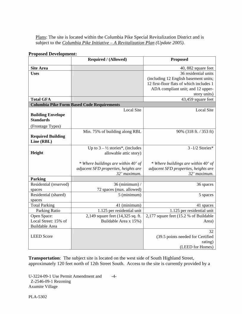
Plans: The site is located within the Columbia Pike Special Revitalization District and is subject to the Columbia Pike Initiative – A Revitalization Plan (Update 2005).
Proposed Development: Required / (Allowed) Proposed
Site Area 40, 882 square feetUses 36 residential units
(including 12 English basement units; 12 first-floor flats of which includes 1
ADA compliant unit; and 12 upper-story units)
Total GFA 43,459 square feetColumbia Pike Form Based Code Requirements
Building Envelope Standards (Frontage Types)
Local Site Local Site
Required Building Line (RBL)
Min. 75% of building along RBL 90% (318 ft. / 353 ft)
Height Up to 3 – ½ stories*, (includes
allowable attic story)
* Where buildings are within 40’ of adjacent SFD properties, heights are
32’ maximum.
3 -1/2 Stories*
* Where buildings are within 40’ of adjacent SFD properties, heights are
32’ maximum. Parking Residential (reserved) spaces
36 (minimum) / 72 spaces (max. allowed)
36 spaces
Residential (shared) spaces
5 (minimum) 5 spaces
Total Parking 41 (minimum) 41 spaces Parking Ratio 1.125 per residential unit 1.125 per residential unit Open Space: Local Street: 15% of Buildable Area
2,149 square feet (14,325 sq. ft. Buildable Area x 15%)
2,177 square feet (15.2 % of Buildable Area)
LEED Score 32
(39.5 points needed for Certified rating)
(LEED for Homes) Transportation: The subject site is located on the west side of South Highland Street, approximately 120 feet north of 12th Street South. Access to the site is currently provided by a

U-3224-09-1 Use Permit Amendment and -5- Z-2546-09-1 Rezoning Axumite Village PLA-5302
driveway on South Highland Street. The Master Transportation Plan – Part I, classifies South Highland Street as a Non-Arterial Urban Local Center Street which currently has two north and southbound travel lanes and on-street parking. The alignment of S. Highland Street, north of this site, will be changed in the future with redevelopment creating an off-set intersection with 11th Street to the north of the subject site. The purpose of this alignment change is to improve overall connectivity across Columbia Pike and a traditional 4-legged intersection will be created. The existing 11th Street South will be extended west and will ultimately provide frontage for the units (27) on the north side of the site. A temporary access easement for emergency vehicles will be provided on the west end of the site until such time that the extension of 11th Street S. is constructed. Street and Sidewalks: The subject site has frontage along South Highland Street. The following Table I, lists the street classifications as identified in the Master Transportation Plan.
Table I. Master Transportation Street Classifications
Street Classification Travel Lanes
Bike Access Restricted Access Pkg
On-street Parking
Pedestrian Access
Minimum Sidewalk Widths
South Highland Street
Type-C Arterial
4 + Turning Lane
Bike Lane No Yes 12 ft. s/w 6 ft clear
Future 11th Street
Non-Arterial Urban Center Local
2 Bike/Shared Lane
No Yes 12 ft. s/w 6 ft clear
The streetscape and cross sections are consistent with the adopted standards and meet the minimums as required by the Master Transportation Plan. The following describes the streetscape for each of the streets that abut the site. South Highland Street: Classified in the Master Transportation Plan as a Non-Arterial Urban Local Center Street, South Highland Street currently exists with two (2) travel lanes, and accommodates on-street parking. South Highland Street travels north and south and has an approximate width of 35 feet. The applicant proposes to construct a 19-foot-wide sidewalk measured from the required building line to the back of curb, which includes tree pits. 11th Street: The site will be developed with frontage only on South Highland Street. A new section of 11th Street S. is planned for the future and will provide frontage for the northern portion of the site. The Master Transportation Plan identifies 11th Street S as a Non-Arterial Urban Local Center Street which will include one (1) eastbound and one (1) westbound travel lane measuring approximately 33 feet. The applicant proposes to construct a 19-foot sidewalk

U-3224-09-1 Use Permit Amendment and -6- Z-2546-09-1 Rezoning Axumite Village PLA-5302
from the required building line to the back of curb with tree pits. Construction of 11th Street South in this location is dependent upon the redevelopment of surrounding properties; therefore, until that occurs, the units facing 11th Street will have sidewalk access only. Parking and Loading: The applicant is providing on-site and on-street parking. The applicant proposes 37 on-site parking spaces and four (4) on-street spaces on the north side of the site. The four on-street parking spaces will be counted towards meeting the shared parking requirements, as permitted under the FBC. In addition, these four spaces will be designed with access from S. Highland Street, during the interim conditions which preclude their arrangement as standard on-street parallel parking spaces. All other parking is located off of the alley, within the block’s interior. Pedestrian Circulation: The applicant proposes pedestrian circulation by providing contiguous sidewalk around the perimeter of the site. A 19-foot sidewalk with a minimum six (6) feet of clear sidewalk will be maintained along the perimeter of the site. Public Transit: The site is served on site by ART Bus #41 along South Highland Street and the #16 Metrobus service along Columbia Pike, which is one block to the north. The #16 Metrobus provides connections to the Pentagon and Pentagon City Metrorail stations as well as service directly into Washington, DC. Bicycle Access: The Form Base Code describes the minimum parking requirements for the site. For residential development, one (1) tenant bicycle parking rack or bicycle locker (2-bike capacity) per three (3) units and one (1) visitor bicycle parking rack (2-bike capacity) per 50 units. The developer has agreed to provide 13 bicycle racks on-site and 3 on-street meeting the requirement. Emergency Vehicle Access Easement: The site will be accessed by emergency vehicles from S. Highland Street and the alley. However, the site does not provide adequate area for emergency vehicles to properly turn around or exit the site. Therefore, the Fire Marshal indicates that without a dedicated turn-around on the property, the proposal could not be constructed without an off-site easement for emergency vehicle ingress and egress. The Fire Marshal’s standard precludes vehicles from backing out of a dead-end space for a distance greater than 150 feet. In this case, the alley will be a dead-end condition until redevelopment occurs on the adjacent parcel, and the alley length exceeds 150 feet. Therefore, the applicant proposes to meet the Fire Marshal’s requirements by utilizing an emergency vehicle access easement on the adjacent commercial property to the west that would be used solely by emergency vehicles for ingress or egress during fires, or other life-threatening situations. The access easement would begin at the western end of the proposed alley and extend across the adjacent property to connect to a public right-of-way (see Attachment 1). The County, the applicant, and the adjacent property owner and lessee are in discussions on the subject emergency vehicle easement. If the applicant’s proposal is approved by the County Board, staff recommends that construction of the project be

U-3224-09-1 Use Permit Amendment and -7- Z-2546-09-1 Rezoning Axumite Village PLA-5302
conditioned to obtaining and recording an emergency vehicle access easement (see Condition #44). The easement would be in effect until such time that alternative access for emergency vehicles can be provided, presumably when 11th Street South is constructed and continues further to the west of this site, with a connection to Glebe Road, or another alternative solution that meets the Fire Marshal’s requirements. Utilities: Adequate water system capacity will be provided to serve the development. Approximately 125 feet of existing 6-inch water main will be replaced with 8-inch water main along the South Highland Street frontage. Two new fire hydrants and three water meters will also be installed by the developer. DISCUSSION: Located within the “Columbia Pike Special Revitalization District”, as shown on the General Land Use Plan, the subject site is eligible for redevelopment under the Columbia Pike Form Based Code, with the appropriate zoning. However, the property must first be rezoned from “R-5” One Family Residential District to another district that specifically permits use of the FBC (Section 20 – Appendix A). The applicant is requesting a rezoning to the “CP-FBC” Columbia Pike – Form Based Code District (Section 20). When the FBC was originally adopted, the County Board instituted a rezoning process for “R” zoned properties seeking to develop under the FBC. This was established to provide an additional step in the review process and to ensure that properties seeking development under the FBC can reasonably meet the FBC regulations and that the development will be compatible with the adjacent properties. In this case, the subject site is sufficiently sized to accommodate the required street dedication, an alley, and implement a design that is in keeping with the Local Site Building Envelope Standards. Rezoning to the “CP-FBC” is preferred as this district was specifically established for the Columbia Pike Revitalization District and requires any development to follow the FBC regulations. The proposed rezoning to “CP-FBC” is consistent with the adopted plans and policies for the area and the change in zoning will enable a small redevelopment project, a type that has not been proposed much to date, to further the County’s revitalization efforts for the Columbia Pike corridor. This project would also provide for the expansion of homeownership opportunities in the area. Pursuant to the Form Based Code, the proposal is subject to use permit approval by the County Board due to the overall site size, which exceeds 40,000 square feet, and because of the applicant’s request for approval of some modifications to the FBC. The Regulating Plan (map) of the FBC specifies which Building Envelope Standards (BES) apply to each property, and specifically establishes the parameters for how the street frontage shall be built. The BES sets forth regulations pertaining to building height, building placement, and permitted uses on parcels within the District. The FBC also specifies where open space is to be built or maintained. In this case, the subject site has been designated with the Local Site BES designation for both the S. Highland Street and future 11th Street frontages. The Local Site

U-3224-09-1 Use Permit Amendment and -8- Z-2546-09-1 Rezoning Axumite Village PLA-5302
frontage calls for a maximum building height of 3-1/2 stories. However, any buildings within 40 feet of an abutting single-family property must not exceed a height limit of 32 feet, as measured to the bottom of the eaves or to the top of the parapet. This property is adjacent to single-family detached dwellings and, therefore, the proposal is affected by this requirement. For this Local Site, the applicant proposes 12 condominium townhouse structures, with three (3) residential units per structure for a total of 36 units. A combination of first floor flats, 2 and 2-1/2 story upper-story units, and English basements are proposed. The 12 townhouses are clustered into 3 blocks, one facing S. Highland Street and two facing 11th Street. Nine (9) units will face S. Highland Street, and the remaining 27 units will face 11th Street. The townhouses will vary from 3 to 3-1/2 stories, with the half-stories set back 12 feet from the required building line, per the FBC. One end unit along S. Highland Street is located within 40 feet of the abutting single-family dwelling. Therefore, for a portion of the structure, the building height has been limited to 32 feet, meeting the requirement. The buildings are situated on the RBL, occupying approximately 90% of the frontage, exceeding the minimum 75% requirement. The required open contiguous lot area is located to the rear of the units and the areas between each grouping of buildings, excluding the recessed yards accessible from the English basement units. Street walls are proposed, consistent with the FBC, where the open space fronts on the RBL. Parking is provided off the alley in a surface parking area. Although affordable housing is not a requirement under the FBC, the applicant proposes that approximately two-thirds of the units will be available for sale at prices below market rates. The applicant is in discussion with County housing staff regarding our Moderate Income Purchase Assistance Program (MIPAP) to make a portion of the total units affordable to households from 60% to 80% AMI (Annual Median Income). Staff expects the applicant to submit an application for a reservation of MIPAP funds in July with a subsequent request for Board action in September or October. At this time, the conditions do not require these units to be affordable. During the course of the review of this proposal, the applicant has continually refined the site and building layout and architectural treatments of the project to better comply with the FBC regulations. Staff has concluded that the proposed project and the architectural renderings attached are in compliance with the Form Based Code, with the exception of three areas where modifications are requested, and finds that the proposal is consistent with the goals of the Columbia Pike Initiative – A Revitalization Plan (Update 2005) Modifications: The applicant requests three types of modifications with this proposal: 1) to modify the location of the rear alley; 2) to modify one element of the Streetscape regulations, narrowing the street tree pit widths along 11th Street South; and 3) to modify sign regulations to place address signs at a height of approximately 12 feet above the adjacent sidewalk grade rather than at a height between 8 and 10 feet as specified by the FBC, and to include a project identification sign in the landscaped area at the corner of 11th Street and S. Highland St.

U-3224-09-1 Use Permit Amendment and -9- Z-2546-09-1 Rezoning Axumite Village PLA-5302
• Alley: Unless shown on the Regulating Plan, an alley is required within the rear setback
and shall provide access to the rear of all lots by definition under the FBC regulations. For this site, no alley is shown on the Regulating Plan therefore, the FBC text applies. The rear setback would be determined by the location of the rear lot line and, for a corner lot such as this, the rear lot line is considered to be the property line that is furthest from and most parallel to the shorter of the two front property lines (Highland St. and 11th Street). In this case, the shorter front property line is S. Highland Street, and the rear of the lot would, therefore, occur at the opposite property line along the western property line.
At this time, the western property line is not accessible from a street, therefore, creating an alley in this location would not provide access to the rear of the site and it would not connect to or from any adjacent lots in a meaningful manner. If the alley were created there, a drive aisle would be needed from Highland Street to access the alley. Under the FBC, the County Board may modify the location of alleys and place the required alley elsewhere on the site when unusual circumstances preclude the FBC requirements from being implemented in a feasible, functional, and appropriate manner and when it finds that an alternative placement may better meet the intent of the FBC. Therefore, the applicant is requesting an alternative alley location to better meet the intent of the FBC and to provide an alley that would have more connectivity in the future. The proposed location is approximately 23 feet from the southern property line and connects to S. Highland Street. The alley location could connect to an alley on the adjacent property to the west and eventually to Glebe Road in the future when redevelopment occurs which would be beneficial to provide one, connected alley for what will be similar shaped lots, south of the proposed 11th Street. In order to meet the parking requirements for this site, the applicant proposes to shift the alley away from the southern property line, approximately 23 feet, and to use the alley to access the 37 proposed surface parking spaces. The parking spaces flank both sides of the alley, which serves dual purposes in this case as both an alley and as a drive aisle. Staff has evaluated the proposed alley location and finds that it reasonably meets the intent of the FBC requirements as it provides access to the rear of the property, in a location behind the proposed buildings and at least 25 feet away from the S. Highland Street and 11th Street South RBLs. During the preliminary review phase, staff recommended appropriate parking and drive aisle dimensions to the applicant to meet County policies and standards. Also, staff recommends that a surface access easement be placed over the alley to allow for public access and has indicated this in Condition #23.
• Streetscape Element: Under the FBC, a number of streetscape requirements are specified, including the dimensions for tree pits and overall tree pit size in area. The minimum dimension in any one direction is 5 feet, and the overall minimum tree pit area

U-3224-09-1 Use Permit Amendment and -10- Z-2546-09-1 Rezoning Axumite Village PLA-5302
is 60 square feet. Along the site’s frontages (11th Street and S. Highland St.), the applicant proposes to reduce the minimum tree pit dimension from 5 feet to 4 feet. This proposed reduction is needed to accommodate the minimum 6-foot-wide clear walkway and the space needed for the required stoop and stairs associated with each unit’s main entrance from the sidewalk. However, the tree pit length is proposed to increase from 12 feet to 14 feet in order to maintain the total area of at least 60 square feet. Although the 5 foot dimension is less that the minimum requirement, staff supports the modification because the overall tree pit size is maintained, and the four foot dimension has been used elsewhere where site conditions have not allowed for a wider tree pit size. In the future, staff may reexamine the typical street cross sections that were developed for the side streets along the Pike corridor to determine if any further adjustments are needed to avoid having this narrower tree pit condition duplicated on other streets where stoops and stairs are required. Staff will continue to work with the applicant at the time of Landscape Plan review and approval to determine the most beneficial tree planting techniques in these areas (See Condition #14).
• Signs: The applicant requests modifications to the FBC regulations for two types of
proposed signs. First, the applicant requests that the address signs, “house” numbers, be placed at a point higher on the front elevation than permitted by the FBC. The FBC requires address signs to be located a minimum of 8 feet and a maximum of 10 above grade. In this case, with the first floor entrances elevated per the FBC regulations and to accommodate English basement units, the applicant requests that the address signs be placed at a point that is approximately 12 feet above the adjacent sidewalk grade. This height will allow the addresses to be placed within the transom windows above the main entrance doors. Staff supports this modification as it is in keeping with the overall architectural design of the project and typical of a traditional row house style.
In addition, the applicant proposes a project identification sign to recognize the historical ancient city of Axum, Ethiopia which inspired the applicant’s residential proposal. The applicant proposes a sign placed in the landscaped area in front of the corner units at 11th Street and S. Highland Street. This sign, attached to the main building wall by a low, stone wall, would project approximately 7 feet above grade as a two-sided corton steel sign with the project name “Axumite Village” and logo. While the FBC allows for a building name sign (designed as a metal plaque up to 8 square feet in size) placed near the cornice line of a building, that type of sign may be more appropriate for a mixed-use multi-story building, rather than a smaller scale, townhouse form such as this. In addition, the FBC regulations permit freestanding signs with County Board approval. While the sign is not fully a free-standing sign, it connects to the ground in similar manner. The overall sign is approximately 28 square feet. Staff supports the proposed sign as it is in keeping with the architectural details proposed for the site and its location is outside of pedestrian traffic therefore avoiding any common conflicts commonly associated with freestanding signs.

U-3224-09-1 Use Permit Amendment and -11- Z-2546-09-1 Rezoning Axumite Village PLA-5302
Community Review Process: Pursuant to the FBC Administrative Regulations 4.1.2, once the applicant’s preliminary plans were substantially complete and compliant with the FBC, the applicant and staff met with the Columbia Pike Form Based Code Advisory Working Group (May 13, 2009) to review the plans with the FBC Checklist. Through this meeting, the AWG members asked questions about the project and the FBC regulations. Staff indicated that a few items were not yet compliant and that the design would need further refinement to be considered compliant with the FBC. The AWG members highlighted the proposed open contiguous lot area design and questioned whether the design met the FBC regulations since the recessed yards were included in the calculations. The applicant revised the design to remove the recessed yards from the open contiguous lot area in order to meet the minimum 15% FBC requirement. The AWG was generally supportive of the plans and were appreciative of the applicant’s persistence to pursuing development under the FBC. Also required by the Administrative Regulations 4.1.2, the applicant presented the plans at a community meeting on June 15, 2009. CPRO representatives and community members from the Douglas Park and Columbia Heights civic associations attended the meeting. The following questions and concerns were elevated:
• Confirm that the modified alley location does not have to be placed at the southern property line and that surface parking can be placed between the alley and the property line. Staff Response: Yes, the County Board can modify the final alley location which could be further from the adjacent property line and the FBC does not preclude the parking from occurring in the proposed location. The FBC specifically permits the location of alleys to be modified by the County Board. In this case, the alley location that is required by definition, along the rear lot line (western property line) would not be a location that could be accessed directly from an adjacent street, and would otherwise require a drive aisle from Highland Street to connect to the alley basically creating a new alley. Therefore the applicant requested to create the required alley parallel to the southern property line. The proposed location meets the intent of the FBC and the alley regulations by providing access to the rear of the lot behind buildings, access to parking and trash/storage areas, and at least 25 feet away from a Required Building Line (RBL). The FBC does not otherwise set limitations on where parking can occur on a site.
• Can the surface parking occur within the setback area?
Staff Response: Yes. Under the FBC, when a project abuts an existing single-family detached dwelling, the site’s Buildable Area is reduced to allow for an 8 foot wide setback. In this case, the southern portion of the site, along Highland Street abuts an existing single-family house, and therefore the Buildable Area for the lots fronting on the Highland Street RBL is at least 8 feet from the adjacent property line. Since the Buildable Area is also limited to a depth of 55 feet from the RBL, the area adjacent to the southern property line beyond 55’ from the Highland Street RBL is not technically

U-3224-09-1 Use Permit Amendment and -12- Z-2546-09-1 Rezoning Axumite Village PLA-5302
considered Buildable Area and therefore the setback regulation does not apply. Furthermore, parking areas may occur within a setback. Therefore, the proposed parking arrangement does not conflict with the FBC. The applicant proposes to maintain a landscaped area with shade trees, approximately 4’-9” wide, between the property line and the adjacent parking area. A 7-foot-tall privacy fence (solid wood or masonry) is required by the FBC along this property line and the applicant proposes a fence to meet this standard.
• Confirm how the applicant has met the required open contiguous lot area requirements.
Staff Response: Since the FBC AWG meeting on May 13, 2009, the applicant revised the design to reduce the rear, recessed yards in order to meet the 15 percent required open space within the Buildable Area of the site. The Buildable Area is that area that is within 55 feet from the Required Building Line, exclusive of the required alley and any setback area. In this case, the applicant deducted the alley area (23’) and the remaining landscaped area between the alley and the southern property line along S. Highland Street from the Buildable Area. This net Buildable Area measures approximately 14,325 square feet. The proposed open space runs along the rear of the townhouse units, south of the recessed yards, and connects to the areas between the three groupings of townhouses.
• Can the applicant provide an enhanced wall/fence treatment, taller than 7 feet, and constructed with materials better than wood, along the southern property line to mitigate the parking area proposed along that property line? Staff Response: The FBC does not allow modification of the privacy fence height therefore the height can not exceed 7 feet. Pursuant to feedback received during the Planning Commission public hearing, as described below, staff has revised Condition #8 to require the developer to collaborate with the immediate neighbors on the privacy fence design.
Planning Commission: The Planning Commission considered this item at its meeting on June 29, 2009 and voted 8-1-1 in support of the motion to approve the use permit. Overall, the Planning Commission members expressed support for the proposed project including its design and the applicant’s intent to provide affordable housing, although not required by the FBC. However, some Commissioners raised concerns with the requested modifications to move the alley location particularly related to its design, questioned whether other modifications, such as lowering the first floor height, could have been proposed to retain the required tree pit sizes, and expressed interest in ways to obtain community input sooner in the process when modifications are requested. Additionally, some Commissioners expressed concerns that they had insufficient information to verify staff’s conclusion that the project is FBC compliant. In order to indicate the level of compliance, staff has included a copy of the final FBC Checklist with this staff report (see Attachment 4), which had not be provided with the

U-3224-09-1 Use Permit Amendment and -13- Z-2546-09-1 Rezoning Axumite Village PLA-5302
Planning Commission report pursuant to prior practices when FBC projects had been reviewed in the past. Staff has concluded that the proposed alley location is suitable for the site and that, overall, it meets the intent of the FBC regulations. In addition, staff is recommending modification of the tree pit size rather than lowering the first floor level of the buildings because such a change would not likely be feasible and would cause conflicts with other FBC regulations, such as the clear height requirements for each floor, and certain building code requirements. Staff does not view the dimensional change to the tree pit sizes in this location to negatively impact the survivability of the street trees. In addition, the Commission made the following recommendations in its motion:
• Clarify who will be responsible for repairs and replacement if any damages occur to the street and/or streetscape areas and elements of 11th Street South built by this developer when future construction of the street by others occurs; Staff Response: If this project is built before other redevelopment projects are approved and built on the adjacent properties to the north, the applicant will only provide the streetscape and curb and gutter adjacent to the proposed buildings. Therefore, the developer for a future redevelopment project to the north will be responsible for construction of the majority of 11th Street South and will be responsible for tying into the established curb set by this project. Any damages made to the then-existing curb and streetscape would need to be repaired by the future developer, and/or replacements provided. In addition, as common practice, the County will approve and inspect this work to ensure that it is done properly and any damages, if any, will be corrected.
• During the permitting phase, work with the adjacent neighbors to determine a suitable
design for the privacy fence required along the southern property line and any proposed landscaping to provide further mitigation related to the adjacent parking area; and Staff Response: Once the applicant has proposed a design, staff can evaluate and coordinate with the applicant so that neighbors can review the proposal and provide feedback. Staff will work with the applicant at that time to evaluate the proposed privacy fence materials and landscape materials within the buffer space. This work would be done in advance of the approval of the final landscape plan, and language has been inserted into Condition #8 and #8.k. to ensure that this work is coordinated.
• During the permitting review phase, review the Lighting Plan and Final Landscape Plan
with the adjacent neighbors prior to the County Manager’s approval to confirm details and seek input on the final lighting and landscape details in the alley area. Staff Response: Condition # 8 and 39 have been modified to require the applicant to review these plans with the immediate neighbors and the Douglas Park Civic Association President, or representative, prior to the County Manager’s approval.
CONCLUSION: Staff concludes that the proposal meets the Columbia Pike Form Based Code regulations, with the exception of the requested modifications, and therefore, staff recommends

U-3224-09-1 Use Permit Amendment and -14- Z-2546-09-1 Rezoning Axumite Village PLA-5302
that the County Board approve the use permit request, subject to the use permit conditions attached to this report, and conditioned upon the Applicant obtaining and recording an easement from the adjacent property owner to the west as agreed to in Condition #44. The requested modifications meet the overall intent of the FBC.

U-3224-09-1 Use Permit Amendment and -15- Z-2546-09-1 Rezoning Axumite Village PLA-5302
REZONING RESOLUTION WHEREAS, the County Board of Arlington County ("County Board") finds that Ethiopian Community Development Council has requested a rezoning of properties located at 1036, 1100, and 1106 South Highland Street ("property") (RPC: #32-007-167, -168, and -022) from “R-5” One Family Dwelling Districts to “CP-FBC” Columbia Pike – Form Based Code Districts; and
WHEREAS, the County Manager has recommended approval of the rezonings to “CP-FBC” Columbia Pike – Form Based Code Districts; and WHEREAS, the Planning Commission of Arlington County held a duly advertised public hearing on the proposed rezonings on June 29, 2009 and recommended approval; and WHEREAS, the County Board of Arlington County held a duly advertised public hearing on the proposed rezonings on July 11, 2009. WHEREAS, the County Board finds that the rezonings to “CP-FBC” Columbia Pike – Form Based Code Districts will be consistent with the General Land Use Plan Designations for the Property; and WHEREAS, the County Board finds that the rezonings to “CP-FBC” Columbia Pike – Form Based Code Districts will achieve goals and objectives set forth in the Columbia Pike Initiative Land Use and Zoning guidelines; and
WHEREAS, the County Board finds that the rezonings to “CP-FBC” Columbia Pike – Form Based Code Districts is required by public necessity, convenience, general welfare, and good zoning practice; and NOW, THEREFORE, be it resolved, that the Property located at 1036, 1100, and 1106 S. Highland Street (RPC #32-007-167, -168, -022) is hereby rezoned FROM “R-5” One Family Dwelling Districts TO “CP-FBC” Columbia Pike – Form Based Code Districts, as shown on the attached map (Z-2549-09-1).
U-3224-09-1 Use Permit Amendment and -16- Z-2546-09-1 Rezoning Axumite Village PLA-5302
Axumite Village Proposed Conditions:
Note: Where a particular County office is specified in these conditions, the specified office includes any functional successor to that office. Where the County Manager is specified in these conditions, “County Manager” includes the County Manager’s designee. Whenever, under these conditions, anything is required to be done or approved by the County Manager, the language is understood to include the County Manager or his or her designee. The following Conditions of FBC Use Permit approval (#1 through #7) are valid for the life of the FBC Use Permit and must be met by the developer before issuance of the Clearing, Grading and Demolition Permit.
1. Use Permit Term
The developer (as used in these conditions, the term “developer” shall mean the owner, the applicant and all successors and assigns) agrees to comply with the standard conditions set forth below and the revised plans dated May 22, 2009 and reviewed and approved by the County Board and made a part of the public record on July 11, 2009, including all renderings, drawings, and presentation boards presented during public hearings, together with any modifications proposed by the developer and accepted by the County Board or vice versa. This Form Based Code Use Permit approval expires three (3) years after the date of County Board approval if a footing to grade permit has not been issued for the first building to be constructed pursuant to the approved plan. Extension of this approval shall be at the sole discretion of the County Board. The owner agrees that this discretion shall include a review of this Use Permit for a Form Based Code project and its conditions for their compliance with then current County policies for land use, zoning and special exception uses.
2. Pre-Construction Meeting The developer agrees to coordinate and conduct a pre-construction meeting in a County office building prior to the issuance of any permits for the site plan. The meeting participants shall include the developer and its construction team, and relevant County staff. Relevant County staff will include the following personnel and division representatives: DCPHD Columbia Pike Initiative Coordinator, Zoning Plan Review and Inspectors, Department of Environmental Services (DES) Transportation Planner, Landscape Plan team, and other departments as determined by the County Manager. The developer agrees to notify the above meeting participants of the meeting time and location at least two weeks in advance. The purpose of the pre-construction meeting is to discuss the requirements of the Use Permit conditions.
U-3224-09-1 Use Permit Amendment and -17- Z-2546-09-1 Rezoning Axumite Village PLA-5302
Plan for Temporary Circulation During Construction 3. The developer agrees to develop and implement (after approval) a plan for temporary
pedestrian and vehicular circulation during construction. This plan shall identify temporary sidewalks, interim lighting, fencing around the site, construction vehicle routes, and any other feature necessary to ensure safe pedestrian and vehicular travel around the site during construction. Exceptions may be made only during an emergency as defined below, during actual demolition, and for such limited periods as are unavoidable for utility upgrades. The developer agrees to submit this plan to, and obtain approval of the plan from, the County Manager as meeting these standards, before the issuance of the Clearing, Grading and Demolition Permit. The developer agrees to provide a copy of the approved plan to the appropriate civic associations. The County Manager may approve subsequent amendments to the plan, if consistent with this approval.
The developer agrees, during the hours of construction, to provide “flagmen” to assist in the direction of traffic along or around a street any time that any driving lane of such a street is partially or fully blocked due to temporary construction activities. In addition, the developer agrees to notify the appropriate civic associations and all abutting property owners in writing (or, by mutual agreement, by e-mail) at least seven calendar days in advance of any street closure, except in the case of an emergency, of more that one hour duration on any street. “Emergency” street closures may include, but not be limited to, those relating to rupture or potential rupture of a water or gas main, insecure building façade, or similar unforeseeable public danger. “Emergency” street closures shall not include closures for setting up or dismantling of a crane, exterior building construction, materials deliveries, or utilities work, or similar situations.
Where county street lighting has been removed or disconnected due to construction and not yet replaced or reconnected, the developer agrees to maintain lighting around the perimeter of the site between the start of construction and completion of the project. The lighting shall be designed to illuminate the temporary pedestrian walkways and roads around the perimeter of the site. The developer may do this by means of overhead lights (e.g. “cobra head” lights) that meet the lighting standards for Arlington County streets, or by stringing lamps of the kind used in “used car” lots or similar along sidewalks and streets along the perimeter of the site. If lighting is accomplished by the latter, such lighting shall be with 75 watt bulbs (or approximate equivalent) placed no more than 25 feet apart and 6 to 10 feet high. Lighting shall be turned on between dusk and dawn 7 days a week. Any high-intensity overhead lighting, such as lighting placed on construction cranes, shall be used only during construction hours (except lower levels after hours for safety and security reasons), and shall be placed so as not to directly illuminate residential dwellings or be a nuisance to neighboring property owners. For purposes of this condition, “completion of the project” shall mean the time when the

U-3224-09-1 Use Permit Amendment and -18- Z-2546-09-1 Rezoning Axumite Village PLA-5302
County standard lighting fixtures are in place and operational around the perimeter of the site. The developer agrees to maintain street surfaces adjacent to the site in a clean, smooth condition devoid of potholes at all times during the construction period. Whenever a significant portion of an adjacent road surface is disturbed for reasons relating to the construction, including utility work, the developer agrees to repair promptly the disturbed portion(s) of pavement with hot patching to return the road surface to a clean, smooth condition. The developer agrees to insure that the road surface is promptly repaired regardless of whether the excavation work or other damage to the road surface was done by the developer, the developer’s contractors, or private utility companies. The developer agrees to make reasonable efforts to schedule construction work so that digging in the street surfaces will not occur during the winter months. However, if the road surface is disturbed during the winter months, the developer may temporarily restore the road surface using cold patching and then hot patch the disturbed surface at the earliest opportunity when weather conditions permit. If cold patching is used, it shall be properly maintained and resurfaced as necessary to maintain a clean, smooth road condition. The term “significant portion of a road” is understood to include, but not be limited to, a cut in the road surface that exceeds 10 feet in length or 100 square feet in size. This condition is in addition to any other conditions in this site plan and any County requirements relating to reconstruction and repaving of streets at the completion of construction. Compliance with Federal, State and Local Laws
4. The developer agrees to comply with all federal, state and local laws and regulations not modified by the County Board's action on this Form Based Code Use Permit plan and to obtain all necessary permits. In addition, the developer agrees to comply with all of the agreed-upon conditions approved by the County Board as a part of this Use Permit approval. The developer specifically agrees that the County has the authority to take such actions as may be necessary, to include the issuance of a stop work order for the entire project, when the developer is not in compliance with the agreed-upon conditions. Further, temporary Certificates of Occupancy will not be issued without approval by the Zoning Administrator. Post-County Board 4.1.2 Filing
5. The developer agrees to file three copies of a Use Permit plan and the tabular information form, and digital copies on compact disc in JPEG, PDF, and DXF formats, which complies with the final approval of the County Board and with Administrative Regulation 4.1.2, with the Zoning Administrator within 90 days of the County Board approval and before the issuance of the Clearing, Grading and Demolition Permit.

U-3224-09-1 Use Permit Amendment and -19- Z-2546-09-1 Rezoning Axumite Village PLA-5302
The developer agrees to include on the post-4.1.2 plans details regarding existing traffic signal system infrastructure, e.g., poles, meters, controller cabinets, and to indicate on the plans if any part of the system will be moved and to where it is proposed to be moved. The developer agrees to convene and participate in a meeting with pertinent County staff to address requirements of the Use Permit approval, per Condition #2. The developer also agrees that no changes to the approved post-4.1.2 plans can take place in the field. All post-4.1.2 plan changes must be approved by the lead DCPHD contact for the Use Permit. Community Liaison and Activities During Construction
6. The developer agrees to comply with the following before issuance of the Clearing, Grading and Demolition Permit and to remain in compliance with this condition until the Master Certificate of Occupancy is issued. a. The developer agrees to identify a person who will serve as liaison to the community
throughout the duration of construction. This individual shall be on the construction site throughout the hours of construction, including weekends. The name and telephone number of this individual shall be provided in writing to residents, property managers and business owners whose property abuts the site, and to the Zoning Administrator, and shall be posted at the entrance of the project.
b. Before commencing any clearing or grading of the site, the developer shall hold a
community meeting with those whose property abuts the project to review the construction hauling route, location of construction worker parking, plan for temporary pedestrian and vehicular circulation, and hours and overall schedule for construction. The Zoning Administrator and the Arlington County Police representative must be notified once the community meeting dates/times are established. The developer agrees to provide documentation to the Zoning Administrator of the date, location and attendance of the meeting before a Clearing, Grading and Demolition Permit is issued. The developer agrees to submit to the Zoning Administrator two (2) sets of plans or maps showing the construction hauling route, construction worker parking and temporary pedestrian and vehicular circulation (one set of which will be forwarded to the Police). Copies of plans or maps showing the construction hauling route, construction worker parking and temporary pedestrian and vehicular circulation shall be posted in the construction trailer and given to each subcontractor and construction vehicle operator before they commence work on the project. The location of all construction trailers shall be approved either by Administrative Change approval or to be shown on the Tree Protection Plan, with the construction staging’s location and travel routes shown on a map approved as part of that plan. All trailers shall require approval by DES staff,
U-3224-09-1 Use Permit Amendment and -20- Z-2546-09-1 Rezoning Axumite Village PLA-5302
and the site plan’s Arlington County Police representative shall receive a copy of the aforementioned map.
c. Throughout construction of the project, the developer agrees to advise abutting
property owners, the Douglas Park and Columbia Heights Civic Association Presidents, and CPRO Executive Director in writing of the general timing of utility work in abutting streets or on-site that may affect their services or access to their property.
d. At the end of each work day during construction of the project, the developer agrees
to ensure that any streets used for hauling construction materials and entrance to the construction site are free of mud, dirt, trash, allaying dust, and debris and that all streets and sidewalks adjacent to the construction site are free of trash and debris.
e. The developer agrees that construction activity, except for construction worker
arrival to the construction site and indoor construction activity, will commence no earlier than 7:00 a.m. and end by 6:30 p.m. on weekdays and will commence no earlier than 10:00 a.m. and end by 6:30 p.m. on Saturdays, Sundays, and holidays. “Holidays” are defined as New Year’s Day, Martin Luther King Day, Presidents’ Day, Memorial Day, Independence Day, Labor Day, Columbus Day, Veterans’ Day, Thanksgiving, and Christmas. Indoor construction activity defined as activity occurring entirely within a structure fully enclosed on all sides by installed exterior walls, windows, and/or doors shall end at midnight each day, and any such activity that occurs after 6:30 p.m. shall not annoy or disturb reasonable persons of normal sensitivities. The developer agrees to place a minimum of one sign per street front around the construction site, indicating the permissible hours of construction, to place one additional sign within the construction trailer containing the same information, to provide a written copy of the permissible hours of construction to all subcontractors, and to require its subcontractors to observe such hours.
f. Storage of construction materials, equipment and vehicles shall occur on the site or an
approved off-site location, or as approved by the County Manager.
7. Vacations and Encroachments Prior to the issuance by the County of any permit for development of the Form Based Code Use Permit plan, except for demolition permits solely for buildings and structures neither owned by the County nor located on property within which the County has a n interest, the developer agrees to obtain approval of, and fulfill all required conditions of, all ordinances of vacation and/or ordinances of encroachment associated with and/or required to build the project, or any portion thereof, in accordance with the Use Permit plan referenced in Condition # 1 of this Ordinance and the final site engineering plans for the project approved by the County. Irrespective of any other conditions set forth herein,

U-3224-09-1 Use Permit Amendment and -21- Z-2546-09-1 Rezoning Axumite Village PLA-5302
the developer agrees that no building, structure or utility of any type shall encroach upon, or interfere with, the use of any County property or the exercise by the County of any property right or interest, unless and until the developer, before any Excavation/Sheeting and Shoring Permit is issued, first has: a) obtained an ordinance of vacation or an ordinance of encroachment, enacted by the County Board, permitting such use, encroachment or interference; and, b) met all of the conditions of such ordinance(s).
The following Conditions of Form Based Code Use Permit plan approval (#8 through #23) are valid for the life of the Use Permit and must be met by the developer before issuance of the Excavation/Sheeting and Shoring Permit.
8. Coordination of these plans: final site development, landscape and site engineering
The developer agrees to attach the County Board meeting minutes outlining the approved conditions and the conditions themselves to each set of Building Permit drawings that they submit to the County. The developer agrees to submit to the Zoning Administrator and obtain approval from the County Manager a detailed final site development plan and a landscape plan prior to issuance of the Excavation/Sheeting and Shoring Permit. The developer agrees to provide a copy of the final landscape plan to the immediate neighbors to the south of the property and to the Douglas Park Civic Association President, or his/her representative prior to the County Manager’s approval. The final site development plan and landscape plan shall be submitted at a scale of 1 inch = 25 feet, in conjunction with the final civil engineering plan as required in Condition #12 below, as well as a vicinity map with major streets labeled. The final landscape plan shall be developed by, and display the professional seal of, a landscape architect certified to practice in the Commonwealth of Virginia. The developer further agrees that the final landscape plan and the final civil engineering plan shall verify, by means of survey, that there are no conflicts between the street trees and utilities. The developer shall obtain approval by the County Manager for both plans as meeting all requirements of the County Board's Use Permit approval and all applicable county laws and plans before the issuance of the Excavation/Sheeting and Shoring Permit. The plan shall be consistent with the conceptual landscape plan approved as a part of the Use Permit plan, and, at a minimum, shall conform to: the landscaping requirements in Conditions #10 and 15 below; the Arlington County Streetscape Standards if applicable; the Columbia Pike Form Based Code; the County's landscaping, planting, and sidewalk and driveway construction specifications; and/or other applicable urban design standards approved by the County Board. In order to facilitate comparison with the final civil engineering plan, the landscape plan shall be at a scale of 1 inch = 25 feet; the County may require more detailed plans appropriate to landscape installation at a larger scale to also be submitted. The County may permit minor changes in building, street and driveway locations and other details of design as necessitated by more detailed planning and engineering studies if such changes are consistent with the provisions of the Zoning Ordinance governing administrative approval and with the intent of the Use Permit approval. The landscape

U-3224-09-1 Use Permit Amendment and -22- Z-2546-09-1 Rezoning Axumite Village PLA-5302
plan shall include a Street Tree Plan which shall be reviewed by DPRCR and DCPHD, and shall be accompanied by the civil engineering plan. All hardscape features shown on the approved landscape plan shall be completed prior to the issuance of the Shell and Core Certificate of Occupancy. All plant materials shown on the final landscape plan shall be installed before the issuance of the first Partial Certificate of Occupancy for any space above grade for the respective phase of construction, unless otherwise approved by the Zoning Administrator, based on the planting season and the availability of planting materials.
Upon approval of the final landscape plan and prior to the issuance of the first Certificate of Occupancy for the respective phase of construction, the developer agrees to submit to the Department of Community Planning, Housing, and Development (DCPHD) a copy of the contract for construction and installation of all landscape materials. The final landscape plan shall include the following details: a. The location and dimensions of traffic signal poles and control cabinets, utility
meters, utility vaults and boxes, transformers, mechanical equipment, fire hydrants, standpipes, storm water detention facilities, bus stops, the location of all existing and proposed utility lines and of all easements. The location of traffic control cabinets shall be shown on the final civil engineering plan and placed so they do not obstruct pedestrian travel or be visually obtrusive. Traffic control cabinets (existing or proposed) shall not be located in the pedestrian clear zone of the public sidewalk, including but not limited to access areas to ADA ramps, crosswalks, building entrances, and interior walkways. Transformers shall not be placed in any area designated as open contiguous lot area defined by the FBC, or other areas not permitted by the FBC. The developer agrees to relocate existing traffic signal poles, traffic signal cabinets, and any other existing traffic-related items and equipment located on, or in the public right-of-way contiguous to, the development site as described below. The improvements shall conform to the DES Construction Standards and Specifications, and shall be shown on the final engineering plan. Installation of the improvements shall be completed prior to issuance of the first certificate of occupancy for the development.
b. The location, dimensions, materials, and pavement pattern, where applicable, for
driveways and access drives, automobile drop-off areas, ADA ramps, driveway aprons, service drives, parking areas, interior walkways and roadways, plaza areas and sidewalks, as well as for address indicator signs. Interior walkways shall have a minimum width of five (5) feet. All plaza areas, access drives, automobile drop-off areas, interior walkways and roadways shall contain special treatments that coordinate in design, color and materials with the treatment of the public sidewalk.

U-3224-09-1 Use Permit Amendment and -23- Z-2546-09-1 Rezoning Axumite Village PLA-5302
The materials and colors used are subject to approval by the County Manager according to the Columbia Pike Form Based Code or other urban design standards approved by the County Board as a part of review and approval of the final landscape plan.
c. The location and types of light fixtures for streets, parking, walkway and plaza areas, and associated utilities, as contained in the lighting plan required in Condition #43 below.
d. Topography at two (2) foot intervals, and the finished first floor elevation of all structures, and top-of-slab elevation for any proposed underground structures.
e. Landscaping for open space areas, plaza areas, courtyards, raised planters (including cross-sections of raised planters), surface parking areas, and service drives, including a listing of plant materials; details of planting, irrigation and drainage; and details of proposed furnishings for all areas, including but not limited to dimensions, size, style(s), materials(s), finish(s) and manufacturer(s) of seating, bollards, trash receptacles, bike racks, arbors, trellises, and water features, and other landscape elements or structures. Include public art information, if known.
f. The location and planting details for street trees in accordance with Department of Environmental Services Standards and Specifications for planting in public rights-of-way and as shown on the final civil engineering plan.
g. The limits of demolition and construction.
h. Any overhang created by parking spaces located perpendicular to or abutting walkways shall not interfere with pedestrian movement on the walkway. The maximum overhang shall be three (3) feet and additional walkway shall be provided to accommodate the overhang.
i. Building roof drains shall connect directly to the underground water detention system
unless an alternative arrangement is approved by the County Manager on the final site development and landscape plan. In the case of an alternative arrangement, discharge of runoff shall be controlled to preclude sheeting of water onto sidewalks or patios.
j. Mechanical equipment shall be located and/or screened so as not to be visible from
public rights-of-way. The location of all transformers serving this site shall be approved by the County Manager as part of the final site development and landscape plan and shown on both the final landscape plan and the final site engineering plan.

U-3224-09-1 Use Permit Amendment and -24- Z-2546-09-1 Rezoning Axumite Village PLA-5302
k. Privacy walls shall be constructed of durable materials as specified by the Columbia Pike Form Based Code such as brick, cedar or redwood and are subject to approval by the County Manager on the final site development and landscape plan. All privacy walls adjacent to the public right-of-way and any other walls as required by the Columbia Pike Form Based Code County Manager shall be constructed consistent with the Columbia Pike Form Based Code of brick and shall not exceed a height of five and one-half (5 ½) feet above the adjacent sidewalk. All retaining walls shall be constructed of either masonry or brick and are subject to approval by the County Manager on the final site development and landscape plan. The developer agrees to collaborate with immediate neighbors to the south of the project and the Douglas Park Civic Association President, or his/her representative, on the privacy fence design in order to design a fence that is compliant with the Columbia Pike Form Based Code and adequately shields the adjacent properties from vehicular lights and minimizes noise from the parking area. The applicant also agrees to include landscape plantings along the southern property line between the fence and the parking areas to provide additional buffering for vehicular lights and noises and to discuss these details with the neighbors. The developer agrees to provide documentation to the Zoning Administrator on the meeting (s) with the neighbors, including a list of attendees and meeting notes.
The developer agrees that once approved, the final landscape plan shall govern construction and/or installations of elements and features shown thereon, except as amendments may be specifically approved through an Administrative Change request. Landscape Standards
9. The developer agrees that all landscaping shall conform to Department of Environmental Services Standards and Specifications and to at least the following requirements: a. Plant materials and landscaping shall meet the then-current American Standard
for Nursery Stock, and shall also meet the following standards: (1) Major deciduous trees (shade or canopy trees such as Oaks, Maples,
London Plane Trees, Japanese Zelkovas, etc.) other than street trees–a minimum caliper of 4 to 4 1/2 inches, except as indicated in Condition #14 below.
(2) Evergreen trees (such as Scotch Pines, White Pines, Hemlocks, etc.)–a minimum height of 7 to 8 feet.
(3) Ornamental deciduous trees (such as Cherries, Dogwoods, Serviceberries, Hornbeams, etc.)–a minimum caliper of 3 to 3 1/2 inches. Multi-stem trees shall not be less than 10 feet in height.

U-3224-09-1 Use Permit Amendment and -25- Z-2546-09-1 Rezoning Axumite Village PLA-5302
(4) Shrubs–a minimum spread of 18 to 24 inches.
(5) Groundcover–in 2 inch pots.
b. The developer agrees to coordinate with the DPRCR Urban Forester to determine an appropriate and acceptable season in which to conduct planting. The developer also agrees to notify the DPRCR Urban Forester at least 72 hours in advance of the scheduled planting of any street trees in the public right-of-way and to be available at the time of planting to meet with staff of DPRCR to inspect the plant material, the tree pit and the technique of planting. Soil used in the tree pit must meet the specifications for street tree planting available from the DPRCR Urban Forester. Planting is to occur during a season so as to best ensure the viability of the plantings. In addition, the developer agrees to plant trees prior to issuance of the first Certificate of Occupancy Permit. The developer also agrees to fulfill the Public Improvement Bond requirements (Condition #27).
c. All new lawn areas shall be sodded. All sod shall be state certified.
d. Exposed earth not to be sodded shall be well-mulched or planted in ground cover.
Areas to be mulched may not exceed the normal limits of a planting bed.
e. Soil depth shall be a minimum of four (4) feet plus 12 inches minimum of drainage material for trees and tall shrubs and three (3) feet for other shrubs. This requirement shall also apply to those trees and tall shrubs in raised planters. Soil depth for raised planters shall be measured from the bottom of the planter to the top of the planter wall. The walls of raised planters shall be no higher than seat-wall height (2 1/2 feet, maximum) above the adjacent finished grade.
f. Finished grades shall not exceed a slope of three to one or the grade that existed before the site work began.
g. The developer agrees to maintain the site in a clean and well-maintained condition before the issuance of the Clearing, Grading and Demolition Permit and agrees to secure and maintain the site throughout the construction and phasing process. Further, the developer agrees to submit a maintenance agreement which shall ensure that all plaza areas and other landscaped areas located on private property are kept in a clean and well-maintained condition for the life of the site plan and to follow the terms of that maintenance agreement approved for that purpose by the Zoning Administrator, as required in Section 32A of the Zoning Ordinance.

U-3224-09-1 Use Permit Amendment and -26- Z-2546-09-1 Rezoning Axumite Village PLA-5302
Utility Company Contacts 10. The developer agrees to contact all utility companies, including the electric, telephone
and cable television companies, and offer them access to the site at the time of utility installation to install their underground cables. In order to comply with this condition the developer agrees to submit to the Zoning Administrator copies of letters from the developer to the utility companies offering them access as stated above for each phase of the project. The developer agrees to also contact the Development Services Bureau Chief, Transportation Division of the Department of Environmental Services in Arlington County not less than two (2) months prior to its planned commencement of utility undergrounding for each phase of the project to offer the County, at no cost to the County, access to the locations where the developer plans to excavate trenches or similar areas to install underground utilities so the County may install its fiber optic cable and\or conduit in those places concurrently with the developer’s utility installation. Such access, and the terms and conditions under which access to the site will be provided and the undergrounding activities of the County and the developer will be coordinated, shall be set forth in an agreement approved by the County Manager and the County Attorney. Final site engineering plan approval by DES
11. The developer agrees to submit final site engineering plans to the Department of Environmental Services. The plans shall include a receipt from the Zoning Office that the landscape plan has been accepted. Staff comments on the final engineering plans will not be provided to the developer without submission of the landscape plan to the Zoning Office. The plans shall be drawn at the scale of 1 inch = 25 feet and be 24 inches by 36 inches in size. Neither the Excavation/Sheeting and Shoring permit nor the first Building Permit shall be issued until final site engineering plans which agree with the approved final site development and landscape plans, and the sequence of construction, has been approved by the Department of Environmental Services and the CPHD Columbia Pike Coordinator, as consistent with all Use Permit approval requirements and all County laws. To ensure final sign-off, the plans shall include CPHD Columbia Pike Coordinator review and signature blocks. Upon completion of the construction of a project, the developer agrees to submit one (1) set of as-built mylar plans for sanitary, storm sewer and water main construction to the Department of Environmental Services for recording.
12. All sanitary sewers and water mains, including water services, shall have a minimum of
10-feet horizontal clearance from each other and 5-feet from all other utilities, and shall have a minimum of 10-feet horizontal clearance from buildings and other structures, or as approved by the County Manager or his designee. Water mains 16-inches and larger, and mains placed more than 10-feet below the surface shall have a minimum of 15-feet horizontal clearance from buildings and other structures; and sanitary sewers 15-inches and larger, or sewers placed more than 10-feet below the surface shall have 15-feet minimum clearance from buildings and other structures. All water mains and sanitary sewers shall meet County Standard design criteria.

U-3224-09-1 Use Permit Amendment and -27- Z-2546-09-1 Rezoning Axumite Village PLA-5302
Pavement, Curb and Gutter Along All Frontages
13. The developer agrees to show on the final engineering plans pavement, curb and gutter along all frontages of this site in accordance with the Columbia Pike Form Based Code, and/or the then-current Arlington County standards for concrete curb and gutter and the then-current standards for pavement and according to the following dimensions. The pavement, curb and gutter shall be constructed prior to issuance of the first Certificate of Occupancy for occupancy of the applicable phase of the project. a. The developer agrees to construct curb and gutter at a minimum distance of
approximately 18 feet (back of curb) from the survey centerline along South Highland Street as shown on the final site engineering plan as approved by the County Manager or his designee, and a 19-foot wide concrete sidewalk consisting of tree pits and 6-foot clear sidewalk.
b. 11th Street South: The developer agrees to construct curb and gutter at a minimum distance of approximately 18 feet (back of curb) from the survey center line along northern frontage of the property at the future 11th Street as shown on the final engineering plan as approved by the County Manager or his designee, and a 19-foot wide concrete sidewalk consisting of 4-foot wide tree pits and 6-foot clear sidewalk.
c. The developer further agrees to coordinate with the adjacent property owner to
construct 11th Street South to its ultimate design.
d. The developer agrees to construct handicap ramps along South Highland Street at the on-site and receiving corners of the intersections of 11th Street as shown on the final engineering plan approved by the County Manager.
e. The developer agrees to construct pedestrian crosswalks of materials as approved by
the County, built per Arlington County Standards, along South Highland Street at the intersections of South Highland Street and 11th Street, as shown on the final engineering plan approved by the County Manager
All improvements to curb, gutter, sidewalks and streets for pedestrian and/or vehicular access or circulation shall be in full compliance with the Americans with Disabilities Act (ADA) and any regulations adopted thereunder, as well as any other applicable laws and regulations. The developer further agrees that all improvements to curb, gutter, sidewalks, crosswalks, and streets for pedestrian and/or vehicular access or circulation shall be as determined by the County Manager on the final Site Development and Landscape Plan and on the final Site Engineering Plan, in accordance with the Columbia Pike Form Based Code Streetscape Standards or other applicable urban design standards in effect at the time of final Site Engineering Plan Approval; provided, however, that the

U-3224-09-1 Use Permit Amendment and -28- Z-2546-09-1 Rezoning Axumite Village PLA-5302
provision of such improvements shall not increase the projected cost anticipated for such improvements as shown on the Use Permit plan drawings dated May 22, 2009 and June 2009, unless otherwise amended at the time the County Board approves the project and unless the County provides additional funding to offset such increased cost.
14. Sidewalk Design and Improvements The developer agrees that the final sidewalk pattern/design and final selection of materials and colors to be used shall be as determined by the County Manager on the final landscape plan and final civil engineering plan, in accordance with the Columbia Pike Form Based Code Streetscape Standards. The clear pedestrian zone of all public sidewalks shall also be indicated. The sidewalk clear zones along the street frontages of this development shall be consistent with the Columbia Pike Form Based Code Streetscape Standards and shall be placed on a properly-engineered base approved as such by the Department of Environmental Services. The developer agrees that the clear pedestrian zone sidewalk shall: a. Continue across all alleys and any driveway aprons for loading and garage entrances
along all frontages of the Use Permit plan, and there shall be no barriers to impede the flow of pedestrian traffic.
b. Not be less than six feet wide at any point. c. Allow encroachments by sidewalk cafes only in accordance with Condition # 50 and
under the provisions of the Columbia Pike Form Based Code Streetscape Standards. d. Allow pinch-points only under the provisions of the Columbia Pike Form Based Code
Streetscape Standards. e. Use plain, un-tinted concrete or, subject to approval, an integral tint that harmonizes
with its setting. Non-standard materials or surface treatments may be used subject to approval by the Columbia Pike Administrative Review Team and under the provisions of the Columbia Pike Form Based Code Streetscape Standards.
f. Not contain joints or use patterns that create gaps of ¼-in depth or greater at spacings of less than 30.”
The developer further agrees to construct the sidewalk improvements detailed below prior to the issuance of the first Certificate of Occupancy for occupancy of the applicable phase of the project. The sidewalks shall contain street trees placed in either tree pits, tree grates or planting strips, consistent with the Standards for Planting and Preservation of Trees in Site Plan Projects, and as specified below. Placement, planting and root enhancement options shall be consistent with the Standards for Planting and Preservation of Trees in Site Plan Projects, and as specified below. Street trees shall not be placed within the vision obstruction area. All public walkways shall be constructed to County Standard. The

U-3224-09-1 Use Permit Amendment and -29- Z-2546-09-1 Rezoning Axumite Village PLA-5302
developer, or any subsequent owner, also agrees to maintain and replace the street trees and sidewalks for the life of the Form Based Code Use Permit. The sidewalk sections and street tree species shall be as follows: a. 11th Street South – a minimum 19-foot, wide sidewalk measured from the back of
curb maintaining a 6-foot wide clear sidewalk, including 4 feet by 14 feet tree pits placed at the back of curb, planted with 4 ½ inch caliper Red Oak street trees, or as otherwise approved by the Columbia Pike FBC Administrative Review Team at the time of final Landscape Plan approval, placed 25 to 30 feet on center.
b. S. Highland Street – a minimum 19-foot, wide sidewalk measured from the back of curb maintaining a 6-foot wide clear sidewalk, including 5 feet by 12 feet tree pits placed at the back of curb, planted with 4 ½ inch caliper Red Oak street trees, or as otherwise approved by the Columbia Pike FBC Administrative Review Team at the time of final Landscape Plan approval, placed 25 to 30 feet on center.
c. The developer agrees that all underground utilities and utility vaults shall not be
located in a manner that interferes with the appropriate spacing and replacement of street trees, consistent with the approved final site development and landscape plan. Utility lines shall not be located beneath street trees. The location of all existing and proposed utility lines shall be shown on both the final landscape plan and the final site engineering plan.
d. The developer agrees that if the County develops and/or revises the streetscape
paving and furniture standards in the adopted Columbia Pike Form Based Code prior to submission of the final site engineering plans, the streetscape paving and furniture standards shall be incorporated into the final site engineering plans.
Water Service Requirements
15. The developer agrees that the location of the water services will be determined at the time of the review of the final engineering plan, and shall be constructed in accordance with the standards defined in the Arlington County Department of Environmental Services Construction Standards and Specifications Manual. Existing Water Main or Fire Hydrant Service
16. The developer agrees that no existing water main or fire hydrant shall be taken out of service or made inaccessible without the prior approval of the Department of Environmental Services. This approval shall be obtained before the issuance of the Excavation/Sheeting and Shoring Permit.

U-3224-09-1 Use Permit Amendment and -30- Z-2546-09-1 Rezoning Axumite Village PLA-5302
Replacement of Damaged Existing Curb, Gutter and Sidewalk 17. The developer agrees to remove and replace, according to the Arlington County
Department of Environmental Services Construction Standards and Specifications Manual, any existing curb, gutter and sidewalk along the street frontages of this site which is in poor condition or damaged by the developer, prior to the issuance of the first Certificate of Occupancy for tenant occupancy of the building. Street Lighting Requirements
18. The developer agrees to show on the final engineering plans street lighting along all frontages of the site prior to the issuance of the Excavation/Sheeting and Shoring Permit. The plans shall include the height and color of the street light poles. The developer agrees, at its cost, to purchase and install approved Arlington County street lighting along the frontages of the site prior to the issuance of the Shell and Core Certificate of Occupancy. In addition, the developer agrees to furnish and install all conduit and junction boxes necessary for the lighting system. All construction shall meet Arlington County standards. The developer agrees to purchase and install "Carlyle" standard street lights along all frontages of the site in accordance with the Columbia Pike Form Based Code. The developer agrees to remove all standard thoroughfare lights from the site, unless the County decides that one or more are required to provide adequate lighting for street safety purposes at intersections. The developer agrees to pay the cost of moving existing or installing additional standard thoroughfare lights if required above.
Underground Existing Aerial Utilities
19. The developer agrees to remove or place underground all existing aerial utilities within or along the periphery of the entire Use Permit site as shown on the final site development and landscape plan and the final engineering plan approved by the County Manager. Any utility improvements necessary to provide adequate utility services to this development or utility work necessary to provide a terminus to the underground facilities shall be paid for by the developer and shall not result in the installation of any additional utility poles, or aerial devices. The developer agrees to also contact the Development Services Bureau Chief, Transportation Division of the Department of Environmental Services in Arlington County not less than two (2) months prior to its planned commencement of utility undergrounding for each phase of the project to offer the County, at no cost to the County, access to the locations where the developer plans to excavate trenches or similar areas to install underground utilities so the County may install its fiber optic cable and\or conduit in those places concurrently with the developer’s utility installation. Such access, and the terms and conditions under which access to the site will be provided and the undergrounding activities of the County and the developer will be coordinated, shall be set forth in an agreement approved by the County Manager and the County Attorney. All utility relocation shall be completed prior
U-3224-09-1 Use Permit Amendment and -31- Z-2546-09-1 Rezoning Axumite Village PLA-5302
to the issuance of the Shell and Core Certificate of Occupancy. The developer agrees that this condition does, and shall not be construed to grant, to the developer, any rights or permissions for the developer to install utilities and related facilities underground within any land in which the County has a property interest, unless the developer first obtains from the County all approvals and permissions which authorize such installation(s). Off-street Parking for Construction Workers
20. The developer agrees to provide off-street parking for all construction workers without charge to the workers. In lieu of providing parking, the developer may provide a subsidy for the construction workers in order that they may use Metro, provide a van for van pooling, or use another established method of transportation to provide for construction workers to arrive at the site. Compliance with this condition shall be determined based on a plan which shall be submitted to the Zoning Administrator, and for which the developer has obtained the Zoning Administrator’s approval, before the issuance of the Excavation/Sheeting, and Shoring Permit. This plan shall set forth the location of the parking to be provided at various stages of construction, how many spaces will be provided, how many construction workers will be assigned to the work site, and mechanisms which will be used to encourage the use of Metro, carpooling, vanpooling, and other similar efforts. The plan shall also provide for a location on the construction site at which information will be posted regarding Metro schedules and routes, bus schedules and routes, and carpooling and vanpooling information. If the plan is found to be either not implemented or violated during the course of construction, a correction notice will be forwarded to the developer. If the violation is not corrected within ten (10) days, a "stop work order" will be issued, and construction halted until the violation has been corrected. Construction vehicles and/or construction worker vehicles are not permitted to park on the neighboring streets during the hours of construction. The developer also agrees that all construction traffic shall enter and leave the site using South Highland Street. Address Indicator Signs
21. The developer agrees to install address indicator signs on the site which comply with Section 27-12 of the Arlington County Code or successor provision in a location visible from the street and as shown on the final site development and landscape plan. Façade Treatment of Buildings
22. The developer agrees that the design of the facade treatment for the buildings and the materials to be used on the facades shall be as specified and shown on the submitted drawings identified in Condition #1 and as presented to the County Board and made a part of the public record on the County Board date identified in Condition #1, including all renderings, drawings, and presentation boards presented during public hearings. The developer agrees to submit colored drawings and renderings which label the materials

U-3224-09-1 Use Permit Amendment and -32- Z-2546-09-1 Rezoning Axumite Village PLA-5302
and colors for each elevation of the building, including interior elevations (e.g. elevations adjacent to interior courtyards, plazas and access drives), and material samples, for review by the County Manager for consistency with this Use Permit plan approval prior to the issuance of the Footing to Grade Permit. The developer further agrees to obtain the approval of the County Manager of the façade treatment as being consistent with the County Board approval before the issuance of the Final Building Permit. In addition, the developer agrees to: a. Place all vents on the interior wall of the adjacent balconies, where possible, or
otherwise away from view along facades along the Required Building Lines; b. Explore the use of newer technologies to reduce the height of the mechanical
penthouse, and provide cladding that is compliant with the Columbia Pike Form Based Code and similar in texture and color to the other exterior façade elements and materials.
Recordation of Deeds of Public Easements and Deeds of Dedications
23. The developer agrees that, all required plats, deeds of conveyance, deeds of dedication, and deeds of easement associated with, and/or required by the final approved site engineering plans, for the construction of any public street or sidewalk, alley, public infrastructure, public utility, public facility or public improvement (jointly “Public Improvements”), shall be: a) submitted by the developer to the Department of Environmental Services for review prior to the issuance of any Excavation/Sheeting and Shoring Permit for the project that is the subject of this Use Permit; and; b) approved by the County Manager, or his designee, as to substance and the County Attorney, as to form; and c) recorded by the developer, among the land records of the Circuit Court of Arlington County, all before the issuance of the first Certificate of Occupancy for tenant occupancy of the building(s) or any portion. Real estate interests conveyed by the developer to the County for public street or public right-of-way purposes shall be conveyed in fee simple, free and clear of all liens and encumbrances. Real estate interests conveyed by the developer to the County for Public Improvements or public uses, including, but not limited to, sidewalk, street trees, other streetscape planting, water mains, storm sewers, sanitary sewers, and other public utilities and facilities, which other Public Improvements are not located, or to be located, in the public street or public right-of-way may be granted to the County by deed(s) of easement, provided, however, that in the deed(s) conveying such real estate interests to the County, all liens and encumbrances shall be subordinated to the easement rights of the County. In addition to any other easements or dedications that may be otherwise required by this Use Permit, the developer, its successors in interest and title and assigns agrees to make the following conveyances and dedications, the deeds for which shall comply with the requirements of the above paragraph in this Condition #23 unless otherwise specifically provided below:

U-3224-09-1 Use Permit Amendment and -33- Z-2546-09-1 Rezoning Axumite Village PLA-5302
a. To grant and convey, to the County Board, an easement for public street and utilities
purposes, approximately 3,867 square feet in area, running from the northern property boundary of the property upon which the Use Permit is located (“Property”) to the face of curb being constructed as part of this Use Permit for the future 11th Street South, and as such area and face of curb are further shown on a plan entitled, “Exhibit A Showing Proposed Street Dedications and Easements”, dated July 1, 2009 (“Plan”) (see Attachment 2), and determined on the final approved engineering plan for the Use Permit. The developer further agrees to perform and pay for the continued care, cleaning, maintenance, including snow and ice removal, repair, replacement, installation and removal of any roadbed, roadway, pavement, curbs, signage, pavement marking, street trees and other landscaping, benches, trash receptacles, bicycle racks, lighting, sidewalk paving, fire hydrants, parking meters, and other similar facilities (collectively “Facilities”) located in the easement area and the above described easement area until such time as the developer dedicates the above described area to the County Board in fee simple as provided in subsection (c) below. To the extent that parking on the site is removed or decreased below what is required by zoning as a result of any dedication pursuant to this condition (33.a.), such non-compliance shall not affect the use permit which shall be treated for all purposes as a legal, nonconforming use, pursuant to Section 35.E.
b. Prior to the issuance of the first Certificate of Occupancy for tenant occupancy of the
building(s) or any portion thereof, to dedicate in fee simple to the County Board, for public street and utility purposes, an area which is approximately 4,3220 feet in width, running from the face of curb being constructed as part of this Use Permit for the future 11th Street South to a line which is located at the edge of the required 6-foot wide clear sidewalk closest to the Required Building Line along future 11th Street South and South Highland Street to the southern property line and as shown on the Plan. After dedication in fee simple, the developer agrees to continue to perform and pay for the continued care, cleaning, maintenance, including snow and ice removal, repair, replacement, installation and removal of the Facilities (as defined in subsection a. above) and the area located within the portion of the dedicated area containing the sidewalk.
c. To grant and convey, to the County Board, an easement for public access and utilities
purposes, an area which is is shown as the alley on the Plan and approximately 23 feet in width connecting from the right of way dedicated in fee simple as described in subsection c. above for South Highland Street to the western property line, and to dedicate easements for public sidewalks and utilities purposes for the sidewalks connecting from the alley to the 11th Street South 6-foot wide clear sidewalk described in subsection c. above and as further shown on the Plan. The developer, its successors in interest and title and assigns, agrees that it shall perform, and that the
U-3224-09-1 Use Permit Amendment and -34- Z-2546-09-1 Rezoning Axumite Village PLA-5302
deeds for the public access and utilities purposes for the alley and for the easement for public sidewalk and utilities shall include, among other things, provisions for the following:
i. The developer may provide and install Facilities (as defined in subsection a.
above) in the public sidewalk and utilities easement area outlined herein, if such Facilities are shown on the final engineering and final landscape plans for the Use Permit and are approved by the County Board as to number, type and location. Such Facilities shall remain the property of the developer.
ii. At its sole cost and expense, the developer shall perform and pay for the continued care, cleaning, maintenance, including snow and ice removal, repair, replacement, installation and removal of the areas of the public access and utilities easement, as shown on the Plan, for the areas of the public sidewalks and utilities easement shown on the Plan and for all Facilities (as defined in subsection a. above).
iii. To indemnify and hold harmless the County Board, its elected and
appointed officials, officer, employees and agents from any liability, personal injury, death, claims, damages, losses, costs and expenses of whatsoever nature, concerning or arising out of the design, construction, installation, care, cleaning, maintenance, repair, use, access, regulation, repair and removal of the areas of the public access and utilities easement (for the alley) as shown on the Plan and for the areas of the public sidewalks and utilities easement as shown on the Plan and any Facilities (as described in subsection a. above) contained therein.
d. At such time that either: 1) the County Board approves a redevelopment proposals for
either of the adjacent properties to the north (RPC # or RPC #), or 2) either the County Board or the County Manager determines that it is desirable for the County to construct 11th Street South adjacent to the Property and provides written notice to the developer of such determination, then the developer agrees to dedicate (including recordation of a deed in form acceptable to the County Attorney and in substance to the County Manager) in fee simple to the County Board within 120 days after either the approval or the notice, for public street and utilities purposes, approximately 3,687 square feet in area, running from the northern property boundary of the property upon which the Use Permit is located (“Property”) to the face of curb being constructed as part of this Use Permit for the future 11th Street South, as such face of curb is shown on plans entitled, “Exhibit B Showing Proposed Street Dedication”, dated July 1, 2009 (see Attachment 3), and as determined on the final approved engineering plan for the Use Permit,

U-3224-09-1 Use Permit Amendment and -35- Z-2546-09-1 Rezoning Axumite Village PLA-5302
The following conditions of site plan approval (#24 through #31) are valid for the life of the Form Based Code Use Permit plan and must be met by the developer before issuance of the Footing to Grade Structure Permit.
Plat of Excavated Area
24. The developer agrees to submit one (1) plat, drawn at the scale of 1 inch = 25 feet and 24 inches x 36 inches in size, of the excavated area showing spot elevations which confirm that the construction drawings are consistent with the average site elevation, and with the building’s ground floor elevation(s) at the building’s lowest level(s), as approved by the County Board and as indicated in the plans referenced in Conditions #1 and #6 above. Spot elevations shall be taken at spots determined at the time of the pre-construction meeting and shall at a minimum consist of two corners and spot elevations from 50 % of the total area to be excavated. The elevations shall be provided prior to the issuance of the footing to grade permit. Provided however, that when the Zoning Administrator determines that the excavated area will be greater than 20,000 square feet, the Zoning Administrator may reduce the area for which elevations must be provided before issuance of a footing to grade permit. Additional elevations confirming the elevations of the remainder of the excavation shall be provided prior to issuance of any permit for above grade construction. Public Improvements Bond
25. Upon approval of the final site engineering plan the developer agrees to submit a performance bond estimate for the construction or installation of all facilities (to include street trees and all landscape materials) within the public rights-of-way or easements to the Department of Environmental Services for review and approval. Upon approval of the performance bond estimate by the Department of Environmental Services, the developer agrees to submit to the Department of Environmental Services a performance bond, in the approved amount of the estimate, and an agreement for the construction or installation of all these facilities (to include street trees and all landscape materials) within the public rights-of-way or easements, which shall be executed by the developer in favor of the County before the issuance of the Final Building Permit. Prior to the release of the public improvement bond, the developer agrees to submit as-built drawings showing the location and facilities for all underground utilities (water, sanitary sewer, and storm sewer) that will be maintained by Arlington County. Trash Collection and Recycling Areas
26. The developer agrees that space off the alley, and outside of the required open contiguous lot area, shall be provided and used for the collection, storage, compaction, and removal of trash, as well as appropriate facilities for the recycling of reusable materials as defined by the County. The collection, storage, compaction, and removal of trash shall occur

U-3224-09-1 Use Permit Amendment and -36- Z-2546-09-1 Rezoning Axumite Village PLA-5302
within the alley and not within street rights-of-way. The developer agrees to indicate this area and any additional space needed to complete the necessary trash and recycling collection on the final site development, final landscape and final engineering plans.
Parking
27. The developer agrees to ensure that all parking spaces comply with the requirements of Section 33 of the Zoning Ordinance and the Columbia Pike Form Based Code and as shown on the drawings dated May 22, 2009. Unless otherwise approved by the County Board, the number of compact spaces may not exceed the Zoning Ordinance requirement. The developer shall submit drawings showing that these requirements are met, and shall obtain approval by the Zoning Administrator before the issuance of the Footing to Grade Structure Permit.
The developer agrees to construct 41 spaces as part of the development and agrees that up to 36 of these spaces may be reserved for residential occupants and at least 5 of these spaces shall be made available at all times to the public and visitors to the site on a non-reserved basis per the Columbia Pike Form Based Code. The developer agrees that 4 out of the 5 required non-reserved spaces will be constructed within the future 11th Street South right-of-way with access from S. Highland Street as shown on plans dated May 22, 2009 and further agrees that the four spaces will be relocated as on-street parallel parking spaces on 11th Street South once the area is dedicated to the County, per Condition #23, where the spaces will remain available for the public and visitors to the site on a non-reserved basis. The developers agrees to develop a parking management plan which outlines how guest and visitor parking and parking for residents, and general public parking will be provided, and where the parking will be located. The parking management plan shall also include the location of any secure areas, including bicycle storage, and the location of security gates or other measures to restrict access, if applicable. The parking management plan shall encourage parking by visitors of the project, through ease of access to the parking spaces, and signage. The developer shall submit the parking management plan to the Zoning Administrator and it shall be reviewed and approved by the County Manager prior to the issuance of the first Certificate of Occupancy for any portion of the site. Loading and Delivery Management Plan
28. Prior to the issuance of the first Certificate of Occupancy (to include temporary Certificates of Occupancy) for any building on the site, the developer agrees to submit a Loading and Delivery Management Plan to the Zoning Administrator for review and approval. This plan shall provide for service access using the public alley as shown in the plans dated May 22, 2009 and the final site engineering plan and located on South Highland Street. This plan shall further provide for monitoring of loading and

U-3224-09-1 Use Permit Amendment and -37- Z-2546-09-1 Rezoning Axumite Village PLA-5302
unloading/deliveries by the management, the restriction of loading and deliveries using public streets for the parking of loading and delivery vehicles and shall include a contact name of a person with authority to control loading and unloading/deliveries to whom outsiders may report violations. Bicycle Storage Facilities
29. The developer agrees to provide, at no charge to the user, secure bicycle storage facilities in locations convenient to office, residential and retail areas on the following basis at a minimum: Residential Bicycle Storage Facilities: One (1) resident bicycle parking rack (2-bike capacity) for every three (3) residential units, or portion thereof, of residential units and one (1) visitor rack (2-bike capacity) for every 50 residential units, or portion thereof, of residential units. All bicycle parking facilities are to be highly visible to users and protected from rain and snow within a lockable structure, with the exception of visitor/customer bicycle parking. The bicycle parking facilities shall not encroach on any area in the public right-of-way intended for use by pedestrians, nor shall they encroach on any required fire egress. Areas within the Open Contiguous Lot Area shall not be used for bike storage.
Multi-Space Parking Meters
30. Prior to the first Certificate of Occupancy, where parking meters currently exist along the site’s street frontages, the developer agrees to install either parking meters or multi-space parking meters, at the option of the County Manager. The developer agrees to coordinate with the County Manager’s designee to provide the new parking meters.
Emergency Vehicle Access/support on Parking and Alley Areas
31. The developer agrees to construct all alleys and all surface parking areas to support the live load of any fire apparatus. No above-grade structure shall be allowed to obstruct fire lanes. The requirements of this condition shall be incorporated in the drawings submitted for the Footing to Grade Structure Permit.
The following conditions of Form Based Code Use Permit plan approval (#32) are valid for the life of the Use Permit and must be met by the developer before the issuance of the Final Building Permit.
Screening of Mechanical Equipment
32. Mechanical equipment shall be screened so as not to be visible from public rights-of-way.

U-3224-09-1 Use Permit Amendment and -38- Z-2546-09-1 Rezoning Axumite Village PLA-5302
The following conditions of the Form Based Code Use Permit plan approval (#32 through #40) are valid for the life of the Use Permit plan and must be met by the developer before the issuance of the First Certificate of Occupancy.
Water Main Improvements
33. The developer agrees to show on the final engineering plans, and to construct, water main improvements in accordance with the standards defined in the Arlington County Department of Environmental Services Construction Standards and Specifications Manual as well as the following as outlined below. The water main improvements shall be constructed prior to the issuance of the first Certificate of Occupancy for the respective phases of construction. a. The developer agrees to replace approximately 125 feet of existing 6-inch water main
with 8-inch water main along the subject site’s South Highland Street frontage, from a connection to the existing 12 inch water main in 11th Street South, to a connection to the existing 6-inch water main at the southern boundary of the site. Two new fire hydrants and three appropriately sized water meters shall be installed by the developer from connections to the proposed 8 inch water main.
Sanitary Sewer Main Improvements
34. The developer agrees to show on the final engineering plans, and to construct, sanitary sewer main improvements in accordance with the standards defined in the Arlington County Department of Environmental Services Construction Standards and Specifications Manual. The sanitary sewer main improvements shall be constructed prior to the issuance of the first Certificate of Occupancy for the respective phases of construction. The County will TV-Inspect the sanitary sewer lines serving the site and shall identify any improvements that are necessary to adequately service the development. The developer agrees to repair or replace any sections or appurtenances of the sanitary sewer serving the development that are found to be deficient or damaged by the developer, as identified by County staff and as shown on the final engineering plan approved by the County Manager. Storm Sewer Improvements
35. The developer agrees to show on the final engineering plans, and to construct, storm sewer improvements in accordance with the standards defined in the Arlington County Department of Environmental Services Construction Standards and Specifications Manual as well as the following as outlined below. The storm sewer improvements shall be constructed prior to the issuance of the first Certificate of Occupancy for the respective phases of construction.

U-3224-09-1 Use Permit Amendment and -39- Z-2546-09-1 Rezoning Axumite Village PLA-5302
Fire Hydrant Requirements 36. The developer agrees to show on the final engineering plan, and to install, fire hydrants at
intervals of not more than 300 feet, as well as fire department connections in order to provide adequate fire protection. The County shall specify the kind of service and locations at the time of the final site engineering plan approval based on applicable safety standards. The fire hydrants and fire department connections shall be installed prior to the issuance of the first Certificate of Occupancy. The developer agrees to provide calculations to demonstrate the needed fire flow as defined in the Arlington County Department of Environmental Services Construction Standards and Specifications Manual. This information shall be clearly shown on the cover sheet of each final engineering plan set submitted.
Comprehensive Sign Plan
37. The developer agrees to develop and submit a comprehensive sign plan to the Zoning Administrator and that all exterior signs (including identification and directional signage) shall be consistent with the regulations contained within the Columbia Pike Form Based Code (Section 20. – Appendix A of the Zoning Ordinance), with the following modifications: a. Address signs shall be permitted to be 11-13 feet from grade instead of from 8’ – 10’
from grade, as shown on the plans dated May 22, 2009; and b. Permit the project identification sign at the corner of 11th Street and S. Highland
Street, as shown on the plans dated May 22, 2009, in lieu of a building name wall plaque that is otherwise permitted by the FBC.
All signs permitted by the modification of regulations shall be the size, location, and design shown on plans dated May 22, 2009. The Zoning Administrator shall determine whether the signs meet the Form Based Code regulations as modified. No sign permits will be issued until a comprehensive sign plan is approved by the Zoning Administrator as being consistent with the FBC sign regulations as modified above. The developer agrees to obtain approval from the Zoning Administrator of the comprehensive sign plan before the issuance of the Last Partial Certificate of Occupancy. Transportation Demand Management
38. The developer agrees to develop and implement a Transportation Demand Management Plan to be approved by the County Manager or his designee before the issuance of the first Certificate of Occupancy for any part of the development. The Transportation Demand Management Plan shall describe the developer’s efforts to implement, but not be limited to, the following strategies:

U-3224-09-1 Use Permit Amendment and -40- Z-2546-09-1 Rezoning Axumite Village PLA-5302
a. Provide SmarTrip cards plus $10.00 Metro fare media, 2 per unit, free of charge to the residents, at initial occupancy, to each residential lessee or purchaser, distributed no later than the day of move in.
b. Distribute a new-resident package, material provided by Arlington County, which
includes site-specific ridesharing and transit-related information to each residential lessee or purchaser. Packages will be distributed to tenants and / or owners no later than the day of move-in at the building.
Lighting Plan for Public Areas
39. The developer agrees to include a lighting plan for all internal and external public areas, including parking areas, as part of the final site development and landscape plan. This lighting plan shall be subject to review by the County Manager, including street lighting as described in Condition #18 above. Furthermore, the developer agrees that the lighting plan will be provided to the immediate neighbors and the Douglas Park Civic Association President, or his/her representative, for review and comment prior to the submission to the County and prior to the County Manager’s approval . The developer shall include in the site development and landscape plan certification that the lighting plan meets the minimum standards of the Zoning Ordinance, Section 2, Subsection H, and the Illumination Engineering Society of North America Standards and the Columbia Pike Form Based Code. The developer agrees to obtain the approval of all lighting from the County Manager, and to install approved lighting, before the issuance of the First Certificate of Occupancy for occupancy of the applicable phase of the project.
The developer agrees to install lighting in the rear alley in accordance with the Columbia Pike Form Based Code and show the alley lighting on the Lighting Plan, the final site development, final landscape, and final engineering plans. The developer further agrees to make all reasonable efforts to design and place any lighting in the alley or parking area in order to prevent lighting from shining directly into the adjacent neighbors properties and to provide a lighting plan that adequately provides necessary safety measures in the area. Availability of Use Permit Plan Conditions to Residential Condos, Cooperatives and Homeowners Associations
40. If the project includes a residential condominium or cooperative component, then the developer agrees that a copy of the conditions of this Use Permit plan approval shall be made available to all prospective purchasers with the condominium's, cooperative's or homeowners association's bylaws or agreements. Documentation that this condition has been satisfied shall be provided to the County Manager before the issuance of the First Certificate of Occupancy. If the project includes a residential rental component that is converted to a condominium or a cooperative, then the developer agrees that a copy of the conditions of this Use Permit plan approval shall be made available to all prospective

U-3224-09-1 Use Permit Amendment and -41- Z-2546-09-1 Rezoning Axumite Village PLA-5302
purchasers with the condominium’s, cooperative’s, or homeowners’ association’s bylaws or agreements prior to the issuance of the first Certificate of Occupancy following the conversion.
The following condition of FBC Use Permit plan approval (#41) is valid for the life of the Form Based Code Use Permit plan and must be met by the developer within 90 days of receipt of the partial Certificate of Occupancy for full occupancy of the building.
Obtain Master Certificate of Occupancy
41. The developer agrees to obtain a Master Certificate of Occupancy within 90 days of receipt of any partial Certificate of Occupancy for full occupancy of the building.
Post Certificate of Occupancy: the following Conditions of Form Based Code Use Permit plan approval (#42 through #43) are valid for the life of the Use Permit.
Snow Removal
42. The developer or owner agrees to remove snow from all interior streets, alleys and interior and exterior sidewalks, including accessibility ramps and gutter areas within crosswalks, within a reasonable time after snow has stopped falling but in no case later than snow removal provided for vehicular access to the site. Maintenance of Residential Common Areas
43. If the project includes a residential component, then the developer agrees that the maintenance of the common area, walkways, private drives and parking areas which are tied to condominium units shall be provided for by the condominium's, cooperative's or homeowners association's bylaws or agreements consistent with Section 2.D.6 of the Zoning Ordinance.
The following unique site specific condition (#44) is valid for the life of the Use Permit and must be met before the issuance of the permit specified in each Condition.
Emergency Vehicle Access Easement
44. The developer agrees that, prior to the issuance of any Clearing, Grading, and Demolition Permit for the project that is the subject of this Use Permit, the developer shall obtain and record an easement, running to the County Board, for emergency vehicle, fire and police vehicle access (“Easement”). Such Easement shall provide access from the subject property upon which this Use Permit is located (“Property” to a public right of way, across the property to the west of the site, RPC No. 32-007-014, which property presently is owned by Lucille B. Lambert and Bruce E. Lambert, deceased and ground leased to “Brown Automotive Group”. The Easement shall be at a location and of dimensions acceptable to the Fire Marshal and further shall be acceptable in substance to the County Fire Marshal and the County Manager, and subject to approval as to form to the County

U-3224-09-1 Use Permit Amendment and -42- Z-2546-09-1 Rezoning Axumite Village PLA-5302
Attorney. The developer further agrees that the Easement shall include, among other items, the following provisions:
a. The Easement shall provide fire, police and other emergency vehicle access over, across and through the Easement area twenty-four hours a day, seven days a week.
b. The Easement shall not terminate upon the earlier of: i) such time that a deed
conveying the County Board alternative ingress and egress for fire, police and other emergency vehicles to the Property is approved by the County Fire Marshal, accepted on behalf of the County Board and recorded in the Arlington County land records; or ii) the County Board enacts an ordinance vacating the Easement and such ordinance is effective.
c. The developer and the grantors of the Easement, their respective successors in
title and interest and their assigns, shall be responsible, at their sole cost and expense, to perform and pay for the continued care, cleaning and maintenance, including snow removal, repair, replacement installation and removal of the Easement area.
d. The developer and the grantors of the Easement, their respective successors in
title and interest and their assigns shall indemnify and hold harmless the County Board, its elected and appointed officials, officers, employees and agents from all liability, person injury, death, claims, damages, losses, costs and expenses of whatsoever nature, concerning or arising out of the design, construction, installation, care, cleaning, maintenance, repair, use access, regulation, repair and removal of the Easement by the developer, the County, the general public or the property owners.
e. The County may, but is not required to, regulate motor vehicle traffic, parking
and pedestrian traffic, within the Easement area and to install any signage and/or pavement markings to regulate the above or to indicate the Easement area.
The developer agrees to obtain the prior written approval of the Fire Marshal for the design and selection of any gates, barriers, bollards or other structures or facilities that may be proposed to be installed by the developer at the western end of the alley to restrict or block access to the Adjacent Property so that in the event that fire, police and other emergency vehicle access is needed, such gates, barriers, bollards or other structures or facilities can be immediately opened or removed by the County emergency, police or fire staff, without any liability or obligation whatsoever accruing to the County or the County staff. The developer further agrees, at its own cost and expense, to install, maintain,

U-3224-09-1 Use Permit Amendment and -43- Z-2546-09-1 Rezoning Axumite Village PLA-5302
repair, replace and remove any such gates, barriers, bollards or other structures or facilities that may be erected, removed or otherwise damaged.

U-3224-09-1 Use Permit Amendment and -44- Z-2546-09-1 Rezoning Axumite Village PLA-5302
PREVIOUS COUNTY BOARD ACTIONS: August 1961 Designated as “Low” Residential (0-8 units per
acre) on the General Land Use Plan. April 1975 Designated as “Low” Residential (1-10 units per
acre) on the General Land Use Plan November 15, 1986 General Land Use Plan amended to include the
Columbia Pike Special Revitalization District. Designated as “Low” Residential (1-10 units per acre).
December 17, 2002 Columbia Pike Special Revitalization District
boundaries amended on the General Land Use Plan. February 25, 2003 Columbia Pike Form Based Code (Section 20 of the
Zoning Ordinance) adopted. February 10, 2004 Columbia Pike Street Space Plan adopted and Form
Based Code amended to include new Required Building lines.