Arab Civil Aviation Commission ACAC CNS/ATM Study …Acao.org.ma/news/1467388708_2.pdfArab Civil...
158
Arab Civil Aviation Commission ACAC CNS/ATM Study Update & Strategic Planning (2015–2030) Draft Final Report Project Manager Raghu Reddy John Timmerman DeAnna Burke Task Team: Barbara Cogliandro Carolyn Cross Peter Hruz Mike Nash Contract: GCAA/DAF/PR/0241/020 30 June 2016 Airbus ProSky 45300 Catalina Court, Suite 101 Dulles, VA 20166 USA
Transcript of Arab Civil Aviation Commission ACAC CNS/ATM Study …Acao.org.ma/news/1467388708_2.pdfArab Civil...
Arab Civil Aviation Commission
ACAC CNS/ATM Study Update & Strategic Planning
(2015–2030)
Draft Final Report
Project Manager
Raghu Reddy
John Timmerman
DeAnna Burke
Task Team:
Barbara Cogliandro
Carolyn Cross
Peter Hruz
Mike Nash
Contract:
GCAA/DAF/PR/0241/020
30 June 2016
Airbus ProSky
45300 Catalina Court, Suite 101
Dulles, VA 20166 USA

Final Report: Proposed Format APS/Metron Aviation
ii
Revision Record
Revision Date Description
1.0 6/30/2016 ACAC CNS/ATM Study Update & Strategic Planning Draft Final
Final Report: Proposed Format APS/Metron Aviation
iii
Executive Summary
The Airbus ProSky ACAC Study Team wishes to thank Arab Civil Aviation Commission
(ACAC) for the opportunity to participate in the ACAC Communications, Navigation, and
Surveillance (CNS) /Air Traffic Management (ATM) Study Update & Strategic Planning (2015-
2030) Project efforts, and trusts that ACAC will find the Team’s efforts a meaningful
contribution to ACAC’s efforts to foster aviation in the Middle-East.
We particularly want to acknowledge the support the Airbus Middle-East provided in funding
the study.
The ACAC Team acknowledges that the success of its effort was in large part the result of the
willing and open cooperation and support of the ACAC state participants. We particularly want
to acknowledge the leadership and counsel provided by Mr. Hasan Alghorabi as Chairman of the
Air Navigation Committee (ANC) and Mr. Mohamed Rejeb as the ACAC focal point for the
project.
The final report addresses the study activities and analysis conducted in support of the Air
Navigation Committee since imitation of the study in May 2015.
Since the time of the previous study in 2004–2005, there have been significant changes in the
global approach to ATM and for aviation in the Middle East. Most notably for ATM is the
adoption of the International Civil Aviation Organization Global Air Navigation Plan (GANP),
development of the Aviation System Block Upgrade (ASBU) approach to ATM evolution,
implementation of formalised Safety Management System (SMS), and shifts in how Air
Navigation Services are provided. There has been and continues to be unprecedented rapid
growth of aviation in parts of the region that is straining ATM capabilities and spurring various
localised nation re-planning efforts.
Airbus ProSky and Airbus Mid-East agreed that a study would be extremely beneficial to the
region by addressing near-term and strategic ATM needs and requirements in the Middle East
and North Africa, and further agreed to conduct an updated study. Key drivers in that decision
were:
This region of the Middle East and North Africa has one of the highest air traffic growths
in the world with projections for sustained growth.
Some nations are already experiencing greater aircraft activity levels than ATM
capabilities and airspace route structures can and will be able to support.
Legacy operational agreements and procedures between nations lack the ability to
prevent oversaturating ATM capabilities of adjacent nation ATM facilities.
Operators like Emirates Airlines, Etihad Airlines, and Egypt Air have already expressed
concerns about limitation to airspace access and excessive delays.
Air Traffic Flow Management (ATFM) to assist in managing imbalance between demand
and available capacity will be significantly more effective in a larger regional application.

Final Report: Proposed Format APS/Metron Aviation
iv
With no immediate actions, the region is due to have numerous bottlenecks that will have
immediate effect on aviation growth, economic growth, safety, and the environment.
These shortfalls have direct impact on Air traffic growth.
While all ACAC states are expected to grow substantially through the period of time that the
GANP is to be implemented through the ABSU incremental approach, there are substantial
differences among the states in the current and expected density of air traffic. There are also
substantial differences in current capabilities and projected needs among the states; in essence,
“one size doesn’t fit all”. However, the interdependency of traffic flows in the region necessitates
a well-coordinated integrated approach to ensure both there are not gaps in capabilities as traffic
crosses state borders and that “ no country is left behind” as aviation advances in the Middle East
/ Norther Africa regions.
Further complicating achieving the needed capabilities and capacities across the region is that
aviation operations are being affected by economic and political challenges in several North
African and Middle East markets (Libya, Syria, Yemen and Iraq).
The ATM Study intent is to develop both near-term requirements and longer term strategic needs
to formulate a master plan for regional air navigation service provision through 2030. Included
will be a recommended systematic process to prioritise and balance investments aiming to
optimise ATM for the Arab Middle East and Northern Africa area.
The Air Navigation Service Providers (ANSPs) and civil aviation authorities have developed
strategic plans to address the growing needs. There are, however, substantial challenges in being
able to effectively accommodate the anticipated aviation growth and expectations of its
stakeholders. Some aspects of the current regional ATM system are already experiencing
extended periods of airborne holding or ground departure delays. The need to increase airspace
capacity, provide increased access to airports, improve efficiency for both aviation system
customers and ANSPs and reduce environmental impacts while continuing to maintain, foster,
and promote safety is paramount. Specific objectives to be highlighted in the Regional Concepts
for the year 2030 and transition from today’s system include:
1. Improve airspace safety and efficiency
2. Improve interoperability between ANSPs to foster seamless services across borders
3. Increase airspace capacity to meet future demand requirements
4. Increase access to airports
5. Reduce environmental impact of increasing traffic by providing improved ATM
operations
The initial scope of the study is defined as follows:
Time Scale: Traffic forecasting (traffic growth scenario for the coming 15 years) and
issues analysis is required for a 15-year time Horizon (2015 – 2030). The planning period
will be initially segmented between a 5 - year horizon through 2020 for identification of
near-term Global Best Practices recommendations and strategic reference of the regional
environment and needs in the 2025 and 2030 timeframes.
Final Report: Proposed Format APS/Metron Aviation
v
Key performance areas: The primary focuses of the planning process will be on safety,
capacity, airspace access, flight efficiency, routing flexibility, predictability, equity,
collaboration, interoperability, ensuring security and environmental impact and best value
solutions.
Geographically: The study will cover ACAC area (19 Arab States as illustrated in Table 1
(see section 2.1), but primarily only the regional aspect is to be considered. The national
aspect is included only as it pertains to cross border and regional ATM plans and
requirements.
During the performance of the study, challenges were encountered in obtaining data from some
of the ACAC member states. The difficulties in obtaining data continued into the spring of 2016
and were significantly affecting completion of the study. As a result, there was agreement to
proceed based on what data was available as of 18 March 2016, with accommodation of
information after that date to be done as practical.
During the Gap Analysis meeting, a decision was made to allow additional time to complete the
findings and recommendations with their targeted presentation by the ACAC CNS committee
moved from the June ACAC general meeting until the October meeting. It was agreed that the
schedule adjustment will provide the study team adequate time to complete the final report, for
the ACAC CNS Committee to provide feedback and for the Final report to be updated
accordingly. Section 3 contains a complete explanation of the project’s timetable and
adjustments.
The methodology and approaches used throughout the study were consistent with the SOW, and
include (1) work teams, (2) data identification and collection, (3) comparative analysis, and (4)
baseline ASBU Block descriptions.
The Airbus ProSky Team used an approach to the ATM Study necessitating a highly qualified
and diverse team of multi-discipline industry experts in not only studying aviation systems, but
with real world experience managing them and implementing major new capabilities and system
enhancements. The Airbus ProSky Team drew upon the expertise of its companies and Airbus
for world leading aviation expertise to form the core of the ATM Study Team.
While the Request for Proposal (RFP) outlined a study approach predicated on providing updates
to the previous study, the breadth of changes in the aviation environment and regional
environment would render such an approach to have only minimal benefit. As a result, Airbus
ProSky Team’s approach was to focus on both 2030 needs and the nearer term requirements that
could be realised by 2020 and 2025. The overall approach to the ATM Study is shown in Figure
10.

Final Report: Proposed Format APS/Metron Aviation
vi
Figure 10: ATM Study Approach
Key elements of the ATM Study included:
Establish reusable databases with data collected during the study from ANSPs and
involved / concerned stakeholders.
Provide an up-to-date picture of CNS/ATM developments and needs in the ACAC region
through 2030.
Link International Civil Aviation Organization (ICAO) GANP and relevant ASBU with
regional planning and individual State activities, to identify areas where ACAC could
look to coordinate harmonised ATM.
Identify gaps in CNS-ATM in the region, and set pragmatic objectives to build capability
to solve the issues identified.
Formulate solid recommendations to enable ACAC to enhance its coordination and
planning for the region, giving objective justification for regional initiatives by ACAC.
Support the implementation of the capacity and efficiency priorities such as PBN,
Continuous Descent Operations/Continuous Climb Operations (CDO/CCO), ATFM and
Aeronautical Information Management (AIM) as well as the regional air navigation
priorities defined in the Middle East region air navigation strategy
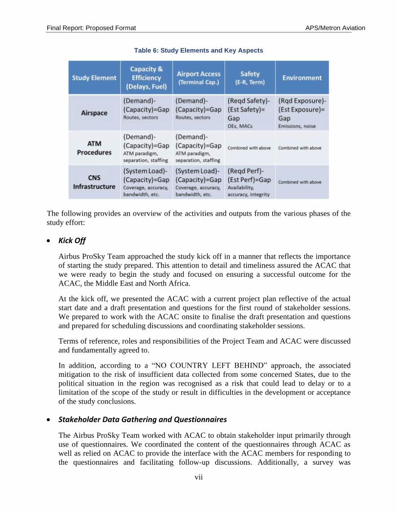
The Airbus ProSky Team methodology for the ACAC ATM Study was consistent with the
approach described earlier. Table 6 provides a depiction of the major study elements and key
aspects that were examined.
Final Report: Proposed Format APS/Metron Aviation
vii
Table 6: Study Elements and Key Aspects
The following provides an overview of the activities and outputs from the various phases of the
study effort:
Kick Off
Airbus ProSky Team approached the study kick off in a manner that reflects the importance
of starting the study prepared. This attention to detail and timeliness assured the ACAC that
we were ready to begin the study and focused on ensuring a successful outcome for the
ACAC, the Middle East and North Africa.
At the kick off, we presented the ACAC with a current project plan reflective of the actual
start date and a draft presentation and questions for the first round of stakeholder sessions.
We prepared to work with the ACAC onsite to finalise the draft presentation and questions
and prepared for scheduling discussions and coordinating stakeholder sessions.
Terms of reference, roles and responsibilities of the Project Team and ACAC were discussed
and fundamentally agreed to.
In addition, according to a “NO COUNTRY LEFT BEHIND” approach, the associated
mitigation to the risk of insufficient data collected from some concerned States, due to the
political situation in the region was recognised as a risk that could lead to delay or to a
limitation of the scope of the study or result in difficulties in the development or acceptance
of the study conclusions.
Stakeholder Data Gathering and Questionnaires
The Airbus ProSky Team worked with ACAC to obtain stakeholder input primarily through
use of questionnaires. We coordinated the content of the questionnaires through ACAC as
well as relied on ACAC to provide the interface with the ACAC members for responding to
the questionnaires and facilitating follow-up discussions. Additionally, a survey was
Final Report: Proposed Format APS/Metron Aviation
viii
developed and distributed to the Arab Air Carriers Organization (AACO) in an attempt to
gather more input from the customer perspective. Near the end of the data gathering effort,
the Airbus ProSky Team conducted a workshop with the ACAC members to review and
confirm the overall input received.
From the onset of this study update, stakeholder interaction and support have been identified
as two of the most critical factors in identifying and collecting the necessary data to
successfully advance this project. Realizing the project constraints (time and resources), the
project team supplemented ACAC Member State provided data with recently collected data
from regional ATC and ATM in support of a major UAE regional ATM airspace and
procedure redesign effort. This leveraging of information assisted the project team by
providing a highly detailed perspective of a segment of the overall ACAC jurisdictional
environment.
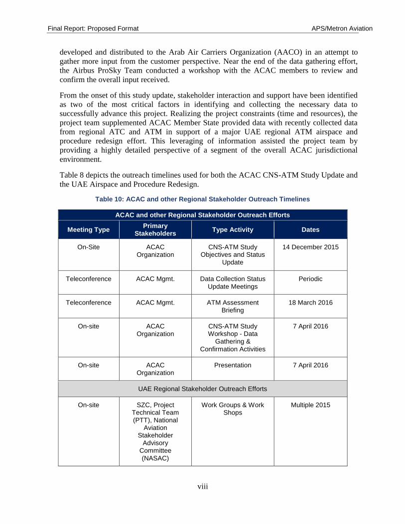
Table 8 depicts the outreach timelines used for both the ACAC CNS-ATM Study Update and
the UAE Airspace and Procedure Redesign.
Table 10: ACAC and other Regional Stakeholder Outreach Timelines
ACAC and other Regional Stakeholder Outreach Efforts
Meeting Type Primary
Stakeholders Type Activity Dates
On-Site
ACAC Organization
CNS-ATM Study Objectives and Status
Update
14 December 2015
Teleconference ACAC Mgmt. Data Collection Status Update Meetings
Periodic
Teleconference ACAC Mgmt. ATM Assessment Briefing
18 March 2016
On-site ACAC Organization
CNS-ATM Study Workshop - Data
Gathering & Confirmation Activities
7 April 2016
On-site ACAC Organization
Presentation 7 April 2016
UAE Regional Stakeholder Outreach Efforts
On-site SZC, Project Technical Team (PTT), National
Aviation Stakeholder
Advisory Committee (NASAC)
Work Groups & Work Shops
Multiple 2015
Final Report: Proposed Format APS/Metron Aviation
ix
ACAC and other Regional Stakeholder Outreach Efforts
Meeting Type Primary
Stakeholders Type Activity Dates
On-site SZC, DANS, ADAC, GCAA,
Data Gathering & Requirements Identification
Multiple 2015
On-site SZC, PTT Data Gathering & Requirements Identification
Multiple 2015
On-site SZC, Airbus ProSky
Development Activities Multiple 2015
On-site Bahrain Regional Data Gathering
24 March 2015
On-site Oman Regional Data Gathering
24 March 2015
On-site Qatar Regional Data Gathering
29 March 2015
Teleconference Saudi Arabia Regional Data Gathering
19 May 2015
On-site SZC, PTT Work Shop - Review, Affirmation and Advancement
Multiple 2015
A careful review was conducted of the data supplied, when it was received and searches for
all available public source data were conducted. As a result, judgments were required by the
contract team to determine which FIRs provided sufficient and effective data in order to be
able to conduct a timely and meaningful analysis. Erreur ! Source du renvoi introuvable.
depicts which States were included in the study and which were not as determined using the
criteria noted below:
Category 1 States - those States included in the study
Category 2a States - those States not included in the study due to data being
submitted beyond the March 18, 2016 cut-off date
Category 2b States - those States not included as they did not submit data
Table 8: State Study Inclusion Status
State Study Inclusion Status
Category 1 Category 2a Category 2b

Final Report: Proposed Format APS/Metron Aviation
x
State Study Inclusion Status
Category 1 Category 2a Category 2b
Algeria Oman Tunisia Iraq
Bahrain Palestine Mauritania Jordan
Egypt Qatar Kuwait
Lebanon Saudi Arabia
Libya
Morocco Sudan Syria
UAE Yemen
Section 5 Stakeholder Consultation contains an account of the responses obtained for both the
initial and supplemental questionnaires and the effectiveness of the data provided.
CNS/ATM Assessment
The Airbus ProSky Team leveraged their expert understanding of airspace, ATM procedures
and CNS infrastructure and demonstrated ability to work closely with diverse stakeholders to
assess the current and projected CNS and ATM capabilities in the Middle East and North
Africa. The Study team reviewed the available Aeronautical Information Publications (AIPs)
applicable to the ACAC States nations. The Airbus ProSky Team l also leveraged the
familiarity and recent presence and stakeholder interaction in the UAE and surrounding
countries to formulate stakeholder briefing and questions
The team relied heavily on the input of stakeholders using the team members’ earlier
experiences in the region as a reference point in compiling and analysing stakeholder input.
The assessments addressed a comprehensive breadth of airspace, ATM procedures and CNS
infrastructure aspects. The Airbus ProSky Team made assessments of current ATM
capabilities that will deliver accurate ATM procedures for safe, orderly, and efficient ATM
within the Middle East and North Africa while considering the needs/limitations of the
stakeholder community. A major element in conducting the assessment of the current
operation was to gather and compare the ICAO and Regional Sub-Group requirements and
guidelines as they pertain to the core operational topics of communication, navigation,
surveillance, automation, and air traffic management. These requirements and guidelines
were collected from sources which include: MIDeANP, CNS Sub Group Reports, GANP,
CANSO key performance indicators (KPIs), etc. The operational topics were further sub-
divided, although not uniformly and across all operational topics, into sections that included
categories:
1. General Regional Requirements
Final Report: Proposed Format APS/Metron Aviation
xi
2. Specific Requirements
3. Current Provided Services
4. Current Capabilities
5. Quality of Services
The specific assessments are contained in Section Erreur ! Source du renvoi introuvable.6
Assessment Process and Criteria.
In addition, the Airbus ProSky Team undertook an effort to categorize the FIRs to support
the concept of ‘one size does not fit all’ and is similar to the philosophy of the ICAO
Aviation System Block Upgrade methodology. The team categorized the FIRs into groups of
High, Medium and Low activity based on the current ACC and Aerodrome activity. This
methodology is fully explained in Section 7.
Gap Analysis and Findings
Key to a gap analysis was deciding on the points in time the gap will be assessed against. The
Airbus ProSky Team proposed to base the gap assessment on current capabilities and
compare those to ICAO Block Update 1, 2 and 3 capabilities and timeframes. The gap
analysis provided assessments in terms of the major element identified in the approach
section of the proposal as applicable to all phases of the study. In performing the gap
analysis, two factors were considered primary and not to be compromised; safety and
security.
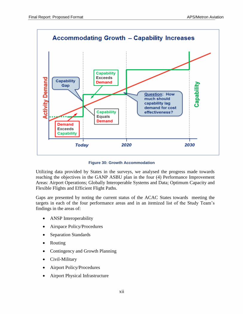
The Airbus ProSky Team evaluated gaps in capabilities to meet forecasted activity demand
and expected ABSU functionality using a need – capability model, as illustrated in Figure 30.
Final Report: Proposed Format APS/Metron Aviation
xii
Figure 30: Growth Accommodation
Utilizing data provided by States in the surveys, we analysed the progress made towards
reaching the objectives in the GANP ASBU plan in the four (4) Performance Improvement
Areas: Airport Operations; Globally Interoperable Systems and Data; Optimum Capacity and
Flexible Flights and Efficient Flight Paths.
Gaps are presented by noting the current status of the ACAC States towards meeting the
targets in each of the four performance areas and in an itemized list of the Study Team’s
findings in the areas of:
ANSP Interoperability
Airspace Policy/Procedures
Separation Standards
Routing
Contingency and Growth Planning
Civil-Military
Airport Policy/Procedures
Airport Physical Infrastructure
Final Report: Proposed Format APS/Metron Aviation
xiii
Traffic Flow Management/Collaborative Decision Making
The Study Team’s findings in current capabilities and services were primarily derived from
the surveys provided by the individual States plus a review of any internal documents that
were submitted by the States. Unable to conduct direct observation of the air traffic
operations resident in the participating States, the research team relied primarily on the
responses to the questions in the surveys, ICAO documents, and the very limited amount of
internal documentation that was provided. Web searches for detailed air traffic control
policies and procedures, as well as working practices, were attempted but yielded little result.
Those States that provided candid responses to the survey allowed the team the best
opportunity to attempt to assess the picture of the current state of the day to day air traffic
control operation. All of the findings listed in Section 9 apply to all assessed States based on
their existing and forecast traffic density. We also indicate if the finding is either directly or
indirectly linked to the Block Upgrade modules. Specific findings care located in sections
9.1.1 through Erreur ! Source du renvoi introuvable..
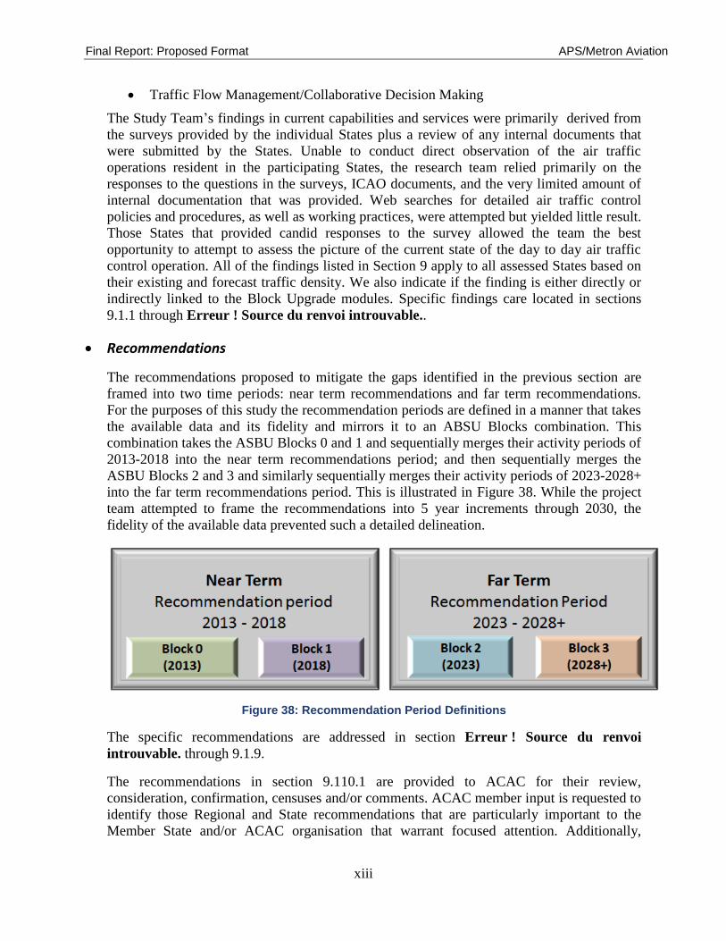
Recommendations
The recommendations proposed to mitigate the gaps identified in the previous section are
framed into two time periods: near term recommendations and far term recommendations.
For the purposes of this study the recommendation periods are defined in a manner that takes
the available data and its fidelity and mirrors it to an ABSU Blocks combination. This
combination takes the ASBU Blocks 0 and 1 and sequentially merges their activity periods of
2013-2018 into the near term recommendations period; and then sequentially merges the
ASBU Blocks 2 and 3 and similarly sequentially merges their activity periods of 2023-2028+
into the far term recommendations period. This is illustrated in Figure 38. While the project
team attempted to frame the recommendations into 5 year increments through 2030, the
fidelity of the available data prevented such a detailed delineation.
Figure 38: Recommendation Period Definitions
The specific recommendations are addressed in section Erreur ! Source du renvoi
introuvable. through 9.1.9.
The recommendations in section 9.110.1 are provided to ACAC for their review,
consideration, confirmation, censuses and/or comments. ACAC member input is requested to
identify those Regional and State recommendations that are particularly important to the
Member State and/or ACAC organisation that warrant focused attention. Additionally,
Final Report: Proposed Format APS/Metron Aviation
xiv
ACAC Organisational and State members are invited to provide supplementary
recommendations for analysis and inclusion.
Once the ACAC review period is complete, and input received, the project team will
aggregate and analyse the input to draw a series of key recommendations. The key
recommendations will inform ACAC of those areas where focused attention is required.
Final Report
The objective of this report was to provide ACAC with an assessment of the current state of
air traffic services in the Region defined by the ACAC membership. The current state of air
traffic services is a combination of the equipment capabilities currently available and how
they are being used. Therefore it is equally important to study the procedures and policies in
place in each ANSP in order to conduct a fair assessment. For this study we were limited to
the information provided by the ACAC member States and the information that the study
team could obtain from publically available sites. For the most part, detailed information
contained in the internal standard operating procedures for conducting day-to-day operations;
letters or memorandums of agreement with adjacent facilities; training plans; operations and
quality assurance metrics were not provided. Therefore the study team had to draw its own
conclusions regarding day to day air traffic operations from the very limited amount of
information contained in the two surveys provided to the ACAC States. Some of the surveys
were completed in their entirety including descriptions of impacts caused by inadequate
equipment capability or due to inherent air traffic procedures or flow management practices.
However many of the surveys did not reach this level of completeness. In those cases the
study team relied heavily on its own AT experience including that gained from having
conducted previous studies of operations in the Region to fill as many gaps in information as
possible.
We have itemized many near term and far term recommendations in Section 10. Those we
have designated as near term are recommendations we believe should be considered and
implemented as soon as possible. In High and Medium activity FIR’s these will enhance the
quality of air traffic services being provided today as well as help to mitigate impacts being
experienced today. For Low activity FIR’s incorporating these recommendations into their
operation today will help prepare them for the traffic increases forecasted for the area.
Paramount for the Region we believe are two equally important issues: first - is to achieve as
close to one hundred percent as possible interoperability among adjacent facilities in
information, data, and communications exchanges by creating interfaces where none exist
and maximizing those that do exist. Any hope for consistency in air traffic services or to
meet the forecasted air traffic demand in the Region is dependent upon this. Second - is to
ensure the equipment and capabilities present today are being utilized to the maximum extent
possible. For example, having the benefit of surveillance capabilities are diminished if
standard separation practices far exceed the minimum required in a radar environment.
We also believe it is important to the Region for all facilities to adapt the principals of traffic
flow management and they be incorporated into all ATC personnel training plans. Each
ANSP should assess for each facility within its area of jurisdiction the role of Traffic Flow
Management and determine who will provide the functions in the day to day operation. In

Final Report: Proposed Format APS/Metron Aviation
xv
some areas, we can see that the Traffic Flow Management functions should be conducted by
dedicated personnel while in other areas these functions can easily be assigned as an
additional duty with no loss of benefit. However, prior to expending resources on traffic flow
management equipment or personnel it is first important to conduct a complete assessment of
all agreements, airspace and procedures that may be contributing to the current impacts to air
traffic services. Traffic flow management is not a substitute for inefficient procedures or
airspace design.
This report can only be viewed as a beginning for the Region. We encourage a more
complete analysis of the operating procedures in each ANSP. Additionally we encourage the
development of Regional airspace redesign goals tied directly to safety and delay metrics.
We recommend these goals include standardized high altitude sector designs; creation of bi-
directional routings based on satellite navigation (while maintaining a limited amount of
ground based navigation routings for those aircraft lacking modern equipage); routes that
accommodate continuous descent and climb profiles and a fast track/slow track methodology
to alleviate bottle necks caused by differing aircraft operating characteristics.
Stakeholder and Executive Presentation
At the request of ACAC the Airbus ProSky Team will conduct the final report presentation to
ACAC and its leadership during the latter part of 2016.

Final Report: Proposed Format APS/Metron Aviation
xvi
ACKNOWLEDGEMENTS
The Airbus ProSky Study Team acknowledges the participation, support and collaboration of
the Arab Civil Aviation Commission and particularly the Air Navigation Committee
representatives. We particularly want to acknowledge the support the Airbus Middle-East
provided in funding the study. We would like to provide special thanks and recognition to
Mr. Hasan Alghorabi and Mr. Mohamed Rejeb for their project support, understanding and
operational insights.
Final Report: Proposed Format APS/Metron Aviation
xvii
Table of Contents
Executive Summary ..................................................................................................................... iii
Kick Off ........................................................................................................................................ vii
Stakeholder Data Gathering and Questionnaires ..................................................................... vii
CNS/ATM Assessment .................................................................................................................. x
Gap Analysis and Findings .......................................................................................................... xi
Recommendations ...................................................................................................................... xii
Final Report ............................................................................................................................... xiii
Stakeholder and Executive Presentation .................................................................................. xiv
ACKNOWLEDGEMENTS .....................................................................................................................xv
List of Figures ......................................................................................................................................... xx
List of Tables ........................................................................................................................................ xxii
List of Acronyms and Glossary ........................................................................................................... xxiv
1 Introduction ............................................................................................................................1
2 Background .............................................................................................................................2
2.1 ACAC Membership ...................................................................................................................... 3
2.2 ACAC Regional Description ........................................................................................................ 4
2.3 Traffic Growth .............................................................................................................................. 4
2.4 Problem Statement ........................................................................................................................ 6
2.5 Previous Related Work ................................................................................................................. 7
2.5.1 ACAC CNS-ATM Study ...................................................................................................... 7
2.5.2 UAE Airspace and ATM Study ............................................................................................ 7
3 Project Objectives, and Scope of Work ..............................................................................12
3.1 Project Objectives ....................................................................................................................... 12
3.2 Scope of Work ............................................................................................................................ 13
3.3 Deliverables ................................................................................................................................ 13
3.4 Timelines..................................................................................................................................... 14
3.5 Modifications to Timelines ......................................................................................................... 14
3.6 Risk Management ....................................................................................................................... 17
3.7 Identified Risks ........................................................................................................................... 17
3.8 Term of Reference, Roles & Responsibilities ............................................................................. 17
3.8.1 ACAC Roles & Responsibilities are: .................................................................................. 17
3.8.2 ACAC Project Manager of the CNS/ATM Roles & Responsibilities ................................ 17
4 Methodology/Approach........................................................................................................19
4.1 Project Work Team ..................................................................................................................... 20

Final Report: Proposed Format APS/Metron Aviation
xviii
4.2 Airbus ProSky Program and Technical Managers ...................................................................... 20
4.3 ACAC Project Team and Program Managers ............................................................................. 21
4.4 Key Study Elements .................................................................................................................... 21
4.5 Study Phases ............................................................................................................................... 21
4.5.1 Analysis Framework ........................................................................................................... 22
4.5.2 Stakeholder Coordination ................................................................................................... 22
4.5.3 ACAC Coordination ........................................................................................................... 23
4.6 Communications Plan ................................................................................................................. 23
4.6.1 Approach Rationale............................................................................................................. 24
4.7 Methodology ............................................................................................................................... 24
4.7.1 Study Phases ....................................................................................................................... 25
4.7.2 Final Report ........................................................................................................................ 31
4.7.3 Stakeholder and Executive Presentation ............................................................................. 31
5 Stakeholder Consultation.....................................................................................................32
5.1 Stakeholder Data Availability Impacts ....................................................................................... 34
6 Assessment Process and Criteria .........................................................................................38
6.1 Assessment Process .................................................................................................................... 38
6.1.1 Data Identification and Collection: ..................................................................................... 38
6.1.2 Data Processing: .................................................................................................................. 38
6.1.3 Data Assessment: ................................................................................................................ 39
6.2 Assessment Criteria: ICAO Technological and Procedural Requirements ................................. 40
6.2.1 Communications ................................................................................................................. 40
6.2.2 Navigation ........................................................................................................................... 45
6.2.3 Surveillance ......................................................................................................................... 50
6.2.4 ATM .................................................................................................................................... 53
6.3 Current Capabilities and Assessment .......................................................................................... 65
6.4 Current Capability ....................................................................................................................... 66
6.4.1 Communication ................................................................................................................... 67
6.4.2 Navigation ........................................................................................................................... 68
6.4.3 Surveillance and Automation .............................................................................................. 70
6.4.4 Air Traffic Management ..................................................................................................... 72
6.4.5 Air Traffic Flow Management ............................................................................................ 73
6.5 Safety .......................................................................................................................................... 76
6.5.1 Aviation Safety [2], [4] ....................................................................................................... 76
6.5.2 Airspace Safety Risk Classification [3] .............................................................................. 79
7 FIR Categorisation ...............................................................................................................82
Final Report: Proposed Format APS/Metron Aviation
xix
7.1 Airspace Size .............................................................................................................................. 83
7.2 Traffic Density (operations per sq. nm mile) .............................................................................. 84
7.3 Major Aerodrome Activities ....................................................................................................... 86
7.4 FIR Categorisation Determinations ............................................................................................ 88
8 Gap Analysis .........................................................................................................................90
8.1 Methodology ............................................................................................................................... 90
8.2 Gaps ............................................................................................................................................ 93
8.2.1 Status of ASBU Block 0 and Block 1 for Performance Improvement Areas 1-4: .............. 93
8.2.2 Status of ASBU Block 2 and Block 3 for Performance Improvement Areas 1-4: ............ 102
9 Findings ...............................................................................................................................106
9.1 Regional Findings ..................................................................................................................... 106
9.1.1 ANSP Interoperability ....................................................................................................... 106
9.1.2 Airspace Policy/Procedures .............................................................................................. 108
9.1.3 Separation Standards ......................................................................................................... 109
9.1.4 Routing .............................................................................................................................. 109
9.1.5 Contingency and Growth Planning ................................................................................... 110
9.1.6 Civil-Military .................................................................................................................... 113
9.1.7 Airport Policy/Procedures ................................................................................................. 113
9.1.8 Airport Physical Infrastructure .......................................................................................... 113
9.1.9 TFM/CDM ........................................................................................................................ 113
10 Recommendations ...............................................................................................................115
10.1 Near-Term & Far-Term Recommendations .............................................................................. 115
10.1.1 ANSP Interoperability ....................................................................................................... 115
10.1.2 Airspace Policy/Procedures .............................................................................................. 116
10.1.3 Separation Standards ......................................................................................................... 117
10.1.4 Routing .............................................................................................................................. 118
10.1.5 Contingency and Growth Planning ................................................................................... 118
10.1.6 Civil-Military .................................................................................................................... 118
10.1.7 Airport Policy/Procedures ................................................................................................. 119
10.1.8 Airport Physical Infrastructure .......................................................................................... 119
10.1.9 TFM/CDM ........................................................................................................................ 120
10.1.10 Other Dynamics ................................................................................................................ 121
10.2 Key Recommendations – Future Activity ................................................................................. 121
10.2.1 Key recommendation Summary (Text Format) ................................................................ 122
10.2.2 Key Recommendation Summary (Sample Table Format) ................................................ 122
11 References ............................................................................................................................123

Final Report: Proposed Format APS/Metron Aviation
xx
Appendix A: Regional Fleet Mix ........................................................................................125

Final Report: Proposed Format APS/Metron Aviation
xxi
List of Figures
Figure 1: ACAC Geographical Area....................................................................................................... 4
Figure 2: Middle East 2015 Traffic Increases......................................................................................... 5
Figure 3: World Aviation Mega-City Expansions (Source: Airbus Global Market Forecast
2015–2034) ................................................................................................................................. 6
Figure 4: Overview of Airspace Study Coordination and Interfaces ...................................................... 8
Figure 5: End Stage Statement ................................................................................................................ 9
Figure 6: Proposed Project Timeline .................................................................................................... 14
Figure 7: Project Timeline Variance as of December 2015 .................................................................. 15
Figure 8: Milestone Schedule ............................................................................................................... 16
Figure 9: Updated Milestone Schedule (May 2016) ............................................................................. 16
Figure 10: ATM Study Approach ......................................................................................................... 19
Figure 11: Work Project Team ............................................................................................................. 20
Figure 12: Data Delivery Flow Chart ................................................................................................... 27
Figure 13: Growth – Capability Model ................................................................................................. 29
Figure 14: Jurisdictional Overlap.......................................................................................................... 32
Figure 15: Category 1 and 2 State Illustration ...................................................................................... 37
Figure 16: Assessment Process ............................................................................................................. 39
Figure 17: ACAC Regional FIR PBN Planning (Source: ICAO Air Nav Report 2015 and
Surveys) .................................................................................................................................... 69
Figure 18: ACAC FIRs ADS-B-Out Capability (Source: Surveys, ICAO 2014) ................................. 72
Figure 19: ACAC FIRs ADS-C Capability (Source: Surveys, ICAO 2014) ........................................ 72
Figure 20: Middle East Homogenous Operating Areas (Source: MIDeANP) ..................................... 75
Figure 21: Middle East Homogenous Operating Areas (Source: AFI/MID ASBU WS) ..................... 75
Figure 22: AFTM Capability usage (Source: Surveys, ICAO 2014).................................................... 76
Figure 23: ACAC State Distribution among ICAO RASG Regions .................................................... 77
Figure 24: ACAC State Distribution Relative to Global Safety Implementation Averages................. 78
Figure 25: Percentage of Accidents and Fatalities per RASG Region ................................................. 79
Final Report: Proposed Format APS/Metron Aviation
xxii
Figure 26: Risk Category Illustration ................................................................................................... 80
Figure 27: ACAC Member State Illustration ........................................................................................ 83
Figure 28: ACAC Jurisdictional Airspace Comparison with Europe ................................................... 84
Figure 29: Illustration of Raw ACAC Jurisdictional Airspace Density Value Ranges 2015–
2030........................................................................................................................................... 85
Figure 30: Growth Accommodation ..................................................................................................... 90
Figure 31: ACAC ASBU Comparison Format ..................................................................................... 91
Figure 32: Regional Staffing Needs .................................................................................................... 107
Figure 33: Near-Far Term Homogenous Area Traffic Impacts .......................................................... 108
Figure 34: AR4 Middle East Homogenous Area Expansion .............................................................. 109
Figure 35: ACAC Regional ACC Forecast Near-Far Term................................................................ 110
Figure 36: ACAC Regional APC Forecast Near-Far Term ................................................................ 111
Figure 37: ACAC ANSP Facility Expansion Needs........................................................................... 112
Figure 38: Recommendation Period Definitions ................................................................................ 115

Final Report: Proposed Format APS/Metron Aviation
xxiii
List of Tables
Table 1: ACAC Member States .............................................................................................................. 3
Table 2: Key Recommendation Summary (Partial List)....................................................................... 10
Table 3: Deliverables Schedule ............................................................................................................ 13
Table 4: Stakeholder Engagement (as proposed) .................................................................................. 22
Table 5: Communications Plan ............................................................................................................. 23
Table 6: Study Elements and Key Aspects ........................................................................................... 25
Table 7: Enabling Technologies ........................................................................................................... 30
Table 8: ACAC and other Regional Stakeholder Outreach Timelines ................................................. 33
Table 9: State Study Inclusion Status ................................................................................................... 35
Table 10: FIR Data Response Status .................................................................................................... 36
Table 11: Cross-Reference Guide ......................................................................................................... 65
Table 12: Capability Definitions ........................................................................................................... 66
Table 13: Quality of Service Definitions .............................................................................................. 66
Table 14: RASG Accident Rate ............................................................................................................ 78
Table 15: RASG Traffic/Accident Comparison ................................................................................... 78
Table 16: Risk Category Assessments .................................................................................................. 80
Table 17: Categorisation Criteria by Activity ....................................................................................... 83
Table 18: Data Supporting Raw Density Values .................................................................................. 85
Table 19: Major Aerodrome Activities ................................................................................................. 87
Table 20: FIR Categorisations .............................................................................................................. 88
Table 21: Aggregated Data Elements ................................................................................................... 88
Table 22: PIA 1 – ASBU 0, 1 ............................................................................................................... 94
Table 23: PAI 2 – ASBU 0, 1 ............................................................................................................... 96
Table 24: PIA 3 – ASBU 0, 1 ............................................................................................................... 97
Table 25: PIA 4 – ASBU 0, 1 ............................................................................................................. 100
Table 26: PIA 1 – ASBU 2, 3 ............................................................................................................. 102

Final Report: Proposed Format APS/Metron Aviation
xxiv
Table 27: PIA 2 – ASBU 2, 3 ............................................................................................................. 103
Table 28: PIA 3 – ASBU 2, 3 ............................................................................................................. 104
Table 29: PIA 4 – ASBU 2, 3 ............................................................................................................. 105
Table 30: Sample Key Recommendation Table ................................................................................. 122
Table 31: ACAC Fleet Mix................................................................................................................. 125

Final Report: Proposed Format APS/Metron Aviation
xxv
List of Acronyms and Glossary
A/G .........................................Air-to-Ground
AACO ....................................Arab Air Carriers Organization
ABDAA .................................Airborne Detect and Avoid
ACAC ....................................Arab Civil Aviation Commission
ACAS .....................................Airborne Collision Avoidance System
ACC .......................................Area Control Centre
A-CDM/ACDM .....................Airport Collaborative Decision Making
ADAC ....................................Abu Dhabi Airports Company
ADS........................................Automatic Dependent Surveillance
ADS-B....................................Automatic Dependent Surveillance - Broadcast
ADS-C....................................Automatic Dependent Surveillance - Contract
AFI .........................................Africa-Indian Ocean
AFS ........................................Aeronautical Fixed Service
AFTN .....................................Aeronautical Fixed Telecommunication Network
AIDC ......................................ATS Inter-facility Data Communication
AIM ........................................Aeronautical Information Management
AIP .........................................Aeronautical Information Publication
AIS .........................................Aeronautical Information Service
A-MAN/AMAN .....................Arrival Management System
AMET ....................................Atmospheric Model Evaluation Tool
AMHS ....................................Automated Message Handling System
AMS .......................................Aeronautical Mobile Service
ANC .......................................Air Navigation Committee
ANS........................................Air Navigation Services
ANSP .....................................Air Navigation Service Provider
AOP........................................Airport Operations Planning
Final Report: Proposed Format APS/Metron Aviation
xxvi
APC ........................................Approach Control
APOC .....................................Airport Operations Centre
ArcGIS ...................................ESRI Graphical Information System Software
ARNS .....................................Aeronautical Radio Navigation Services
ASBU .....................................Aviation System Block Upgrade
ASEP ......................................Airborne Separation
ATC........................................Air Traffic Control
ATFM ....................................Air Traffic Flow Management
ATM .......................................Air Traffic Management
ATN .......................................Aeronautical Telecommunication Network
ATS ........................................Air Traffic Service
ATSA .....................................Air Traffic Situational Awareness
C2 ...........................................Control and Command
CANSO ..................................Civil Air Navigation Services Organisation
CAP ........................................Corrective Action Plan
CAT........................................Category
CCO .......................................Continuous Climb Operations
CDM ......................................Collaborative Decision Making
CDO .......................................Continuous Descent Operations
CIDIN ....................................Common ICAO Data Exchange Network
CMP .......................................Code Management Plan
CNS ........................................Communication, Navigation, and Surveillance
CPDLC ...................................Controller-Pilot Data Link Communications
DANS .....................................Dubai Air Navigation Services
DATM ....................................Digital Aeronautical Information Management
D-MAN/DMAN .....................Departure Management System
DME .......................................Distance Measuring Equipment
Final Report: Proposed Format APS/Metron Aviation
xxvii
DOM ......................................Domestic
DST ........................................Decision Support Tool
EMAN ....................................Enterprise Management System
EUR........................................Europe
EVS ........................................Enhanced Vision Systems
FANS ....................................Future Air Navigation System
FDP ........................................Flight Data Processing
FF-ICE ...................................Flight and Flow Information for a Collaborative Environment
FIC .........................................Flight Information Centres
FIR .........................................Flight Information Region
FIXM......................................Flight Information Exchange Model
Ft. ...........................................Feet
FTP .........................................File Transfer Protocol
FUA........................................Flexible Use Airspace
GANP .....................................Global Air Navigation Plan
GBAS .....................................Ground-Based Augmentation System
GCAA ....................................General Civil Aviation Authority
GDP........................................Gross Domestic Product
GLS ........................................GBAS Landing System
GNSS .....................................Global Navigation Satellite System
GPS ........................................Global Positioning System
HF ..........................................High Frequency
IAMSAR ................................International Aeronautical and Maritime Search and Rescue
IATA ......................................International Air Transport Association
ICAO ......................................International Civil Aviation Organization
ICARD ...................................ICAO International Codes and Routes Designators
ICC .........................................Inter-Centre Communication

Final Report: Proposed Format APS/Metron Aviation
xxviii
IGA ........................................International General Aviation
ILS..........................................Instrument Landing System
ISASI......................................International Society of Air Safety Investigators
ISO .........................................International Organization for Standardization
KPI .........................................Key Performance Indicator
KSA........................................Kingdom of Saudi Arabia
LOA .......................................Letters of Agreement
MAEP ....................................Middle East Airspace Enhancement Programme
MENASASI ...........................Middle East and North Africa Society of Air Safety Investigators
MET .......................................Meteorological Services for Air Navigation
METAR..................................Meteorological Aviation Report
MID ........................................Middle East
MIDANPIRG .........................Middle East Air Navigation Planning and Implementation
Regional Group
MIN ........................................Minute
MINIT ....................................Minutes-in-Trail
MIT ........................................Miles-in-Trail
MLAT ....................................Multilateration
MVA ......................................Minimum Vectoring Altitude
NASAC ..................................National Airspace Advisory Committee
NAVAID ................................Navigational Aid
NDB .......................................Non-Directional Beacon
Nm..........................................Nautical Mile(s)
NOPS .....................................Network Operations Plans
NOTAM .................................Notice To Airmen
OCO .......................................Optimised Climb Operation
OLDI ......................................On-Line Data Interchange
OMDB....................................Dubai International Airport

Final Report: Proposed Format APS/Metron Aviation
xxix
OPFL ......................................Optimum Flight Level
OSI .........................................Open Systems Interconnect
PA ..........................................Pan Asia
PANS-OPS .............................Procedures for Air Navigation Services - Aircraft Operations
PBN ........................................Performance-Based Navigation
PIA .........................................Performance Improvement Area
PMO .......................................Project Management Office
POC ........................................Point of Contact
POET......................................Political, Operational, Economic and Technical
PSR ........................................Secondary Surveillance Radars
PTT ........................................Project Technical Team
Q/A .........................................Question/Answer
RASG .....................................Regional Aviation Safety Group Region
RATS .....................................Remote Aerodrome Traffic Service
RCC........................................Rescue Coordination Centre
RDP ........................................Radar Data Processing
RDPS......................................Radar Data Processing System
RFP ........................................Request for Proposal
RNAV ....................................Area Navigation
RNP ........................................Required Navigation Performance
RPA ........................................Remotely Piloted Aircraft
RPA ........................................Remotely Piloted Aircraft
RPAS......................................Remotely Piloted Aircraft System
RPK ........................................Revenue Passenger Kilometres
RSC ........................................Rescue Sub-Centre
RVSM ....................................Reduced Vertical Separation Minimum
SAA........................................Special Activity Airspace

Final Report: Proposed Format APS/Metron Aviation
xxx
SADIS ....................................Satellite Distribution System for Information Relating to Air
Navigation / Secure Aviation Data Information Service)
SAR ........................................Search and Rescue
SARP......................................Standards and Recommended Practice
SBAS......................................Satellite-based Augmentation System
SI ............................................Service Identifier
SID .........................................Standard Instrument Departure
SIGMET .................................Significant Meteorological Information
SMAN ....................................Surface Management
SMGCS ..................................Surface Movement Guidance and Control System
SMS........................................Safety Management Systems
SNET......................................Safety Net
SOW .......................................Statement of Work
SPECI .....................................Special Report (Weather)
Sq. nm ....................................Square Nautical Mile(s)
SSR ........................................Secondary Surveillance Radars
STAR .....................................Standard Terminal Arrival Route
SUA........................................Special Use Airspace
SURF......................................Surface
SWIM .....................................System-Wide Information Management
SZC ........................................Sheikh Zayed Air Navigation Centre
TACAN ..................................Tactical Air Navigation
TAF ........................................Terminal Aerodrome Forecast
TBD........................................To Be Determined
TBO........................................Trajectory-Based Operations
TELCON ................................Telephone Conference
TEM .......................................Technical Exchange Meeting
TIM ........................................Technical Interchange Meeting

Final Report: Proposed Format APS/Metron Aviation
xxxi
TMI ........................................Traffic Management Initiative
TMU .......................................Traffic Management Unit
TWR .......................................Tower
UAE .......................................United Arab Emirates
UHF........................................Ultra-High Frequency
UIR .........................................Upper Flight Information Region
UML .......................................Unified Modelling Language
US ..........................................United States
USOAP ..................................Universal Safety Oversight Audit Program
VHF........................................Very High Frequency
VNAV ....................................Vertical Navigation
VOIP ......................................Voice Over Internet Protocol
VOLMET ...............................French origin VOL (flight) and METEO (weather)
VOR .......................................VHF Omni Directional Radio Range
WAFS ....................................World Area Forecast System
WAM .....................................Wide Area Multilateration
WIFS ......................................Internet File Service
WXXM ..................................Weather Information Exchange Model
XML .......................................Extensible Mark-Up Language

Final Report: Proposed Format APS/Metron Aviation
1
1 Introduction
Airbus ProSky (the ATM subsidiary of Airbus) is pleased to provide this final report of the
ACAC CNS/ATM study, including recommend strategic plans to optimise ATM capabilities
within the area under the ACAC coverage. The study provides an updated view of CNS/ATM
capabilities and plans from those presented in an earlier study, some 10 years ago.
The final report addresses the study activities and analysis conducted in support of the Air
Navigation Committee since imitation of the study in May 2015.
Final Report: Proposed Format APS/Metron Aviation
2
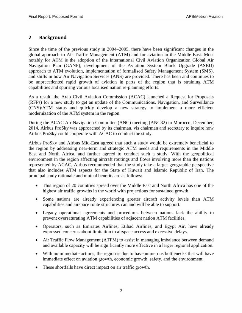
2 Background
Since the time of the previous study in 2004–2005, there have been significant changes in the
global approach to Air Traffic Management (ATM) and for aviation in the Middle East. Most
notably for ATM is the adoption of the International Civil Aviation Organization Global Air
Navigation Plan (GANP), development of the Aviation System Block Upgrade (ASBU)
approach to ATM evolution, implementation of formalised Safety Management System (SMS),
and shifts in how Air Navigation Services (ANS) are provided. There has been and continues to
be unprecedented rapid growth of aviation in parts of the region that is straining ATM
capabilities and spurring various localised nation re-planning efforts.
As a result, the Arab Civil Aviation Commission (ACAC) launched a Request for Proposals
(RFPs) for a new study to get an update of the Communications, Navigation, and Surveillance
(CNS)/ATM status and quickly develop a new strategy to implement a more efficient
modernization of the ATM system in the region.
During the ACAC Air Navigation Committee (ANC) meeting (ANC32) in Morocco, December,
2014, Airbus ProSky was approached by its chairman, vis chairman and secretary to inquire how
Airbus ProSky could cooperate with ACAC to conduct the study.
Airbus ProSky and Airbus Mid-East agreed that such a study would be extremely beneficial to
the region by addressing near-term and strategic ATM needs and requirements in the Middle
East and North Africa, and further agreed to conduct such a study. With the geopolitical
environment in the region affecting aircraft routings and flows involving more than the nations
represented by ACAC, Airbus recommended that the study take a larger geographic perspective
that also includes ATM aspects for the State of Kuwait and Islamic Republic of Iran. The
principal study rationale and mutual benefits are as follows:
This region of 20 countries spread over the Middle East and North Africa has one of the
highest air traffic growths in the world with projections for sustained growth.
Some nations are already experiencing greater aircraft activity levels than ATM
capabilities and airspace route structures can and will be able to support.
Legacy operational agreements and procedures between nations lack the ability to
prevent oversaturating ATM capabilities of adjacent nation ATM facilities.
Operators, such as Emirates Airlines, Etihad Airlines, and Egypt Air, have already
expressed concerns about limitation to airspace access and excessive delays.
Air Traffic Flow Management (ATFM) to assist in managing imbalance between demand
and available capacity will be significantly more effective in a larger regional application.
With no immediate actions, the region is due to have numerous bottlenecks that will have
immediate effect on aviation growth, economic growth, safety, and the environment.
These shortfalls have direct impact on air traffic growth.

Final Report: Proposed Format APS/Metron Aviation
3
Since the Airbus initial recommendation on the study scope, the State of Kuwait has joined the
ACAC organization making it an eligible participant in the study, while a decision was made to
address the Islamic Republic of Iran separately.
2.1 ACAC Membership
The ACAC Member States are listed in Table 1.
Table 1: ACAC Member States
State State
People’sDemocraticRepublic of Algeria
Kingdom of Morocco
Kingdom of Bahrain
Sultanate of Oman
Arab Republic of Egypt
State of Palestine
Republic of Iraq
State of Qatar
Hashemite Kingdom of Jordan
Kingdom of Saudi Arabia
State of Kuwait
Republic of Sudan
Republic of Lebanon
Syrian Arab Republic
Great Peoples Socialist Libyan Arab Jamahiriya
Republic of Tunisia
Islamic Republic of Mauritania
United Arab Emirates
Republic of Yemen
Final Report: Proposed Format APS/Metron Aviation
4
2.2 ACAC Regional Description
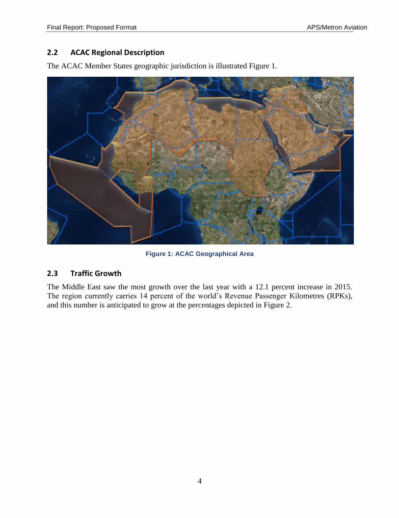
The ACAC Member States geographic jurisdiction is illustrated Figure 1.
Figure 1: ACAC Geographical Area
2.3 Traffic Growth
The Middle East saw the most growth over the last year with a 12.1 percent increase in 2015.
The region currently carries 14 percent of the world’s Revenue Passenger Kilometres (RPKs),
and this number is anticipated to grow at the percentages depicted in Figure 2.

Final Report: Proposed Format APS/Metron Aviation
5
Figure 2: Middle East 2015 Traffic Increases
Airlines in the Middle East are forecasted to require 3,180 new airplanes over the next 20 years,
with rapid fleet expansion in the region driving an estimated 70 percent of that demand, see
Appendix A for the regional fleet mix. [Boeing]
Traffic growth in the Middle East continues to grow at a rate and is expected to grow 6.2 percent
annually during the next 20 years. Approximately 80 percent of the world's population lives
within an eight-hour flight of the Arabian Gulf. This geographic position, coupled with diverse
business strategies and investment in infrastructure is allowing carriers in the Middle East to
aggregate traffic at their hubs and offer one-stop service between many city pairs that would not
otherwise enjoy such direct itineraries. [Boeing]
The Middle East growth can be in part attributed to the continued development of airport hub
operations as focal points between East and West, and supplemented by the rise of trade links
between Africa, the Middle East and Asia. In 2014 economic growth in the United States (US)
also boosted Middle East – North America traffic.
According to ICAO, African air traffic grew at a rate of 0.6 percent in 2015, but a recent IATA
report finds that African carriers may have seen a loss of an estimated $300 million this year.
Breakeven load factors are relatively low, as yields are a little higher than average and costs are
lower. However, few airlines in the region are able to achieve adequate load factors, which
average the lowest globally at 56 percent in 2015 and 2016. [IATA Year End Report]
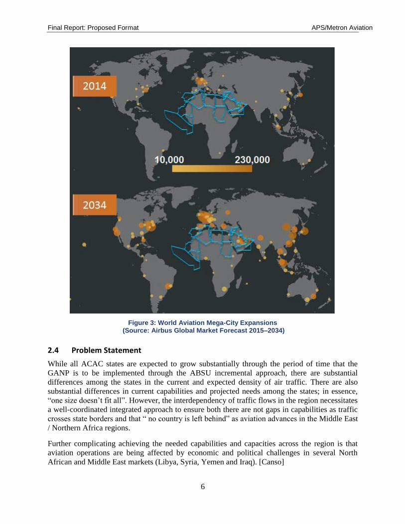
Next two decades annual growth estimated trend: regional +5.9% vs. global +4%, increase in
passengers from 125M to 377M. [AFI/MID WS ASBU], see Figure 3.
Final Report: Proposed Format APS/Metron Aviation
6
Figure 3: World Aviation Mega-City Expansions (Source: Airbus Global Market Forecast 2015–2034)
2.4 Problem Statement
While all ACAC states are expected to grow substantially through the period of time that the
GANP is to be implemented through the ABSU incremental approach, there are substantial
differences among the states in the current and expected density of air traffic. There are also
substantial differences in current capabilities and projected needs among the states; in essence,
“one size doesn’t fit all”. However, the interdependency of traffic flows in the region necessitates
a well-coordinated integrated approach to ensure both there are not gaps in capabilities as traffic
crosses state borders and that “ no country is left behind” as aviation advances in the Middle East
/ Northern Africa regions.
Further complicating achieving the needed capabilities and capacities across the region is that
aviation operations are being affected by economic and political challenges in several North
African and Middle East markets (Libya, Syria, Yemen and Iraq). [Canso]

Final Report: Proposed Format APS/Metron Aviation
7
2.5 Previous Related Work
Both the previous CNS-ATM Study by Sofreavia and the work done by Airbus ProSky, in
support of the United Arab Emirates (UAE), provided a good foundation for this ACAC
CNS/ATM Study Update & Strategic Planning (2015–2030) effort.
2.5.1 ACAC CNS-ATM Study
The ACAC CNS-ATM Study was conducted by Sofreavia in the 2004–2006 timeframe as part of
ACAC’s effort to address the future of ATM and CNS in the region through 2020. Some of the
most notable aspects from that study of particular relevance to the current study were:
Identification of current and potential traffic bottlenecks, mostly in the Middle East.
Creation of three (3) homogenous areas reflecting different fundamental traffic flows and
operational air traffic density
Development of a high-level CNS/ATM roadmap to serve as guidance for state planning
and deployment priorities, with a recommendation that it be regularly updated
Recommendation to develop a regional Air Traffic Flow Management entity
2.5.2 UAE Airspace and ATM Study
The UAE General Civil Aviation Authority (GCAA) awarded Airbus ProSky a contract to
conduct the UAE Airspace and Air Traffic Management (ATM) Study. The UAE Airspace Study
formed an important step in GCAA’s efforts to foster the UAE’s aviation sector future to 2030.
Those efforts reflect the vital role that aviation plays in the UAE’s economy and society. The
successful growth of the aviation sector is founded in the GCAA’s stated vision to promote “A
leading, safe, secure and sustainable civil aviation system.”
Optimizing the use of available airspace and planning for the projected expansive growth in
aviation pose substantial challenges. Recent growth is very much tied to the success of the
UAE’s national airlines and establishing UAE airports as worldwide hubs. The national airlines
have large aircraft order books and their aircraft are equipped with advanced technologies to take
advantage of emerging capabilities. Added to the challenges are the increasing traffic levels that
transit UAE airspace due to its location at a geographic crossroads in region.
There were three distinct internal phases of the Study:
Phase 1 – Assessing Current and Future System Needs and Capabilities
Phase 2 – Gap Analysis
Phase 3 – Developing Findings and Recommendations Figure 4 provides an overview of how the
guiding principles were applied to the Study effort, including the major coordination points with
the GCAA and stakeholders.

Final Report: Proposed Format APS/Metron Aviation
8
Figure 4: Overview of Airspace Study Coordination and Interfaces
Of particular relevance to the current study effort was the extensive coordination with aviation
stakeholders both within the UAE and external FIRs and States, including from a number of the
ACAC states part of this stud concerning current capabilities and the needed and expected
aviation environment through 2030. The comprehensive stakeholder outreach as part of the study
included:
Air Navigation Service Providers
Airline and Aircraft Operators
Airports
Government
External
One of the key outputs of the study was a succinct characterization of the strategic vision of the
2030 UAE ATM system and aviation environment that will resonate with airspace stakeholders
as achievable targets they can focus their planning on. The resulting End Stage Statement, see
Figure 5, has relevance to the current study in that many of the ACAC objectives are similar for
their member states.
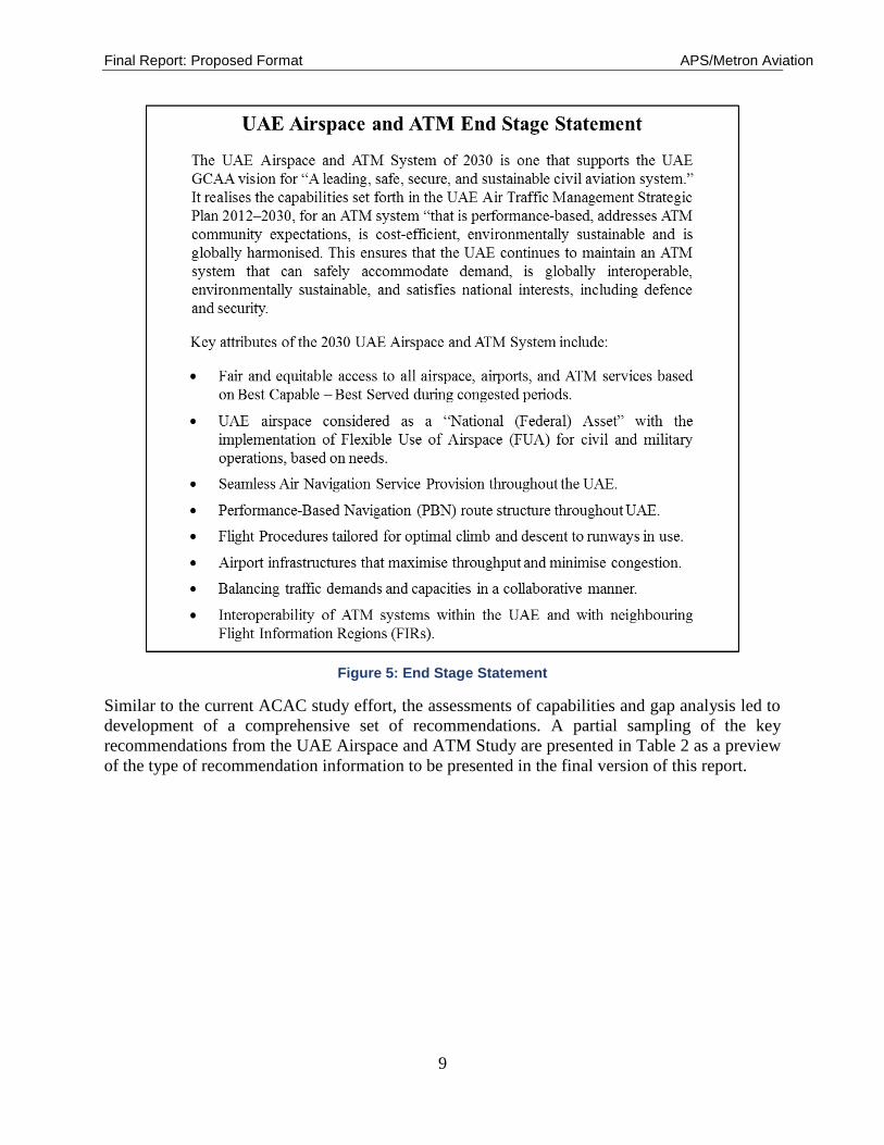
Final Report: Proposed Format APS/Metron Aviation
9
Figure 5: End Stage Statement
Similar to the current ACAC study effort, the assessments of capabilities and gap analysis led to
development of a comprehensive set of recommendations. A partial sampling of the key
recommendations from the UAE Airspace and ATM Study are presented in Table 2 as a preview
of the type of recommendation information to be presented in the final version of this report.
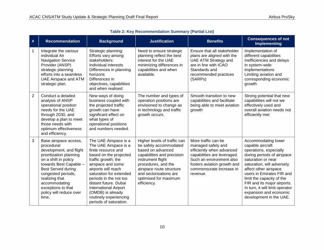
ACAC CNS/ATM Study Update & Strategic Planning Draft Final Report Airbus ProSky
10
Table 2: Key Recommendation Summary (Partial List)
# Recommendation Background Justification Benefits Consequences of not
Implementing
1 Integrate the various individual Air Navigation Service Provider (ANSP) strategic planning efforts into a seamless UAE Airspace and ATM strategic plan.
Strategic planning: Efforts vary among stakeholders: Individual interests Differences in planning horizons Differences in objectives, capabilities and when realised
Need to ensure strategic planning reflect the best interest for the UAE minimizing differences in capabilities and when available.
Ensure that all stakeholder plans are aligned with the UAE ATM Strategy and are in line with ICAO Standards and recommended practices (SARPs)
Implementation of different capabilities Inefficiencies and delays in system-wide implementations Limiting aviation and corresponding economic growth
2 Conduct a detailed analysis of ANSP operational position needs for the UAE through 2030, and develop a plan to meet those needs with optimum effectiveness and efficiency.
New ways of doing business coupled with the projected traffic growth can have significant effect on what types of operational positions and numbers needed.
The number and types of operation positions are envisioned to change as in technology and traffic growth occurs.
Smooth transition to new capabilities and facilitate being able to meet aviation growth
Strong potential that new capabilities will not we effectively used and overall aviation needs not efficiently met
3 Base airspace access, procedural development, and flight prioritization planning on a shift in policy towards Best Capable – Best Served during congested periods, realizing that accommodating exceptions to that policy will reduce over time.
The UAE Airspace is a The UAE Airspace is a finite resource and based on the projected traffic growth; the airspace and some airports will reach saturation for extended periods in the not too distant future. Dubai International Airport (OMDB) is already routinely experiencing periods of saturation.
Higher levels of traffic can be safely accommodated based on advanced capabilities and precision instrument flight procedures, and the airspace route structure and sectorisations are optimised for maximum efficiency.
More traffic can be managed safely and efficiently when advanced capabilities are leveraged. Such an environment also fosters aviation growth and commensurate increase in revenue.
Accommodating lower capable aircraft operations, especially during periods of airspace saturation or near saturation, will adversely affect other airspace users in Emirates FIR and limit the capacity of the FIR and its major airports. In turn, it will limit operator expansion and economic development in the UAE.
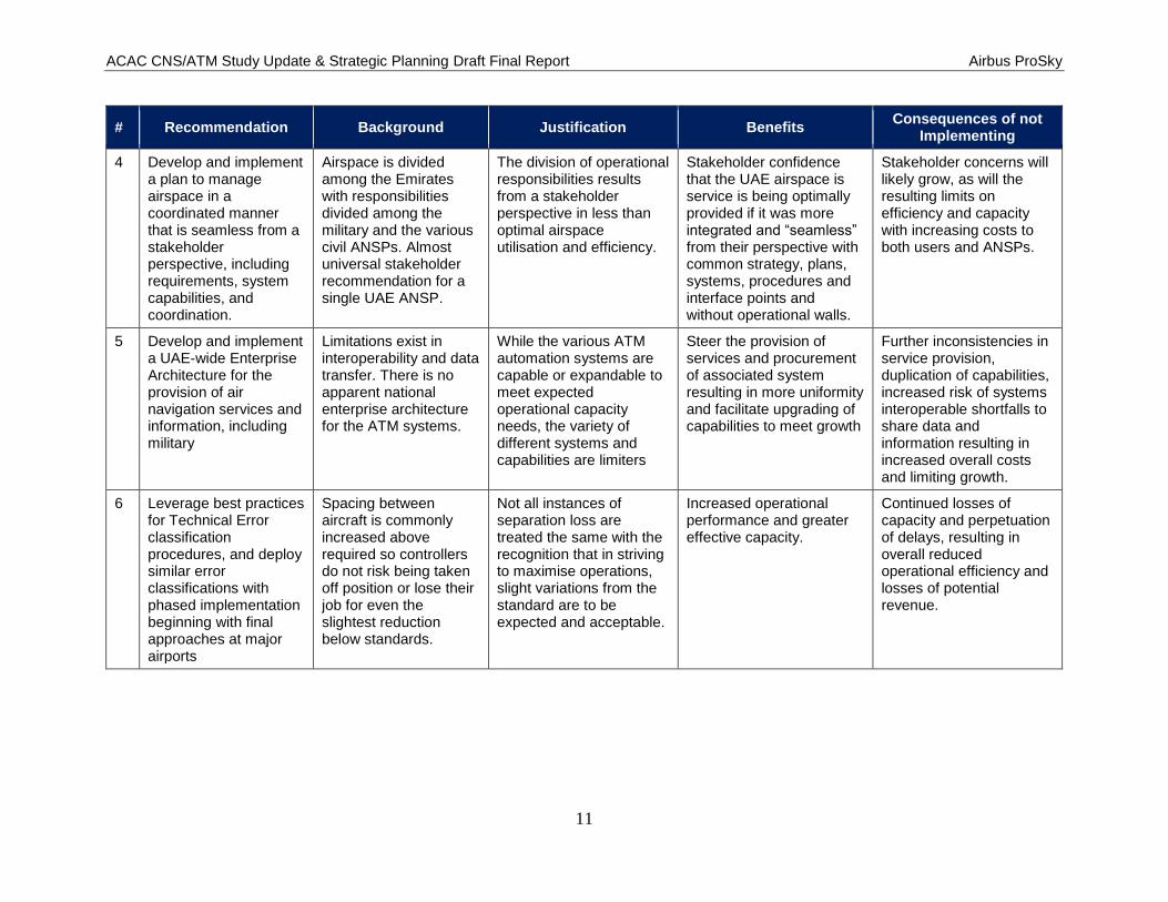
ACAC CNS/ATM Study Update & Strategic Planning Draft Final Report Airbus ProSky
11
# Recommendation Background Justification Benefits Consequences of not
Implementing
4 Develop and implement a plan to manage airspace in a coordinated manner that is seamless from a stakeholder perspective, including requirements, system capabilities, and coordination.
Airspace is divided among the Emirates with responsibilities divided among the military and the various civil ANSPs. Almost universal stakeholder recommendation for a single UAE ANSP.
The division of operational responsibilities results from a stakeholder perspective in less than optimal airspace utilisation and efficiency.
Stakeholder confidence that the UAE airspace is service is being optimally provided if it was more integratedand“seamless”from their perspective with common strategy, plans, systems, procedures and interface points and without operational walls.
Stakeholder concerns will likely grow, as will the resulting limits on efficiency and capacity with increasing costs to both users and ANSPs.
5 Develop and implement a UAE-wide Enterprise Architecture for the provision of air navigation services and information, including military
Limitations exist in interoperability and data transfer. There is no apparent national enterprise architecture for the ATM systems.
While the various ATM automation systems are capable or expandable to meet expected operational capacity needs, the variety of different systems and capabilities are limiters
Steer the provision of services and procurement of associated system resulting in more uniformity and facilitate upgrading of capabilities to meet growth
Further inconsistencies in service provision, duplication of capabilities, increased risk of systems interoperable shortfalls to share data and information resulting in increased overall costs and limiting growth.
6 Leverage best practices for Technical Error classification procedures, and deploy similar error classifications with phased implementation beginning with final approaches at major airports
Spacing between aircraft is commonly increased above required so controllers do not risk being taken off position or lose their job for even the slightest reduction below standards.
Not all instances of separation loss are treated the same with the recognition that in striving to maximise operations, slight variations from the standard are to be expected and acceptable.
Increased operational performance and greater effective capacity.
Continued losses of capacity and perpetuation of delays, resulting in overall reduced operational efficiency and losses of potential revenue.
ACAC CNS/ATM Study Update & Strategic Planning Draft Final Report Airbus ProSky
12
3 Project Objectives, and Scope of Work
This section contains the contractual information derived from the signed agreement between the
affected parties.
This section of the Statement of Work (SOW) identifies what the Airbus ProSky Team
understands to be the overall objectives to the ACAC study effort along with the Team’s
approach and methodology to meeting those objectives.
The nominal structure includes the following sub-sections:
3.1 Project Objectives
The ATM Study intent is to develop both near-term requirements and longer term strategic needs
to formulate a master plan for regional air navigation service provision through 2030. Included
will be a recommended systematic process to prioritise and balance investments aiming to
optimise ATM for the Arab Middle East and Northern Africa area.
The region’s economic growth and prominence in the global environment is strongly linked to its
aviation sector. A significant portion of the Gross Domestic Product (GDP) of various nations is
either directly resultant from the aviation sector employment and services or indirectly
contributed to by enabling tourism, finance, and other service industries through its robust and
progressive aviation sector. Many of the national airlines are preparing for expansive growth
over the next decade and beyond, projected in the range of 5% or more annually. The national
airlines are upgrading their fleets in numbers of aircraft, size, and capabilities. Many airlines
already have some of the newest and most modern fleets in the industry and their order books
clearly indicate that they will become world leaders. Many airlines are uniquely positioned to
take advantage of the advancing ATM capabilities emerging in many parts of the world to
transform aviation to meet capacity, efficiency, and environmental needs of the future.
The Air Navigation Service Providers (ANSPs) and civil aviation authorities have developed
strategic plans to address the growing needs. There are, however, substantial challenges in being
able to effectively accommodate the anticipated aviation growth and expectations of its
stakeholders. Some aspects of the current regional ATM system are already experiencing
extended periods of airborne holding or ground departure delays. The need to increase airspace
capacity, provide increased access to airports, improve efficiency for both aviation system
customers and ANSPs and reduce environmental impacts while continuing to maintain, foster,
and promote safety is paramount. Specific objectives to be highlighted in the Regional Concepts
for the year 2030 and transition from today’s system include:
Improve airspace safety and efficiency
Improve interoperability between ANSPs to foster seamless services across borders
Increase airspace capacity to meet future demand requirements
Increase access to airports

ACAC CNS/ATM Study Update & Strategic Planning Draft Final Report Airbus ProSky
13
Reduce environmental impact of increasing traffic by providing improved ATM
operations
The ATM Study successfully provides a pivotal element towards meeting the strategic goals and
objectives of the regional aviation sector and supporting a vibrant regional economy.
3.2 Scope of Work
The initial scope of the study is defined as follows:
Time Scale: Traffic forecasting (traffic growth scenario for the coming 15 years) and
issues analysis is required for a 15-year time Horizon (2015 – 2030). The planning period
will be initially segmented between a 5 - year horizon through 2020 for identification of
near-term Global Best Practices recommendations and strategic reference of the regional
environment and needs in the 2025 and 2030 timeframes.
Key performance areas: The primary focuses of the planning process will be on safety,
capacity, airspace access, flight efficiency, routing flexibility, predictability, equity,
collaboration, interoperability, ensuring security and environmental impact and best value
solutions.
Geographically: The study will cover ACAC area (19 Arab States as illustrated in Table 1
(see section 2.1), but primarily only the regional aspect is to be considered. The national
aspect is included only as it pertains to cross border and regional ATM plans and
requirements.
The ATM Study is to be based on the GANP, ABSUs and relevant documents, and will ensure
the coverage of all ACAC Member States and consider the interaction with neighbouring areas,
including Iran.
3.3 Deliverables
As required, the Airbus ProSky Team is providing the following as deliverables for the ACAC
ATM Study. Identified are both formal document deliveries and anticipated project meetings
involving the ACAC and Airbus ProSky Study team, the planned format and due dates, in terms
of weeks after award of the study.
Table 3 provides a summary concerning the proposed deliverables.
Table 3: Deliverables Schedule
Deliverables Deliverable Type Due Date:
Months after study award
Notes/Explanations
Kick-off Meeting 1 Project planning discussion and draft initial stakeholder questionnaire
Data Collection / Stakeholder Consultations
Questionnaires/Responses 6 Questionnaire responses, Bi-lateral follow-up discussion summaries and workshop updates

ACAC CNS/ATM Study Update & Strategic Planning Draft Final Report Airbus ProSky
14
Deliverables Deliverable Type Due Date:
Months after study award
Notes/Explanations
ATM Assessment Briefing / WebEx 8 Presentation for beginning Study Gap Analysis
Gap Analysis / Findings
Briefing / Presentation 10 Workshop with all Nations invited
Final ATM Study Report
Report / Presentation 12
3.4 Timelines
Figure 6 is a representation of the project activities and timeline described previously as
modified from this proposal and captured in the initial SOW.
Figure 6: Proposed Project Timeline
3.5 Modifications to Timelines
During the performance of the study, some challenges were encountered in obtaining data from
some of the ACAC member states and for some other states within planned timeframes. Figure 7
reflects the schedule variance that had resulted by December 2015 from the initial data
availability shortfalls.

ACAC CNS/ATM Study Update & Strategic Planning Draft Final Report Airbus ProSky
15
Figure 7: Project Timeline Variance as of December 2015
The difficulties in obtaining data continued into the spring of 2016 and were significantly
affecting completion of the study. As a result, there was agreement to proceed ahead based on
what data was available as of 18 March 2016, with accommodation of information after that date
to be done as practical.
By the April 2016 Gap Analysis presentation, while quite a bit of the requested data from
member States had begun to be provided, there were some significant shortfalls impacting the
ability of the study team to develop comprehensive finds and recommendations to meet the
original milestone schedule. Figure 8 reflects the milestone schedule as presented during the Gap
Analysis presentation.
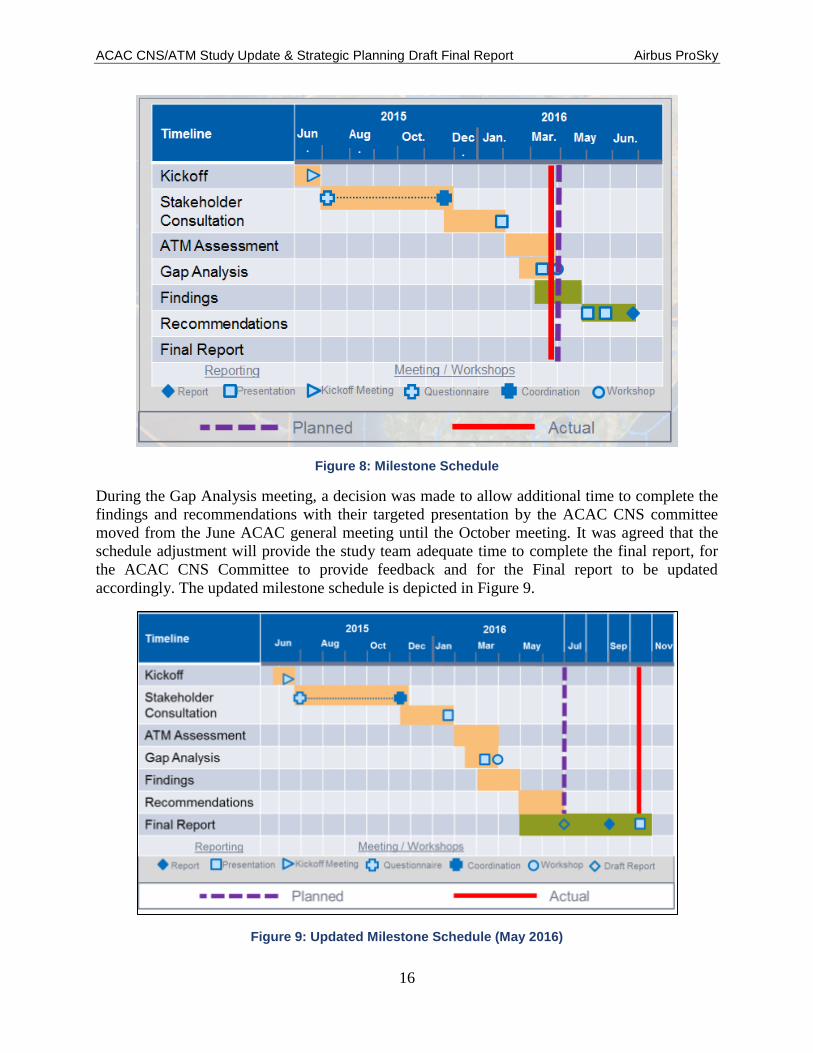
ACAC CNS/ATM Study Update & Strategic Planning Draft Final Report Airbus ProSky
16
Figure 8: Milestone Schedule
During the Gap Analysis meeting, a decision was made to allow additional time to complete the
findings and recommendations with their targeted presentation by the ACAC CNS committee
moved from the June ACAC general meeting until the October meeting. It was agreed that the
schedule adjustment will provide the study team adequate time to complete the final report, for
the ACAC CNS Committee to provide feedback and for the Final report to be updated
accordingly. The updated milestone schedule is depicted in Figure 9.
Figure 9: Updated Milestone Schedule (May 2016)

ACAC CNS/ATM Study Update & Strategic Planning Draft Final Report Airbus ProSky
17
3.6 Risk Management
Airbus ProSky has identified the risks inherent in this study and developed the associated
mitigation procedures.
According to “NO COUNTRY LEFT BEHIND” approach, the associated mitigation to the risk
of insufficient data collected from some concerned States, due to the political situation in the
region, should be addressed as appropriate.
Airbus ProSky recognised that risks could lead to delay or to a limitation of the scope of the
study or to difficulties in the development or acceptance of its conclusions.
3.7 Identified Risks
The key risk at the start of the study was ensuring timely and comprehensive response by ACAC
member to questionnaires and follow-on discussions.
3.8 Term of Reference, Roles & Responsibilities
In accordance with the Terms of Reference, the following ACAC responsibilities were provided
to the Study Team:
3.8.1 ACAC Roles & Responsibilities are:
ACAC nominate a Project Manager for the CNS ATM study from the secretary.
ACAC will designate study focal points from each Member State.
ACAC will contribute, as much as possible according to the political situation in the
region, with the necessary inputs for the data collection phase.
ACAC will provide feedback for the refinement of the study assumptions and State
replies.
ACAC will provide feedback for the refinement of the Airbus ProSky analysis and
recommendations and actions plan.
ACAC will provide all necessary inputs to promote the study results at the regional and
international level, through the ACAC magazine, website, presentations during its
technical committee, council and assembly, and as appropriate during the regional and
international meetings and conferences.
3.8.2 ACAC Project Manager of the CNS/ATM Roles & Responsibilities
The ACAC project manager of the CNS/ATM study is responsible for the following:
Ensure the coordination of the programme schedules, management of the major
milestones relating to the CNS/ATM study.
Ensure the coordination with the Focal Points designated nationally for the CNS/ATM
study, to ensure the timely data collection according to the SOW and related timeline.

ACAC CNS/ATM Study Update & Strategic Planning Draft Final Report Airbus ProSky
18
Ensure the close coordination with Airbus ProSky Project Manager appointed for the
CNS/ATM study and also with the rest of Project Team.
Provide the ACAC feedbacks for the refinement of the study assumptions and State
replies, further coordination with focal points.
Provide the ACAC feedbacks for the refinement of the Airbus ProSky analysis and
recommendations and actions plan, further coordination with ANC (Air Navigation
Committee) chairman.
Facilitate the development of the study and ensure the fulfilment of SOW.
Facilitate the necessary inputs to promote the study result at the regional and international
level, through the ACAC magazine, website, presentations during ANC, council and
assembly meeting, and as appropriate during the regional and international meeting and
conference.
Present CNS/ATM study progress reports during the ACAC air navigation committee
meetings.

ACAC CNS/ATM Study Update & Strategic Planning Draft Final Report Airbus ProSky
19
4 Methodology/Approach
This section describes the methodology and approaches used throughout the study consistent
with the SOW, and include (1) work teams, (2) data identification and collection, (3)
comparative analysis, and (4) baseline ASBU Block descriptions.
The Airbus ProSky Team used an effective approach to the ATM Study. The effort necessitated
using a highly qualified and diverse team of multi-discipline industry experts in not only
studying aviation systems, but with real-world experience managing them and implementing
major new capabilities and system enhancements. The Airbus ProSky Team will draw upon the
expertise of its companies and Airbus for world leading aviation expertise to form the core of the
ATM Study Team.
Further, with the wealth of knowledge resident within these organisations, Airbus ProSky has
access to a wealth of other resources within Airbus, as well as a number of whom have
experiences and relationships within the Middle East as they have with airspace regulators,
ANSPs, stakeholders, governing bodies and international organisations throughout the region,
and globally. These credible relationships will be valuable in ensuring the study is collaborative
and inclusive regional aviation stakeholders and ANSPs, in addition to gaining the necessary
buy-in to make the study successful.
While the RFP outlined a study approach predicated on providing updates to the previous study,
the breadth of changes in the aviation environment and regional environment would render such
an approach to have only minimal benefit. As a result, Airbus ProSky will approach will be
focused on both 2030 needs and the nearer term requirements that could be realised by 2020 and
2025. The overall approach to the ATM Study is shown in Figure 10.
Figure 10: ATM Study Approach

ACAC CNS/ATM Study Update & Strategic Planning Draft Final Report Airbus ProSky
20
4.1 Project Work Team
The work project team is depicted in Figure 11, and consists of recognised experts in their fields
of operations spanning many years of operational, administrative, and managerial air traffic and
analytical experience.
Figure 11: Work Project Team
4.2 Airbus ProSky Program and Technical Managers
Airbus ProSky provided both a Program Manager and Technical Manager. The Program
Manager is the main point of contact (POC) for the ACAC and is responsible for high-level
programme schedules, management to the major milestones, and contract management. Contract
management for clarifications, modifications, and amendments is performed in close
coordination with the Airbus ProSky contracts team and the ACAC contracts team. The Program
Manager provides periodic reporting on status, next steps, milestone tracking, and outstanding
risks.
The Program Manager was supported by a Technical Manager regarding detailed task-level
implementation plans and resolution of technical issues affecting major milestones associated
with the implementation and trial period. The Technical Manager worked closely to coordinate
technical efforts across the project. The Technical Manager was the technical POC for the
ACAC and is responsible for the detailed implementation plan, professional services, resource

ACAC CNS/ATM Study Update & Strategic Planning Draft Final Report Airbus ProSky
21
assignments, technical project management, and resolution of technical issues. The Technical
Manager closely coordinates with the Program Manager, provides frequent status updates, and
supports relevant activities and the resolution of issues.
4.3 ACAC Project Team and Program Managers
ACAC provided a Project Manager and State focal points. The Project Manager was the main
point of contact for the ACAC and is responsible for coordination of the programme schedules,
management to the major milestones, and contract management. The Program Manager provided
periodic reporting on status, next steps, milestone tracking, and outstanding risks to the ACAC
air navigation Committee, which has been tasked by the ACAC executive council to follow up
the CNS/ATM study.
The State focal points were responsible to provide technical input and data as requested and in
the required timeframe.
4.4 Key Study Elements
Key elements of the ATM Study included:
Establish reusable databases with data collected during the study from ANSPs and
involved / concerned stakeholders.
Provide an up-to-date picture of CNS/ATM developments and needs in the ACAC region
through 2030.
Link International Civil Aviation Organization (ICAO) GANP and relevant ASBU with
regional planning and individual State activities, to identify areas where ACAC could
look to coordinate harmonised ATM.
Identify gaps in CNS-ATM in the region, and set pragmatic objectives to build capability
to solve the issues identified.
Formulate solid recommendations to enable ACAC to enhance its coordination and
planning for the region, giving objective justification for regional initiatives by ACAC.
Support the implementation of the capacity and efficiency priorities such as PBN,
Continuous Descent Operations/Continuous Climb Operations (CDO/CCO), ATFM and
Aeronautical Information Management (AIM) as well as the regional air navigation
priorities defined in the Middle East region air navigation strategy
4.5 Study Phases
The Airbus ProSky Team conducted the study in three distinct phases. Phase 1 of the study was
an assessment of the current regional airspace, ATM procedures, and CNS infrastructure.
Phase 2 provides an analysis of gaps between the current system and the uncertainty of projected
system demands, how to best deal with this uncertainty, and planned capabilities at defined
future timeframes. Phase 3 of the study provided the formulation of recommendations to address
the gaps identified in Phase 2.
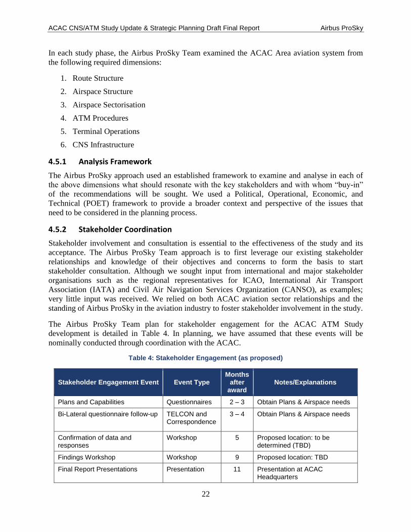
ACAC CNS/ATM Study Update & Strategic Planning Draft Final Report Airbus ProSky
22
In each study phase, the Airbus ProSky Team examined the ACAC Area aviation system from
the following required dimensions:
1. Route Structure
2. Airspace Structure
3. Airspace Sectorisation
4. ATM Procedures
5. Terminal Operations
6. CNS Infrastructure
4.5.1 Analysis Framework
The Airbus ProSky approach used an established framework to examine and analyse in each of
the above dimensions what should resonate with the key stakeholders and with whom “buy-in”
of the recommendations will be sought. We used a Political, Operational, Economic, and
Technical (POET) framework to provide a broader context and perspective of the issues that
need to be considered in the planning process.
4.5.2 Stakeholder Coordination
Stakeholder involvement and consultation is essential to the effectiveness of the study and its
acceptance. The Airbus ProSky Team approach is to first leverage our existing stakeholder
relationships and knowledge of their objectives and concerns to form the basis to start
stakeholder consultation. Although we sought input from international and major stakeholder
organisations such as the regional representatives for ICAO, International Air Transport
Association (IATA) and Civil Air Navigation Services Organization (CANSO), as examples;
very little input was received. We relied on both ACAC aviation sector relationships and the
standing of Airbus ProSky in the aviation industry to foster stakeholder involvement in the study.
The Airbus ProSky Team plan for stakeholder engagement for the ACAC ATM Study
development is detailed in Table 4. In planning, we have assumed that these events will be
nominally conducted through coordination with the ACAC.
Table 4: Stakeholder Engagement (as proposed)
Stakeholder Engagement Event Event Type Months
after award
Notes/Explanations
Plans and Capabilities Questionnaires 2 – 3 Obtain Plans & Airspace needs
Bi-Lateral questionnaire follow-up TELCON and Correspondence
3 – 4 Obtain Plans & Airspace needs
Confirmation of data and responses
Workshop 5 Proposed location: to be determined (TBD)
Findings Workshop Workshop 9 Proposed location: TBD
Final Report Presentations Presentation 11 Presentation at ACAC Headquarters

ACAC CNS/ATM Study Update & Strategic Planning Draft Final Report Airbus ProSky
23
Through ACAC facilitation, we collated the information from the earlier study effort. The initial
outreach was conducted through questionnaires to the various national civil aviation authorities,
ANSPs and stakeholder organisation(s).
We worked closely with ACAC in the preparation of stakeholder presentations and
questionnaires. We viewed it as vital that there is agreement with and approval of all materials
presented to stakeholders.
4.5.3 ACAC Coordination
Airbus ProSky believes that a close-working relationship with the ACAC and routine
interactions are essential to a successful study effort. Fundamentally, the Airbus ProSky Team
approach was to discuss upcoming activities with the ACAC and get their concurrence before
moving to the next phase of the study. Our approach was to provide a “quick look” briefing at
the completion of all intermediate phases. For the final report, we are coordinating findings and
recommendations with the ACAC prior to the associated stakeholder sessions.
At the kick off, Airbus ProSky discussed the proposed study approach with ACAC and work
collaboratively to ensure there is common understanding and agreement before proceeding.
Because of the number of nations within the study scope, Airbus ProSky needs ACAC designate
a Point of Contact (POC) in their organisation to provide guidance and facilitate coordination.
4.6 Communications Plan
Table 5 represents the communications plan for the ACAC Study.
Table 5: Communications Plan
Comm Type Objective of
Communication Medium Frequency Audience Owner
Kick-off Meeting
Review project objectives and management approach
- Face to Face Once - Project Sponsor
Project Manager
- Project Team
- Stakeholders
Project Team Meetings
Review status of the project with the team
- Face to Face Weekly - Project Team Project Manager
- Conference Call
Technical Team Meetings
Discuss and develop technical solutions
- Face to Face As Needed - Project Technical Staff
Technical Lead
Monthly Project Status
Report on the status of the project
One Interim face-to-face
meeting
Monthly TELCON
- Project Management Office (PMO)
Project Manager
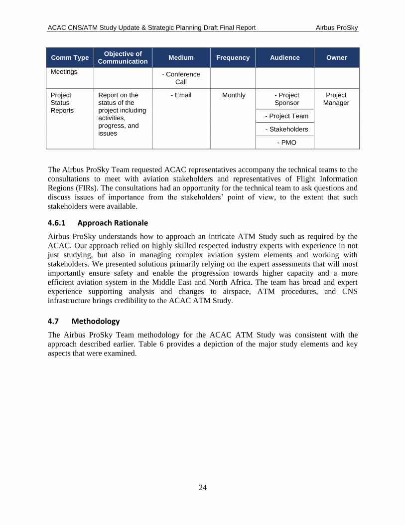
ACAC CNS/ATM Study Update & Strategic Planning Draft Final Report Airbus ProSky
24
Comm Type Objective of
Communication Medium Frequency Audience Owner
Meetings - Conference Call
Project Status Reports
Report on the status of the project including activities, progress, and issues
- Email Monthly - Project Sponsor
Project Manager
- Project Team
- Stakeholders
- PMO
The Airbus ProSky Team requested ACAC representatives accompany the technical teams to the
consultations to meet with aviation stakeholders and representatives of Flight Information
Regions (FIRs). The consultations had an opportunity for the technical team to ask questions and
discuss issues of importance from the stakeholders’ point of view, to the extent that such
stakeholders were available.
4.6.1 Approach Rationale
Airbus ProSky understands how to approach an intricate ATM Study such as required by the
ACAC. Our approach relied on highly skilled respected industry experts with experience in not
just studying, but also in managing complex aviation system elements and working with
stakeholders. We presented solutions primarily relying on the expert assessments that will most
importantly ensure safety and enable the progression towards higher capacity and a more
efficient aviation system in the Middle East and North Africa. The team has broad and expert
experience supporting analysis and changes to airspace, ATM procedures, and CNS
infrastructure brings credibility to the ACAC ATM Study.
4.7 Methodology
The Airbus ProSky Team methodology for the ACAC ATM Study was consistent with the
approach described earlier. Table 6 provides a depiction of the major study elements and key
aspects that were examined.

ACAC CNS/ATM Study Update & Strategic Planning Draft Final Report Airbus ProSky
25
Table 6: Study Elements and Key Aspects
4.7.1 Study Phases
In the following sections, we provide further detail on our approach and how we conducted study
activities.
4.7.1.1 Kick Off
Airbus ProSky Team approached the study kick off in a manner that reflects the importance of
starting the study prepared. This attention to detail and timeliness assures the ACAC that we are
ready to begin the study and focused on ensuring a successful outcome for the ACAC, the
Middle East and North Africa
We prepared for the kick off, by leveraging the Airbus ProSky’s extensive knowledge of the
Middle East region understanding of stakeholders concerns, plans and interests and by reviewing
the various applicable reports and plans. A number of the Airbus ProSky representatives who are
participating in the ACAC ATM Study have recent experiences working with UAE General
Civil Aviation Authority (GCAA) Airspace stakeholders in implementing capabilities in the
UAE and participating with on-going current efforts for improving aspects of the UAE aviation
system. The familiarity of the Airbus ProSky Team with the Middle East airspace and ATM
system effectively negated the traditional start up needs. The experts on the Airbus ProSky Team
have much familiarity with such study efforts and the needed to get started quickly and
effectively.
At the kick off, we presented the ACAC with a current project plan reflective of the actual start
date and a draft presentation and questions for the first round of stakeholder sessions. We
ACAC CNS/ATM Study Update & Strategic Planning Draft Final Report Airbus ProSky
26
prepared to work with the ACAC onsite to finalise the draft presentation and questions and
prepare for scheduling discussions and coordinating stakeholder sessions.
As addressed earlier in this proposal, the Airbus ProSky Team entered into a close-working
relationship with the ACAC as essential to the study success. We discussed the specifics of that
working relationship and key interface elements. We recommend bi-weekly communications
between the Study Team Project Manager and the ACAC, with in-person meets on a nominal
quarterly basis.
Terms of reference, roles and responsibilities of the Project Team and ACAC were discussed and
fundamentally agreed to.
In addition, according to “NO COUNTRY LEFT BEHIND” approach,, the associated mitigation
to the risk of insufficient data collected from some concerned States, due to the political situation
in the region was recognised as a risk that could lead to delay or to a limitation of the scope of
the study or result in difficulties in the development or acceptance of the study conclusions.
4.7.1.2 Stakeholder Data Gathering and Questionnaires
The Airbus ProSky Team worked with ACAC to obtain stakeholder input primarily through use
of questionnaires. As addressed earlier, we coordinated the content of the questionnaires through
ACAC as well as relied on ACAC to provide the interface with the ACAC members for
responding to the questionnaires and facilitating follow-up discussions. Near the end of the data
gathering effort, the Airbus ProSky Team conducted a workshop with the ACAC members to
review and confirm the overall input received. The stakeholder responses and updates resulting
from the follow-on discussions were provided to ACAC to support further updates in the future
of the CNS/ATM study.
To affect a reliable, secure and efficient means of transferring potentially large volumes of data,
a secure File Transfer Protocol site had been established for: (1) ACAC, (2) each ACAC
Member State, (3) other identified stakeholders, and (4) availability for future FTP sites. Figure
12 illustrates the collaboratively designed data delivery flow process used to securely transfer
data between project team members.
From the onset of this study update, stakeholder interaction and support have been identified as
two of the most critical factors in identifying and collecting the necessary data to successfully
advance this project. Realizing the project constraints (time and resources), the project team
supplemented ACAC Member State provided data with recently collected data from regional air
traffic control and air traffic management in support of a major UAE regional ATM airspace and
procedure redesign effort. This leveraging of information assisted the project team by providing
a highly detailed perspective of a segment of the overall ACAC jurisdictional environment.
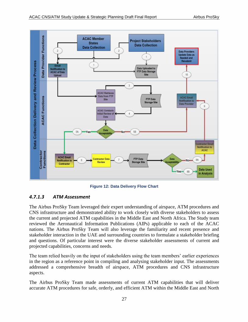
ACAC CNS/ATM Study Update & Strategic Planning Draft Final Report Airbus ProSky
27
Figure 12: Data Delivery Flow Chart
4.7.1.3 ATM Assessment
The Airbus ProSky Team leveraged their expert understanding of airspace, ATM procedures and
CNS infrastructure and demonstrated ability to work closely with diverse stakeholders to assess
the current and projected ATM capabilities in the Middle East and North Africa. The Study team
reviewed the Aeronautical Information Publications (AIPs) applicable to each of the ACAC
nations. The Airbus ProSky Team will also leverage the familiarity and recent presence and
stakeholder interaction in the UAE and surrounding countries to formulate a stakeholder briefing
and questions. Of particular interest were the diverse stakeholder assessments of current and
projected capabilities, concerns and needs.
The team relied heavily on the input of stakeholders using the team members’ earlier experiences
in the region as a reference point in compiling and analysing stakeholder input. The assessments
addressed a comprehensive breadth of airspace, ATM procedures and CNS infrastructure
aspects.
The Airbus ProSky Team made assessments of current ATM capabilities that will deliver
accurate ATM procedures for safe, orderly, and efficient ATM within the Middle East and North
ACAC CNS/ATM Study Update & Strategic Planning Draft Final Report Airbus ProSky
28
Africa while considering the needs/limitations of the stakeholder community. Focus areas will
include but not be limited to:
ATM – current operating procedures and agreements with surrounding ANSPs and FIR
flight operators, flow rates internal and adjacent within the Middle East and North Africa,
regional constraints and their mitigation planning, intra-/inter-facility ATM
communication and data exchange capabilities, and ATM decision support tools (DSTs).
CNS Infrastructure – operating and technological constraints within communications,
navigation, and surveillance capabilities within the Middle East and North Africa FIRs
that are affecting adjacent FIR operations.
Following the stakeholder sessions, we analysed the information from the stakeholder sessions
combined with information from reference reports and plans. A briefing was generated and
presented to the ACAC prior to starting the subsequent Gap Analysis Phase. The briefing to the
ACAC Team present, with the general team participating by TELCON.
4.7.1.4 Gap Analysis / Findings
Key to a gap analysis is deciding on the points in time the gap will be assessed against. The
Airbus ProSky Team proposed to base the gap assessment on current capabilities and compare
those to ICAO Block Update 1, 2 and 3 capabilities and timeframes. The gap analysis provided
assessments in terms of the major element identified in the approach section of the proposal as
applicable to all phases of the study. In performing the gap analysis, two factors were be
considered primary and cannot be compromised; specifically safety and security.
The Airbus ProSky Team evaluated gaps in capabilities to meet forecasted activity demand and
expected ABSU functionality using a need – capability model similar to that shown in Figure 13.

ACAC CNS/ATM Study Update & Strategic Planning Draft Final Report Airbus ProSky
29
Figure 13: Growth – Capability Model
The assessment included a Comparative Analysis relative to:
• Global Best Practices as derived from various aviation domains
• GANP and supports ASBUs
Airbus ProSky Team compiled the output from our experts’ observations and stakeholder
consultations into a complete study describing an assessment of current Middle East ATM and
North Africa, gap analysis and recommendations for optimisation. We deliver the study to the
ACAC and other stakeholders through interim updates and as a draft and final version.
The following references were used to identify dependencies between the capability needs and
related technologies and processes, see Table 7:
1. ICAO ASBU
2. ACAC ATM Study Final Report recommendations
3. Middle East and North Africa ATM planning documentation
4. Checklist of items projected to be of specific interest to the ACAC are identified below:
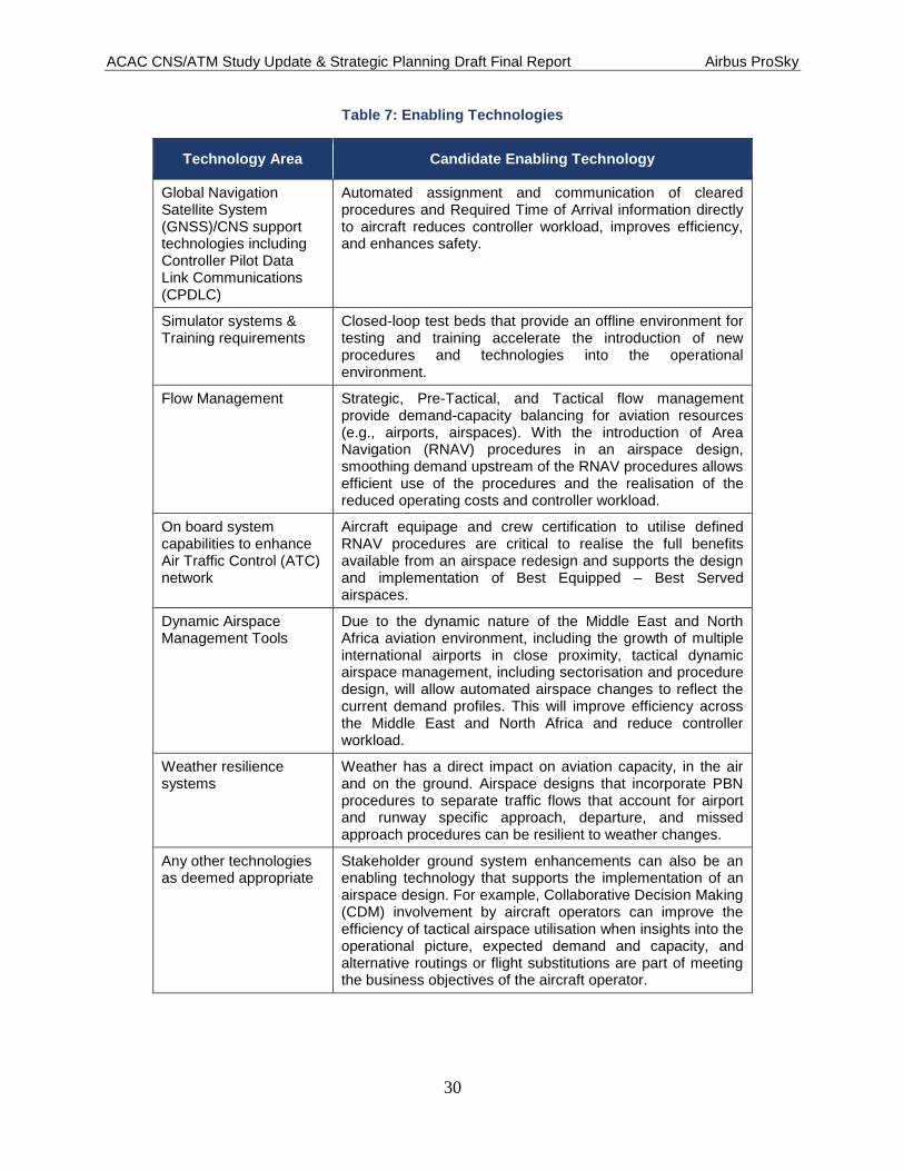
ACAC CNS/ATM Study Update & Strategic Planning Draft Final Report Airbus ProSky
30
Table 7: Enabling Technologies
Technology Area Candidate Enabling Technology
Global Navigation Satellite System (GNSS)/CNS support technologies including Controller Pilot Data Link Communications (CPDLC)
Automated assignment and communication of cleared procedures and Required Time of Arrival information directly to aircraft reduces controller workload, improves efficiency, and enhances safety.
Simulator systems & Training requirements
Closed-loop test beds that provide an offline environment for testing and training accelerate the introduction of new procedures and technologies into the operational environment.
Flow Management Strategic, Pre-Tactical, and Tactical flow management provide demand-capacity balancing for aviation resources (e.g., airports, airspaces). With the introduction of Area Navigation (RNAV) procedures in an airspace design, smoothing demand upstream of the RNAV procedures allows efficient use of the procedures and the realisation of the reduced operating costs and controller workload.
On board system capabilities to enhance Air Traffic Control (ATC) network
Aircraft equipage and crew certification to utilise defined RNAV procedures are critical to realise the full benefits available from an airspace redesign and supports the design and implementation of Best Equipped – Best Served airspaces.
Dynamic Airspace Management Tools
Due to the dynamic nature of the Middle East and North Africa aviation environment, including the growth of multiple international airports in close proximity, tactical dynamic airspace management, including sectorisation and procedure design, will allow automated airspace changes to reflect the current demand profiles. This will improve efficiency across the Middle East and North Africa and reduce controller workload.
Weather resilience systems
Weather has a direct impact on aviation capacity, in the air and on the ground. Airspace designs that incorporate PBN procedures to separate traffic flows that account for airport and runway specific approach, departure, and missed approach procedures can be resilient to weather changes.
Any other technologies as deemed appropriate
Stakeholder ground system enhancements can also be an enabling technology that supports the implementation of an airspace design. For example, Collaborative Decision Making (CDM) involvement by aircraft operators can improve the efficiency of tactical airspace utilisation when insights into the operational picture, expected demand and capacity, and alternative routings or flight substitutions are part of meeting the business objectives of the aircraft operator.

ACAC CNS/ATM Study Update & Strategic Planning Draft Final Report Airbus ProSky
31
The collection of enabling policy, procedures, technologies, and processes and corresponding
availability supported the final report development. Based on the criticality of various ATM
capabilities or dependence on an enabling policy, procedure, technology, or process, alternative
policy, procedures, technologies, and capabilities may be evaluated to reduce the implementation
risk.
The Airbus ProSky Team followed a similar process as for the requirements and design segments
of the project by first collecting relevant data and obtaining input and buy-in from stakeholders.
The Airbus ProSky Team integrated transition approach, policy implications, and enabling
capabilities into the final report.
4.7.2 Final Report
The Airbus ProSky Team developed an integrated Final Report containing pertinent information
from the previous deliverables. The draft of the report was provided to ACAC review prior to the
completion of the contract period of performance.
Different from other report deliverables, the Airbus ProSky Team expected that the Final Report
may require coordination with higher organisational levels; as a result, it may take a few weeks
longer to provide the team with comments. Once those comments are received, the Airbus
ProSky Team updated this Final Report.
4.7.3 Stakeholder and Executive Presentation
The Airbus ProSky Team proposed that the project not stop with the production of the Final
Report. We recommended that appropriate presentations be developed for stakeholders and
executives. We would be pleased to support those presentations if so requested by the ACAC.
4.7.3.1 Stakeholder Presentation
Understanding the importance of stakeholder involvement to the ACAC, the Airbus ProSky
Team proposed to close the collaboration loop with stakeholders to address how their input was
reflected in the Final Report. We recommended that consideration also be given to making the
presentation’s key aspects available throughout the Middle East and North Africa civil aviation
authorities, ANSPs, and stakeholder representative organisations.

ACAC CNS/ATM Study Update & Strategic Planning Draft Final Report Airbus ProSky
32
5 Stakeholder Consultation
From the onset of this study update, stakeholder interaction and support have been identified as
two of the most critical factors in identifying and collecting the necessary data to successfully
advance this project. Realizing the project constraints (time and resources), the project team
supplemented ACAC Member State provided data with recently collected data from regional air
traffic control and air traffic management in support of a major UAE regional ATM airspace and
procedure redesign effort. This leveraging of information assisted the project team by providing
a highly detailed perspective of a segment of the overall ACAC jurisdictional environment.
In both cases, the ACAC overall region and the UAE localised, questionnaires were a major
source of information and when possible supplemented with on-site work group and work shop
activities, with the latter being more prevalent within the localised UAE project (which included
the countries of – UAE [and its major flight operators – Emirates Airlines and Etihad Airways],
Bahrain, Oman, Qatar, and Saudi Arabia). In neither case, was information provided from any
military authority.
Operator representation was sought, and support was offered by the largest regional ACAC
operator representative body – the Arab Air Carriers Organization (AACO). To leverage this
unique opportunity a separate operator focused questionnaire was developed to obtain significant
first-hand information, from a customer perspective, on ACAC FIR service availability and its
delivery. This parallel organisational and operational environment provided a natural nexus of
the service provider and the service customer where exchanges of meaningful project
information could be obtained, the unique jurisdictional overlap is illustrated in Figure 14. The
questions developed were intended to provide the project contract team with the necessary data
needed to obtain an overall customer perspective of ATC operations and flow management
within the ACAC region. Unfortunately, no responses were provided. The questionnaire was and
is available online through the AACO website: www.acac.org.ma
Figure 14: Jurisdictional Overlap

ACAC CNS/ATM Study Update & Strategic Planning Draft Final Report Airbus ProSky
33
Table 8 depicts the outreach timelines used for both the ACAC CNS-ATM Study Update and the
UAE Airspace and Procedure Redesign.
Table 8: ACAC and other Regional Stakeholder Outreach Timelines
ACAC and other Regional Stakeholder Outreach Efforts
Meeting Type Primary
Stakeholders Type Activity Dates
On-Site
ACAC Organization CNS-ATM Study Objectives and Status
Update
14 December 2015
Teleconference ACAC Mgmt. Data Collection Status Update Meetings
Periodic
Teleconference ACAC Mgmt. ATM Assessment Briefing
18 March 2016
On-site ACAC Organization CNS-ATM Study Workshop - Data
Gathering & Confirmation Activities
7 April 2016
On-site ACAC Organization Presentation 7 April 2016
UAE Regional Stakeholder Outreach Efforts
On-site SZC, Project Technical Team (PTT), National
Aviation Stakeholder
Advisory Committee (NASAC)
Work Groups & Work Shops
Multiple 2015
On-site SZC, DANS, ADAC, GCAA,
Data Gathering & Requirements Identification
Multiple 2015
On-site SZC, PTT Data Gathering & Requirements Identification
Multiple 2015
On-site SZC, Airbus ProSky Development Activities Multiple 2015
On-site Bahrain Regional Data Gathering
24 March 2015
On-site Oman Regional Data Gathering
24 March 2015

ACAC CNS/ATM Study Update & Strategic Planning Draft Final Report Airbus ProSky
34
ACAC and other Regional Stakeholder Outreach Efforts
Meeting Type Primary
Stakeholders Type Activity Dates
On-site Qatar Regional Data Gathering
29 March 2015
Teleconference Saudi Arabia Regional Data Gathering
19 May 2015
On-site SZC, PTT Work Shop - Review, Affirmation and Advancement
Multiple 2015
5.1 Stakeholder Data Availability Impacts
Assessment outcome is directly linked to (1) input provided by ACAC member states through
the use of a questionnaire, (2) extensiveness of data provided, and (3) the availability of publicly
accessible data. A careful review was conducted of the data supplied, when it was received and
available public source data. As a result, judgments were required by the contract team to
determine which FIRs provided sufficient and effective data in order to be able to conduct a
timely and meaningful analysis.
Table 9 depicts which States were included in the study and which were not as determined using
the criteria noted below:
Category 1 States - those States included in the study
Category 2a States - those States not included in the study due to data being submitted
beyond the March 18, 2016 cut-off date
Category 2b States - those States not included as they did not submit data
NOTE: The Category 2a supplied data is being retained by the study team, and if there were a
timely resource modification during the 2-3 month ACAC review period, those category 2a
States could have their data analysed and added to the overall project study.

ACAC CNS/ATM Study Update & Strategic Planning Draft Final Report Airbus ProSky
35
Table 9: State Study Inclusion Status
State Study Inclusion Status
Category 1 Category 2a Category 2b
Algeria Oman Tunisia Iraq
Bahrain Palestine Mauritania Jordan
Egypt Qatar Kuwait
Lebanon Saudi Arabia
Libya
Morocco Sudan Syria
UAE Yemen
Table 10 indicates the responses obtained for both the initial and supplemental questionnaires
and the effectiveness of the data provided.

ACAC CNS/ATM Study Update & Strategic Planning Draft Final Report Airbus ProSky
36
Table 10: FIR Data Response Status
Initial Questionnaire (Part #s) Supplemental Questionnaire (Section #s)
ACAC State I II III IV 3 4 5 6 7 8 9 10 11 12 13 14 15
Algeria DP DP P P P DP DP DP DP P P DP DP DP P P P
Bahrain ND ND ND ND P DP DP DP DP DP DP DP DP DP DP DP P
Egypt DP DP DP P DP DP DP DP DP P DP DP DP DP DP DP DP
Iraq ND ND ND ND ND ND ND ND ND ND ND ND ND ND ND ND ND
Jordan ND ND ND ND ND ND ND ND ND ND ND ND ND ND ND ND ND
Kuwait ND ND ND ND ND ND ND ND ND ND ND ND ND ND ND ND ND
Lebanon ND ND ND ND P DP P P DP DP DP DP DP DP DP DP DP
Libya ND ND ND ND ND ND ND ND ND ND ND ND ND ND ND ND ND
Mauritania DP DP DP DP DP DP DP P DP DP ND P DP P DP DP ND
Morocco DP DP DP DP ND ND ND ND ND ND ND ND ND ND ND ND ND
Oman DP DP DP DP DP DP DP DP DP DP DP DP DP DP DP DP DP
Palestine P P P P P P P P P P P P P P P P P
Qatar DP DP DP DP P DP DP DP DP DP DP P DP P DP DP DP
Saudi Arabia
DP DP P DP DP DP P DP DP DP DP DP DP DP DP DP DP
Sudan ND ND ND ND DP DP DP P DP P P DP DP P P DP P
Syria ND ND ND ND ND ND ND ND ND ND ND ND ND ND ND ND ND
Tunisia DP DP DP P P DP DP DP DP P DP DP DP DP DP DP DP
UAE* DP DP DP DP DP* DP* DP* DP* DP* DP* DP* DP* DP* DP* DP* DP* DP*
Yemen ND ND ND ND ND ND ND ND ND ND ND ND ND ND ND ND ND
Data Status: DP – Data Provided, P – Partial Data Provided, ND – No Data Provided *Data derived from UAE airspace redesign project.

ACAC CNS/ATM Study Update & Strategic Planning Draft Final Report Airbus ProSky
37
Category 1 and 2 States are illustrated in Figure 15 graphically depicting the study area.
Figure 15: Category 1 and 2 State Illustration

ACAC CNS/ATM Study Update & Strategic Planning Draft Final Report Airbus ProSky
38
6 Assessment Process and Criteria
This section describes the process and criteria that were used to assess the FIRs.
6.1 Assessment Process
The assessment process consisted of three core activities; (1) data identification and collection,
(2) data processing, and (3) assessment of data. The process is depicted in Figure 16 in
section 6.1.3.
6.1.1 Data Identification and Collection:
The assessment process commenced with activities that would determine the identification of the
type of data required, a review of where that data resides, and the development of a method of
retrieving that data. The output of this process indicated that operational, analytical, and
administrative data from each ACAC Member State FIR would be required. Data types would
include but not be limited to; operation communication, navigation, and surveillance,
ATM/ATFM, automation, separation, airspace, staffing and capacity.
The process to collect the identified data from the ACAC Member States was constrained by the
scope of the project contract, and thus required the extensive use of indirect and time consuming
methods to accomplish the task.
Data collection was obtained by way of stakeholder input through a questionnaire. Initially, one
questionnaire was developed; however, with the scope of this project not including direct
stakeholder interface, the project contractor in consultation with ACAC decided as an
appropriate course of action to supplement that initial questionnaire with another to solicit
greater detail covering more subject matter. For the purposes of this project the two
questionnaires are referred to as the ‘initial questionnaire’ and the ‘supplemental questionnaire’.
Both questionnaires are available through ACAC as companion documents to this report. In
addition to questionnaire supplied data, the project team derived additional data from publically
available sources and used it to help augment missing or insufficient data provided by
questionnaire respondents.
6.1.2 Data Processing:
The processing activity commenced using the data collected from the; (1) Initial Questionnaire,
(2) Supplemental Questionnaire, and (3) data derived through publically available sources which
include (a) ICAO directives, (b) ICAO regional work group meeting minutes, (c) aviation
industry documentation, and (d) other aggregated data that was used to develop project team
country profiles (contained in companion document titled ACAC Final Report Supplement ATC
Country Profiles). Core to the data processing phase was the identification of regional
operational and administrative requirements and guidelines that define and recommend
operational processes and service provisions for the ACAC regions’ (Africa and Middle East)
ANSPs. These requirements are listed in great detail in the following sections (6.1.3 and 6.2).

ACAC CNS/ATM Study Update & Strategic Planning Draft Final Report Airbus ProSky
39
6.1.3 Data Assessment:
As the process in Figure 16 shows, the assessment process provides, at a regional perspective,
the regions’; (1) requirements (general and specific), and (2) needed service provision, compared
to the regions’ current and future abilities and capabilities to comply and support those
requirements and services. Additionally, to the extent that data was provided and analysis could
substantive, a quality of service level was provided.
Assessment outcome is directly linked to (1) input provided by ACAC member states through
the use of the questionnaires, (2) extensiveness of the questionnaire data provided, and (3) the
availability of publicly accessible data.
Figure 16: Assessment Process
ACAC CNS/ATM Study Update & Strategic Planning Draft Final Report Airbus ProSky
40
6.2 Assessment Criteria: ICAO Technological and Procedural Requirements
A major element in conducting the assessment of the current operation was to gather and
compare the ICAO and Regional Sub-Group requirements and guidelines as they pertain to the
core operational topics of communication, navigation, surveillance, automation, and air traffic
management. These requirements and guidelines were collected from sources which include:
MIDeANP, CNS Sub Group Reports, GANP, CANSO key performance indicators (KPIs), etc.
The operational topics were further sub-divided, although not uniformly and across all
operational topics, into sections that included categories:
1. General Regional Requirements
2. Specific Requirements
3. Current Provided Services
4. Current Capabilities
5. Quality of Services
The following sections describe the criteria utilised by the Study Team to assess each State’s
current capability and quality of services provided in the areas of Communication; Navigation;
Surveillance and Automation and Air Traffic Management.
6.2.1 Communications
6.2.1.1 General Regional Communications Requirements
Aeronautical Fixed Service (AFS)
The aeronautical fixed service (AFS) should satisfy the communication requirements of ATS,
AIS/AIM, Meteorological Services for Air Navigation (MET) and Search and Rescue (SAR),
including specific requirements in terms of system reliability, message integrity and transit times,
with respect to printed as well as digital data and speech communications. If need be, it should,
following agreement between individual States and aircraft operators, satisfy the requirements
for airline operational control.
The Aeronautical Telecommunication Network (ATN)
The ATN of the Region(s) should have sufficient capacity to meet the minimum requirements for
data communications for the services mentioned above and be able to support:
a. Applications carried by the existing networks;
b. Gateways enabling inter-operation with existing networks; and
c. Ground-ground communications traffic associated with air-to-ground (A/G) data link
applications.
Aeronautical Mobile Service (AMS)
Air-to-ground communications facilities should meet the agreed communication requirements of
the air traffic services (ATS), as well as all other types of communications which are acceptable
on the AMS to the extent that the latter types of communications can be accommodated.

ACAC CNS/ATM Study Update & Strategic Planning Draft Final Report Airbus ProSky
41
Air-to-ground communications for ATS
Air-to-ground communications for ATS purposes should be so designed to require the least
number of frequency and channel changes for aircraft in flight compatible with the provision of
the required service. They should also provide for the minimum amount of coordination between
ATS units and provide for optimum economy in the frequency spectrum used for this purpose.
Air-to-ground data link communications
Air-to-ground data link communications should be implemented in such a way that they are
regionally and globally harmonised and make efficient use of available communication means
and ensure optimum economy in frequency spectrum use and system automation.
Contingency planning
States should prepare their contingency plans in advance and ensure their availability or
accessibility to the ICAO Regional Office. The plans should be reviewed at regular intervals and
updated as required.
6.2.1.2 Specific Regional Communications Requirements
Aeronautical Fixed Service (AFS)
Where ATS speech and data communication links between any two points are provided, the
engineering arrangements should be such as to avoid the simultaneous loss of both circuits.
Special provisions should be made to ensure a rapid restoration of ATS speech circuits in case of
outage, as derived from the performance and safety requirements.
Data circuits between ATS systems should provide for both high capacity and message integrity.
The Inter-Centre Communication (ICC), consisting of ATS Inter-facility Data Communication
(AIDC) application and the Online Data Interchange (OLDI) application, should be used for
automated exchange of flight data between ATS units to enhance the overall safety of the ATM
operation and increase airspace capacity.
Specific Meteorological (MET) requirements
In planning the ATN, account should be taken of changes in the current pattern of distribution of
meteorological information resulting from the increasing number of long-range direct flights and
the trend towards centralised flight planning.
Specific Aeronautical Information Management (AIM) requirements
The aeronautical fixed service should meet the requirements to support efficient provision of
aeronautical information services (AISs) through appropriate connections to area control centres
(ACCs), flight information centres (FICs), aerodromes and heliports at which an information
service is established.
ACAC CNS/ATM Study Update & Strategic Planning Draft Final Report Airbus ProSky
42
Specific Aeronautical Mobile Service (AMS) requirements
A high-grade aeronautical network should be provided based on the ATN, recognizing that other
technologies may be used as part of the transition. The network needs to integrate the various
data links in a seamless fashion and provide for end-to-end communications between airborne
and ground-based facilities.
Aerodromes having a significant volume of International General Aviation (IGA) traffic should
also be provided with appropriate air-to-ground communication channels.
States should ensure that no air/ground frequency is utilised outside its designated operational
coverage and that the stated operational requirements for coverage of a given frequency can be
met for the transmission sites concerned, taking into account terrain configuration.
Aeronautical Fixed Service (AFS)
Where ATS speech and data communication links between any two points are provided, the
engineering arrangements should be such as to avoid the simultaneous loss of both circuits.
Special provisions should be made to ensure a rapid restoration of ATS speech circuits in case of
outage, as derived from the performance and safety requirements.
Data circuits between ATS systems should provide for both high capacity and message integrity.
The Inter-Centre Communication (ICC), consisting of ATS Inter-facility Data Communication
(AIDC) application and the Online Data Interchange (OLDI) application, should be used for
automated exchange of flight data between ATS units to enhance the overall safety of the ATM
operation and increase airspace capacity.
Specific Meteorological (MET) requirements
In planning the ATN, account should be taken of changes in the current pattern of distribution of
meteorological information resulting from the increasing number of long-range direct flights and
the trend towards centralised flight planning.
Specific Aeronautical Information Management (AIM) requirements
The aeronautical fixed service should meet the requirements to support efficient provision of
aeronautical information services through appropriate connections to area control centres
(ACCs), flight information centres (FICs), aerodromes and heliports at which an information
service is established.
Specific Aeronautical Mobile Service (AMS) requirements
A high-grade aeronautical network should be provided based on the ATN, recognizing that other
technologies may be used as part of the transition. The network needs to integrate the various
data links in a seamless fashion and provide for end-to-end communications between airborne
and ground-based facilities.
Aerodromes having a significant volume of International General Aviation (IGA) traffic should
also be provided with appropriate air-to-ground communication channels.
ACAC CNS/ATM Study Update & Strategic Planning Draft Final Report Airbus ProSky
43
States should ensure that no air/ground frequency is utilised outside its designated operational
coverage and that the stated operational requirements for coverage of a given frequency can be
met for the transmission sites concerned, taking into account terrain configuration.
6.2.1.3 Current Aeronautical Telecommunication/Datalink Provided Services
Classification of the aeronautical telecommunication services supporting Air Traffic Services are
categorised by (1) ground-based stations and (2) satellite-based services, and are defined below.
Aeronautical Broadcasting Service
A broadcasting service intended for the transmission of information relating to air navigation.
Aeronautical Fixed Service
A telecommunication service between specified fixed points provided primarily for the safety of
air navigation and for the regular, efficient and economical operation of air services that include:
a. ATS direct speech circuits and networks;
b. Meteorological operational circuits, networks and broadcast systems, including World
Area Forecast System – Internet File Service (WAFS WIFS) and/or Satellite Distribution
System for Information Relating to Air Navigation (SADIS);
c. The aeronautical fixed telecommunications network (AFTN);
d. The common ICAO data interchange network (CIDIN);
e. The air traffic services (ATS) message handling services (AMHS); and
f. The inter-centre communications (ICC).
Aeronautical Fixed Telecommunication Network Service
A worldwide system of aeronautical fixed circuits provided, as part of the aeronautical fixed
service, for the exchange of messages and/or digital data between aeronautical fixed stations
having the same or compatible communication characteristics.
Aeronautical Telecommunication Network Service
An inter-network that allows ground, air ground and avionics data sub-networks to inter-operate
by adopting common interface services and protocols based on the International Organization for
Standardization (ISO) Open Systems Interconnect (OSI) reference model.
Aeronautical Mobile Service
A mobile service between aeronautical ground stations and aircraft stations, in which survival
craft stations may participate; emergency position-indicating radio beacon stations may also
participate in this service on distress and emergency frequencies. This service does not include
ground stations that are provided for other than ATS purposes.
ACAC CNS/ATM Study Update & Strategic Planning Draft Final Report Airbus ProSky
44
Other
Any telecommunication service which processes or displays air traffic control data (including
aviation meteorological data) for use by an ATS provider.
6.2.1.4 Current Aeronautical Telecommunication/Datalink Facilities
Classification of Facilities (Capabilities)
The following list classifies the kinds of aeronautical telecommunication facilities used that meet
the general/specific regional requirements. The data received from the State questionnaires will
be compared and evaluated to assess these facilities.
Facilities (Capabilities)
1. Very-high frequency (VHF) air/ground voice communication facilities/coverage and
overlap;
2. Ultra-high frequency (UHF) air/ground voice communication facilities/coverage and
overlap;
3. High-frequency (HF) air/ground voice communication facilities/coverage overlap;
4. Emergency back-up capabilities;
5. ATS point to point communication facilities;
6. Ground to ground data interchange networks AMHS capable / interconnected [ATS
Messaging Handling System]);
7. Inter/intra facility operational procedures;
8. SAR Agreements with surrounding facilities;
9. Harmonised Inter/intra-facility communications capability;
10. CPDLC capabilities - Air/ground data links;
11. AIDC/OLDI Capable / Implemented;
12. Human Machine Interface systems, including Tower Consoles, ATS Work Stations, and
Display facilities;
13. Uninterruptible and emergency power supplies;
14. Essential systems are contained in buildings and in equipment shelters housing facilities
(electrical power supplies, air-conditioning, and security facilities);
15. Available maintenance and restoration facilities;
16. Maintenance and restoration documentation processes;
17. Spectrum analysis procedures are in place;
18. Adjacent facility interoperability procedures/agreements;
ACAC CNS/ATM Study Update & Strategic Planning Draft Final Report Airbus ProSky
45
6.2.1.5 Current Aeronautical Telecommunication/Datalink Quality of Services
Quality of Services
The following list classifies the kinds of aeronautical telecommunication services provided that
meets the general regional/specific requirements. The data received from the State questionnaires
will be compared and evaluated to assess the quality of these services.
Services
1. VHF air/ground voice communication quality performance;
2. UHF air/ground voice communication quality performance;
3. HF air/ground voice communication quality performance;
4. Minimal number of frequency changes;
5. Acceptable number of inter-intra facility ATC coordination communication lines;
6. Acceptable data link and land line latency;
7. Documented communications procedures (nominal and contingency use and
maintenance);
8. Timeliness and accuracy of MET data reception;
9. Timeliness and accuracy of MET data analysis and impact translation;
10. SAR support procedures in place;
11. Operational impact to services resulting from interoperability agreements/procedures;
12. Operational impact to services resulting from LACK of interoperability
agreements/procedures;
6.2.2 Navigation
6.2.2.1 General Regional Navigation Requirements
Navigation
Planning of aeronautical radio navigation services should be done on a total system basis, taking
full account of the navigation capabilities as well as cost effectiveness. The total system
composed of station-referenced navigation aids, satellite-based navigation systems and airborne
capabilities should meet the performance-based navigation (PBN) requirements for all aircraft
using the system and should form an adequate basis for the provision of positioning, guidance
and air traffic services.
Account should be taken of the fact that certain aircraft may be able to meet their navigation
needs by means of self-contained or satellite-based aids, thus eliminating the need for the
provision of station-referenced aids along the ATS routes used by such aircraft, as well as the
need to carry on board excessive redundancies.

ACAC CNS/ATM Study Update & Strategic Planning Draft Final Report Airbus ProSky
46
Navigation Infrastructure
The navigation infrastructure should meet the requirements for all phases of flight from take-off
to final approach and landing. Note: Annex 10 to the Convention on International Civil
Aviation—Aeronautical Telecommunications, Volume I — Radio Navigation Aids, Attachment
B, provides the strategy for introduction and application of non-visual aids to approach and
landing.
Reference: The MID Region PBN Implementation Plan provides guidance to air navigation
service providers, airspace operators and users, regulators, and international organisations, on the
expected evolution of the regional air navigation system in order to allow planning of airspace
changes, enabling ATM systems and aircraft equipage. It takes due account of the operational
environment of the MID Region.
PBN Transition Strategy
During transition to performance-based navigation (PBN),
Sufficient ground infrastructure for conventional navigation systems should remain
available. Before existing ground infrastructure is considered for removal.
Users should be given reasonable transition time to allow them to equip appropriately to
attain a performance level equivalent to PBN.
States should approach removal of existing ground infrastructure with caution to ensure
that safety is not compromised.
This should be guaranteed by conducting safety assessments and consultations with the
users.
Use of specific navigation aids
Where, within a given airspace, specific groups of users have been authorised by the competent
authorities to use special aids for navigation. The respective ground facilities should be located
and aligned so as to provide for full compatibility of navigational guidance with that derived
from the Standards and Recommended Practices (SARPs).
States should ensure and oversee that service providers take appropriate corrective measures
promptly whenever required by a significant degradation in the accuracy of navigation aids
(either space-based or ground-based, or both) is detected.
NAVAID Frequency Usage
Special provisions should be made, by agreement between the States concerned, for the sharing
and the application of reduced protection of non-ATS frequencies in the national sub-bands, so
as to obtain a more economical use of the available frequency spectrum consistent with
operational requirements.
States should ensure that no air/ground frequency is utilised outside its designated operational
coverage and that the stated operational requirements for coverage of a given frequency can be
met for the transmission sites concerned, taking into account terrain configuration. Radio
navigation aids for Aeronautical Radio Navigation Services (ARNS)

ACAC CNS/ATM Study Update & Strategic Planning Draft Final Report Airbus ProSky
47
Frequencies should be assigned to all radio navigation facilities taking into account agreed
geographical separation criteria to Instrument Landing System (ILS) localiser, VOR and GBAS,
X and Y channels to DME, in accordance with the principles laid out in Annex 10, Volume V
and ICAO Handbook on Radio Frequency Spectrum Requirements for Civil Aviation (Doc
9718) Volumes I and II. Also, the need for maximum economy in frequency demands and in
radio spectrum utilisation and a deployment of frequencies which ensures that international
services are planned to be free of interference from other services using the same band, need to
be considered.
The principles used for frequency assignment planning for radio navigation aids serving
international requirements should, to the extent possible, also be used to satisfy the needs for
national radio aids to navigation.
Visual aids for low-visibility aerodrome operations
At aerodromes where there is a requirement to conduct low-visibility operations, the appropriate
visual and non-visual aids should be provided.
Non-precision approach aids
Where required by the topographic and/or environmental situation of an aerodrome, improved
track guidance during departure and/or approach by specific non-visual and/or visual aids should
be provided even if such aids would not normally be required in accordance with the SARPs.
Evaluating GNSS vulnerabilities
Ground- and space-based NAVAIDs should be free from Intentional or unintentional
interference.
States should assess the GNSS vulnerability in their airspace and select appropriate mitigations
depending on the airspace in question and the operations that must be supported. These
mitigations can ensure safe operations and enable States to avoid the provision of new terrestrial
navigation aids, reduce existing terrestrial navigation aids, and discontinue them in certain areas.
There are three principal aspects to be considered in the evaluation of GNSS vulnerabilities.
a. Interference and atmospheric (ionosphere) effects are of primary concern. Operational
experience is the best way to assess the likelihood of unintentional interference. Each
State must consider the motivation to intentionally interfere with GNSS based on the
potential safety and economic impacts on aviation and non-aviation applications.
Atmospheric effects are unlikely to cause a total loss (outage) of GNSS but may impact
some services (e.g., approaches with vertical guidance in equatorial regions). The
likelihood of specific effects can be categorised as negligible, unlikely or probable.
b. All operations and services dependent on GNSS should be identified and considered
together, since GNSS interference can potentially disrupt all GNSS receivers at the same
time over a certain area. GNSS is used for navigation services as well as other services
such as precision timing with communications and radar systems, and may also be used
for Automatic Dependent Surveillance (ADS) services. In these cases, GNSS represents a
potential common point of failure.
ACAC CNS/ATM Study Update & Strategic Planning Draft Final Report Airbus ProSky
48
c. The impact of a GNSS outage on an operation or service should be assessed by
considering the types of operations, traffic density, availability of independent
surveillance and communications and other factors. The impact can be categorised as
none, moderate or severe.
By considering these aspects as a function of airspace characteristics, air navigation service
providers can determine whether mitigation is required and, if so, at what level.
System Responsiveness
States should ensure and oversee that service providers take appropriate corrective measures
promptly whenever required by a significant degradation in the accuracy of navigation aids
(either space-based or ground-based, or both) is detected.
6.2.2.2 Specific Regional ATM Requirements
States should develop a Corrective Action Plan (CAP) for each air navigation deficiency.
6.2.2.3 Current Navigation Provided Services
Services provided to air traffic during all phases of operations including air traffic management,
communication, navigation and surveillance, meteorological services for air navigation, search
and rescue and aeronautical information services.
Provision of air navigation services comprised of:
Ground-based radio navigation equipment (e.g., VOR, TACAN, DME and NDB),
Precision approach and landing aids (e.g., ILS equipment)
GNSS (GPS) capability that enables all non-precision approaches to be flown as
“precision-like” approaches
Runway and Approach (instrument and visual) Lighting Systems - Airport lighting
systems (e.g., Approach, Precision Approach Path Indicators, Visual Approach Slope
Indicator, Runway, Runway End Identifier Lights, Taxiway)
Airport Markings – Precision and Non-Precision surface markings
6.2.2.4 Current Navigation Facilities (Capabilities)
Classification of Facilities (Capabilities)
The following list classifies the kinds of Navigation facilities (capabilities) used that meet the
general/specific regional requirements. The data received from the State questionnaires will be
compared and evaluated to assess these facilities.
Facilities (Capabilities)
1. Airport Instrument Landing Systems;
2. Airport Visual Landing Systems;
3. Airport Lighting Systems;

ACAC CNS/ATM Study Update & Strategic Planning Draft Final Report Airbus ProSky
49
4. Airport Ground-Based Navigation Systems (e.g., VOR, DME, TACAN, NDB);
5. En Route Ground-Based Navigation Systems (e.g., VOR, TACAN, DME, NDB);
6. Published Approach/Departure Procedure;
7. System Status Monitoring Capabilities;
8. System outage or service limitation notification process (e.g., NOTAM);
9. Documented System Restoration Procedures;
10. Documented System Outage/Restoration Metrics and Analysis;
11. Uninterruptible and emergency power supplies;
12. Essential services in buildings and in equipment shelters housing facilities providing
adequate security and weather avoidance (electrical power supplies, air-conditioning,
and security facilities);
13. System Failure or Degradation Contingency Planning;
6.2.2.5 Current ATM Quality of Services
Quality of Services
The following list classifies the kinds of Navigation services provided that meets the general
regional/specific requirements. The data received from the State questionnaires will be compared
and evaluated to assess the quality of these services.
Services
1. NAVAIDs are operating within specified service volumes;
2. NAVAIDs operating outside of specified service volumes are doing so with appropriate
expanded services volume approvals and flight checks;
3. System outages or service limitations are published in a timely manner for stakeholder
notification and planning;
4. Appropriate navigational guidance and coverage is available to stakeholders from take-
off to landing;
5. Services are available and provided to stakeholders in an open and non-restrictive
manner;
6. Procedures are developed in a collaborative manner with stakeholders;
7. Formalised procedures are documented and available to stakeholders;
8. System restoration is accomplished within acceptable time parameters identified by FIR;
ACAC CNS/ATM Study Update & Strategic Planning Draft Final Report Airbus ProSky
50
6.2.3 Surveillance
6.2.3.1 General Regional Surveillance Requirements
Surveillance
Planning of aeronautical surveillance systems should be made based on a system approach
concept, where collaboration and sharing of data sources should be considered in support of an
efficient use of the airspace. An important element of modern air navigation infrastructure
required managing safely increasing levels and complexity of air traffic is aeronautical
surveillance systems.
System Approach
Planning of surveillance systems should be made based on a system approach concept, where
collaboration and sharing of data sources should be considered in support of an efficient use of
the airspace.
Surface Surveillance
At each international aerodrome, specific minima visibility for take-off should be established,
regulating the use of intersection take-off positions. These minima should permit the appropriate
ATC unit to maintain a permanent surveillance of the ground movement operations, and the
flight crews to constantly secure their position on the manoeuvring area, so as to exclude any
potential risk of confusion as to the identification of the aircraft and intersections used for take-
off. The minima should be consistent with the surface movement guidance and control system
(SMGCS) provided at the aerodrome concerned.
Beacon Code Management
When operating Mode S radars, States should coordinate with their respective ICAO Regional
Office the assignment of their corresponding interrogator identifier (II) codes and surveillance
identifier (SI) codes, particularly where areas of overlapping coverage will occur.
Surveillance Harmonisation
States should ensure that implementation of Surveillance technologies are harmonised,
compatible and interoperable with respect to operational procedures, supporting data link and
ATM applications.
Surveillance Capacity Improvements
Surveillance Improvement
There is a need to encourage the application of improved surveillance techniques that will
reduce separation minima, enhance safety, increase capacity, and improve flight efficiency
in a cost-effective manner. These benefits can be achieved by providing surveillance in
areas that lack primary or secondary radar, when profitability models warrant it. In
airspaces with radar coverage, improved surveillance could further reduce separation
minima between aircraft and, in areas with high traffic density; it could improve the quality
of surveillance information both on the ground and in the air, thus increasing safety levels.

ACAC CNS/ATM Study Update & Strategic Planning Draft Final Report Airbus ProSky
51
Automatic Dependent Surveillance-Broadcast (ADS-B)
States should identify sub-regional areas where there is no radar coverage followed by
areas where the implementation of ADS-B would result in a positive cost/benefit in the
near term, while taking into account overall Regional developments and implementation of
ADS-B in adjacent homogeneous ATM areas.
Surveillance Systems for Surface
The implementation of surveillance systems for surface movement at aerodromes where it
is justified due to meteorological conditions and capacity considerations will also improve
safety and efficiency, while the display of traffic information in the cockpit and the
associated procedures will permit the pilot to participate in the ATM system and improve
safety through a better situational awareness.
Remote and Oceanic Airspace Areas
In remote and oceanic airspace where ADS-C is used, many air transport aircraft have
Future Air Navigation System (FANS) capabilities that could be incorporated into
commercial aircraft. ADS-B can be used to improve traffic surveillance in domestic
airspace. In this regard, it should be noted that extended squitter 1090 is an available option
that should be adopted as the preferred option worldwide for ADS-B data links.
Terrain and Obstacle Databases
In terminal areas and aerodromes surrounded by significant terrain and obstacles, the
availability of terrain and obstacle databases of an assured quality, made up by digital data
sets that depict the ground surface in terms of continuous elevation values, and digital data
sets on obstacles that constitute terrain features that have vertical significance in relation to
adjacent and surrounding features and which are considered a hazard for air navigation,
will improve situational awareness and will contribute to a general reduction in the number
of associated controlled flight into terrain events.
Radar Data Processing
Implementation of radar data processing (RDPS) and ADS ATS surveillance systems, and
exchange of radar/ADS data, including mono-radar, multi-radar, and radar data sharing; the
radar (RDPS) and ADS ATS surveillance data processing system, and radar/ADS data
exchange, including mono-radar, multi-radar and radar data sharing.
6.2.3.2 Specific Regional Surveillance Requirements
The surveillance systems to be used in the (MID) Region(s) are:
a. Secondary Surveillance Radars (SSR) Mode A, C and S in terminal and en-route
continental airspace
b. Primary Surveillance Radars (PSR) mainly in terminal airspace;
c. Automatic Dependent Surveillance – Broadcast (ADS-B) and Multilateration (MLAT) in
terminal areas;
d. ADS-B and Wide Area Multilateration (WAM) in most of the airspace;

ACAC CNS/ATM Study Update & Strategic Planning Draft Final Report Airbus ProSky
52
e. Automatic Dependent Surveillance – Contract (ADS-C) in some parts of the oceanic and
remote continental airspace.
6.2.3.3 Current Surveillance Provided Services
Surveillance and alerting service is provided to aircraft on the surface and airborne using an
integrated and harmonised system that allows for the mutual reliable and accurate exchange of
surveillance data among intra/inter-facility ANSPs. Cooperation between States is effectively in
place or ongoing to achieve the harmonised sharing of surveillance data to enhance safety,
increase efficiency and achieve seamless surveillance.
6.2.3.4 Current Surveillance Facilities (Capabilities)
Classification of Facilities (Capabilities)
The following list classifies the kinds of surveillance facilities (capabilities) used that meet the
general/specific regional requirements. The data received from the State questionnaires will be
compared and evaluated to assess these facilities.
Facilities (Capabilities)
1. Primary surveillance radar facilities;
2. Secondary surveillance radar facilities;
3. ADS-B surveillance capabilities;
4. Area Control Centre (ACC)
5. Approach Control
6. Terminal
7. Ability to filter surveillance data to fit controller needs;
8. Intra/Inter-facility contingency procedures;
9. Weather display and filtering capabilities;
10. Controllers have access to automation depicting pertinent radar and flight data (data
block);
11. Interfaces with bordering facilities allow coordination and automated transfer of data;
12. Back-up radar system available;
13. Uninterruptible and emergency power supplies;
14. Essential systems are contained in buildings and in equipment shelters housing facilities
(electrical power supplies, air-conditioning, and security facilities);
15. Available maintenance and restoration facilities;
16. Maintenance and restoration documentation processes;
17. Space-based ADS-B capability awareness and planning development;
18. Adjacent facility interoperability procedures/agreements;

ACAC CNS/ATM Study Update & Strategic Planning Draft Final Report Airbus ProSky
53
6.2.3.5 Current Surveillance Quality of Services
Quality of Services
The following list classifies the kinds of surveillance services provided that meets the general
regional/specific requirements. The data received from the State questionnaires will be compared
and evaluated to assess the quality of these services.
Services
1. Target and data presentation quality;
2. Increased use of data radar derived data;
3. Improved efficiency and safety through sharing ATS surveillance data across FIR
boundaries;
4. Surveillance coverage extends to the dimensions of the airspace that the FIR has control
jurisdiction within each of the following operational environments;
a. ACC
b. Approach Control
c. Terminal – Surface surveillance
5. In cases where full surveillance is not possible, coverage is in place to maximise
contiguous coverage and/or use of ADS-B on major routes/terminal areas;
6. Acknowledge the development of other airspace segments that should consider
incremental introduction of new surveillance technologies;
7. Planning is in place to identify and implement surveillance capabilities on a local basis,
but in compliance with regional planning needs and documents;
8. Surveillance systems provide coverage overlap to support preferred system failure;
9. Surveillance systems are integrated to provide controllers with a mosaic display;
10. System maintenance and restoration metrics collected and analysed;
11. Satisfactory system restoration times;
12. Maximised contiguous coverage and use of ADS-B on major routes/terminal areas;
6.2.4 ATM
6.2.4.1 General Regional ATM Requirements
To facilitate air navigation systems planning and implementation, homogenous ATM areas
and/or major traffic flows/routing areas have been defined for the Region. While these areas of
routing do not encompass all movements in the Region, they include the major routes. This
includes the domestic flights in that particular area of routing.

ACAC CNS/ATM Study Update & Strategic Planning Draft Final Report Airbus ProSky
54
Homogeneous ATM area
The method of identifying homogeneous ATM areas involves consideration of the varying
degrees of complexity and diversity of the worldwide air navigation infrastructure. Based on
these considerations, planning could best be achieved at the global level if it was organised based
on ATM areas of common requirements and interest, taking into account traffic density and the
level of sophistication required.
State Jurisdiction
The description of the current FIR/Upper Information Regions (UIR), as approved by the ICAO
Council.
States should ensure that the provision of air traffic services (ATS) covers its own territory and
those areas over the high seas for which it is responsible.
Regional ATS Routes and organised track structures
States should adhere to MIDANPIRG optimisation responsibilities of the traffic flows through
the continuous improvement of the regional ATS route network and organised track systems and
implementation of random routing areas and free route airspace in the Region. Note: States’
AIPs and other States publications should be consulted for information on the implemented ATS
routes.
ICARD Global Database
The five-letter name-codes assigned to significant points should be coordinated through the
ICAO Regional Office and obtained from the ICAO International Codes and Routes Designators
(ICARD) Global Database.
Aircraft Identification - SSR Code Assignments
Appropriate management of Secondary Surveillance Radar (SSR) States and air navigation
service providers (ANSP) should apply the SSR Code Management Plan (CMP) approved by
MIDANPIRG in order to ensure continuous and unambiguous aircraft identification.
States should inform the ICAO MID Regional Office promptly of any deviation from the Plan or
proposed changes considered necessary with respect to their code allocations, relevant to ATS
infrastructure developments and/or the guidance material provided in the MID SSR CMP.
Performance-based Navigation (PBN)
States’ PBN implementation Plans should be consistent with the MID Regional PBN Plan.
Flexible Use of Airspace
States should implement civil/military cooperation and coordination mechanisms to enhance the
application of the Flexible Use of Airspace concept. States should arrange for close liaison and
coordination between civil ATS units and relevant military operational control and/or air defence
units in order to ensure integration of civil and military air traffic or its segregation, if required.
Such arrangements would also contribute to increasing airspace capacity and to improving the
efficiency and flexibility of aircraft operations.
ACAC CNS/ATM Study Update & Strategic Planning Draft Final Report Airbus ProSky
55
Search and Rescue
Each Contracting State should ensure that the provision of search and rescue services covers its
own territory and those areas over the high seas for which it is responsible for the provision of
those services.
The three volumes of the IAMSAR Manual (Doc 9731) provide guidance for a common aviation
and maritime approach to organizing and providing SAR services. States are invited to use the
IAMSAR Manual to ensure the availability of effective aeronautical SAR services and to
cooperate with neighbouring States.
States which rely on military authorities and/or other sources for the provision of SAR facilities
should ensure that adequate arrangements are in place for coordination of SAR activities
between all entities involved.
Arrangements should be made to permit a call on any national services likely to be able to render
assistance on an ad-hoc basis, in those cases when the scope of SAR operations requires such
assistance.
In cases where the minimum SAR facilities are temporarily unavailable, alternative suitable
means should be made available.
In cases where a SAR alert is proximate to a Search and Rescue Region (SRR) boundary (e.g.,
50 nm or less), or it is unclear if the alert corresponds to a position entirely contained within an
SRR, the adjacent Rescue Coordination Centre (RCC) or Rescue Sub-Centre (RSC) should be
notified of the alert immediately.
Meteorological observations and reports
Note: Tables referenced are contained in MIDeANPvII
Routine observations, issued as a Meteorological Aviation Report (METAR), should be made
throughout the 24 hours of each day at intervals of one hour or, for RS and AS designated
aerodromes1, at intervals of one half-hour at aerodromes as indicated in Table MET II-2. For
aerodromes included on the VHF VOLMET broadcast as indicated in Table MET II-3, routine
observations, issued as METAR, should be made throughout the 24 hours of each day.
At aerodromes that are not operational throughout 24 hours, METAR should be issued at least 3
hours prior to the aerodrome resuming operations in the MID Region.
Meteorological Forecasts
Note: Tables referenced are contained in MIDeANPvII
In the MID Region, an aerodrome forecast, issued as a Terminal Aerodrome Forecast (TAF),
should be for the aerodromes indicated in Table MET II-2.
In the MID Region, the period of validity of a routine TAF should be of 9-, 24-, or 30- hours to
meet the requirements indicated in Table MET II-2.

ACAC CNS/ATM Study Update & Strategic Planning Draft Final Report Airbus ProSky
56
In the MID Region, the forecast maximum and minimum temperatures expected to occur during
the period of validity, together with their corresponding day and time of occurrence, should be
included in TAF at aerodromes indicated in Table MET II-2.
In the MID Region, landing forecasts (prepared in the form of a trend forecast) should be
provided at aerodromes indicated in Table MET II-2.
Meteorological Requirements for and use of Communications
Note: Tables referenced are contained in MIDeANPvII
Operational meteorological information prepared as METAR, special (SPECI), and TAF for
aerodromes indicated in Table MET II-2, and SIGMET messages prepared for FIRs or control
areas indicated in Table MET II-1, should be disseminated to the international OPMET
databanks designated for the MID Region (namely Jeddah and Bahrain (backup) Regional
OPMET Centres) and to the centre designated for the operation of the aeronautical fixed service
satellite distribution system (SADIS) and the Internet-based service (Secure SADIS file transfer
protocol [FTP]) and/or WIFS in the MID Region.
SIGMET messages should be disseminated to other meteorological offices in the MID Region.
Special air-reports that do not warrant the issuance of a Significant Meteorological Information
(SIGMET) message should be disseminated to other meteorological offices in the MID Region.
In the MID Region, meteorological information for use by aircraft in flight should be supplied
through VOLMET broadcasts.
In the MID Region, the aerodromes for which METAR and SPECI are to be included in
VOLMET broadcasts, the sequence in which they are to be transmitted and the broadcast time, is
indicated in Table MET II-3
Aeronautical Information Management (AIM)
States should ensure that the provision of aeronautical data and aeronautical information covers
its own territory and those areas over the high seas for which it is responsible for the provision of
air traffic services.
Aerodrome Capacity Assessments
States should ensure that adequate consultation and, where appropriate, cooperation between
airport authorities and users/other involved parties are implemented at all international
aerodromes to satisfy the provisions of aerodrome capacity assessment and requirement
Runway selection procedures and standard taxi routes at aerodromes should ensure an optimum
flow of air traffic with a minimum of delay and a maximum use of available capacity. They
should also, if possible, take account of the need to keep taxiing times for arriving and departing
aircraft as well as apron occupancy time to a minimum. The airport collaborative decision
making (A-CDM) concept should be implemented to improve airport capacity as early as
possible.

ACAC CNS/ATM Study Update & Strategic Planning Draft Final Report Airbus ProSky
57
The declared capacity/demand condition at aerodromes should be periodically reviewed in terms
of a qualitative analysis for each system component and, when applicable, the result of the
qualitative assessment upon mutual agreement be used for information.
The future capacity/demand, based on a forecast for the next five years, should be agreed upon
after close cooperation between aerodrome authorities and affected users.
Operators should consult with aerodrome authorities when future plans indicate a significant
increased requirement for capacity resulting in one of the elements reaching a limiting condition.
Aerodrome capacity should be assessed by aerodrome authorities in consultation with the parties
involved for each component (terminal/apron/aircraft operations) using agreed methods and
criteria for level of delays.
Where restrictions in aerodrome capacity are identified, a full range of options for their reduction
or removal should be evaluated by the aerodrome authority, in close cooperation with the
operators and other involved parties. Such options should include
technical/operational/procedural and environmental improvements and facility expansion.
At many aerodromes, airspace capacity has influence on the aerodrome capacity. If the declared
capacity of a specified airspace has influence on aerodrome operations, this should be indicated
and action undertaken to reach a capacity in this airspace corresponding to the aerodrome
capacity.
Aviation System Block Upgrades (ASBUs), Modules and Roadmaps
Guided by the GANP, ICAO MID regional, sub-regional and State planning should identify
Modules which best provide the needed operational improvements.
Collaborative Decision Making
The States and the Regions should evolve towards a collaborative approach to capacity
management.
6.2.4.2 Specific Regional ATM Requirements
Working Principles for the Construction of Air Routes
ATS routes should be developed based on the ICAO SARPS and Procedures for Air Navigation
Services–Aircraft Operations (PANS-OPS) and PANS-ATM criteria and parameters, the
following should be taking into consideration for the management of MID Region ATS route
Network:
a. Where possible, routes should be established to increase efficiency, reduce complexity
and provide additional benefits to users;
b. Separation assurance principles should apply;
c. Routes should be established with sufficient separation to operate independently;
d. Where possible, routes in a radar environment should be procedurally (laterally)
separated;
ACAC CNS/ATM Study Update & Strategic Planning Draft Final Report Airbus ProSky
58
e. Segregated tracks should be established on medium-/high-density routes and be
determined by set criteria;
f. Where required, routes should be constructed to support terminal area management
procedures, e.g., Standard Instrument Departures/ Standard Terminal Arrival Route
(SIDs/STARs) and flow management techniques, as applicable;
g. Holding patterns should be laterally separated from other tracks, and tolerances captured
within a single sector;
h. A maximum of two routes containing high traffic density should be blended at a single
point. Inbound tracks should be blended at <90 degrees. Up to three low-traffic density
routes may be blended at a single point;
i. Multiple crossing points involving major traffic flows should be avoided.
j. En-route crossings should be minimised. Where crossings are inevitable, they should,
where possible, be established for cruise configuration. Such crossings should occur,
wherever possible, within radar coverage;
k. Airspace sectorisation should take account of the route structure, and workload
considerations. If necessary, airspace should be re-sectorised to accommodate changes to
air route configuration;
l. Routes should be constructed so as to reflect the optimum navigation capabilities of the
principle users (e.g., RNAV or conventional);
m. The prime determinant should not be the number of track miles. A small increase in track
miles may optimise traffic flows, avoid unpredicted delays or avoid holding
requirements. Consideration should also be given to the provision of a range of routes
which will permit operators to choose cost-efficient routes over the range of expected
seasonal wind patterns;
n. Due allowance should be given to existing and future flight data processing (FDP) and
radar data processing (RDP) capability (e.g., notification of messages for auto hand-off);
o. Periodic safety audit and review process of routes should be conducted to test demand
against capacity criteria, and the principles. This should ideally be done in parallel with
the annual sectorisation review; and
p. Routes that can no longer be justified should be deleted.
Meteorological observations and reports
Note: Tables referenced are contained in MIDeANPvII
In the MID Region, operational meteorological information during the Pilgrimage Season should
be issued as indicated in Table II-MID-1.
ATM Communication Requirements
Where ATS speech and data communication links between any two points are provided, the
engineering arrangements should be such as to avoid the simultaneous loss of both circuits.
ACAC CNS/ATM Study Update & Strategic Planning Draft Final Report Airbus ProSky
59
Special provisions should be made to ensure a rapid restoration of ATS speech circuits in case of
outage, as derived from the performance and safety requirements.
Data circuits between ATS systems should provide for both high capacity and message integrity.
The Inter-Centre Communication (ICC), consisting of ATS Inter-facility Data Communication
(AIDC) application and the Online Data Interchange (OLDI) application, should be used for
automated exchange of flight data between ATS units to enhance the overall safety of the ATM
operation and increase airspace capacity.
Where Voice over IP (VOIP) is planned or implemented between ATS units for voice
communications, it should meet the ATS requirements.
6.2.4.3 Current Surveillance Provided Services
Air Traffic Management consists of a series of expectations identified within Appendix D of the
Global Air Traffic Management Operational Concept, Doc 9854, that when acted upon lead to a
harmonised service. The expectations are paraphrased below. The list of ATM services follows
the list of expectations.
ATM Expectations
Access and equity
A global ATM system should provide an operating environment that ensures that all
airspace users have right of access to the ATM resources needed to meet their specific
operational requirements and that the shared use of airspace by different users can be
achieved safely. The global ATM system should ensure equity for all users that have access
to a given airspace or service.
Capacity
The global ATM system should exploit the inherent capacity to meet airspace user
demands at peak times and locations while minimizing restrictions on traffic flow. To
respond to future growth, capacity must increase, along with corresponding increases in
efficiency, flexibility and predictability, while ensuring that there are no adverse impacts
on safety and giving due consideration to the environment. The ATM system must be
resilient to service disruption and the resulting temporary loss of capacity.
Cost-effectiveness
The ATM system should be cost-effective, while balancing the varied interests of the ATM
community. The cost of service to airspace users should always be considered when
evaluating any proposal to improve ATM service quality or performance. ICAO policies
and principles regarding user charges should be followed.
Efficiency
Efficiency addresses the operational and economic cost-effectiveness of gate-to-gate flight
operations from a single flight perspective.
ACAC CNS/ATM Study Update & Strategic Planning Draft Final Report Airbus ProSky
60
Environment
The ATM system should contribute to the protection of the environment by considering
noise, gaseous emissions and other environmental issues in the implementation and
operation of the global ATM system.
Flexibility
Flexibility addresses the ability of all airspace users to modify flight trajectories
dynamically and adjust departure and arrival times, thereby permitting them to exploit
operational opportunities as they occur.
Global interoperability
The ATM system should be based on global standards and uniform principles to ensure the
technical and operational interoperability of ATM systems and facilitate homogeneous and
non-discriminatory global and regional traffic flows.
Participation by the ATM community
The ATM community should have a continuous involvement in the planning,
implementation and operation of the system to ensure that the evolution of the global ATM
system meets the expectations of the community.
Predictability
Predictability refers to the ability of airspace users and ATM service providers to provide
consistent and dependable levels of performance. Predictability is essential to airspace
users as they develop and operate their schedules.
Safety
Uniform safety standards and risk and safety management practices should be applied
systematically to the ATM system. In implementing elements of the global aviation system,
safety needs to be assessed against appropriate criteria and in accordance with appropriate
and globally standardised safety management processes and practices.
Security
Security refers to the protection against threats that stem from intentional acts (e.g.,
terrorism) or unintentional acts (e.g., human error, natural disaster) affecting aircraft,
people or installations on the ground. Adequate security is a major expectation of the ATM
community and of citizens. The ATM system should therefore contribute to security, and
the ATM system, as well as ATM-related information, should be protected against security
threats. Security risk management should balance the needs of the members of the ATM
community that require access to the system, with the need to protect the ATM system. In
the event of threats to aircraft or threats using aircraft, ATM shall provide the authorities
responsible with appropriate assistance and information.
ATM Provided Services
Airspace Organisation and Management
Dynamic, flexible and increasingly tactical airspace organisation and management. When
subject to uncontrollable or unpredictable events, ATM service providers react to these
events by redistributing or reorganizing airspace to maintain maximum efficiency.

ACAC CNS/ATM Study Update & Strategic Planning Draft Final Report Airbus ProSky
61
Aerodrome Operations
Constraints on flights moving from runway to parking locations are minimised. Constraints
are minimised by the provision of:
1. Effective communications capabilities
2. Automation aids for dynamic planning of surface movements
3. Integrated surface and arrival/departure automation systems
4. Decision support tools to integrate operator and service provider operational preferences
Demand and Capacity Balancing
Demand and capacity balancing actions provide an agreed system capacity level aimed at
ensuring safety, equity and access, and are done in a process in where the collection,
collation and analysis of data to produce an accurate picture of the demands and constraints
that affect any particular airspace volume are done using collaborative decision-making.
Traffic Synchronisation
Traffic synchronisation is the establishment and maintenance of a safe, orderly and
efficient flow of air traffic in all phases of flight below:
1. Departure phase of flight - traffic is synchronised to integrate into the airborne traffic
environment
2. En-route phase of flight - traffic is synchronised to involve the sequencing,
integration and spacing of en-route flows.
3. Arrival phase of flight – traffic is synchronised to achieve optimum spacing and
sequencing of the arrival flows
Airspace User Operations
ATM system design
ATM restrictions on users are required for safety or ATM system design.
All airspace users are expected to participate or have representation in collaborative
decision-making processes that affect their missions, including ATM system design
processes.
The ATM system is designed to accommodate a wide variety of mission requirements,
including a wide range of aircraft types and performance.
Cooperation
Cooperation within the stakeholder permits an acceptable level of information and airspace
resource sharing.
Trajectory negotiation
Automation systems are capable to developing, transmitting and processing 4-D flight
trajectories.
ACAC CNS/ATM Study Update & Strategic Planning Draft Final Report Airbus ProSky
62
Service provider negotiates with the user and, through collaborative decision making, when
the requested trajectory is not available.
Performance incentive and assistance
Service provider offers services to airspace users to mitigate real time aircraft performance
limitations.
Conflict management
Tactical management
Negotiated 4-D trajectories will receive only minimal tactical intervention.
Aircraft surface movement aims to be conflict free.
Separation provision
Single defined separation criterion is commonly used intra/inter-facility. Where different
separation criteria are used it is required due to safety or ATM design.
ATM Service Delivery Management
CDM processes are in place to achieve the best outcomes for the ATM community. Meetings are
scheduled on regular and recurring basis, and on an ad-hoc basis when needed.
1. ATM service delivery management ensures that flights can get to the runway in time for
their take-off slot and, at the same time, for integrating them with all the other departing
and arriving flights in order to ensure safety and to optimise the use of the parking
locations, ramps, taxiways and runways.
2. ATM service delivery management matches ATM service capabilities with demand, e.g.,
traffic flow characteristics, by a range of means, including, dynamic re-sectorisation in
ATM service centres, changes to route structures or airspace organisation, or changes to
conflict management modes.
Collaborative Decision Making
Collaborative decision making is in place that allows all members of the ATM community,
especially airspace users, to participate in the ATM decision making that affects them.
Processes are in place that allow for collaborative decision making to occur among airspace users
directly, without any involvement of an ATM service provider.
6.2.4.4 Current ATM Facilities (Capabilities)
Classification of Facilities (Capabilities)
The following list classifies the kinds of ATM facilities (capabilities) used that meet the
general/specific regional requirements. The data received from the State questionnaires will be
compared and evaluated to assess these facilities.
Facilities (Capabilities)
A local PBN plan is in place and coordinated and consistent with the regional plan

ACAC CNS/ATM Study Update & Strategic Planning Draft Final Report Airbus ProSky
63
1. Introduction of PBN procedures;
2. Airspace realignments are conducted to accommodate flows and routes;
3. Accommodations are made for user preferred trajectories within airspace that can
accommodate such operations;
4. Metrics in place to comply, monitor and be modified as necessary to ensure the routing
system and airspace fits the complexity, volume and efficiency of the operation;
5. Effective and inclusive CDM procedures are in place;
6. Homogenous areas are in place as defined by MIDeANP;
a. Operational work groups and procedures are in place with adjacent ANSPs to
identify and implement homogenous procedures. (e.g., matching adjacent sector
to harmonise flows – similar altitude schemes);
b. Airspace and route accommodate the current volume, type, city pair of traffic;
7. Well-defined Flexible Use Airspace (FUA) procedures in place;
8. On site military liaison official present at the operational and/or administrative levels;
9. The airspace is Reduced Vertical Separation Minimum (RVSM) compliant;
10. SAR procedures in place that define responsibilities between ATC units and SAR
agencies, and there are methods of quick communication between affected stakeholders;
11. FIR maintains current AIM documents (e.g., AIP, Q/A, Operational procedures,
mapping, Minimum Vectoring Altitude [MVA] data);
12. Terminal facility procedures are in place that provide efficient surface movements
to/from runways/ramp areas;
13. Airport capacity issues and mitigations (e.g., construction, freq interference, tower
(TWR) visibility limitations) are collaboratively addressed;
14. Terminal metrics (e.g., delay) are being defined, collected, analysed and acted upon;
15. The FIR coordinates (CDM) with stakeholders to assess, develop, monitor and modify
aerodrome capacity;
16. FIR forecasts traffic out to at least 5 years;
17. CDM process in place to modify forecast data;
18. FIR supports an operational Air Traffic Flow Management unit;
19. FIR supports ASBU planning schedule and is in compliance with previously agreed to
block upgrades;
20. Adjacent facility interoperability procedures/agreements;
21. ATC facilities possess sufficient staffing to efficiently service demand;
22. Intra/inter-facility spacing requirements are not increased above the standard separation
minima;

ACAC CNS/ATM Study Update & Strategic Planning Draft Final Report Airbus ProSky
64
23. ANSPs have access to and utilise effective decision support tools (e.g., conflict probe
and alert, weather display, access to NOTAM/SIGMET information);
24. ANSPs have operational traffic management tools (AMAN, DMAN, SMAN, EMAN);
25. ANSPs have the technical capabilities to conduct logical and physical assignments and
reassignments of controller workstations;
26. ANSPs are capable of implementing new software and hardware in a timely manner;
6.2.4.5 Current ATM Quality of Services
Quality of Services
The following list classifies the kinds of ATM services provided that meets the general
regional/specific requirements. The data received from the State questionnaires will be compared
and evaluated to assess the quality of these services.
Services
1. Numbers of requested flights (demand) are being accommodated (capacity);
a. Percentage of flights departing on-time;
b. Percentage of flights arriving on-time;
c. Average departure delay per flight;
d. Percentage of flights with normal flight duration;
e. Total number of minutes to actual gate arrival time exceeding planned arrival
time;
2. Delays are not exceeding accepted tolerances agreed to be stakeholders;
3. System predictability values are within tolerances;
a. Capacity variation;
b. Flight plan time variation;
c. Flight plan distance variation;
4. Airport metrics (Out, Off, On and In) are within acceptable limits;
5. Number of yearly CDM meetings covering planning, implementation and operations rea
acceptable to the needs of the regional stakeholders;
6. Noise exposure and emission values mitigation plans are effective;
7. Accident/incident rates are closely monitored and mitigated;
8. Reduced number of filed differences with ICAO SARPs;
9. High level of compliance of ATM operations with ICAO CNS/ATM plans and global
interoperability requirements;
10. Operations are not negatively impacted by staffing polices or constraints;

ACAC CNS/ATM Study Update & Strategic Planning Draft Final Report Airbus ProSky
65
11. Effective and consistent use of minimum separation standards across boundaries
(intra/inter-facility);
12. Traffic management tools are effectively and efficiently utilised;
13. Controller decision support tools (e.g., conflict prober/alert, weather displays) are
effectively and efficiently utilised;
6.3 Current Capabilities and Assessment
This section describes the (1) current capabilities of the region as determined from ACAC
member provided information and other publically available data sources, and (2) provides
where discernible an operational assessment of those capabilities. The assessment utilises the
categorisation methodology, described in section 7 that is used to organise the ACAC region into
a series of unique derivative groupings based on current capabilities, and airspace and aerodrome
densities. The resulting groupings can be used by ACAC to determine where current or future
resources may be needed to enhance or elevate local capabilities.
As described in section 6.2, a comparison was conducted of the ICAO and Regional Sub-Group
requirements and guidelines to the current and proposed FIR abilities and capabilities; as they
pertain to the core operational topics of communication, navigation, surveillance, automation,
and air traffic management. These requirements and guidelines were collected from sources
which include: MIDeANP, CNS Sub Group Reports, GANP, CANSO KPIs, etc.
Table 11Erreur ! Source du renvoi introuvable., provides the reader with a cross reference of
the location of the requirements and guidelines relative to each of the operational topics.
Table 11: Cross-Reference Guide
Operational Topic Location
Communications 6.2.1 (6.2.1.1 – 6.2.1.5)
Navigation 6.2.2 (6.2.2.1 – 6.2.2.5)
Surveillance 6.2.3 (6.2.3.1 – 6.2.3.5)
ATM 6.2.4 (6.2.4.1 – 6.2.4.5)
The Study Team approached the assessment process by first determining if the capability was
available then assessing the current usage of the capability or the quality of service. Capabilities
include equipment; systems or procedures while quality of service is an assessment of how the
equipment, system, or procedures is currently being used in the day to day operation. Based on
the survey results and other available data, an assessment was assigned to the capabilities
reported by each responding State and when available, to the quality of service as determined by
the Study Team. For example, if a State reported Controller Pilot Data Link Communications
(CPDLC) was available the Study Team assessed the State as Highly Capable for that system.
However, if the system is not operational the quality of service was assessed as No Service
Provided. Definitions for capabilities and quality of service values are contained in Table

ACAC CNS/ATM Study Update & Strategic Planning Draft Final Report Airbus ProSky
66
12Erreur ! Source du renvoi introuvable. and Table 13Erreur ! Source du renvoi
introuvable..
Table 12: Capability Definitions
Capability Definition
Highly Capable The subject system/method provides most of the modern era communication capabilities needed, and at a high level of reliability that results in efficient air traffic services
Moderately Capable The subject system/method provides many of the modern era communication capabilities needed, and at a medium level of reliability that results in satisfactory air traffic services
Minimally Capable The subject system/method does not provide any of the modern era operational capabilities needed, and at a poor level of reliability that results in inconsistent air traffic services.
No Capability The subject system/method is unavailable
No data An assessment was not possible due to either no data was provided or data was insufficient perform an assessment
Table 13: Quality of Service Definitions
Quality of Service Definition
Good Quality of Service
The subject system/method provides stakeholders (service providers and operators) with routinely predictable, repeatable and uncomplicated services that routinely result in efficient air traffic services
Marginal Quality of Service
The subject system/method provides stakeholders (service providers and operators) with intermittently predictable, repeatable and uncomplicated services that usually result in efficient air traffic services
Substandard Quality of Service
The subject system/method provides stakeholders (service providers and operators) with unpredictable, unrepeatable and complicated services that routinely result in inefficient air traffic services
None No service provided
No Data An assessment was not possible due to either no data was provided or data was insufficient perform an assessment
6.4 Current Capability
Consistent with the defined scope of this study, the assessment of the current capabilities in the
Region are generally presented as high-level observations based on the data provided by the
individual States in the study area. The assessment outcome is directly linked to the input provided
ACAC CNS/ATM Study Update & Strategic Planning Draft Final Report Airbus ProSky
67
by ACAC member states through the use of two questionnaires and the extensiveness of the
responses. Additionally, the research team conducted web searches for publicly accessible data.
We failed to find any meaningful data on specific operational policies and practices; therefore, we
were reliant on what was provided. With few exceptions, internal documents such as Standard
Operating Procedures were not provided. There were great variations in the completeness of the
surveys. Firstly we received responses from approximately 50% of the States surveyed. Some of
these States submitted both surveys, some submitted only one of the surveys. Since the project scope
did not include interfacing with the operational stakeholders, the assessment is based on the research
team’s interpretation of the survey responses. The shortfall of specific facility data precluded full
regional assessments.
Within the FIRs studied there are significant differences in traffic density. This affects the current
capabilities. Those with the greater need seem to have the greater capability which is consistent with
the global navigation plan. However, increases in traffic activity levels in the Region are expected
to be among the highest in the world through the 2030 timeframe and beyond with the Middle
East FIRs expected to experience the greatest increase in total traffic activity. Considering these
projected increases in traffic for this region of the world, emphasis should be placed on maximizing
current capabilities by ensuing internal procedures and working practices are as efficient as they can
be even if the current activity is low.
Assessments of the communication, navigation, surveillance and automation, and Air Traffic
Management capabilities within the Region follow in the next sections.
6.4.1 Communication
Upon review of the data provided in the area of Communication we found the following:
All the FIRs that provided data have VHF and UHF capability. However, the quality of
the air/ground voice communication was rated as marginal in one High-activity FIR and
one Medium-activity FIR and substandard in one High-activity FIR. Deficiencies
believed to be due to equipment limitations or radio coverage limitations.
HF communications is present in 3 of the FIRs assessed. Of those that reported HF
capability, the quality of HF performance was reported to be good in one Low-activity
FIR, marginal in one Medium-activity FIR and substandard in one High-activity FIR.
CPDLC (controller pilot data link communications) capabilities being pursed and most
reported to currently have the capability. Very few facilities currently have operational
CPDLC.
No data was provided to assess emergency communications back-up capabilities
Air Traffic Services point to point communication facilities (landlines, network circuits)
was assessed as highly capable, except in two High-activity FIRs where it was assessed
as moderate capability.
Search and Rescue procedures are in place but no data received indicating SAR
agreements with surrounding facilities have been established and are in place.

ACAC CNS/ATM Study Update & Strategic Planning Draft Final Report Airbus ProSky
68
The number of inter/intra facility ATC coordination communication lines assessed as
substandard in one High-activity FIR and marginal in one High-activity FIR; one
Medium-activity FIR and one Low-activity FIR. The remaining FIRs that submitted data
indicate adequate lines available.
Of the FIRs that responded, data link and land line performance was assessed as
substandard in one High-activity FIR and marginal in the remaining FIRs with one
exception. One medium FIR assessed performance as good.
Most FIRs responding to the surveys indicated a contingency and nominal
communications procedures are in place.
The timeliness and accuracy of Metrological data reception were assessed as good
throughout most of the FIRs responding to the survey but as marginal in one High-
activity FIR and one Medium-activity FIR.
Manual coordination and excessive coordination constraints cause impact in the form of
airborne holding; departure stops; speed restriction; altitude restriction; mile-/minute-in-
trail (MIT/MINIT) restriction; and re-routes.
Of the FIRs assessed all did not respond to an assessment of the impacts caused by
coordination constraints. Of those that did respond the impact in the following areas
exist:
o Amount of coordination – causes moderate impact
o Airborne holding – coordination constrains result in moderate impact except
within one High-activity FIR and one Medium-activity FIR where no impact was
reported.
o Departure stops – coordination constraints result in moderate impact except
within one High-activity FIR and one Medium-activity FIR where no impact was
reported.
o Speed restrictions – coordination constraints result in moderate impact except
within one High-activity FIR and one Medium-activity FIR where no impact was
reported.
o Altitude restrictions – coordination constraints result in moderate impact except
within one High-activity FIR and one Medium-activity FIR where no impact was
reported.
Mile/Minute in trail restrictions – coordination constraints result in high and moderate
impact. ADS-C may be being used in some North Africa FIRs to fill in coverage gaps
AIDC/OLDI capabilities are being deployed with many FIRs and some currently have the
capability, but testing, implementation, and operational use have not been reached due to
adjacent FIR capabilities.
6.4.2 Navigation
Upon review of the data provided in the area of Navigation we found the following:

ACAC CNS/ATM Study Update & Strategic Planning Draft Final Report Airbus ProSky
69
All FIRS have RNAV routes and some plan to implement Required Navigation
Performance (RNP) approaches in the near term.
Ground-based navigation capabilities are inferred as adequate by responding FIRS;
however, the ground-based route structure is highly constrained due to the relatively
small number of ground NAVAIDs thereby limiting options to classic capability aircraft.
Limited migration to GLS (Ground-Based Augmentation System Landing System) was
reported.
High-ILS capability at major airports throughout the Region.
Little data received on airport lighting systems.
Airport and En Route Ground-based navigation systems (e.g., VORs, DME, TACAN,
and NDB) are available throughout the FIRs assessed. Not enough data was submitted to
assess the quality of service of these systems.
Published approach and departure procedures are available throughout the FIRs assessed.
No data received regarding system status monitoring capabilities.
System outage and/or service limitation notification process (i.e., NOTAMs) are in place
and published in a timely manner for stakeholder notification and planning.
Collaboration with stakeholders when developing navigation procedures is not generally
present.
Documentation of system outage and restoration metrics and analysis of same were not
available.
Of those that responded adequate system failure or degradation contingency planning is
in place.
The majorities of the ACAC FIRs either have or are developing PBN implementation
planning as depicted in Figure 17Erreur ! Source du renvoi introuvable..

ACAC CNS/ATM Study Update & Strategic Planning Draft Final Report Airbus ProSky
70
Figure 17: ACAC Regional FIR PBN Planning (Source: ICAO Air Nav Report 2015 and Surveys)
6.4.3 Surveillance and Automation
Upon review of the data provided in the area of Surveillance and Automation we found the
following
Most FIRs possess primary and secondary radar. One Low-activity FIR reported no
primary surveillance radar but has Secondary only. However, gaps in coverage were
reported as well as unreliable or intermittent coverage in at least one High-activity FIR.
Backup radar capabilities limited
No outages record or data was provided to determine the impact from a loss of radar.
All FIRs responding to the surveys appear to have the ability to filter surveillance data to
fit controller needs.
Most FIRs reported moderate or better weather display and filtering capabilities. One
High-activity FIR indicates that ability is minimal.
Interfaces with bordering facilities allowing coordination and automated transfer of data
is minimal or non-existent throughout the Region
No data was provided regarding Space-based ADS-B capability awareness and planning
development. Minimal discussion or planning for space-based ADS-B capabilities
ADS-B capability being pursued at most FIRs for ACCs and some Approach Facilities. It
is expected to be operational by 2020 for most of those where planned, as depicted in
Figure 18Erreur ! Source du renvoi introuvable..
ADS-C capability is operational in two larger FIRs, as depicted in Figure 19 .
Indications are adjacent facility procedures and/or agreements are minimal throughout the
Region.

ACAC CNS/ATM Study Update & Strategic Planning Draft Final Report Airbus ProSky
71
The High-activity FIRs that responded indicated ICAO flight compliance. Among the
Medium-activity FIRs, that responded one is compliant and one is not. Only one of the
Low-activity FIRs provided a response. That FIR indicated its compliance.
Most FIRs reported the lack of automated inter-facility handoffs.
All FIRs that responded indicate controllers have access to automation depicting
pertinent radar and flight data and the ability to filter surveillance data to fit controller
needs.
Automated partial or complete flight data processing available in most FIRs that provided
information.
Automated flight coordination with adjacent airspace is very limited throughout the
Region.
Automated point-out capabilities are generally not available throughout the Region.
Automation provides electronic flight strip displays throughout most of the FIRs that
provided information with the exception of one Medium-activity FIR.
Of the FIRs that provided information, automation enables multiple separation standard
recognition capability is available at two High-activity FIRs; one Medium-activity FIR
and one Low-activity FIR. It is operational within a three of the FIRs that provided
information.
The capability for the automation to apply variable separation minima based on
individual aircraft equipage is not available among the FIRs that provided information.
Traffic replay is available throughout the Region
Automation is capable of tracking high volumes of targets. There was no indication that
systems were approaching their capacity or of a loss of data due to volume of targets.
Generally, automation does not support merging and spacing decisions except one High-
activity FIR and one Medium-activity FIR reported that asset.
Flow management automated information and future traffic levels automation is available
in some High- and Medium-activity FIRs.
Of the FIRs that provided information, surface surveillance currently available within two
High-Activity FIRs and one Medium-activity FIR.
Some, but limited, sharing of surveillance data between FIRs
Inter/intra facility contingency plans for a loss of radar or automation are in place within
the FIRs that provided information.
Broad use of non-radar procedures in a radar environment across the Region limiting the
benefits provided by surveillance capabilities and adding to controller and flight crew
workload.
Substantial increases in automation capabilities to support the GANP capabilities are for
the most part in process or being planned

ACAC CNS/ATM Study Update & Strategic Planning Draft Final Report Airbus ProSky
72
ANSPs do not have access to adjacent ANSP surveillance and automation information.
Most FIRs possess highly capable automation systems but lack inter-facility integration.
Figure 18: ACAC FIRs ADS-B-Out Capability (Source: Surveys, ICAO 2014)
Figure 19: ACAC FIRs ADS-C Capability (Source: Surveys, ICAO 2014)
6.4.4 Air Traffic Management
Upon review of the data provided in the area of Air Traffic Management we found the following:
Middle East traffic projections are the world’s highest, resulting in sudden increases to
traffic volume now impacting the ability of many FIRs to efficiently accommodate
demand Advancements and efforts are being made in recognizing future demand capacity
imbalances in several local FIRs and developing airspace modifications to accommodate
traffic projections.

ACAC CNS/ATM Study Update & Strategic Planning Draft Final Report Airbus ProSky
73
Regionally the ATM systems are modern and highly capable but lack necessary
integration to fully realise seamlessness and obtain maximum efficiencies in operations.
Air traffic management at the local levels are moderately effective, yet when viewed as
an integrated element within the region their effectiveness becomes minimally effective
Collective Decision Making (CDM) activities at the operational level are expanding in
select FIRs.
Air traffic service provision and procedures in many cases is not commensurate to
modern aircraft capabilities.
On hand staffing levels are a concern especially in those facilities where the traffic
volume is already high; suggesting that service provision may be impacted.
Demand rates and delay data are not readily available, suggesting inconsistent metrics
identification, collection and analysis processes.
Operational situational awareness is mostly resident to the local facility with minimal
capability or mechanism to obtain or convey data.
Inter-facility space requirements substantially limiting airspace capacity and efficiency.
Service provision is meeting the nominal demands of the responded FIRs; however, peak
and unanticipated capacity imbalances are problematic to all stakeholders.
Airspace efficiency ranged from moderately adequate to adequate.
Operational impacts to services resulting from agreements and lack of agreements noted.
Little ‘regional’ impact attributed to Special Activity Airspace; however on micro
regional level, Special Activity Airspace (SAA) operations such as UAE (OMR54)
provide significant operational impact beyond the UAE FIR and require greater use of
FUA.
This is no indication that Visual separation is used other than at Aerodromes. Visual
separation is an effective tool for controllers (en-route and approach control) and can
increase airspace capacity especially in the approach areas.
Staffing ranges from very good (Egypt) to very poor (Bahrain).
Documentation currency variations exist among some FIRs.
6.4.5 Air Traffic Flow Management
Upon review of the data provided in the area of Air Traffic Flow Management we found the
following
An integrated ATFM system/capability as a formal definition does not exist within the
region.
Capacity-limiting Traffic Management Initiatives (TMIs) appear to be embedded in
Agreements and procedures making them in effect regardless of demand.
Limited ATFM functionality is being managed or planned through AMAN/DMAN.

ACAC CNS/ATM Study Update & Strategic Planning Draft Final Report Airbus ProSky
74
Ground stop support for adjacent facility saturation.
Capacity limiting requirements in Letters of Agreement (LOAs).
Local initiatives that are often used to mitigate local concerns without a holistic view of
their impact on adjacent or distant FIR operations.
Demand rates and delay data are not readily available, suggesting inconsistent metrics
identification, collection and analysis processes.
Develop and analyse metrics to identify the areas of strength and weakness, i.e., Sector
capacities and Route demand.
Limited or no CDM is evident at the operational facility level. Minimal processes exist to
modify static local initiatives to accommodate real time needs and to collaboratively
develop and disseminate local flow related information. Encourage Stakeholder
engagement in identifying focus areas and when considering procedure changes and/or
establishing traffic management initiatives.
Locally available decision support tools are not efficiently utilised and their output is not
available to other regional FIRs to foster regional level decisions.
Several high-demand FIRs not large enough for strategic and pre-tactical ATFM
application
Regional ATFM capability would be advantageous to help manage capacity To
effectively manage demand – capacity imbalances, especially:
Considering rapid growth will increase strain on available capacities and delays on when
capacity enhancements may be available
Homogeneous operating areas exist within the Middle East region and Africa region, as
respectively depicted in Figure 20 and Figure 21 requiring common detailed plans that
foster the implementation of interoperable ATM systems and procedures that extend well
beyond tier 1 facilities. Local impacts to regional changes include:
o Future local operations being impacted by distant facility operations that may not
impact operations today
o Future relationships (CDM) required with stakeholders that may have minimal
involvement/interest in current day local operations
o Substantially modified regional planning documentation and implementation
strategies are probable
o Regional support to local FIRs that require additional resources to streamline and
reduce regional constraints through select airspace may be needed
o Organisations, such as ACAC, are needed to foster and facilitate long distance
interoperability harmonisation
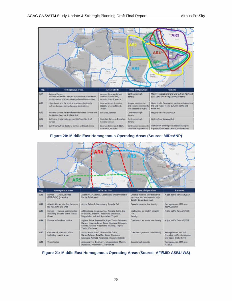
ACAC CNS/ATM Study Update & Strategic Planning Draft Final Report Airbus ProSky
75
Figure 20: Middle East Homogenous Operating Areas (Source: MIDeANP)
Figure 21: Middle East Homogenous Operating Areas (Source: AFI/MID ASBU WS)

ACAC CNS/ATM Study Update & Strategic Planning Draft Final Report Airbus ProSky
76
Traffic Flow Management capabilities and services are not being fully realised and are
accomplished on a tactical basis rather than pre-tactical/strategic, as depicted in Figure
22.
Figure 22: AFTM Capability usage (Source: Surveys, ICAO 2014)
6.5 Safety
For the purposes of studies such as this one, safety in nominally referred within the aviation
domain as aspects affecting or related to service provision, equipment, procedures, practices,
error/accident rates, trend analysis, licensing, airworthiness and other oversight areas. However,
for this study, there is another safety constraining factor that affects several of the ACAC
jurisdictional FIRs. This factor is the airspace safety Risk Classification for civil flights which is
based on two scenarios (1) risk of shoot down, inadvertent or intentional, and (2) an aircraft
emergency requiring a landing.
Each of these conditions is addressed in this section indicating the current status of safety from
these two perspectives.
6.5.1 Aviation Safety [2], [4]
Aviation and flight safety are fundamental working principles within the ACAC FIR ANSPs,
flight operators and groups and sub-groups that constitute the ACAC jurisdictional airspace. The
region has accepted and is working towards safety improvements by pursuing the following
coordinated activities:
Policy and Standardisation initiatives.
Monitoring of key safety trends and indicators.

ACAC CNS/ATM Study Update & Strategic Planning Draft Final Report Airbus ProSky
77
Safety Analysis.
Implementing programmes to address safety issues.
The effectiveness of the questionnaire supplied safety data required additional external resources
to be able to make a qualified regional safety assessment. This external data was obtained from
various ICAO safety reports and statistics and is the primary basis for this section.
The ACAC jurisdictional FIRs are aggregated among three ICAO statistical groupings, referred
to as: Regional Aviation Safety Group Regions (RASG-EUR, RASG-MID, and RASG-AFI) and
are depicted in Figure 23
Figure 23: ACAC State Distribution among ICAO RASG Regions
Within the RASGs the Universal Safety Oversight Audit Program (USOAP) measures the
effective implementation of protocols that cover the entire spectrum of a State’s civil aviation
oversight activities. Using established data collection, monitoring, and implementation
procedures the USOAP is able to determine a State’s capability to provide effective safety
oversight. The global average (62%) is used as an identification benchmark indicating an
effective safety implementation capability. Figure 24 illustrates those ACAC States above and
below the global average [2].

ACAC CNS/ATM Study Update & Strategic Planning Draft Final Report Airbus ProSky
78
Figure 24: ACAC State Distribution Relative to Global Safety Implementation Averages
A further analysis depicts a safety parameter, as portrayed in regional accident statistics of
commercial air transport within each RASG region. Table 14 and Table 15 depict the RASG
accident rates of commercial aircraft per million departures, and respectively further indicates
the RASG’s share of traffic compared to its share of accidents.
Table 14: RASG Accident Rate
RASG
Est. Depts. (in millions)
Number of Accidents
Accident Rate (per million
depts.)
Fatal Accidents
Fatalities
2014 2015 2014 2015 2014 2015 2014 2015 2014 2015
AFI 0.7 0.7 0.7 6 12.9 8.6 1 1 33 118
APAC 8.6 10.2 8.6 18 2.2 1.8 1 3 49 449
EUR 7.9 8.9 7.9 26 2.7 2.9 2 1 71 298
MID 1.1 3.0 1.1 7 1.8 2.3 0 2 0 39
PA 13.8 9.9 13.8 41 2.8 4.1 5 0 20 0
WORLD 32.1 33 32.1 98 2.8 3.0 9 7 173 904
Table 15: RASG Traffic/Accident Comparison
RASG Share of traffic
Share of Accidents
2014 2015 2014 2015
AFI 2% 2% 10% 6%

ACAC CNS/ATM Study Update & Strategic Planning Draft Final Report Airbus ProSky
79
RASG Share of traffic
Share of Accidents
2014 2015 2014 2015
APAC 31% 31% 21% 18%
EUR 27% 27% 23% 27%
MID 9% 9% 3% 7%
PA 30% 30% 43% 42%
While it is worth noting that the AFI and PA RASG region’s accident distribution is
considerably higher relative to their traffic segments, the only ACAC Member State within the
AFI region is Mauritania, and thus the percentage ratio may not accurately reflect that State’s
operation.
Figure 25 depicts the percentage of accidents and related fatalities by RASG region.
Figure 25: Percentage of Accidents and Fatalities per RASG Region
6.5.2 Airspace Safety Risk Classification [3]
Significant numbers of ACAC Member State FIRs have been classified based upon assessment
of risk of flying over each country’s borders. Risk has been assessed based on two potential
scenarios; (1) risk of shoot down, inadvertent or intentional, and (2) aircraft emergency requiring
a landing within the classified FIR. Classifications have been group into three levels:
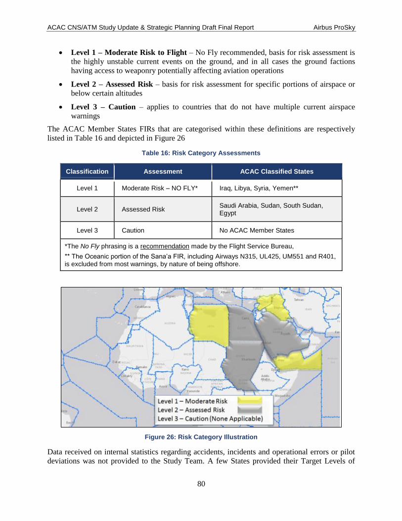
ACAC CNS/ATM Study Update & Strategic Planning Draft Final Report Airbus ProSky
80
Level 1 – Moderate Risk to Flight – No Fly recommended, basis for risk assessment is
the highly unstable current events on the ground, and in all cases the ground factions
having access to weaponry potentially affecting aviation operations
Level 2 – Assessed Risk – basis for risk assessment for specific portions of airspace or
below certain altitudes
Level 3 – Caution – applies to countries that do not have multiple current airspace
warnings
The ACAC Member States FIRs that are categorised within these definitions are respectively
listed in Table 16 and depicted in Figure 26
Table 16: Risk Category Assessments
Classification Assessment ACAC Classified States
Level 1 Moderate Risk – NO FLY* Iraq, Libya, Syria, Yemen**
Level 2 Assessed Risk Saudi Arabia, Sudan, South Sudan, Egypt
Level 3 Caution No ACAC Member States
*The No Fly phrasing is a recommendation made by the Flight Service Bureau,
**TheOceanicportionoftheSana’aFIR,includingAirways N315, UL425, UM551 and R401, is excluded from most warnings, by nature of being offshore.
Figure 26: Risk Category Illustration
Data received on internal statistics regarding accidents, incidents and operational errors or pilot
deviations was not provided to the Study Team. A few States provided their Target Levels of

ACAC CNS/ATM Study Update & Strategic Planning Draft Final Report Airbus ProSky
81
Safety. The data contained in this section was found in ICAO Safety Reports 2014 and 2015
Editions.
Recognised in the ICAO Safety Report 2015 is the United Arab Emirates (UAE) for significant
contributions in improving the coordination of accident and incident investigation activities in
the ACAC States. Holding workshops in 2012 and 2013 and attended by representatives from
Bahrain, Egypt, Jordan, Kuwait, Lebanon, Libya, Mauritania, Morocco, Oman, Saudi Arabia,
Tunisia, and UAE, led to the establishment of the Middle East and North Africa Society of Air
Safety Investigators (MENASASI), affiliated as a regional chapter of the International Society of
Air Safety Investigators (ISASI). The goal is to promote cooperation and to act proactively in
establishing cooperation in air accident investigation across the Middle East and ACAC States
[4].
The ACAC member States primarily fall into the MID Regional Aviation Safety Group with the
exception of Mauritania which falls into the AFI group

ACAC CNS/ATM Study Update & Strategic Planning Draft Final Report Airbus ProSky
82
7 FIR Categorisation
Each State in the study area was asked to provide current and forecasted operational traffic data.
These were collected and analysed to develop an operational overview of the current and
projected air traffic activity in the FIRs. Data included aggregate values that when analysed and
combined allowed the Study Team to create three categorisations of air traffic operations within
each FIR—High; Medium and Low. This methodology supports the concept of ‘one size does
not fit all’ and is similar to the philosophy of the ICAO Aviation System Block Upgrade
methodology.
These categorisations are a result of a combination of the number of operations in the ACC(s);
the density of operations in the ACC(s); the number of major aerodromes in the FIR; and the
total arrival and departure activity at the major aerodromes. These elements were evaluated for
the current activity (2013 data was supplied) and for years 2020, 2025 and 2030. In those cases
where data was not provided or was insufficient to draw conclusions, the project team attempted
to supplement and/or collect data from available public sources; however, only aerodrome data
from public sources was available. Similarly, if no data or insufficient future activity data was
provided, an increase factor of 7% was used to forecast activity for the out years. Definitions of
the traffic elements utilised follows:
Density of Operations – the amount of traffic that exists within the FIR airspace within a
one-year period. The values are based on total operations compared to the square nautical
mileage of the FIR.
Area Control Centre Facility Activity – activity within a one-year period in the En-
route environment as reported in the surveys.
Major Aerodromes – for the purposes of this study a major aerodrome is one with more
than thirty thousand total operations per year.
Aerodrome Activity – activity within a one-year period for major airports as reported in
the surveys and on public web sites if not reported by the State.
For the purposes of this study the Study Team defines a High-, Medium-, and Low-Activity FIR
as follows, and depicted in Table 17:
High-Activity FIR – an FIR that reported more than five hundred thousand but less than
one million total ACC operations and/or contains at least one aerodrome with greater
than one hundred and eighty thousand total operations.
Medium-Activity FIR – an FIR that reported more than two hundred thousand but less
than five hundred thousand total ACC operations and/or contains at least one aerodrome
that reported a range of eighty thousand to one hundred and eighty thousand operations.
Low-Activity FIR – an FIR that reported greater than fifty thousand but less than two
hundred thousand total ACC operations and/or contains at least one aerodrome that
reported a range of thirty thousand operations to eighty thousand operations.
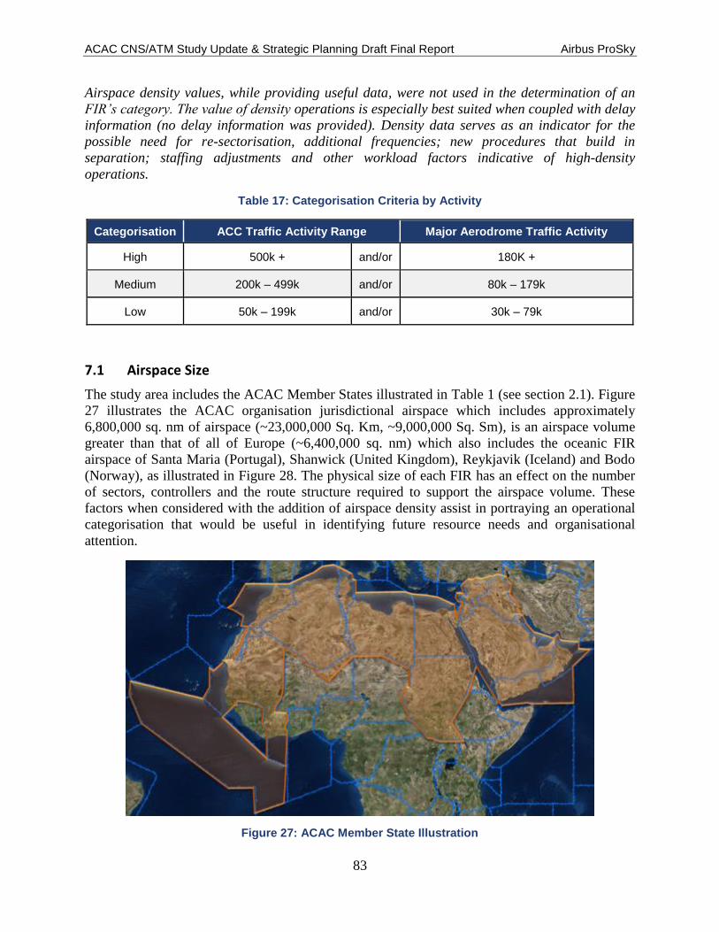
ACAC CNS/ATM Study Update & Strategic Planning Draft Final Report Airbus ProSky
83
Airspace density values, while providing useful data, were not used in the determination of an
FIR’s category. The value of density operations is especially best suited when coupled with delay
information (no delay information was provided). Density data serves as an indicator for the
possible need for re-sectorisation, additional frequencies; new procedures that build in
separation; staffing adjustments and other workload factors indicative of high-density
operations.
Table 17: Categorisation Criteria by Activity
Categorisation ACC Traffic Activity Range Major Aerodrome Traffic Activity
High 500k + and/or 180K +
Medium 200k – 499k and/or 80k – 179k
Low 50k – 199k and/or 30k – 79k
7.1 Airspace Size
The study area includes the ACAC Member States illustrated in Table 1 (see section 2.1). Figure
27 illustrates the ACAC organisation jurisdictional airspace which includes approximately
6,800,000 sq. nm of airspace (~23,000,000 Sq. Km, ~9,000,000 Sq. Sm), is an airspace volume
greater than that of all of Europe (~6,400,000 sq. nm) which also includes the oceanic FIR
airspace of Santa Maria (Portugal), Shanwick (United Kingdom), Reykjavik (Iceland) and Bodo
(Norway), as illustrated in Figure 28. The physical size of each FIR has an effect on the number
of sectors, controllers and the route structure required to support the airspace volume. These
factors when considered with the addition of airspace density assist in portraying an operational
categorisation that would be useful in identifying future resource needs and organisational
attention.
Figure 27: ACAC Member State Illustration
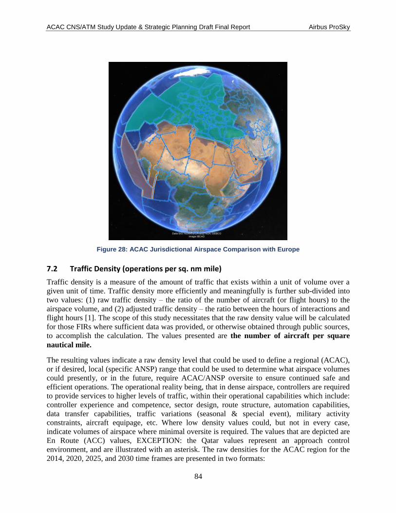
ACAC CNS/ATM Study Update & Strategic Planning Draft Final Report Airbus ProSky
84
Figure 28: ACAC Jurisdictional Airspace Comparison with Europe
7.2 Traffic Density (operations per sq. nm mile)
Traffic density is a measure of the amount of traffic that exists within a unit of volume over a
given unit of time. Traffic density more efficiently and meaningfully is further sub-divided into
two values: (1) raw traffic density – the ratio of the number of aircraft (or flight hours) to the
airspace volume, and (2) adjusted traffic density – the ratio between the hours of interactions and
flight hours [1]. The scope of this study necessitates that the raw density value will be calculated
for those FIRs where sufficient data was provided, or otherwise obtained through public sources,
to accomplish the calculation. The values presented are the number of aircraft per square
nautical mile.
The resulting values indicate a raw density level that could be used to define a regional (ACAC),
or if desired, local (specific ANSP) range that could be used to determine what airspace volumes
could presently, or in the future, require ACAC/ANSP oversite to ensure continued safe and
efficient operations. The operational reality being, that in dense airspace, controllers are required
to provide services to higher levels of traffic, within their operational capabilities which include:
controller experience and competence, sector design, route structure, automation capabilities,
data transfer capabilities, traffic variations (seasonal & special event), military activity
constraints, aircraft equipage, etc. Where low density values could, but not in every case,
indicate volumes of airspace where minimal oversite is required. The values that are depicted are
En Route (ACC) values, EXCEPTION: the Qatar values represent an approach control
environment, and are illustrated with an asterisk. The raw densities for the ACAC region for the
2014, 2020, 2025, and 2030 time frames are presented in two formats:

ACAC CNS/ATM Study Update & Strategic Planning Draft Final Report Airbus ProSky
85
1. Figure 29 illustrates the range of raw density values in line graph format. The values indicate
the number of aircraft operations per sq. nm.
Figure 29: Illustration of Raw ACAC Jurisdictional Airspace Density Value Ranges 2015–2030
2. Table 18 depicts the supporting density values in table format along with the associated
traffic levels and approximate FIR airspace volume in square nautical miles. (Note: traffic
values for the KSA and Egypt beyond the ANSP-provided base year have been extrapolated
into 2020, 2025, and 2030 using a 7.5% annual traffic projection increase).
Table 18: Data Supporting Raw Density Values
ACAC Regional En Route Traffic and Airspace Density Projections
FIR (ACC) FIR Sq.
nm 2014
Activity 2014
Density 2020
Activity 2020
Density 2025
Activity 2025
Density 2030
Activity 2030
Density
Algeria 728,983 156,400 0.21 209,600 0.29 267,400 0.37 341,300 0.47
Bahrain 22,973 573,400 24.96 815,000 35.48 1,088,000 47.36 1,400,000 60.94
Egypt 384,374 569,300 1.48 817,353 2.13 1,173,415 3.05 1,684,589 4.38
Oman 171,490 395,500 2.31 629,200 3.67 835,100 4.87 1,124,500 6.56
Qatar* 8,760 226,400^ 25.16 360,000 41.10 468,000 53.42 608,400 69.45
Saudi Arabia
618,218 643,157 1.04 923,335 1.49 1,325,567 2.14 1,903,023 3.08
Sudan 732,093 53,300 0.07 61,000 0.08 76,000 0.10 81,000 0.11
Tunisia 70,409 132,300^ 1.88 120,000 1.70 150,000 2.13 185,000 2.63
UAE 36,706 873,000 23.78 1,205,800 32.85 1,532,470 41.75 2,185,810 59.55
Lebanon 6279 65,514 10.43

ACAC CNS/ATM Study Update & Strategic Planning Draft Final Report Airbus ProSky
86
ACAC Regional En Route Traffic and Airspace Density Projections
FIR (ACC) FIR Sq.
nm 2014
Activity 2014
Density 2020
Activity 2020
Density 2025
Activity 2025
Density 2030
Activity 2030
Density
^ Data activities for years 2020 and beyond were extrapolated at a rate of 7% per year *Denotes Approach Control Airspace (Qatar)
Iraq** 127,231
Jordan** 27,785
Kuwait** 10,389
Libya** 579,196
Mauritania
Domestic** 867,501
Mauritania
Oceanic**
1,455,403
Morocco** 236,869
Palestine**
Syria** 55,663
Yemen** 348,180
**Data was not available to calculate the raw density values for the above listed FIRs
7.3 Major Aerodrome Activities
An accounting of aerodrome activity indicated that the number of ACAC member States
aerodromes is in excess of 200. To be able to determine a measurable level of operational
impact, the team reviewed the airport activities for each of these airports. An educated judgment
was made that those aerodromes that did not have an activity level of at least 10,000 (10k)
operations per year (primarily based on 2014 data) would not be included in the ACAC FIR
categorisation criteria. Those airports that exceed the 10k minimum activity level, where then
sub-divided into the following four activity classifications: >180k, >80k, >30k and >10k.
Table 19 depicts the (1) numbers of aerodromes within each FIR that meets the classification
criteria, and (2) the two highest specific aerodromes with their respective traffic activity.
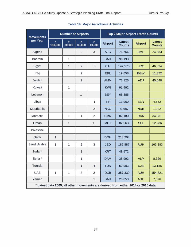
ACAC CNS/ATM Study Update & Strategic Planning Draft Final Report Airbus ProSky
87
Table 19: Major Aerodrome Activities
Movements per Year
Number of Airports Top 2 Major Airport Traffic Counts
> 180,000
> 80,000
> 30,000
> 10,000
Airport Latest Counts
Airport Latest Counts
Algeria
2 3 ALG 76,764 HME 24,383
Bahrain
1
BAH 96,193
Egypt
1 2 3 CAI 142,576 HRG 46,334
Iraq
2 EBL 19,658 BGW 11,372
Jordan
2 AMM 73,125 ADJ 45,048
Kuwait
1
KWI 91,992
Lebanon 1 BEY 68,885
Libya
1 TIP 13,960 BEN 4,552
Mauritania
2 NKC 4,686 NDB 1,982
Morocco 1 1 2 CMN 82,180 RAK 34,881
Oman 1 1 MCT 82,563 SLL 12,286
Palestine
Qatar 1
DOH 218,204
Saudi Arabia 1 1 2 3 JED 182,887 RUH 163,383
Sudan*
1 KRT 48,972
Syria *
1 DAM 38,992 ALP 8,320
Tunisia
1 4 TUN 52,903 DJE 13,156
UAE 1 1 3 2 DXB 357,339 AUH 154,821
Yemen
1 SAH 20,853 ADE 7,076
* Latest data 2009, all other movements are derived from either 2014 or 2015 data

ACAC CNS/ATM Study Update & Strategic Planning Draft Final Report Airbus ProSky
88
7.4 FIR Categorisation Determinations
Utilizing the criteria listed above, Table 20 depicts the resulting ACAC FIR categorisations.
Table 20: FIR Categorisations
FIR Categorisation FIR Categorisation
Bahrain High Tunisia Low
Egypt High Iraq Low
Qatar* High Jordan Low
Saudi Arabia High Lebanon Low
UAE High Mauritania
Domestic Low
Algeria Medium Mauritania
Oceanic
Oman Medium Syria Low
Kuwait Medium Sudan Low
Morocco Medium Libya Unable To Determine
*Denotes Approach Control Airspace (Qatar)
Palestine Unable To Determine
Yemen Unable To Determine
Table 21 depicts the aggregation of the elements used to establish the FIR categories used in this
study as well as the density of operations calculated for each FIR based on the FIR’s area and
ACC activity.
Table 21: Aggregated Data Elements
ACAC FIR Categorisations (Current)
FIR FIR Sq. nm 2014
Activity (ACC)
2014 Density
(ACC)
2015 Major Aerodrome Activity (1,000s) FIR
Categorisation >180 >80 >30
Bahrain 22,973 573,400 24.96 1 High
Egypt 384,374 569,300 1.48 1 2 High
Qatar* 8,760 220,400 25.16 1 High
Saudi Arabia 618,218 643,157 0.95 1 1 2 High

ACAC CNS/ATM Study Update & Strategic Planning Draft Final Report Airbus ProSky
89
ACAC FIR Categorisations (Current)
FIR FIR Sq. nm 2014
Activity (ACC)
2014 Density
(ACC)
2015 Major Aerodrome Activity (1,000s) FIR
Categorisation >180 >80 >30
UAE 36,706 873,000 23.78 1 1 3 High
Algeria 728,983 156,400 0.21 2 Medium**
Oman 171,490 395,500 2.31 1 Medium
Kuwait 10,389 0.00 1 Medium
Morocco 236,869 0.00 1 1 Medium
Tunisia 70,409 132,300 1.88 1 Low
Iraq 127,231 0.00 2 Low
Jordan 27,785 0.00 2 Low
Lebanon 6,279 65,514 10.43 1 Low
Mauritania
Domestic 867,501 0.00 2
Low
Mauritania
Oceanic 1,455,403 0.00 N/A N/A N/A
Syria 55,663 0.00 1 Low
Sudan 732,093 53,300 0.07 1 Low
Libya 579,196 0.00 No Data
Palestine No Data
Yemen 348,180 0.00 No Data
*Denotes Approach Control Airspace (Qatar)
**Major airport traffic activity was within in 1% of minimum Medium Categorisation definition
.

ACAC CNS/ATM Study Update & Strategic Planning Draft Final Report Airbus ProSky
90
8 Gap Analysis
This section will describe the methodology and baseline requirements, Regional/State planning
and ATC subject matter expertise to which the current operational capabilities are assessed to
determine the existence of any gaps.
8.1 Methodology
The Airbus ProSky Team evaluated gaps in capabilities to meet forecasted activity demand and
expected ABSU functionality, as illustrated in Figure 30.
Figure 30: Growth Accommodation
Gaps/Findings in the CNS-ATM in the Region are a compilation of the State’s objectives and
status in ICAO Global Air Navigation Plan and ICAO’s Block Upgrade methodology; the survey
data provided by the States as it pertains to the adequacy of elements of their communication,
navigation, surveillance capabilities and the research team’s understanding and assumptions of
how those capabilities are currently being utilised.
Utilizing data provided by States in the surveys, we analysed the progress made towards
reaching the objectives in the GANP ASBU plan in the following performance areas: Airport
operations; globally interoperable systems and data; optimum capacity and flexible flights and

ACAC CNS/ATM Study Update & Strategic Planning Draft Final Report Airbus ProSky
91
efficient flight paths. The ACAC block data is presented in a format that shows the ACAC status
of each module in each of four (4) Performance Improvement Areas (PIAs) within each of the
ASBU blocks, as illustrated below in Figure 31.
Figure 31: ACAC ASBU Comparison Format
The ASBU methodology includes 4 performance improvement areas:
PIA 1 - Airport Operations
PIA 2 - Globally-interoperable Systems and Data
PIA 3 - Optimum Capacity and Flexible Flights
PIA 4 - Efficient Flight Paths
Within each PIA contains the following modules:
PIA 1 - Modules include:
APTA – Optimisation of Approach Procedures including Vertical Guidance;
WAKE – Increased Runway Throughput through Optimised Wake Turbulence
Separation
SURF – Safety and Efficiency of Surface Operations
ACDM – Improved Airport Operations through Airport-CDM
RSEQ – Improved Traffic Flow through Sequencing
RATS – Remotely Operated Aerodrome Control
ACAC CNS/ATM Study Update & Strategic Planning Draft Final Report Airbus ProSky
92
PIA 2 - Modules include:
FICE – Increased Interoperability, Efficiency and Capacity through Ground to Ground
Integration
DATM – Service Improvement through Digital Aeronautical Information Management
SWIM – Performance Improvement through the Application of System-Wide
Information Management
AMET – Meteorological Information Supporting Enhanced Operational Efficiency and
Safety
PIA 3 - Modules include:
FRTO – Improved Operations through Enhanced En-route Trajectories
NOPS – Improved Flow Performance through Planning based on a Network-wide view
ASUR – Initial Capability for Ground Surveillance
ASEP – Air Traffic Situational Awareness
OPFL – Improved Access to Optimum Flight Levels through Climb/Descent Procedures
using ADS B
ACAS – Airborne Collision Avoidance System Improvements
SNET – Increased Effectiveness of Ground-Based Safety Nets
PIA 4 - Modules include:
CDO – Improved Flexibility and Efficiency in Descent Profiles using Continuous
Descent Operations
TBO – Improved Safety and Efficiency through the Initial Application of Data Link En-
route
CCO – Improved Flexibility and Efficiency Departure Profiles – Continuous Climb
Operations
RPAS – Initial Integration of Remotely Piloted Aircraft into Non-segregated Airspace
The block upgrade modules are aimed at achieving a fully-harmonised global air navigation
system. The Block Upgrade methodology allows each State to consider and adopt the modules
appropriate for their operational needs. In this report we have followed the same methodology by
assigning each State studied a categorisation of High, Medium or Low based on its current
operational activity in the en-route environment; the density of operations based on total
operations compared to the square mileage of the FIR and the activity at the major aerodromes.
This methodology supports the concept that “one size doesn’t fit all”. The gaps discerned in the
high-density environments will ultimately have a greater impact on the efficiency of the entire
region.

ACAC CNS/ATM Study Update & Strategic Planning Draft Final Report Airbus ProSky
93
Likewise gaps discerned in the low-density environments will have less impact on the region.
Regardless of the current volume of operations in any individual FIR there are best practices that
all should strive to achieve in order to be prepared for the future. These are also included in this
report.
Although the findings are regional, as recommendations they have more application in some
specific areas than others. This will be described in section 10 Recommendations.
8.2 Gaps
Gaps are presented in this report in two ways. First by comparing the ICAO ASBU methodology
to the States current status in meeting the targets in the performance areas and second in an
itemised list of the Study Team’s observations in the areas of:
ANSP Interoperability
Airspace Policy/Procedures
Separation Standards
Routing
Contingency and Growth Planning
Civil-Military
Airport Policy/Procedures
Airport Physical Infrastructure
Traffic Flow Management/Collaborative Decision Making
8.2.1 Status of ASBU Block 0 and Block 1 for Performance Improvement Areas 1-4:
Table 22 to Table 29 describe the ASBU four performance improvement areas modules for
Blocks 0 through 3 and the current status and/or targets the studied States reported in the
surveys. Block 0 is comprised of technologies and capabilities in existence today. The Modules
are characterised by operational improvements that have already been implemented in many
parts of the world. These are near term elements with an implementation period of 2013 through
2018. Block 1 Modules introduce new concepts and capabilities that support the future ATM
system. The Block 1 Modules are intended to be available in the 2018 timeframe. Consecutive
Blocks (2 and 3) follow the same module’s thread in the performance area with targets in the
2023 through 2028 and onward timeframe.
Table 22, Table 23, Table 24, and Table 25 present the status of ASBU Block 0 and Block 1 for
Performance Improvement Areas 1–4.

ACAC CNS/ATM Study Update & Strategic Planning Draft Final Report Airbus ProSky
94
Table 22: PIA 1 – ASBU 0, 1
Performance Improvement Area 1: Airport Operations
ASBU Block 0 ASBU Block 1 ACAC Status
AP
TA
Optimisation of Approach Procedures including Vertical Guidance •PBNandGLSproceduresenhance the reliability and predictability of approaches to runways •Usesglobalnavigationsatellite system (GNSS), Baro-vertical navigation (VNAV), satellite-based augmentation system (SBAS)
Optimised Airport Accessibility
• Universal implementation of Performance-based Navigation (PBN) approaches •PBNandGLS(CATII/III)procedures
APTA Block-0/1 applies to all areas.
Progress towards implementation of the APTA Block-0 module ranges from 20% to 80% among the high traffic density FIRs.
Medium- and low-density FIRs range from 100% implementation to approx. 40%. No implementation of APTA-Block 1
WA
KE
Increased Runway Throughput through Optimised Wake Turbulence Separation •RevisionofcurrentICAOwake vortex separation minima and procedures •Improvesthroughputondeparture and arrival runways through optimised wake turbulence separation minima
Increased Runway Throughput through Dynamic Wake Turbulence Separation •Dynamicmanagementofwake turbulence separation minima •Basedonthereal-time identification of wake turbulence hazards
WAKE Block-0/1 applies to all areas.
The WAKE Block0/1 modules have not been implemented within the FIRs assessed.
RS
EQ
Improved Traffic Flow through Sequencing (AMAN/DMAN)
•Managearrivalsanddepartures (including time-based metering) to efficiently utilise the inherent runway capacity •Usedatmulti-runway aerodrome or multiple dependent runways at closely proximate aerodromes
Improved Airport Operations through Departure, Surface and Arrival Management
•Extensionofarrivalmetering •Integrationofsurfacemanagement with departure sequencing
RSEQ Block-0/1 applies to high density areas.
The RSEQ Block-0 module has not been implemented within the FIRs assessed with the exception of one Medium-density FIR where partial implementation has been accomplished.
No implementation of RSEQ Block-1.

ACAC CNS/ATM Study Update & Strategic Planning Draft Final Report Airbus ProSky
95
Performance Improvement Area 1: Airport Operations
ASBU Block 0 ASBU Block 1 ACAC Status
SU
RF
Safety and Efficiency of Surface Operations (A-SMGCS Level 1-2) •Providesurveillanceandalerting of aircraft and vehicle movement at the aerodrome •UsesbasicA-SMGCS and ADS-B
Enhanced Safety and Efficiency of Surface Operations – SURF, SURF-IA and Enhanced Vision Systems (EVS)
•Enhancementsforsurfacesituational awareness including both cockpit and ground elements •Useofsurfacemovingmapswith traffic information and runway safety alerting logic
SURF Block-0/1 applies to all areas. The majority of the - activity FIRs have full implementation of the SURF Block-0 module. One will accomplish partial implementation by the end of the year.
The Moderate-activity FIRs have achieved partial implementation currently or by the end of next year.
No implementation reported within the Low-activity FIRs.
No implementation of SURF-Block-1
A-C
DM
Improved Airport Operations through Airport-CDM •Collaborativeapplications allow sharing of surface operations data among the different stakeholders on the airport •Improvesurfacetrafficmanagement reducing delays on movement and manoeuvrings areas
Optimised Airport Operations through A-CDM Total Airport Management •Enhancestheplanningandmanagement of Airport Operations using performance targets compliant with those of the surrounding airspace •Implementcollaborativeairport operations planning (AOP) and where needed, an airport operations centre (APOC)
A-CDM Blocks 0/1 apply to all areas.
There has been no implementation of the A-CDM Block-0/1 modules. The High-activity and one Medium-activity FIRs have developed implementation plans and expect to be operational in the 2017-18 time-frames.
RA
TS
NA
Remotely Operated Aerodrome Control •Providesasafeandcost-effective air traffic services (ATS) from a remote facility •Foraerodromeswherededicated, local ATS are no longer sustainable or cost-effective
RATS Block-1 applies to all areas.
No implementation of RATS Block-1
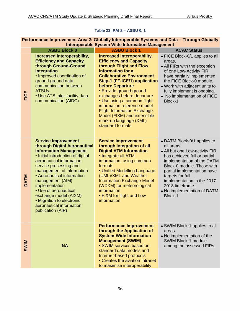
ACAC CNS/ATM Study Update & Strategic Planning Draft Final Report Airbus ProSky
96
Table 23: PAI 2 – ASBU 0, 1
Performance Improvement Area 2: Globally Interoperable Systems and Data – Through Globally Interoperable System Wide Information Management
ASBU Block 0 ASBU Block 1 ACAC Status
FIC
E
Increased Interoperability, Efficiency and Capacity through Ground-Ground Integration
•Improvedcoordinationofground-ground data communication between ATSUs. •UseATSinter-facility data communication (AIDC)
Increased Interoperability, Efficiency and Capacity through Flight and Flow Information for a Collaborative Environment Step-1 (FF-ICE/1) application before Departure
•Provideground-ground exchanges before departure •Useusingacommonflightinformation reference model Flight Information Exchange Model (FIXM) and extensible mark-up language (XML) standard formats
FICE Block-0/1 applies to all areas.
All FIRs with the exception of one Low-Activity FIR, have partially implemented the FICE Block-0 module.
Work with adjacent units to fully implement is ongoing.
No implementation of FICE Block-1
DA
TM
Service Improvement through Digital Aeronautical Information Management •Initialintroductionofdigitalaeronautical information service processing and management of information •Aeronauticalinformationmanagement (AIM) implementation •Useofaeronauticalexchange model (AIXM) •Migrationtoelectronicaeronautical information publication (AIP)
Service Improvement through Integration of all Digital ATM Information
• Integrate all ATM information, using common formats •Unified Modelling Language (UML)/XML and Weather Information Exchange Model (WXXM) for meteorological information •FIXMforflightandflowinformation
DATM Block-0/1 applies to all areas
All but one Low-activity FIR has achieved full or partial implementation of the DATM Block-0 module. Those with partial implementation have targets for full implementation in the 2017-2018 timeframe.
No implementation of DATM Block-1.
SW
IM
NA
Performance Improvement through the Application of System-Wide Information Management (SWIM)
•SWIMservicesbasedonstandard data models and Internet-based protocols •CreatestheaviationIntranetto maximise interoperability
SWIM Block-1 applies to all areas.
No implementation of the SWIM Block-1 module among the assessed FIRs.

ACAC CNS/ATM Study Update & Strategic Planning Draft Final Report Airbus ProSky
97
Performance Improvement Area 2: Globally Interoperable Systems and Data – Through Globally Interoperable System Wide Information Management
ASBU Block 0 ASBU Block 1 ACAC Status
AM
ET
Meteorological Information Supporting Enhanced Operational Efficiency and Safety
•WeatherInformation Exchange •Forecastsprovidedbyworldarea forecast centres •Conciseinformation of meteorological conditions that could adversely affect all aircraft at an aerodrome •SIGMETstoprovideinformation on occurrence or expected occurrence of specific en-route weather phenomena
Enhanced Operational Decisions through Integrated Meteorological Information (Planning and Near-term Service)
•FullATM-Meteorology integration Meteorological information is included in the logic of a decision process •Impactofthemeteorologicalconditions (constraints) are automatically calculated and taken into account •Promotestheestablishmentof Standards for global exchange of the information
AMET Blocks-0/1 applies to all areas.
Full implementation of the AMET Block-0 module among the High-activity FIRs.
Partial or no implementation among the remaining FIRs.
No implementation of AMET Block-1.
Table 24: PIA 3 – ASBU 0, 1
Performance Improvement Area 3: Optimum Capacity and Flexible Flights
ASBU Block 0 ASBU Block 1 Status
FR
TO
Improved Operations through Enhanced En-route Trajectories
•Allowtheuseofairspacewhich would otherwise be segregated (i.e., Special Use Airspace [SUA]) •Allowsflexibleroutingadjusted for specific traffic patterns
Improved Operations through Optimised ATS Routing
•Providescloserandconsistent route spacing, curved approaches, parallel offsets and the reduction of holding area size. Through Performance-based Navigation (PBN) •Allowsthesectorisation of airspace to be adjusted more dynamically
FRTO Block-0/1 applies to all areas.
One - activity FIR has completed FRTO Block-0.
The remaining High-activity FIRs have begun development of procedures and creating agreements for FUA.
The Medium- and Low-activity FIRs report little or no progress towards implementation.
No implementation of FRTO Block -1

ACAC CNS/ATM Study Update & Strategic Planning Draft Final Report Airbus ProSky
98
Performance Improvement Area 3: Optimum Capacity and Flexible Flights
ASBU Block 0 ASBU Block 1 Status
NO
PS
Improved Flow Performance through Planning based on a Network-wide view •Airtrafficflowmanagement(ATFM) is used to manage the flow of traffic in a way that minimises delays and maximises the use of the entire airspace •Regulatepeakflowsinvolving departure slots •Managedrateofentryintoagiven piece of airspace, requested time at a waypoint or an FIR/sector boundary along the flight •Useofmiles-in-trail to smooth flows •Re-routing of traffic to avoid saturated areas
Enhanced Flow Performance through Network Operational Planning
•Enhancedprocessestomanage flows or groups of flights in order to improve overall flow
NOPS Block-0/1 applies to Medium- and High-activity areas.
Among the High-activity FIRs, one reports full implementation of the Block-0 module.
The remaining High-activity FIRs report they are in the progress of working or plan to work with adjacent units and users, and have implementation targets in the 2017-18 timeframe.
The remaining Medium- and Low-activity FIRs report a range from full to partial implementation. No implementation of NOPS Block-1.
AS
UR
Initial Capability for Ground Surveillance
•Providesinitialcapabilityforlower cost ground surveillance such as traffic information, search and rescue and separation provision •SupportedbyADS-B OUT and/or wide area multilateration (MLAT) systems
NA
ASUR Block 1 applies to Medium- and High-activity areas.
Among the High-activity FIRs ASUR is N/A at one. Among the remaining FIRs implementation ranges from none to full.
Note: This capability is characterised by being dependent/cooperative (ADS-B OUT) and independent/cooperative (MLAT).
The overall performance of ADS-B is affected by avionics performance and compliant equipage rate

ACAC CNS/ATM Study Update & Strategic Planning Draft Final Report Airbus ProSky
99
Performance Improvement Area 3: Optimum Capacity and Flexible Flights
ASBU Block 0 ASBU Block 1 Status
AS
EP
Air Traffic Situational Awareness (ATSA)
•ATSAapplicationswillenhance safety and efficiency •AIRB(EnhancedTrafficSituational Awareness during Flight Operations) •VSA(EnhancedVisualSeparation on Approach)
Increased Capacity and Efficiency through Interval Management •Improvestheorganisation of traffic flows and aircraft spacing •Precisemanagementofintervals between aircraft with common or merging trajectories
ASEP Block-0 applies to aircraft; ASEP Block-1 applies to Medium- and High-activity areas.
ASEP Block-0 is cockpit-based applications which can be used by any suitably equipped aircraft. This is dependent upon aircraft being equipped with ADS-B OUT.
No implementation of ASEP Block-1
OP
FL
Improved Access to Optimum Flight Levels through Climb/Descent Procedures using ADS B •InTrailClimb/DescentProcedures •Enablesaircrafttoreachamore satisfactory flight level for flight efficiency or to avoid turbulence for safety
NA
OPFL Block-0 applies to all areas
No implementation of OPFL module among the FIRs studied.
AC
AS
Airborne Collision Avoidance Systems (ACAS) Improvements
•Improvementstoexistingsystems •Reducetrajectorydeviationsand increase safety in cases where there is a breakdown of separation
NA
ACAS applicable to aircraft.
Provides short-term improvements to existing airborne collision avoidance systems (ACAS) to reduce nuisance alerts while maintaining existing levels of safety. This will reduce trajectory deviations and increase safety in cases where there is a breakdown of separation.

ACAC CNS/ATM Study Update & Strategic Planning Draft Final Report Airbus ProSky
100
Performance Improvement Area 3: Optimum Capacity and Flexible Flights
ASBU Block 0 ASBU Block 1 Status
SN
ET
Increased Effectiveness of Ground-based Safety Nets •Monitorstheoperationalenvironment during airborne phases of flight •Providestimelyalertsonthe ground of an increased risk to flight safety
Ground-based Safety Nets on Approach
•Reducestheriskofcontrolled flight into terrain accidents on final approach through the use of an approach path monitor (APM)
SNET Block-0 applies to all areas.
SNET Block-1 applies to medium- and high-density areas.
SNET Block-0 is implemented among all the High-activity FIRs except one.
Among the Medium- and Low-activity FIRs implementation ranges from full to partial.
No implementation of SNET Block-1.
Table 25: PIA 4 – ASBU 0, 1
Performance Improvement Area 4: Efficient Flight Paths
ASBU Block 0 ASBU Block 1 Status
CD
O
Improved Flexibility and Efficiency in Descent Profiles using Continuous Descent Operations (CDOs) •Performance-based airspace and arrival procedures Continuous Descent Operations •Allowsaircrafttoflytheiroptimum profile using continuous descent operations (CDOs)
Improved Flexibility and Efficiency in Descent Profiles (CDO)
•Enhancedverticalflight path precision during descent and arrival • Enables aircraft to fly an arrival procedure not reliant on ground-based equipment for vertical guidance
CDO Block-0/1 applies to all areas.
One-Low activity FIR reports full implementation of CDO Block-0.
The remaining FIRs have partial implementation and/or targets for full or partial implementation in the 2016-2018 time-frames.
No implementation of CDO Block-1.
TB
O
Improved Safety and Efficiency through the Initial Application of Data Link En-route
•Forsurveillanceandcommunications in air traffic control •Supportsflexiblerouting,reduced separation and improved safety
Improved Traffic Synchronisation and Initial Trajectory-based Operation (TBO) •Optimise the approach sequence through the use of 4DTRAD capability and airport applications, e.g., D-TAXI •Improvesthesynchronisation of traffic flows at en-route merging points
TBO Block-0 applies to all areas. TBO Block-1 applies to Medium and High-activity areas.
No implementation of TBO Block-0/1.
Requires good synchronisation of airborne and ground deployment to generate significant benefits, in particular to those equipped. Benefits increase with the proportion of equipped aircraft.

ACAC CNS/ATM Study Update & Strategic Planning Draft Final Report Airbus ProSky
101
Performance Improvement Area 4: Efficient Flight Paths
ASBU Block 0 ASBU Block 1 Status
CC
O
Improved Flexibility and Efficiency Departure Profiles – Continuous Climb Operations (CCO)
•Implementscontinuousclimboperations (CCO) in conjunction with Performance-based Navigation (PBN) •Providesopportunitiestooptimise throughput, improve flexibility, enable fuel-efficient climb profiles, and increase capacity at congested terminal areas
NA
CCO Block-0 applies to all areas
One-Low activity FIR reports implementation of CCO Block-0. The remaining FIRs have established targets with implementation in the 2016-2019 time frames.
RP
AS
NA
Initial Integration of Remotely Piloted Aircraft (RPA) into Non-segregated Airspace •Implementationofbasicprocedures for operating RPA in non-segregated airspace, including detect and avoid
RPAS Block-1 applies to all areas.
No implementation of RPAS Block-1

ACAC CNS/ATM Study Update & Strategic Planning Draft Final Report Airbus ProSky
102
8.2.2 Status of ASBU Block 2 and Block 3 for Performance Improvement Areas 1-4:
ASBU Blocks 2 and 3 follow the same module’s thread as in Block 0 and 1 in each of the four
Performance Improvement Areas with targets in the 2023 through 2028 and onward timeframe.
These are far term elements.
Table 26, Table 27, Table 28, and Table 29 describe the modules within the performance area
and to what level of activity FIR they apply. Throughout the FIRs that responded to the surveys
indicate no implementation of the Block 0 and 1 modules.
Table 26: PIA 1 – ASBU 2, 3
Performance Improvement Area 1: Airport Operations
ASBU Block 3 ACAC Status
WA
KE
Advanced Wake Turbulence Separation (Time-based)
•Applicationoftime-based aircraft-to-aircraft wake separation minima •Changestotheproceduresthe ANSP uses to apply wake separation minima
NA
WAKE Block-2 applies to all areas.
No implementation
RS
EQ
Linked Arrival Management and Departure Management (AMAN/DNAM) •IntegratedAMAN/DMANtoenable dynamic scheduling and runway configuration •Integratesarrivalanddeparture management •Betteraccommodationofarrival/departure patterns
Integration AMAN/DMAN/SMAN
• Integrated arrival, en-route, surface, and departure management
RSEQ Block-2/3 applies to High-activity areas.
No implementation
SU
RF
Optimised Surface Routing and Safety Benefits (A-SMGCS Level 3-4 and SVS) •Queuingfordeparturerunways is reduced to the minimum necessary to optimise runway use and taxi times are also reduced •Low-visibility conditions have only a minor effect on surface movement
NA
SURF Block-2 applies to High-activity areas.
No implementation
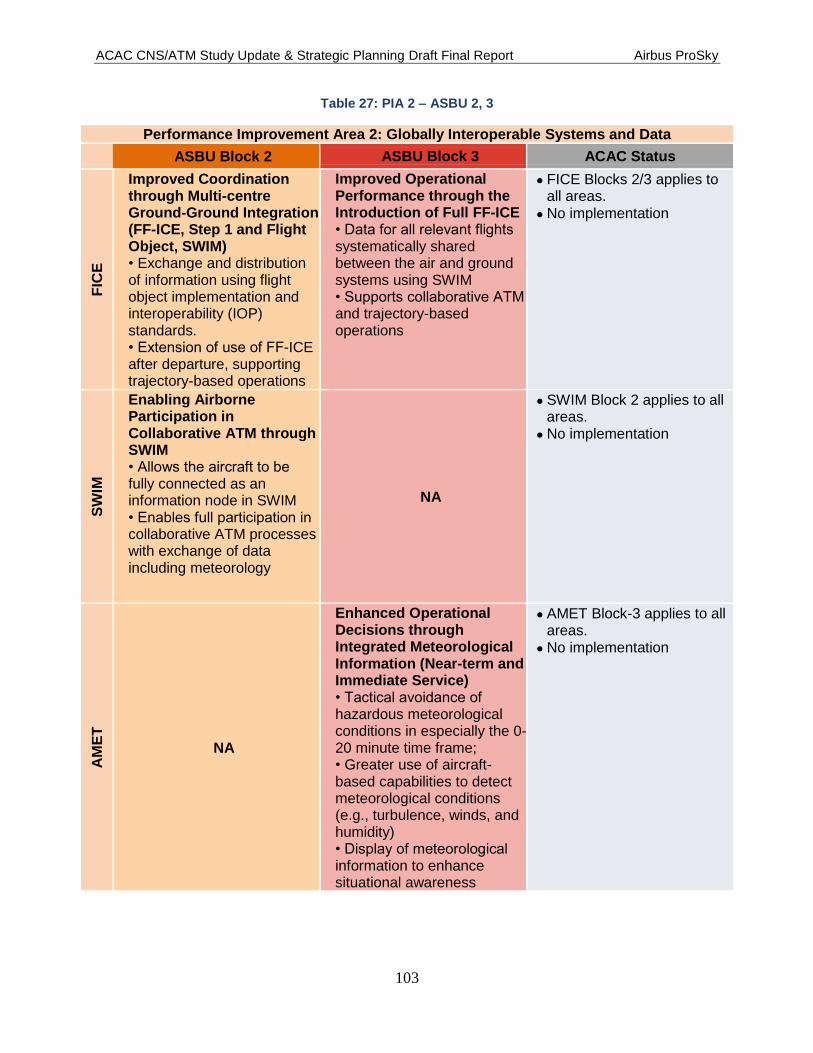
ACAC CNS/ATM Study Update & Strategic Planning Draft Final Report Airbus ProSky
103
Table 27: PIA 2 – ASBU 2, 3
Performance Improvement Area 2: Globally Interoperable Systems and Data
ASBU Block 2 ASBU Block 3 ACAC Status
FIC
E
Improved Coordination through Multi-centre Ground-Ground Integration (FF-ICE, Step 1 and Flight Object, SWIM)
• Exchange and distribution of information using flight object implementation and interoperability (IOP) standards. •ExtensionofuseofFF-ICE after departure, supporting trajectory-based operations
Improved Operational Performance through the Introduction of Full FF-ICE •Dataforallrelevantflightssystematically shared between the air and ground systems using SWIM •SupportscollaborativeATMand trajectory-based operations
FICE Blocks 2/3 applies to all areas.
No implementation
SW
IM
Enabling Airborne Participation in Collaborative ATM through SWIM
•Allowstheaircrafttobefully connected as an information node in SWIM •Enablesfullparticipationincollaborative ATM processes with exchange of data including meteorology
NA
SWIM Block 2 applies to all areas.
No implementation
AM
ET
NA
Enhanced Operational Decisions through Integrated Meteorological Information (Near-term and Immediate Service) •Tacticalavoidanceofhazardous meteorological conditions in especially the 0-20 minute time frame; • Greater use of aircraft-based capabilities to detect meteorological conditions (e.g., turbulence, winds, and humidity) •Displayofmeteorologicalinformation to enhance situational awareness
AMET Block-3 applies to all areas.
No implementation

ACAC CNS/ATM Study Update & Strategic Planning Draft Final Report Airbus ProSky
104
Table 28: PIA 3 – ASBU 2, 3
Performance Improvement Area 3: Optimum Capacity and Flexible Flights
ASBU Block 2 ASBU Block 3 ACAC Status
NO
PS
Increased User Involvement in the Dynamic Utilisation of the Network • CDM applications
supported by SWIM that permit airspace users to manage competition and prioritisation within ATFM constraint mitigation solutions • CDM applications by which ATM will be able to offer/delegate to the users the optimisation of solutions to flow problems
Traffic Complexity Management • Complexity management to address events and phenomena that affect traffic flows, including physical limitations and economic reasons •Exploitsthemoreaccurateand rich information environment of SWIM-based ATM
NOPS Block 2 applies to all areas.
No implementation.
NOPS Block 3 applies to High-activity areas.
No implementation
AS
EP
Airborne Separation (ASEP) • Temporary delegation of
responsibility to the flight deck for separation provision with suitably equipped designated aircraft, thus reducing the need for conflict resolution clearances •Controllerretainsresponsibility for separation from aircraft that are not part of these clearances.
NA
ASEP applies to Medium- to High-activity areas
No implementation
AC
AS
New Collision Avoidance System • Implementation of the
airborne collision avoidance system (ACAS) adapted to trajectory-based operations with improved surveillance function supported by ADS-B •Adaptivecollisionavoidance logic aiming at reducing nuisance alerts and minimizing deviations
NA
ACAS Block-2 applies to Aircraft Only

ACAC CNS/ATM Study Update & Strategic Planning Draft Final Report Airbus ProSky
105
Table 29: PIA 4 – ASBU 2, 3
Performance Improvement Area 4: Efficient Flight Paths
ASBU Block 2 ASBU Block 3 ACAC Status
CD
O
Improved Flexibility and Efficiency in Continuous Descent Profiles (CDOs) Using VNAV, Required Speed and Time at Arrival • Use of arrival procedures
that allow the aircraft to apply little or no throttle in areas where traffic levels would otherwise prohibit this operation •Considers airspace complexity, air traffic workload, and procedure design
NA
CDO Block 2 applies to High-activity areas.
No implementation
TB
O
NA
Full 4D Trajectory-based Operations • Advanced concepts and technologies supporting four dimensional trajectories to enhance global ATM decision-making •Integratesallflightinformation to obtain the most accurate trajectory model for ground automation
TBO Block-3 applies to all areas.
No implementation
RP
AS
Remotely Piloted Aircraft (RPA) Integration in Traffic • Continuing to improve the remotely piloted aircraft (RPA) access to non-segregated airspace •Continuingtoimprovetheremotely piloted aircraft system (RPAS) approval/certification process •Standardizingthecommandand control (C2) link failure procedures •Agreeingonauniquesquawk code for C2 link failure •Detectandavoidtechnologies, to include automatic dependent surveillance – broadcast (ADS-B)
Remotely Piloted Aircraft (RPA) Transparent Management •Improvethecertificationprocess for remotely piloted aircraft (RPA) in all classes of airspace •Developsareliablecommand and control (C2) link •Developingandcertifyingairborne detect and avoid (ABDAA) algorithms for collision avoidance • Integrates RPA into aerodrome procedures
RPAS Block 2/3 applies to all areas.
No Implementation

ACAC CNS/ATM Study Update & Strategic Planning Draft Final Report Airbus ProSky
106
9 Findings
9.1 Regional Findings
The following findings address the Study Teams findings in current capabilities and services.
Much of these findings were derived from the surveys provided by the individual States plus a
review of any internal documents that were submitted by the States. Unable to conduct direct
observation of the air traffic operations resident in the participating States, the research team
relied primarily on the responses to the questions in the surveys, ICAO documents, and the very
limited amount of internal documentation that was provided. Web searches for detailed air traffic
control policies and procedures, as well as working practices, were attempted but yielded little
result. Those States that provided candid responses to the survey allowed the team the best
opportunity to attempt to assess the picture of the current state of the day to day air traffic control
operation. The following findings apply to all assessed States based on their existing and forecast
traffic density. Where there is a tie either directly or indirectly to the Block Upgrade modules it
is indicated at the end of the statement. I.e., PIA – 3 refers to Performance Improvement Area 3:
Optimum Capacity and Flexible Flights – Through Global Collaborative ATM.
9.1.1 ANSP Interoperability
Various individual Air Navigation Service Providers (ANSPs) strategic planning efforts
are advancing with insufficient adjacent ANSP acceptance and integration.
A common framework for increasing the level of cooperation in conducting accident
investigations appears to be in development. There is no mention of a framework for
increasing communications and cooperation for conducting other safety analysis. (PIA-3)
AIP data is not uniformly available across all ACAC member States. (PIA-2)
Encourage standardisation of Air Traffic procedures wherever possible. (All PIAs)
CDM organisation and processes vary among the ACAC members, ranging from full and
effective participation to minimal participation. (PIA-3)
Insufficient procedures for the coordination of traffic conditions to prevent oversaturation
of operational sectors. (PIA-3)
Operational sectors become oversaturated, very often at predictable times and flows.
(PIA-3)
Individual operating and support systems are not fully interoperable nor share common
functionalities and flight data with adjacent FIRs. (PIA-2)
Current staffing levels at select facilities are inadequate for the required service
provision, as illustrated in Figure 32.
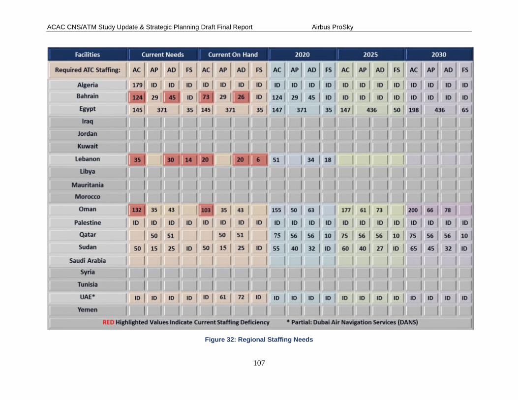
ACAC CNS/ATM Study Update & Strategic Planning Draft Final Report Airbus ProSky
107
Figure 32: Regional Staffing Needs

ACAC CNS/ATM Study Update & Strategic Planning Draft Final Report Airbus ProSky
108
9.1.2 Airspace Policy/Procedures
Airspace design among ANSPs while generally effective for local operations do not
always provide seamlessness with adjacent FIR airspace designs. (PIA-3,4)
Manual and verbal handoff procedures exist among many of the ACAC ANSP common
boundaries.
Existing and authorised ATC procedures are not being fully utilised to their fullest
advantage (e.g., visual separation, radar separation, automated flight data transfer).
(PIA 1-4)
Sector designs are often based on legacy aircraft capabilities, and thus have become
inefficient relative to modern aircraft capabilities and operator desires. (PIA-4)
PBN advancement is continuing more on a local basis than a regional basis, and often is
limited within a single FIR. (PIA-1)
Significant changes to homogenous area traffic flows are expected that will have
substantial effects on current airspace design and procedures as sequentially depicted in
Figure 33. An example of a significant change to a homogenous area in the Middle East
is illustrated in Figure 34.
Figure 33: Near-Far Term Homogenous Area Traffic Impacts

ACAC CNS/ATM Study Update & Strategic Planning Draft Final Report Airbus ProSky
109
Figure 34: AR4 Middle East Homogenous Area Expansion
9.1.3 Separation Standards
Inconsistent use of same separation standards among adjacent ANSPs, especially in the
en route environment. (PIA-3)
ATC conflict alert and monitoring features are not available in all ANSP operating
systems. (PIA-3)
There is little to no indication of application of visual separation between arrivals on
same runway, arrivals to parallel runways, and arrivals from departures. (Training)
Existing and authorised ATC procedures are not being fully utilised to their fullest
advantage (e.g., visual separation, parallel runway operations, and diverging departure
headings.). (Policy and Training)
There is no indication of the application of diverging departure heading separation
procedures for both same runway and parallel runways. (Policy and Training)
9.1.4 Routing
The development is not evident of additional routes offset from primary routes that would
allow a fast track/slow track capability.
The use of single direction routes could have a negative effect on the overall efficiency of
the airspace and controller resources, this is most noticed in the Gulf Region States

ACAC CNS/ATM Study Update & Strategic Planning Draft Final Report Airbus ProSky
110
Development and better use of flexible point-to-point routing for high-altitude operations,
except where structured routing is required would be operationally feasible in many
ANSPs. (PIA-3)
There is an immediate need to develop and/or enhance existing Flexible Use of Airspace
(FUA) procedures to provide allocation of airspace based on tactical needs within the
FIR. (PIA-3)
9.1.5 Contingency and Growth Planning
Several States have conducted detailed analysis of operational position needs within each
State through 2030, and are developing a plan to meet those needs with optimum
effectiveness and efficiency. Growth planning is critical for continued safe and efficient
operations; however, many States did not respond to this data request, and thus there is a
great amount of uncertainty as to whether the regional as a whole is prepared to
accommodate projected traffic growth. Figure 35 and Figure 36 respectively denote
regional ANSP ACC Sector and APC Sector forecasts through the near and far term
periods.
Figure 35: ACAC Regional ACC Forecast Near-Far Term

ACAC CNS/ATM Study Update & Strategic Planning Draft Final Report Airbus ProSky
111
Figure 36: ACAC Regional APC Forecast Near-Far Term
We were unable to determine if many facilities can ensure continuity of operations in the
event of a system failure. UAE in particular is fully capable to indefinitely sustain such
an event.
From the reporting ANSPs there are several significant facility expansion needs and
planning through 2020 as indicated in Figure 37.

ACAC CNS/ATM Study Update & Strategic Planning Draft Final Report Airbus ProSky
112
Figure 37: ACAC ANSP Facility Expansion Needs

ACAC CNS/ATM Study Update & Strategic Planning Draft Final Report Airbus ProSky
113
9.1.6 Civil-Military
Very little data was submitted regarding the development of high-level agreements and
plans that would result in transition to integrated civil-military airspace management.
(PIA 1-4)
Very little data was submitted regarding enhancing Flexible Use of Airspace procedures
to provide allocation of airspace based on tactical needs. (PIA-3)
There does not appear to be Region wide Enterprise Architecture for the provision of air
navigation services and information, including military. Establish processes to ensure
common standards and requirements for air navigation service provision within each FIR.
(PIA 1-4)
9.1.7 Airport Policy/Procedures
There are several major airports that do not, appear to routinely use mixed-use runway
procedures when there are peaks periods with higher numbers of arrivals or departures.
(PIA 1,3)
Planning for operational improvements can be enhanced by conducting a review of
airport procedures and master plans to ensure they support minimizing operations on
runways for other than actual take-offs and landings.
Increase Airport throughput and capacity can be increased through application of global
best practice procedures. (PIA-1)
9.1.8 Airport Physical Infrastructure
Airport planning projects’ information was insufficient to reach a meaningful finding or
identify a gap; however, actions should be taken to ensure that any such actions are
coordinated with all stakeholders to ensure capacity and efficiency impacts are
understood and mitigated to the maximum extent possible. (PIA-1)
Based on current and forecasted airport demand, it is unsure from the data received that
any accelerated planning and construction for rapid exit taxiways to be optimally located
to minimise runway occupancy time for typical aircraft is underway. (PIA-1)
9.1.9 TFM/CDM
Little information was provided indicating the establishment of Air Traffic Flow
Management (ATFM) as a core function with dedicated operational personnel within
FIRs. Those ANSPs that did provide data indicated that formal ATFM functions do not
exist within their facilities. (PIA-3)
There appear to be insufficient identification and collection of metrics that can assist in
capturing current performance data such as sector and runway capacity, and can aid in
determining the cost/benefit of new procedure development and equipment acquisition.
(PIA 1,3)

ACAC CNS/ATM Study Update & Strategic Planning Draft Final Report Airbus ProSky
114
Many reporting ANSPs did not indicate an implemented traffic situational display
capability for ANSPs and stakeholders, including Airport Operators, which will provide a
common situational awareness of aircraft within or destined for the FIR. (PIA-3)
In FIRs where routine holding occurs, there is either no or minimal planning for and
implementation of time-based trajectory management. (PIA-3)
There is a need for enhanced Arrival Manager (AMAN) capabilities, including tactical
adjustments to rates, wake category inclusion, and multiple arrival runways. (PIA-1)
No indication that enhanced departure constraint management capabilities exist which
include tactical adjustments to flight levels and broad stakeholder substitution automation
capabilities. (PIA-1)
Many static MITs exist within the region that appears to be embedded in agreements and
standard operating procedures additionally; some MIT restrictions appear to be regardless
of altitude. (PIA 1,3)
Not enough indication that CDM processes are utilised for flight plan and trajectory
information exchange capability. (PIA-3) Other CDM findings include:
o Little information or data that indicates capabilities and processes for exchanging
strategic and tactical information and decision making exists between the ANSPs
and stakeholders. (PIA-3)
o Regionally CDM processes to determine capacity for hourly peaks versus the
capacity accommodated through scheduling during non-peak times is not evident.
(PIA- 1)
o Regionally processes for making tactical decisions to adjust pre-departure flight
trajectories to aid in minimizing demand-capacity imbalances is not evident.
(PIA-1)
No data supplied or other information indicates airports of major demand airports have
established process for the automated substitution of slot times between stakeholders.
(PIA-2)

ACAC CNS/ATM Study Update & Strategic Planning Draft Final Report Airbus ProSky
115
10 Recommendations
This section describes the recommendations proposed to mitigate the gaps identified in the
previous section. The recommendations are framed into two time periods: near term
recommendations and far term recommendations. For the purposes of this study the
recommendation periods are defined in a manner that takes the available data and its fidelity and
mirrors it to an ABSU Blocks combination. This combination takes the ASBU Blocks 0 and 1
and sequentially merges their activity periods of 2013-2018 into the near term recommendations
period; and then sequentially merges the ASBU Blocks 2 and 3 and similarly sequentially
merges their activity periods of 2023-2028+ into the far term recommendations period. This is
illustrated in Figure 38. While the project team attempted to frame the recommendations into 5
year increments through 2030, the fidelity of the available data prevented such a detailed
delineation.
Figure 38: Recommendation Period Definitions
Although the recommendations are listed in the following functional areas and by both Near-
Term and Far-Term, for tracking convenience the recommendations are numbered sequentially.
10.1 Near-Term & Far-Term Recommendations
10.1.1 ANSP Interoperability
10.1.1.1 Near-Term recommendations
1. Establish a common framework for conducting safety analysis (PIA -3) For example
establish a common template to be used as the mainstay of an internal Quality Assurance
process. The process should include goals that include; a non-punitive self-reporting system;
investigation guidelines; and a follow-up process that includes training and briefings for all
personnel.
2. Implement a Region wide joint aviation information entity to gather and distribute AIP
information to the member States. (PIA-2)
3. Encourage standardisation of Air Traffic procedures wherever possible. (All PIAs)
4. Increase frequency and breadth of communications between adjacent FIRs focused on
improving the capabilities and efficiency of operations within the region. (PIA-3)
ACAC CNS/ATM Study Update & Strategic Planning Draft Final Report Airbus ProSky
116
5. Continue to move toward creating or strengthening existing agreements between adjacent
FIRs. Incorporate into agreements TFM techniques such as off-loading traffic to lower
density routes when tracks threaten to become saturated. (PIA-3)
6. Revise operational procedures and agreements to preclude the transfer of arrival, departure
or over flight aircraft to operational sectors that have reached traffic saturation levels. (PIA-
3)
10.1.1.2 Far-Term recommendations
7. Integrate various individual Air Navigation Service Providers (ANSPs) strategic planning
efforts into a Regional Airspace and ATM strategic plan.
8. Implement automation and decision support systems, including meteorological, that are fully
interoperable/integrated and have common functionalities and share data with adjacent FIRs.
(PIA- 2)
10.1.2 Airspace Policy/Procedures
10.1.2.1 Near-Term recommendations
9. Ensure operational procedures and agreements contain handoff and transfer of
control/communication points that is acceptable to affected facilities to avoid unplanned
holding. (Best Practice)
10. Ensure operational procedures and practices within the FIR utilise existing capabilities to
full advantage. This will enable seamless application of services within the FIR. (PIA 1-
4)
11. Establish high-altitude sector structures that utilise common features that are agreed
upon with adjacent FIRs (e.g., uniform altitude strata; matching boundaries). (PIA- 3,4)
12. Develop and implement flight procedures and sector designs that foster
continuous/optimised climb and descent to the maximum extent possible. (PIA-4)
13. Develop airspace plans to transition to a Performance-Based Navigation (PBN) airspace
environment. Where plans have been developed continue towards implementation. (PIA-
1) [This is both a near-term and far-term recommendation]
10.1.2.2 Far-Term recommendations
14. Base airspace access, procedural development, and flight prioritisation planning on a
shift in policy towards Best Capable – Best Served during congested periods, realizing
the need to accommodate exceptions to that policy will reduce over time. (PIA -1,3)
15. Develop airspace plans to transition to a Performance-Based Navigation (PBN) airspace
environment. Where plans have been developed continue towards implementation. (PIA-
1) [This is both a near term and far term recommendation]
ACAC CNS/ATM Study Update & Strategic Planning Draft Final Report Airbus ProSky
117
16. Ensure operational procedures and practices across FIR boundaries utilise existing
capabilities to full advantage. This will enable seamless application of services with
adjacent ANSPs. (PIA 1-4)
17. Develop concepts and implementation strategy for Dynamic Airspace Management use in
strategically mitigating airspace design, traffic volume or other operational constraints
affecting efficiency and safety. (Best Practices)
18. Expand SID/STAR usage and design to extend SIDs from airport to top of climb, and STARs
from top of descent to airport. (Best Practices)
19. Identify locations where space-based ADS-B can be used to supplement current ground
based surveillance to enable full airspace surveillance.
10.1.3 Separation Standards
10.1.3.1 Near-Term recommendations
20. At High- and Medium-activity aerodromes, increase airport throughput through
application of visual separation between arrivals on same runway, arrivals to parallel
runways, and arrivals from departures. (Training)
21. At High- and Medium-activity aerodromes and ACC increase airspace capacity through
application of visual separation in the approach control and en-route environs. (Policy
and Training)
22. At High- and Medium-activity aerodromes increase airport throughput by application of
diverging departure heading separation procedures for both same runway and parallel
runways. (Policy and Training)
10.1.3.2 Far-Term recommendations
23. Plan for and implement the transition of separation methods from tactical ATC-
developed instructions to use of ground and airborne automation decision support.
(PIA-3)
24. Provide enhanced system monitoring and alerting of separation and spacing that supports
multiple separation modes and standards between aircraft with trend analysis. (PIA-3)
25. At currently Low-activity aerodromes that are forecasted to increase airport activity,
improve airport throughput through application of visual separation between arrivals on
same runway, arrivals to parallel runways, and arrivals from departures. Developing and
training on these techniques in simulation training will help prepare for a future increase
in traffic. (Policy and Training).
26. At currently Low-activity aerodromes and ACC increase airspace capacity through
application of visual separation in the approach control and en-route environs.
Developing and training on these techniques in simulation training will help prepare for
a future increase in traffic. (Policy and Training)

ACAC CNS/ATM Study Update & Strategic Planning Draft Final Report Airbus ProSky
118
10.1.4 Routing
10.1.4.1 Near-Term recommendations
27. In High-activity areas develop additional routes off set from primary routes to allow a
fast track/slow track capability.
28. Utilise single direction routes bi-directionally.
29. Consider Flexible point-to-point routing for high altitude operations, except where
structured routing is required. (PIA-3)
30. Develop or enhance existing Flexible Use of Airspace (FUA) procedures to provide
allocation of airspace based on tactical needs within the FIR. (PIA-3)
10.1.4.2 Far -Term recommendations
31. In Medium- and Low-activity areas where activity is forecasted to increase either within the
FIR or on routes servicing High-activity areas develop additional routes off set from primary
routes to allow a fast track/slow track capability.
10.1.5 Contingency and Growth Planning
10.1.5.1 Near-Term recommendations
32. Ensure contingency plans include agreements with adjacent FIRs in the event of
communication and/or surveillance failures.
10.1.5.2 Far-Term recommendations
33. Conduct detailed analysis of operational position needs within each State through 2030,
and develop a plan to meet those needs with optimum effectiveness and efficiency.
34. Establish collaborative constraint analysis processes to understand how projected annual
growth will translate to hourly time frames and airspace sector traffic levels.
35. Conduct a vulnerability and risk assessment study to ensure continuity of operations is
provided for should system failures occur.
10.1.6 Civil-Military
10.1.6.1 Near-Term recommendations
36. Develop high-level agreements and plans resulting in transition to integrated civil-
military airspace management. (PIA 1-4)
37. Enhance Flexible Use of Airspace procedures to provide allocation of airspace based on
tactical needs. (PIA-3)

ACAC CNS/ATM Study Update & Strategic Planning Draft Final Report Airbus ProSky
119
10.1.6.2 Far-Term recommendations
38. Develop and implement Region wide Enterprise Architecture for the provision of air
navigation services and information, including military. Establish processes to ensure
common standards and requirements for air navigation service provision within each
FIR. (PIA 1-4)
10.1.7 Airport Policy/Procedures
10.1.7.1 Near-Term recommendations
39. At High-activity aerodromes, routinely use mixed-use runway procedures when there are
peaks periods with higher numbers of arrivals or departures. (PIA 1,3)
40. Review airport procedures and master plans to ensure they support minimizing
operations on runways for other than actual take-offs and landings.
41. Increase airport throughput and capacity through application of global best practice
procedures. For those airports where demand nears or exceeds capacity leverage
emerging best practices for wake turbulence, by developing or revising separation
standards. (PIA-1)
10.1.7.2 Far-Term recommendations
42. Where aerodromes are forecasted to increase operations develop procedures and training
plans to routinely use mixed-use runway procedures in the event there are peaks periods
with higher numbers of arrivals or departures. (PIA 1,3)
43. For those airports where demand is forecasted to exceed capacity begin to develop
procedures and training plans to leverage emerging best practices for wake turbulence,
by developing or revising separation standards. (PIA-1)
10.1.8 Airport Physical Infrastructure
10.1.8.1 Far-Term recommendations
44. Ensure airport planning projects are coordinated with all stakeholders to ensure capacity
and efficiency impacts are understood and mitigated to the maximum extent possible.
(PIA-1)
45. Based on current and forecasted airport demand, accelerate planning and construction
for rapid exit taxiways to be optimally located to minimise runway occupancy time for
typical aircraft. (PIA-1)

ACAC CNS/ATM Study Update & Strategic Planning Draft Final Report Airbus ProSky
120
10.1.9 TFM/CDM
10.1.9.1 Near-term recommendations
46. Where high traffic exists, establish Air Traffic Flow Management (ATFM) as a core
function with dedicated operational personnel within FIRs. Establish as an additional
duty, ATFM procedures within FIRs of lower traffic density. Incorporate ATFM
procedures into all ATC training programmes. (PIA-3)
47. Establish metrics that can assist in capturing current performance data such as sector and
runway capacity, and can aid in determining the cost/benefit of new procedure
development and equipment acquisition. (PIA 1,3)
48. Enhance departure constraint management capabilities, including tactical adjustments to
flight levels and broad stakeholder substitution automation capabilities. (PIA-1)
49. Work to replace MIT restrictions embedded in agreements and standard operating
procedures with more strategic and tactical traffic flow management initiatives. Reduce
or eliminate restrictions that are regardless of altitude. (PIA 1,3)
50. Establish Collaborative Decision Making (CDM) capabilities and processes for
exchanging strategic and tactical information and decision making between the ANSPs
and stakeholders. (PIA-3)
51. Establish CDM processes to determine capacity needed for hourly peaks versus the
capacity accommodated through scheduling during non-peak times. (PIA-1)
52. Establish CDM processes for making tactical decisions to adjust pre-departure flight
trajectories to aid in minimizing demand-capacity imbalances. (PIA-1)
53. Where demand requires it, establish process for the automated substitution of slot times
between stakeholders. (PIA-2)
10.1.9.2 Far-Term recommendations
54. Where needed, enhance Arrival Manager (AMAN) capabilities, including tactical
adjustments to rates, wake category inclusion, and multiple arrival runways. (PIA-1)
55. Plan for and implement flight plan and trajectory information capabilities for ANSPs and
stakeholders that support both strategic and tactical CDM. (PIA-3)
56. Implement traffic situational display capability for ANSPs and stakeholders, including
Airport Operators, which will provide a common situational awareness of aircraft within
or destined for the FIR. (PIA-3)
57. In FIRs where routine holding occurs, plan for and implement time-based trajectory
management. (PIA-3)
58. Anticipate changes to the homogenous areas based on forecast traffic levels and determine
what changes in procedures and coordination would be required to accommodate the
following:
o Effect on local operations

ACAC CNS/ATM Study Update & Strategic Planning Draft Final Report Airbus ProSky
121
o Coordination and communication with tier 2 and 3 facilities
o Strategic and tactical planning documentation changes
o Identification of regional support to affected ANSPs
o Greater involvement and coordination with regional stakeholder support
organisations (i.e., ACAC, flight operators)
10.1.10 Other Dynamics
59. Identify conditions and locations where technical simulation capabilities would be
required to simulate ATC procedures and flight deck capabilities in support of
significant changes to operational systems, services and requirements, if not already in
use. (Best Practices)
60. Identify conditions where non-technical simulation (table-top exercises) would be
required to simulate ATC procedures, if not already engaged in the process. (Best
Practice)
61. Develop or improve effective agency policy guidance that will govern decisional criteria
affecting systems, personnel, procedures, actions, and reactions to defined metrics.
Policy should be tailored to modern systems and training practices and is adaptable to
future changing conditions. Policy categorisations would minimally fall into two (2)
groups:
o Management and Administration Policy
o Operational Policy
62. Develop of improve training programmes that convey instructions, standards, and
guidance to personnel charged with the implementation, operations, and maintenance of
aviation procedures and/or equipment. A development of training objectives, plans,
schedules, and materials, used to outline and develop the training objectives will be
required. A formal training programme will ensure consistency in providing air traffic
services. (Training)
10.2 Key Recommendations – Future Activity
The recommendations in section 10.110.1 are provided to ACAC for their review, consideration,
confirmation, censuses and/or comments. ACAC member input is requested to identify those
Regional and State recommendations that are particularly important to the Member State and/or
ACAC organisation that warrant focused attention. Additionally, ACAC Organisational and
State members are invited to provide supplementary recommendations for analysis and inclusion.
Once the ACAC review period is complete, and input received, the project team will aggregate
and analyse the input to draw a series of key recommendations. The key recommendations will
inform ACAC of those areas where focused attention is required. The final study report will
present these key recommendations supported with the following data points and format (Text
and Table 30):

ACAC CNS/ATM Study Update & Strategic Planning Draft Final Report Airbus ProSky
122
Background
Justification
Benefit
Consequences if not implemented
10.2.1 Key recommendation Summary (Text Format)
10.2.1.1 Key Recommendation 1
10.2.1.1.1 Background
10.2.1.1.2 Justification
10.2.1.1.3 Benefit
10.2.1.1.4 Consequences of Non-Implementation
10.2.2 Key Recommendation Summary (Sample Table Format)
Table 30: Sample Key Recommendation Table
# Recommendation Background Justification Benefits Consequences of Non-
Implementation
ACAC CNS/ATM Study Update & Strategic Planning Draft Final Report Airbus ProSky
123
11 References
[1] Report Commissioned by the Performance Review Commission, Complexity Metrics for
ANSP Benchmarking Analysis, April 2006
[2] ICAO Safety Report 2015
[3] Flight Service Bureau, International Ops Notice 02/16, June 8, 2016
[4] ICAO Safety Report 2014
[5] ICAO Safety Report 2013
[5] Complexity Metrics for ANSP Benchmarking Analysis, EUROCONTROL, April 2006
[6] Annual MEAUSE Workshop Forum, Muscat, OMAN, February 2015
[7] AACO, AGM Resolution 5/2014
[8] Aviation System Block Upgrades, March 23, 2013
[9] Strategic Planning for ASBU Modules Implementation, CANSO, November 2013
[10] MIDeANP-VI/VII/VIII
[11] Communications, Navigation and Surveillance Sub-Group Meetings 2-6
[12] MIDANPRIG Comm, Nav, Surv/ATM/IC Sub-group 7, CNS/ATM/IC SG/7, October
2013
[13] MIDANPIRG ATM Sub-Group AMT SG/2, December 2015
[14] ICAO AFI/MID ASBU Implementation Workshop, November 2015
[15] Mid region ATM Enhancement Programme Steering Committee Meeting, MAEP SC/2,
October 2015
[16] Manual on Air Navigation Services Economics, Fourth Edition, 2007
[17] MIDSANPRING/15 June 2015
[18] ICAO Doc 9854, Global Air Traffic Management Operational Concept, First Edition,
2005
[19] ICAO Doc 9965, Manual on Flight and Flow Information for a Collaborative
Environment, 2011
[20] CANSO, Global Air Navigation Services Performance Report 2015
[21] IATA Annual review 2015

ACAC CNS/ATM Study Update & Strategic Planning Draft Final Report Airbus ProSky
124
[22] ICAO Doc 9750, Global Air Navigation Plan, 2013-2028
[23] Air Navigation Plan, Middle East Region, First Edition 1999
[24] IATA, ASBU Workshop, Emirates Airlines, Dubai, October 2015
[25] European Airspace Concept Handbook for PBN Implementation, Euro-control, Edition
3.0
[26] CANSO, Recommended Key Performance Indicators for Measuring ANSP Operational
Performance, 2015
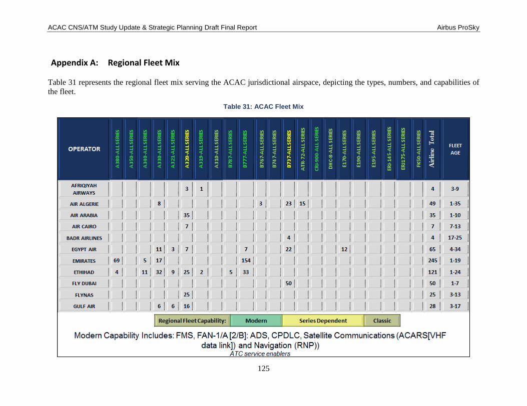
ACAC CNS/ATM Study Update & Strategic Planning Draft Final Report Airbus ProSky
125
Appendix A: Regional Fleet Mix
Table 31 represents the regional fleet mix serving the ACAC jurisdictional airspace, depicting the types, numbers, and capabilities of
the fleet.
Table 31: ACAC Fleet Mix

ACAC CNS/ATM Study Update & Strategic Planning Draft Final Report Airbus ProSky
126
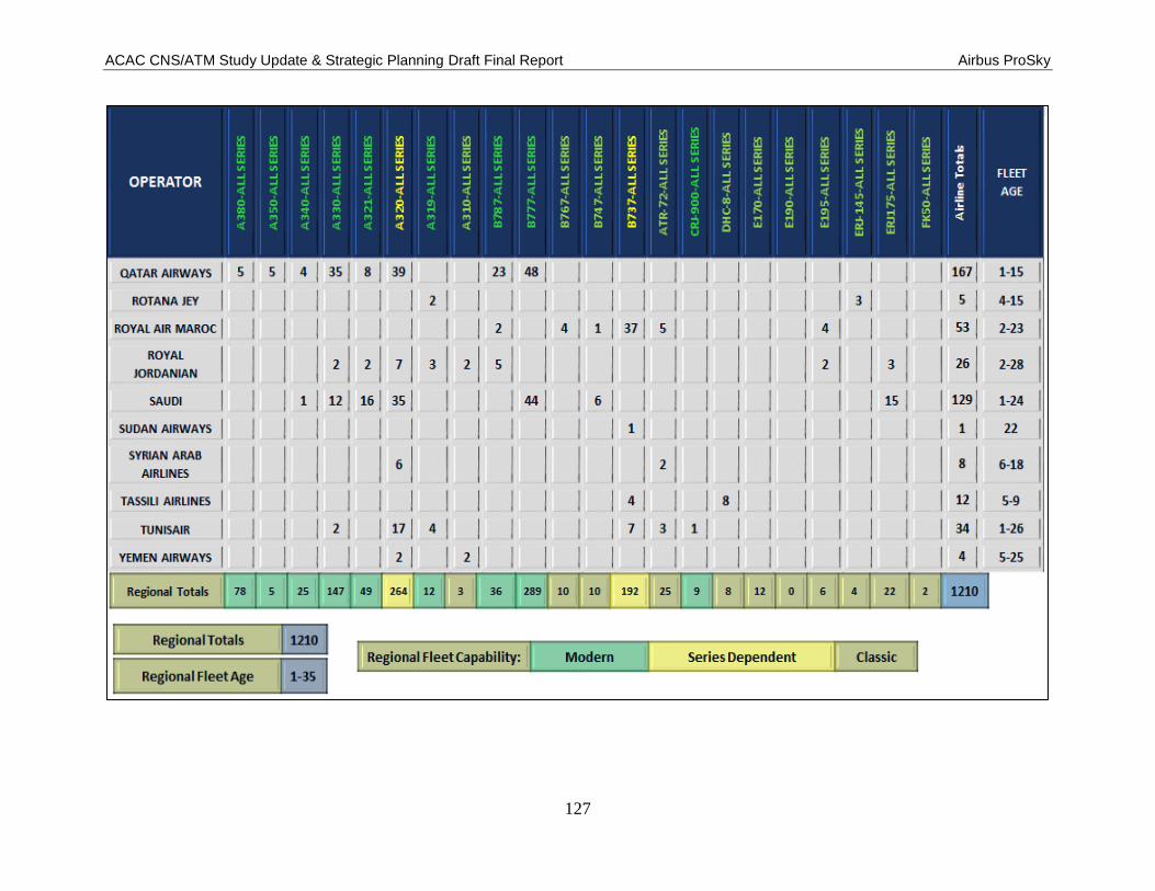
ACAC CNS/ATM Study Update & Strategic Planning Draft Final Report Airbus ProSky
127