Application of Geophysical Exploration for Environmental...
13
- 1 - Application of Geophysical Exploration for Environmental Earth Sciences and Engineering Satoru Ohya OYO Corporation, 4-2-6 Kudan-kita, Chiyoda-ku, Tokyo 102-0073, Japan. ABSTRACT The role of geophysics in Environmental Earth Sciences and Engineering is considered. In the developing era since 60’s in Japan, geophysics has mainly contributed to investigation of new constructions such as tunnels, dams and high-rise buildings. In the coming sustainable era, geophysics must be used for maintaining the safe and easy human life. Application examples of geophysics to investigations for disaster prevention, maintenance of existing constructions and soil and groundwater pollutions are presented to demonstrate their role in Environmental Geo-engineering. Future subjects in this field for geophysics and geophysicists are also discussed. INTRODUCTION Environmental problems will be definitely one of major social problems in this century. Many academic and engineering societies including the Society of Exploration Geophysicists of Japan, therefore, have paid their attention to the environmental issues in recent years. I have thought that environmental problems include many problems relating to human life such as natural disasters due to earthquakes and volcanic activities, and various accidents due to existing constructions as well as environmental pollutions. Therefore multi-disciplinary approaches should be taken to solve the environmental problems. I would like to call such multi-disciplinary science and technology as “ Environmental Geo-engineering”. In this paper, I will consider the role of exploration geophysics in Environmental Geo-engineering in the future. HISTORY OF APPLICATION OF GEOPHYSICS IN JAPAN AND ITS FUTURE Contribution of geophysics in the developing era in Japan In the 60’s in Japan, geophysics has been mainly used for exploration of mineral resources. As new development of mineral resources has been declining, geophysics has been employed for development of geothermal energy and groundwater in natural resources exploration. Its applications to development of coal and metal mines, however, have been decreasing. After the year of 1960 in Japan, large budgets have been invested to construct new infrastructures as shown in Figure 1. Geophysics has been employed in such large projects. For example, it has been used in investigation of construction of new dams at rivers, tunnels and man-made slopes for railroads and highways, and nuclear power plants. In Japan, earthquake ground motion must be taken into consideration in the design of construction. Since Niigata Earthquake in 1964 arose liquefaction in
Transcript of Application of Geophysical Exploration for Environmental...

- 1 -
Application of Geophysical Exploration for Environmental Earth Sciences and Engineering
Satoru Ohya OYO Corporation, 4-2-6 Kudan-kita, Chiyoda-ku, Tokyo 102-0073, Japan.
ABSTRACT
The role of geophysics in Environmental Earth Sciences and Engineering is considered. In the
developing era since 60’s in Japan, geophysics has mainly contributed to investigation of new
constructions such as tunnels, dams and high-rise buildings. In the coming sustainable era,
geophysics must be used for maintaining the safe and easy human life. Application examples of
geophysics to investigations for disaster prevention, maintenance of existing constructions and soil
and groundwater pollutions are presented to demonstrate their role in Environmental
Geo-engineering. Future subjects in this field for geophysics and geophysicists are also discussed.
INTRODUCTION
Environmental problems will be definitely one of major social problems in this century. Many
academic and engineering societies including the Society of Exploration Geophysicists of Japan,
therefore, have paid their attention to the environmental issues in recent years. I have thought that
environmental problems include many problems relating to human life such as natural disasters due
to earthquakes and volcanic activities, and various accidents due to existing constructions as well as
environmental pollutions. Therefore multi-disciplinary approaches should be taken to solve the
environmental problems. I would like to call such multi-disciplinary science and technology as
“ Environmental Geo-engineering”. In this paper, I will consider the role of exploration geophysics
in Environmental Geo-engineering in the future.
HISTORY OF APPLICATION OF GEOPHYSICS IN JAPAN AND ITS FUTURE
Contribution of geophysics in the developing era in Japan
In the 60’s in Japan, geophysics has been mainly used for exploration of mineral resources. As
new development of mineral resources has been declining, geophysics has been employed for
development of geothermal energy and groundwater in natural resources exploration. Its applications
to development of coal and metal mines, however, have been decreasing.
After the year of 1960 in Japan, large budgets have been invested to construct new infrastructures
as shown in Figure 1. Geophysics has been employed in such large projects. For example, it has been
used in investigation of construction of new dams at rivers, tunnels and man-made slopes for railroads
and highways, and nuclear power plants. In Japan, earthquake ground motion must be taken into
consideration in the design of construction. Since Niigata Earthquake in 1964 arose liquefaction in

- 2 -
wide area, soil dynamics and S-wave technology that both are very important to understand
liquefaction have been developed. Using such knowledge and technology, the seismic hazard map
technique that can predict earthquake ground motion and damage at the surface has been developed.
0
10
20
30
40
50
60
70
80
90
1955
1957
1959
1961
1963
1965
1967
1969
1971
1973
1975
1977
1979
1981
1983
1985
1987
1989
1991
1993
1995
1997
1999
뼬듩뙕먠뱤럱뒂 (뮎?걂
뚺떎뙕먠뱤럱뒂 걁뮎?걂
Private invesment (trillion yen)
Public invesment (trillion yen)
Fig.1 Annual investment to new constructions and budgets for new road plans
Budgets for roads
1st Oil Shock
2nd Oil Shock
Bubble, Cold war Ceased
11th
10th
9th
8th
7th
6th
5th4th
3rd
New plan
After the economic fever called as “Bubble” and the cold war have ceased in 1990 in Japan,
economic recession caused reduction of investments to new constructions. However due to in-balance
of trades between U.S.A. and Japan, Japanese government has tried to stimulate its economy through
investments to public works such as constructions of new highways and high speed railroads. In these
large projects, geophysics has been still applied successfully.
Contribution of geophysics in the sustainable era in Japan
The Great Hanshin Earthquake occurred in 1995 killed more than 6,000 people. Since the
earthquake arose the largest damages after the World War II in Japan, we were forced to reexamine the
earthquake-resistant design. Thanks to this earthquake, it was first recognized that deep subsurface
structure should be considered for predicting earthquake ground motion. Then deep seismic reflection
and gravity methods have started to be used to delineate deep subsurface structure for that. Until that
time, deep seismic reflection has been mainly used for oil and gas exploration. After the earthquake, it
has been actively used for investigation of active faults and deep subsurface structure for earthquake
disaster prevention. This earthquake, therefore, became a milestone in the application of geophysical
methods to earthquake disaster prevention.
Recently many volcanoes in Japan such as Unzen-Fugendake, Usu and Miyakejima have erupted
and damaged largely. Rock failure and landslide due to heavy rainfall have often occurred. It is not so
easy for us to mitigate these natural disasters because Japan has many volcanoes and is mainly

- 3 -
occupied by mountains. Geophysical methods are expected to be applied to mitigation of natural
disaster.
As mentioned above, in these thirty years after 1970 in Japan, huge amount of budgets have been
spent to construct new roads and railways and also many high-rise buildings have been constructed. In
these constructions, huge amount of concrete has been used. 80% of total amount of concrete so far
has been used in these thirty years. Large amount of concrete requires large amount of sands.
Therefore even low quality sands have been used for making concrete in these years. Such low quality
sands accelerate deterioration of the concrete and shorten its durable years. As shown in Figure 2, 15
to 20 years later, most of these concretes must cause any accidents due to their deterioration. Therefore
the role of investigation techniques for health of the concrete will become much more important in the
future. Geophysical methods are expected to be non-destructive techniques for testing the concrete
construction.
Fig.2 (1) Annual constructions of concrete bridges (afterKobayashi, 1999)
Fig.2 (2) Number of concrete bridges reaching their durable yearsin the future (after Kobayashi, 1999)
Num
ber(x104)
Num
ber
Year

- 4 -
In the second half of 20 century, Japan has been industrialized very rapidly. In this period, Japan
has imported materials from abroad and exported the products made by these materials. In the course
of production, huge amount of wastes have been created and disposed into the ground in and around
the factory. These wastes are getting polluted soils and groundwater around the factory. Investigations
for remediation of polluted soils and groundwater have been already carried out at many sites. There
may be much larger amount of environmental pollutions in Japanese islands as a negative legacy of
20th century. In solving these problems, geophysical methods should play an important role.
If the second half of 20th century in Japan is considered as “ the developing era ” or “ new
construction era ”, 21st century should be the era in which disaster prevention and environmental
protection must be much more important for sustaining safe and easy human life. Maintaining the
existing construction and technology for its health investigation also become more important in this
century. New application and contribution of geophysical methods must be requested in the
sustainable era. The Environmental Geo-Engineering must be an integrated science which consists of
many related fields such as geology, soil mechanics, rock mechanics, groundwater hydrology,
geochemistry, biology, microbiology and so on. To solve environmental geo-engineering problems,
these many kinds of technologies should be used synergistically. What contribution geophysics can
make is the subject for geophysicists and geophysical societies to consider in the new era.
I think that such contribution has been already made in a part of Environmental Geo-Engineering
field, but not yet systematically done. It is very difficult to demonstrate it systematically at this
moment. I will, therefore, present some actual field examples of applications of geophysics to
Environmental Geo-Engineering in order to demonstrate its role in this field.
APPLICATION EXAMPLES OF GEOPHYSICS TO ENVIRONMENTAL GEOENGINEERING
Geophysical methods enable us 1) to investigate a wide area very efficiently, 2) to investigate
non-destructively, 3) to image invisible underground. These features can be very important for
Environmental Geo-Engineering applications. For instance, in the investigation for soil and
groundwater pollution, we should first pick up heavily polluted areas in a very wide investigation site
and then predict the volume and degree of pollution of the polluted soil and groundwater with as
non-destructive way as possible. The examples in the following sections demonstrate these features.
Applications of geophysics to investigation for disaster prevention
As mentioned above, after the Great Hanshin Earthquake, geophysical methods have been
actively used in investigation for earthquake disaster prevention. Especially, it has been recognized
that deep seismic reflection and gravity methods are almost always necessary for delineation of active
faults and deep subsurface structure in investigation for earthquake disaster prevention.
Figure 3 shows an example of the deep seismic reflection profiles conducted just after the Great

- 5 -
Hanshin Earthquake (Endo et al., 1995). This profile shows abrupt change of the depth of the base rock
beneath the Kobe city, which caused the large damaged zone called as “Seismic Hazard Belt”. In
investigation of an active fault, trench survey is very important for evaluation of activity of the fault.
The length of a trench is usually of several meters. To determine an optimum trench point, shallow
seismic reflection can be also effectively used. Figure 4 shows an example of the very shallow seismic
reflection profile in the investigation of an active fault along the Median Tectonic Line. This profile
clearly shows the location of the fault and deformation of sediments around it due to faulting. Based on
the profile, three boreholes and a trench were dug to reveal the history of activity of the fault
(Tokushima Pref., 2000).
Fig.3 Seismic reflection profile beneath Kobe city (after Endo et al., 1995)
Fig.4 Very shallow seismic reflection profile at an active fault (after Tokushima Pref., 2000)
Depth(m
)
0
1000
200m
Depth(m
)
(m)
Fault
Base rock
Sediments

- 6 -
The “Seismic Hazard Belt” in the Great Hanshin Earthquake was caused by interference of
seismic waves due to the abrupt depth change of the base rock. It reminded us that deep subsurface
structure as well as near surface sediments should be considered for predicting earthquake ground
motion accurately. Then a nationwide investigation project of deep subsurface structure has started
first in three sedimentary basins in Kanto, Nohbi and Kyoto districts. For this kind of investigation, to
estimate three-dimensional S-wave velocity structure is most important because S-wave is generally
predominant in earthquake ground motion. In these investigations, one- or two-dimensional P- and
S-wave velocity profiles obtained by seismic reflection and micro-tremor array measurements were
expanded into three-dimensional P- and S-wave velocity structure, being guided by three-dimensional
gravity data. Figure 5 shows the three-dimensional subsurface model thus obtained in the Kyoto basin
(Kyoto city, 2001)
Recently the remote-sensing technology using the satellite has been rapidly developed.
Especially interferometric SAR (Synthetic Aperture Radar) processing enables us to detect subtle
surface deformation due to an earthquake, which has contributed to understand fault movement due to
an earthquake. This technology is also applied to detection of ground subsidence due to the large
amount of groundwater use. Any effective methods to detect ground subsidence in wide area are
required for predicting and preventing it in the future. Nakagawa et al. (1999) has successfully used
the interferometric SAR technology for this purpose. Figure 6 shows the SAR interferogram detecting
several cm scale of ground subsidence in Northern Kanto Plaines, where many ground subsidences
caused by the large amount of groundwater use.
Fig.5 Three-dimensional subsurface model of the Kyoto basin (after Kyoto City, 2001)
Perspective View of North-South section

- 7 -
Applications of geophysics to investigation for maintenance of existing constructions
After the accident of drop of a concrete block at the Sanyo Shinkansen Railway tunnel recently,
almost all tunnels of railways and roads in Japan have been inspected to prevent future accidents.
Inspection results revealed that the quality of concrete and its inspection method should be reexamined.
As mentioned above, 15 to 20 years later, most of concrete constructions will reach their durable years
and also the durable years should be extended to use them longer than before because new
construction must be reduced in the coming low economical growth era. For that reason, quality
control and maintenance of constructions must be much more important than before.
For long constructions such as tunnels, quick and inexpensive inspection techniques are required.
At present visual inspection and sonic inspection with the hammer are commonly used for inspection
of concrete constructions. However such manual inspection techniques need trained engineers whose
number will decrease in the future. In addition, these methods are neither effective nor objective. For
making periodic inspection more efficient and repeatable, automatic inspection techniques should be
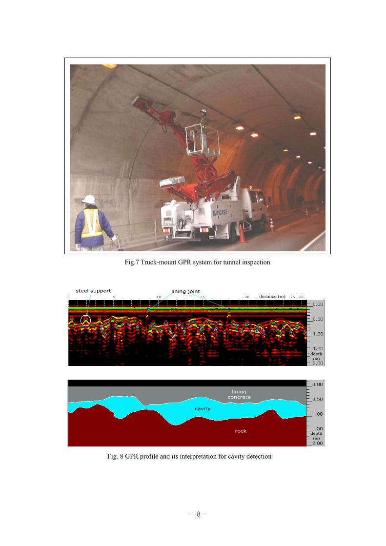
developed (Uomoto, 2000). The geophysical method commonly used for tunnel inspection is the GPR
(Ground Penetrating Radar). Figure 7 shows a truck-mounted GPR system for tunnel inspection. This
system can conduct several km-long profiles a day with continuous measurement using two antennae.
Figure 8 shows an example of GPR profiles and its interpretation at a tunnel obtained by this system.
From the profile, cavity was detected behind the concrete tunnel wall.
Fig. 6 Ground subsidence detected by the interferometric SAR(after Nakagawa et al., 1999)
- 8 -
0 10 20 265 15 25
depth(m)
distance (m)
liningconcrete
cavity
rock depth(m)
steel support lining joint
Fig. 8 GPR profile and its interpretation for cavity detection
Fig.7 Truck-mount GPR system for tunnel inspection

- 9 -
For inspection of the concretes of existing buildings and bridges, distribution of reinforced bars
and their degree of corrosion are often inspected. In such case, a small and high frequency GPR system
is employed. Figure 9 shows 1.5GHz GPR system and its application to detection of reinforced bars in
a concrete slab. Such a small and compact GPR system is very useful for detailed inspection of a
building.
Maintenance of existing dams and river embankments is also very important for safety. Many of
old dams have the problems of water leakage. In case of maintenance of a fill-type dam, strain meters
and pore pressure meters buried in the dam are commonly used for monitoring deformation or water
content of the soil. However only with these point-based measurements, it is not so easy to monitor the
whole body of the dam. Mori et al. (2000) has thus proposed the application of time-lapse resistivity
tomography using electrodes buried at many locations in the dam. The time-lapse resistivity
tomograms can visualize temporal changes of resistivity distribution in the dam, which may indicate
temporal changes of water contents and temperature of soils in the dam required for maintenance.
Figure 10 shows the temporal changes of resistivity profile in a section perpendicular to the axis of the
dam. This profile indicates water invasion into the dam body.
For maintenance of constructions, monitoring of temporal changes of the material properties is
very important for early detection of deterioration and making an effective repair plan. Time-lapse
geophysical methods should be promoted for this kind of application in the future.
0 50 100 150 200 240cm
0
50
100
120cm0102030cm
ƒ�ƒCƒhƒAƒ“ƒOƒ‹–@‘ª�ü
’T�¸‘ª�ü
ŠÛ�|ƒÓ20
D25 D32 D51
D38
º±”²‚«‰Ó�Š10cm20cm
40cm
20cm
’ê Ê�A‘¤ Ê ð h� ‰Á�H
28“úŒo‰ßŒã‚‘u�F32N/mm
0 100 200 ‹——£(cm)
Žž
ŠÔ(ns)
“S‹Ø”½ŽË”g ’ê–Ê”½ŽË”g
Fig. 9 High frequency GPR system and its profile
Antenna
Recorder
Reflection fromiron bar
Reflection from the bottom
Measurement line

- 10 -
Applications of geophysics to soil and groundwater pollution
In investigation of soil and groundwater pollution, geophysical methods can be used as a tool for
1) estimating the polluted area and its degree of pollution, 2) detection of source of pollution, 3)
understanding the mechanism of pollution and 4) monitoring of remediation. For instance, there is no
effective technique other than shallow geophysical mapping techniques for detection of drum cans
containing contaminant in a huge investigation area. To predict flow paths of contaminant in a soil
with groundwater, it is crucial to estimate distribution of impermeable layer and flow characteristics of
groundwater three-dimensionally, to which geophysical methods can contribute.
Self-potential or streaming potential methods have been proposed as a tool for estimating flow
characteristics of groundwater. It is well known that electrical potential (streaming potential) is
generated when groundwater flows in permeable subsurface layer. Therefore such electrical potential
measurements due to groundwater flow can be used for monitoring remediation process of polluted
groundwater. Figure 11 presents a field experiment of monitoring groundwater flow using the
self-potential method. Streaming potential vectors visualize the groundwater flows around the
pumping-up well.
�-10 NS-2 �面 �比比比 比比
�-11 EW �面 �比比比 比比
Temporal resistivity change rate on the sectionperpendicular to the model dam axis.
Fig. 10 Time-lapse resistivity tomogram at a fill-type dam (after Mori et al., 2000)
Temporal resistivity change rate on the sectionparallel to the model dam axis.
Variation (%)
Variation (%)
Upstream Downstream
West East

- 11 -
If geophysical methods can directly detect contaminant in soils or groundwater, they must
contribute much more to environmental applications. There are a few trial field experiments of
detection of oil, organic chemicals and heavy metals using GPR, electric and electromagnetic profiling
techniques together with laboratory tests and database analysis. Figure 12 shows an example of field
experiments of direct detection of contaminant using the DC resistivity profiling. In this case, a
tetrachloroethylene plume was detected as a high resistivity anomaly in the profile (Maekawa and
Nakajima, 1998).
Fig. 11 Visualization of groundwater flow by streaming potential measurements (after Sato et al., 1997)
Fig. 12 Resistivity profile at the contaminated site (after Maekawa and Nakajima, 1998)
Pumping-up well
Observation point
Observation location Streaming potential vector

- 12 -
FUTURE PROBLEMS THAT GEOPHYSICISTS SHOULD TACKLE
In general, many problems in earth sciences or geo-engineering are solved through the following
three steps.
Firstly, a geological or geotechnical model for solving the problem is constructed and its
parameters are estimated. Geophysics can contribute very much to this step and has contributed so far.
As mentioned in the examples of earthquake disaster prevention, an accurate subsurface model as well
as a source model is required for predicting earthquake ground motion correctly. Geophysical methods
such as seismic reflection and gravity methods are used to make a subsurface model.
Secondly, simulation is done using the model obtained in the first step for predicting phenomena
that will arise. There are already many simulators for oil and gas reservoir, wave propagation and
groundwater flow. These simulators have been actively used in Environmental Geo-engineering.
Finally, the simulated results are verified by observing and monitoring actual phenomena.
Geophysical methods can contribute to this step as a monitoring tool. As mentioned above, the
self-potential method can be used to visualize groundwater flow. It can help to make the remediation
process of groundwater contaminant more effective.
In geological or geotechnical investigations, in the developing or new construction era in Japan,
geological model at the site is mainly requested for planning and designing constructions. Therefore
geophysical methods have been employed mainly to make the geological model. However, in the new
sustainable era in the future, in which disaster prevention, maintenance and environmental protection
become main issues for us, geophysics will be requested to contribute to all three steps above. For
example, in recent years, when a new tunnel is planned, effect of tunnel excavation to groundwater
around the route should be studied before construction. In that case, three-dimensional subsurface
permeability model around the route is constructed to simulate groundwater flow. The simulation is
verified by observation of groundwater at the wells in the site. If influence of excavation to
groundwater is predicted, any countermeasures in the construction stage should be proposed. In such
case, if geophysical methods can provide a three-dimensional permeability model through
interpretation of physical parameters such as resistivity and velocity, and monitoring techniques of
groundwater in place of observation wells, the role of geophysics will become much more important in
Environmental Geo-Engineering applications.
In the future, geophysicists must be requested to understand the objectives of the whole project,
to develop technologies required for the application and to apply them as effectively as possible.
CLOSING REMARKS
Geophysics has been so far mostly used for exploration of natural resources and subsurface
structure. For such applications, geophysics is used at the place far away from our daily life.
However in the future, geophysics must be requested to contribute to constructing and maintaining
the safe and easy human life. In such case, the method must be used at the place much closer to our

- 13 -
daily life than before. Therefore geophysicists must be also requested to develop the safe and easy
methods.
REFERENCES
Endo, H., Watanabe, S., Makino, M., Murata, Y., Watanabe, K., and Urabe, A., 1995, Subsurface
geological structure with special reference to concealed faults and basement structure in Kobe and
Ashiya cities, Hyogo Pref., Japan: BUTSURI-TANSA (Geophysical Exploration), 48, 439-450 (in
Japanese).
Kobayashi, K., 1999, Concrete in danger: Iwanami, Tokyo (in Japanese).
Kyoto City, 2001, Investigation of subsurface structure beneath Kyoto City: Abstract of the 2nd
review meeting of investigation of subsurface structure beneath the sedimentary basin, 69-78 (in
Japanese).
Maekawa, T., and Nakajima, M., 1998, Present status and future direction in investigation and
measurement of groundwater pollution: Geology and Investigation, 3, 14-20 (in Japanese).
Mori, M., Natsuka, I., Hatakeyama, M., Toshioka, T., and Sakurai, K., 2000, Planned new safety
control system of the fill-type dam at Takashiba: Soil and Water, 123, 22-31 (in Japanese).
Nakagawa, H., Murakami, M., Fujiwara, S., and Tobita, M., 1999, Land subsidence of the Northern
Kanto Plains detected by JERS-1 SAR interferometry: Journal of the Geodetic Society of Japan,
45, 347-350 (in Japanese).
Sato, H., Shima, H., and Sakurai, K., 1997, A study on generation of streaming potential due to
pumping-up of groundwater: Proc. of the 97th technical conference of SEGJ, 279-282 (in
Japanese).
Tokushima Prefecture, 2000, Investigation report of active faults in Tokushima Prefecture (in
Japanese).
Uomoto, T., 2000, Maintenance of concrete structures in the 21 century: BUTSURI-TANSA,
(Geophysical Exploration), 53, 499-506 (in Japanese).