Application of Enhanced Ground Geophysical Data...
8
ScienceAsia 33 (2007): 257-264 Application of Enhanced Ground Geophysical Data to Active Fault Analysis in the Southern Sri Sawat Fault Segment, South of Srinakarin Dam, Western Thailand Viriya Danphaiboonphon, a,c,d Punya Charusiri a* and Weera Galong b a Earthquake and Tectonic Geology Research Unit, c/o Department of Geology, Faculty of Science, Chulalongkorn University, Bangkok 10330, Thailand. b Bureau of Minerals, Department of Mineral Resources, Bangkok 10400, Thailand. c Present address: PTT Exploration and Production Public Company, 555 PTT Office Building, Vibhvadi- Rangsit Rd., Chatuchak, Bangkok 10900, Thailand. d E-mail address: [email protected] * Corresponding author, E-mail: [email protected] Received 13 Jun 2005 Accepted 15 Feb 2007 ABSTRACT: The study area (approximately 5,000 m 2 ) in Sri Sawat, Kanchanaburi province, is occupied by the Quaternary deposits and Triassic sedimentary rocks. This area is about 3 km to the south of the Srinakarin Dam located in the southern part of the Sri sawat fault. Main structural features in the area are northwest- trending normal faults as clearly recognized from aerial photographs and satellite imageries. The fault segments, common at the foothill, are dominated by Triassic sedimentary strata. The prime objective of this study is to recognize Quaternary fault zones using ground geophysical methods including magnetic, very low frequency electromagnetic (VLF-EM) and resistivity. Five survey lines of ground geophysical survey (100 m long) with traverse line of 10 m and 5 m of sample spacing interval are assigned in the northeast trending perpendicular to the inferred main geological structure. About 100 stations were selected for measurement, and all data were enhanced using the GEOSOFT and VLF PAK programs. The result indicates that, the fault zone shows higher resistivity values and lower magnetic and VLF-EM responses than those of the mudstone country rocks. The ground geophysical results reveal two systems of faults; both are shallow (at about 0-5 m below surface) and orient in the northwest-southeast trend with opposite dip directions. The fault almost at the northern end is very close to the foothill and is considered to be the major fault. This fault strikes in the northwest-southeast direction, dips to the southwest apparently less than 45° and crosscuts Triassic rocks. This major fault, however, is regarded as “less potentially active” fault. The other faultis regarded as the minor and antithetic fault, and located in the Quaternary deposit at southern end. It strikes northwest-southeast and dips to the northeast at the same angle. This fault is recorded as a minor fault possibly crosscutting the Quaternary colluvial sediments, and is considered to be the active fault. KEYWORDS: Sri Sawat Fault, Kanchanaburi, Resistivity method, Magnetic method, VLF-EM method. INTRODUCTION Earthquake becomes a common natural disaster that has an extreme and vigorous destruction. One of the causes generating earthquakes is the earth movement along an active fault. In some parts of Thailand, particularly those of the northern and the western regions, earthquake activities were recorded not only by historical/archaeological means but also by instrumental approaches. Two major faults in Kanchanaburi, western Thailand - the Sri Sawat and the Three Pagoda Faults- are documented to be associated with earthquake activities 1, 2 . Earlier maps, e.g. those generated by Bunopas 3 and Shretha 4 , show that these two fault zones cut across many kinds of rocks ranging in ages from Precambrian to Quaternary. The Sri Sawat Fault extends from the southeastern part of Myanmar through the western part of Thailand, with about 380 km in length. Its major trend is northwest- southeast. With the applications of several geologic and seismotectonic parameters, it has been assigned to be potentially active 4, 5 . Additionally, based on these parameters, Nuttee 6 subdivided the Sri Sawat Fault into 3 main segments –northern, central, and southern. At present, there are several methods applied to detect faults associated with earthquakes. McCalpin 7 noted that the most common geological approaches include geomorphic, geodetic, geochronological, and geophysical methods. The geophysical means, both from ground and airborne investigations, are proved to help interpret paleoseismic assessment successfully in several earthquakes–dominated regions 8,9 . Among the geophysical methods applied, ground magnetic and resistivity have been used widely in detecting doi: 10.2306/scienceasia1513-1874.2007.33.257
Transcript of Application of Enhanced Ground Geophysical Data...
ScienceAsia 33 (2007): 257-264
Application of Enhanced Ground Geophysical Data toActive Fault Analysis in the Southern Sri Sawat Fault
Segment, South of Srinakarin Dam, Western ThailandViriya Danphaiboonphon,a,c,d Punya Charusiria* and Weera Galongb
a Earthquake and Tectonic Geology Research Unit, c/o Department of Geology, Faculty of Science,Chulalongkorn University, Bangkok 10330, Thailand.
b Bureau of Minerals, Department of Mineral Resources, Bangkok 10400, Thailand.c Present address: PTT Exploration and Production Public Company, 555 PTT Office Building, Vibhvadi-
Rangsit Rd., Chatuchak, Bangkok 10900, Thailand.d E-mail address: [email protected]
* Corresponding author, E-mail: [email protected]
Received 13 Jun 2005Accepted 15 Feb 2007
ABSTRACT: The study area (approximately 5,000 m2) in Sri Sawat, Kanchanaburi province, is occupied by theQuaternary deposits and Triassic sedimentary rocks. This area is about 3 km to the south of the SrinakarinDam located in the southern part of the Sri sawat fault. Main structural features in the area are northwest-trending normal faults as clearly recognized from aerial photographs and satellite imageries. The faultsegments, common at the foothill, are dominated by Triassic sedimentary strata. The prime objective of thisstudy is to recognize Quaternary fault zones using ground geophysical methods including magnetic, verylow frequency electromagnetic (VLF-EM) and resistivity. Five survey lines of ground geophysical survey(100 m long) with traverse line of 10 m and 5 m of sample spacing interval are assigned in the northeasttrending perpendicular to the inferred main geological structure. About 100 stations were selected formeasurement, and all data were enhanced using the GEOSOFT and VLF PAK programs. The result indicatesthat, the fault zone shows higher resistivity values and lower magnetic and VLF-EM responses than those ofthe mudstone country rocks. The ground geophysical results reveal two systems of faults; both are shallow(at about 0-5 m below surface) and orient in the northwest-southeast trend with opposite dip directions. Thefault almost at the northern end is very close to the foothill and is considered to be the major fault. This faultstrikes in the northwest-southeast direction, dips to the southwest apparently less than 45° and crosscutsTriassic rocks. This major fault, however, is regarded as “less potentially active” fault. The other faultisregarded as the minor and antithetic fault, and located in the Quaternary deposit at southern end. It strikesnorthwest-southeast and dips to the northeast at the same angle. This fault is recorded as a minor faultpossibly crosscutting the Quaternary colluvial sediments, and is considered to be the active fault.
KEYWORDS: Sri Sawat Fault, Kanchanaburi, Resistivity method, Magnetic method, VLF-EM method.
INTRODUCTION
Earthquake becomes a common natural disasterthat has an extreme and vigorous destruction. One ofthe causes generating earthquakes is the earth movementalong an active fault. In some parts of Thailand,particularly those of the northern and the westernregions, earthquake activities were recorded not onlyby historical/archaeological means but also byinstrumental approaches. Two major faults inKanchanaburi, western Thailand - the Sri Sawat and theThree Pagoda Faults- are documented to be associatedwith earthquake activities1, 2. Earlier maps, e.g. thosegenerated by Bunopas3 and Shretha4, show that thesetwo fault zones cut across many kinds of rocks rangingin ages from Precambrian to Quaternary.
The Sri Sawat Fault extends from the southeastern
part of Myanmar through the western part of Thailand,with about 380 km in length. Its major trend is northwest-southeast. With the applications of several geologicand seismotectonic parameters, it has been assigned tobe potentially active4, 5. Additionally, based on theseparameters, Nuttee6 subdivided the Sri Sawat Faultinto 3 main segments –northern, central, and southern.
At present, there are several methods applied todetect faults associated with earthquakes. McCalpin7
noted that the most common geological approachesinclude geomorphic, geodetic, geochronological, andgeophysical methods. The geophysical means, bothfrom ground and airborne investigations, are provedto help interpret paleoseismic assessment successfullyin several earthquakes–dominated regions8,9. Amongthe geophysical methods applied, ground magneticand resistivity have been used widely in detecting
doi: 10.2306/scienceasia1513-1874.2007.33.257

2 5 8 ScienceAsia ScienceAsia ScienceAsia ScienceAsia ScienceAsia 33 (2007)33 (2007)33 (2007)33 (2007)33 (2007)
concealed and subsurface active faults10, 11. Recentlythe VLF-EM method has been used to detect suchactive faults in Japan12, Canada13, USA14, and KerhuelenIsland (France)15. Most of the geophysical studies inThailand have focused on occurrence of mineraldeposits and subsurface mineral exploration.
The objectives of this study are to determine faultorientation in the southern Sri Sawat fault segment usingground magnetic, resistivity and VLF-EM surveys and toapply these results to locate the most appropriate site forpaleoseismic trenching. This study seems to be the firststudy in Thailand that ground geophysical methods werefirst applied to paleoseismic analysis. Since the faultbeing investigated is near the dam site and theKanchanaburi city, it is necessary to understand if thefault is “active” or not. In this study, we define the activefault following the well-accepted definitions proposedby ICOLD16 and USGS17 as the fault reasonably identified,located, and known to have produced historicalearthquakes or showing geological evidence of Holocene(11,000 years) displacement and which, because of itspresent tectonic setting, can undergo movement duringthe anticipated life of man-made structures.
Location of the Study AreaLocation of the Study AreaLocation of the Study AreaLocation of the Study AreaLocation of the Study AreaThe study area is about 3 km in the southern part
of the Srinakarin Dam at Ban Kaeng Kab, Sri Sawatdistrict, Kanchanaburi province, Thailand (Fig 1). Thearea covering about 5,000 m2, is located at longitude
99°11′24′′E and latitude 14°20′3′′N (or UTM Grid 519500m
E – 519700m E and 1586200m N – 1586300m N). The study areais a part of 1:50,000 topographic map of Ban KaengRiang, sheet no. 4837IV, series L7017.Geomorphologically, the area where active fault isinterpreted to pass through18 is dominated by mountainand undulating area. Mountains have moderate to steepslopes and trend in the northeast-southwest directionwith their elevations ranging from 100 m to 500 mabove the present mean sea level. Geologically, rocksaround the survey area comprise 4 lithologies. Amongthese rocks, Triassic clastic rocks (unit B in Fig. 2b) aremostly related to study area. Several parts of them arecovered with colluvial deposits. Other rocks includePermian limestone, Cambrian quartzite, andQuaternary deposits (units D, E, and A in Fig. 2b)
PrPrPrPrPrevious Wevious Wevious Wevious Wevious WorksorksorksorksorksThere have not been many studies about
earthquakes done in Thailand. Mostly, those studiesconcerned regional areas1, 2. Siribhakdi1 reportedpresent-day seismicity in Thailand and her surroundingcountries, and studied epicenteral distribution inThailand back to the past 1,500 years. Many of theseearthquakes are recorded to have close relation withfour major faults, including the Three Pagoda, the Sri
Fig 1. Present-day tectonic map showing major active faultzones in the mainland Southeast Asia (after Charusiri etal. 2002). The location of the study area is on the SriSawat fault zone (shaded box).
Fig 2. a a a a a Aerial photograph showing the location of the alineaments which is interpret as a fault.
b b b b b Morphotectonic map covering the study areashowing triangular facets:A = Unconsolidated deposits (Quaternary), B = Shale,sandstone interceded with Limestone (Triassic), D =Limestone (Permian), E = Quartzite (Cambrian).
aaaaa
bbbbb

ScienceAsia ScienceAsia ScienceAsia ScienceAsia ScienceAsia 33 (2007)33 (2007)33 (2007)33 (2007)33 (2007) 2 5 9
Sawat, the Moei-Uthai Thani and the Mae Hong Son-Mae Sarieng Faults.
Klaipongpan et al.19 investigated geological andseismicity evaluation in April 1983 earthquake at theSrinakarin Dam. The results, obtained from theevaluation of overall characteristic seismicity andrevision of world wide data on seismic and geologiccharacteristics of reservoir triggered seismicity (RTS),are ensured to accept the high possibility of reservoirinduced seismicity phenomena.
Hinthong20 investigated the role of tectonic settingsin earthquake events in Thailand. He reported that theseismic source zone in Tenasserim range (or Zone F ofNutalaya et al.21) was responsible for the principal present-day northwest-southeast right-lateral strike slip FaultZones, i.e., the Moei Uthai Thani Fault, the Three PagodaFault, and the associated Sri Sawat Fault. Those faultsand fault zones are believed to be responsible for theearthquake activities in the western Thailand.
Sarapirome and Khundee22 presented a preliminarystudy on neotectonics in the Mae Hong Son-Khun Yuamvalley, northwestern Thailand. They used the statisticparameters including orientation and length oflineaments, data on earthquake epicenters, and hotsprings. In their studies, the Quaternary faults weregathered and analyzed in order to seek how these datacould be used to imply the neotectonics of their study.
Charusiri et al.23 applied several remote sensingtechniques in studying geological structures related toearthquakes in Thailand and neighboring countries.The result was useful for determining the seismic-sourcezones to indicate the earthquake-prone areas. A newseismo-tectonic (or seismic-source zone) map was alsoproposed.
Paleoseismic studies in the Srinakarin Dam studyarea are rare. Very recently Nuttee6 and Songmuang16
applied results of aerial photographic and landsat TM5interpretation to the study of active faults.
MATERIALS AND METHODS
MethodologyMethodologyMethodologyMethodologyMethodologyThe method of this study involved 5 consecutive
steps.The first step was to compile previous works and
pertinent data related to earthquakes and active faultsin the western Thailand. The second step was to definethe study area based on remote sensing results18 (Fig.2a & 2b) and airborne geophysical data (Fig.3) fordetailed ground geophysical survey. The third step wasto perform field operation and to collect geophysicaldata, which include a) magnetic method24, b) VLF-EMmethod25, and c) resistivity method26. The forth stepwas to process/analyze data, which involvedconversion of primary data to digital data and to
construct anomaly maps and sections with theassistance of software program. The last step was todelineate locations and orientation of active faults fromthose maps and profiles and to propose locations oftrenching for more-detailed paleoearthquakeexploration.
Survey DesignSurvey DesignSurvey DesignSurvey DesignSurvey DesignField investigation indicated that the Triassic
sedimentary strata display as a relatively flat plain at thesteeper angle foot slopes of the Cambrian quartzite. Ingeneral this plain is mostly covered by colluvial deposits.Result from remote-sensing interpretation (Fig.2b)revealed that the main structural lineament is in thenorthwest-southeast direction in the study area. Similar
Fig 3. Magnetic and VLF-EM air-borne data showing low-valueanomalies inferred herein as a fault in the study area.
Fig 4. Map showing ground geophysical survey lines orien-tated in the NE –SW direction roughly perpendicularto the main lineament structure interpreted from aerialphotograph, in the NW trend.
Table 1. Detail of survey lines used in the study area.
LineLineLineLineLine Azimuth ( Azimuth ( Azimuth ( Azimuth ( Azimuth ( o o o o o )))))Distance (m)Distance (m)Distance (m)Distance (m)Distance (m)Starting pointStarting pointStarting pointStarting pointStarting pointTTTTTerererererminal pointminal pointminal pointminal pointminal point
L00 40 o - 220 o 100 L00-00 L00-100L10 40 o - 220 o 100 L10-00 L10-100L20 40 o - 220 o 100 L20-00 L20-100L30 40 o - 220 o 100 L30-00 L30-100L50 55o - 235 o 100 L50-00 L50-100

2 6 0 ScienceAsia ScienceAsia ScienceAsia ScienceAsia ScienceAsia 33 (2007)33 (2007)33 (2007)33 (2007)33 (2007)
result was made for the interpretation from bothmagnetic and VLF-EM airborne data that there existsa fault situated at the same location (Fig. 3). Groundsurvey lines were therefore designed to beperpendicular to the main trend of the structurallineaments. Five survey lines were conducted in thenorthwest-southeast direction, with 10-m line spacing,and each almost perpendicular to the main structuralfeature. A total of 21 sample points from individualsurvey lines were collected in this study. The details ofthe entire survey lines are shown in Table 1 and Fig 4.
For the magnetic and VLF-EM surveys, we assignedrecord spacing of 5 m for collecting data and detectingsignals/anomalies based on method described byBriener24. For the resistivity survey, we applied the time-domain method to measure resistivity values at the
Fig 5. a a a a a Resistivity contour map at 10 m depth, the KaengKab area, Kanchanaburi.FF’ indicates the structural lineament (or fault).b b b b b Four in-line resistivity sections in the study area.Dashed lines in the section represent the interpretedfaults. Connection of individual sections indicates theapproximate fault plane orientation in the study area.
aaaaa
bbbbb
depths of 10, 15, 20, 25, 30, and 35 m based on dipole-dipole configuration array.
RESULTS
Resistivity MethodResistivity MethodResistivity MethodResistivity MethodResistivity MethodWe constructed resistivity contour maps and
resistivity profiles (both cross and long sections) fromdigital database using GEOSOFT program (Figs. 5a and5b). The color bar scale illustrates resistivity values.Contoured data are displayed in two-dimension andyield high accuracy in order to mark the position of thefault.
In this study, the resistivity values vary from 23.05to 83.68 ohm.m. Such value ranges are similar to thoseof the normal resistivity values for common
Fig 6. a a a a a The VLF-EM’s anomaly at L00 (a). VLF-EM responseshowing inphase, quadature, and fraser values along thesurvey line L00 at 22.3 kHz and 17.4 kHz frequencies.Two outstanding values F2 and F1 are marked close toboth ends of the survey line.
b b b b b An overlay of VLF-EM anomalies onto the magneticcontour map showing the major structural lineamentwith inferred significant anomalies orientating in theNW direction.
bbbbb
aaaaa

ScienceAsia ScienceAsia ScienceAsia ScienceAsia ScienceAsia 33 (2007)33 (2007)33 (2007)33 (2007)33 (2007) 2 6 1
sedimentary rocks27 (e.g. sandstone and shale).Therefore, based on the resistivity result and the fieldsurvey, we interpret that rocks beneath the study areawould be sedimentary. However, there are some pointdata that have lower values than the normalsedimentary rocks. There is a sharp boundary betweenrelatively high and low resistivity values in the middlepart of the study area, as shown by a color relief mapdetermined when the secondary electromagnetic fieldsshow different phase from the primary electromagneticfields. Generally, inphase values are positive componentwhile quadrature values are negative component ofthe secondary electromagnetic field from the target15.The Fraser filter values are also inphase values, whichare filtered in order to emphasize the positions ofanomalies. In another word, the input of Fraser filteris the way to enhance the visualization of the anomalypositions, as shown in Fig.6a. Two points (F
1 and F
2) are
quite obvious along each survey line (line L00 and L10)at both frequencies applied. At F
1 and F
2 points, all the
EM values are either much lower or higher than normalbackground values.
INTERPRETATION
From the result of resistivity contour maps at 10-m depths (Fig. 5a), the anomaly line is characterized bythe low resistivity continuity in the northwest-southeastdirection. This can be interpreted as a fault cuttingthrough Triassic sedimentary rock unit. Thus, the faultcan be detected obviously at the depth of approximately10 m (Fig 5a).
Besides, four resistivity survey lines also indicate alow resistivity anomaly zone. This can be easily seenwhen these sections were shown together (Fig 5b).These anomalies are at the same positions as thoseobserved in resistivity contour maps. Their trends inthe northwest direction and the moderate–angle withapparent dip not exceeding 45 degrees are observed.In the current investigation, the long section of thesurvey line L50, however, does not include in theinterpretation because the section is too far from theothers.
From the magnetic contour map and magneticprofiles (Figs. 7a to 7c), we interpreted that there is asharp contact between two contrasting magnetic valueslocated in the central part and in the northeast-southwest direction. The anomaly in the magnetic crossprofiles is regarded as the boundary contact (orstructural lineament zone) between two contrastingrock units of different properties, which yield themagnetic susceptibility values different from the others.Similar situation is also encountered in the magneticlong profiles (Fig. 7b), such as at the survey line L20,located in the southern part of the map, where the
discontinuity is observed.From the result shown as long profile and cross
profiles (see Figs 7a and 7b), we consider that two fault
Fig 7. a a a a a Magnetic map of the Kaeng Kab area, with theoverlay of cross profiles showing the continuousstructural lineament (dashed line, interpreted ascontact plane of two contrasting rock units). A solid linerepresents the shift of the structure lineament.bbbbb Magnetic map of the Kaeng Kab area, with the overlayof in-line profiles showing two dashed lines connectinglow magnetic values. These dashed lines (F1 and F2) areinterpreted structural lineament in the NW trend.
c c c c c Two fault zones (solid line) and a structural contactinterpreted from the magnetic contour map of the KaengKab area, Kanchanaburi.
bbbbb
aaaaa
ccccc
2 6 2 ScienceAsia ScienceAsia ScienceAsia ScienceAsia ScienceAsia 33 (2007)33 (2007)33 (2007)33 (2007)33 (2007)
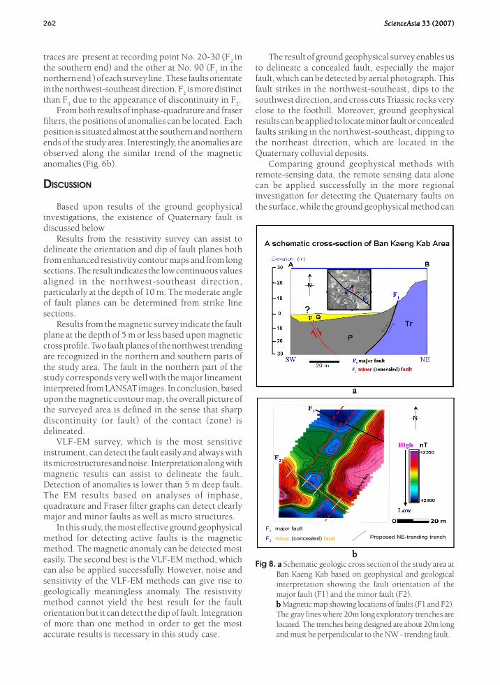
The result of ground geophysical survey enables usto delineate a concealed fault, especially the majorfault, which can be detected by aerial photograph. Thisfault strikes in the northwest-southeast, dips to thesouthwest direction, and cross cuts Triassic rocks veryclose to the foothill. Moreover, ground geophysicalresults can be applied to locate minor fault or concealedfaults striking in the northwest-southeast, dipping tothe northeast direction, which are located in theQuaternary colluvial deposits.
Comparing ground geophysical methods withremote-sensing data, the remote sensing data alonecan be applied successfully in the more regionalinvestigation for detecting the Quaternary faults onthe surface, while the ground geophysical method can
traces are present at recording point No. 20-30 (F2 in
the southern end) and the other at No. 90 (F1 in the
northern end ) of each survey line. These faults orientatein the northwest-southeast direction. F
2 is more distinct
than F1 due to the appearance of discontinuity in F
2.
From both results of inphase-quadrature and fraserfilters, the positions of anomalies can be located. Eachposition is situated almost at the southern and northernends of the study area. Interestingly, the anomalies areobserved along the similar trend of the magneticanomalies (Fig. 6b).
DISCUSSION
Based upon results of the ground geophysicalinvestigations, the existence of Quaternary fault isdiscussed below
Results from the resistivity survey can assist todelineate the orientation and dip of fault planes bothfrom enhanced resistivity contour maps and from longsections. The result indicates the low continuous valuesaligned in the northwest-southeast direction,particularly at the depth of 10 m. The moderate angleof fault planes can be determined from strike linesections.
Results from the magnetic survey indicate the faultplane at the depth of 5 m or less based upon magneticcross profile. Two fault planes of the northwest trendingare recognized in the northern and southern parts ofthe study area. The fault in the northern part of thestudy corresponds very well with the major lineamentinterpreted from LANSAT images. In conclusion, basedupon the magnetic contour map, the overall picture ofthe surveyed area is defined in the sense that sharpdiscontinuity (or fault) of the contact (zone) isdelineated.
VLF-EM survey, which is the most sensitiveinstrument, can detect the fault easily and always withits microstructures and noise. Interpretation along withmagnetic results can assist to delineate the fault.Detection of anomalies is lower than 5 m deep fault.The EM results based on analyses of inphase,quadrature and Fraser filter graphs can detect clearlymajor and minor faults as well as micro structures.
In this study, the most effective ground geophysicalmethod for detecting active faults is the magneticmethod. The magnetic anomaly can be detected mosteasily. The second best is the VLF-EM method, whichcan also be applied successfully. However, noise andsensitivity of the VLF-EM methods can give rise togeologically meaningless anomaly. The resistivitymethod cannot yield the best result for the faultorientation but it can detect the dip of fault. Integrationof more than one method in order to get the mostaccurate results is necessary in this study case.
Proposed NE-trending trench F1 major fault
F2 minor (concealed) fault
Fig 8. a a a a a Schematic geologic cross section of the study area atBan Kaeng Kab based on geophysical and geologicalinterpretation showing the fault orientation of themajor fault (F1) and the minor fault (F2).bbbbb Magnetic map showing locations of faults (F1 and F2).The gray lines where 20m long exploratory trenches arelocated. The trenches being designed are about 20m longand must be perpendicular to the NW - trending fault.
bbbbb
aaaaa
ScienceAsia ScienceAsia ScienceAsia ScienceAsia ScienceAsia 33 (2007)33 (2007)33 (2007)33 (2007)33 (2007) 263
assist to delineate concealed faults in the larger scaleand give more detail of subsurface data than remotesensing data.
Based upon interpretation of the Quaternary Faultby Songmuang18 together with the currentinterpretation of the enhanced ground geophysicaldata mentioned previously, the geologic cross sectionin the north northeast - south southwest directionthrough the study area could be constructed. The studyarea in Kaeng Kab village is mainly occupied by theQuaternary deposit in the middle part, Cambrian andTriassic clastic sedimentary rocks in the northern andPermian carbonates in the southern part. One majorfault is observed to cross cut the Permian and theTriassic sedimentary strata. The fault orientates in thenorthwest trend and dips southwestward at moderateangles. We regarded that this fault shows vertical slipdisplacement and is located clearly at the foothill. Theother which is a minor fault, is located about 60 m tothe south of the major fault. This minor fault cannot bedetected from using aerial photographic analysis. It iselevated about 5 m from the ground surface coveredby the Quaternary sediments (Fig 8). The fault cuts intothe Triassic sedimentary rocks and aligned in thenorthwest direction. However, its moderate angle tothe northeast is in the opposite sense to the major fault.Structurally, this minor fault is likely to be the “antitheticfault29”. It is probable that the movement along themajor fault caused the movement of the antithetic andminor fault in the past, since the antithetic fault cuttingsthrough Quaternary sediments can be constrained morefor younger movement than the much older sediments.Based on this poorly supported result, we thereforebelieve that the minor fault is more active at presentthan the major one. The major fault may have movedbefore, but now it becomes less important than theminor fault.
It is, therefore, reasonable to note that results onremote sensing interpretation alone can be appliedparticularly in the more regional scale for detectingQuaternary faults on the surface18, 30. However, theground geophysical survey, particularly the magneticmethod, can be employed to locate a concealed faultin a local scale.
Finally, results from the enhanced groundgeophysical data can define an appropriate area forpaleoseismic trenching from the interesting specificanomaly in order to cut down expenses and time. As aresult, gray solid lines in Fig. 9 (about 10 m long)perpendicular to the F2 fault in the south are proposedfor the trenching.
CONCLUSION AND RECOMMENDATION
Results from magnetic, VLF-EM, and resistivity
survey show that in this study the most effective groundgeophysical method for detecting the geometry of theconcealed faults is the magnetic method. However theVLF-EM method is successful and can be applied todetect faults at shallower depth (5 m) than the magneticsurvey. This kind of EM method can be best applied fordetecting faults in Quaternary deposits. Enhancedground geophysical methods seem to be more effectivethan the remote sensing methods in terms of theiraccuracy in locating faults.
This study indicates that the southern part of the SriSawat fault is “active” because the fault detected cutsacross colluvial sediments of the Quaternary. However,more detailed study such as paleoseismic trenchingand dating, can be carried out after interpretation ofcombined geological results has been performed. It isalso recommended that survey lines should be designedin smaller record spacing such as 1 m instead of 5 m inorder to detect fault planes at shallower depth.
ACKNOWLEDGEMENTS
The project is partly funded by the ThailandResearch Fund through P. Charusiri and the Departmentof Geology, Chulalongkorn University. The gratefulacknowledgement goes to the Department of MineralResources (DMR) Thailand, for contributingequipments and the collaboration during fieldworkand geophysical survey. Thanks are also to R.Songmuang, M. Ruksasakulwong and especially to theofficers of Geotechnique Division, DMR, for fruitfuldiscussion and suggestion in the field. Two anonymousreviewers are thanked for their fruitful comments.
REFERENCES
1. Siribhakdi K (1985) Seismic of Thailand and periphery.Geological Survey Division, Department of MineralResources, Bangkok, Thailand, 151-8.
2. Charusiri P, Chaturongkavanich S, Takashima I, Kosuwan S,Won-In K, and Ngo Ngoc Cat (2000) Application ofgeothermal resources of Thailand, Vietnam, and Myanmarto tectonic settings. In: Proceedings of the World GeothermalCongress. Kyush-Tohoku, Japan, organized by InternationalGeothermal Association, May 28 June 10, 2000: 1043-7.
3. Bunopas S (1976) Geology of map Changwat Suphan Buri,Sheet ND 47-7, Scale 1:250,000. Report of Investigation,1616161616, Department of Mineral Resources, Bangkok.
4. Shrestha P M (1987) Investigation of active fault inKanchanaburi Province, Thailand. Master ,s thesis, GraduateSchool, Asian Institute of Technology, Bangkok.
5. Charusiri P, Kosuwan S, Lumjuan A and Wechbunthung B(1998) Review of active faults and seismicity in Thailand. In:Proceedings of the Ninth Congress on Geology, Mineral,and Energy Resourses of Southeast Asia-GEOSEA’ 98’andIGCP 383, symposium 17-19 August 1998, GeologicalSociety of Malaysia, Kuala Lumpur, Malaysia, 653-65.
6. Nutee R (2002) Young faulting along the southern of Sri

264 ScienceAsia ScienceAsia ScienceAsia ScienceAsia ScienceAsia 33 (2007)33 (2007)33 (2007)33 (2007)33 (2007)
Sawat fault, Sri Sawat district, Kanchanaburi. An unpublishedM.Sc. thesis, Chulalongkorn University, Bangkok.
7. McCalpin J P and Nelson A R (1996) Introduction topaleoseimology. In: Paleoseimology (Edited by McCalpin JR), Acadimic Press, N1-3ew York, 2.
8. Baldwin J N, Knudsen K L, Lee A, Prentice C S and Gross R(2000) Preliminary estimate of coseismic displacement ofthe penultimate earthquake on the northern San Andreasfault, Point Arena, Califonia: in Bokelman, G. and Kovachs,R. (eds.) Tectonic problem of the San Andres Fault System,Stanford University Publication, 355-68.
9. Yarger H L (1978) Diurnal drift removal from aeromagneticdata using least square. Geophysics, 4646464646,1148-56
10. Shields G et al (1997) Shallow geophysical survey across thePahrump valley fault zone, California-Nevada Border. Bulletinof the Seismological Society of America, 8888888888, 270-5.
11. Atakan K, Midzi V, Toiran B M, Vanneste K, Camelbeeck T,and Meghraoui M (2000) Seismic hazard in regions of presentday low seismic activity: uncertainties in the paleoseismicinvestigations along the Bree Fault Scarp (Roer Graben,Belgium). Solid Dynamics and Earthquake Engineering, 2020202020(5-8), 415-27.
12. Hata M, Takumi I, and Yasukawa H (2000) Erectromagnetic-wave radiation due to diastrophism of magma dike growthin Izu-Miyake, Volcanic eruption in Japan in 2000. NaturalHazard and Earth System Sciences, Eurapean GeophysicalSociety, 43-51.
13. Diakow L J and van der Hyden P (1995) An overview of theinterior plateau program. British Columbia Geological SurveyBranch, Canada, 53-6.
14. Olhoeft G R (2000) Hot and cold lava tube characterizationwith ground penetrating radar, SPIE Proceedings Series. In:Proceedings of the Eighth international conference onGround penetrating radar (Edited by D. A. Noon and others),40844084408440844084, 482-7.
15. Parrot M, Lefeuvre F, Corcuff V, and Godfroy P (1985)Observation of VLF emission at the time of earthquake inthe Kerguelen Islands. Ann. Geophys., 3(6),3(6),3(6),3(6),3(6), 731-6.
16. ICOLD (1989) Selecting seismic parameters for large dams,Guidelines, Committee on Seismic Aspects in Dam Diesign,Bulletin (72), ICOLD, Paris.
17. LISGS (2006) Active Fault: Available at http:// usgs.gov/learning/glossary.php
18. Songmuang R (2001) The use of remote sensing techniquefor detecting Quaternary fault in the southern part of Srisawatfault segment, Kanchanaburi. B.Sc. Thesis, ChulalongkornUniversity, Bangkok, Thailand.
19. Klaipongpan S, Pirode J, Chakramaront V, and ChittrakarnP (1986) Geology and seismicity evalution of SrinagarinDam. Electricity Generating Authority of Thailand,Nonthaburi, Thailand, 1-7.
20. Hinthong C (1995) The study of active fault in Thailand. In:Proceedings of the technical conference on the progressionand vision of mineral resources development, Departmentof Mineral Resources, Bangkok, 129-40.
21. Nutalaya P, Sodsri S, and Arnold EP (1985) Series onSeismology Volume II-Thailand. In E.P Arnold (ed.), SoutheastAsia Association of Seismology and Earthquake Engineering,1-402.
22. Sarapirome S and Khundee S (1994) Preliminary study onNeotectonic in the Mae Hong Son-Khun Yuam Vally.Geological Survey Division, Department of MineralResources, Bangkok, 13 p.
23. Charusiri P, Kosuwan S, Tuteechin w, and Vechbunthoen B(1997a) Studies on causes of earthquakes in Thailand from
SE Asian geological structures using Landsat TM5 imageries(in Thai). National Research Council of Thailand, Bangkok,Thailand, 153 p.
24. Breiner S (1973) Applications manual for portablemagnetometer geometric. Synnyvale-California USA, 57 p.
25. Wright James L (1988) VLF Interpretation Manual. TechnicalReport V4379, Geonics Limited, Ontario, Canada, 50 p.
26. Bertin J and Loeb J (1976) Experimental and TheoreticalAspects of Induced Polarization 11111, Gebruder Borntraeger,Berlin Stuttgart, Germany.
27. Hallof Philip G (1980) Grounded Electrical Method inGeophysical Exploration. Practical Geophysics for theExploration Geologist (Complied by Van Blaricom R),Northwest Mining Association, USA, 39 -151.
28. Norman R and Vairo R (1969) EM-16 Operatiny Manual.Geonics Ltd. (1979), Missisanya-Ontario, Canada.
29. Morey D and Schuster G T (1997) Seismic CAT-Scan of anAncient Earthquake. University of Utah, Salt Lake City, UT84112. Available on http://utam.gg.utah.edu/~schuster/science/ch.pdf
30. Won-In K (1999) Neotectonic evidences along the ThreePagoda fault zone, Changwat Kanchanaburi. M.Sc. thesis,Chulalongkorn University, Bangkok.