Appendix C – Heritage Impact Assessment (Lovell Chen) · PDF fileThe Griffin Legacy...
43
Land Development Agency City to the Lake - West Basin Foreshore Works Package 2 - Main Works – Works Approval Report | Final 2 | 8 September 2015 | Arup WORKS PACKAGE 2 WA FINAL.DOCX Appendix C – Heritage Impact Assessment (Lovell Chen)
Transcript of Appendix C – Heritage Impact Assessment (Lovell Chen) · PDF fileThe Griffin Legacy...

Land Development Agency City to the Lake - West Basin ForeshoreWorks Package 2 - Main Works – Works Approval Report
| Final 2 | 8 September 2015 | Arup
WORKS PACKAGE 2 WA FINAL.DOCX
Appendix C – Heritage Impact Assessment (Lovell Chen)

HERITAGE IMPACT STATEMENT WEST BASIN FORESHORE DEVELOPMENT, STAGE 1A Canberra Prepared for
Land Development Agency
September 2015


LOVELL CHEN i
TABLE OF CONTENTS
1.0 Purpose and scope 1
1.1 City to the Lake 1 1.2 City to the Lake: Stage 1 and the West Basin estate 3 1.3 Statutory obligations and planning controls 5 1.4 Heritage places subject to statutory controls in proximity to West Basin 11
2.0 Summary history of the study area 16
2.1 Pre national capital European history 16 2.2 Acton as the ‘Village of Canberra’ 16 2.3 Plans for the Federal Capital 1911-1925 17 2.4 Construction of the lake 20 2.5 West Basin: construction, development landscaping 21
3.0 Description of the study area 26
3.1 Setting 26 3.2 Study area for Stage 1A 29
4.0 Proposed works 31
5.0 Assessment of heritage impacts 32
5.1 Summary of significance 32 5.2 Assessment 33 5.3 Concluding comments 38
Cover: Oblique aerial looking south-east over West Basin in 1964, soon after Lake Burley Griffin reached its full height (Source: National Library of Australia, Richard Clough)


LOVELL CHEN 1
1.0 Purpose and scope
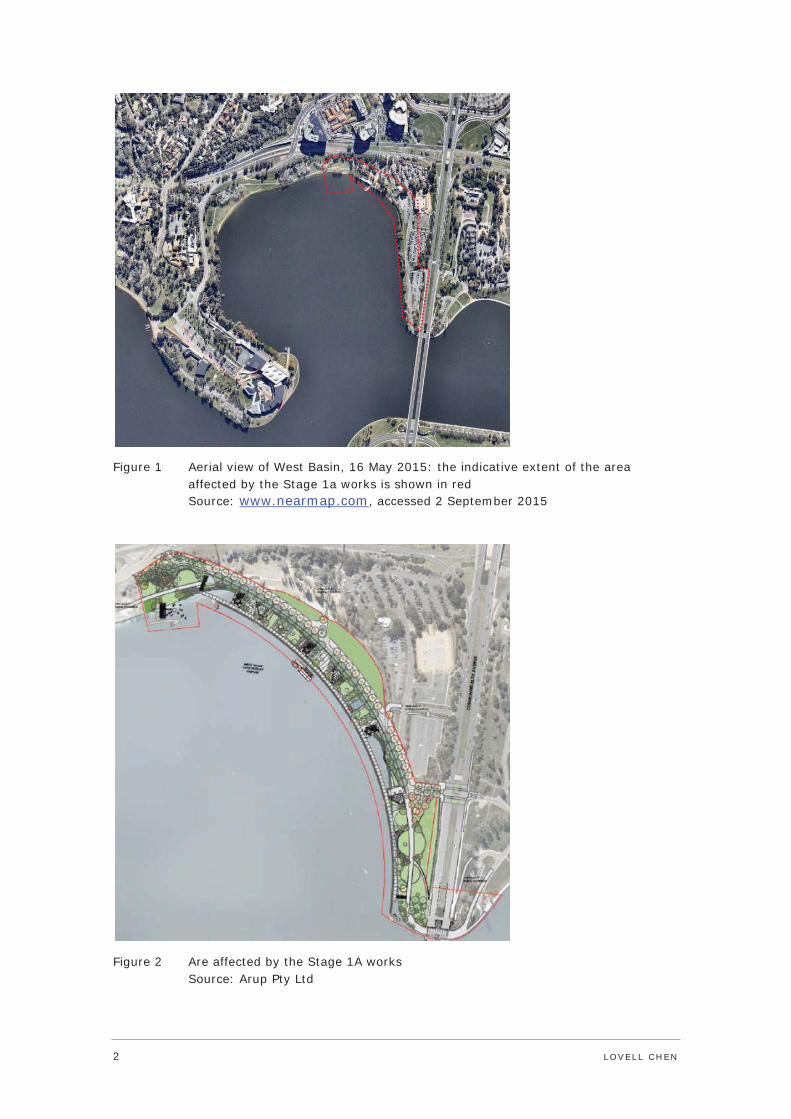
This Heritage Impact Statement (HIS) has been prepared for the Land Development Agency (LDA). It provides an assessment of impacts on European cultural heritage relating to the delivery of Stage 1A of the proposed development of the West Basin foreshore. The affected area extends from Commonwealth Avenue Bridge to the north shore of West Basin (Figure 1 and Figure 2). While this document does not address Indigenous or natural heritage issues, reference has been made to City to the Lake – West Basin Project, Stage 1 Indigenous Heritage Assessment, prepared by Cultural Heritage Management Australia, June 2014. Other key references are: Lake Burley Griffin and Adjacent Lands Heritage Management Plan, prepared by Godden Mackay Logan (2009); and National Capital Plan Amendment 61.
1.1 City to the Lake
The proposed redevelopment of West Basin as a cultural and entertainment precinct providing a mix of uses – including retail, recreation, accommodation and public open space – is part of a major urban renewal initiative, the City to the Lake project.
The underpinning principles of City to the Lake project are for the delivery of aspects of Walter Burley Griffin’s vision for an active lakefront that is integrated with Civic in a manner that meets the contemporary needs and expectations of the national capital. These principles have statutory effect in the provisions of the National Capital Plan (NCP) which was amended (in 2006) to incorporate a number of the recommendations of the Griffin Legacy. The Griffin Legacy amendments were included in the NCP following a comprehensive review and consultation process.
The Griffin Legacy was a major initiative of the National Capital Authority (NCA). The findings of the initiative were published in 2004 – The Griffin Legacy – Canberra, the Nation’s Capital in the 21st Century, NCA. The Griffin Legacy assesses the relevance of the Griffin Plan in the twenty-first century, and establishes a framework to deliver or recover elements of the Griffin Plan considered to have the potential to reinforce core values of Griffin’s vision. Critically, the Griffin Legacy reasserts the primacy of Griffin’s vision for Canberra as the primary driver in the city’s future development.
The City to the Lake project is to be delivered incrementally, as follows:
Stage 1A: West Basin foreshore from Commonwealth Bridge to the proposed Aquatics Centre . Stage 1A comprises the redevelopment and activation of this section of the waterfront as a cultural and entertainment precinct supporting a mix of uses, including retail, recreation, accommodation and public open space
Stage 1B: West Basin foreshore from the proposed Aquatics Centre to the National Museum of Australia
Stage 2: West Basin estate (the land to the south-west of Parkes Way and Commonwealth Avenue)
The balance of the City to the Lake project including City Hill
Parkes Way, including the introduction of green bridges to improve connectivity with Civic
Commonwealth Avenue1
1 Arup, Draft PSP Report for City to Lake West Basin Foreshore Works Package 2 Main Works, May 2015, p. 4.
2 LOVELL CHEN
Figure 1 Aerial view of West Basin, 16 May 2015: the indicative extent of the area affected by the Stage 1a works is shown in red Source: www.nearmap.com, accessed 2 September 2015
Figure 2 Are affected by the Stage 1A works Source: Arup Pty Ltd

LOVELL CHEN 3
1.2 City to the Lake: Stage 1 and the West Basin estate
The proposed redevelopment of West Basin is divided into three stages: Stage 1A, Stage 1B and the West Basin estate. The works for each stage are consistent with Amendment 61 to the National Capital Plan (included in the NCP at Section 1.2 and Appendix T.9). The works are also shown in the illustrative masterplan prepared by Arup, JULA, Hill Thalis, Tait Waddington and Calibre Consulting (dated 6 March 2015, Figure 3). The illustrative masterplan demonstrates intent with regard to land uses; built form outcomes (to the extent of indicative building envelopes and height); and landscape treatment, i.e. paving types and a palette of plantings.
To date, detailed design has been completed for Stage 1A of the project only. Detailed design for subsequent stages will follow, and will form the subject of separate permit applications.
The Stage 1A works have been assessed in this HIS as a standalone project, and are not reliant on the delivery of subsequent stages.
Figure 3 Illustrative masterplan for the City to the Lake project Source: Arup

4 LOVELL CHEN
1.2.1 Stage 1A
Stage 1 of the West Basin foreshore project includes land reclamation, a new lake wall and the creation of a waterfront park and promenade with associated facilities/amenities. These works are documented in the drawings listed below, prepared by Arup, JULA, Hill Thalis, Tait Waddington and Calibre Consulting. These drawings were reviewed in the preparation of this HIS.
The following drawings are dated 3 March 2015 (all Issue B):
Land reclamation and lake wall
CttL-S1AW1-MGN-DRG-0001 – Cover sheet
CttL-S1AW1-MGN-DRG-0005 – General arrangement
CttL-S1AW1-MGN-DRG-0010 – Detailed plan reclamation works
CttL-S1AW1-MGN-DRG-0011 – Detailed plan lake wall
CttL-S1AW1-MGN-DRG-0012 – Detailed plan storm water drainage
CttL-S1AW1-MGN-DRG-0015 – Reclamation sections – sheet 1 of 2
CttL-S1AW1-MGN-DRG-0016 – Reclamation sections – sheet 2 of 2
CttL-S1AW1-MGN-DRG-0020 – Typical lake wall sections
CttL-S1AW1-MGN-DRG-0025 – Lake wall elevations
CttL-S1AW1-MGN-DRG-0030 – Outfall section and details
CttL-S1AW1-MGN-DRG-0035 – Proposed typical construction sequence
The following drawings are dated May 2015 (all Revision A):
Architecture/Urban Design
CttL-S1AW2-AGN-DRG-0001
CttL-S1AW2-AGN-DRG-0020 - CttL-S1AW2-AGN-DRG-0022 (inclusive)
CttL-S1AW2-AGN-DRG-0030 - CttL-S1AW2-AGN-DRG-0036 (inclusive)
CttL-S1AW2-AGN-DRG-0040
CttL-S1AW2-LGA-DRG-0101 - CttL-S1AW2-LGA-DRG-0109 (inclusive)
Landscape
CttL-S1AW2-LLU-DRG-0010
CttL-S1AW2-LLU-DRG-0051 - CttL-S1AW2-LLU-DRG-0054 (inclusive)
CttL-S1AW2-LLU-DRG-0101 - CttL-S1AW2-LLU-DRG-1010 (inclusive)
CttL-S1AW2-LLU-DRG-1051
CttL-S1AW2-LLU-DRG-1101 - CttL-S1AW2-LLU-DRG-1109 (inclusive)
PR Engineering
CttL-S1AW2-CCW-DRG-0001
CttL-S1AW2-CCW-DRG-0010 - CttL-S1AW2-CCW-DRG-0011
CttL-S1AW2-CCW-DRG-0101 - CttL-S1AW2-CCW-DRG-0107 (inclusive)

LOVELL CHEN 5
CttL-S1AW2-CCW-DRG-0151 - CttL-S1AW2-CCW-DRG-0157 (inclusive)
Maritime
CttL-S1AW2-MCW-DRG-0010 - CttL-S1AW2-MCW-DRG-0011
CttL-S1AW2-MDI-DRG-0001
CttL-S1AW2-MGA-DRG-0005
CttL-S1AW2-MSD-DRG-0015 - CttL-S1AW2-MSD-DRG-0017 (inclusive)
CttL-S1AW2-MSD-DRG-0020
CttL-S1AW2-MSD-DRG-0025
CttL-S1AW2-MSD-DRG-0030
1.3 Statutory obligations and planning controls
1.3.1 EPBC Act
West Basin is Commonwealth owned land. As such, it is subject to the provisions of the Environment Protection and Biodiversity Conservation Act 1999 (EPBC Act).
A Heritage Management Plan (HMP) for Lake Burley Griffin and Adjacent Lands prepared by Godden Mackay Logan in 2009 found that the lake – including West Basin – satisfies the threshold for inclusion in the Commonwealth Heritage List (CHL). The HMP also found that the lake meets the threshold for inclusion in the National Heritage List (NHL). Lake Burley Griffin and Adjacent Lands is a ‘nominated’ place to the CHL.2 The current nomination of Lake Burley Griffin and Lakeshore Parklands to the NHL is ineligible (see Section 1.4).
It is also noted that Canberra itself is a nominated place to the NHL (‘Canberra - Central National Area and Inner Hills’ place ID 106100, and ‘Canberra and Surrounding Area’, place ID 106074). Both of the nominated areas include Lake Burley Griffin.
The EPBC Act requires that the management of Commonwealth owned places that have been identified as having Commonwealth and/or National heritage values is consistent with the relevant schedules of the Environment Protection and Biodiversity Conservation Act Regulations 2000. Schedule 7B, which applies to Commonwealth Heritage places, is as follows:
1. The objective in managing Commonwealth Heritage places is to identify, protect, conserve, present and transmit, to all generations, their Commonwealth Heritage values.
2. The management of Commonwealth Heritage places should use the best available knowledge, skills and standards for those places, and include ongoing technical and community input to decisions and actions that may have a significant impact on their Commonwealth Heritage values.
2 Nominated heritage places have yet to be assessed by the Australian Heritage Council. The documentation pertaining to the place is typically that provided by the nominator, and the significance or values attributed to the place are the views of the nominator. See Australian Heritage Database online, www.environment.gov.au/heritage/publications-and-resources/australian-heritage-database

6 LOVELL CHEN
3. The management of Commonwealth Heritage places should respect all heritage values of the place and seek to integrate, where appropriate, any Commonwealth, State, Territory and local government responsibilities for those places.
4. The management of Commonwealth Heritage places should ensure that their use and presentation is consistent with the conservation of their Commonwealth Heritage values.
5. The management of Commonwealth Heritage places should make timely and appropriate provision for community involvement, especially by people who:
(a) have a particular interest in, or associations with, the place; and
(b) may be affected by the management of the place;
6. Indigenous people are the primary source of information on the value of their heritage and that the active participation of indigenous people in identification, assessment and management is integral to the effective protection of indigenous heritage values.
7. The management of Commonwealth Heritage places should provide for regular monitoring, review and reporting on the conservation of Commonwealth Heritage values.
Where an action with the potential to have a significant impact on the Commonwealth values of a heritage place is proposed, the action must be referred to the Minister for the Environment for consideration. In the event that the referral is considered not to have a significant impact, the works may proceed, possibly subject to conditions. Where an action is ‘controlled’, further assessment is required before a decision can be made.
1.3.2 Lake Burley Griffin and Adjacent Lands Heritage Management (2009)
The CHL entry for Lake Burley Griffin, which is based on the Lake Burley Griffin and Adjacent Lands Heritage Management Plan (2009) prepared by Godden Mackay Logan, assesses the Lake to have a wide of heritage values, including the following Commonwealth Heritage List criteria: A (historic), B (rarity), C (scientific), D (representative), E (aesthetic), F (creative and technical), G (social) and H (associative).3 All of these values also apply to West Basin. The HMP establishes a framework for the conservation and management of the lake’s cultural heritage values. The HMP has been referred to in the preparation of this HIS.
The Summary Statement of Significance for Lake Burley Griffin and Adjacent Lands in the HMP is transcribed below:
The Lake Burley Griffin Study Area possesses outstanding creative, technical and aesthetic heritage values for the nation as a whole, which meet the threshold for National Heritage listing.
Lake Burley Griffin is an essential part of what defines Canberra. It is an essential component of the Griffin plan for a lake to link and unify the axes and vistas of the plan to the underlying landform of the place. The lake is a unique and creative aspect of Australia’s most successful urban plan, which is highly valued by communities for its aesthetic qualities.
3 Lake Burley Griffin and Adjacent Lands Heritage Management Plan, Godden Mackay Logan, 2009, p. 3.

LOVELL CHEN 7
The lake is an outstandingly successful engineering and technical achievement which underpins the success of its creative and aesthetic qualities.
The Lake Burley Griffin Study Area also possesses highly significant historical, rarity, social, representative and associative values which meet the threshold for Commonwealth Heritage listing.
The Lake Burley Griffin Study Area is important for its association with the creation of the national capital and subsequent phases of national development. It reflects two key periods of urban design: the City Beautiful/Garden City discourses, associated with the design of the lake; and the later discourses of International Modernism, associated with its construction, its edge treatments and features. The Study Area also has links to Canberra’s history including the workers of the temporary Westlake settlement and the construction of the first sewer infrastructure for the capital.
The Study Area supports habitats for threatened ecological communities and species such as: yellow box - Blakely’s red gum grassy woodland, temperate natural grasslands, the Button wrinklewort, striped legless lizard, Perunga grasshopper and the Murray Cod.
The lake is valued highly by communities for its landmark value, as a symbol of Canberra and as an iconic cultural landscape, which for many is a symbol of local identity.
The lake is associated with important individuals involved in the creative and technical aspects of the design and construction of the lake such as Walter Burley Griffin, Marion Mahony Griffin, Charles Scrivener, John Sulman, Charles Weston, Lindsay Pryor, Sir William Holford, Dame Sylvia Crowe, Richard Clough, Peter Harrison, Trevor Gibson and John Overall. Roman Cypress Hill and the Lindsay Pryor Arboretum are sites within the Study Area which are associated with the work of Griffin and Pryor.
The Study Area supports natural areas valued as remnants of the pre-settlement environment and an aquatic ecosystem which is valued by the community.
The Lake Burley Griffin Study Area possesses significant scientific research value and values as a part of Indigenous tradition, which also meet the threshold for Commonwealth Heritage listing.
The Study Area possesses research potential relating to the study of the history and development of urban design and key practitioners in this area.
The occurrence of threatened ecological communities and species also provide some opportunities for scientific research.
The Indigenous archaeological sites of the Study Area are valued highly by Indigenous communities as evidence of their traditional occupation of this

8 LOVELL CHEN
area. These sites also possess research potential for contributing to an understanding of past Indigenous lifeways in the area.4
1.3.3 Australian Capital Territory (Planning and Land Management) Act, 1988
National Capital Plan
The National Capital Authority (NCA) is responsible, on behalf of the Commonwealth, for ensuring that Canberra is planned and developed in accordance with its national significance. The National Capital Plan (NCP) establishes a framework for development and land use in the city and the ACT, and is the primary mechanism for achieving this goal.
Through its inclusion within the Central National Area, West Basin and its foreshore is a Designated Area under the NCP. Development in the Central National Area is required to have regard for the principles of the Griffin Legacy as set out in the NCP.5 Policies and principles for Lake Burley Griffin and Foreshore are at Section 1.2 of the NCP. In the case of West Basin, the provisions of Appendix T.9 to the NCP apply (see below).
The Australian Capital Territory (Planning and Land Management) Act, 1988, provides that the NCP may:
Set out the detailed conditions of planning, design and development in Designated Areas and the priorities in carrying out such planning, design and development. [See ‘Amendment 61’ below.]
The National Capital Authority (NCA) is responsible for determining detailed conditions of planning, design and development, and for works approval in Designated Areas.
Amendment 61 to the National Capital Plan
‘Amendment 61 – West Basin’ to the NCP was gazetted on 5 December 2006. It provides a statutory framework to guide the development of West Basin in accordance with the national significance of the area. The amendment is included in the NCP at Section 1.4 and Appendix T.9. Principles for West Basin are as follows:
1. Create a legible network of paths and streets that extends the city to the lake.
2. Create a vibrant public waterfront promenade in the Central National Area.
3. Enhance the range of tourism and recreation experiences available on Lake Burley Griffin.
4. Enhance continuous public access to the lake shore with links to the surrounding national attractions.
5. Provide a mix of land uses.
6. Realise key elements of the geometry and intent of the 1918 Griffin Plan at West Basin.
7. Develop a built environment which demonstrates design excellence.
8. Achieve best practice environmentally sustainable development.
Policies for West Basin are as follows:
4 Lake Burley Griffin and Adjacent Lands Heritage Management Plan, Godden Mackay Logan, 2009, pp. 2-3.
5 Consolidated National Capital Plan, as updated May 2014, pp. IX-XII.

LOVELL CHEN 9
a) Extend the city grid of streets and paths to enhance connectivity and accessibility to the lake.
b) Create a waterfront promenade involving reclamation of a part of the lake and the construction of a new lake wall.
c) Develop West Basin with a mix of uses and create a public domain which demonstrates urban design excellence.
d) Provide continuous public access around West Basin linking the Parliamentary Zone and other national attractions.
e) Contribute to the visitor and recreation experience of the Lake Burley Griffin parklands with an active water front promenade, permitting a high level of tourist, entertainment, accommodation and leisure uses.
f) Enhance Commonwealth and Edinburgh Avenues as important physical, visual and symbolic links of Canberra.
g) Reinforce Commonwealth Avenue, a significant approach route and vista to Parliament House, as a corridor of activity leading pedestrians from the city into the Parliamentary Zone.
h) Develop a significant public building, cultural attraction or landscape space on the water axis at the western shore of West Basin.
i) Implement best practice environmental design and management, including water sensitive urban design.
Amendment 61 also includes ‘Detailed Conditions of Planning Design and Development’. Matters addressed in the conditions include: guidelines for building height and form; land reclamation from the lake, to enable the construction of a waterfront promenade that reflects the geometry of the 1918 Griffin Plan; the introduction of land bridges over Parkes Way; the future character of landscape areas and streetscapes; and access. Land uses for West Basin are specified at Section 1.4 of the NCP (see Figure 4). The lake foreshore extending from Commonwealth Bridge to the approximate mid-point of West Basin (the study area) is identified as ‘Open Space/Waterfront Promenade’. Permitted land uses for the north-west foreshore of West Basin are: Cultural facility, Place of assembly, National Capital use and Waterfront promenade.6
With regard to heritage, Appendix T.9 requires the following:
Provide public access to local heritage places around West Basin.
Create a public waterfront promenade reflecting the geometry and intent of the 1918 Griffin Plan.
Provision for a pedestrian bridge linking the National Museum of Australia to the south bank of Lake Burley Griffin has been removed from Appendix T.9 (Amendment 79 to the NCP, June 2013).
6 Consolidated National Capital Plan, as updated May 2014, p. 13.

10 LOVELL CHEN
Figure 4 Land uses for West Basin: the area affected by Stage 1A is shown green Source: Section 1.4 (Figure 11) of the Consolidated National Capital Plan, September 2013, accessed online 10 February 2015
National Capital Plan: Land Use Policies
Also of relevance are the Land Use Policies in the NCP, which include the following in regards to Lake Burley Griffin:
The formal national capital character of the Lake as a key element of the Griffin Plan is to be fully expressed in the Central Basin, while East and West Basins are to respond to the architectural character of the central area.7
National Capital Plan, Heritage ‘Section 10’
Section 10 of the NCP includes the following policies relating to heritage places:
(a) Planning and development should give due protection to any natural or cultural heritage place in the ACT included on the Register of the National Estate and/or heritage register of the ACT Government.
(b) Within Designated Areas the Authority will require Conservation Plans for listed heritage places. The Conservation Plans for cultural heritage
7 Consolidated National Capital Plan, as updated May 2014, p. 43.
LOVELL CHEN 11
sites will follow the principles of the Australia ICOMOS Guidelines for the Conservation of Places of Cultural Significance (Burra Charter).
(c) Planning policies and the applicable development conditions should conform with the requirements of any such Conservation Plan.
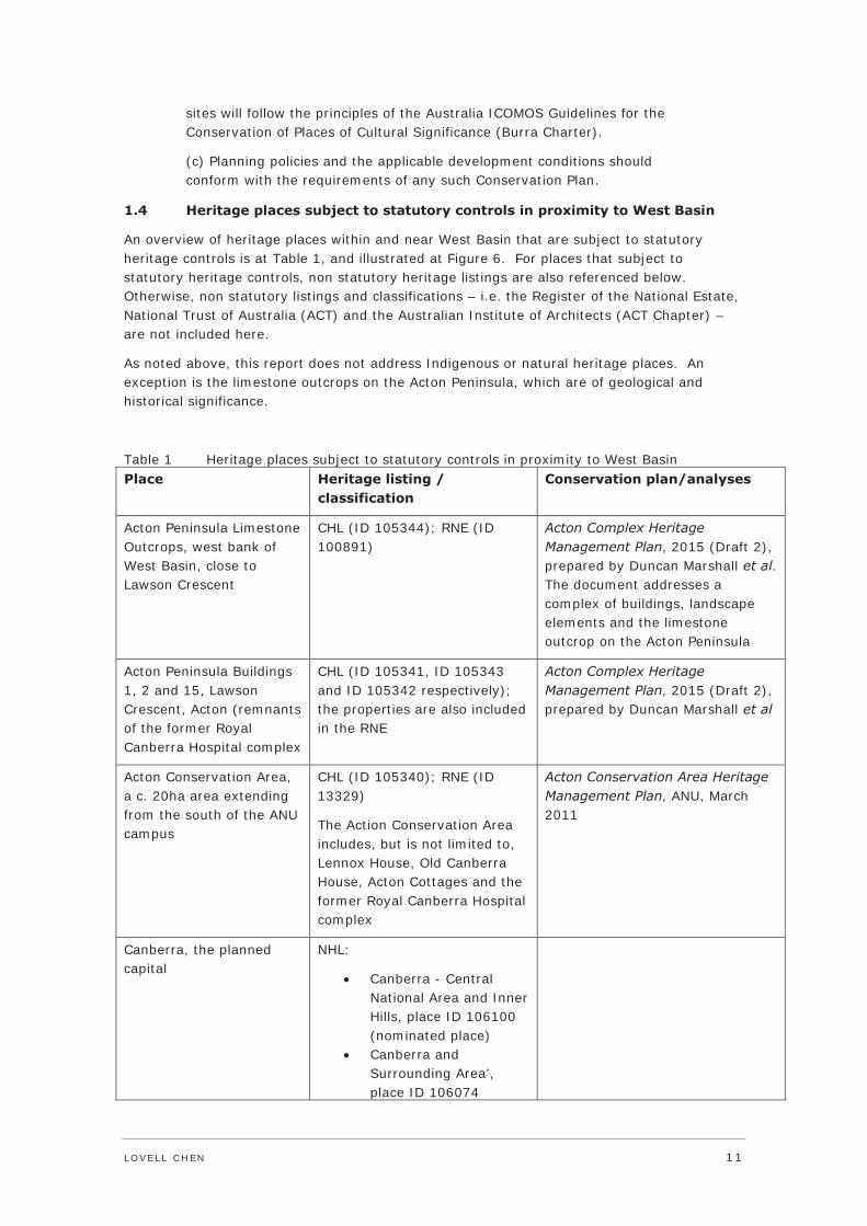
1.4 Heritage places subject to statutory controls in proximity to West Basin
An overview of heritage places within and near West Basin that are subject to statutory heritage controls is at Table 1, and illustrated at Figure 6. For places that subject to statutory heritage controls, non statutory heritage listings are also referenced below. Otherwise, non statutory listings and classifications – i.e. the Register of the National Estate, National Trust of Australia (ACT) and the Australian Institute of Architects (ACT Chapter) – are not included here.
As noted above, this report does not address Indigenous or natural heritage places. An exception is the limestone outcrops on the Acton Peninsula, which are of geological and historical significance.
Table 1 Heritage places subject to statutory controls in proximity to West Basin Place Heritage listing /
classification Conservation plan/analyses
Acton Peninsula Limestone Outcrops, west bank of West Basin, close to Lawson Crescent
CHL (ID 105344); RNE (ID 100891)
Acton Complex Heritage Management Plan, 2015 (Draft 2), prepared by Duncan Marshall et al. The document addresses a complex of buildings, landscape elements and the limestone outcrop on the Acton Peninsula
Acton Peninsula Buildings 1, 2 and 15, Lawson Crescent, Acton (remnants of the former Royal Canberra Hospital complex
CHL (ID 105341, ID 105343 and ID 105342 respectively); the properties are also included in the RNE
Acton Complex Heritage Management Plan, 2015 (Draft 2), prepared by Duncan Marshall et al
Acton Conservation Area, a c. 20ha area extending from the south of the ANU campus
CHL (ID 105340); RNE (ID 13329)
The Action Conservation Area includes, but is not limited to, Lennox House, Old Canberra House, Acton Cottages and the former Royal Canberra Hospital complex
Acton Conservation Area Heritage Management Plan, ANU, March 2011
Canberra, the planned capital
NHL:
Canberra - Central National Area and Inner Hills, place ID 106100 (nominated place)
Canberra and Surrounding Area’, place ID 106074

12 LOVELL CHEN
Place Heritage listing / classification
Conservation plan/analyses
(nominated place)
Lake Burley Griffin and Lakeshore Parklands
Lake Burley Griffin and Adjacent Lands (Nominated to the CHL, ID 105230)
Lake Burley Griffin and Lakeshore Parklands (The current nomination of the place to the NHL is ineligible – ID 106206)
The Central Basin of Lake Burley Griffin is included within the Parliament House Vista:
CHL, 105466 RNE, 13371
Lake Burley Griffin and Adjacent Lands, Heritage Management Plan, Volumes 1-4, Godden MacKay Logan (2009); Lake Burley Griffin, Heritage Assessment, Godden MacKay Logan (2009).
A Heritage Assessment of the Canberra Central Parklands (comprising Commonwealth Park, the Rond Terraces and Kings Parl) was prepared by Duncan Marshall et al in 2007.
Study of the Social Value of Lake Burley Griffin and its Setting, Shirley Pipitone, 2009
Lennox House complex, Section 34 Block 4, located with the Acton Conservation Area
CHL (ID 105307); RNE (ID 19455); ACT Heritage Register
ANU Lennox House Heritage Management Plan, ANU/ John Armes & Associates, 2009
Old Canberra House, located with the Acton Conservation Area
CHL, part of the Acton Conservation Area; National Trust of Australia (ACT), Classified Place; RNE
Australian National University Heritage Study: Volumes 1 and 2, Ratcliffe and Armes, 1993
16 Lennox Crossing, Acton, Block 4, Section 34
CHL, part of the Acton Conservation Area; ACT Heritage Register (Nominated place); National Trust of Australia (ACT) Recorded Place; Royal Australian Institute of Architects Register of Significant Twentieth Century Buildings (R112)
Conservation Plan for ANU Cottage No. 3 (16 Lennox Crossing), Freeman Collett and Partners, 1992; Australian National University Heritage Study: Volumes 1 and 2, Ratcliffe and Armes, 1993
Acton Cottages, Balmain Crescent No’s 16,18, 20, 22, 26, 28 and Liversidge Street, No’s 3, 5, 7, and 8, Section 14 Block 1
CHL, part of the Acton Conservation Area; RNE (ID 13329)
ANU Draft Acton Conservation Area Management Plan, ANU, 2011; Australian National University Heritage Study: Volumes 1 and 2, Ratcliffe and Armes, 1993
Hotel Acton, Block 1, Section 24
ACT Heritage Register; RNE (ID 100943)
Hotel Acton Conservation Management Plan, Campbell Dion Pty Ltd (2004).

LOVELL CHEN 13
1.4.1 Comment
With the exception of the Central Basin (included within the Parliament House Vista), Lake Burley Griffin is not subject to statutory heritage controls. However, as a place that has been assessed as being of Commonwealth and National significance, the protective provisions of the EPBC Act (Section 26) apply. Section 26 requires that a person must not take an action on Commonwealth land that is likely to have a significant impact on the environment, which includes heritage values.
Further, there are no heritage places subject to statutory heritage controls within the study area for Stage 1A. Heritage places in proximity to the study area are generally located to the west of West Basin (Acton Peninsula). An exception is Acton Hotel, which is located to the north of Parkes Way.
Places of potential heritage value in the immediate area which have not been subject to detailed assessment include Parkes Way and the Archbishop’s residence (Parkes, Block 1, Section 2). Parkes Way was a major intervention to the city plan overseen by eminent British planner (Sir) William Holford in the 1960s/70s. It was an expression of the post-war dominance of the motor vehicle, and was consistent with Holford’s commitment to the principles of international modernism. While it reduced the importance of Constitution Avenue (Griffin’s Municipal Axis), and created a significant barrier between Civic and the lake, Parkes Way demonstrates the layered nature of the city.
The Archbishop’s Residence was completed in 1931. In its external presentation, the single storey property demonstrates aspects of the Federal Capital style. Properties of this age and style are typically subject to heritage controls in Canberra. The Archbishop’s Residence has not previously been the subject of a heritage assessment.

14
L
OV
EL
L C
HE
N
Figu
re 5
Fi
gure
6
Her
itag
e pl
aces
sub
ject
to
stat
utor
y co
ntro
ls in
pro
xim
ity
to W
est
Bas
in
Sou
rce:
ww
w.n
earm
ap.c
om (
base
pho
togr
aph)

LO
VE
LL
CH
EN
1
5
16 LOVELL CHEN
2.0 Summary history of the study area
2.1 Pre national capital European history
European settlement in the ‘Limestone Plains’ between the 1820s and the 1910s was concentrated in the area between the St John’s Church complex and Acton Ridge. The area was contained between two river fords, one approximately south of St John’s, the other at Acton Ridge.1
The first settlement in the vicinity of the present Canberra was a stock station at Acton established in c. 1824 on behalf of John Joshua Moore, a retired lieutenant who was appointed the first Prothonotary of the Supreme Court of New South Wales in the same year. Moore’s station was established on Crown land without a permit of licence. His tenure was formalised in 1826-27, with the purchase of 400ha (1,000 acres). The construction of Moore’s homestead, ‘Canberry’ on the Acton Ridge, is believed to have commenced in 1826.
2.2 Acton as the ‘Village of Canberra’2
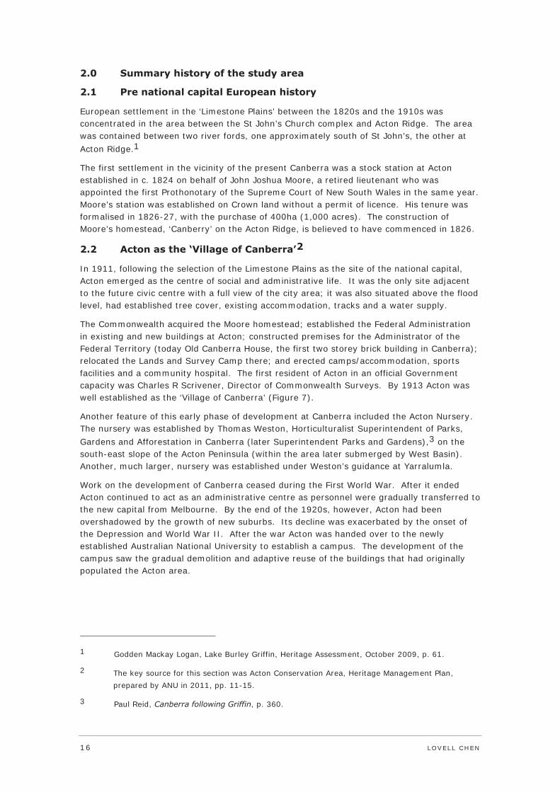
In 1911, following the selection of the Limestone Plains as the site of the national capital, Acton emerged as the centre of social and administrative life. It was the only site adjacent to the future civic centre with a full view of the city area; it was also situated above the flood level, had established tree cover, existing accommodation, tracks and a water supply.
The Commonwealth acquired the Moore homestead; established the Federal Administration in existing and new buildings at Acton; constructed premises for the Administrator of the Federal Territory (today Old Canberra House, the first two storey brick building in Canberra); relocated the Lands and Survey Camp there; and erected camps/accommodation, sports facilities and a community hospital. The first resident of Acton in an official Government capacity was Charles R Scrivener, Director of Commonwealth Surveys. By 1913 Acton was well established as the ‘Village of Canberra’ (Figure 7).
Another feature of this early phase of development at Canberra included the Acton Nursery. The nursery was established by Thomas Weston, Horticulturalist Superintendent of Parks, Gardens and Afforestation in Canberra (later Superintendent Parks and Gardens),3 on the south-east slope of the Acton Peninsula (within the area later submerged by West Basin). Another, much larger, nursery was established under Weston’s guidance at Yarralumla.
Work on the development of Canberra ceased during the First World War. After it ended Acton continued to act as an administrative centre as personnel were gradually transferred to the new capital from Melbourne. By the end of the 1920s, however, Acton had been overshadowed by the growth of new suburbs. Its decline was exacerbated by the onset of the Depression and World War II. After the war Acton was handed over to the newly established Australian National University to establish a campus. The development of the campus saw the gradual demolition and adaptive reuse of the buildings that had originally populated the Acton area.
1 Godden Mackay Logan, Lake Burley Griffin, Heritage Assessment, October 2009, p. 61.
2 The key source for this section was Acton Conservation Area, Heritage Management Plan, prepared by ANU in 2011, pp. 11-15.
3 Paul Reid, Canberra following Griffin, p. 360.

LOVELL CHEN 17
Figure 7 Plan of Acton, 1933 Source: Acton Conservation Area HMP, 2011, citing NLA 2931052)
2.3 Plans for the Federal Capital 1911-1925
The Griffins’ competition entry4
In April 1911 the Minister for Home Affairs, on behalf of the Commonwealth Government, initiated an international competition for designs for the layout of the federal capital. The 137 entries were judged by a three-man panel comprising James Alexander Smith (engineer), John Kirkpatrick (architect) and John Montgomery Coane (licensed surveyor). On 14 May 1912, two of the panel members, (Smith and Kirkpatrick) selected Walter Burley Griffin's entry as the winner. On 23 May 1912 the Minister for Home Affairs concurred with the majority decision and Griffin was awarded first prize, with entries by Eliel Saarinen (Helsinki) and Alfred Agache (Paris) placed second and third respectively.
4 Key references for the discussion of the Griffin entry and its subsequent iterations include: Paul Reid, Canberra following Griffin, A Design History of Australia’s National Capital, NAA, 2002; and An Examination of the Merits of the Nomination of the Canberra to the National Heritage List prepared by Lovell Chen for the National Capital Authority, April 2008.

18 LOVELL CHEN
It was not the Government’s intention to fully implement the winning design. Rather, the terms of the competition were that, ‘the premiated designs shall become the property of the Government for its unrestricted use, either in whole or in part.’5 Accordingly, the three winning entries, as well as the scheme placed first by Coane (prepared by Sydney practice Griffiths, Coulter and Caswell) were purchased by the Government.
The Griffin scheme – planned by Walter Burley Griffin and rendered by his wife Marion Mahony – was distinguished by an intimate relationship with the landscape (Figure 8). The central component of the proposal was an equilateral triangle (the National Triangle) whose corners were aligned on topographic outcrops or elevated land, specifically Mount Vernon in the north-west, Mount Kurrajong in the south, and the saddle between Russell Hill and Mount Pleasant in the north-east. The sides of the triangle formed the major avenues connecting the three primary centres of activity in the new city: the national government at the apex, and the municipal and market centres at the east and west of the base respectively. A series of axes provided a further organisational underpinning for the plan, specifically the Land Axis, Water Axis and the Municipal Axis.
The Land Axis formed the central alignment of the plan. The line extended from Mount Ainslie to distant Mount Bimberi via Mount Kurrajong, bisecting the central triangle and tying the city to its site. The formality and definition of this broad central axis was reinforced by the symmetrical siting of buildings at major intersections.
The Municipal Axis (Constitution Avenue) was a 3.2km (two mile) boulevard to the north of the Water Axis, connecting the east and west points of the central triangle (now Civic and Russell). This was conceived as the city’s major commercial thoroughfare, lined by commercial and residential buildings of scale. To the west of the boulevard was the Civic Centre, a hexagonal planning arrangement with City Hall surmounting Mount Vernon at its centre, and to the east was the Market Centre. Residential areas were located to the north of the Municipal Axis, and public gardens to the south, stretching down to the lakefront. Public buildings (museums, galleries and a ‘zoological garden’) were identified within the public gardens, arranged symmetrically on either side of the Land Axis.
The Water Axis (Lake Burley Griffin) followed the approximate alignment of the Molonglo River, extending from the summit of Black Mountain along the river valley towards the south-east. The Heritage Assessment of Lake Burley Griffin prepared by Godden Mackay Logan (2009) includes the following description of the three formal lake basins in the city centre:
Griffin’s design … [included] a formal central trinity of basins with circular and curved edges flanked on either side by informal lakes, the whole covering the Molonglo flood plain. The East Basin was conceived as having a higher fluctuating water level maintained by a second dam and was to act as a reservoir to maintain Central Basin levels. Another reservoir was proposed far to the east in the catchment area to be used to maintain levels and flow to the whole system. Griffin’s central triple basin was designed as the city’s heart where buildings would be reflected in the waters, while the two informal lakes either side were more for recreational use with enhanced interest from botanical gardens, arboreta and forest
5 NAA: A1818/12, Information, Conditions and Particulars for Guidance in the Preparation Competitive Designs for the Capital City of the Commonwealth of Australia, p. 4.

LOVELL CHEN 19
reserves. The plans proposed a number of central bridge crossings, the most easterly one, the Causeway, carrying a rail link.6
In addition, as noted in The Griffin Legacy document prepared by the NCA (2004):
The [Griffin] Plan provides for a number of waterfront centres, judiciously located, which allow city life to extend to the lake. These centres are urban in character and contain a relatively high density of buildings. They are served by a tram network and provide for mixed commercial and residential activity fronting broad landscaped esplanades. Tree-lined pedestrian promenades follow the water’s edge.
The balance of the lakeshores … remains overwhelmingly in favour of open space … 7
Figure 8 Detail of the Griffins’ competition entry: National Triangle Source: National Archives of Australia
Symbolically, the arrangement provided views for the ‘people’ from the public gardens over the lake to their government, with the various government departments in an ascending axis terminated by the Parliament on Camp Hill and the Capitol rising above.
6 Godden Mackay Logan, Lake Burley Griffin, Heritage Assessment, October 2009, pp. 64-65.
7 National Capital Authority, The Griffin Legacy, Canberra the Nation’s Capital in the 21st Century, 2004, p. 52.

20 LOVELL CHEN
2.4 Construction of the lake
The construction of the lake was delivered in 1962-64, by the National Capital Development Commission (NCDC), the body established under the National Capital Development Commission Act of 1957. The background to the establishment of the NCDC was a Senate Select Committee (1954-55), which was convened to ‘inquire into and report upon the development of Canberra in relation to the original plan and subsequent modifications’.8 The Committee’s report, tabled in September 1955, included 76 resolutions, including:
Resolution 60: That the examination of the question of the lakes be proceeded with immediately; and that the final decision be implemented as soon as possible; but that provision of the three central basins be regarded as obligatory.9
2.4.1 Holford’s ‘Canberra Lakes Scheme‘
A commitment to deliver the lake was reaffirmed in a 1957 report prepared by eminent British planner (Sir) William Holford, Observations on the Future Development of Canberra, ACT. Holford saw the delivery of the lake as a means of unifying the two settlements on the north and south sides of the Molonglo valley.
The following summary of investigative and implementation works for the development of Lake Burley Griffin, the two bridges and the lake shore is reproduced from Godden Mackay Logan’s Heritage Assessment of Lake Burley Griffin (October 2009):
Holford supported the lakes scheme, albeit in an altered form primarily consisting of the formal central basins with a reduced East Basin, and a reduced but still naturalistic West Lake. Holford saw the lake as a way of linking what had become a divided town. Holford’s vision included the location of the permanent Parliament House on the southern shore of the central basin.
With full responsibility for the reinstated lake vested in them, and the confidence of the Prime Minister in Canberra as the nation’s capital, the NCDC planning team proceeded to execute the Canberra Lakes Scheme with speed … The plan for the Canberra Lakes once again restored West Basin to its larger size [it had been deleted in 1926].
The NCDC followed a three-stage process for the Canberra Lakes Scheme. Firstly, there was investigation work. In 1959 contracts were let for the lake dam and work commenced on the lake bridges to provide a much-needed modern road system. A river/lakes hydraulic model was constructed to test water flows and assess the need to control weeds, algae and mosquitoes. The model suggested the need for islands in parts of the lake to direct water flows, while weeds and insect pests were to be controlled by maintaining a minimum depth of seven feet and appropriate treatment of lake edges. Investigations were made into the geological structure of the lake basins and on weir structures. Soil conservation and
8 Paul Reid, Canberra following Griffin, A Design History of Australia’s National Capital, NAA, 2002, p. 223, citing Australia, Senate, Parliamentary Debates, 3 November 1954, p. 1188.
9 Paul Reid, Canberra following Griffin, A Design History of Australia’s National Capital, NAA, 2002, p. 231.

LOVELL CHEN 21
lake water catchment programs were commenced to avoid silting of the lakebed and discolouration of its waters …
The second stage of the lake project was to shape the results of the initial investigations and have the finalised plans formally accepted. The active political support of Prime Minister Robert Menzies was instrumental in silencing opposition and ensuring that the construction of the lake would occur after decades of doubts and delays.
The third stage was the actual construction where the main agencies involved in the work were William Holford and Associates, Guy Maunsell and Partners, Rankine and Hill (advisors on West Lake) and the Commonwealth Department of Works. William Holford, as part of his firm, provided advice in relation to landscape development in the Central Basins area. His vision did not adhere to Griffin’s geometric regularities but towards producing a more naturalistic line. Holford’s plans, based on hydraulic flows in the proposed lake, advocated an informal north bank contrasting with a formal straight-sided south bank, similar to Griffin’s but with sides splaying back to each bridge. The Central Park, now known as Commonwealth Park, was designed to show off autumn and spring displays of exotic plantings. The Acton area with its hospital buildings was to act as a prominent feature, and as many poplars and other mature trees as possible were to be retained in West Basin. The Parks and Gardens section of the Department of the Interior commenced planting [on] higher ground on the lake margins, especially near Russell, according to this plan.10
The lake reached its full height on 29 April 1964.
2.5 West Basin: construction, development landscaping
Earthworks for the lake were extensive, to optimise hydraulic efficiencies and create the desired lake form. A significant volume of topsoil was removed in 1962-63, part of which was used to create islands to direct water flows; half a million cubic yards of topsoil were removed from West Lake, for use around Canberra and a stockpile for future use.11 By 1963 the Molonglo Valley was a scarred landscape (Figure 9). At West Basin, it is likely that the extensive ground disturbance resulted in the removal of evidence associated with the Weston arboretum and the Acton Peninsula sports and recreation facilities (see Figure 7). There remains some potential that evidence of limestone outcrops/caves on the east of the Acton ridge may have survived the earthworks. If revealed, these remnants would have cultural/archaeological potential.12
As noted above, a key departure from Griffin’s vision for the lake was the naturalistic foreshore, which was largely left to follow the natural contours. Within the three central basins, only the south bank of the Central Basin and the Rond Terrace (on the north shore) had a hard edge. The balance lacked the formal geometry of the Griffin plan.
10 Godden Mackay Logan, Lake Burley Griffin Heritage Assessment (Final Report), October 2009, pp. 69-70.
11 Godden Mackay Logan, Lake Burley Griffin Heritage Assessment (Final Report), October 2009, p. 70.
12 Cultural Heritage Management Australia, City to the Lake – West Basin Project, Stage 1 Indigenous Heritage Assessment, June 2014, p. 38.

22 LOVELL CHEN
West Basin, once filled, approximated the shape of a horseshoe (Figure 10), with a gravel pathway introduced on the lake edge (Figure 11). Historic photography indicates that few existing trees were maintained; the main grouping being to the north-east of the boathouse, which was built by 1968 (Figure 10). The species of these trees is indiscernible from the photographs – possibly poplars.
New plantings were introduced at the West Basin foreshore by the late 1960s, or early 1970s (Figure 12 and Figure 14), and the arrangement appears to have followed the principles of the NCDC landscape plan of 1961 (Figure 13). As noted by Duncan Marshall et al (2007): ‘The 1961 plan ... indicated vegetation as informal drifts in an attempt to integrate with the informal indigenous landscape character of the mounts and slopes to the north’.13
Based on review of historic images, and analysis of the existing landscape, the treatment of the foreshore included groupings of white poplars, Lombardy poplars and willows at the lake edge and some eucalypts at the north, near Parkes Way and Lawson Crescent.14 There were gaps between the plantations, and large open areas of grass, suggesting a semi-naturalised landscape. The approach was consistent with the recommendations for the landscaping of Lake Burley Griffin prepared by landscape architect Richard Clough (who joined the NCDC in 1964) and John Gray. These included the following:
[the] character of the natural landscape should be maintained
[the] existing colour of the landscape (brown-grey) should predominate but light fresh green should be used around the lake margins and darker conifers for boundaries and backgrounds; and
Autumn colours should be fully exploited for the formal and dramatic parts of the landscape; flowing trees and shrubs should be massed in small enclosures.15
The 1961 landscape plan also indicated three built elements for the West Basin foreshore: University steps at the intersection of the water axis with Acton Peninsula, a boathouse and a ‘conference hotel’. Of these, only the boathouse was built, on a site to the east of the location indicated on the 1961 plan. This was consistent with the intended use of West Basin as a venue for recreation, primarily water sports.
13 Duncan Marshall et al, Heritage Assessment of the Canberra Central Parklands, prepared for the NCA, February 2007, p. 56.
14 Aboricultural advice was provided by John Patrick Pty Ltd, Melbourne, March 2015.
15 Transcribed from Godden Mackay Logan, Lake Burley Griffin Heritage Assessment (Final Report), October 2009, p. 24.

LOVELL CHEN 23
Figure 9 Preparatory works for West Basin, c. 1963, looking south-east towards Commonwealth Gardens Source: National Library of Australia (Richard Clough)
Figure 10 Oblique aerial, 1964, looking south-east, showing West Basin fully filled: a grouping of retained trees is indicated Source: National Library of Australia (Richard Clough)
Figure 11 West Basin filling, 1964: view from the west shore, looking south-east towards Commonwealth Avenue Bridge Source: National Library of Australia (Richard Clough)

24 LOVELL CHEN
The grassed amphitheatre extending from Acton Hotel to the lake’s edge was cut through by Parkes Way in the mid 1970s. This transformed the scale, character and accessibility of the West Basin foreshore, which became a comparatively narrow strip of land reached by a pedestrian bridge extending from Marcus Clarke Street. By the mid 1990s, part of this area – at the south-west of the intersection between Commonwealth Avenue and Parkes Way – had been given over to at grade car parking, and trees had been introduced to the south of Parkes Way, to soften the interface with the arterial road. The basin edge had also been modified by the mid 1990s, with the loss of the regular ‘horse shoe’ shape, and the gravel pathway (Figure 15). The reasons for this change, which resulted in an appreciable change to the northern part of the foreshore as delivered by the NCDC, were not established during research for this report.
Figure 12 Aerial view of West Basin, 1968: note construction of boat shed near the grouping of plantings, and the absence of new plantings Source: ACTPLA Library

LOVELL CHEN 25
Figure 13 NCDC landscaping plan for West Basin, 1961 Source: Reproduced from Paul Reid, 2002, p. 272
Figure 14 Aerial view of West Basin, 1975: note new plantings Source: ACTPLA Library

26 LOVELL CHEN
Figure 15 Aerial view of West Basin, 1995: note the introduction of Parkes Way and the modified alignment of the northern foreshore Source: ACTPLA Library
3.0 Description of the study area
3.1 Setting
West Basin and its foreshore form part of the Molonglo River valley. The land slopes up from the lake to Civic in the north. The Basin is part of a designed urban landscape as conceived by Walter Burley Griffin in 1911. It is adjacent to the National Triangle (to the north-west), the central component of Griffin’s entry in the competition for the design of the Federal Capital. West Basin is the westernmost of a central trinity of ‘ornamental waters’ in the heart of the city. The three central basins form part of Lake Burley Griffin, a water body with an area of 664ha and a foreshore 40.5km long.16
The area also incorporates pre national capital remnants (see discussion of the Acton Peninsula below, and at Section 2.2), and later layers of development, principally associated with the NCDC. The NCDC influence is evident in the informal character of the West Basin foreshore, which moved away from Griffin’s vision for a geometric treatment, and Parkes Way to the north, which was part of a major network of arterial roads through central Canberra established in the 1960s/70s.
16 Godden Mackay Logan, Lake Burley Griffin Heritage Assessment (Final Report), October 2009, p. 11.

LOVELL CHEN 27
West Basin is enclosed to the west by the Acton Peninsula, a place of cultural significance as the centre of Canberra‘s public and social life in the period from 1911, and geological and historical significance for its limestone outcrop, an isolated exposure of the rock formation that attracted European settlers to the area from the 1820s. To the north, West Basin is framed by Parkes Way and Lawson Crescent; the recent high rise ‘Nishi’ tower at New Acton is a prominent presence to the north of Parkes Way (see Figure 17 and Figure 18). New Acton is a contemporary development that occupies much of the former Hotel Acton, an inter-war hostel that is included in the ACT Heritage Register (Figure 19). Commonwealth Avenue Bridge defines West Basin to the east.
The National Museum of Australia (2001), located on the site of the former Canberra Hospital (built 1940s, and demolished in 1997) is a major architectural feature on the southern tip of the Peninsula. The Museum, designed by Ashton Raggat McDougall and Robert Peck von Hartel Trethowan, is a complex arrangement, evoking a series of knots and loops – the intent is to reference the multiple stories of Australia and Australians. The centrepiece is a large orange loop – the Uluru Axis.
There are expansive views from the north bank of West Basin to the National Centre in the south (Figure 16). Views from the south are framed by the ring of vegetated hills and ridges that provide such a strong and distinctive setting for Canberra (Figure 17).
Figure 16 Looking south-east from the West Basin foreshore: note Commonwealth Avenue Bridge in centre (August 2012)

28 LOVELL CHEN
Figure 17 Looking north-west over West Basin from Commonwealth Bridge Avenue: the Nishi development is indicated (January 2015)
Figure 18 Looking east from the north-west foreshore of West Basin (August 2012): note Nishi development under construction
Figure 19 Recent development at New Acton (January 2015)

LOVELL CHEN 29
3.2 Study area for Stage 1A
The study area for Stage 1A comprises: an informal landscape treatment dating to the late 1960s and early 1970s; areas of open grassland; a boathouse (c. 1968) located on the lake foreshore; areas of hard paving; and a network of roads and pathways.
3.2.1 Landscape character
The foreshore has an informal, semi naturalistic character that is consistent with the NCDC landscape plan of 1961 (Figure 20, Figure 21 and Figure 22), and the recommendations for lakeshore planting prepared by Richard Clough and John Gray in 1964. The principal characteristics of the foreshore landscape are open, grassed areas, interspersed with a combination of typical northern hemisphere waterfront plantings, including willows (possibly including Salix Fragilis) and poplars (including Populus alba and Populus nigra Italica), intermingled with indigenous plantings (eucalypts).
A network of formal and informal cycle and pedestrian paths cuts through the space. As noted above, pedestrian access to the West Basin foreshore is via a pedestrian bridge from the southern end of Marcus Clarke Street, and vehicular access is via a road that crosses under Commonwealth Avenue Bridge to the south.
3.2.2 Foreshore treatment
There are areas of soft and hard edging to the West Basin foreshore, with the majority being soft, including beaches. There are areas of hard edging around the National Museum of Australia and close to the base of the Commonwealth Avenue Bridge.
3.2.3 Boathouse
The boathouse is a small two-level stone structure with a flat roof (Figure 23). A timber pontoon projects into the lake. The boathouse was completed by 1968, and was the only built outcome of a suite of elements indicated on the NCDC landscape plan of 1961.
Detailed research into the boathouse was not undertaken for this Heritage Impact Statement.
Figure 20 Looking west from close to the boathouse (August 2012)

30 LOVELL CHEN
Figure 21 Looking east from the boathouse (January 2015)
Figure 22 The north foreshore of West Basin (January 2015)
Figure 23 Left and right: Views of the boathouse (August 2012)

LOVELL CHEN 31
4.0 Proposed works
The Stage 1A works proposed for the West Basin foreshore include land reclamation and engineering works (including a new lake wall) as follows:
Reclamation of an area of West Basin (c. 25,000sqm) extending from the north-east foreshore, and using engineering fill material
Extending the existing storm water infrastructure to the new lake edge with new lake outfall
Construction of a permanent new lake wall, comprising approximately 425m of precast L reinforced concrete retaining wall structure
Demolition of the c. 1968 boathouse, and tree removal
The proposal also provides for a waterfront park and promenade comprising approximately 300m of boardwalk structure, and approximately 350m of suspended deck boardwalk structure which will provide new recreational boating facilities. The works include a new boulevard and pathway system, two park areas, low-scale pavilions (cafe and dining) and landscaping to provide new public facilities and amenities.
Boardwalk
The boardwalk is a concrete slab and panel structure which will extend along the majority of the study area, part on reclaimed land (following the alignment of the lake wall which formed part of the Stage 1a early works package – see Appendix A), and part as a suspended deck structure supported on octagonal concrete piles. The piles will be regularly spaced at approximately 6.8m apart. The total width of the proposed boardwalk will be approximately 8.1m and will be finished with precast concrete plank panels, approximately 2.7m wide and a precast concrete slab, approximately 5.4m wide. A variety of metal, timber and concrete seats and benches will be provided along the length of the boardwalk. The boardwalk will introduce a geometric form to the north-east side of West Basin and provide recreational public boating facilities.
A recreational boat hire facility is proposed at the northern end of the boardwalk, and a ferry wharf is proposed at the approximate mid-point of the works area. These facilities will each comprise vessel mooring and a waiting area/concession building. These are single-storey pavilion structures, rectangular on plan, with flat roofs. The materials palette includes expressed steel framing, timber slats fixed horizontally and large areas of glazing.
Also provided along the boardwalk are a number of circular viewing pontoons.
Foreshore development
Adjacent to the proposed boardwalk along the reclaimed land will be a number of pavilions and shade structures interspersed with areas of landscaping, feature areas (including water play, BBQs etc) and paving. The pavilions/shade structures will be variously single and two-storey, rectangular and triangular in form and generally with flat roofs.
Set back from the proposed boardwalk and lakeshore treatment is ‘Waterfront Boulevard’ which generally aligns with the proposed boardwalk at its northern end and extends east to connect with Commonwealth Avenue at the southern end. It will be variously concrete and bluestone paved with street trees interspersed along the length of the boulevard. The street trees will generally be eucalypt, oak and poplar species.

32 LOVELL CHEN
At the northern and southern ends of the study area will be two open park areas. Western Park at the northern end of the study area will be part open grassed area and part planted, with a (stepped) pathway system and play and BBQ areas. Planting in this area will include a variety of eucalypt species, with a small number of Cherry Plum and Golden Rain Tree species surrounding the proposed play area. Point Park at the southern end will be part planted and include an open grassed area. Planting in this area will include a variety of eucalypt, oak, elm and crab apple species.
5.0 Assessment of heritage impacts
The following assessment of heritage impacts has regard for:
the assessed values of West Basin;
the relevant policies and recommendations included in the Lake Burley Griffin and Adjacent Lands Heritage Management Plan prepared by Godden Mackay Logan in 2009 for the National Capital Authority; and
provisions and policies of the National Capital Plan (Amendment 61).
It is noted that the proposed Stage 1A works are generally consistent with the expectations of the National Capital Plan.
5.1 Summary of significance
5.1.1 Lake Burley Griffin and its foreshore areas
Lake Burley Griffin and its foreshore areas have been assessed as having a wide range of heritage values, specifically: historic, rarity, scientific, representative, aesthetic, creative/technical, social and associative values.
The lake and its foreshore is a central and unifying component of Walter Burley Griffin’s plan for Canberra. It also constitutes Griffin’s water axis. The use and operation of the lake is largely as intended by Griffin; it is a place for recreation and reflection. The lake is valued by the community for these uses, and for its aesthetic qualities.
Lake Burley Griffin is also valued as a cultural landscape. While it is clearly recognisable as intended by Griffin, it is an evolved place, demonstrating the influence of evolving priorities and aesthetic preferences over a sustained period. Of the latter, two trends are prominent: the City Beautiful movement and International Modernism. While landscape character, edge treatments (hard and soft) and access to the lake vary, overall it is a balanced and integrated system of open space.
The character of Lake Burley Griffin as a landscape shaped by a range of forces and influences was summarised as follows by Godden Mackay Logan in its 2009 Heritage Assessment of Lake Burley Griffin:
This is not a landscape which has evolved organically through the ebbs and flows of history, but through a dynamic intellectual process which has both shaped, and been shaped by, changing perceptions of what the Australian nation is now or should become in the future. The highly intellectual and aspirational character of this landscape has indeed incorporated and responded to the environment and society within which it is sited.17
17 Godden Mackay Logan, Lake Burley Griffin Heritage Assessment (Final Report), October 2009, p. 31.

LOVELL CHEN 33
5.1.2 West Basin
The heritage values that apply to Lake Burley Griffin also apply to West Basin (i.e. see Section 1.3.1).
Griffin anticipated West Basin and its foreshore as a place of culture and recreation. It was conceived as one of three central basins, each with a rigid geometric form. The Basin was connected to Civic, bringing the city to the lake. Parkes Way (1970s) created a barrier between the two and resulted in a significant truncation of the foreshore area. The form of the shoreline had been modified by at least the mid 1990s.
As is the case for the Lake Burley Griffin, West Basin and its setting is a layered landscape. It includes pre national capital remnants, and elements/characteristics that were not anticipated by Walter Burley Griffin.
5.1.3 Comment
From a heritage perspective the principal issues with regard to the proposed Stage 1A works are considered to be:
Land reclamation and the establishment of a hard edge to part of the West Basin foreshore approximating the geometry of the 1918 Griffin plan
5.2 Assessment
The following considers the proposed works against the relevant policies in the Lake Burley Griffin and Adjacent Lands HMP. The overarching intent of the HMP is to conserve the identified heritage values of the Lake and its foreshore areas. The HMP also promotes an holistic approach to the management of the study area as a cultural landscape.
Policy Comment
(Policy 1.4) ‘All planning or strategic documents or proposals with the potential to affect the Study Area should refer to this HMP for primary guidance on the management of its heritage values’.
Actions for the delivery of this policy include:
- ‘The promotion of] a holistic management approach to the Study Area by ensuring that proposals are assessed in terms of their potential to impact on the heritage values of the Study Area as a whole ...’
Lake Burley Griffin and its foreshore is valued as a central component of the designed, symbolic landscape of the National Capital. It has been assessed as being of historic, social and aesthetic value to the nation.
While access, edge treatments and landscape character vary, in general, it operates as intended by Griffin, as a place for recreation and reflection with an (almost) continuous landscape treatment. The Lake and foreshore is also valued as a cultural landscape that demonstrates multiple strands of influence, including Griffin’s vision (as inspired by the City Beautiful movement) and International Modernism.
Interventions with the potential to diminish these values include alterations to the overall form and shape of the Lake, significant changes its setting and large scale breaks in the generally continuous landscape treatment to the foreshore.
The works proposed for Stage 1A of the development of West Basin will result in the demolition of the c. 1968 boathouse, and the reconfiguration of part of the West Basin foreshore. They will also result in the introduction of a hard edge to the affected area. The shape of the proposed foreshore is inspired by Griffin’s vision for a

34 LOVELL CHEN
Policy Comment
rigid geometry for West Basin.
The boathouse was the only built outcome at West Basin of the NCDC landscape plan of 1961. It provided public access to the lake by means of boat hire. It is a small structure of limited architectural pretension and presence. It has not been identified as a building of heritage significance, and research undertaken for this HIS has not revealed information that would suggest that it is a place of cultural heritage significance. As indicated in the architectural drawings, the function of the boathouse will be replicated in approximately the same location (‘boat pavilion’).
The lake wall and reclamation works will provide a platform for development of West Basin as a waterfront park and promenade. The works will result in a localised interpretation of Griffin’s intent tailored to suit contemporary needs. In this sense, they can be seen as part of a continuum, where Lake Burley Griffin and its foreshore areas have been shaped by dynamic intellectual processes, and social, economic and environmental considerations.
From a heritage perspective, a key question that arises in relation to Policy 1.4 is whether the proposed treatment of the lakeshore to the north-east of West Basin (soft and hard landscaping and new built form) will diminish the historic, social and aesthetic values of Lake Burley Griffin, as identified in the HMP.
In response to this question it is considered that landscape and built outcomes are of a character and scale that will sit comfortably in the context of West Basin and the evolved lakeshore generally. It is also noted that the works will result in the activation of West Basin (part) as a place of recreation.
(Policy 1.5) ‘Co-ordinate the heritage management of the Study Area with the heritage management plans for places and landscapes which have an integral relationship with the heritage values of the Study Area.’ &
(Policy C6 – 1.1) Ensure all proposals for development around West Basin are developed in sympathy with the identified heritage values of the place and that the significance of their potential impacts on
There are a number of heritage places within and in proximity to Lake Burley and its foreshore. In the context of West Basin, these are primarily located on the Acton Peninsula. These places, in general, have an association with Acton’s emergence as the centre of public and social life in Canberra from c. 1911 to the mid twentieth century. Also of note on the Acton Peninsula are the limestone outcrops, an exposure of the rock formation that attracted European settlers to the area from the 1820s.
There are no heritage places subject to statutory controls within the area affected by the proposed Stage 1A works. Hotel Acton, located to the north of Parkes Way, is the heritage place closest to West Basin.

LOVELL CHEN 35
Policy Comment
heritage values are assessed, in line with the EPBC Act.
Hotel Acton is a component of a precinct of early Canberra buildings located to the west of Civic, including Ian Potter House, Becker House, the National Film and Sound Archive and the Shine Dome.18 As noted in the 2004 CMP for the property, ‘The construction of Parkes Way in the 1970s severed the always tenuous links between Hotel Acton and the vacant land to the south [the West Basin foreshore]’.19
In recent years, Hotel Acton has suffered a major fire and undergone a significant redevelopment. The primary heritage value of the Acton Hotel today is historical. A view line from the retained low scale pavilions at the south of the Hotel Acton site has been retained, providing some visual connectivity to the land to the south. Development to the south as an outcome of the West Basin redevelopment is anticipated to include 25m-high development on the south side of Parkes Way, and the land bridges over Parkes Way itself. As such, the setting for the Hotel will undergo further change. However, the core value of the place (historical) will not be impacted.
The Stage 1A works will alter the presentation of part of the West Basin foreshore but will not impact on the identified heritage values of West Basin or Lake Burley Griffin as a whole. The historic association of Lake Burley Griffin with the creation of the national capital and subsequent phases of development will remain extant and the lake generally and West Basin foreshore specifically will retain their current uses and associations, views and vistas and essential aesthetic characteristics.
(Policy 1.6) ‘Conserve and manage the integrity of the formal design elements of the study area that derive from the Griffin plan and the later design and construction of the lake and its foreshores, influenced by Holford and the NCDC.’ &
(Policy C6-1.4) ‘Ensure foreshore development enhances and contributes to the reflective qualities of the lake setting and provides plantings designed to contribute to the lake’s
Formal design elements that relate to the Griffin plan include the location of Lake Burley Griffin on the Water Axis (Molonglo Valley); its connection to its setting (ring of vegetated hills); the landscaped character of the foreshore areas; and views and vistas across the lake. A major variation in the Lake as delivered by the NCDC was the naturalistic form of the shoreline.
The new built form proposed includes pavilions and shade structures which are variously one and two-storey, rectangular and triangular in form and generally with flat roofs. These structures will be sited as locations along the length of the study area separated by areas of pathways and landscaping. The proposed new buildings are modest in height and scale and will accommodate amenities necessary to support the redevelopment and
18 Hotel Acton Conservation Management Plan, Campbell Dion Pty Ltd, 2004, p. 7.
19 Hotel Acton Conservation Management Plan, Campbell Dion Pty Ltd, 2004, p. 7.

36 LOVELL CHEN
Policy Comment
character.’ &
(Policy C6-1.5) ‘Retain the sense of the lake and its surrounding developments as located in an open park-like setting.’
activation of the West Basin foreshore. The buildings will present as contemporary additions along the foreshore but will not dominate the foreshore or impede or obscure views to the foreshore from the surrounding areas including from the north and east or from the West Basin foreshore outside of the study area (to the west).
With regard to landscaping, wholesale tree removal is proposed, and the delivery of areas of hard and soft landscaping comprising two parks at the northern and southern ends of the study area as well as areas of landscaping interspersed throughout.
The existing landscape character at West Basin was introduced in the late 1960s/early 1970s by the NCDC. The trees to the lake edge are a combination of deciduous and evergreen species. The landscape has an informal, semi naturalistic quality. It lacks the distinction, formality and ceremonial associations of the parklands to the Central Basin and King’s Park.
New plantings in the proposed park and landscape areas will include shrubs, groundcover and various tree species including eucalypts, oaks, elms and crab apples. These works will contribute to and enhance the landscape character of Lake Burley Griffin and maintain an open park-like setting along the West Basin foreshore.
The Stage 1A works (hard and soft landscaping, and low-scale development) will conserve the integrity of the formal design elements that relate to the Griffin plan. The informality associated with the NCDC works will remain evident in large areas of the lake foreshore, including the north-west shore of West Basin.
(Policy 1.7) ‘Recognise the Lake Burley Griffin study area as a layered cultural landscape, the heritage values of which reflect Indigenous use and cultural values; early European use and development; the Griffin plan; the Holford plan and subsequent phases of design and construction by the NCDC; and the remnant natural environment.’
Actions for the delivery of this policy include:
- ‘[Conserving] the diverse landscape character of the Study
Lake Burley Griffin and its foreshore is a complex and multi layered landscape. In the context of West Basin, evidence of pre-national capital land use and associations include the Acton limestone outcrops. Elements associated with early life in Canberra (some pre-dating Griffin’s association with the city) are contained within the Acton Peninsula. As noted, Parkes Way, and the naturalistic shoreline of the lake, are legacies of the NCDC’s influence.
Implications for the layering of the landscape arising from the works proposed for Stage 1A include archaeological remnants associated with the tenure of Acton Peninsula as the centre of political and social life in Canberra. As noted at Section 2.2, the Weston arboretum and recreational facilities were located in the area flooded to create West Basin. It is probable that evidence of these activities was removed by the extensive earthworks undertaken for the creation of the lake. There remains

LOVELL CHEN 37
Policy Comment
Area, including the contrasts between the formal and informal landscapes, and native and exotic vegetation.’
- ‘[Conserving] the overall form and shape of the lake which strongly reflects the Griffin plan.’
- ‘[Conserving] the islands and areas of hard and soft edge treatments reflecting the period of design and construction of the lake.’
some potential that limestone caves/outcrops that were submerged during the creation of the lake survive in the vicinity of the east side of the Acton ridge. This area is not affected by the works for Stage 1A. In the event that an artefact or other sub-surface material of potential significance comes to light, the NCA should be notified of the discovery.
The Stage 1A works and the works set out in the illustrative masterplan respond to Amendment 61 to the NCP, which gives weight to aspects of Griffin’s vision for Canberra. Delivery of the works and the masterplan will result in a recalibration of the character and identity of West Basin, whereby the Griffin ‘layer’ will have greater prominence than is currently the case. However, in the context of the lake at large, these works will have a very marginal impact on the balance of the layered cultural landscape.
(Policy C6-1.3) ‘Conserve and manage significant views and solar access to the foreshore by managing the height of foreshore development to provide views and to prevent overshadowing of the foreshore.’
There will be no substantive impact on view corridors to and from the lake as a result of the proposed works. The works will alter the presentation of this section of the foreshore and introduce new low-scale built form within the study area but will not impede or obscure views to West Basin or along the foreshore from the surrounding area.
(Policy 1.8) ‘Conserve and manage the aesthetic values of the Study Area which are particularly valued by the community.’
As noted in the Heritage Assessment of Lake Burley Griffin (GML, 2009), Lake Burley Griffin is valued by the Canberra community for its aesthetic qualities and social and cultural meanings:
Evidence of emotional response to the lake itself is expressed in a range of ways. Descriptive language such as ‘majestic’, ‘spectacular’ and ‘breathtaking’ emphasises the response to visual qualities, including the presence of water within the city and the form and setting of the lake. Similar responses to formality and symmetry were expressed through the siting and design of the lake – particularly the Central Basin and land/water axis – and in an appreciation of the sense of ‘unity’ the lake brings to Canberra. The natural character of the lake provides for communities a sense of wildness and remoteness, bringing ‘peaceful’ experience to living in Canberra. The integration of the built and natural landscape and the aesthetic response

38 LOVELL CHEN
Policy Comment
evoked by this is evident as deeply embedded in what it means to live in Canberra. The ‘light, colour and movement’ of Lake Burley Griffin was described as ‘the heart of Canberra’. An understanding of the lake and its surrounds as part of continuing living ecosystems, providing habitat for valued flora and fauna, further evokes a sense of response to the place.20
The qualities and attributes that underpin these sentiments will not be materially affected by the proposed Stage 1A works.
Further, the proposed works will not impact on the aesthetic values of the lake which will retain its role as a unifying element of the city with a landscaped and accessible lakeshore, as conceived by Griffin and delivered by the NCDC.
5.3 Concluding comments
The Stage 1A works as proposed are generally consistent with the principles and policies of the National Capital Plan and the relevant policies in the Lake Burley Griffin and Adjacent Lands Heritage Management Plan.
The works will result in a hybrid quality at West Basin, with evidence of the Griffin intent for Canberra being more pronounced than is currently the case. This outcome is anticipated by the Griffin Legacy amendment to the NCP. Considered in the context of Lake Burley Griffin, the Stage 1A works will result in a marginal impact on the balance of the lake and its foreshore as layered cultural landscape.
While the proposal will alter the presentation of part of the West Basin foreshore, the works will not impact on the identified heritage values of West Basin or Lake Burley Griffin as a whole. The historic association of Lake Burley Griffin with the creation of the national capital and subsequent phases of development will remain extant, and the lake generally and West Basin foreshore specifically will retain their current uses and associations, views and vistas and essential aesthetic characteristics.
20 Godden Mackay Logan, Lake Burley Griffin Heritage Assessment (Final Report), October 2009, p. 137.