A groundwater vulnerability assessment of the Korgen ...
3
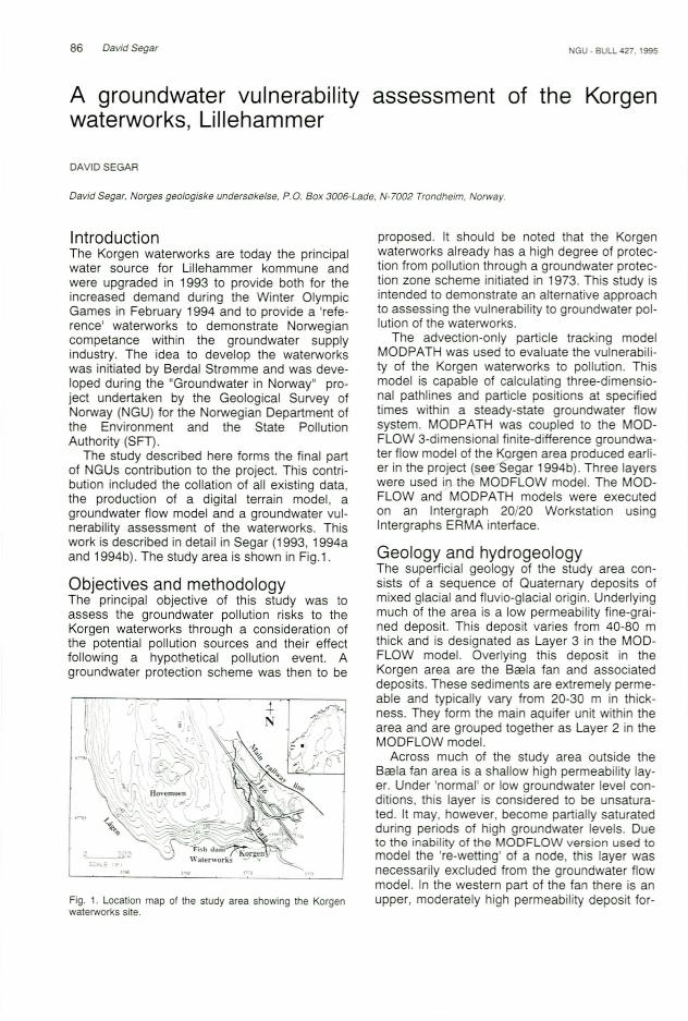
86 David Segar GU . BULL 427. 1995 A groundwater vulnerabi l ity assessment of the Korgen waterworks , Li llehammer DAVIDSEGAR David Segar , Norges geologiske uruierso ketse, p.a. Box 3006-Lade, N-7002 Trondheim, Norway. Introduction The Korgen waterworks are today the principal water source for Lillehammer kommune and were upgraded in 1993 to provide both for the increased demand during the Winter Olympic Games in February 1994 and to provide a 'refe- rence' waterworks to demonstrate Norwegian competance within the groundwater supply industry. The idea to develop the waterworks was initiated by Berdal Stromme and was deve- loped during the "Groundwater in Norway" pro- ject undertaken by the Geological Survey of Norway (NGU) for the Norwegian Department of the Environment and the State Pollution Authority (SFT). The study described here forms the final part of NGUs contribution to the project. This contri- bution included the collation of all existing data, the production of a digital terrain model, a groundwater flow model and a groundwater vul- nerability assessment of the waterworks. This work is described in detail in Segar (1 993, 1994a and 1994b). The study area is shown in Fig.1. Objectives and methodology The principal objective of this study was to assess the groundwater pollution risks to the Korgen waterworks through a consideration of the potential pollution sources and their effect following a hypothetical pollution event. A groundwater protection scheme was then to be Fig. 1. Location map of the study area showing the Korgen waterworks site. proposed. It should be noted that the Korgen waterworks already has a high degree of protec- tion from pollution through a groundwater protec- tion zone scheme initiated in 1973. This study is intended to demonstrate an alternative approach to assessing the vulnerability to groundwater pol- lution of the waterworks. The advection-only particle tracking model MODPATH was used to evaluate the vulnerabili- ty of the Korgen waterworks to pollution. This model is capable of calculating three-dimensio- nal pathlines and particle positions at specified times within a steady-state groundwater flow system. MODPATH was coupled to the MOD- FLOW 3-dimensional finite-difference groundwa- ter flow model of the Korqen area produced earli- er in the project (seeSeqar 1994b). Three layers were used in the MODFLOW model. The MOD- FLOW and MODPATH models were executed on an Intergraph 20/20 Workstation using Intergraphs ERMA interface. Geology and hydrogeology The superficial geology of the study area con- sists of a sequence of Quaternary deposits of mixed glacial and f1uv io-glacial origin. Underlying much of the area is a low permeability fine-grai- ned deposit. This deposit varies from 40-80 m thick and is designated as Layer 3 in the MOD- FLOW model. Overlying this deposit in the Korgen area are the Bcela fan and associated deposits. These sediments are extremely perme- able and typically vary from 20-30 m in thick- ness. They form the main aquifer unit within the area and are grouped together as Layer 2 in the MODFLOW model. Across much of the study area outside the Bes la fan area is a shallow high permeability lay- er. Under 'normal' or low groundwater level con- ditions, this layer is considered to be unsatura- ted. It may, however, become partially saturated during periods of high groundwater levels. Due to the inability of the MO DFLOW version used to model the 're-wetting' of a node, this layer was necessarily excluded from the groundwater flow model. In the western part of the fan there is an upper, moderately high permeability deposit for-
Transcript of A groundwater vulnerability assessment of the Korgen ...
86 David Segar GU . BULL 427. 1995
A groundwater vulnerabi lity assessment of the Korgenwaterworks, Li llehammer
DAVIDSEGAR
David Segar , Norges geologiske uruierso ketse, p.a. Box 3006-Lade, N-7002 Trondheim, Norway.
IntroductionThe Korgen waterworks are today the principalwater source for Lillehammer kommune andwere upgraded in 1993 to provide both for theincreased demand during the Winter OlympicGames in February 1994 and to provide a 'reference' waterworks to demonstrate Norwegiancompetance within the groundwater supplyindustry. The idea to develop the waterworkswas initiated by Berdal Stromme and was developed during the "Groundwater in Norway" project undertaken by the Geological Survey ofNorway (NGU) for the Norwegian Department ofthe Environment and the State PollutionAuthority (SFT).
The study described here forms the final partof NGUs contribution to the project. This contribution included the collation of all existing data,the production of a digital terrain model, agroundwater flow model and a groundwater vulnerability assessment of the waterworks. Thiswork is described in detail in Segar (1 993, 1994aand 1994b). The study area is shown in Fig.1.
Objectives and methodologyThe principal objective of this study was toassess the groundwater pollution risks to theKorgen waterworks through a consideration ofthe potential pollution sources and their effectfollowing a hypothetical pollution event. Agroundwater protection scheme was then to be
Fig. 1. Location map of the study area showing the Korgenwaterworks site.
proposed. It should be noted that the Korgenwaterworks already has a high degree of protection from pollution through a groundwater protection zone scheme initiated in 1973. This study isintended to demonstrate an alternative approachto assessing the vulnerability to groundwater pollution of the waterworks.
The advection-only particle tracking modelMODPATH was used to evaluate the vulnerability of the Korgen waterworks to pollution. Thismodel is capable of calculating three-dimensional pathlines and particle positions at specifiedtimes within a steady-state groundwater flowsystem. MODPATH was coupled to the MODFLOW 3-dimensional finite-difference groundwater flow model of the Korqen area produced earlier in the project (seeSeqar 1994b). Three layerswere used in the MODFLOW model. The MODFLOW and MODPATH models were executedon an Intergraph 20/20 Workstation usingIntergraphs ERMA interface.
Geology and hydrogeologyThe superficial geology of the study area consists of a sequence of Quaternary deposits ofmixed glacial and f1uvio-glacial origin. Underlyingmuch of the area is a low permeability fine-grained deposit. This deposit varies from 40-80 mthick and is designated as Layer 3 in the MODFLOW model. Overlying this deposit in theKorgen area are the Bcela fan and associateddeposits. These sediments are extremely permeable and typically vary from 20-30 m in thickness. They form the main aquifer unit within thearea and are grouped together as Layer 2 in theMODFLOW model.
Across much of the study area outside theBesla fan area is a shallow high permeability layer. Under 'normal' or low groundwater level conditions, this layer is considered to be unsaturated. It may, however, become partially saturatedduring periods of high groundwater levels. Dueto th e inabili ty of the MO DFLOW version used tomodel the 're-wetting' of a node, this layer wasnecessarily excluded from the groundwater flowmodel. In the western part of the fan there is anupper, moderately high permeability deposit for-

NGU - BULL 427.1 995
med by a landslide on the southern side ofHovemoen. This deposit is designated as Layer1 in the MODFLOW model.
The regional groundwater flow drains towardsthe Lagen in the SSW of the study area. Theoverall pattern is complicated, however, by thepresence of the Bcela stream which acts as agroundwater sink in its upper reaches and as asource across the Bcelafan.
MODPATH was used to track particles fromthe wellfield to their recharge or source areas inLayers 2 and 3, Le. to 'reverse-track' the groundwater flow from sink to source. Travel times werealso calculated. Layer 1 is absent from the wellfield area and so was not considered.
The tracking of particles from the wellf ieldarea within the aquifer (Layer 2), shown in Fig.2,indicates that the main sources of groundwaterare the Lagen and the fish dam to the west andnorthwest. Transit times to the wellfield are short,typically being between 25-60 days. This agreeswith tracer test results from Dahl et al (1971). Aminor contribution comes from infiltration fromthe Bcela and from upward vertical flow from theunderlying Layer 3. Groundwater in Layer 3 flowing towards the wellfield originates from twolocalised regions to the northwest and northeast.(see Fig. 2) The travel times to the wells withinthese layers are in excess of 1500 years.
Groundwater discharging from Layer 3 into theupper section of the Bcela may re-infiltrateacross the fan. The low permeability of Layer 3,
57637~ I , 517:25 I
to J t,
J ,,'::-
, ,,-;-. ,
N,, ,r ,, ,, /
677850
Fig. 2. Pathlines for the 683la fan aquifer (Layer 2) generatedby the reverse-tracking of particles from the Korgen wellfieldarea to source. Abstraction borenoles are marked with blackdots. Dashed lines show modelled groundwater head distribution (metres above sea level).
David Segar 87
however, is likely to limit the groundwater contribution to the stream under 'normal' groundwaterconditions.
Potential pollution sourcesFive potential pollution sources were identified: i)the Lagen and the fish dam; ii) the Bcela stream;iii) a road traffic accident on the E6; iv) a railwayaccident on the Oslo-Trondheim line northeast ofthe wellfield and v) the gravel quarry in theHovemoen area.
The Lagen and the fish dam are the biggestpotential pollution sources. It is clear from Figure2 that the Korgen wellfield is vulnerable to pollution occurring in either. The short transit timesmean that bacteriological as well as chemicalpollution is a potential problem. However, acorollary of this is that should a pollution eventoccur, rapid flushing of the aquifer would be possible. It should be noted that the fish dam hasbeen filled in since the completion of this projectand thus no longer represents a pollution threat.
The Bcela stream is capable of transportingpollutants originating within the entire surfacewater catchment area. Upstream, the Bcela actsas a groundwater sink. However, across theKorgen fan it acts as a source and it is along thisstretch of the stream that a pollution threat isposed. During flood conditions, significant infiltration may occur should the Bcela stream overflow. However, dilution of any pollutants underthese conditions would be considerable andwould significantly reduce the pollution threat.Furthermore, the short groundwater transit timesfrom the Bcelato the wellfield would enable rapidflushing of the pollutants following a pollutionevent.
An accident on the E6 road or a railway accident would both result in a pollution plume entering Layer 3 north or northeast of the wellfield.The MODPATH simulations show that such aplume would probably take over 1500 years toreach the wellfield. Furthermore, only pollutionoccurring in a restricted area would reach thewells as pollution elsewhere would flow to theLagen. However, an increase in the groundwaterlevel may result in rapid shallow groundwaterflow in the upper coarse-grained layer. Much ofthis shallow flow would probably be interceptedby the Bcela stream and so the greatest pollutionthreat is likely to come from re-infiltration ofgroundwater as the stream crosses the Bcelafan.
As the gravel quarry in the Hovemoen arealies on the other side of a groundwater flow divide from the wellfield, it is unlikely that a pollutionevent in the quarry area could directly influencethe groundwater quality at Korgen.

88 David Segar
Protection zones proposalThree groundwater protection zones are suggested, designated Zones I to Ill. These zones,shown in Fig.3, assume the land-use restrictionsin the existing protection scheme. The full extentof Zone II1 is not shown as it extends beyond thearea covered by the digital terrain model. It is,however, identical to the Zone III currently in use.
Zone I is based on the 60 day travel time tothe wellfield recommended by the NorwegianState Institute for Public Health (SIFF). This isbased on the life expectancy of commonly occurring bacteria and is intended to protect the wellfield from bacteriological pollution. It is clear that acomplete protection is not possible because ofthe short transit times from the Lagen to the wellfield. A sub-zone, Zone la, includes the immediate vicinity of the wellfield. Zone 11 is designatedas the groundwater recharge area supplying theBcela fan area, including the Korgen waterworks.Zone III represents the surface water catchmentarea. It includes the Hovemoen area as there issome uncertainty concerning the geology andhydrogeology of this area.
It should be emphasised that the Lagen itselfis well protected from pollution, particularly following a series of clean-up projects on the Mjosacompleted during the 1980's. No significant pollution event has occurred at the waterworks since this time. This project emphasises the vulnerability of the Korgen waterworks in the unlikelyevent of pollution entering the Lagen.
The protection zones proposed are similar tothose already in existence and to a large extentsupport the work completed to date. The mostsignificant difference is that the Zone I proposedhere, representing the most vulnerable part of
GU - BULL 427. 1995
the aquifer, is larger than the existing Zone I. Thecurrent work has also highlighted the vulnerability of the Korgen waterworks to pollution in theLagen and the fish dam. The potential importance of the infiltration of polluted water from theBcela stream into the aquifer has also beendemonstrated.
AcknowledgementsThis project was carried out in co-operat ion with BerdalStromme. Intergraph Norge provided an Intergraph 20/20Workstation and the Intergraph ERMA software used for theDigital Terrain Model and the MODFLOW and MODPATHmodelling. The assistance of Tidemann K1emetsrud, LarsKirkhusmo, Jorgen Ekremsrether and Tor-Erik Finne at GUand Oddmund Soldal is also acknowledged .
ReferencesDahl, J.B., Haagensen , U and Tollan, O. 1971. Maling av
grunnvannsparametre i Korgen vannverk ved hjelp av isotopteknikk (Measurement of groundwater parameters atKorgen waterworks, Ullehammer using isotopic techniques). Report by the Institute For Atomic Energy (IFA):Project 0.:E-257f71.
Segar, DA 1993. Report on the data and literature availableon the Korgen waterworks area. Ullehammer. Unpubl.Nor.geol.unders.Report 3. 136. 15 pp.
Segar, DA 1994. A Digital Terrain Model of the Korgen waterworks, Ullehammer kommune. Unpubl. or. geol.unders.Report 94.009 . 14 pp.
Segar. DA 1994. A Groundwate r Vulnerab ility Study of theKorgen waterworks , Ullehammer kommune. Unpubl.Nor.geol. unders. Report 94.010. 21 pp.
Soldal, 0 .1988. Kvartcergeologi og hydrogeolog i pA Hovemoenved Lillehammer (Geology and hydrogeology of theHovemoen area. Lillehammer). Cand. scient. thesis ,University of Bergen. 222 pp.
Ostmo, S.R. (1972). Vedro rende de kvartrergeologisk e forholdene pa Hovemoen. Lillehammer kommune (Report on theQuaternary geology in the Hovemoen area, Ullehammerkommune). NGU Report , January 1972,10 pp.
Ir 0 SCALE
300( M )
\ \'-'0- -
T
r I
07,90
6;;8~ •
Fig. 3. Suggested groundwater protection zones for the Korgen wellfie ld.