3D MODELS FOR A SUSTAINABLE DEVELOPMENT OF ...
8
Procedia Environmental Science, Engineering and Management 2 (2015) (2) 157-160 International U.A.B. – B.EN.A. Conference ENVIRONMENTAL ENGINEERING AND SUSTAINABLE DEVELOPMENT Alba Iulia, Romania, 28th-30th May, 2015 3D MODELS FOR A SUSTAINABLE DEVELOPMENT OF CULTURAL HERITAGE Beatrice Vilceanu 1 , Sorin Herban 1 , Oana Grecea 2 1 Politehnica University Timisoara, Faculty of Civil Engineering, Department of Land Measurements and Cadastre, 2A- Traian Lalescu Street, Timisoara, Romania 2 Politehnica University Timisoara, Faculty of Architecture, 2A- Traian Lalescu Street, Timisoara, Romania Abstract Inventorying, administering and Cultural Heritage management is a process that involves a multidisciplinary approach, which brings together the textual and graphical data. Not only the geometry, plane or digital model of Cultural Heritage objects represent parameters which must be deducted. All specifications making the object unique architecturally, historical, artistically, scientific and social, are meaningful and must be taken into consideration and inventoried as they are irreplaceable, representing a tremendous source of information and history. Therefore, an efficient management and a sustainable approach to Cultural Heritage is a complex process, comprehensive, sometimes difficult, and can be achieved or achievable using Geographic Information Systems (GIS-Geographical Information System) on one hand, and on the other hand, the use of 3D digital models for these objects is not just a desideratum, but a reality of our time. In this context, the paper aims to realize 3D models of architectural and Cultural Heritage objects based on different technologies starting with close range photogrammetry to terrestrial scanning technology (Laser Scan) with highlighting the advantages and disadvantages of each technology, as well as introducing a proposition of using Open Source and Low-Cost platforms for integrating this huge amount of data in Geographical information Systems efficacious in monitoring and management of Cultural Heritage. Keywords: architecture, 3D model, GIS, photogrammetry, sustainable cultural heritage 1. Introduction Nowadays, referring to Cultural Heritage objects, one of the first aspects implies not only the object itself, but also creating 3D models using different technologies starting with simple measurements upon the object, using facilities of total stations, close range Selection and peer-review under responsibility of the International U.A.B. – B.EN.A. Conference Corresponding author: e-mail: [email protected] Procedia Environmental Science, Engineering and Management http://www.procedia_esem.eu
Transcript of 3D MODELS FOR A SUSTAINABLE DEVELOPMENT OF ...

Procedia Environmental Science, Engineering and Management 2 (2015) (2) 157-160
International U.A.B. – B.EN.A. Conference
ENVIRONMENTAL ENGINEERING AND SUSTAINABLE DEVELOPMENT Alba Iulia, Romania, 28th-30th May, 2015
3D MODELS FOR A SUSTAINABLE DEVELOPMENT OF CULTURAL HERITAGE
Beatrice Vilceanu1, Sorin Herban1, Oana Grecea2
1Politehnica University Timisoara, Faculty of Civil Engineering, Department of Land Measurements
and Cadastre, 2A- Traian Lalescu Street, Timisoara, Romania 2Politehnica University Timisoara, Faculty of Architecture, 2A- Traian Lalescu Street,
Timisoara, Romania
Abstract Inventorying, administering and Cultural Heritage management is a process that involves a multidisciplinary approach, which brings together the textual and graphical data. Not only the geometry, plane or digital model of Cultural Heritage objects represent parameters which must be deducted. All specifications making the object unique architecturally, historical, artistically, scientific and social, are meaningful and must be taken into consideration and inventoried as they are irreplaceable, representing a tremendous source of information and history. Therefore, an efficient management and a sustainable approach to Cultural Heritage is a complex process, comprehensive, sometimes difficult, and can be achieved or achievable using Geographic Information Systems (GIS-Geographical Information System) on one hand, and on the other hand, the use of 3D digital models for these objects is not just a desideratum, but a reality of our time. In this context, the paper aims to realize 3D models of architectural and Cultural Heritage objects based on different technologies starting with close range photogrammetry to terrestrial scanning technology (Laser Scan) with highlighting the advantages and disadvantages of each technology, as well as introducing a proposition of using Open Source and Low-Cost platforms for integrating this huge amount of data in Geographical information Systems efficacious in monitoring and management of Cultural Heritage. Keywords: architecture, 3D model, GIS, photogrammetry, sustainable cultural heritage
1. Introduction
Nowadays, referring to Cultural Heritage objects, one of the first aspects implies not only the object itself, but also creating 3D models using different technologies starting with simple measurements upon the object, using facilities of total stations, close range
Selection and peer-review under responsibility of the International U.A.B. – B.EN.A. Conference Corresponding author: e-mail: [email protected]
Procedia Environmental Science,
Engineering and Management
http://www.procedia_esem.eu

Vilceanu et al./Procedia Environmental Science, Engineering and Management, 2, 2015, 2, 153-160
154
photogrammetry and also laser scan technologies. Therefore, data collection is varied from simple to very complex and depends on the type, time, manner and technology used for measuring the object (Buhmann et al., 2010).
The present paper has 2 major objectives which arise from its title, namely: creating 3D models for a sustainable development of Cultural Heritage objects and introducing a proposition of using Open Source and Low-Cost platforms for
integrating this huge amount of data in Geographical information Systems. In order to achieve this objectives, a Cultural Heritage object will be presented, studied
and analysed together with the technologies for data collection and digital object realization, as well as a comparative study between the results obtained by using different technologies for data acquisition (Balaji and Mani, 2013). Thus, for data collection and realizing the 3D models, Close Range Photogrammetry and processing of images using specialized software and Laser Scan technology are used, followed by an analysis of the results obtained.
Even though there are significant differences between the costs involved by data acquisition on field, in the sense that Terrestrial Laser Scanning implies high financial resources, it must be taken into account the fact that the scanning results are of higher quality regarding accuracy and level of detail. 3D scanning offers other interesting applications, for example an accurate deformation analysis if an extern motorized thermic camera controlled through the scanner’s interface is used (Gavrilescu, 2013).
Another direct benefit of the first objective is related to 3D modelling of the historical buildings or constructions for realizing the 3D Cultural Heritage or City model, for reconstruction and virtual tourism purposes (Muşat and Herban, 2012).
The second objective arose from the idea that 3D modeling and also GIS platforms or, even better, webGIS are the next natural step forward both in conservation and preservation of Cultural Heritage objects and also for understanding and promoting them. GIS Platforms are not only the key to sustainable management, but also an excellent solution to manipulate and use spatial information. Usually, the term GIS is related to land information, but also the GIS platforms are useful to monitoring different movements of the earth as we highlighted in some scientific papers (Dimen et al., 2014; Grecea et al., 2012; Herban et al., 2012). Realizing this objective is necessary both for scientific and social purposes because, on one side, it represents a preoccupation of the specialists at international level (Dimen et al., 2014) as it is an increasing need in our days and, one the other side, it consists of a recommendation given by the European Commission for making our heritage and our cultural creations available to a wider number of citizens. 2. Background and context
Cultural Heritage documentation includes an interdisciplinary approach having as purpose an overall understanding of the object itself and collection of all the information which characterize it. Cultural Heritage documentation is more than a generic term used to define the intelligent collection of all kind of information needed to know an object in order to document it before restoration, conservation and management or just to share knowledge and to transfer it to the future (Arca et al., 2012).
Cultural Heritage documentation represents a complex and various process, also having both spatial and textual data and one of the most efficient methods for integrating this huge amount of data into the same platform lately being Geographic Information System (GIS). Because the Cultural Heritage documentation, besides the spatial information itself, also involves diverse areas of specialists the most suitable manner of managing all this various data, starting with collecting, interpreting and sharing it and the results of its interpretations, is on GIS platforms (preferably web-GIS and Open Source Platforms) (Buhmnann et al., 2010).
As society, we are becoming a geodata rich community with more geospatial information, applications and access. Satellite imagery is expanding; GPS and locational data
3D Models for a sustainable development of cultural heritage
155
are more easily acquired; georeferenced information is becoming more available; real time change monitoring and locational aware devices are spreading.
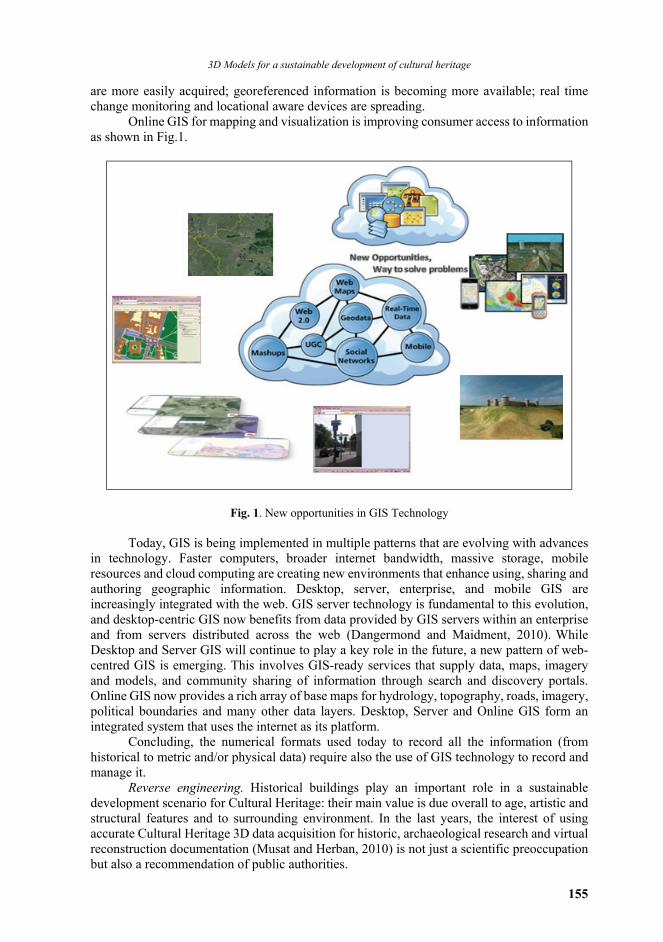
Online GIS for mapping and visualization is improving consumer access to information as shown in Fig.1.
Fig. 1. New opportunities in GIS Technology
Today, GIS is being implemented in multiple patterns that are evolving with advances in technology. Faster computers, broader internet bandwidth, massive storage, mobile resources and cloud computing are creating new environments that enhance using, sharing and authoring geographic information. Desktop, server, enterprise, and mobile GIS are increasingly integrated with the web. GIS server technology is fundamental to this evolution, and desktop-centric GIS now benefits from data provided by GIS servers within an enterprise and from servers distributed across the web (Dangermond and Maidment, 2010). While Desktop and Server GIS will continue to play a key role in the future, a new pattern of web-centred GIS is emerging. This involves GIS-ready services that supply data, maps, imagery and models, and community sharing of information through search and discovery portals. Online GIS now provides a rich array of base maps for hydrology, topography, roads, imagery, political boundaries and many other data layers. Desktop, Server and Online GIS form an integrated system that uses the internet as its platform.
Concluding, the numerical formats used today to record all the information (from historical to metric and/or physical data) require also the use of GIS technology to record and manage it.
Reverse engineering. Historical buildings play an important role in a sustainable development scenario for Cultural Heritage: their main value is due overall to age, artistic and structural features and to surrounding environment. In the last years, the interest of using accurate Cultural Heritage 3D data acquisition for historic, archaeological research and virtual reconstruction documentation (Musat and Herban, 2010) is not just a scientific preoccupation but also a recommendation of public authorities.

Vilceanu et al./Procedia Environmental Science, Engineering and Management, 2, 2015, 2, 153-160
156
Besides digital reconstruction, a study on monitoring and analysis of the structure of Cultural Heritage buildings becomes easier by testing the parameters that ensure the integrity and safety of the buildings using geodetic methods based on total station, close range photogrammetry or Laser Scan technology.
3D Laser Scan Technology allows user to produces a high-precision digital reference data that records condition, provides a virtual model for replication, and makes possible easy mass distribution of digital data. The cost and complexity of 3D laser scanning technologies have made 3D scanning impractical for many heritage institutions in the past, but this is changing, as an increasing number of commercial systems are being customized and marketed for heritage applications and also Photogrammetry begun to be used as complementary method to 3D laser scan technologies in domains such as architecture and civil engineering.
In this context various society fields demand realistic 3D city models for diverse purposes. For historical buildings even ancient fortresses, analysing in a 3D virtual reality world (Fig. 2) is much more efficient than imaging the 2D information on maps. Navigation systems and virtual tourism also benefit from realistic 3D city models. Manual creation of 3D city models is undoubtedly a rather slow and expensive procedure, because of the enormous number of buildings and complexity of building shapes this is why automated procedures substantiated on scientific protocols are necessary in an ICT (information and communication technologies) world (Forte, 2014).
Fig. 2. Assembling DTM with 3D Model process (Herban et al., 2014)
Studying international scientific literature, first thing one can notice is that there are
concerns and scientific work and papers of topicality showing embodiments of 3D models for spatial objects. Thus, there are scientific papers proposing the use of GIS for analysis and documentation of Cultural Heritage management but there is a lack of information regarding webGIS platforms referring to Cultural Heritage and 3D objects. This is due to:

3D Models for a sustainable development of cultural heritage
157
Most GIS or webGIS platforms are customized for analysing and managing land related data or public administration fees being provided by Esri, Intergraph, AutoDesk etc., as well as Open Source solutions: Grass GIS, Map Window GIS, QGIS etc.
Integrating spatial objects such as Cultural Heritage ones into webGIS platforms is quite difficult because of the fact that creating the 3D models of this kind of objects can be laborious and time consuming; besides creating the objects there is a need for the digital reconstruction of the original containing the missing parts and inserting the 3D model into a geodatabase represents a demanding process.
Current research in this domain differentiates between creating 3D models for Cultural Heritage objects or buildings and creating GIS solutions for them. There are methods and models for digital realization of both objects and buildings belonging to Cultural Heritage and there also are GIS solutions for Cultural Heritage purposes but most of them do not work with 3D models integrated into GIS platforms (Oreni et al., 2012). Moreover, the possibility of integrating 3D models (the model itself and a spatial analysis of its deformations) into customized Open Source or Low-Cost GIS platforms and the analysis of webGIS platforms and their functionalities for 3D Cultural Heritage has not been studied and realized, thus there is a lack of knowledge.
Patias and Santana (2009) have shown that the base line used in Cultural Heritage documentation implies a training approach that should identify and define the parameters relevant in particular heritage assessment. The chart in Fig. 3 depicts the components of a baseline record and information retrieval in the 3D Model. This baseline, additionally, could be used as starting point for designing and implementing a monitoring strategy, allowing detecting changes affecting the statement of significance of the heritage place. A baseline is defined by both a site report and a dossier of measured representations that could include a site plan, emplacement plan, plans of features, sections, elevations, three-dimensional models etc. The following checklist can be used as guideline to adequate requirements of information required for defining the baseline and training purposes: identify site location (centroid, boundaries, elements and buffer zone); identify and map evidences of criteria; significance and integrity assessment; risk assessment: threats and hazards associated to indicators; administrative and management issues (current and passed mitigations); other assessments.
Fig. 3. Defining a base line and 3D model Processing
3. Discussions
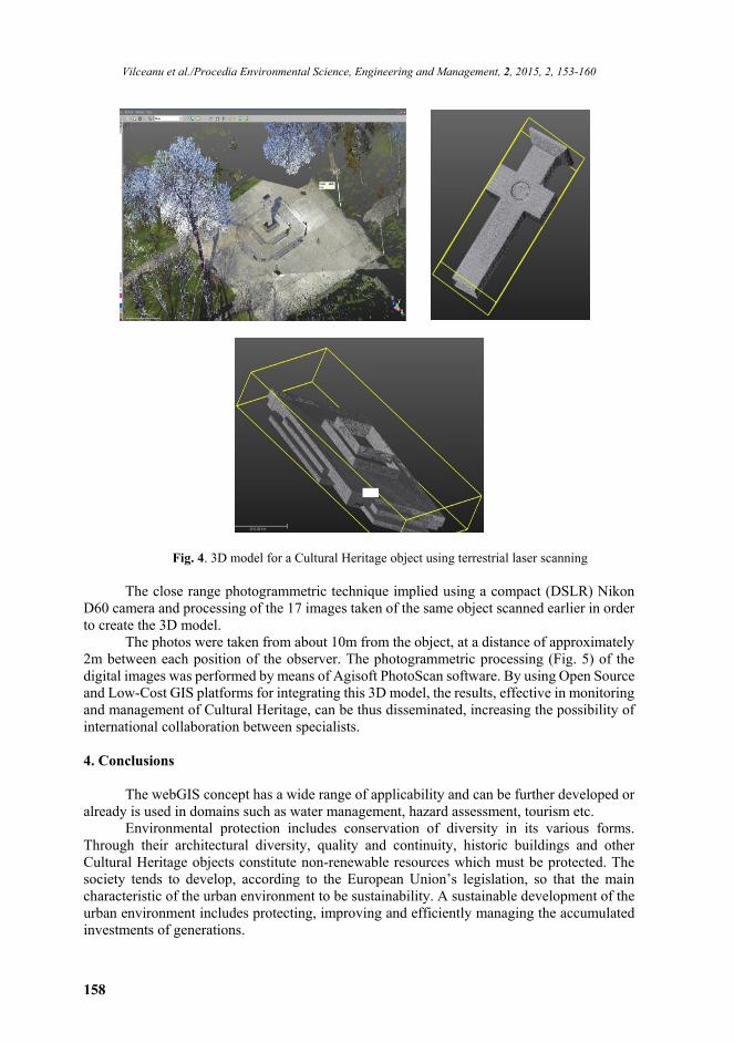
Data collection for the Cultural Heritage object (Fig. 4) using the terrestrial laser
scanning technology was realized with a Trimble scanner, the scanning session lasted 40minutes and the processing of the data was realized using Trimble RealWorks software.
Vilceanu et al./Procedia Environmental Science, Engineering and Management, 2, 2015, 2, 153-160
158
Fig. 4. 3D model for a Cultural Heritage object using terrestrial laser scanning
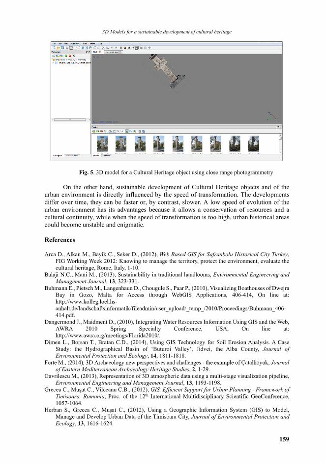
The close range photogrammetric technique implied using a compact (DSLR) Nikon
D60 camera and processing of the 17 images taken of the same object scanned earlier in order to create the 3D model.
The photos were taken from about 10m from the object, at a distance of approximately 2m between each position of the observer. The photogrammetric processing (Fig. 5) of the digital images was performed by means of Agisoft PhotoScan software. By using Open Source and Low-Cost GIS platforms for integrating this 3D model, the results, effective in monitoring and management of Cultural Heritage, can be thus disseminated, increasing the possibility of international collaboration between specialists.
4. Conclusions
The webGIS concept has a wide range of applicability and can be further developed or already is used in domains such as water management, hazard assessment, tourism etc.
Environmental protection includes conservation of diversity in its various forms. Through their architectural diversity, quality and continuity, historic buildings and other Cultural Heritage objects constitute non-renewable resources which must be protected. The society tends to develop, according to the European Union’s legislation, so that the main characteristic of the urban environment to be sustainability. A sustainable development of the urban environment includes protecting, improving and efficiently managing the accumulated investments of generations.
3D Models for a sustainable development of cultural heritage
159
Fig. 5. 3D model for a Cultural Heritage object using close range photogrammetry On the other hand, sustainable development of Cultural Heritage objects and of the
urban environment is directly influenced by the speed of transformation. The developments differ over time, they can be faster or, by contrast, slower. A low speed of evolution of the urban environment has its advantages because it allows a conservation of resources and a cultural continuity, while when the speed of transformation is too high, urban historical areas could become unstable and enigmatic. References Arca D., Alkan M., Bayik C., Seker D., (2012), Web Based GIS for Safranbolu Historical City Turkey,
FIG Working Week 2012: Knowing to manage the territory, protect the environment, evaluate the cultural heritage, Rome, Italy, 1-10.
Balaji N.C., Mani M., (2013), Sustainability in traditional handlooms, Environmental Engineering and Management Journal, 13, 323-331.
Buhmann E., Pietsch M., Langenhaun D., Chougule S., Paar P., (2010), Visualizing Boathouses of Dwejra Bay in Gozo, Malta for Access through WebGIS Applications, 406-414, On line at: http://www.kolleg.loel.hs-anhalt.de/landschaftsinformatik/fileadmin/user_upload/_temp_/2010/Proceedings/Buhmann_406-414.pdf.
Dangermond J., Maidment D., (2010), Integrating Water Resources Information Using GIS and the Web, AWRA 2010 Spring Specialty Conference, USA, On line at: http://www.awra.org/meetings/Florida2010/.
Dimen L., Borsan T., Bratan C.D., (2014), Using GIS Technology for Soil Erosion Analysis. A Case Study: the Hydrographical Basin of ‘Buturoi Valley’, Jidvei, the Alba County, Journal of Environmental Protection and Ecology, 14, 1811-1818.
Forte M., (2014), 3D Archaeology new perspectives and challenges - the example of Çatalhöyük, Journal of Eastern Mediterranean Archaeology Heritage Studies, 2, 1-29.
Gavrilescu M., (2013), Representation of 3D atmospheric data using a multi-stage visualization pipeline, Environmental Engineering and Management Journal, 13, 1193-1198.
Grecea C., Muşat C., Vîlceanu C.B., (2012), GIS, Efficient Support for Urban Planning - Framework of Timisoara, Romania, Proc. of the 12th International Multidisciplinary Scientific GeoConference, 1057-1064.
Herban S., Grecea C., Muşat C., (2012), Using a Geographic Information System (GIS) to Model, Manage and Develop Urban Data of the Timisoara City, Journal of Environmental Protection and Ecology, 13, 1616-1624.
Vilceanu et al./Procedia Environmental Science, Engineering and Management, 2, 2015, 2, 153-160
160
Herban S.I., Rusu G., Grecea O., Birla G.A., (2014), Using the laser scanning for research and conservation of cultural heritage sites. Case study: Ulmetum Citadel, Journal of Environmental Protection and Ecology, 15, 1172-1181.
Muşat C.C., Herban I.S., (2012), Study on reverse engineering of historical architecture in Timisoara based on 3D laser point technologies, Journal of Environmental Protection and Ecology, 13, 1107-1116.
Oreni D., Cuca B., Burumana R., (2012), Three-Dimensional Virtual Models for Better Comprehension of Architectural Heritage Construction Techniques and its Maintenance Over Time, EuroMed'12 Proceedings of the 4th International Conference on Progress in Cultural Heritage Preservation, 533-542, Berlin.
Patias P., Santana M., (2009), Introduction to Heritage Documentation, In: CIPA Heritage Documentation - Best Practices and Applications, Santana Quintero M., Patias P., Stylianidis E. (Eds.), Volume XXXVIII-5/C19, Athens, Greece.