2007 Raleigh Colony Investigation: Magnetic Anomaly ... · PDF file2007 Raleigh Colony...
12
2007 Raleigh Colony Investigation: Magnetic Anomaly Identification & Assessment Roanoke Sound and Shallowbag Bay Roanoke Island, North Carolina
Transcript of 2007 Raleigh Colony Investigation: Magnetic Anomaly ... · PDF file2007 Raleigh Colony...

2007 Raleigh Colony Investigation: Magnetic Anomaly Identification & Assessment
Roanoke Sound and Shallowbag Bay Roanoke Island, North Carolina

2007 Raleigh Colony Investigation: Magnetic Anomaly Identification & Assessment
Roanoke Sound and Shallowbag Bay Roanoke Island, North Carolina
Submitted to:
First Colony Foundation 1910 Sedwick Road
Suite 400C, Building 400 Durham, North Carolina 27713
Submitted by:
Gordon P. Watts, Jr. Director
Institute for International Maritime Research, Inc. Post Office Box 2489
Washington, North Carolina 27889
5 August 2008

Introduction Historical documentation and the physical environment suggest that the site of the Raleigh Colony was on the north end of Roanoke Island. Historical and cartographic research confirms that the north end of Roanoke Island has eroded extensively since the sixteenth century. Because of the extent of that erosion, it is possible that the surviving remains of the Raleigh Colony site now lie beneath the shallow waters of Roanoke Sound. Although no evidence of the site was identified by remote sensing investigations carried out in the mid-1980s under the direction of archaeologist Gordon Watts, improved contemporary remote sensing and electronic positioning could identify very subtle diagnostic features and small artifacts associated with the sixteenth-century settlement. In 2002, the Institute for International Maritime Research, Inc. (I2MR) carried out a remote sensing survey of two high-probability areas off the north end of Roanoke Island. Data from that survey activity confirmed the presence of numerous magnetic anomalies that could have a potential association with the Raleigh Colony site. With funding provided by First Colony Foundation (FCF), archaeologists from I2MR and volunteers from the Maritime Archaeological and Historical Society (MAHS) have carried out investigations of selected anomalies in 2005 and 2006. Those investigations were designed to identify material generating the magnetic signatures and to assess its potential association with the Raleigh Colony site. During the period between 10 and 15 September 2007, adverse weather resulted in the loss of all but one day of investigation. During that one day, a total of 4 anomaly clusters were relocated and investigated. Principal Investigator Gordon P. Watts carried out the anomaly testing with assistance from archaeological assistants William Utley, Raymond Hayes and Randy Little. None of the material generating those anomalies was found to be associated with the Raleigh Colony. During the 2007 investigation, Ralph Wilbanks and Darrell Taylor of Diversified Wilbanks, a Yonges Island, South Carolina corporation, attempted to carry out additional magnetic remote sensing survey off the north end of the island. The remote sensing survey was cancelled due to adverse weather conditions. The Raleigh Colony Project research was undertaken in accordance with the terms of a permit issued by the North Carolina Department of Cultural Resources. 2007 Investigation Adverse weather during the 10-15 September 2007, field investigation created the necessity for daily restructuring of objectives. On 11 September winds of 15 to 25 knots made remote sensing impossible so a walking visual (Figure 1) and hand held detector (Figure 2) survey along the shoreline and shallow water east of the Lost Colony theater was carried out by project personnel (Figure 3). That investigation

2
identified a small, thirty pound, 19th century anchor (Figure 4) and a large engine casting used for a mooring in the vicinity of the sand spit. By the time the eastern extremity of the sand spit had been investigated, high winds and rough sea state required terminating the survey.
Figure 1. Examining the shoreline and shallow water east of the Lost Colony waterside theater.

3
Figure 2. Ray Hayes using a metal detector during the shoreline and shallow water survey.
Figure 3. Area covered by the shoreline and shallow water survey.

4
Figure 4. Small boat anchor found near the sand spit during the shallow water survey.
On 14 September 2007, the single day of target investigation permitted by adverse weather, four anomaly clusters were identified. Two were located off the northeast end of Roanoke Island in the north area surveyed in 2005 (Figure 5). The anomalies were relocated using a hand held magnetometer. Each anomaly was probed and/or exposed using an induction dredge to identify material generating the magnetic signature. Anomaly cluster NRS-01 proved to be the remains of several crab traps. Anomaly cluster NRS-02 proved to be several lengths of small diameter iron pipe.

5
Figure 5. Target NRS-01 and NRS-02 locations in Roanoke Sound.
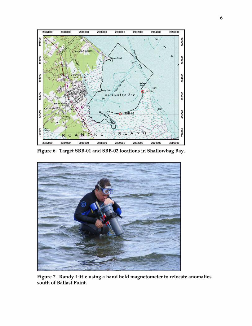
In the afternoon wind and sea state exceeded safe working conditions in Roanoke Sound, target investigation was moved into Shallowbag Bay. The first target investigated was a cluster of anomalies along the shoreline immediately south of Ballast Point (Figure 6). The anomalies were relocated using a hand held magnetometer (Figure 7). Each anomaly was probed and/or exposed using an induction dredge to identify material generating the magnetic signature. The Ballast Point anomalies were identified as crab trap remains associated with a concentration of oyster shells.
6
Figure 6. Target SBB-01 and SBB-02 locations in Shallowbag Bay.
Figure 7. Randy Little using a hand held magnetometer to relocate anomalies south of Ballast Point.

7
The second target investigated was a cluster of anomalies along the shoreline east of the mouth of Scarboro Creek (Figure 6). Those anomalies were also relocated using the hand held magnetometer. Anomalies in the cluster were hydraulically probed and/or exposed using an induction dredge to identify material generating the magnetic signature (Figure 8). The Scarboro Creek anomalies were related to sections of medium size pipe and additional crab trap material.
Figure 8. Bill Utley and Randy Little probing targets east of the mouth of Scarboro Creek.
Results of the 2007 Investigation The 2007 Roanoke Island investigation was plagued by bad weather. Weather was good enough for fieldwork for only a portion of 11 September and most of 14 September. Wind direction on 11 September permitted an examination along the shoreline and shallow water east of the Lost Colony waterside theater. That investigation identified modern debris, but nothing associated with the Roanoke colonists. On 14 September more moderate winds in the morning permitted two anomaly clusters in and adjacent to the north survey area in Roanoke Sound associated with the inundated remains of Shallowbag Bay. Higher winds in the afternoon forced moving target assessment operations into Shallowbag Bay and two additional target
8
sites were examined. Neither the targets in Ronoke Sound nor those in Shallowbag Bay were found to be associated with 16th century activities. Recommendations for Additional Investigation Results of the 2007 shoreline and shallow water survey and anomaly identification investigation at Roanoke Island provide little new insight into the nature of material generating magnetic anomalies either in Roanoke Sound or Shallowbag Bay. Investigation proposed for the fall of 2008 should be focused on two objectives. The first objective should be continued anomaly identification along the north shore of Roanoke Island and in Shallowbag Bay. The number of targets in Sahlowbag Bay (Figure 9) indicates that the area could contain 16th century material in addition to modern debris.

9
Figure 9. Anomalies identified during the 2006 Shallowbag Bay magnetic remote sensing investigation. The second objective should be a remote sensing survey and limited target assessment in Broad Creek northeast of Wanchese (Figure 10). Although surrounded by marsh today, 500 years ago that estuary could have afforded a safe harbor for the small vessels of the Roanoke colonists. The identification and recovery of several artifacts that could be associated with 16th century activity on Roanoke Island reinforces the possibility that additional material could be located in the creek bottom sediments.

10
Figure 10. Map of the proposed Broad Creek survey area.
A high-resolution sub-bottom profiler will be used in both areas to attempt to identify any stratigraphic features in the sediment are suggestive of habitable landforms or embayments and streams that could have been a source of fresh water. An extension of the permit for underwater archaeological investigations from the North Carolina Department of Cultural Resources will be requested to continue proposed investigations. Continued investigation will be scheduled for late September or early October 2008.