1 OPTIS information systems applications Standardisation and interoperability Critical analysis of...
14
1 OPTIS information systems applications Standardisation and interoperability Critical analysis of ongoing infrastructure activities Gil DENIS (Matra Systèmes & Information) [email protected]
-
Upload
peter-campbell -
Category
Documents
-
view
216 -
download
1
Transcript of 1 OPTIS information systems applications Standardisation and interoperability Critical analysis of...

1
OPTIS information systems applications
Standardisationand interoperability
Critical analysis ofongoing infrastructure activities
Gil DENIS (Matra Systèmes & Information) [email protected]

2
OPTIS information systems applications
Which needs for an European information distribution infrastructure ?
Market place model confirmed : data providers + value adders +
customers
Information packages defined as specific end products :combining EO + GIS + statistical
information + text + HTML
Needs for meta-information but also information access.
From technology driven market...
...to customers or end users driven market.
Satellite dataprovider
Value added dataand service provider
GIS dataprovider
Value added dataand service provider
Value added dataand service provider
InformationMarket place
Non-EO dataprovider
Users
Users
User

3
OPTIS information systems applications
Which needs for an European information distribution infrastructure ?
2 end users or customers types :Experts (use specific tools for EO and GIS information
processing).Decision makers (the information is the end product which
helps the decision-making process)
and intermediate level value adders.
Interoperability helps to set-up operational services
Dataavailability
Webcompliant
Removefrontiers
Fusion &aggregation
Readyfor use
Specificadded value
package

4
OPTIS information systems applications
European road map from 1996 to 2000
19981999
2000
Implementation&
experimentation
1996
Experience&
feedbackCIP
Search server
CLIENTS GATEWAYS Existingcatalogues
-
No real services distribution. Based on a complex protocol Z39.50. Not suitable for VA (no processing). No on-line data retrieval.
+
Homogenous access to catalogues. Full syntactical and semantic interoperability for EO.

5
OPTIS information systems applications
CORBIP Information provider
ProcessingInventory
Inventory
AccessAccess
CORBA network
YellowPages
UserManager
Processing
VA
Ordering
Ordering
E-commerce
UM
YP Inventory
AccessAccess to
remoteservices
Full data and services distribution. Full syntactical & semantic definition (IDL). Product access : on-line & order. Value adding services. Access control suitable for e-commerce. Support of XML format for results. Long term technological investment. Open system: extension to new services and data.
Guide
Customers &End users
CORBIP : towards integrated data and service distribution

6
OPTIS information systems applications
US initiatives : competition or synergy
IMS - NASA development :Best deployed operational infrastructure.But insufficient interoperability and obsolete technology.
OpenGIS - developed by the OGC :Aimed at defining a “Comprehensive specification of software
framework for distributed access to geodata and geoprocessing resources”.
“Specification independent of distributed computing platform”.“Universal open Geodata Model”.
Risk : too ambitious to build an operational infrastructure ?US industry leadership ?
Doubts : usable basis for Value Adders ?
7
OPTIS information systems applications
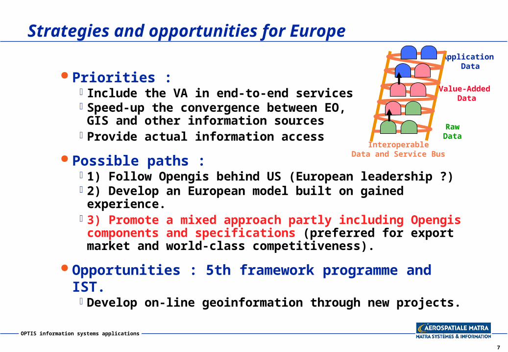
Strategies and opportunities for Europe
Priorities :Include the VA in end-to-end servicesSpeed-up the convergence between EO,
GIS and other information sourcesProvide actual information access
Possible paths :1) Follow Opengis behind US (European leadership ?)2) Develop an European model built on gained experience.3) Promote a mixed approach partly including Opengis
components and specifications (preferred for export market and world-class competitiveness).
Opportunities : 5th framework programme and IST.Develop on-line geoinformation through new projects.
InteroperableData and Service Bus
Application Data
Value-Added Data
Raw Data

8
OPTIS information systems applications
Reminder : first define the customer relationship and the business model
Data &rights
holder n°1
Dataprovider
Enduser
Valueadded
Serviceprovider
End user(targeted
application)
Data &rights
holder n°NData &rights
holder n°2Internetworking and
interoperability makes value-adding easier
Yearly fee basedon sharing added value
licence agreement
licenceagreement
with share of added value

9
OPTIS information systems applications
European CORBIP Provider
ProcessingInventory
Inventory
AccessAccess
CORBA network
YellowPages
UserManager
Processing
VA
UM
YP Inventory
Access
access toexportedservices
Inventory Access
GIS EO Meteo
CORBIP/CIPgateway
INFEO
OpenGIS compliant
system
Customers & end users
E-commerce& VA
Future European infrastructure : possible models
10
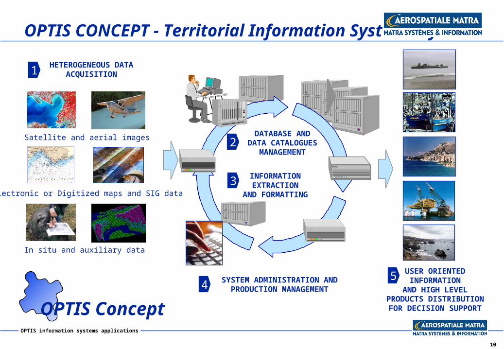
OPTIS information systems applications
OPTIS CONCEPT - Territorial Information Systems by
HETEROGENEOUS DATAACQUISITION
INFORMATIONEXTRACTION
AND FORMATTING
USER ORIENTEDINFORMATION
AND HIGH LEVELPRODUCTS DISTRIBUTIONFOR DECISION SUPPORT
DATABASE ANDDATA CATALOGUES
MANAGEMENT
Satellite and aerial images
In situ and auxiliary data
Electronic or Digitized maps and SIG data
1
2
3
4 SYSTEM ADMINISTRATION ANDPRODUCTION MANAGEMENT
5
OPTIS Concept

11
OPTIS information systems applications
Example n°1 : decision support service for fishing companies
SPACECOMMUNICATIONS
EARTH OBSERVATION(ERS, NOAA, SEAWIFS)
Information server“Fishing areas”
Information server“Fleet managementand private data”
Image receivingstation
Secured data-link
FISHING FLEET
On-line andinteractive access to
“high fishing probability” areas
Data linkbetween fishing company
and its vessels
The two servers are the main components of an integrated
fishing support service
PositionbyGPS

12
OPTIS information systems applications
Fishing support service : hidden interoperability
High levelreal timeproducts
Real timedata sources
Modelingand scientific
expertise
Static or semi-static data
Off-lineFish catches
and fish positionIn-situ
information
Derivedinformationextraction
Resultsvalidation
Patrimonialarchive
- Sea suface temperature- Vorticity- Ocean color- Sea level anomaly- Meteorology
- Isothermal contour lines- Sea level contour lines - Phytoplanktonconcentration- Plankton /Clear water transition- Current lines, whirls andup-welling.- etc.
- Bathymetry- Long term statistics(wave height, current).
- Buoys- Temperature sensors onship or net- Sounders- etc.
- GPS or ARGOS plots- Fishing log books- Captains comments
- Biological models(food webs dynamic)- Ocean dynamic forecasting- high potential fishingareas definition
- Compressed digital maps- Fax bulletin- Text message
- Fish catches vs fishingrecommendations- Statistics
13
OPTIS information systems applications
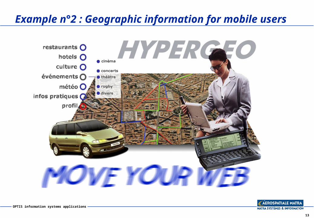
Example n°2 : Geographic information for mobile users

14
OPTIS information systems applications
HYPERGEO : operational concept
HÔTEL
HÔTEL
HÔTEL
HYPERGEOSERVER
HYPERGEOCALL
CENTRE
Externaldistributedresources
2. Other resources
1. HYPERGEO external resources
(partnership agreement)
HYPERGEOEND
USERS
HYPERGEOPROFESSIONAL
USERS
At home access, before traveling
Mobile access during travel
Hotels, tour operators,travel companies
HYPERGEOEND
USERS