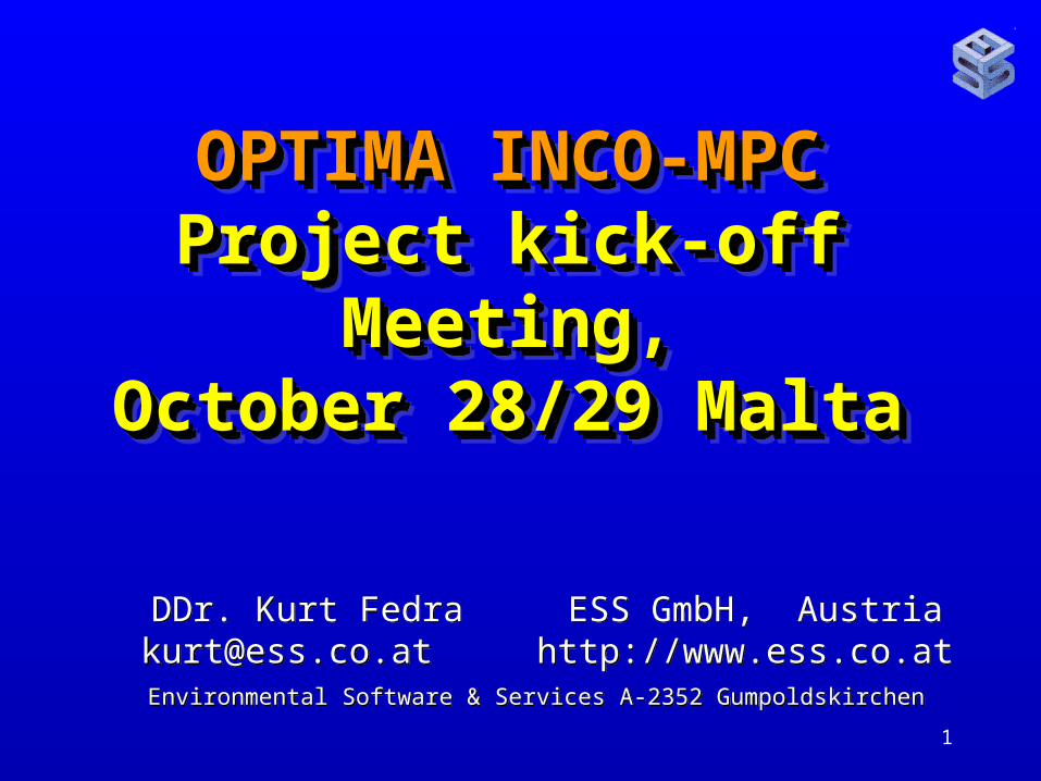
1 OPTIMA INCO-MPC Project kick-off Meeting, October 28/29 Malta DDr. Kurt Fedra ESS GmbH, Austria...
40
1 OPTIMA INCO-MPC OPTIMA INCO-MPC Project kick-off Project kick-off Meeting, Meeting, October 28/29 Malta October 28/29 Malta DDr. Kurt Fedra ESS GmbH, Austria [email protected] http://www.ess.co.at Environmental Software & Services A-2352 Gumpoldskirchen
-
Upload
loraine-short -
Category
Documents
-
view
214 -
download
0
Transcript of 1 OPTIMA INCO-MPC Project kick-off Meeting, October 28/29 Malta DDr. Kurt Fedra ESS GmbH, Austria...
1
OPTIMA INCO-MPCOPTIMA INCO-MPCProject kick-offProject kick-off Meeting,Meeting,
October 28/29 MaltaOctober 28/29 Malta
OPTIMA INCO-MPCOPTIMA INCO-MPCProject kick-offProject kick-off Meeting,Meeting,
October 28/29 MaltaOctober 28/29 Malta
DDr. Kurt Fedra ESS GmbH, [email protected] http://www.ess.co.at
Environmental Software & Services A-2352 Gumpoldskirchen
DDr. Kurt Fedra ESS GmbH, [email protected] http://www.ess.co.at
Environmental Software & Services A-2352 Gumpoldskirchen

2
WP03: ModellingWP03: Modelling
MODELS provide a
• Formal
• Structured
• Quantitative
description of the problems and possible solutions.
MODELS provide a
• Formal
• Structured
• Quantitative
description of the problems and possible solutions.

3
WP03: ModellingWP03: ModellingWP1: identifies problem issues, develops a
structure for the description of the cases, identifies data needs and availability, constraints;
WP2 analyzes perceptions and preferences, institutional or regulatory frameworks, plausible socio-economic developments;
WP4 compiles the set of ALTERNATIVE WATER TECHNOLOGIES that can be used;
WP5 looks into LAND USE change as one of the major driving forces, consistent with WP 2.
WP1: identifies problem issues, develops a structure for the description of the cases, identifies data needs and availability, constraints;
WP2 analyzes perceptions and preferences, institutional or regulatory frameworks, plausible socio-economic developments;
WP4 compiles the set of ALTERNATIVE WATER TECHNOLOGIES that can be used;
WP5 looks into LAND USE change as one of the major driving forces, consistent with WP 2.

4
WP03: ModellingWP03: Modelling
WP1, 2, 4 and 5 develop the boundary conditions and specifications for
• Complete
• Consistent• Plausible
Set of SCENARIOS for simulation modelling and optimization.
WP1, 2, 4 and 5 develop the boundary conditions and specifications for
• Complete
• Consistent• Plausible
Set of SCENARIOS for simulation modelling and optimization.

5
WP03: ModellingWP03: Modelling
WaterWare dynamic water resources model (daily, annual) optimization
Embedded models:• RRM rainfall-runoff model • Automatic RRM calibration• IRWDM irrigation water demand modelRelated model:• LUC dynamic land use change model
WaterWare dynamic water resources model (daily, annual) optimization
Embedded models:• RRM rainfall-runoff model • Automatic RRM calibration• IRWDM irrigation water demand modelRelated model:• LUC dynamic land use change model

6
WP 3: ModellingWP 3: Modelling
Models provide estimates for
1. Economic efficiency
2. Environmental compatibility
3. Equity (intra- and intergenerational)
Models provide estimates for
1. Economic efficiency
2. Environmental compatibility
3. Equity (intra- and intergenerational)

7
WP03: ModellingWP03: ModellingLUC: land use change model• Discrete state (LUC) transition model• Markov chain with stochastic transition
probabilities• Rule-based constraints and TP adjustments• Temporal resolution: year, scope: decades (20-
50 years)• Spatial resolution: ha to km2
• Resource use and pollution as land-use specific output;
• Possibility for external, global driving forces
LUC: land use change model• Discrete state (LUC) transition model• Markov chain with stochastic transition
probabilities• Rule-based constraints and TP adjustments• Temporal resolution: year, scope: decades (20-
50 years)• Spatial resolution: ha to km2
• Resource use and pollution as land-use specific output;
• Possibility for external, global driving forces

8
WP03: LUC ModellingWP03: LUC Modelling
Global/local adjustments of the transition probabilities expressed as
First-order logic RULES
in relative terms (INCREASE, DECREASE in %).
http://www.ess.co.at/SMART/luc.html
Global/local adjustments of the transition probabilities expressed as
First-order logic RULES
in relative terms (INCREASE, DECREASE in %).
http://www.ess.co.at/SMART/luc.html

9

10

11

12
WP03: LUC ModellingWP03: LUC Modelling
Interactive editors for1. Land use classes2. Transition probabilities3. Modifying rules4. Class specific resource needs/outputs
are available on-line together with the viewer (player for animated results)
Links from http://www.ess.co.at/SMART will be moved to http://ww.ess.co.at/OPTIMA
Interactive editors for1. Land use classes2. Transition probabilities3. Modifying rules4. Class specific resource needs/outputs
are available on-line together with the viewer (player for animated results)
Links from http://www.ess.co.at/SMART will be moved to http://ww.ess.co.at/OPTIMA

13

14
WP03: LUC ModellingWP03: LUC Modelling
Derived values per unit area, class specific:
1. Water consumption2. Waste water generated3. Energy use4. Solid waste production
OTHERS ??
Derived values per unit area, class specific:
1. Water consumption2. Waste water generated3. Energy use4. Solid waste production
OTHERS ??

15

16
WP03: ModellingWP03: Modelling
LUC EXTENSIONS:
Include transportation network in rules (connectivity)
Other external variables (specified as time series)
More LUC specific coefficients and processes (employment, value added, etc)
LUC EXTENSIONS:
Include transportation network in rules (connectivity)
Other external variables (specified as time series)
More LUC specific coefficients and processes (employment, value added, etc)

17
WP03: ModellingWP03: Modelling
LUC OBJECTIVES:
1.Hypothesis testing
2. Developing CONSISTENT scenarios with high explanatory value that can also be used directly in the rainfall-runoff basin water budget model
LUC OBJECTIVES:
1.Hypothesis testing
2. Developing CONSISTENT scenarios with high explanatory value that can also be used directly in the rainfall-runoff basin water budget model

18
WP03: ModellingWP03: Modelling
RRM: rainfall-runoff model• Dynamic, daily time step• Uses daily rainfall and temperature• Major basin characteristic: LAND USE
(summarized from LUC scenarios ??)• Estimates runoff and dynamic water
budget for ungaged basins, provides input for WRM start nodes (catchment)
RRM: rainfall-runoff model• Dynamic, daily time step• Uses daily rainfall and temperature• Major basin characteristic: LAND USE
(summarized from LUC scenarios ??)• Estimates runoff and dynamic water
budget for ungaged basins, provides input for WRM start nodes (catchment)
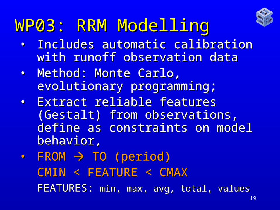
19
WP03: RRM ModellingWP03: RRM Modelling• Includes automatic calibration with runoff
observation data• Method: Monte Carlo, evolutionary
programming; • Extract reliable features (Gestalt) from
observations, define as constraints on model behavior,
• FROM TO (period) CMIN < FEATURE < CMAX FEATURES: min, max, avg, total, values
• Includes automatic calibration with runoff observation data
• Method: Monte Carlo, evolutionary programming;
• Extract reliable features (Gestalt) from observations, define as constraints on model behavior,
• FROM TO (period) CMIN < FEATURE < CMAX FEATURES: min, max, avg, total, values

20

21

22
23
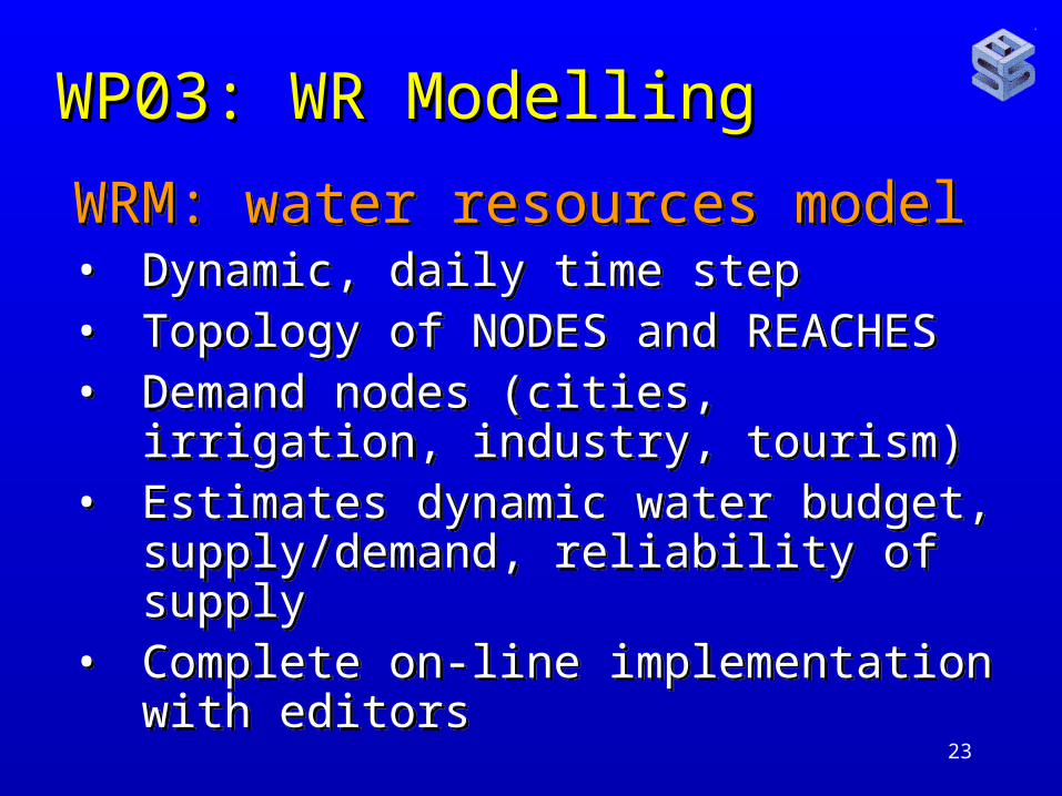
WP03: WR ModellingWP03: WR Modelling
WRM: water resources model• Dynamic, daily time step• Topology of NODES and REACHES• Demand nodes (cities, irrigation,
industry, tourism)• Estimates dynamic water budget,
supply/demand, reliability of supply• Complete on-line implementation with
editors
WRM: water resources model• Dynamic, daily time step• Topology of NODES and REACHES• Demand nodes (cities, irrigation,
industry, tourism)• Estimates dynamic water budget,
supply/demand, reliability of supply• Complete on-line implementation with
editors

24
WP03: ModellingWP03: Modelling
User/scenario management:• User authentication by name and
password (monitored … )• User can see and copy ALL scenarios,
edit/delete only their own !• TEST scenarios installed as EXAMPLES
to demonstrate features implemented • On-line manual pages
User/scenario management:• User authentication by name and
password (monitored … )• User can see and copy ALL scenarios,
edit/delete only their own !• TEST scenarios installed as EXAMPLES
to demonstrate features implemented • On-line manual pages

25

26
WP03: ModellingWP03: Modelling
Model structure:Topology (network) of NODES, connected
by REACHES;NODES represent functional OBJECTS in
the basin:• Sub-catchments, well(s) fields, springs• Reservoirs, structures• Water demand: cities, irrigation districts,
industries, environmental uses (wetlands, minimum flow)
Model structure:Topology (network) of NODES, connected
by REACHES;NODES represent functional OBJECTS in
the basin:• Sub-catchments, well(s) fields, springs• Reservoirs, structures• Water demand: cities, irrigation districts,
industries, environmental uses (wetlands, minimum flow)

27
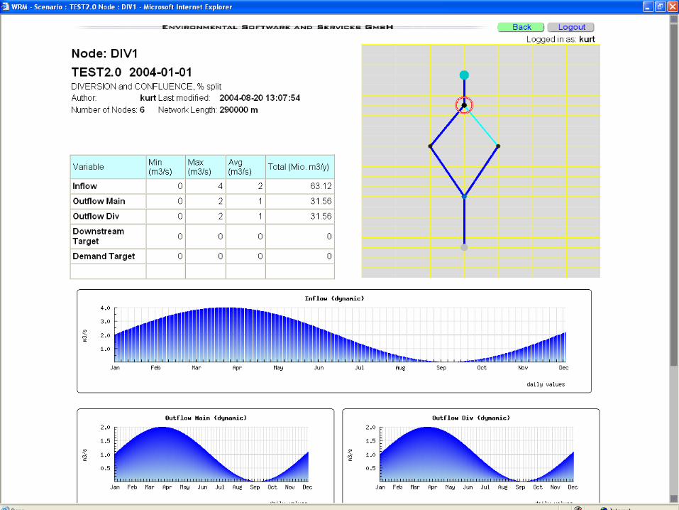
WP03: ModellingWP03: Modelling
Model structure:Topology (network) of NODES, connected
by REACHES:Represent natural and man-made channels,
canals, pipelines that transfer (route) water between NODES.
Networks include:• Diversions (splitting the flow)• Confluences (merging flow)
Model structure:Topology (network) of NODES, connected
by REACHES:Represent natural and man-made channels,
canals, pipelines that transfer (route) water between NODES.
Networks include:• Diversions (splitting the flow)• Confluences (merging flow)

28
29
30
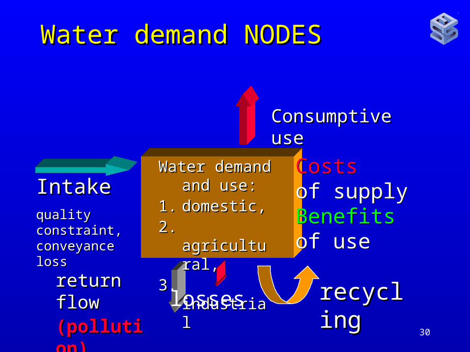
Water demand NODESWater demand NODES
IntakeIntakequality constraint, quality constraint, conveyance lossconveyance loss
Consumptive useConsumptive use
recyclingrecyclingreturn flowreturn flow(pollution)(pollution)
Water demand Water demand and use:and use:
1.1. domestic,domestic,2.2. agricultural,agricultural,3.3. industrialindustrial
Costs of supply Benefits of use
Costs of supply Benefits of use
losses

31
WP03: ModellingWP03: Modelling
DEMAND NODE is defined by• Its type (domestic, industrial, agricultural)
• Its connectivity (upstream, downstream, aquifer)
• Its water demand (time series)• Conveiance losses (evaporation, seepage)
• Consumptive use fraction, resulting in• return flow, and its losses• Quality changes (pollution)
• Costs of supply – Benefits of use

32

33

34
WP03: ModellingWP03: Modelling
WRM EXTENSIONS:1. Full groundwater coupling, single or
multi-cell aquifers with Darcy-flow coupling, in/exfiltration for reaches
2. Quality integration (return flow)3. Economic analysis:
1. Water efficiency; added value/unit water2. Cost-benefit analysis, requires, per node:
Investment, lifetime, OMR, discount rate

35
WP03: ModellingWP03: Modelling
Full groundwater coupling, single or multi-cell aquifers with Darcy-flow coupling, in/exfiltration for reaches
Every node is optionally connected to an AQUIFER OBJECT:
1. Extracting water from it (wells, infiltration (lateral inflow, baseflow contribution) into reaches, depending on relative levels
2. Returning water to it: seepage losses, explicit recharge

36
WP5-9: ModellingWP5-9: Modelling
REMEMBER:
• Model applications are THE central part of the case studies !!!
• All data compilation in view of model input data requirements
REMEMBER:
• Model applications are THE central part of the case studies !!!
• All data compilation in view of model input data requirements
37
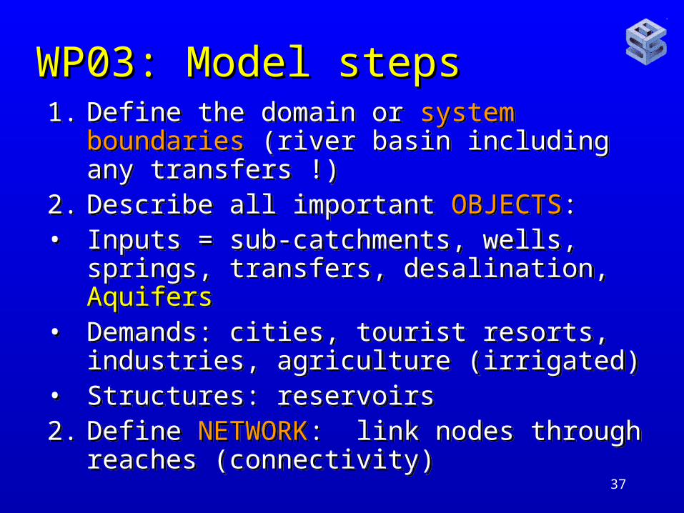
WP03: Model stepsWP03: Model steps1. Define the domain or system boundaries
(river basin including any transfers !)2. Describe all important OBJECTS:• Inputs = sub-catchments, wells, springs,
transfers, desalination, Aquifers• Demands: cities, tourist resorts,
industries, agriculture (irrigated)• Structures: reservoirs 2. Define NETWORK: link nodes through
reaches (connectivity)
1. Define the domain or system boundaries (river basin including any transfers !)
2. Describe all important OBJECTS:• Inputs = sub-catchments, wells, springs,
transfers, desalination, Aquifers• Demands: cities, tourist resorts,
industries, agriculture (irrigated)• Structures: reservoirs 2. Define NETWORK: link nodes through
reaches (connectivity)

38
WP03: Model stepsWP03: Model steps1. Compile and edit the DATA for the
NODES and REACHES:– Time series of flow, pumping, water
demand, diversion, reservoir release as rules or explicit time series,
– Loss coefficients– Consumptive use fractions,– Costs (investment, OMR, and benefits per
units water supplied/used;
2. Edit one or more scenarios, document3. RUN the model, evaluate runs.
1. Compile and edit the DATA for the NODES and REACHES:
– Time series of flow, pumping, water demand, diversion, reservoir release as rules or explicit time series,
– Loss coefficients– Consumptive use fractions,– Costs (investment, OMR, and benefits per
units water supplied/used;
2. Edit one or more scenarios, document3. RUN the model, evaluate runs.
39
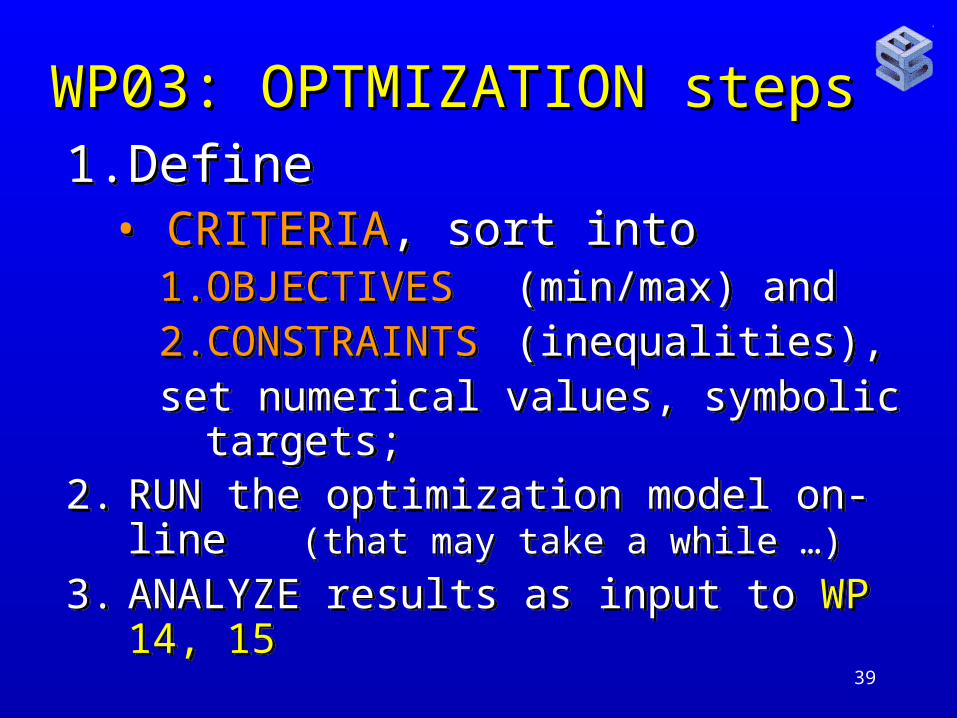
WP03: OPTMIZATION stepsWP03: OPTMIZATION steps1. Define
• CRITERIA, sort into 1. OBJECTIVES (min/max) and 2. CONSTRAINTS (inequalities), set numerical values, symbolic targets;
2. RUN the optimization model on-line (that may take a while …)
3. ANALYZE results as input to WP 14, 15
1. Define• CRITERIA, sort into
1. OBJECTIVES (min/max) and 2. CONSTRAINTS (inequalities), set numerical values, symbolic targets;
2. RUN the optimization model on-line (that may take a while …)
3. ANALYZE results as input to WP 14, 15

40
WP03: OPTMIZATION stepsWP03: OPTMIZATION stepsOPTIMIZATION generates sets of feasible
alternatives, each optimal in some (well defined) sense;
Discrete multi-criteria methodology SELECTS a single preferred solution from that set by defining preferences and trade-offs (multi-criteria) interactively:
Users explore the decision space to learn what can be obtained, and for what price (the trade-offs) and how to approach their UTOPIA solutions.
OPTIMIZATION generates sets of feasible alternatives, each optimal in some (well defined) sense;
Discrete multi-criteria methodology SELECTS a single preferred solution from that set by defining preferences and trade-offs (multi-criteria) interactively:
Users explore the decision space to learn what can be obtained, and for what price (the trade-offs) and how to approach their UTOPIA solutions.