


Languages
Pages
Legal


Optech's prominence as a world leader in the development and manufacture of advanced laser-based survey and imaging instruments
extends over 35 years. During this time, Optech has worked closely with academic, government, military, naval, air force and space-
based organizations to meet their specialized application requirements. From this innovation heritage, our commercial terrestrial
survey clients have come to depend on us to provide industry leadership in new technologies to maximize their data collection accuracy
and efficiency.
In 2001, Optech created the ILRIS-3D Intelligent Laser Ranging and Imaging System. A direct result of our efforts with the Canadian
Space Agency, this tripod-mounted system quickly scans and outputs XYZ geospatial data to produce highly accurate 3D point cloud
information of a surveyed scene. This technological achievement was commercialized specifically to meet the demanding terrestrial
survey market.
The past decade has seen tremendous growth in lidar scanning and imaging applications. The demand for 3D images and datasets is
increasingly common in projects and project requirements. As consumer confidence grows, more applications and projects are adding
3D laser scan data as a deliverable product. While surveyors continue to embrace 3D laser scanning in their workflows, the demand for
accuracy and efficiency improvements drives product development and innovation. And once again Optech has answered. The ILRIS-HD
High Density Laser Scanner and the latest ILRIS-LR Long Range Laser Scanner deliver increased performance and accuracy—to capture
every dimension.
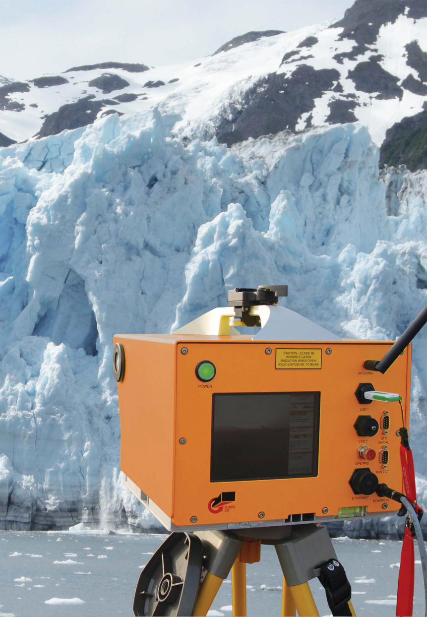
Facing page: ILRIS-LR Long Range Laser Scanner

Complete Solutions for Today’s Surveyor
Optech's ILRIS Laser Scanner enables surveyors to capture and define the world point by point. From single to multiple scans, you can
coordinate and document your subject in 3 dimensions. An ideal complement to a surveyor's tool-kit, the ILRIS brings high-density
engineering and survey-grade data to the table at amazingly high data collection rates.

GEOLOGICAL SURVEY
CIVIL ENGINEERING
MINE PLANNING
IN-MOTION SCAN
ILR
IS L
AS
ER
SC
AN
NE
R
Optech’s ILRIS-LR Laser Scanner has more range capability than any other tripod-based laser scanner. Additionally, the ILRIS-LR’s design
enables surveyors to scan ice, snow and wet surfaces with the same high accuracy and precision as other ILRIS models.
Complete Solutions for Long Range Surveying

Applications
• Rock fall monitoring and analysis
• Change detection
• Outcrop data collection and modeling
When scanning geological features, range, accuracy and precision are the key
differentiators that set the ILRIS apart. This compact, portable laser scanner is field-ready.
Its modular design enables you to plan an expedition, taking only the essential
components for each particular journey.
ILRIS in Geology
Yosemite National ParkGlacier Point
37°43’38.66”N
119° 33’54.24”W
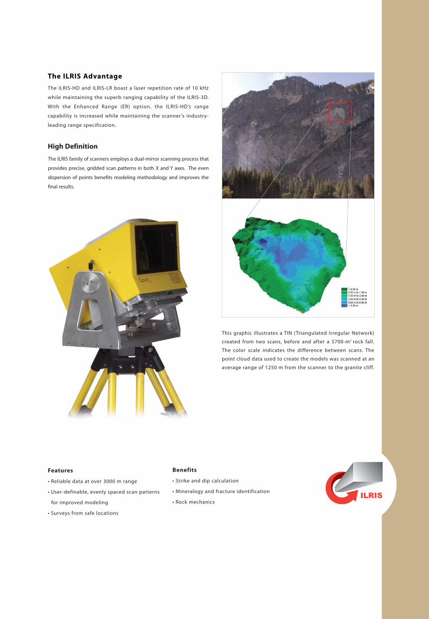
The ILRIS Advantage
The ILRIS-HD and ILRIS-LR boast a laser repetition rate of 10 kHz
while maintaining the superb ranging capability of the ILRIS-3D.
With the Enhanced Range (ER) option, the ILRIS-HD’s range
capability is increased while maintaining the scanner's industry-
leading range specification.
High Definition
Features
• Reliable data at over 3000 m range
• User-definable, evenly spaced scan patterns
for improved modeling
• Surveys from safe locations
Benefits
• Strike and dip calculation
• Mineralogy and fracture identification
• Rock mechanics
This graphic illustrates a TIN (Triangulated Irregular Network)
created from two scans, before and after a 5700-m3 rock fall.
The color scale indicates the difference between scans. The
point cloud data used to create the models was scanned at an
average range of 1250 m from the scanner to the granite cliff.
The ILRIS family of scanners employs a dual-mirror scanning process that
provides precise, gridded scan patterns in both X and Y axes. The even
dispersion of points benefits modeling methodology and improves the
final results.

Applications
• Construction verification (as built)
• Inspection tool
• Engineering tool—volumes, surface
calculations, spatial dimensioning
With the ILRIS Laser Scanner, high-definition scanning has never been easier and faster.
Instrument orientation and position are measured or established with standard survey
practices. These parameters can be entered into the scanner, enabling point cloud
alignment and registration in the field—no need to return to the office for post-
processing. Accurate dimensions can now be extracted directly from the point cloud,
permitting immediate construction or assembly verification—no more long delays for
extensive data processing time.
ILRIS in Civil Engineering
43°47’39.35”N
79° 32’23.93”W
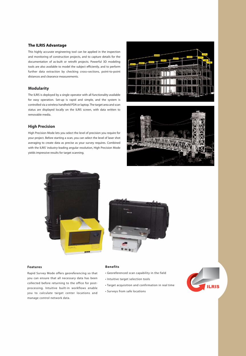
Features
Rapid Survey Mode offers georeferencing so that
you can ensure that all necessary data has been
collected before returning to the office for post-
processing. Intuitive built-in workflows enable
you to calculate target center locations and
manage control network data.
Benefits
• Georeferenced scan capability in the field
• Intuitive target selection tools
• Target acquisition and confirmation in real time
• Surveys from safe locations
The ILRIS Advantage
This highly accurate engineering tool can be applied in the inspection
and monitoring of construction projects, and to capture details for the
documentation of as-built or retrofit projects. Powerful 3D modeling
tools are also available to model the subject efficiently, and to perform
further data extraction by checking cross–sections, point-to-point
distances and clearance measurements.
Modularity
The ILRIS is deployed by a single operator with all functionality available
for easy operation. Set-up is rapid and simple, and the system is
controlled via a wireless handheld PDA or laptop. The target area and scan
status are displayed locally on the ILRIS screen, with data written to
removable media.
High Precision
High Precision Mode lets you select the level of precision you require for
your project. Before starting a scan, you can select the level of laser shot
averaging to create data as precise as your survey requires. Combined
with the ILRIS' industry-leading angular resolution, High Precision Mode
yields impressive results for target scanning.
24°16’37.25”S
69° 4’14.29”W
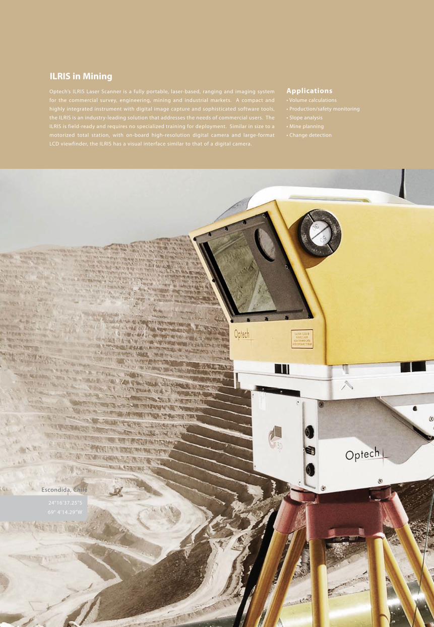
Applications
• Volume calculations
• Production/safety monitoring
• Slope analysis
• Mine planning
• Change detection
Optech’s ILRIS Laser Scanner is a fully portable, laser-based, ranging and imaging system
for the commercial survey, engineering, mining and industrial markets. A compact and
highly integrated instrument with digital image capture and sophisticated software tools,
the ILRIS is an industry-leading solution that addresses the needs of commercial users. The
ILRIS is field-ready and requires no specialized training for deployment. Similar in size to a
motorized total station, with on-board high-resolution digital camera and large-format
LCD viewfinder, the ILRIS has a visual interface similar to that of a digital camera.
ILRIS in Mining
Escondida, Chile

The ILRIS Advantage
The ILRIS-HD and ILRIS-LR boast a true measurement rate of 10
kHz while maintaining the superb ranging capability of ILRIS-3D.
With higher data collection rates and unmatched range and
angular accuracies, the ILRIS delivers extremely precise point
clouds for modeling and processing.
Rapid Surveys
Rapid Survey Mode offers georeferencing, resection and back-
sight functionality, dramatically reducing data collection and
post-processing times. In this mode, the ILRIS controller
automatically calculates the georeferenced positions of all scans
from its location. It also provides direct real-time confirmation of
each scanned target, which the operator can accept or reject
based on the resulting data quality.
Features
Using traditional dual–axis scanning mode and
area–of–interest scan selection techniques, the
scanner’s efficiency is 100%—all laser shots are
aimed at the selected targets.
Benefits
• Georeferenced scan capability in the field
• Fewer scanner set–ups required for the same
scan coverage
• Surveys from safe locations

Applications
• Shoreline mapping
• Harbor entrances• Navigation features and obstacles
• Coastal mapping
Optech's ILRIS Motion Compensation feature enables the collection of precise dynamicmotion-compensated 3D data sets from a moving platform. When integrated with an INSsystem, ILRIS Motion Compensation delivers georeferenced data sets for a multitude ofapplications. Boats, off-road vehicles and airships are now suitable platforms to scan whatyou have never been able to scan before.
ILRIS in Mobile Scanning
Photo courtesy of Port of London Authority and NetSurvey Limited

Features
• Integration with most existing INS systems
• Data can be combined with bathymetric scans
• Scan continuously with bathymetric systems
Benefits
• Dynamic scanning ranges beyond 1500 m
• Intuitive boresight software
• Georeferenced scan capability in the field
The ILRIS Advantage
The ILRIS can perform Motion Compensation with either dual-axis or single-
axis scanning. In single-axis scanning—the more traditional method—the
ILRIS is oriented at 90° to the platform’s direction of travel, and scans while the
platform is moving. The ILRIS captures data along the Y-axis using only one
mirror, but the motion of the platform enables it to capture data along the X-
axis as well. As a result, objects beside the scanning platform are scanned as
the ILRIS moves past the areas of interest.
Moving Platforms
ILRIS Motion Compensation also uses dual-axis (step and stare)scanning to collect survey-grade data even on unstable platformssuch as moored watercraft. In dual-axis scanning, the ILRIS uses bothmirrors to scan the X- and Y-axes, while ILRIS Motion Compensationcorrects for any swaying of the platform. The ILRIS also employs thisfeature when calibrating and synchronizing the scanner with the INSsystem.
Off-road vehicles and airships are suitable mobile platforms to perform scans
of areas that were previously very difficult or impossible to survey.
Photo courtesy of CC & E - Coastal Consulting and Exploration

Power Options
ILRIS PortableField Power
The availability and reliability offield power in remote locationsare key elements to efficiency thatcannot be overlooked. The ILRISbattery/charging system sharesthe same technology that hasbeen adopted worldwide by videoand broadcast professionals.
Robust and Modular
Battery System
• Two batteries provide a scantime of approximately 2.5hours
• Hot-swap capability to changebatteries without interruptingscanner operation
• Uses as many pairs of batteriesas required
• Easy to transport, set up andre-pack
• Used anywhere with universal85-265 VAC, 50/60-Hz operation
Economical Operationfrom Line AC
• Compact, rugged universalinput voltage (85-256 VAC,50/60 Hz) for operation whereAC mains are available
System Features
Eye safety
• Class 1 laser, eye-safe in all ranges and conditions
• CDRH, US FDA and IEC Class 1
• ILRIS-LR is a Class 3 laser
Product Approvals
The ILRIS carries Class 1 laser safetyapproval as well as a CE marking. Theunit has passed the most stringenttests for EMC (radiated andimmunity) as carried out by anindependent testing authority(Canadian Standards Association).The unit is also sealed for operation
Multi-Purpose
The ILRIS is the most versatile scanning system of its kind:
• Cross-deployable over a wide range ofapplications and industries
• Convenient to use
• Quick to set up in any environment
Dual battery charger
Sturdy backpack
Convenient andeasy-to-use traveling case
Battery and holder
AC power supply,shown with a penny
ILRIS-36D
The ILRIS-36D offers panning and tilting capability with a motorized base that is seamlessly controlledthrough the ILRIS user interface. The standard 400 x 400 field of view is extended to a full 3600 x 3600 withno loss of accuracy or functionality. This option also includes Profile Scan Mode. By controlling therotational speed of the pan/tilt base and scanning in the vertical axis only, the ILRIS-36D performs acomplete or selected portion of a 3600 scan that is saved in a single scan file.
in wet and damp locations.

CN Tower, Toronto, CanadaHeight: 553 m
About Optech
Optech is the world leader in the development, manufacture and
support of advanced lidar and imaging-based survey instruments.
With operations and staff worldwide, Optech offers both standalone
and fully integrated lidar and camera solutions in airborne terrestrial
mapping, airborne laser bathymetry, mobile mapping, mine cavity
monitoring, and industrial process control, as well as space-proven
sensors.
Optech Incorporated300 Interchange Way
Vaughan, ON
Canada L4K 5Z8
Tel: +1 905 660 0808
Fax: +1 905 660 0829
www.optech.ca
© Optech Incorporated. E&OE. Information subject to change without notice. Printed in Canada. 100908
Top Related