


Languages
Pages
Legal


THE PHYSICAL LANDSCAPE | EXPLORE OUR NATURAL WORLD: A BIODIVERSITY ATLAS OF THE LAKE HURON TO LAKE ERIE CORRIDOR 76 EXPLORE OUR NATURAL WORLD: A BIODIVERSITY ATLAS OF THE LAKE HURON TO LAKE ERIE CORRIDOR | THE PHYSICAL LANDSCAPE
The Ice Age
For the last two million years, Earth hasbeen in an ice age, characterized by twoalternating climatic states known as glacial periods and interglacial periods.
During glacial periods, our planet cooled.Giant sheets of ice expanded and covered30 percent of the land located at mid tohigh latitudes in the NorthernHemisphere. These cold, dry glacial periods lasted about 100,000 years.
Interglacial periods begin when Earthabruptly warms and the ice sheets melt.Warm, moist conditions allow soils todevelop and life to return to the terrain.Interglacial periods are relatively brief,typically lasting 10,000 to 15,000 years.North America’s most recent glacial
period is called the Wisconsin Stage. It began about 110,000 years agoand ended about 10,000 years agowhen the Holocene Epoch began.During the peak of the WisconsinStage about 20,000 years ago, icecompletely covered what is now theGreat Lakes Basin. The southernedge, or terminus, of this ice sheetextended as far south as the OhioRiver.
For the last 10,000 years the Earthhas been in a warm interglacial period known as the HoloceneEpoch. The timing of natural cycles suggests the Earth shouldagain be heading back to a cold glacial period within the next several thousand years.
The Lake Huron to Lake Erie Corridor’spresent physical landscape has been profoundly affected by a remarkable geologic event - an ice age. Long ago,glaciers more than a mile (1.6 km) thickcovered the entire Great Lakes Region.As they moved from north to south, theglaciers picked up and carried sedimentsand bedrock, then deposited them toshape landforms throughout the region.
Geologists have studied these landformsas well as sediment types, erosional features and fossils to piece together this area’s glacial history. Their findingsreveal the crucial role that ice played inthe evolution of the biodiversity thatexists today.
TH E PH Y S I C A L LA N D S C A PE
eologically, the Great Lakes ecosystem is very young and can be thought of
as an evolutionary laboratory.”– The Nature Conservancy
Glacial Processes, Landformsand Sediment Types
In 1840, the famous naturalist Louis Agassiz was one of the first tochampion the concept of an ice age.From observations of the processes,landforms and sediments associatedwith modern mountain glaciers,Agassiz concluded that massive continental ice sheets once existed in Scandinavia and all of northernEurope. The theory that the present isthe key to the past is called actualism.It is an important philosophical concept used by geologists to unravelEarth’s history. By mapping glacialgrooves, sediment types and landforms, geologists can reconstructthe former extent and flow of theancient continental ice sheets thatonce covered the Great Lakes Basin.This type of study provides a linkbetween the ice age theory originallydescribed by Agassiz in Europe andthe glacial history that defines thelandscape of southeastern Michiganand southwestern Ontario.
Glaciers Leave Tracks
Glaciers create unique landforms, sediment types and erosional patterns.They also carry rocks of all sizes forgreat distances. Many of the glacialrocks found in the Lake Huron toLake Erie Corridor came from theCanadian Shield north of LakeHuron. These relocated rocks arecalled glacial erratics. Their surfacescommonly have grooves and facetsfrom being scraped under the ice. The shearing and abrasion by therock-studded ice also grooves theunderlying land surface.
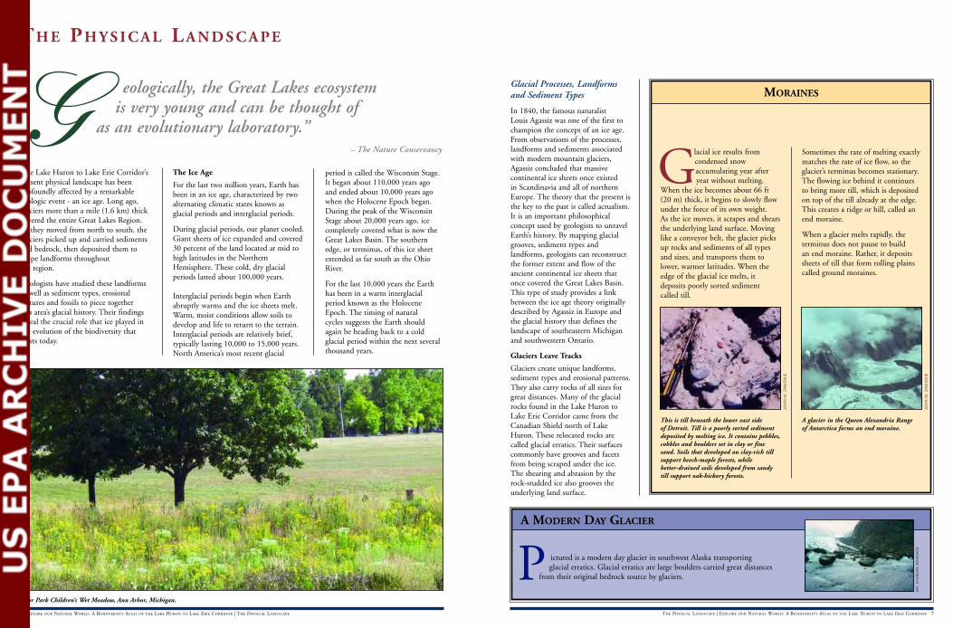
“ GMORAINES
This is till beneath the lower east side of Detroit. Till is a poorly sorted sedimentdeposited by melting ice. It contains pebbles,cobbles and boulders set in clay or finesand. Soils that developed on clay-rich tillsupport beech-maple forests, while better-drained soils developed from sandytill support oak-hickory forests.
Buhr Park Children’s Wet Meadow, Ann Arbor, Michigan.
A glacier in the Queen Alexandria Rangeof Antarctica forms an end moraine.
Sometimes the rate of melting exactlymatches the rate of ice flow, so theglacier’s terminus becomes stationary.The flowing ice behind it continuesto bring more till, which is depositedon top of the till already at the edge.This creates a ridge or hill, called anend moraine.
When a glacier melts rapidly, the terminus does not pause to build an end moraine. Rather, it depositssheets of till that form rolling plainscalled ground moraines.
ictured is a modern day glacier in southwest Alaska transporting glacial erratics. Glacial erratics are large boulders carried great distances
from their original bedrock source by glaciers. PA MODERN DAY GLACIER
JOH
N M
. Z
AW
ISK
IE
JOH
N M
. Z
AW
ISK
IE
DR
. S
HA
RO
N J
OH
NS
ON
lacial ice results from condensed snow accumulating year afteryear without melting.
When the ice becomes about 66 ft(20 m) thick, it begins to slowly flowunder the force of its own weight. As the ice moves, it scrapes and shearsthe underlying land surface. Movinglike a conveyor belt, the glacier picksup rocks and sediments of all typesand sizes, and transports them tolower, warmer latitudes. When theedge of the glacial ice melts, itdeposits poorly sorted sediment called till.
G
THE PHYSICAL LANDSCAPE | EXPLORE OUR NATURAL WORLD: A BIODIVERSITY ATLAS OF THE LAKE HURON TO LAKE ERIE CORRIDOR 98 EXPLORE OUR NATURAL WORLD: A BIODIVERSITY ATLAS OF THE LAKE HURON TO LAKE ERIE CORRIDOR | THE PHYSICAL LANDSCAPE
Glacial Lakes
Large glacial lakes are created bywater that has ponded between theice front and the previously formedend moraines. Sediments depositedin deeper parts of glacial lakes aretypically fine-grained clay and silt.Sand and gravel usually are depositedin long ridges in near-shore sandbars,along beaches and in coastal dunes.
As water drains from a glacial lake, it leaves a flat lakeplain with beachridges, channels and wave-cut terraces. The topography of EssexCounty, Ontario, exemplifies the flat landscape left by glacial lakes.
Water-lain moraines are low-lyinglandforms that develop where the ice meets the glacial lake. In theCorridor, water-lain moraines on the
(Left) Lacustrine clay and silt are sedimentsdeposited in glacial lakes. The soils that laterformed on these deposits are poorly-drainedand, generally, support hardwood swamp forests and lakeplain prairie.
A sandy beach ridge with wide-spreading oaktrees lies parallel to the Detroit River shorelinein Brownstown Township, Michigan. Pioneercemeteries often were built on the sandy ridgesleft by ancient glacial lakes.
Kames
Kames are low hills of layered sand andgravel deposited by glacial melt-water.These sediments could come fromstreams that flow beneath the glacier and emerge as a delta at the ice front, or from river and lake sediments deposited on top of the glacier.
Kettle
Sometimes a block of melting icedetaches from the glacier and is lefton the outwash plain where itbecomes buried by sediments. Whenthe ice block melts, it forms a kettledepression, which often fills withmelt-water or groundwater andbecomes a lake. Kettle lakes andkames commonly are both found
on ground moraines;together they formkettle and kametopography. A goodexample of this is atStony CreekMetropark nearRochester, Michigan.
The low hills in the center of the photo are kames in Greenland.
GroundMoraine
Retreating Ice Sheet
Esker
Outwash Plan
Ground Moraine
L A N D F O R M S C R E AT E D BY G L A C I E R S
In some cases, long, winding rivers flow in tunnels beneath a glacier. Sediments depositedinto these tunnels form ridges of layered sandand gravel that are left behind when the glacier recedes. These landforms are calledeskers. The yellow highlighted portion in theaerial photograph above is an esker in Oakland County, Michigan.
End Moraine
Outwash
Kettle Lakes
RecessionalMoraine
Stream
ENVIRONMENTS IN FRONT OF GLACIERSU
SG
S D
IGIT
AL
DA
TA S
ER
IES
DD
52
1
(INSET) NATURAL RESOURCES CANADA, TERRAIN SCIENCES DIVISION, CANADIAN LANDSCAPES
BA
LTH
AZ
AR
KO
RA
B
TH
OM
AS
LO
WE
LL
OA
KL
AN
D C
OU
NT
Y P
LA
NN
ING
& E
CO
NO
MIC
DE
VE
LO
PM
EN
T S
ER
VIC
ES
Landforms Beneath Glaciers: Eskers
away from the glacier. Theydeposit the sediments in well-sorted sheets of sand and gravel.These deposits are called outwash.
The great amount of melt-waterreleased by glaciers can result in theformation of rivers in front of theice. These rivers carry sediments
Outwash is well-sorted sand and graveldeposited by braided streams. The examplefeatured above was photographed beneaththe Cranbrook Institute of Science inBloomfield Hills, Michigan. This type of sediment is found in outwash plains,kames and eskers. Outwash deposits evolve into extremely well-drained soilswhich, on uplands, support oak barren, woodland and prairie communities.
Pictured is the Exit Glacier in Alaskawith moraine and outwash plain(stream deposits.)
(Above inset) A kettle lake ringed by sprucetrees and permafrost patterned ground inthe Hudson Bay lowlands of Canada.
lakeplain were eroded by the glacial lakesand are not easy to identify today. The cities of Mt. Clemens, Detroit andWindsor were built on the Detroit water-lain moraine. The LeamingtonMoraine is only visible as a high knob
west of Leamington,Ontario. Farther east,Ridgetown, Ontario,was named for themorainal deposits on which it sits.Aboriginal peopleand pioneers traveledalong these morainesbecause they support-
ed forests that were easier to traverse thanthe surrounding swamps of the lakeplain.One route used by pioneers was theTalbot Trail, which followed a morainefrom Essex to Ridgetown, Ontario.
DR
. J.
BR
IGH
AM
-GR
ET
TE

The Great Lakes were not always as we know them today. Their basins were formed by glacial
erosion of pre-existing river valleys, which then filled with melt-water. The lakes have since evolved in
shape, size and even the direction in which their waters flow.
14,000 years before present: Glaciers formed the Defiance Moraine atthe edge of the Huron-Erie Lobe. When the ice melted back from thislocation, Lake Maumee formed. The lake subsequently changed inshape and size, and created an expansive lakeplain in southeasternMichigan and southwestern Ontario. A series of water-lain morainesformed in the lakeplain as the ice front receded. They include theDetroit, Mt. Clemens, Emmet and southern portion of the Port HuronMoraines in Michigan, and the Wyoming, Leamington and BlenheimMoraines in Ontario.
14,500 years before present: Four glacial lobescovered what is now most
of Michigan and all ofOntario. The retreating
ice front paused and builtthe Valparaiso, Charlotte
and Fort WayneMoraines. When the
glacial lobes retreated farther, the first glacial
lakes began to form.
13,000 years before present: The receding glaciers made a strong readvance. This ice front built the region’s most prominent topographicfeature, the Port Huron Moraine, which extends almost continuouslyfrom Minnesota to New York. Lake Whittlesey, the largest glacial lake to occupy the region, also was formed during this stage. Later, a combination of retreating and re-advancing ice created a series of glacial lakes, each with a different outline and elevation, whichoccupied parts of the lakeplain area until 11,000 years ago. Due to erosion, only the former shorelines of lakes Maumee, Whittlesey, and Warren can be easily recognized today in the form of low, continuous, sandy ridges within a few kilometers of the Lake Huron to Lake Erie Corridor’s shorelines.
11,000 years before present: The beginning of the Lake AlgonquinStage. Waters drained south to early Lake Erie, cutting the initialchannels of the St. Clair River and Detroit River.
9,500 years before present: As the ice front retreated, Great Lakes waterbegan draining into northern Ontario rather than through the St.Clair and Detroit Rivers, resulting in extremely low lake levels. Forestsgrew on the exposed lakebeds. Evidence of this stage can be found indrowned forests on the floor of Lake Huron today.
6,000 to 4,000 years before present: The Lake Nipissing Stage. Themodern drainage patterns of the Great Lakes were established after thelast remaining glacial ice retreated toward Canada’s northern latitudes.With the ice burden gone, land in the northern part of the regionbegan to rise (a phenomenon known as isostatic rebound), which cut off the North Bay outlet. Downcutting of the St. Clair River loweredlake levels and shut off the Chicago outlet. The Lake Huron to LakeErie Corridor has remained the dominant outlet for the upper GreatLakes since then.
T H E G L A C I A L H I S T O R Y O F T H E L A K E H U R O N T O L A K E E R I E C O R R I D O R
This terminus of a Greenland ice
sheet is what PortHuron, Michigan,
and Sarnia,Ontario, may
have looked like13,000 years ago.
T H E G R E AT L A K E S 1 4 , 5 0 0 Y E A R S A G O T H E G R E AT L A K E S 1 4 , 0 0 0 Y E A R S A G O
T H E G R E AT L A K E S 1 3 , 0 0 0 Y E A R S A G O
As the Earth warmed and the ice began toquickly retreat, the space between the Saginaw
Lobe and the Huron-Erie Lobe widened, whichcaused a seam, or an “interlobate” area to open.
Deposited within the interlobate area were aseries of outwash plains with numerous kames,
eskers, and kettle lakes flanked by morainesmade of till from both lobes. The drawings
to the right show the development of the interlobate area between the Huron
and Saginaw Lobes between 14,500 to 13,800years ago.
INTERLOBATE AREA
BETWEEN THE SAGINAW
AND HURON-ERIE LOBE
THE GREAT LAKES 11,000 YEARS AGO
THE GREAT LAKES 9,500 YEARS AGO
THE GREAT LAKES 6,000-4,000 YEARS AGO
SOURCE OF GLACIAL POSITIONILLUSTRATIONS:
FARRAND, W.R. AND KELLYR.W., 1967 REPRINTED 1987,
THE GLACIAL LAKESAROUND MICHIGAN.
BULLETIN N0. 4, PUBLISHEDBY THE MICHIGANDEPARTMENT OF
ENVIRONMENTAL QUALITY,GEOLOGICAL SURVEY
DIVISION
ICE FRONT POSITIONS FROM TWENTER AND KNUTILLA, 1972
SA
ND
Y S
HIP
LE
12 EXPLORE OUR NATURAL WORLD: A BIODIVERSITY ATLAS OF THE LAKE HURON TO LAKE ERIE CORRIDOR | THE PHYSICAL LANDSCAPE
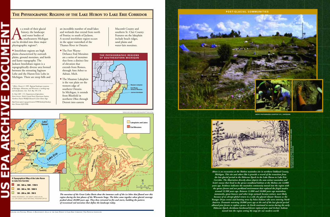
s a result of their glacial history, the landscape and water bodies of southeastern Michigan
can be divided into three majorphysiographic regions*:
• Interlobate regions are high plains characterized by outwashplains, ground moraines, and kettleand kame topography. The Jackson Interlobate region is a topographically diverse area formedbetween the retreating Saginaw Lobe and the Huron-Erie Lobe inMichigan. There are steep hills and
The moraines of the Great Lakes Basin show the immense scale of the ice lobes that flowed over thisregion during the late phases of the Wisconsin Stage. The lobes came together when glacial coveragepeaked about 20,000 years ago. They then retreated in fits and starts, building the pattern of recessional end moraines that define the landscape today.
an incredible number of small lakes and wetlands that extend from north of Pontiac to south of Jackson. A second interlobate region occurs in the upper watershed of the Thames River in Ontario.
• The Fort Wayne-Defiance End Morainesare a series of morainesthat form a distinct lineof elevation thatextends from Romeo,through Ann Arbor toAdrian, Mich.
• The Maumee Lakeplainis the vast plain on thewestern edge of southern Ontario. In Michigan, it extendsfrom Blissfield in northern Ohio throughDetroit into eastern
Above is an excavation at the Shelton mastodon site in northern Oakland County,Michigan. This site and others like it provide a record of the transition from the late glacial period to the Holocene Epoch in the Lake Huron to Lake Erie
Corridor. The illustration directly above depicts the now-extinct mastodon andScott’s moose that lived in the spruce woodland habitat at the Shelton site 12,000years ago. Evidence indicates the mastodon community moved into the region withthe spruce forests and wet parkland environment that replaced the frigid tundra
around 12,500 years ago. Between 11,000 and 10,000 years ago mastodons, mammoths, giant beavers and other large animals became extinct, most likelybecause of an abrupt global return to a cold, dry glacial climate (known as the
Younger Dryas event) and hunting stress by Paleo-Indians who were entering NorthAmerica. Dramatic warming 10,000 years ago at the end of the last glacial period
allowed pine forests to replace spruce. As Earth continued to warm during the earlyHolocene Epoch, deciduous hardwood forests replaced pine and Archaic Indians
moved into the region setting the stage for our modern world.
THE PHYSIOGRAPHIC REGIONS OF THE LAKE HURON TO LAKE ERIE CORRIDOR
* Albert, Dennis A. 1995. Regional landscape ecosystems of Michigan, Minnesota, and Wisconsin: a working map and classification. Gen. Tech. Rep. NC-178.
St. Paul, MN: U.S. Department of Agriculture, Forest Service, North Central Forest Experiment Station. Northern Prairie Wildlife Research Center Home Page.
http://www.npwrc.usgs.gov/resource/1998/rlandscp/rlandscp.htm (Version 03JUN98).
A Macomb County and southern St. Clair County.Features on the lakeplaininclude beach ridges, sand plains and water-lain moraines.
A Topographical Map of the Lake Huron to Lake Erie Corridor
300 - 500 m, 1000 - 1700 ft
200 - 300 m, 700 - 1000 ft
100 - 200 m, 300 - 700 ft
WWW.GEO.MSU.EDU/GEO333/PART-TWO.HTML
IMAGE REFERENCE: THE GREAT LAKES ATLAS,U.S. EPA GREAT LAKES NATIONAL PROGRAM OFFICE
ABOVE PHOTOGRAPHS COURTESY OF J. SHOSHANI
ILL
US
TR
AT
ION
AR
TW
OR
K B
Y M
AR
GA
RE
T P
UR
VE
S U
ND
ER
TH
E D
IRE
CT
ION
OF
J.
SH
OS
HA
NI
T H E P H YS I O G R A P H I C R E G I O N S
O F S O U T H E A S T E R N M I C H I G A N
P O S T- G L A C I A L C O M M U N I T I E S
14 EXPLORE OUR NATURAL WORLD: A BIODIVERSITY ATLAS OF THE LAKE HURON TO LAKE ERIE CORRIDOR | THE PHYSICAL LANDSCAPE
loamy and clay soils that evolvedfrom deposits of fine silts and claysleft by the glacial lakes. Hardwoodswamps normally occupy the flat,poorly-drained lakeplain. Howeverthis lakeplain also has ancient beaches and sand deposits that support tallgrass prairie and oaksavanna. The development of soilsalso can be affected by the glaciallandforms upon which they are built.For example, soils found at the topof a hill are different from thosefound at its base. Topography, climate and vegetation all affect the development of soils over time.
Climate
The Great Lakes influence the climate of the Lake Huron to LakeErie Corridor. The lakes moderateconditions on the land around thembecause their water warms and coolsmore slowly than inland areas inresponse to temperature changes.This results in a relatively long annual frost-free growing period of 160 to 180 days per year.
Average July temperatures rangefrom 68 to 77 ºF (20 to 25 ºC) and average January temperaturesrange from 18.5 to 27.5 ºF (-7.5 to -2.5 ºC.) Precipitation averages 23.6 to 27.6 in (600 to 700 mm) per year.
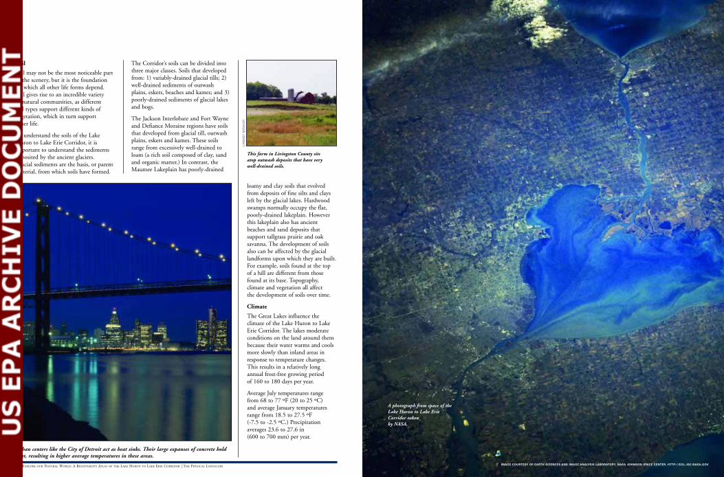
This farm in Livingston County sits atop outwash deposits that have very well-drained soils.
A photograph from space of theLake Huron to Lake ErieCorridor taken by NASA.
Urban centers like the City of Detroit act as heat sinks. Their large expanses of concrete holdheat, resulting in higher average temperatures in these areas.
Soil
Soil may not be the most noticeable partof the scenery, but it is the foundation on which all other life forms depend. Soil gives rise to an incredible variety of natural communities, as different soil types support different kinds of vegetation, which in turn support other life.
To understand the soils of the LakeHuron to Lake Erie Corridor, it isimportant to understand the sedimentsdeposited by the ancient glaciers. Glacial sediments are the basis, or parent material, from which soils have formed.
RO
BE
RT
ST
EW
AR
T
LIN
DS
EY
MIS
HL
ER
IMAGE COURTESY OF EARTH SCIENCES AND IMAGE ANALYSIS LABORATORY, NASA JOHNSON SPACE CENTER, HTTP://EOL.JSC.NASA.GOV
The Corridor’s soils can be divided intothree major classes. Soils that developedfrom: 1) variably-drained glacial tills; 2)well-drained sediments of outwashplains, eskers, beaches and kames; and 3)poorly-drained sediments of glacial lakesand bogs.
The Jackson Interlobate and Fort Wayneand Defiance Moraine regions have soilsthat developed from glacial till, outwashplains, eskers and kames. These soilsrange from excessively well-drained toloam (a rich soil composed of clay, sandand organic matter.) In contrast, theMaumee Lakeplain has poorly-drained
THE PHYSICAL LANDSCAPE | EXPLORE OUR NATURAL WORLD: A BIODIVERSITY ATLAS OF THE LAKE HURON TO LAKE ERIE CORRIDOR 17
spreads into several channels that windaround its many islands. The river gradually widens to more than 3.75 miles(6 km) as it empties into Lake Erie. Thenatural depth of the Detroit River rangesfrom 20 to 25 ft (6 to 7.6 m). Its flowrate is similar to that of the St. ClairRiver. On average, it takes about 20hours for water to travel from Lake St. Clair to Lake Erie.
Construction of the St. Lawrence Seaway system in the 1950s resulted in creation of commercial navigationchannels that altered the depth of theLake Huron to Lake Erie Corridor. Inthe late-1950s, a 28 ft (8.3 m) channelwas created in the St. Clair River, followed by one in Lake St. Clair. The channel through the Detroit Riverwas completed in 1969.
The Detroit River is 32 mi (51 km)long, of varying width and occupiedby numerous islands. Near the headof the river at Lake St. Clair are Belle Isle and Peche Island. From these islands, water flows along a single channel whose widthranges from 2,333 to 3,333 ft (700 to 1,000 m). In the lowerDetroit River, the water flow
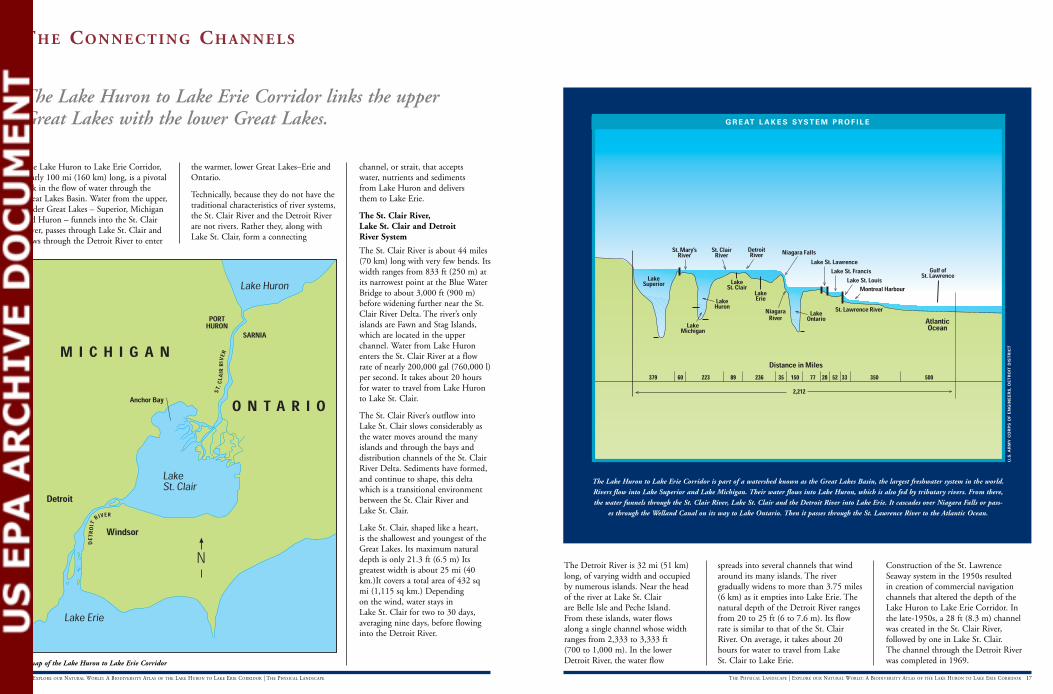
The Lake Huron to Lake Erie Corridor is part of a watershed known as the Great Lakes Basin, the largest freshwater system in the world.
Rivers flow into Lake Superior and Lake Michigan. Their water flows into Lake Huron, which is also fed by tributary rivers. From there,
the water funnels through the St. Clair River, Lake St. Clair and the Detroit River into Lake Erie. It cascades over Niagara Falls or pass-
es through the Welland Canal on its way to Lake Ontario. Then it passes through the St. Lawrence River to the Atlantic Ocean.
G R E AT L A K E S SYS T E M P R O F I L E
U.S
.A
RM
Y C
OR
PS
OF
EN
GIN
EE
RS
,D
ET
RO
IT D
IST
RIC
T
16 EXPLORE OUR NATURAL WORLD: A BIODIVERSITY ATLAS OF THE LAKE HURON TO LAKE ERIE CORRIDOR | THE PHYSICAL LANDSCAPE
the warmer, lower Great Lakes–Erie andOntario.
Technically, because they do not have thetraditional characteristics of river systems,the St. Clair River and the Detroit Riverare not rivers. Rather they, along withLake St. Clair, form a connecting
channel, or strait, that accepts water, nutrients and sediments from Lake Huron and delivers them to Lake Erie.
The St. Clair River, Lake St. Clair and Detroit River System
The St. Clair River is about 44 miles(70 km) long with very few bends. Itswidth ranges from 833 ft (250 m) atits narrowest point at the Blue WaterBridge to about 3,000 ft (900 m)before widening further near the St.Clair River Delta. The river’s onlyislands are Fawn and Stag Islands,which are located in the upper channel. Water from Lake Huronenters the St. Clair River at a flowrate of nearly 200,000 gal (760,000 l)per second. It takes about 20 hoursfor water to travel from Lake Huronto Lake St. Clair.
The St. Clair River’s outflow intoLake St. Clair slows considerably asthe water moves around the manyislands and through the bays and distribution channels of the St. ClairRiver Delta. Sediments have formed,and continue to shape, this deltawhich is a transitional environmentbetween the St. Clair River and Lake St. Clair.
Lake St. Clair, shaped like a heart, is the shallowest and youngest of theGreat Lakes. Its maximum naturaldepth is only 21.3 ft (6.5 m) Itsgreatest width is about 25 mi (40km.)It covers a total area of 432 sqmi (1,115 sq km.) Depending on the wind, water stays in Lake St. Clair for two to 30 days,averaging nine days, before flowinginto the Detroit River.
The Lake Huron to Lake Erie Corridor,nearly 100 mi (160 km) long, is a pivotallink in the flow of water through theGreat Lakes Basin. Water from the upper,colder Great Lakes – Superior, Michiganand Huron – funnels into the St. ClairRiver, passes through Lake St. Clair andflows through the Detroit River to enter
A map of the Lake Huron to Lake Erie Corridor
TH E CO N N E C T I N G CH A N N E L S
The Lake Huron to Lake Erie Corridor links the upper Great Lakes with the lower Great Lakes.
THE PHYSICAL LANDSCAPE | EXPLORE OUR NATURAL WORLD: A BIODIVERSITY ATLAS OF THE LAKE HURON TO LAKE ERIE CORRIDOR 1918 EXPLORE OUR NATURAL WORLD: A BIODIVERSITY ATLAS OF THE LAKE HURON TO LAKE ERIE CORRIDOR | THE PHYSICAL LANDSCAPE
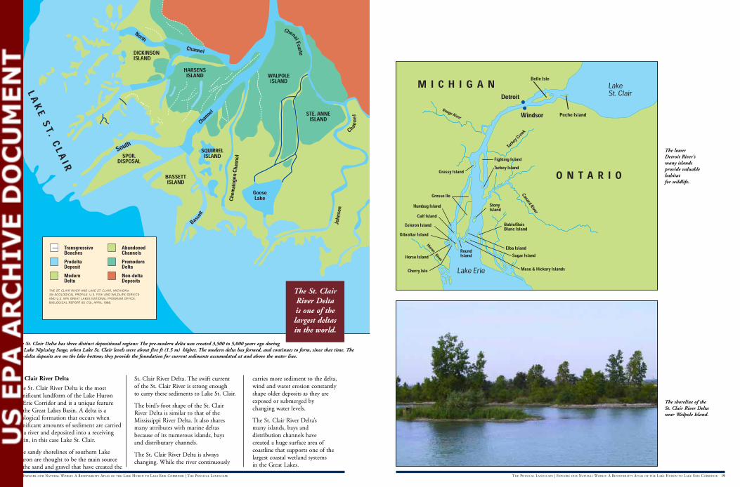
St. Clair River Delta. The swift currentof the St. Clair River is strong enough to carry these sediments to Lake St. Clair.
The bird’s-foot shape of the St. ClairRiver Delta is similar to that of theMississippi River Delta. It also sharesmany attributes with marine deltasbecause of its numerous islands, bays and distributary channels.
The St. Clair River Delta is alwayschanging. While the river continuously
carries more sediment to the delta,wind and water erosion constantlyshape older deposits as they areexposed or submerged by changing water levels.
The St. Clair River Delta’s many islands, bays and distribution channels have created a huge surface area of coastline that supports one of thelargest coastal wetland systems in the Great Lakes.
St. Clair River Delta
The St. Clair River Delta is the most significant landform of the Lake Huron to Erie Corridor and is a unique feature in the Great Lakes Basin. A delta is a geological formation that occurs when significant amounts of sediment are carriedby a river and deposited into a receivingbasin, in this case Lake St. Clair.
The sandy shorelines of southern LakeHuron are thought to be the main sourceof the sand and gravel that have created the
The St. Clair Delta has three distinct depositional regions: The pre-modern delta was created 3,500 to 5,000 years ago duringthe Lake Nipissing Stage, when Lake St. Clair levels were about five ft (1.5 m) higher. The modern delta has formed, and continues to form, since that time. Thepro-delta deposits are on the lake bottom; they provide the foundation for current sediments accumulated at and above the water line.
The lower Detroit River’s many islands provide valuable habitatfor wildlife.
The shoreline of the St. Clair River Delta near Walpole Island.
The St. Clair River Delta is one of the largest deltas in the world.
THE ST. CLAIR RIVER AND LAKE ST. CLAIR, MICHIGAN: AN ECOLOGICAL PROFILE. U.S. FISH AND WILDLIFE SERVICE AND U.S. EPA GREAT LAKES NATIONAL PROGRAM OFFICE, BIOLOGICAL REPORT 85 (7.3), APRIL 1988.
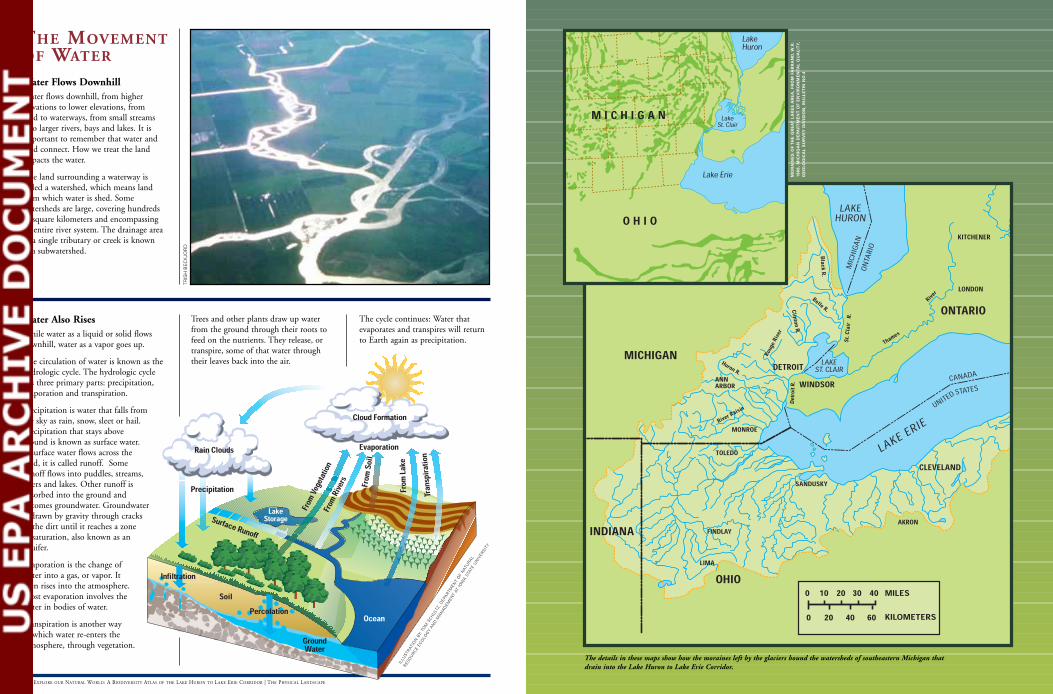
Water Flows DownhillWater flows downhill, from higher elevations to lower elevations, from land to waterways, from small streamsinto larger rivers, bays and lakes. It is important to remember that water andland connect. How we treat the landimpacts the water.
The land surrounding a waterway iscalled a watershed, which means landfrom which water is shed. Some watersheds are large, covering hundredsof square kilometers and encompassingan entire river system. The drainage areaof a single tributary or creek is known as a subwatershed.
The details in these maps show how the moraines left by the glaciers bound the watersheds of southeastern Michigan that drain into the Lake Huron to Lake Erie Corridor.
Water Also RisesWhile water as a liquid or solid flowsdownhill, water as a vapor goes up.
The circulation of water is known as thehydrologic cycle. The hydrologic cyclehas three primary parts: precipitation,evaporation and transpiration.
Precipitation is water that falls from the sky as rain, snow, sleet or hail.Precipitation that stays aboveground is known as surface water.If surface water flows across theland, it is called runoff. Somerunoff flows into puddles, streams,rivers and lakes. Other runoff isabsorbed into the ground andbecomes groundwater. Groundwateris drawn by gravity through cracksin the dirt until it reaches a zoneof saturation, also known as anaquifer.
Evaporation is the change ofwater into a gas, or vapor. Itthen rises into the atmosphere.Most evaporation involves thewater in bodies of water.
Transpiration is another way in which water re-enters the atmosphere, through vegetation.
Trees and other plants draw up waterfrom the ground through their roots tofeed on the nutrients. They release, ortranspire, some of that water throughtheir leaves back into the air.
The cycle continues: Water that evaporates and transpires will return to Earth again as precipitation.
THE MOVEMENTOF WATER
TRIS
H B
EC
KJO
RD
ILLU
STRA
TIO
N B
Y: T
OM
SCH
ULT
Z, D
EPAR
TMEN
T O
F N
ATU
RAL
RESO
URC
E EC
OLO
GY
AND
MAN
AGEM
ENT
AT IO
WA
STAT
E U
NIV
ERSI
TY
MO
RA
INE
S O
F T
HE
GR
EA
T L
AK
ES
AR
EA
,F
RO
M F
AR
RA
ND
,W
.R.
19
88
,M
ICH
IGA
N D
EP
AR
TM
EN
T O
F E
NV
IRO
NM
EN
TA
L Q
UA
LIT
Y,
GE
OL
OG
ICA
L S
UR
VE
Y D
IVIS
ION
,B
UL
LE
TIN
NO
.4
20 EXPLORE OUR NATURAL WORLD: A BIODIVERSITY ATLAS OF THE LAKE HURON TO LAKE ERIE CORRIDOR | THE PHYSICAL LANDSCAPE
22 EXPLORE OUR NATURAL WORLD: A BIODIVERSITY ATLAS OF THE LAKE HURON TO LAKE ERIE CORRIDOR | THE PHYSICAL LANDSCAPE
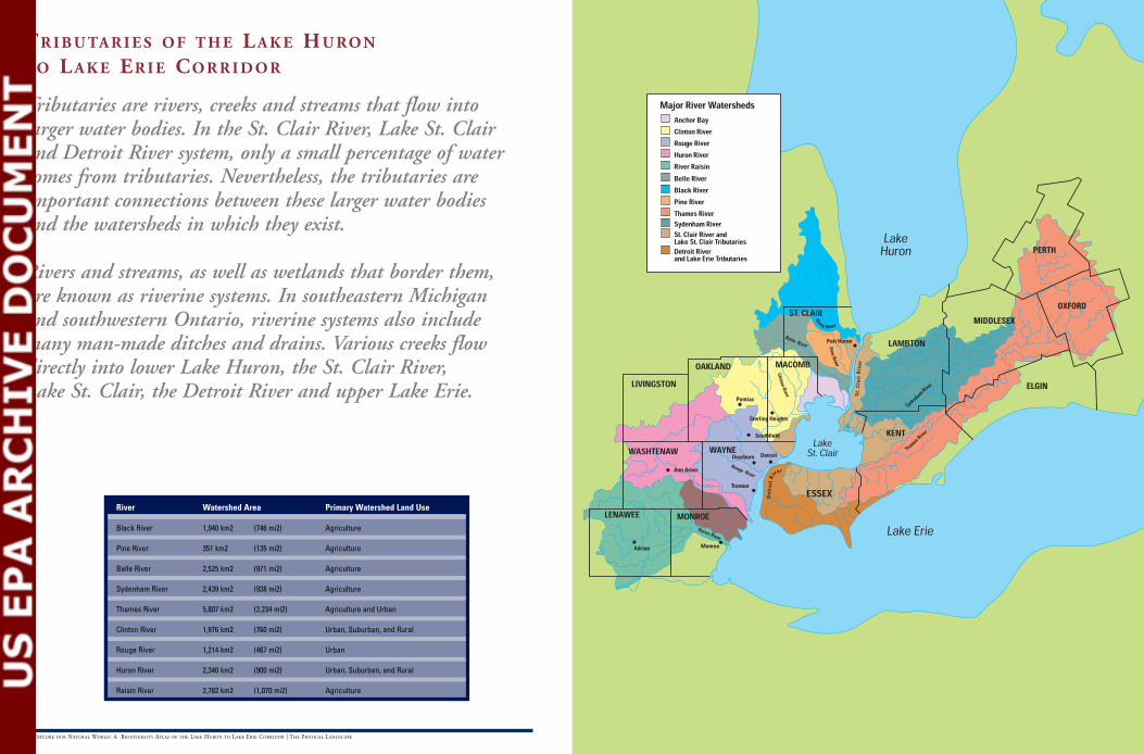
TR I B U TA R I E S O F T H E LA K E HU RO N
TO LA K E ER I E CO R R I D O R
Tributaries are rivers, creeks and streams that flow into larger water bodies. In the St. Clair River, Lake St. Clair and Detroit River system, only a small percentage of watercomes from tributaries. Nevertheless, the tributaries areimportant connections between these larger water bodies and the watersheds in which they exist.
Rivers and streams, as well as wetlands that border them, are known as riverine systems. In southeastern Michigan and southwestern Ontario, riverine systems also includemany man-made ditches and drains. Various creeks flowdirectly into lower Lake Huron, the St. Clair River, Lake St. Clair, the Detroit River and upper Lake Erie.
River Watershed Area Primary Watershed Land Use
Black River 1,940 km2 (746 mi2) Agriculture
Pine River 351 km2 (135 mi2) Agriculture
Belle River 2,525 km2 (971 mi2) Agriculture
Sydenham River 2,439 km2 (938 mi2) Agriculture
Thames River 5,807 km2 (2,234 mi2) Agriculture and Urban
Clinton River 1,976 km2 (760 mi2) Urban, Suburban, and Rural
Rouge River 1,214 km2 (467 mi2) Urban
Huron River 2,340 km2 (900 mi2) Urban, Suburban, and Rural
Raisin River 2,782 km2 (1,070 mi2) Agriculture
Top Related