


Languages
Pages
Legal


www.AppGeo.comSlide 1
ESRI & AutodeskESRI & Autodesk
Getting from here to thereGetting from here to there
and back againand back again

www.AppGeo.comSlide 2
OverviewOverview
Guido SteinGuido Stein
GIS AnalystGIS Analyst
Applied Geographics, Inc. (Boston)Applied Geographics, Inc. (Boston)
•• Technology ReviewTechnology Review
•• ApproachesApproaches
•• ConclusionsConclusions

www.AppGeo.comSlide 3
ProcessData Store
Information Products
Edit
Store
Use
GIS
Publish
Map
Output
Tables
Ref
Service
Ref
Data
Geodatabase

www.AppGeo.comSlide 4
Autodesk’s Approach to GISAutodesk’s Approach to GIS
•• Map 3D Classic ToolsMap 3D Classic Tools Import/export Shape Files into DWG drawing fileImport/export Shape Files into DWG drawing file
Object DataObject Data
Labeling using block templatesLabeling using block templates
•• Map 3D Feature Data Objects (FDO)Map 3D Feature Data Objects (FDO) Access GIS data using FDO connectionAccess GIS data using FDO connection
•• Including personal GeoDatabase and ShapefilesIncluding personal GeoDatabase and Shapefiles
Symbolize and organize FDO connections similarly to other Symbolize and organize FDO connections similarly to other GIS packagesGIS packages
Edit Shape FilesEdit Shape Files

www.AppGeo.comSlide 5
Autodesk’s Approach to GIS ConstraintsAutodesk’s Approach to GIS Constraints
•• Map 3D Classic ToolsMap 3D Classic Tools Cannot edit GIS data in placeCannot edit GIS data in place
Poor symbolization data toolsPoor symbolization data tools
•• Map 3D Feature Data Objects (FDO)Map 3D Feature Data Objects (FDO) FDO data do not work seamlessly with other CAD drawing FDO data do not work seamlessly with other CAD drawing
filesfiles
Only allow editing of shape file currentlyOnly allow editing of shape file currently

www.AppGeo.comSlide 6
ESRI’s Approach to CADESRI’s Approach to CAD
•• ArcGIS MapArcGIS Map Easily add DWG and Block Attributes to mapEasily add DWG and Block Attributes to map
•• ArcGIS for AutodeskArcGIS for Autodesk Map services as reference data within AutodeskMap services as reference data within Autodesk
OpenDWG attribute view/captureOpenDWG attribute view/capture
•• ArcGIS InfoArcGIS Info Export GIS data to NEW OpenDWG standardExport GIS data to NEW OpenDWG standard
•• Looks like a GDB from ArcCatalogLooks like a GDB from ArcCatalog
•• Retains AttributesRetains Attributes
•• Follows simple CAD Layer Name Standard for featuresFollows simple CAD Layer Name Standard for features

www.AppGeo.comSlide 7
ESRI’s Approach to CAD ConstraintsESRI’s Approach to CAD Constraints
•• ArcGIS MapArcGIS Map Can not read Object Data from Map3DCan not read Object Data from Map3D
•• ArcGIS for AutodeskArcGIS for Autodesk Attribute data cannot be used by Autodesk Map 3DAttribute data cannot be used by Autodesk Map 3D
•• ArcGIS InfoArcGIS Info Open DWG is not supported by AutodeskOpen DWG is not supported by Autodesk
•• Need to write custom code to accessNeed to write custom code to access
•• Can use ArcGIS for Autodesk (in CAD) to view and edit Can use ArcGIS for Autodesk (in CAD) to view and edit attributesattributes

www.AppGeo.comSlide 8
Example Situation: Glastonbury, CTExample Situation: Glastonbury, CT
GIS utility network integration with CADGIS utility network integration with CAD
CAD ResourcesCAD Resources•• Existing CAD expertise within staffExisting CAD expertise within staff
•• Existing CAD dataExisting CAD data hopefully in state plane feethopefully in state plane feet
•• Currently create/store/publish in CADCurrently create/store/publish in CAD
GIS objectivesGIS objectives•• Implementation of new GIS data modelImplementation of new GIS data model
Pick list for data, Geometric Network, Facility Asset Pick list for data, Geometric Network, Facility Asset Management Attributes collectedManagement Attributes collected
CONSTRAINTCONSTRAINT
•• Clients do not own Safe Soft FMEClients do not own Safe Soft FME

www.AppGeo.comSlide 9
Approach 1: CAD and GIS integrationApproach 1: CAD and GIS integration
Using OpenDWG data for native CAD editingUsing OpenDWG data for native CAD editing
ProcedureProcedure
•• Export to OpenDWG from GeodatabaseExport to OpenDWG from Geodatabase Retains attribute dataRetains attribute data
Viewable attributes using ArcGIS for AutodeskViewable attributes using ArcGIS for Autodesk
•• Import OpenDWG to GeoDatabaseImport OpenDWG to GeoDatabase Features are one to one importFeatures are one to one import
GoalsGoals
•• Edits and new data capture in CADEdits and new data capture in CAD
•• Features classes retained using CAD LayersFeatures classes retained using CAD Layers
•• Native CAD format editingNative CAD format editing
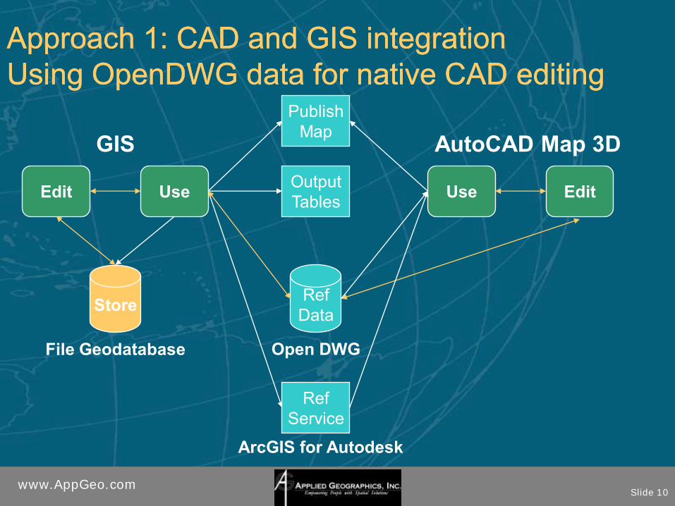
www.AppGeo.comSlide 10
Edit
Store
Use
GIS
Publish
Map
Output
Tables
Ref
Service
Ref
Data
AutoCAD Map 3D
ArcGIS for Autodesk
Approach 1: CAD and GIS integrationApproach 1: CAD and GIS integration
Using OpenDWG data for native CAD editingUsing OpenDWG data for native CAD editing
File Geodatabase Open DWG
Use Edit

www.AppGeo.comSlide 11
Approach 1: CAD and GIS integrationApproach 1: CAD and GIS integration
Using OpenDWG data for native CAD editingUsing OpenDWG data for native CAD editing
ConstraintsConstraints
•• Not symbolized or labeledNot symbolized or labeled
•• Feature layer management issuesFeature layer management issues
•• Only see attributes using ArcGIS for Only see attributes using ArcGIS for AutodeskAutodesk

www.AppGeo.comSlide 12
Approach 2: CAD and GIS integrationApproach 2: CAD and GIS integration
Editing Shapefiles using FDO in CADEditing Shapefiles using FDO in CAD
ProcedureProcedure
•• Export to Shapefiles from geodatabaseExport to Shapefiles from geodatabase Use FDO Connection to symbolize, label, rotate dataUse FDO Connection to symbolize, label, rotate data
Use FDO to edit shape filesUse FDO to edit shape files
•• Import Shapefiles to geodatabaseImport Shapefiles to geodatabase
GoalsGoals
•• Direct editing of GIS Data within CADDirect editing of GIS Data within CAD
•• GIS similarity in Autodesk using Map 3DGIS similarity in Autodesk using Map 3D

www.AppGeo.comSlide 13
Edit
Store
Use
GIS
Publish
Map
Output
Tables
Ref
Service
Ref
Data
AutoCAD Map 3D
ArcGIS for Autodesk
Approach 2: CAD and GIS integrationApproach 2: CAD and GIS integration
Editing Shapefiles using FDO in CADEditing Shapefiles using FDO in CAD
File Geodatabase Shapefiles
Use Edit

www.AppGeo.comSlide 14
Approach 2: CAD and GIS integrationApproach 2: CAD and GIS integration
Editing Shapefiles using FDO in CADEditing Shapefiles using FDO in CAD
ConstraintsConstraints
•• Cannot reference symbolization from other Cannot reference symbolization from other DWG drawingsDWG drawings
•• Shapefiles field length constraintsShapefiles field length constraints
•• FDO objects inflexibleFDO objects inflexible Could not tilt to fit map formatCould not tilt to fit map format
Could not convert to blockCould not convert to block
•• FDO is not familiar to most CAD usersFDO is not familiar to most CAD users

www.AppGeo.comSlide 15
Approach 3: CAD and GIS integrationApproach 3: CAD and GIS integration
Using CAD Blocks and Seed file for integrationUsing CAD Blocks and Seed file for integration
ProceduresProcedures
•• Export to OpenDWG from geodatabaseExport to OpenDWG from geodatabase Python script & seed filePython script & seed file
Clip and rotate using Attach and Query in Map 3DClip and rotate using Attach and Query in Map 3D
•• Data capture/edit information in CADData capture/edit information in CAD Use seed file to create CAD template file (DWT)Use seed file to create CAD template file (DWT)
Add needed/relevant attributes to block (some hidden)Add needed/relevant attributes to block (some hidden)
•• Use GIS to import capture/edit filesUse GIS to import capture/edit files Copy/paste capture/edit CAD filesCopy/paste capture/edit CAD files
QA/QC against original planQA/QC against original plan
Capture extra attribute information from original planCapture extra attribute information from original plan

www.AppGeo.comSlide 16
Approach 3: CAD and GIS integrationApproach 3: CAD and GIS integration
Using CAD Blocks and Seed file for integrationUsing CAD Blocks and Seed file for integration
GoalsGoals
•• Work with Tiled CAD filesWork with Tiled CAD files
•• Make data available for DWG reference Make data available for DWG reference (XREF) (XREF)
•• Simplify data capture with blocksSimplify data capture with blocks
•• Use blocks for symbology/labelingUse blocks for symbology/labeling
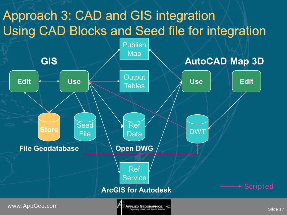
www.AppGeo.comSlide 17
Edit
Store
Use
GIS
Publish
Map
Output
Tables
Ref
Service
Ref
Data
AutoCAD Map 3D
ArcGIS for Autodesk
Approach 3: CAD and GIS integrationApproach 3: CAD and GIS integration
Using CAD Blocks and Seed file for integrationUsing CAD Blocks and Seed file for integration
File Geodatabase Open DWG
Use Edit
Seed
File DWT
Scripted

www.AppGeo.comSlide 18
Approach 3: CAD and GIS integrationApproach 3: CAD and GIS integration
Using CAD Blocks and Seed file for integrationUsing CAD Blocks and Seed file for integration
ConstraintsConstraints
•• Complicated setupComplicated setup
•• Intermediate files for capture/editingIntermediate files for capture/editing
www.AppGeo.comSlide 19
ConclusionsConclusions
•• Need shared open data formatNeed shared open data format
•• ESRI OpenDWG solution is promisingESRI OpenDWG solution is promising Need an Object enabler for AutodeskNeed an Object enabler for Autodesk
•• FDO in Map3D has some major shortcomingsFDO in Map3D has some major shortcomings
•• A well planned workA well planned work--flow goes a long wayflow goes a long way Understand your toolsUnderstand your tools

www.AppGeo.comSlide 20
ResourcesResources
•• ArcGIS For AutoDeskArcGIS For AutoDesk
http://www.esri.com/software/arcgis/arcgishttp://www.esri.com/software/arcgis/arcgis--forfor--autocad/autocad/
•• AutoDesk Map 3DAutoDesk Map 3D
http://usa.autodesk.com/adsk/servlet/index?ihttp://usa.autodesk.com/adsk/servlet/index?id=3081357&siteID=123112d=3081357&siteID=123112

www.AppGeo.comSlide 21
ESRI & AutodeskESRI & Autodesk
Getting from here to thereGetting from here to there
and back againand back again
Guido SteinGuido Stein
[email protected]@guidostein.com
Top Related