


![A flexible anisotropic self-powered piezoelectric direction ...795106/FULLTEXT01.pdfhemisphere; have been reported for vibration and/or direction detection [14, 15, 16]. A. Yu et al](https://static.fdocuments.us/doc/165x107/6109cc907555696b1b53f54b/a-flexible-anisotropic-self-powered-piezoelectric-direction-795106fulltext01pdf.jpg)


Languages
Pages
Legal


UNAGI NET LLC • MOUNTAIN VIEW, CALIFORNIA www.unagi.net • [email protected]
Version 0.91 - Jul 20, 2010 1Advanced information-subject to change
General DescriptionThe CM1015 is a complete electronic compass module, that outputs accurate directional data without the need for manual calibration or additional components. Utilizing a 3 axis magnetometer along with a highly sensitive triaxial accelerometer, the CM1015 calculates it’s position relative to terrestrial magnetism, and outputs it’s direction in degrees. Gyroscopic output data is also available.
With it’s built-in microprocessor core, the CM1015 automatically calibrates itself using patented algorithms, so that the module is always ready to operate correctly. Simply apply DC power to the module, and then read the appropriate registers to find it’s direction. The module does all the detection and heavy calculations.
The CM1015 communicates via a simple serial communication port. The CM1015 only requires a single 3.3VDC power supply and is very low in power consumption (< 350mW).
The CM1015 module is very small in size, 1.0” x 1.5” x 0.13”. This allows the module to be easily incorporated into handheld or other portable devices. The module contains a single 12-pin header which contains all the power and interface signals.
The CM1015 module is built with high-volume manufacturing techniques, to keep quality high and costs low. Each module is 100% tested with accuracy guaranteed.
Features• Completely tested self-contained moduleNo additional circuits or components required
• Patented Auto-CalibrationNo special equipment or methods required to calibrate for accurate direction detection
• Highly accurate direction detectionDirection values from 0.0 to 359.9 degreesIncludes Gyro data: Inclination, Pitch, Roll, Yaw
•Low-power consumptionIdeal for battery operation
• Easy to interfaceSingle DC supply and a simple serial interface.
• Compact size 1.0” x 1.5” x 0.13”Ideal for hand-held or other portable products
Applications• Automobile navigators• Portable GPS mapping equipment• Weather station loggers• Construction equipment• Marine mapping displays
CM1015 ELECTRONIC COMPASS MODULECOMPLETE DIRECTION DETECTION MODULE WITH MAGNETOMETER AND ACCELEROMETER
UNAGI NETLLC

UNAGI NET LLC • MOUNTAIN VIEW, CALIFORNIA www.unagi.net • [email protected]
Version 0.91 - Jul 20, 2010 2Advanced information-subject to change
CM1015 COMPASS MODULE UNAGI NETLLC
MODULE OUTLINE
Reading Direction
1.50”
1.00”
2mm0.032” DIA
1
UNAGI NET LLC • MOUNTAIN VIEW, CALIFORNIA www.unagi.net • [email protected]
Version 0.91 - Jul 20, 2010 3Advanced information-subject to change
CM1015 COMPASS MODULE UNAGI NETLLC
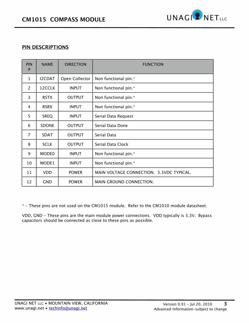
PIN #
NAME DIRECTION FUNCTION
1 I2CDAT Open Collector Non functional pin.*
2 12CCLK INPUT Non functional pin.*
3 RSTX OUTPUT Non functional pin.*
4 RSRX INPUT Non functional pin.*
5 SREQ INPUT Serial Data Request
6 SDONE OUTPUT Serial Data Done
7 SDAT OUTPUT Serial Data
8 SCLK OUTPUT Serial Data Clock
9 MODE0 INPUT Non functional pin.*
10 MODE1 INPUT Non functional pin.*
11 VDD POWER MAIN VOLTAGE CONNECTION. 3.3VDC TYPICAL.
12 GND POWER MAIN GROUND CONNECTION.
PIN DESCRIPTIONS
* - These pins are not used on the CM1015 module. Refer to the CM1010 module datasheet.
VDD, GND - These pins are the main module power connections. VDD typically is 3.3V. Bypass capacitors should be connected as close to these pins as possible.

UNAGI NET LLC • MOUNTAIN VIEW, CALIFORNIA www.unagi.net • [email protected]
Version 0.91 - Jul 20, 2010 4Advanced information-subject to change
CM1015 COMPASS MODULE UNAGI NETLLC
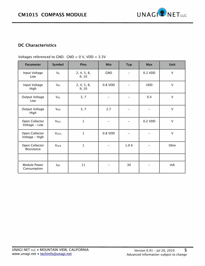
Parameter Symbol Pin Min Typ Max Unit
Supply Voltage (1) VDD 11 2.7 3.3 4.0 V
Input Voltage VIN 2, 4, 5, 8, 9, 10
0.0 - VDD V
Output Current IO 3, 7 - - 3.0 mA
Temperature TA -30 +85 °C
Absolute Maximum Ratings
Supply Voltage -0.3V to 6VInput Voltage -0.3V to 6VVoltage at all other pins -0.3V to 5.5VTMAX 100 C
Voltages referenced to GND; GND = 0 V
Recommended Operating Conditions
(Note 1) Maximum supply voltage ramp-up time is 200uS.
UNAGI NET LLC • MOUNTAIN VIEW, CALIFORNIA www.unagi.net • [email protected]
Version 0.91 - Jul 20, 2010 5Advanced information-subject to change
CM1015 COMPASS MODULE UNAGI NETLLC
DC Characteristics
Parameter Symbol Pins Min Typ Max Unit
Input Voltage Low
VIL 2, 4, 5, 8, 9, 10
GND - 0.2 VDD V
Input Voltage High
VIH 2, 4, 5, 8, 9, 10
0.8 VDD - VDD V
Output VoltageLow
VOL 3, 7 - - 0.4 V
Output VoltageHigh
VOH 3, 7 2.7 - - V
Open CollectorVoltage - Low
VOCL 1 - - 0.2 VDD V
Open CollectorVoltage - High
VOCH 1 0.8 VDD - - V
Open CollectorResistance
VOCR 1 - 1.0 K - Ohm
Module PowerConsumption
IDD 11 - 30 - mA
Voltages referenced to GND; GND = 0 V, VDD = 3.3V

UNAGI NET LLC • MOUNTAIN VIEW, CALIFORNIA www.unagi.net • [email protected]
Version 0.91 - Jul 20, 2010 6Advanced information-subject to change
CM1015 COMPASS MODULE UNAGI NETLLC
Applications Information
Power On
The CM1015 only requires power to begin operation. The module has a built-in reset and watchdog function, therefore all that is required is proper VDD to begin operation.
The maximum power ramp-up is 200uS. If power is applied at a slower ramp-up than 200uS, proper module initialization is not guaranteed and operations may be erratic.
Serial Communication
The CM1015 communicates over a serial port with various control signals. Please refer to the Serial Communication section for additional information on the exact timing signals required.
Direction North
The module facing direction is from the top edge of the module.
Automatic Calibration
The CM1015 has an automatic self-calibration function that operates once the power is applied, and continuously thereafter on a regular basis. The magnetic axis self-calibration is performed when the module is rotated through positions during normal use. No other action is necessary for the module to calibrate to the terrestrial magnetism of the surrounding environment.

UNAGI NET LLC • MOUNTAIN VIEW, CALIFORNIA www.unagi.net • [email protected]
Version 0.91 - Jul 20, 2010 7Advanced information-subject to change
CM1015 COMPASS MODULE UNAGI NETLLC
Serial Communication
The CM1015 module uses simple 2-wire serial communication to send out the present direction data of the module. The module acts as a Master data device, that outputs data and clock signals. Two control signals are also available that control the flow of the data coming out of the module.
SDAT, Serial Data -This is the main serial data output pin.
SCLK, Serial Data Clock -This is a clock signal that is used to indicate when the Serial Data is valid. The Serial Data is valid on the rising edge of this Serial Data Clock pin.
SDONE, Serial Data Done - Active HIGHWhen the entire packet of direction data has been clocked out of the module, this pin will go high to indicate that the direction data packet has finished being output.
SREQ, Serial Data Request - Active HIGHA high signal on the SREQ pin will tell the module that it should go acquire new direction data. This pin should be HIGH for 10uS minimum.
The serial communication handshake flow is detailed out in the Timing Diagrams. The signal ordering is as follows:
- from idle condition : SDONE = HIGH, SREQ = LOW.- Take SREQ high; requests new data from module.- Wait for SDONE to go low.- SDONE goes low; new data will begin clocking out.- Take SREQ low; idle condition.- Wait for SDONE to go high; indicates all data has been clocked out.- SDONE is high; idle condition.
PIN NAME DIRECTION FUNCTION
5 SREQ INPUT Serial Data Request, active low
6 SDONE OUTPUT Serial Data Done, active high
7 SDAT OUTPUT Serial Data
8 SCLK OUTPUT Serial Data Clock

UNAGI NET LLC • MOUNTAIN VIEW, CALIFORNIA www.unagi.net • [email protected]
Version 0.91 - Jul 20, 2010 8Advanced information-subject to change
CM1015 COMPASS MODULE UNAGI NETLLC
Timing Diagrams
Output data and clock timing:
D7 D6 D5 D4 D3 D2 D1 D0
SCLK
SDAT
Output data byte ordering:
Byte 1 Byte 2 Byte 3 Byte 32SDAT
Output handshaking:
Byte 1 Byte 32SDAT
SDONE (OUTPUT)
SREQ (INPUT)
H = All Data Clocked Out
H = Request New Data
L = New Data Acknowledge
L = IDLE IDLEcondition
1
2
3
4
UNAGI NET LLC • MOUNTAIN VIEW, CALIFORNIA www.unagi.net • [email protected]
Version 0.91 - Jul 20, 2010 9Advanced information-subject to change
CM1015 COMPASS MODULE UNAGI NETLLC
Applications Information
Data Format
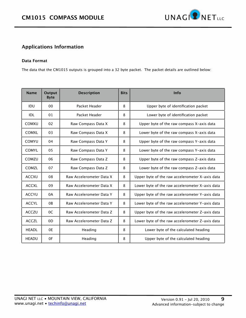
The data that the CM1015 outputs is grouped into a 32 byte packet. The packet details are outlined below:
Name Output Byte
Description Bits Info
IDU 00 Packet Header 8 Upper byte of identification packet
IDL 01 Packet Header 8 Lower byte of identification packet
COMXU 02 Raw Compass Data X 8 Upper byte of the raw compass X-axis data
COMXL 03 Raw Compass Data X 8 Lower byte of the raw compass X-axis data
COMYU 04 Raw Compass Data Y 8 Upper byte of the raw compass Y-axis data
COMYL 05 Raw Compass Data Y 8 Lower byte of the raw compass Y-axis data
COMZU 06 Raw Compass Data Z 8 Upper byte of the raw compass Z-axis data
COMZL 07 Raw Compass Data Z 8 Lower byte of the raw compass Z-axis data
ACCXU 08 Raw Accelerometer Data X 8 Upper byte of the raw accelerometer X-axis data
ACCXL 09 Raw Accelerometer Data X 8 Lower byte of the raw accelerometer X-axis data
ACCYU 0A Raw Accelerometer Data Y 8 Upper byte of the raw accelerometer Y-axis data
ACCYL 0B Raw Accelerometer Data Y 8 Lower byte of the raw accelerometer Y-axis data
ACCZU 0C Raw Accelerometer Data Z 8 Upper byte of the raw accelerometer Z-axis data
ACCZL 0D Raw Accelerometer Data Z 8 Lower byte of the raw accelerometer Z-axis data
HEADL 0E Heading 8 Lower byte of the calculated heading
HEADU 0F Heading 8 Upper byte of the calculated heading

UNAGI NET LLC • MOUNTAIN VIEW, CALIFORNIA www.unagi.net • [email protected]
Version 0.91 - Jul 20, 2010 10Advanced information-subject to change
CM1015 COMPASS MODULE UNAGI NETLLC
Name Output Byte (hex)
Description Bits Info
INCL 10 Inclination 8 Lower byte of the calculated inclination
INCU 11 Inclination 8 Upper byte of the calculated inclination
MAGL 12 Magnitude 8 Lower byte of the calculated magnitude
MAGU 13 Magnitude 8 Upper byte of the calculated magnitude
IDIRL 14 Initial Direction 8 Lower byte of the calculated initial direction
IDIRU 15 Initial Direction 8 Upper byte of the calculated initial direction
PITL 16 Pitch 8 Lower byte of the calculated pitch
PITU 17 Pitch 8 Upper byte of the calculated pitch
ROLL 18 Roll 8 Lower byte of the calculated roll
ROLU 19 Roll 8 Upper byte of the calculated roll
YAWL 1A Yaw 8 Lower byte of the calculated yaw
YAWU 1B Yaw 8 Upper byte of the calculated yaw
--- 1C no data 8 no valid data - all values zero
--- 1D no data 8 no valid data - all values zero
--- 1E no data 8 no valid data - all values zero
--- 1F no data 8 no valid data - all values zero

UNAGI NET LLC • MOUNTAIN VIEW, CALIFORNIA www.unagi.net • [email protected]
Version 0.91 - Jul 20, 2010 11Advanced information-subject to change
CM1015 COMPASS MODULE UNAGI NETLLC
• Byte 00 - IDU (Packet Header, Upper byte)
IDUIDUIDUIDUIDUIDUIDUIDU
7 6 5 4 3 2 1 0
1 0 1 0 0 0 0 0
BITS 7-0 ID (7:0) : Packet Start ID = A0h
• Byte 01 - IDL (Packet Header, Lower byte)
IDLIDLIDLIDLIDLIDLIDLIDL
7 6 5 4 3 2 1 0
0 0 0 0 0 0 0 1
BITS 7-0 ID (7:0) : Packet Start ID = 01h
• Byte 02 - COMXU (Raw Compass Data, X-axis, Upper byte)• Byte 03 - COMXL (Raw Compass Data, X-axis, Lower byte)
COMXUCOMXUCOMXUCOMXUCOMXUCOMXUCOMXUCOMXU
7 6 5 4 3 2 1 0
n n n n n n n n
BITS 7-0 COMXU (7:0) : Upper byte of the raw compass data, in the X-axis
COMXLCOMXLCOMXLCOMXLCOMXLCOMXLCOMXLCOMXL
7 6 5 4 3 2 1 0
n n n n n n n n
BITS 7-0 COMXL (7:0) : Lower byte of the raw compass data, in the X-axis

UNAGI NET LLC • MOUNTAIN VIEW, CALIFORNIA www.unagi.net • [email protected]
Version 0.91 - Jul 20, 2010 12Advanced information-subject to change
CM1015 COMPASS MODULE UNAGI NETLLC
• Byte 04 - COMYU (Raw Compass Data, Y-axis, Upper byte)• Byte 05 - COMYL (Raw Compass Data, Y-axis, Lower byte)
COMYUCOMYUCOMYUCOMYUCOMYUCOMYUCOMYUCOMYU
7 6 5 4 3 2 1 0
n n n n n n n n
BITS 7-0 COMYU (7:0) : Upper byte of the raw compass data, in the Y-axis
COMYLCOMYLCOMYLCOMYLCOMYLCOMYLCOMYLCOMYL
7 6 5 4 3 2 1 0
n n n n n n n n
BITS 7-0 COMYL (7:0) : Lower byte of the raw compass data, in the Y-axis
• Byte 06 - COMZU (Raw Compass Data, Z-axis, Upper byte)• Byte 07 - COMZL (Raw Compass Data, Z-axis, Lower byte)
COMZUCOMZUCOMZUCOMZUCOMZUCOMZUCOMZUCOMZU
7 6 5 4 3 2 1 0
n n n n n n n n
BITS 7-0 COMZU (7:0) : Upper byte of the raw compass data, in the Z-axis
COMZLCOMZLCOMZLCOMZLCOMZLCOMZLCOMZLCOMZL
7 6 5 4 3 2 1 0
n n n n n n n n
BITS 7-0 COMZL (7:0) : Lower byte of the raw compass data, in the Z-axis

UNAGI NET LLC • MOUNTAIN VIEW, CALIFORNIA www.unagi.net • [email protected]
Version 0.91 - Jul 20, 2010 13Advanced information-subject to change
CM1015 COMPASS MODULE UNAGI NETLLC
• Byte 08 - ACCXU (Raw Accelerometer Data, X-axis, Upper byte)• Byte 09 - ACCXL (Raw Accelerometer Data, X-axis, Lower byte)
ACCXUACCXUACCXUACCXUACCXUACCXUACCXUACCXU
7 6 5 4 3 2 1 0
n n n n n n n n
BITS 7-0 ACCXU (7:0) : Upper byte of the raw accelerometer data, in the X-axis
ACCXLACCXLACCXLACCXLACCXLACCXLACCXLACCXL
7 6 5 4 3 2 1 0
n n n n n n n n
BITS 7-0 ACCXL (7:0) : Lower byte of the raw accelerometer data, in the X-axis
• Byte 0A - ACCYU (Raw Accelerometer Data, Y-axis, Upper byte)• Byte 0B - ACCYL (Raw Accelerometer Data, Y-axis, Lower byte)
ACCYUACCYUACCYUACCYUACCYUACCYUACCYUACCYU
7 6 5 4 3 2 1 0
n n n n n n n n
BITS 7-0 ACCYU (7:0) : Upper byte of the raw accelerometer data, in the Y-axis
ACCYLACCYLACCYLACCYLACCYLACCYLACCYLACCYL
7 6 5 4 3 2 1 0
n n n n n n n n
BITS 7-0 ACCYL (7:0) : Lower byte of the raw accelerometer data, in the Y-axis

UNAGI NET LLC • MOUNTAIN VIEW, CALIFORNIA www.unagi.net • [email protected]
Version 0.91 - Jul 20, 2010 14Advanced information-subject to change
CM1015 COMPASS MODULE UNAGI NETLLC
• Byte 0C - ACCZU (Raw Accelerometer Data, Z-axis, Upper byte)• Byte 0D - ACCZL (Raw Accelerometer Data, Z-axis, Lower byte)
ACCZUACCZUACCZUACCZUACCZUACCZUACCZUACCZU
7 6 5 4 3 2 1 0
n n n n n n n n
BITS 7-0 ACCZU (7:0) : Upper byte of the raw accelerometer data, in the Z-axis
ACCZLACCZLACCZLACCZLACCZLACCZLACCZLACCZL
7 6 5 4 3 2 1 0
n n n n n n n n
BITS 7-0 ACCZL (7:0) : Lower byte of the raw accelerometer data, in the Z-axis
• Byte 0E - HEADU (Calculated Heading, Upper byte)• Byte 0F - HEADL (Calculated Heading, Lower byte)
HEADUHEADUHEADUHEADUHEADUHEADUHEADUHEADU
7 6 5 4 3 2 1 0
n n n n n n n n
BITS 7-0 HEADL (7:0) : Upper byte of the calculated heading
HEADLHEADLHEADLHEADLHEADLHEADLHEADLHEADL
7 6 5 4 3 2 1 0
n n n n n n n n
BITS 7-0 HEADU (7:0) : Lower byte of the calculated heading
HEADU & HEADL combine to show the pointed direction in degrees x 10. For example, a value of hex 055F, which is decimal 1375, indicates a heading of 1375/10, which is 137.5 degrees.

UNAGI NET LLC • MOUNTAIN VIEW, CALIFORNIA www.unagi.net • [email protected]
Version 0.91 - Jul 20, 2010 15Advanced information-subject to change
CM1015 COMPASS MODULE UNAGI NETLLC
• Byte 10 - INCL (Calculated Inclination, Lower byte)• Byte 11 - INCU (Calculated Inclination, Upper byte)
INCLINCLINCLINCLINCLINCLINCLINCL
7 6 5 4 3 2 1 0
n n n n n n n n
BITS 7-0 INCL (7:0) : Lower byte of the calculated inclination
INCUINCUINCUINCUINCUINCUINCUINCU
7 6 5 4 3 2 1 0
n n n n n n n n
BITS 7-0 INCU (7:0) : Upper byte of the calculated inclination
Inclination is the path of the terrestrial magnetic field, which varies depending on your location.
• Byte 12 - MAGL (Calculated Magnitude, Lower byte)• Byte 13 - MAGU (Calculated Magnitude, Upper byte)
MAGLMAGLMAGLMAGLMAGLMAGLMAGLMAGL
7 6 5 4 3 2 1 0
n n n n n n n n
BITS 7-0 MAGL (7:0) : Lower byte of the calculated magnitude
MAGUMAGUMAGUMAGUMAGUMAGUMAGUMAGU
7 6 5 4 3 2 1 0
n n n n n n n n
BITS 7-0 MAGU (7:0) : Upper byte of the calculated magnitude
Magnitude is the amount of magnetic flux being detected by the module. This will vary depending on the module’s position and the operating environment.

UNAGI NET LLC • MOUNTAIN VIEW, CALIFORNIA www.unagi.net • [email protected]
Version 0.91 - Jul 20, 2010 16Advanced information-subject to change
CM1015 COMPASS MODULE UNAGI NETLLC
• Byte 14 - IDIRL (Calculated Initial Direction, Lower byte)• Byte 15 - IDIRU (Calculated Initial Direction, Upper byte)
IDIRLIDIRLIDIRLIDIRLIDIRLIDIRLIDIRLIDIRL
7 6 5 4 3 2 1 0
n n n n n n n n
BITS 7-0 IDIRL (7:0) : Lower byte of the calculated initial direction
IDIRUIDIRUIDIRUIDIRUIDIRUIDIRUIDIRUIDIRU
7 6 5 4 3 2 1 0
n n n n n n n n
BITS 7-0 IDIRU (7:0) : Upper byte of the calculated initial direction
Initial direction shows the position the module was pointing when power was applied.
• Byte 16 - PITL (Calculated Pitch, Lower byte)• Byte 17 - PITU (Calculated Pitch, Upper byte)
PITLPITLPITLPITLPITLPITLPITLPITL
7 6 5 4 3 2 1 0
n n n n n n n n
BITS 7-0 PITL (7:0) : Lower byte of the calculated pitch
PITUPITUPITUPITUPITUPITUPITUPITU
7 6 5 4 3 2 1 0
n n n n n n n n
BITS 7-0 PITU (7:0) : Upper byte of the calculated pitch

UNAGI NET LLC • MOUNTAIN VIEW, CALIFORNIA www.unagi.net • [email protected]
Version 0.91 - Jul 20, 2010 17Advanced information-subject to change
CM1015 COMPASS MODULE UNAGI NETLLC
• Byte 18 - ROLL (Calculated Roll, Lower byte)• Byte 19 - ROLU (Calculated Roll, Upper byte)
ROLLROLLROLLROLLROLLROLLROLLROLL
7 6 5 4 3 2 1 0
n n n n n n n n
BITS 7-0 ROLL (7:0) : Lower byte of the calculated roll
ROLUROLUROLUROLUROLUROLUROLUROLU
7 6 5 4 3 2 1 0
n n n n n n n n
BITS 7-0 ROLU (7:0) : Upper byte of the calculated roll
• Byte 1A - YAWL (Calculated Yaw, Lower byte)• Byte 1B - YAWU (Calculated Yaw, Upper byte)
YAWLYAWLYAWLYAWLYAWLYAWLYAWLYAWL
7 6 5 4 3 2 1 0
n n n n n n n n
BITS 7-0 YAWL (7:0) : Lower byte of the calculated yaw
YAWUYAWUYAWUYAWUYAWUYAWUYAWUYAWU
7 6 5 4 3 2 1 0
n n n n n n n n
BITS 7-0 YAWU (7:0) : Upper byte of the calculated yaw
UNAGI NET LLC • MOUNTAIN VIEW, CALIFORNIA www.unagi.net • [email protected]
Version 0.91 - Jul 20, 2010 18Advanced information-subject to change
CM1015 COMPASS MODULE UNAGI NETLLC
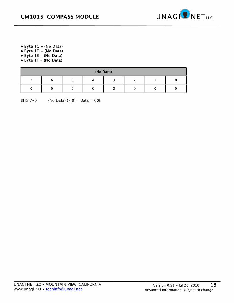
• Byte 1C - (No Data)• Byte 1D - (No Data)• Byte 1E - (No Data)• Byte 1F - (No Data)
(No Data)(No Data)(No Data)(No Data)(No Data)(No Data)(No Data)(No Data)
7 6 5 4 3 2 1 0
0 0 0 0 0 0 0 0
BITS 7-0 (No Data) (7:0) : Data = 00h
Top Related