Yellow-Cedar Decline in the North Coast Forest District … · 5 Yellow-Cedar Decline in the North...
20
Yellow-Cedar Decline in the North Coast Forest District of British Columbia Paul E. Hennon, David V. D’Amore, Stefan Zeglen, and Mike Grainger 1 United States Department of Agriculture Forest Service Pacific Northwest Research Station Research Note PNW-RN-549 October 2005 1 Paul E. Hennon is a research pathologist and David V. D’Amore is a research soil scientist, U.S. Department of Agriculture, Forest Service, Pacific Northwest Research Station, 2770 Sher- wood Lane, Suite 2A, Juneau, AK 99801; Stefan Zeglen is a forest pathologist, British Columbia Forest Service, Coast Forest Region, 2100 Labieux Road, Nanaimo, BC V9T 6E9; and Mike Grainger is a stewardship officer, British Columbia Forest Service, North Coast Forest Service, 125 Market Place, Prince Rupert, BC V8J 1B9. 2 Recently, yellow-cedar was moved from the genus Chamaecyparis Spach (e.g., C. nootkatensis (D. Don) Spach) to Callitropsis Örsted based on its affinity with a newly discovered tree species in northern Vietnam (Little et al. 2004). Abstract The distribution of a forest decline of yellow-cedar ( Callitropsis nootkatensis (D. Don) Örsted) has been documented in southeast Alaska, but its occurrence in British Columbia was previously unknown. We conducted an aerial survey in the Prince Rupert area in September 2004 to determine if yellow-cedar forests in the North Coast Forest District of British Columbia were experiencing a similar fate as in nearby Alaska. Numerous large areas of concentrated yellow-cedar mortality were found, extending the known distribution of the decline problem 150 km south of the Alaska–British Columbia border. The forests with the most concentrated tree death occurred at 300 to 400 m elevation, frequently on south aspects. The appearance of these forests including proximity to bogs; mixtures of dying, recently killed, and long-dead trees; and crown and bole symptoms of dying trees were all consistent with the phenomenon in southeast Alaska. Introduction Yellow-cedar ( Callitropsis nootkatensis (D. Don) Örsted) 2 decline (fig. 1) extends over 200 000 ha in a broad band through southeast Alaska to the Alaska–British Columbia border along Portland Canal (fig. 2) (Wittwer 2004). The problem is specific to yellow-cedar and is characterized on the landscape as a progressive and intensifying process that results in fading trees with thin or offcolor crowns and numerous standing dead trees, some killed recently and others up to 100
-
Upload
truongkien -
Category
Documents
-
view
214 -
download
0
Transcript of Yellow-Cedar Decline in the North Coast Forest District … · 5 Yellow-Cedar Decline in the North...

Yellow-Cedar Decline in the North Coast Forest District of British ColumbiaPaul E. Hennon, David V. D’Amore, Stefan Zeglen, and Mike Grainger1
United States Department of Agriculture
Forest Service
Pacific Northwest Research Station
Research NotePNW-RN-549October 2005
1 Paul E. Hennon is a research pathologist and David V. D’Amore is a research soil scientist, U.S. Department of Agriculture, Forest Service, Pacific Northwest Research Station, 2770 Sher-wood Lane, Suite 2A, Juneau, AK 99801; Stefan Zeglen is a forest pathologist, British Columbia Forest Service, Coast Forest Region, 2100 Labieux Road, Nanaimo, BC V9T 6E9; and Mike Grainger is a stewardship officer, British Columbia Forest Service, North Coast Forest Service, 125 Market Place, Prince Rupert, BC V8J 1B9.2 Recently, yellow-cedar was moved from the genus Chamaecyparis Spach (e.g., C. nootkatensis (D. Don) Spach) to Callitropsis Örsted based on its affinity with a newly discovered tree species in northern Vietnam (Little et al. 2004).
AbstractThe distribution of a forest decline of yellow-cedar (Callitropsis nootkatensis (D. Don) Örsted) has been documented in southeast Alaska, but its occurrence in British Columbia was previously unknown. We conducted an aerial survey in the Prince Rupert area in September 2004 to determine if yellow-cedar forests in the North Coast Forest District of British Columbia were experiencing a similar fate as in nearby Alaska. Numerous large areas of concentrated yellow-cedar mortality were found, extending the known distribution of the decline problem 150 km south of the Alaska–British Columbia border. The forests with the most concentrated tree death occurred at 300 to 400 m elevation, frequently on south aspects. The appearance of these forests including proximity to bogs; mixtures of dying, recently killed, and long-dead trees; and crown and bole symptoms of dying trees were all consistent with the phenomenon in southeast Alaska.
IntroductionYellow-cedar (Callitropsis nootkatensis (D. Don) Örsted)2 decline (fig. 1) extends over 200 000 ha in a broad band through southeast Alaska to the Alaska–British Columbia border along Portland Canal (fig. 2) (Wittwer 2004). The problem is specific to yellow-cedar and is characterized on the landscape as a progressive and intensifying process that results in fading trees with thin or offcolor crowns and numerous standing dead trees, some killed recently and others up to 100

�
ReseARCh Note pNw-RN-549
Figure 1—A large patch of yellow-cedar in decline near sea level close to the northern limits of the decline on Chichagof Island, Alaska.
years ago (Hennon and Shaw 1997). Following death, slow deterioration owing to yellow-cedar’s unique heartwood chemistry (Barton 1976) allows snags to remain standing for up to a century. As these standing dead trees accumulate, 70 percent or more of yellow-cedar basal area is typically found dead in these forests. Thus, where mortality is this intensive, the problem is not difficult to detect by recon-naissance flights or other types of remote sensing.
The primary cause of the decline is unknown, although no biotic factor ap-pears to be the cause (Hennon et al. 1990b). Site characteristics including wet soils, open-canopy conditions, and elevation appear to be related to yellow-cedar decline (Hennon et al. 1990a). Current research emphasis in Alaska is on the con-tributing roles of hydrology, soil chemistry, air and soil temperature, snowpack, freezing injury, and climate. The susceptibility of yellow-cedar to spring freezing injury in areas of little snowpack forms a leading hypothesis for this forest decline (Hennon and Shaw 1994). Yellow-cedar is thought to be susceptible to frost injury, particularly in areas where soil is not protected from freezing by snow (Klinka et al. 2000). Previously, we investigated the northwestern edges of the yellow-cedar natural range in Prince William Sound, Alaska, where we found the tree to be thriving and without evidence of decline (Hennon and Trummer 2001). Informa-tion on the entire distribution of yellow-cedar decline, including the southern limits, is needed as we attempt to determine how significantly climate is involved.

�
Yellow-Cedar Decline in the North Coast Forest District of British Columbia
Figure 2—Distribution of yellow-cedar decline in southeast Alaska and inset map of the natural range of yellow-cedar.

4
ReseARCh Note pNw-RN-549
Nothing suggests that yellow-cedar decline would stop at the U.S.-Canada international border near Dixon Entrance and Portland Canal. Yellow-cedar decline has been acknowledged as probably occurring in British Columbia (Banner et al. 1993), but it has not been investigated to any extent.
In British Columbia, yellow-cedar commonly occurs in the windward portion of higher elevation Mountain Hemlock (MHmm1 and MHwh1) subzones (table 1). It is also widely distributed throughout the Coastal Western Hemlock zone at low elevations in the very wet hypermaritime (CWHvh2) and very wet maritime (CWHvm1) subzones and at higher levels in the CWHvm2 subzone (Banner et al. 1993, Klinka et al. 2000, Pojar et al. 1987). These areas encompass much of the outer coast of British Columbia including the Queen Charlotte Islands, the western side of the Coast mountains, and the Hecate Depression.
table 1—ecological distribution of yellow-cedar in north coastal British Columbia Subzone or varianta
CWHvh2 CWHvm1 CWHvm2 MHmm1 MHwh1
Elevation range 0–600 m 0–400 (500) m 400–800 m 800–1200 m 600–1100 m
Physiographic region Hecate Lowland Western slope of Western slope of Western slope of Hecate Lowland Coast mountains Coast mountains Coast mountains
Climate Hypermaritime; Wet, humid, mild Cooler with shorter Maritime, cool and Hypermaritime; mild, cool, very mild maritime climate growing season very wet year foggy, wet with with very little with relatively and much heavier round with deep, wet intermittent snow; foggy and little snow and snow pack than wet snow (up snowpack (<0.5 m) rainy year round long growing CWHvm1 to 3 m); soils season never freeze
Associated tree species Western redcedar, Western hemlock, Western hemlock, Mountain hemlock, Mountain hemlock, (in decreasing order western hemlock, amabilis fir, amabilis fir, amabilis fir, western redcedar, of occurrence) lodgepole pine, western redcedar, mountain hemlock western hemlock western hemlock, mountain hemlock Sitka spruce Sitka spruce lodgepole pinea CWHvh2 = Coastal Western Hemlock Zone very wet hypermaritime central variant, CWHvm1 = Coastal Western Hemlock Zone very wet maritime submontane variant, CWHvm2 = Coastal Western Hemlock Zone very wet maritime montane variant, MHmm1 = Mountain Hemlock Zone moist maritime windward variant, and MHwh1 = Mountain Hemlock Zone wet hypermaritime windward variant. Source: Banner et al. 1993.
Yellow-cedar can be found in mixed-species forests at low elevation along with western redcedar (Thuja plicata Donn ex D. Don), western hemlock (Tsuga heterophylla (Raf.) Sarg.), and other species (such as lodgepole pine or shore pine [Pinus contorta Dougl. ex Loud.], mountain hemlock [Tsuga mertensiana (Bong.) Carr.], Pacific silver fir [Abies amabilis Dougl. ex Forbes], Sitka spruce [Picea sitchensis (Bong.) Carr.]) (table 1), but it reaches its greatest concentra-tions at middle and higher elevations in the North Coast Forest District (Banner

5
Yellow-Cedar Decline in the North Coast Forest District of British Columbia
et al. 1993, Klinka et al. 2000). Yellow-cedar has the same affinity for middle and higher elevations in southern portions of southeast Alaska, but north of latitude 55°, the northern extent of western redcedar, yellow-cedar is also abundant at low eleva-tions down to sea level. Here, the decline problem is restricted to low elevations, in places occurring only from sea level to 150 m elevation.
Kayahara and Klinka (1997) recommended that a survey was needed to con-firm that yellow-cedar decline was not a factor in the low-productivity forests of British Columbia. Thus, in late summer 2004, we organized a cooperative project to combine experience mapping yellow-cedar decline in southeast Alaska with lo-cal knowledge of forest conditions and landscape characteristics to document any occurrence of yellow-cedar decline in British Columbia. This report documents evidence of yellow-cedar decline through photographs and gives observations of several areas of the North Coast Forest District of British Columbia.
observations We investigated two low-elevation forests with road access near Prince Rupert (fig. 3) on 26 September 2004: Rainbow Summit and Diana Lake (fig. 4). We found dead yellow-cedar trees at both sites, but yellow-cedar was not the predominant species in these forests. Western redcedar was much more abundant and was often found with a spike top (dead top), a characteristic of the tree throughout its natural range (Hosie 1979). Thus, the relatively sparse occurrence of yellow-cedar made judging the status of yellow-cedar decline difficult. Also, the abundance of spike-top western redcedar trees added confusion because they produce an appear-ance similar to scattered yellow-cedar mortality when viewed from a distance (fig. 5).
On 27 September 2004, we conducted observations on a Bell 206 Long Ranger helicopter approximately 50 km north and 100 km south of Prince Rupert. The helicopter allowed us access to predetermined locations known to have an abun-dance of yellow-cedar and slow so as to carefully observe the forest. During our flights, we located and mapped a number of stands of dead and dying yellow-cedar (figs. 6 through 14) that exhibited an appearance typical of the decline problem in Alaska (fig. 1).
Dense patches of dying and standing dead trees were observed often in proxim-ity to bogs. The snags consistently represented mixtures of trees that died at differ-ent times; some recent mortality had fine or secondary branches retained, whereas other older mortality had intact tops but no attached limbs. From the air, dead yellow-cedar trees can often be distinguished from all species other than western redcedar because their tops do not break as they deteriorate. Upon ground observa-

�
ReseARCh Note pNw-RN-549
Figure 3—North Coast Forest District of British Columbia depicting the sites where we found yellow-cedar decline. Also shown are the two low-elevation sites that we accessed by road (Rainbow Summit and Diana Lake), where the status of yellow-cedar decline is less certain.

�
Yellow-Cedar Decline in the North Coast Forest District of British Columbia
tion, we confirmed that the majority of the completely dead snags were yellow-cedar by visually inspecting and smelling exposed wood after chopping with a hatchet, or, for snags with bark retained, by the presence of resin ducts in the bark. Dying yellow-cedar trees with thin or off-color crowns were present in each of the declin-ing stands that we mapped from the air. On the ground, we observed necrotic lesions emerging from dead roots and extending up the bole of dying trees, a symptom of yellow-cedar decline in Alaska (Hennon 1990b). The remaining live forest com-prised western hemlock, western redcedar, Sitka spruce, shore pine, and some yellow-cedar, the latter usually present as understory trees.
Most of the forests with concentrations of dead trees that we mapped were located at approximately 300 to 400 m elevation, areas that favor forests with high components of yellow-cedar. As yellow-cedar is the principal species that dies in this syndrome, only scattered mortality would be expected at lower elevations where yellow-cedar is often present as a minor component. Perhaps yellow-cedar decline is severe, and thus easily detectable, only at elevations high enough to have a large component of yellow-cedar. We speculate that yellow-cedar growing at even higher elevations may be protected from freezing by snow in early spring, either directly by snow covering shallow fine roots or indirectly by snow delaying the dehardening process (i.e., loss of cold tolerance).
Our brief survey confirms that yellow-cedar decline is present in British Columbia, extending in concentrated patches of dead trees at least 100 km south of Prince Rupert, or 150 km from the Alaska–British Columbia border. Clearly, this is just an initial step that should be followed by a more extensive survey. Ground plots or forest inventory data could be used to evaluate the condition of yellow-cedar, particularly in low-elevation areas where yellow-cedar is not a dominant component. This could help resolve the status of yellow-cedar and western redcedar in the low-elevation forests that have an abundance of dead trees or spike-topped trees. We recommend extending the aerial survey farther south to determine the southern extent of the distribution of yellow-cedar decline. This will aid in our interpretation of the causes of the problem, including the role of climate. Information on the process that damages yellow-cedar trees in British Columbia and Alaska is needed to develop a management strategy for this valuable species tailored to areas where it is dying now, where it is expected to die in the future in a warming climate, and where the decline problem is not expected to occur.

�
ReseARCh Note pNw-RN-549
observations at each LocationThe following are photographs of locations where we made observations in our search for yellow-cedar decline in the North Coast Forest District of British Columbia.
Several other locations of dead trees were detected but photographs are not included in this report. Mortality was observed in a wet forested bog complex near Tuck Inlet. Scattered dead trees were noted at low elevation on the east side of Kennedy Island. At Captain Cove, relatively low concentrations of dead trees were observed on a hillside with south aspect at about 300 m. Two large bowls nearby at about 400 m elevation contained new and old yellow-cedar snags. One small patch with a concentration of dead cedars was observed on an exposed ridge. Concentrated mortality was detected on the north side of Holmes Lake on Pitt Island at about 350 m elevation, some of which was on steep terrain. A very large area of scattered snags could be seen extending at lower elevations along Petrel Channel on Pitt Island from Holmes Lake to Hevenor Inlet.
Figure 4—Diana Lake. Small patch of dead trees of both cedar species at a low-elevation bog wood-land–bog forest complex. Generally, yellow-cedar occurs only as a minor component in low-elevation forests in areas such as Diana Lake. Large concentrations of dead trees were not found at this site.

9
Yellow-Cedar Decline in the North Coast Forest District of British Columbia
Figure 5—Scattered dead and dead-topped trees in a mixed western redcedar–yellow-cedar–western hemlock forested landscape at low elevation near Prince Rupert. Location is not shown on the map in figure 3. The abundance of spike-top, partially dead western redcedar confounds the identification of yellow-cedar decline in these mixed-cedar forests. The wood of both yellow-cedar and western redcedar is resistant to decay, and the slow deterioration of both tree species often leaves tree tops intact long after death. Thus, ground surveys would probably be needed to determine the live and dead populations of each species before judging whether forests such as this have a yellow-cedar decline problem.
Figure 6—Crow Lagoon. This dense patch of snags illustrates the typical appearance of yellow-cedar decline: a mixture of older mortality, recently killed trees, and some dying trees. An estimated 70 to 80 percent of the overstory yellow-cedar trees was dead in this stand. This declining yellow-cedar forest was located above an open sloping bog on an east-southeast aspect at about 300 m elevation.
10
ReseARCh Note pNw-RN-549
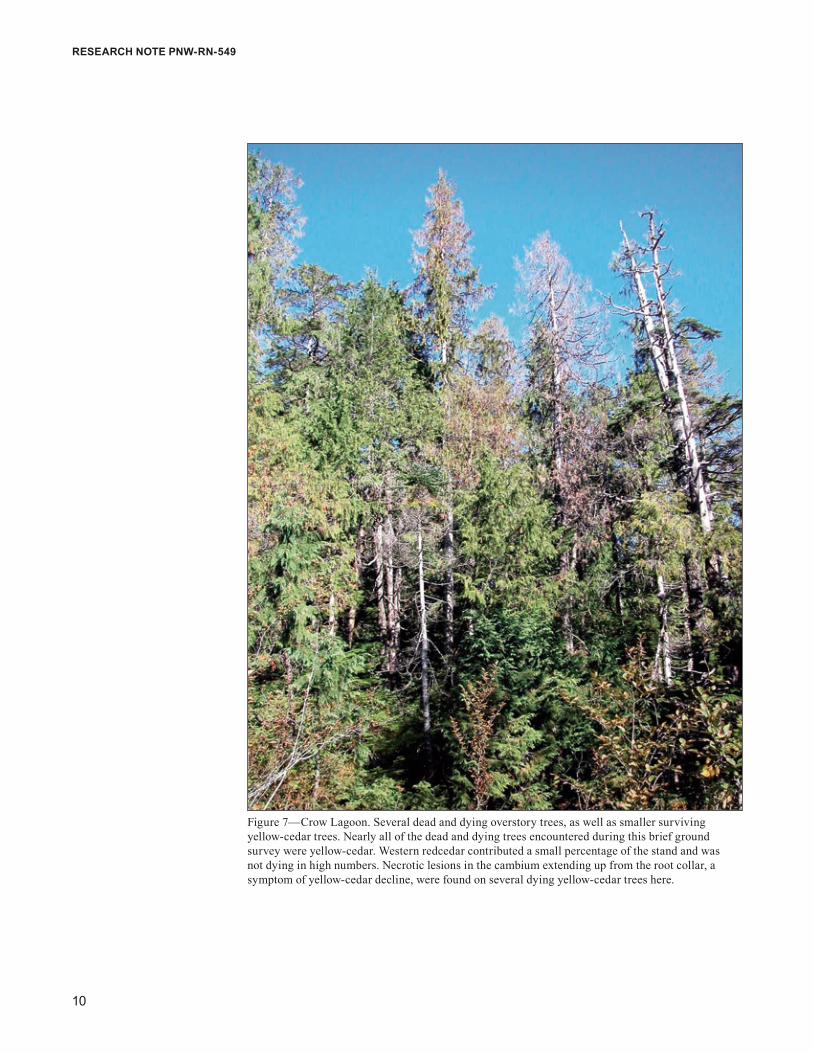
Figure 7—Crow Lagoon. Several dead and dying overstory trees, as well as smaller surviving yellow-cedar trees. Nearly all of the dead and dying trees encountered during this brief ground survey were yellow-cedar. Western redcedar contributed a small percentage of the stand and was not dying in high numbers. Necrotic lesions in the cambium extending up from the root collar, a symptom of yellow-cedar decline, were found on several dying yellow-cedar trees here.

11
Yellow-Cedar Decline in the North Coast Forest District of British Columbia
Figure 8—Union Inlet. Extensive, more diffuse yellow-cedar decline on a concave hillslope at approximately 300 m elevation that covered hundreds of hectares (much of the area beyond the photograph).
Figure 9—Union Inlet. A high concentration of dead yellow-cedar trees on gentle terrain surround-ing bogs.
1�
ReseARCh Note pNw-RN-549
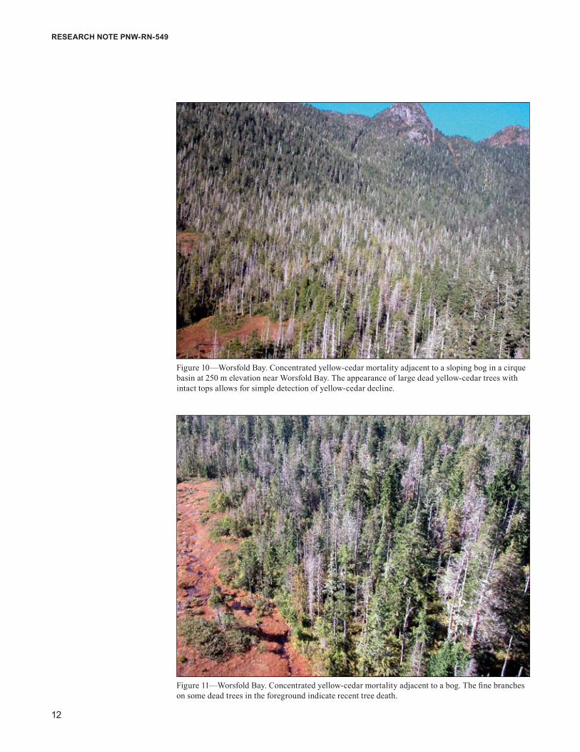
Figure 10—Worsfold Bay. Concentrated yellow-cedar mortality adjacent to a sloping bog in a cirque basin at 250 m elevation near Worsfold Bay. The appearance of large dead yellow-cedar trees with intact tops allows for simple detection of yellow-cedar decline.
Figure 11—Worsfold Bay. Concentrated yellow-cedar mortality adjacent to a bog. The fine branches on some dead trees in the foreground indicate recent tree death.

1�
Yellow-Cedar Decline in the North Coast Forest District of British Columbia
Figure 12—A concentrated patch of large yellow-cedar snags at about 300 m on a hillside above a cutting unit near Hayward Creek. Another patch of dead yellow-cedar (not shown) was found nearby at about 400 m elevation.
Figure 13—A closer view of the patch of yellow-cedar decline near Hayward Creek. Note the dying orange-crowned yellow-cedar trees interspersed with the dead yellow-cedar snags. This illustrates the progressive intensification of this forest decline.

14
ReseARCh Note pNw-RN-549
Figure 14—Cypress Lake, Banks Island. Dead trees associated with the edges of a bog depression. We observed large areas of mortality in a mosaic of scattered dead trees and higher concentrations from Donaldson Lake to north of Cypress Lake at various elevations and aspects. The more concen-trated mortality had large dead trees and occurred on steeper slopes with greater forest productivity. We landed on a boggy hillside north of Cypress Lake at about 300 m elevation. Here, we found new and old snags, nearly all yellow-cedar. Most of the western redcedar was live, although some had spike tops. All trees were relatively small at this wet site.
AcknowledgmentsWe thank the British Columbia Forest Service for providing funds for use of a heli-copter. Reviewers Alex Woods, Lori Trummer, and Dustin Wittwer made valuable suggestions on a draft of this report.
english equivalentsWhen you know: Multiply by: To get:
Meters (m) 3.28 FeetKilometers (km) .6214 MilesHectares (ha) 2.47 Acres

15
Yellow-Cedar Decline in the North Coast Forest District of British Columbia
Literature CitedBanner, A.; MacKenzie, W.; Haeussler, S.; Thomson, S.; Pojar, J.;
Trowbridge, R. 1993. A field guide to site identification and interpretation for the Prince Rupert Forest Region; Parts 1 and 2. Land Mgmt. Handb. 26. Victoria, BC: Research Branch, British Columbia Ministry of Forests.
Barton, G.M. 1976. A review of yellow-cedar (Chamaecyparis nootkatensis (D. Don) Spach) extractives and their importance to utilization. Wood and Fiber. 8(3): 172–176.
Hennon, P.E.; Hansen, E.M.; Shaw, C.G., III. 1990a. Dynamics of decline and mortality of Chamaecyparis nootkatensis in southeast Alaska. Canadian Journal of Botany. 68: 651–662.
Hennon, P.E.; Shaw, C.G., III. 1997. The enigma of yellow-cedar decline: What is killing these long-lived defensive trees? Journal of Forestry. 95(12): 4–10.
Hennon, P.E.; Shaw, C.G., III. 1994. Did climatic warming trigger the onset and development of yellow-cedar decline in southeast Alaska? European Journal of Forest Pathology. 24: 399–418.
Hennon, P.E.; Shaw, C.G., III.; Hansen, E.M. 1990b. Symptoms and fungal associations of declining Chamaecyparis nootkatensis in southeast Alaska. Plant Disease. 74: 267–273.
Hennon, P.E.; Trummer, L.M. 2001. Yellow-cedar (Chamaecyparis nootkatensis) at the northwest limits of its natural range in Prince William Sound, Alaska. Northwest Science. 75: 61–71.
Hosie, R.C. 1979. Native trees of Canada. 8th ed. Markham, ON: Fitzhenry and Whiteside, Ltd. 380 p.
Kayahara, G.J.; Klinka, K. 1997. The potential for managing nutrient poor and low productivity yellow cedar-redcedar-hemlock forests of North Coastal British Columbia, a problem analysis. Vancouver, BC: University of British Columbia; Smithers, BC: British Columbia Ministry of Forests, Prince Rupert Forest Region, 52 p.
Klinka, K.; Worrall, J.; Skoda, L.; Varga, P. 2000. The distribution and synopsis of ecological and silvical characteristics of tree species of British Columbia’s forests. Coquitlam, BC: Canadian Cartographics Ltd. 180 p.

1�
ReseARCh Note pNw-RN-549
Little, D.P.; Schwarzbach, A.E.; Adams, R.P.; Hsieh, C.F. 2004. The circumscription and phylogenetic relationship of Callitropsis and the newly described genus Xanthocyparis (Cupressaceae). American Journal of Botany. 91: 1872–1881.
Pojar, J.; Klinka, K.; Meidinger, D.V. 1987. Biogeoclimatic ecosystem classification in British Columbia. Forest Ecology and Management. 22: 119–154.
Wittwer, D., comp. 2004. Forest health conditions in Alaska—2003: a forest health protection report. Gen. Tech. Rep. R10-TP-123. Anchorage, AK: U.S. Department of Agriculture, Forest Service, Alaska Region. 82 p.


Pacific Northwest Research Station web site http://www.fs.fed.us/pnwtelephone (503) 808-2592publication requests (503) 808-2138FAX (503) 808-2130e-mail [email protected] address Publications Distribution Pacific Northwest Research Station P.O. Box 3890 Portland, OR 97208-3890
The Forest service of the U.S. Department of Agriculture is dedicated to the principle of multiple use management of the Nation’s forest resources for sustained yields of wood, water, forage, wildlife, and recreation. Through forestry research, cooperation with the States and private forest owners, and management of the National Forests and National Grasslands, it strives—as directed by Congress—to provide increasingly greater service to a growing Nation.
The U.S. Department of Agriculture (USDA) prohibits discrimination in all its programs and activities on the basis of race, color, national origin, age, disability, and where applicable, sex, marital status, familial status, parental status, religion, sexual orientation, genetic information, political beliefs, reprisal, or because all or part of an individual’s income is derived from any public assistance program. (Not all prohibited bases apply to all programs.) Persons with disabilities who require alternative means for communication of program information (Braille, large print, audiotape, etc.) should contact USDA’s TARGET Center at (202) 720-2600 (voice and TDD). To file a complaint of discrimination, write USDA, Director, Office of Civil Rights, Room 1400 Independence Avenue, SW, Washington, DC 20250-9410 or call (800) 795-3272 (voice) or (202) 720-6382 (TDD). USDA is an equal opportunity provider and employer.

U.S. Department of Agriculture Pacific Northwest Research Station 333 SW First Avenue P.O. Box 3890 Portland, OR 97208-3890
Official Business Penalty for Private Use, $300