
WY GIS Business Plan V2 Draft Final
34
State of Wyoming Geographic Information Systems (GIS) Business Plan for establishing a Geographic Information Officer (GIO) and supporting GIS Technical Services Program (TSP) Developed by www.appgeo.com Version 1.0 - February 16, 2007 (V 2.0 - April 15, 2007)
Transcript of WY GIS Business Plan V2 Draft Final

State of Wyoming
Geographic Information Systems (GIS) Business Plan
for establishing a
Geographic Information Officer (GIO)
and supporting GIS Technical Services Program (TSP)
Developed by
www.appgeo.com
Version 1.0 - February 16, 2007 (V 2.0 - April 15, 2007)

ii
Document History
and Citation & Copyright Information
The development of this document was funded by the Federal Geographic Data
Committee (FGDC) through a National Spatial Data Infrastructure (NSDI) Cooperative Agreements Program (CAP) Fifty States Initiative Grant in Fiscal Year 2006, Award
Number 06HQAG0095. Version 1.0 was developed by Applied Geographics, Inc. (AppGeo; Boston, MA) in collaboration with Flitner Communications (Jackson, WY)
and the Wyoming CAP Grant Project Team. The following table summarizes the history of subsequent updates and revisions to this document.
Version # Date Description Responsible Party
1.0 February 16, 2007 Final Contractor Deliverable AppGeo
2.0 April 15, 2007 Final FGDC Grant Deliverable WY CAP Grant
Project Team
The following is the recommended citation for this document:
State of Wyoming. 2007. Geographic Information Systems Business Plan for Establishing a Geographic Information Officer and Supporting GIS Technical Services Program, Version 2.0. Cheyenne, WY: State of Wyoming, Office of the
Chief Information Officer.
Copyright Notice
The GIS Business Plan document is the Property of the State of Wyoming and its subdivisions. All permitted copies shall be reproduced with all titles, logos, copyright
notices, trademark notices, and legends included in the original materials.

iii
Preface
The need for better statewide coordination in the development and use of geographic data and technology to support diverse stakeholders across the State of Wyoming was articulated in Executive Order 2006-1 (EO) issued by Governor Dave Freudenthal in April, 2006. A synopsis of the current situation was outlined in the EO, including the following highlights:
• The State of Wyoming is facing many challenges, including increased development of energy resources, homeland security, and environmental protection
• The State finds itself working with various levels of regional and local governments and private industry in an ever -growing scale
• GIS has proven to be an effective tool in policy development, decision making, management, engineering and research in almost all state, local, and federal government agencies and private industry
• GIS use will greatly benefit from a statewide coordinated effort to streamline government use, expand agency cooperation, and take advantage of grant opportunities and cooperatively leveraged funds
• GIS demand has outgrown current efforts to coordinate The EO established a GIS Coordination Structure, including a Governor appointed Oversight Committee, and a Technical Advisory Group, each with specific duties. Key success factors for this coordination effort, which were recommended in the separate State of Wyoming Strategic Plan for Statewide GIS Coordination, are:
• To establish a dedicated Geographic Information Officer (GIO) position within the State’s Office of the Chief Information Officer
• To establish a GIS Technical Services Program (TSP) hosted by an entity such as the Wyoming Geographic Information Science Center (WyGISC) at the University of Wyoming
These recommendations from the GIS Strategic Planning effort are widely endorsed by the GIS community, and this Business Plan is the blueprint for implementation. GIS coordination will benefit the state economy, including streamlining and strengthening government utilization of geographic data and technology. To assist in coordination efforts, a National Spatial Data infrastructure (NSDI) Cooperative Agreement Program (CAP) grant was received from the Federal Geographic Data Committee (FGDC) to help develop a Business Plan and Education Strategy for GIS. The State’s fiduciary agent for this grant is the Office of the CIO, consistent with the responsibility established by the Governor for the OCIO to provide administrative support to the Wyoming GIS Coordination Structure. To direct and perform work under this grant, the OCIO organized a Wyoming CAP Grant Project Team to represent a cross-section of the State’s GIS Coordination Structure. Members include (in alphabetical order):

iv
• Joe Ahern, Deputy CIO, State of Wyoming • Larry Biggio, CIO, State of Wyoming (retired 12/31/06) • Jeff Hamerlinck, University of Wyoming • Bob Nicholls, Office of the CIO, State of Wyoming (through 3/23/07) • Cathy Raney, Campbell County • Barbara Ray, US Geological Survey • Ben Saunders, WY Department of Transportation • Randy Wiggins, US Natural Resources Conservation Service
This team has oversight on the work of the competitively selected Contractor Team, comprised of Applied Geographics, Inc. (AppGeo) of Boston, Massachusetts, and Flitner Communications (Flitner) of Jackson, Wyoming. The methodology, assumptions, and constraints applied by the team can be summarized as follows:
• Work within the framework of the Governor’s EO on GIS Coordination • Understand the optimistic bias toward implementing a Coordination Structure • Recognize the pressing need for cross-agency coordination of cross-agency
activities • Gather input from key officials and stakeholders as part of the planning process
through a combination of face to face interviews and a questionnaire. [The eleven groups interviewed are listed in the appendices.]
• Identify measures to achieve greater coordination and benefits consistent with the input gathered from key officials and stakeholders
• Work within the budget and timeframe determined by the CAP grant for this plan • Exercise judgment consistent with industry and government best practices

v
Table of Contents
1 EXECUTIVE SUMMARY ................................................................................................................. 1 2 PROGRAM GOALS AND OBJECTIVES ....................................................................................... 2 3 PROGRAM REQUIREMENTS AND BENEFITS.......................................................................... 3
3.1 SPECIFIC OBJECTIVES AND REQUIREMENTS ................................................................................. 4 3.2 BENEFIT CASE STUDIES ............................................................................................................... 6
3.2.1 Office of Homeland Security ................................................................................................... 6 3.2.2 Wyoming Department of Transportation, Bridge Program .................................................... 7 3.2.3 Office of State Lands and Investments .................................................................................... 7 3.2.4 Department of Environmental Quality, In-Field Data Collection .......................................... 8 3.2.5 Cross-Agency Communication and Coordination .................................................................. 8
3.3 THE ROLE OF THE GIO IN AN ENTERPRISE APPROACH ................................................................. 9 3.4 BENEFITS ................................................................................................................................... 10 3.5 ALTERNATIVES TO THE GIO INITIATIVE ..................................................................................... 13
4 ORGANIZATIONAL APPROACH ............................................................................................... 14 4.1 GEOGRAPHIC INFORMATION OFFICER (GIO) .............................................................................. 14 4.2 TECHNICAL SERVICES PROGRAM (TSP) ..................................................................................... 15 4.3 OVERSIGHT FOR THE GIO INITIATIVE ........................................................................................ 16 4.4 COMPARISON TO OTHER STATES: THE 50 STATES INITIATIVE ................................................... 16
5 PROGRAM COSTS ......................................................................................................................... 17 5.1 DETAILED PROGRAM COSTS ...................................................................................................... 18 5.2 GENERAL COSTS ........................................................................................................................ 19 5.3 RISK ASSESSMENT ..................................................................................................................... 19
6 IMPLEMENTATION PLAN ........................................................................................................... 21 6.1 THREE YEAR IMPLEMENTATION PLAN ....................................................................................... 21 6.2 PROGRAMMATIC SCORECARD .................................................................................................... 21 6.3 FUNDING PLAN .......................................................................................................................... 26 6.4 EDUCATION AND OUTREACH ..................................................................................................... 26
7 APPENDICES ................................................................................................................................... 29

Version 2.0 State of Wyoming GIS Business Plan 1
11 EEXXEECCUUTTIIVVEE SSUUMMMMAARRYY The Problem The State of Wyoming has been active in GIS for many years. Investments have been made in the data and the technology, but the investments have mostly been made by individual departments, resulting in single-purpose ‘silos’ and ‘stove-pipes’ which are generally not providing the optimal support to benefit Wyoming on cross-agency activities such as energy development permitting. Even though there is a strong GIS Coordination Structure established by the Governor of Wyoming, several deficiencies have been identified as priorities for corrective action. These include the following:
• Duplication of effort • Lack of awareness of full data holdings or data collection activities • Lack of sufficient data quality and dissemination to support cross-agency
activities (such as energy development, disaster response, public health, land development, and ad hoc requests for GIS products)
• Lack of enterprise infrastructure to support timely and friction-less data sharing • Lack of direct accountability for coordinating statewide GIS investments and
infrastructure developments
The Solution The State of Wyoming will benefit economically, socially, and systematically from the implementation of a Geographic Information Officer (GIO) and closely aligned Technical Services Program (TSP) for GIS. The TSP would be under the direction of the GIO. This initiative will strengthen and streamline the State’s GIS activities. This Business Plan for GIS Coordination lays out the benefits and costs for moving forward with the GIO Initiative. Estimates are made based on an analysis of the objectives and requirements of the Initiative, which roll-up under the banner of cross-agency coordination and services. The alternative of maintaining the status quo will not harvest the benefits of the GIO Initiative, and would likely increase the long-term costs to the State, from inefficiencies and diseconomies. Plan of Action The needs for coordination and communication across the GIS community, and for leadership on data quality and sharing, were clearly and frequently expressed in the interviews with key officials and stakeholders. The GIO, in alignment with State objectives for strengthening and streamlining, would be responsible for filling these needs. The GIO position will be established within the Office of the Chief Information Officer (OCIO). The Technical Services Program (TSP), operating under the direction of the GIO, would make tangible and measurable progress toward data quality assurance and data dissemination. The TSP could be hosted at a facility such as the Wyoming Geographic Information Science Center (WyGISC) at the University of Wyoming.

Version 2.0 State of Wyoming GIS Business Plan 2
The infrastructure needed to support an enterprise-wide approach will not emerge organically from the independent actions of individual departments. The greater public good is served by explicitly chartering and funding the GIO Initiative to get this done, with responsibility and accountability. The State of Wyoming will achieve greater prosperity and effectiveness by moving forward with the proposed Initiative. Details are included in this Business Plan.
22 PPRROOGGRRAAMM GGOOAALLSS AANNDD OOBBJJEECCTTIIVVEESS Given resource constraints in state government, the key economic goal of the GIO Initiative is to enhance the investment that Wyoming has made in GIS. The key operational goal is more effective utilization of GIS through Cross-Agency Coordination and Services. These goals emerged clearly from the interviews that were conducted with key officials and stakeholders during the development of this Business Plan. Objectives related to Cross-Agency Coordination are explained in more detail in the body of the plan document. Briefly, they include:
• Data Quality and Sharing • Coordination and Communication • Policy and Standards • Quantifying and Qualifying Benefits • User Needs
To achieve these goals and objectives, the Initiative being proposed for Wyoming, includes the chartering and funding of a Geographic Information Officer (GIO) position, and a Technical Services Program (TSP) for GIS support. These program elements are further explained, below, as primary action items for success:
• Establish a dedicated Geographic Information Officer (GIO) position within the State’s Office of the Chief Information Officer
• In support of the GIO and overall GIS in Wyoming, establish a Technical Services Program (TSP) to function much as the Wyoming Geographic Information Science Center (WyGISC) at the University of Wyoming presently does, only on an expanded scale.
The state is already investing in GIS, but to date, no one tracks the amount of total expenditures on staff and technology to support GIS. The envisioned GIO Initiative is intended to leverage existing efforts to strengthen and streamline programs that could benefit from cross-agency coordination and services. Based on the interviews performed by the contractor project team, the various agencies and stakeholders contacted have different levels of GIS investment, from very small to substantial. The independent efforts of the many agencies using GIS have resulted in a sub-optimal allocation of resources, largely due to duplication of effort, lack of economies of scale, and a reliance on volunteerism for coordination and sharing, with associated diseconomies.

Version 2.0 State of Wyoming GIS Business Plan 3
Meanwhile, the demand for GIS capacity has grown, and a clear emergence of Cross-Agency Activities has occurred. These activities cut across jurisdictions and deal with public issues that affect a broad cross-section of citizens. They are fundamental to the quality of life and future prospects in Wyoming, and include the following examples:
• Energy Development Impact • Land Development • Public Health • Disaster Response • Ad Hoc Requests
All of these Cross-Agency Activities are supported by GIS and could be managed more effectively and delivered more efficiently with better coordinated use of GIS technology. In terms of prioritization, the following matrix was created and used by the Project Team to rank the relative importance of both Cross-Agency Activities and Cross-Agency Coordination. The overall importance of each Cross-Agency Activity as well as the overall importance of each GIS related objective was rated on a scale of 1 to 5 (most to least important). Then, the specific GIS goal within each cross-agency activity was rated in relative qualitative terms (high, medium, or low importance).
It is clear that improvements in data quality and sharing, as well as coordination and communication, will significantly support cross-agency activities. Of these activities, recognizing that all of them are important, Energy Development Impacts are deemed the most important by the Project Team, based on independent rankings. It is believed that this activity may have the greatest potential to benefit from improved cross-agency coordination, particularly from Data Quality and Sharing. It represents a potential priority for the proposed GIO Initiative, especially as it relates to permitting activities.
33 PPRROOGGRRAAMM RREEQQUUIIRREEMMEENNTTSS AANNDD BBEENNEEFFIITTSS To make the case for the proposed Initiative on economic principles, an analysis of the costs and benefits of both the state-funded GIO and the state-funded Technical Services Program (TSP) has been performed. The results of the analysis are summarized in this section. Based on economic principles, the state should not invest in a program unless the benefit from the investment justifies the cost, and deemed preferable to alternatives.
Cross-Agency Activity
(listed below)
Policy and Standards
Coordination and
Communication
Data Quality
and Sharing
Cost Justification
User Needs
Overall Importance
Disaster Response High High High Low Medium 2 Energy Development Impacts
Medium High High High Medium 1
Public Health Low High High Low Medium 3 Land Development High Medium High High Medium 4 Ad Hoc Requests Low Medium High High Low 5
Overall Importance 4 2 1 3 5
Objectives are ranked 1 through 5: 1 being most important, 5 being least important.

Version 2.0 State of Wyoming GIS Business Plan 4
In the case of state-funded GIO position and closely aligned TSP, this analysis supports making the recommended investment. By doing so, GIS coordination will be improved, and related benefits that otherwise would be lost will accrue to the State of Wyoming.
3.1 Specific Objectives and Requirements An important part of the business planning effort was to gather input from key officials and stakeholders on the benefits and justification for the GIO Initiative. The following table is a compilation of coordination objectives and associated requirements obtained from the interviews of specific objectives and requirements, associated with the proposed Initiative. [See Section 3.4 for related benefits.] 1. Data Quality and Sharing
Objectives Requirements
There are significant inter-agency data sharing activities at the state, e.g., the Office of State Lands and Investments provides data to a number of other state agencies as well as private organizations. Likewise, the agency obtains data from BLM, Forest Service, DOT, etc. Some data sharing activities are limited because data does not have a clear historical trail in order to be used appropriately. Agencies are also concerned with using other agency data for very important high profile projects where the data lineage and quality may be questioned. In that case, the agency would look to develop the data in-house with full quality control and oversight, thereby resulting in higher costs, especially when multiple agencies are doing the same things.
• Make data more consistent, both in terms of collection and utilization, by establishing standards
• Take responsibility for sharing and dissemination of geospatial data
• Conduct comprehensive needs assessments and data inventories to define what exists and where there are data gaps
• Leverage existing Wyoming Geographic Information Science Center (WyGISC) infrastructure to enhance access to geospatial data
• Uncover discrepancies in semantics that impact data inventory and quality
• Establish procedures, protocols, and quality assurance activities to support the maintenance of high quality data usable across the enterprise
• Consolidate existing clearinghouse functions under WyGISC and designate it as the official data access portal
• Sustain Wyoming I-Team legacy within new TAG Coordination Structure∗
.
∗ The Wyoming I-Team and the Technical Advisory Group (TAG) are discussed in more depth further in this document

Version 2.0 State of Wyoming GIS Business Plan 5
2. Coordination & Communication
Objectives Requirements
There are significant GIS data development and maintenance activities in the state with little coordination between agencies (as well as with the public sector). Raising the level of inter-agency coordination and communication would establish opportunities for streamlining data development activities, would further elevate levels of confidence in data usability, and could significantly reduce the likelihood of redundant data development efforts continuing. Educating both GIS stakeholders and citizens of Wyoming on what is happening with a statewide perspective is needed.
• Minimize or eliminate conflicts over “who has authoritative data”
• Break down barriers to both data sharing and use of GIS
• Act as a leader and a “face” for GIS in the state
• Act as central communication point for GIS activities, project, capabilities and training
• Communicate significant GIS projects and their products to other state GIS users (including national Initiatives)
• Promote GIS and what it can do to help business decisions
• Provide more effective inter-agency coordination on geospatial activities
3. Policy & Standards
Objectives Requirements
Geospatial data policies and standards support the clear communication of what a particular dataset comprises and how it can be used as well as what limitations apply. Clear data standards enhance data confidence which supports broader adoption and use. These standards support not only inter-agency data mobility but also data exchange with both the Federal government and local government.
• Determine data sensitivity and access restrictions where necessary
• Define core/framework data to be shared across the state, and the means of doing it
• Set GIS policy for the state establishing a comprehensive and consistent GIS fabric
• Create data standards • Provide parameters for data collection and
sharing • Provide common-use GIS nomenclature
4. Cost Justification Objectives Requirements
GIS activity at state agencies is extensive. The unique advantage of being able to work with spatial datasets is clearly recognized and many agencies have taken proactive steps to developing within agency GIS capacity at a considerable expense. The lack of coordination and oversight raises the risk for redundant GIS activities with the associated duplication of costs. A cost justification focus will look to identify and consolidate redundant activities and increase the benefits derived.
• Identify cross-agency processes with potential for streamlining and cost savings (such as permitting)
• Take advantage of Federal data • Take advantage of state and local data • Reduce or eliminate duplication of effort
(related to Data Quality and Sharing objective) • Take advantage of economies of scale

Version 2.0 State of Wyoming GIS Business Plan 6
5. User Needs
Objectives Requirements
Though many agencies have internal GIS capacity as well as technical staff, in a number of cases there are limitations to technical abilities as well as budgetary restrictions to send staff for training and GIS skill development. This extends beyond just the need to understand how to utilize the software in an efficient and productive manner, and needs to include an introduction to other agency datasets and how they can be effectively utilized.
• Provide training opportunities • Establish a Train the Trainer Program • Provide on-call technical user support • Provide specific GIS project support using
trained, professional GIS support staff
There are specific, measurable benefits to be realized if the GIO Initiative is implemented. Together, the GIO and the TSP would provide the leadership, capacity, and accountability to tackle the objectives and requirements described above, to realize the associated benefits. [See Section 3.4 on “Benefits”]
3.2 Benefit Case Studies The agencies mentioned below realize significant value from the use of GIS technology and will continue to utilize and grow geospatial capability. These agencies have all expressed a clear need for a leader that can enhance coordination and communication between state agencies, perform necessary standards development, provide a primary point of contact for all agency data needs, as well as provide support, guidance, and training. While these agencies have tried to address some of these activities, it is not necessarily the best use of their resources. If served by a GIO and TSP, agencies can concentrate and focus their resources on primary business activities.
3.2.1 Office of Homeland Security To give an example of costs that may be prevented in the future, over the past several years substantial resources have been expended by at least one department due to inadequate data quality for the location of critical infrastructure features, such as police stations, fire stations, hospitals, court houses, and other important facilities. The Office of Homeland Security, as a matter of necessity to perform its mission, mustered an effort of five people for 18 months to develop the necessary location accuracy for the aforementioned critical facilities. Based on security concerns, OHS does not intend to share this data with other state agencies; and therefore, it was not carried out to match any statewide standards. Using the metrics for standard costs for an average state employee in Wyoming ($39,384/yr salary, $17,329/yr benefits), five people for 18 months would cost the state $425,348. This amount is estimated, and may not reflect the actual cost. Even if the cost was less, if there was data of sufficient quality, it would have been the preference of OHS to use data from another source, thereby avoiding the expense of being a data producer for building locations when being a consumer would have saved time and money.

Version 2.0 State of Wyoming GIS Business Plan 7
The problem was inadequate data quality. Even though more accurate, higher quality data would have benefited multiple departments, OHS had to fund a data development effort for the single purpose of meeting their own mission requirements. The expended resources were therefore not available for any higher-value use within OHS, thereby representing an opportunity cost as well as a financial one. And now, OHS also bears the cost burden of keeping their version of this data up-to-date. If other agencies have been engaging in similar efforts, even of a smaller magnitude, there is significant opportunity to save money and optimize the use of resources by sharing data that is multi-purpose in nature, and required by multiple departments across the state. It would be a significant benefit to the state for a GIO and a closely aligned Technical Services Program (TSP) to prevent avoidable costs and duplication of effort by enhancing data quality for all data consumers, and establishing the infrastructure for sharing and dissemination of needed data.
3.2.2 Wyoming Department of Transportation, Bridge Program When an overweight truck load travels through the state, they are required to have a permit. Part of that permitting process is analyzing the truck weight and configuration against the bridges it will cross to evaluate its impact. This analysis used to take an engineer days to perform and not every bridge was analyzed. Now a GIS application allows the engineer to enter the truck weight and configuration and route which then feeds the bridge analysis software. This process now takes 15 minutes and includes every bridge along that truck's route. The cost savings are twofold: less time is taken by an engineer away from their normal duties and the commercial carrier obtains a permit faster. The time savings can be as much as several days for each overweight vehicle.
• Estimated activity cost without GIS: $302.88 • Estimated cost with GIS: $4.73 • Estimated annual cost saving: $108,824.00 *
*NOTE: This assumes a labor rate of $18.93 (based on the average state salary) and an average of 16 hours to perform the analysis without GIS. The application is used approximately once per day. While this is an example of a benefit already being accrued by an individual department, it is a useful illustration of the proven value of GIS. Other departments without GIS capacity are not in a position to enjoy such benefits, but a GIO Initiative could help propagate such efficiencies more broadly and strengthen and streamline government.
3.2.3 Office of State Lands and Investments The Office of State Lands and Investments (OSLI) has been using GIS since 1999 and has a maturing GIS capability with each of the Office Divisions, Real Estate Management, State Forestry, and Mineral Leasing, utilizing the technology. GIS is used for impact/resource management of state trust resources. Real Estate is using GIS to solve ownership discrepancies, mineral boundaries, rights of way placement, and leasing issues. Forestry Division is currently updating state lands data with forest stand level details. Significant time savings have been realized on research and analysis. GIS is an

Version 2.0 State of Wyoming GIS Business Plan 8
effective tool for communication regarding contentious resource issues with other state agencies, as well as federal, local governments, and the general public. As a large agency with an important public face, it is essential that OSLI information be complete and accurate especially when dealing with highly sensitive public debates such as land development. In situations where data confidence is critical the Office will deem it prudent to develop and maintain its own version of certain datasets that may also be available elsewhere, e.g., land ownership data. In many respects, this reluctance with agencies not wanting to use other agency data for important issues speaks to the lack of uniformly applied data standards and maintenance procedures. This has obvious cost implications even when a duplication of effort is clearly recognized and acknowledged.
3.2.4 Department of Environmental Quality, In-Field Data Collection The Department of Environmental Quality makes extensive use of GIS in support of permitting, compliance, managing site characterization, modeling and analysis, amongst other uses. Specific GIS compliance applications integrate mobile computing with Global Positioning System (GPS) technology enabling in-field inspections and compliance assessment. GIS is used for map development and for presenting and communicating issues at public hearings. Benefits accrue from the streamlining of business processes and the removal of manual information transcription, e.g., data is caught one time in-field and then downloaded at the office.
3.2.5 Cross-Agency Communication and Coordination As described above, many agencies pursue their own GIS objectives based on their own specific business problems and needs. Critical to any GIS activity is the need to utilize geographic data for mapping, analysis or asset data maintenance. The development and maintenance of geographic data is the most expensive aspect of developing a GIS system -- the other costs include hardware, software, and users to operate the system. Developing an accurate and useful geographic database and then maintaining it can be an expensive proposition. Fortunately, GIS offers many tools for the exchange of data, and if necessary, the conversion of data from one format to another. This then supports a flow of data between parties so new datasets need not be developed from scratch, but previous work can be extended and built upon (if data quality and currency support this). The State of Wyoming has significant GIS activities and the flow of geospatial data occurs between entities on a frequent basis. For example, in the area of land and natural resource management, data is generated, maintained or held by a number of State, Federal and other entities, including:
• Wyoming Game and Fish Department • Wyoming Office of State Lands and Investments • Wyoming Department of Environmental Quality • Wyoming Oil and Gas Conservation Commission • Wyoming State Geological Survey • University of Wyoming

Version 2.0 State of Wyoming GIS Business Plan 9
• US Geological Survey • USDA Natural Resources Conservation Service • USDI Bureau of Land Management
Unfortunately, the current business environment prevents a more efficient use of the land-based datasets these groups manage for two significant reasons.
• Lack of awareness of full data holdings or data collection activities, including future projects that could benefit multiple agencies or partners
• Lack of confidence in the quality of the data Though information exchange occurs in an informal fashion, there is no single reliable clearinghouse for establishing an effective level of communication between these parties on a regular basis. The results are duplication of effort or lost opportunities to work cooperatively on congruent goals. For example, the Wyoming State Forestry Division is currently developing detailed inventories on timber stands in support of its mission of good forest management and protection. Wyoming Game and Fish is not necessarily aware that this activity is occurring and may be out in the field collecting water quality data at the same locations. Opportunities for synergistic activities are missed and the knowledge of these new data holdings goes unrealized by each group. Communication and Coordination between the groups charged with land and resource management will lead to broader goal definition, with GIS products able to support multiple uses. It will also lead to greater awareness of mutually beneficial opportunities and cost savings realized through increased efficiencies.
3.3 The Role of the GIO in an Enterprise Approach This section of the document has gone into detail on the benefits to be realized with the adoption of the GIO Initiative. Greater coordination and communication is fundamental to the broader set of GIS goals, as is establishing a statewide enterprise approach. The GIO, with the support of a Technical Service Program (TSP) would be charged explicitly with developing and maturing an enterprise architecture and comprehensive GIS infrastructure able to multiply the benefits already being seen and significantly reduce current expenditures on data, software, and technology support. The responsibilities of the GIO would include but are not limited to:
1. Designing architecture for sharing and accessing geospatial data across state agencies and stakeholder groups
2. Prioritizing data needs 3. Overseeing official statewide geospatial data inventory 4. Avoiding discontinuities between inventories and actual data 5. Pursuing memos of understanding with authoritative data sources 6. Facilitating the pursuit and distribution of resources to support data inventory
efforts and sharing 7. Establishing data and technology standards 8. Developing and providing software with a broad use and application

Version 2.0 State of Wyoming GIS Business Plan 10
9. Developing training and support capabilities 10. Establishing a broad state-wide community of GIS technologists and application
experts
3.4 Benefits The following table provides an estimate of the benefits that will accrue to the state from the efforts of a closely aligned GIO and TSP. The benefits listed are a result of input from interviews, case studies, and professional experience. Given the limited scope of the CAP Grant effort they were not derived from rigorous quantification and modeling of projected benefit streams; however, they are supported by common sense, and were developed collectively. 1. Data Quality and Sharing
Cross-Agency Objective Benefits
The “build it once, use it many” theory of data creation allows data required by many departments to be shared and eliminates redundancy.
• Consistent and accurate data • Greater timeliness and reliability of
information • More complete data • One-stop shopping for data • Data consumers do not have to become
data producers • Strengthened quality assurance • Reduction of errors and use of
inappropriate data • Avoided duplication of effort
-- Reduced data collection costs -- Reduced data editing costs -- Time & money savings
Version 2.0 State of Wyoming GIS Business Plan 11
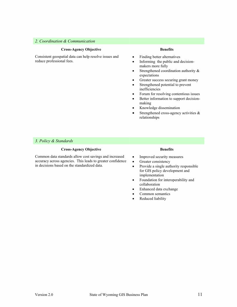
2. Coordination & Communication
Cross-Agency Objective Benefits
Consistent geospatial data can help resolve issues and reduce professional fees.
• Finding better alternatives • Informing the public and decision-
makers more fully • Strengthened coordination authority &
expectations • Greater success securing grant money • Strengthened potential to prevent
inefficiencies • Forum for resolving contentious issues • Better information to support decision-
making • Knowledge dissemination • Strengthened cross-agency activities &
relationships
3. Policy & Standards
Cross-Agency Objective Benefits
Common data standards allow cost savings and increased accuracy across agencies. This leads to greater confidence in decisions based on the standardized data.
• Improved security measures • Greater consistency • Provide a single authority responsible
for GIS policy development and implementation
• Foundation for interoperability and collaboration
• Enhanced data exchange • Common semantics • Reduced liability

Version 2.0 State of Wyoming GIS Business Plan 12
4. Cost Justification
Cross-Agency Objective Benefits
Costs across all agencies using GIS in Wyoming can be reduced by the coordination efforts proposed in this initiative.
• Improved capacity for Cross-Agency Activities
• Less reinventing the wheel (avoidable activity)
• Streamlining inefficient processes • Optimization of resources • Negotiator for Enterprise Licensing
Agreements and Discounts • Lower administrative costs
5. User Needs
Cross-Agency Objective Benefits
Sharing of GIS capabilities will enable more agencies across the state to reap the benefits of GIS that may otherwise miss out on this technology.
• Training & professional development • Answers to GIS technical questions • Increased GIS capacity • Better research & analysis • In-kind contributions • Faster response
In addition to the specific benefits listed in the previous section, there are general benefits that should be noted. The examples listed below are somewhat intangible, and inherently difficult to quantify. And yet, in qualitative terms, the intangible benefits are highly desirable to maintain and enhance Wyoming’s attractiveness and the well-being of its citizens. Though possible to estimate the quantitative value of at least some of these benefits, it is outside the scope of this document to fully quantify the following items:
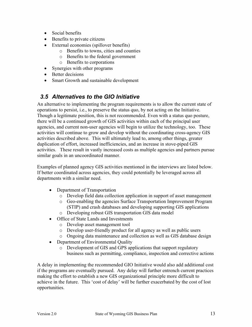
Version 2.0 State of Wyoming GIS Business Plan 13
• Social benefits • Benefits to private citizens • External economies (spillover benefits)
o Benefits to towns, cities and counties o Benefits to the federal government o Benefits to corporations
• Synergies with other programs • Better decisions • Smart Growth and sustainable development
3.5 Alternatives to the GIO Initiative An alternative to implementing the program requirements is to allow the current state of operations to persist, i.e., to preserve the status quo, by not acting on the Initiative. Though a legitimate position, this is not recommended. Even with a status quo posture, there will be a continued growth of GIS activities within each of the principal user agencies, and current non-user agencies will begin to utilize the technology, too. These activities will continue to grow and develop without the coordinating cross-agency GIS activities described above. This will ultimately lead to, among other things, greater duplication of effort, increased inefficiencies, and an increase in stove-piped GIS activities. These result in vastly increased costs as multiple agencies and partners pursue similar goals in an uncoordinated manner. Examples of planned agency GIS activities mentioned in the interviews are listed below. If better coordinated across agencies, they could potentially be leveraged across all departments with a similar need.
• Department of Transportation o Develop field data collection application in support of asset management o Geo-enabling the agencies Surface Transportation Improvement Program
(STIP) and crash databases and developing supporting GIS applications o Developing robust GIS transportation GIS data model
• Office of State Lands and Investments o Develop asset management tool o Develop user-friendly product for all agency as well as public users o Ongoing data maintenance and collection as well as GIS database design
• Department of Environmental Quality o Development of GIS and GPS applications that support regulatory
business such as permitting, compliance, inspection and corrective actions A delay in implementing the recommended GIO Initiative would also add additional cost if the programs are eventually pursued. Any delay will further entrench current practices making the effort to establish a new GIS organizational principle more difficult to achieve in the future. This ‘cost of delay’ will be further exacerbated by the cost of lost opportunities.

Version 2.0 State of Wyoming GIS Business Plan 14
With both a GIO and a supporting TSP in place, GIS activities will become more streamlined and efficient, allowing a build-up of value-added capabilities rather than a continued replication of common activities. With this build-up, new opportunities will become available for optimizing resource reallocation, and pursuing high-value projects and grant money. Without the GIO, these opportunities would not be realized, and the opportunity to both strengthen and streamline statewide GIS activities would be missed.
44 OORRGGAANNIIZZAATTIIOONNAALL AAPPPPRROOAACCHH The State of Wyoming has already recognized the significant role of geographically referenced data and tools. These data and tools are used extensively by many state agencies to better support the planning and management of land, water, and economic resources. Significant cost savings and benefits can be achieved with better coordination and the shared development of critical datasets and technologies. In order to realize these benefits there is a need to implement organizational changes that would be more effective in achieving the efficiency goals. Significant strides have already been made in this direction with the GIS Coordination Structure created by Governor Freudenthal. This includes the Governor appointed Oversight Committee (5 members) and the Technical Advisory Group (14 members). These groups will guide geospatial policy and infrastructure development into the future for the State of Wyoming. It is now proposed that this aforementioned governance structure be extended through the establishment of a full-time Geographic Information Officer and a supporting Technical Services Program (see organizational diagram below). Both the rationale and benefits of these organizational measures are covered by earlier sections of this document. Costs will be addressed in greater detail in Section 5.
Oversight Committee
Technical Advisory
Group (TAG)
GIO
Geospatial Technical Services Program
4.1 Geographic Information Officer (GIO) The State of Wyoming is not alone in pursuing a GIO or similar State GIS Coordinator position. Placement of the GIO in the Office of the CIO is the prevailing national tendency, although this is not the only configuration in states that have a GIO. The need for such a position to effectively and successfully manage and oversee state level GIS activities is well understood and documented. The recently established Federal

Version 2.0 State of Wyoming GIS Business Plan 15
Geographic Data Committee (FGDC) and National States Geographic Information Council (NSGIC) Fifty States Initiative includes nine criteria essential for the effective statewide coordination of geospatial information technologies (see Section 4.4). These criteria were identified through an extensive review of what has worked well to create better results in states across the nation. Of the nine criteria identified, the first speaks to a GIO: “A full-time, paid coordinator position is designated and has the authority to implement the state’s business and strategic plans”. ∗ It is recommended that the State of Wyoming GIO position be established within the State’s Office of Chief Information Officer (OCIO). The GIO position provides technical, geospatial services to other agencies and clients similar to the CIO. As the State of Wyoming builds out an IT Enterprise Architecture, it is important that the geospatial enterprise be fully integrated and partnered with the enterprise architecture. This is best achieved by locating the GIO under the CIO and fostering a close working relationship between IT and geospatial information and technology. The GIO will provide coordination and support activities for many other agencies and departments, and therefore has a synergistic fit within the OCIO.
4.2 Technical Services Program (TSP) The Technical Services Program (TSP) would provide technical support for statewide coordination efforts, as well as specific project support to individual agencies where required. The TSP would be charged with accomplishing the following major activities, with guidance and direction provided by the GIO:
1. Develop an Enterprise Architecture for GIS to support multiple agencies through GIS web services as well as agency specific capabilities
2. Support the development of the spatial data clearinghouse 3. Define and implement statewide spatial data standards 4. Develop spatial metadata 5. Coordinate GIS tool development and maintenance 6. Provide training in technology and data use 7. Provide on-call technical support 8. Provide data maintenance support to authoritative data owners 9. Support the GIO position 10. Develop outreach program to the broader stakeholder community including local
government, federal government and private industry with the objective of further reinforcing data standards and systems interoperability
It is the recommendation of the Wyoming CAP Grant Project Team that the TSP component of this plan be located at the University of Wyoming, Wyoming Geographic Information Science Center (WyGISC). WyGISC was established in 2001 with part of its mission being to advance the application of geographic information science across the State of Wyoming. The center does this through research work, application development, and by providing web access to geospatial data and mapping applications. The center
∗ Sample GIO job descriptions can be found on the NSGIC website (http://www.nsgic.org/resources/index.cfm)

Version 2.0 State of Wyoming GIS Business Plan 16
also provides training and education resources and has provided geospatial support to academia, government, the private sector and the general public.
4.3 Oversight for the GIO Initiative The existing State of Wyoming Oversight Committee will provide executive direction to the GIO who also sits on the Governor appointed Oversight Committee. The GIO will be located in the Office of the Chief Information Officer, reporting to the CIO. The Oversight Committee and the CIO will provide the necessary oversight of the GIO position, and the Technical Advisory Group (TAG) will provide knowledge and expertise to strengthen and support the overall Initiative. The TAG is also a representative cross-section of the key stakeholders. The TSP will be directed by the GIO. Joint operations between the GIO and TSP are considered to be a key success factor for the entire Initiative. To ensure that the proposed program is successful, the CIO and Oversight Committee will provide oversight and mentoring. The GIO will report to the CIO and Oversight Committee on an informal and formal basis, providing progress reports, updated risk assessments, as well as short and longer term planning objectives and status.
4.4 Comparison to Other States: The 50 States Initiative The benefits of a coordinated geospatial strategy are being recognized by other states who are actively attempting to realize them. As part of the 50 States Initiative, the National States Geographic Information Council (NSGIC), in cooperation with the Federal Geographic Data Committee (FGDC), identified nine criteria for success in statewide GIS Programs. These are listed below along with the current status in Wyoming and a count for where these factors are in force in other states. Coordination Criteria∗ Status in
Wyoming States with
Yes response
1. A full-time, paid coordinator position is designated and has the authority to implement the state’s business and strategic plans.
No 29
2. A clearly defined authority exists for statewide coordination of geospatial information technologies and data production.
Yes 40
3. The statewide coordination office has a formal relationship with the state’s Chief Information Officer (or similar office).
Yes 37
4. A champion (politician or executive decision maker) is aware and involved in the process of coordination.
Yes 35
5. Responsibilities for developing the National Spatial Data Infrastructure and a State Clearinghouse are assigned.
No 39
6. The ability exists to work and coordinate with local governments, academia, and the private sector.
Yes 44
7. Sustainable funding sources exist to meet projected needs. No 44
∗ Source is the NSGIC State Information Guide dated March 6, 2006.

Version 2.0 State of Wyoming GIS Business Plan 17
8. Coordinators have the authority to enter into contracts and become capable of receiving and expending funds.
No 30
9. The Federal government works through the statewide coordinating authority.
No 41
The top factors identified as impediments to the State of Wyoming participating fully with the National Map Program were: Factors Impeding participation in National Map Program∗
Value Average Value 1 = strongly agree 5 = strongly disagree
Not enough staff 1 1.96 No time to coordinate 1 2.24 No budget 1 1.86 Statewide coordination efforts need improvement 2 2.36 It is significant to note that the number one criterion for effective coordination is a full-time coordinator position. The State of Wyoming has under-performed, when compared with other states. By having no full-time coordinator with specific authority to oversee a coordinated statewide GIS program, and no sustainable funding for such a position, and no accountability for developing statewide spatial data infrastructure, the State is disadvantaged in reaping the full benefits of GIS.
55 PPRROOGGRRAAMM CCOOSSTTSS Significant benefits will accrue through the purposeful pursuit of the cross-agency objectives listed below (and detailed in Section 3.1, previously). These objectives, and the related requirements, were commonly expressed during the interviews conducted with key officials and stakeholders during November and December of 2006. The objectives are listed here, in order of importance:
1. Data Quality and Sharing 2. Coordination and Communication 3. Policy and Standards 4. Return on Investment 5. User Needs
It is recommended that the cross-agency objectives be actively tackled and achieved by the proposed GIO Initiative. This Initiative will develop the necessary GIS fabric statewide that will better support cross-agency activities with end products being delivered at a reduced cost as well as more quickly and with a much higher potential for reusability. Agencies operating on their own may achieve good approaches to their piece of the problem, but it will likely be a “silo” unto itself, not maximizing the State’s investment for the greatest good. Given that multiple jurisdictions are involved in such
∗ Source is the NSGIC State Information Guide dated March 6, 2006. The National Map is a federal Initiative to establish a national geospatial data framework to support decision-making by resource managers and the public.
Version 2.0 State of Wyoming GIS Business Plan 18
activities, relying on voluntary collaboration is somewhat tenuous, with no accountability.
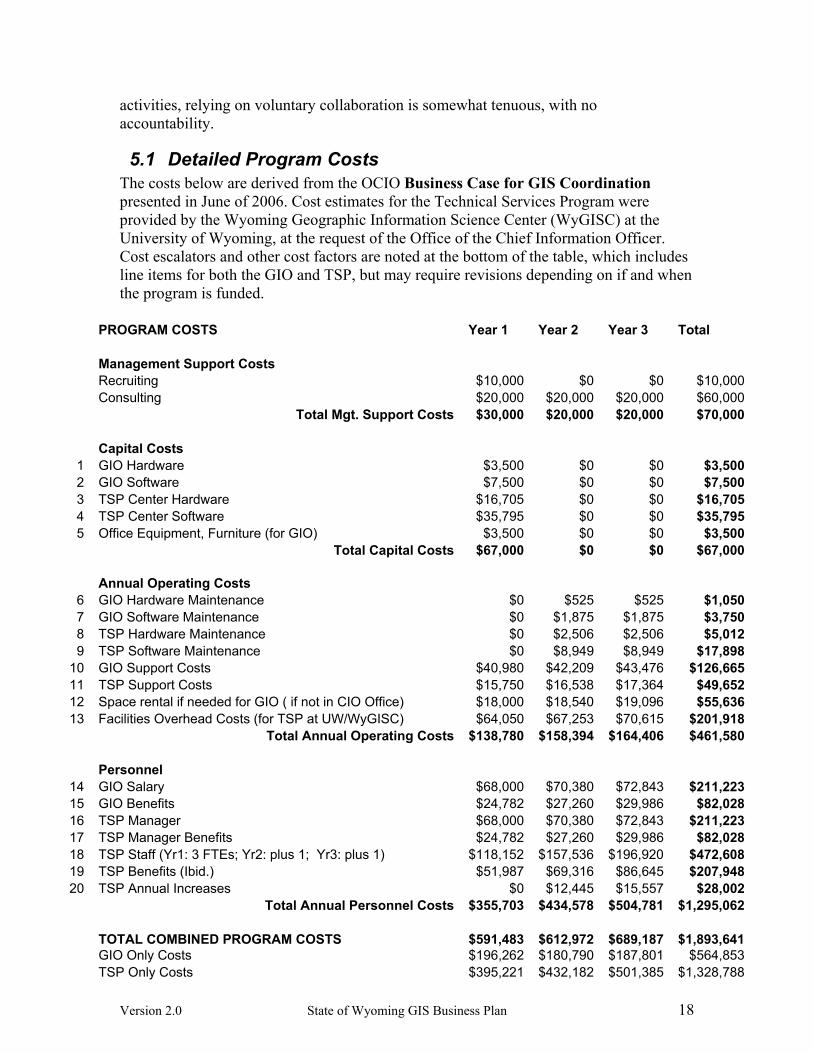
5.1 Detailed Program Costs The costs below are derived from the OCIO Business Case for GIS Coordination presented in June of 2006. Cost estimates for the Technical Services Program were provided by the Wyoming Geographic Information Science Center (WyGISC) at the University of Wyoming, at the request of the Office of the Chief Information Officer. Cost escalators and other cost factors are noted at the bottom of the table, which includes line items for both the GIO and TSP, but may require revisions depending on if and when the program is funded.
PROGRAM COSTS Year 1 Year 2 Year 3 Total Management Support Costs Recruiting $10,000 $0 $0 $10,000 Consulting $20,000 $20,000 $20,000 $60,000 Total Mgt. Support Costs $30,000 $20,000 $20,000 $70,000 Capital Costs
1 GIO Hardware $3,500 $0 $0 $3,5002 GIO Software $7,500 $0 $0 $7,5003 TSP Center Hardware $16,705 $0 $0 $16,7054 TSP Center Software $35,795 $0 $0 $35,7955 Office Equipment, Furniture (for GIO) $3,500 $0 $0 $3,500
Total Capital Costs $67,000 $0 $0 $67,000 Annual Operating Costs
6 GIO Hardware Maintenance $0 $525 $525 $1,0507 GIO Software Maintenance $0 $1,875 $1,875 $3,7508 TSP Hardware Maintenance $0 $2,506 $2,506 $5,0129 TSP Software Maintenance $0 $8,949 $8,949 $17,898
10 GIO Support Costs $40,980 $42,209 $43,476 $126,66511 TSP Support Costs $15,750 $16,538 $17,364 $49,65212 Space rental if needed for GIO ( if not in CIO Office) $18,000 $18,540 $19,096 $55,63613 Facilities Overhead Costs (for TSP at UW/WyGISC) $64,050 $67,253 $70,615 $201,918 Total Annual Operating Costs $138,780 $158,394 $164,406 $461,580 Personnel 14 GIO Salary $68,000 $70,380 $72,843 $211,22315 GIO Benefits $24,782 $27,260 $29,986 $82,02816 TSP Manager $68,000 $70,380 $72,843 $211,22317 TSP Manager Benefits $24,782 $27,260 $29,986 $82,02818 TSP Staff (Yr1: 3 FTEs; Yr2: plus 1; Yr3: plus 1) $118,152 $157,536 $196,920 $472,60819 TSP Benefits (Ibid.) $51,987 $69,316 $86,645 $207,94820 TSP Annual Increases $0 $12,445 $15,557 $28,002 Total Annual Personnel Costs $355,703 $434,578 $504,781 $1,295,062 TOTAL COMBINED PROGRAM COSTS $591,483 $612,972 $689,187 $1,893,641 GIO Only Costs $196,262 $180,790 $187,801 $564,853 TSP Only Costs $395,221 $432,182 $501,385 $1,328,788

Version 2.0 State of Wyoming GIS Business Plan 19
Cost Escalators: Salary increase of 3.5% per year. 3.5% Increased insurance costs of 10% per year. 10.0% Software annual maintenance fees of 25% of license. 25.0% Hardware annual maint. Fees of 15% of purchase. 15.0% TSP support cost increases of 5% per year 5.0% GIO support cost increases of 3% per year 3.0% NOTES:
1) All costs are based on June 9, 2006 Business Case, Wyoming CIO Office, unless noted. 2) Capital Costs are typically depreciated over time, but not in this analysis. 3) GIO space rental cost (if needed) assumes 150 s.f. at $10/s.f. per month
4) Facilities OH cost for TSP at UW/WyGISC discounted to 20% off standard rate, with additional in-kind contributions.
Abbreviations: GIO: Geographic Information Officer TSP: Technical Services Program
FTE: Full Time Equivalent UW: University of Wyoming WyGISC: Wyoming Geographic Information Science Center
5.2 General Costs Not all costs are quantified in the previous section. Below are several items that were beyond the scope of this plan, in terms of quantification. These are typical of scenarios where public investments are being considered.
• Social Costs – these may include the impact of poor or erroneous decisions resulting from insufficient or inaccurate data
• Diseconomies (a.k.a. spillover costs) – these may include the cost of data consumers being compelled to become data producers of commonly needed feature data, with associated inefficiencies and sub-optimal resource allocation
• Sunk Costs (which are ignored in cost-benefit analysis, based on industry practices) – these may include investments already made , and for example, might include existing data, software, and hardware
5.3 Risk Assessment The following potential risks have been identified for the proposed program: Risk
Probability
Impact
Overall Risk
Risk Mitigation
Previous efforts to establish a GIO and TSP Office have not been successful.
2 4 High
This business plan provides a clear exposition of the cost benefits of a GIO and TSP Office. Both qualitative and quantitative

Version 2.0 State of Wyoming GIS Business Plan 20
benefits need to be effectively communicated. This business plan includes an education strategy to mitigate the risk.
Insufficient funding allocation for GIO and TSP Office 2 3 High
Sufficient and long-term funding needs to be secured. It is critical that the early successes are effectively communicated and realized benefits are quantified and leveraged.
Dedicated staff resources not sufficient to meet all objectives 2 3 High
As the role of the GIO and TSP Office matures realistic objectives need to be established based on available resources.
Insufficient support in State Legislature 2 4 High
The proposal to establish and fund a GIO position in December, 2006, was not fully supported. This business plan includes a marketing plan to help with outreach and education.
Lack of awareness and support from senior executive staff 1 1 Low
The interviews completed during the development of this plan indicated a high level of senior executive support.
GIS stakeholders fail to fully participate in the program 2 3 High
It will take time for agencies to develop a level of confidence in both the GIO and TSP Office. Mitigation includes the setting of realistic expectations for the entire stakeholder community.
* Risk Probability and Impact:
1 = Low, 3 = Medium, 4 = High
Overall risk assessment was determined using the probability/impact matrix shown here. The level of risk is continually changing and an effective means of measuring and responding to the changing risks and risk levels will need to be established as the program is implemented.

Version 2.0 State of Wyoming GIS Business Plan 21
66 IIMMPPLLEEMMEENNTTAATTIIOONN PPLLAANN This implementation plan calls for a three year plan for the full establishment of a Geographic Information Officer and a Technical Services Program.
6.1 Three Year Implementation Plan
Year 1 Year 2 Year 3
Activity Q1-2 Q3-4 Q1-2 Q3 - 4 Q1-2 Q3-4
Geographic Information Officer (GIO)
Establish GIO position within the CIO Office Develop comprehensive objectives in cooperation with Oversight Committee and Technical Advisory Committee
Implement outreach program Commence data holdings inventory Commence the development of statewide data standards
Oversee the build-out of a GIS data clearinghouse Oversee the development of an Enterprise level GIS architecture
Technical Services Program (TSP) Establish TSP Staff Locate and resource the TSP Develop comprehensive objectives in cooperation with GIO, Oversight Committee and Technical Advisory Committee
Commence Providing Technical Support Initiative outreach program Initiative training program Establish technical and data infrastructure able to support broader enterprise level GIS activities
6.2 Programmatic Scorecard The programmatic scorecard provides a quantitative mechanism for determining what level of progress has been achieved over time. Assessing progress against proposed ‘targets’ provides a ready means to determine the current success level. If necessary, adjustments to the implementation strategy can be made, based on progress. Below is a preliminary scorecard for the defined programmatic goals. These can be modified and extended as appropriate. On a predefined schedule, it is recommended that the set of tasks be reviewed and the checklist updated to reflect task completion. Totaling the number of checklist points enables a percentage estimate to be made against the target 81 points, for checking status.

Version 2.0 State of Wyoming GIS Business Plan 22
Programmatic Goal Establish a dedicated Geographic Information Officer (GIO) position within the State’s Office of the Chief Information Officer
CROSS-AGENCY Objectives
TASKS
Tota
l Poi
nts
Cur
rent
Sco
re
CHECKLIST
Dat
a Q
ualit
y an
d S
harin
g
Coo
rdin
atio
n &
C
omm
unic
atio
n
Pol
icy
and
Stan
dard
s
Cos
t Jus
tific
atio
n
Use
r Nee
ds
Establish GIO position within the CIO Office 6
Obtain funding approval (2 points) Post Job (1 point) Interview Candidates (1 point) Position is filled (2 points)
Develop comprehensive objectives in cooperation with Oversight Committee and Technical Advisory Group (TAG) 13
Develop short, medium, and long term coordination and planning objectives (1 point)
Assign priorities and develop oversight and management protocols (1 point)
Obtain Oversight Committee and TAG approval (2 point)
Initiate short-term activities (1 point) Initiate medium term activities (1
point) Initiate long term activities (1 point) Accomplish short term objectives (2
points) Accomplish medium term objectives
(2 points) Accomplish long term objectives (2
points)
Implement outreach program
4
Meet with all appropriate agency representatives to develop a state-of-the-state GIS use and needs picture (2 points)
Establish Intranet based website for the sharing of GIS related news and information (2 points)
Commence data holdings inventory 3
Meet with all appropriate agency representatives to develop a state-of-the-state GIS data holdings inventory (2 points)
Develop and publish data holding catalog (1 point)
Commence the development of statewide data standards
8
Review federal and other state data standards and specifications (1 points)
Establish strategies, procedures and protocols for the development of Wyoming GIS data standards, e.g., are standards proposed and established through data working groups? How are state agencies to be involved? What are the requirements for compliance? (2 points)

Version 2.0 State of Wyoming GIS Business Plan 23
Programmatic Goal Establish a dedicated Geographic Information Officer (GIO) position within the State’s Office of the Chief Information Officer
CROSS-AGENCY Objectives
TASKS To
tal P
oint
s
Cur
rent
Sco
re
CHECKLIST
Dat
a Q
ualit
y an
d S
harin
g
Coo
rdin
atio
n &
C
omm
unic
atio
n
Pol
icy
and
Stan
dard
s
Cos
t Jus
tific
atio
n
Use
r Nee
ds
Identify constituency and assess likelihood of adoption (1 point)
Prioritize and develop short-term and longer-term objectives (1 point)
Publish data standards (1 point) Establish support mechanisms
(resource support, other), that will help agencies adopt the standards (2 points)
Oversee the build-out of a GIS data clearinghouse 6
Locate hardware and purchase software (2 points)
Program portal (1 point) Load data inventory content and
extended metadata (1 point) Publish metadata clearinghouse (2
points)
Oversee the development of an Enterprise level GIS architecture
6
Develop RFP for Systems Design (1 point)
Complete Systems Architecture Design and Implementation Strategy including short and long term requirements and objectives (2 points)
Develop RFP for Systems Development (1 point)
Develop Enterprise GIS Architecture (2 points)
TOTAL POINTS 46 0

Version 2.0 State of Wyoming GIS Business Plan 24
Programmatic Goal Establish a Technical Services Program (TSP) for GIS support CROSS-AGENCY Objectives
TASKS
Tota
l Poi
nts
Cur
rent
Sco
re
CHECKLIST
Dat
a Q
ualit
y an
d S
harin
g
Coo
rdin
atio
n &
C
omm
unic
atio
n
Pol
icy
and
Stan
dard
s
Cos
t Jus
tific
atio
n
Use
r Nee
ds
Establish TSP Staff
7
Obtain funding approval for positions and associated costs (2 points)
Develop position descriptions, roles, and responsibilities (1 point)
Post Jobs (1 point) Interview Candidates (1 point) Positions are filled (2 points)
Locate and resource the TSP
4
Identify TSP Office location (1 point) Identify TSP Office resource
requirements (hardware/software) (1 point)
Equip TSP (2 points)
Develop comprehensive objectives in cooperation with GIO, Oversight Committee and Technical Advisory Committee
6
Develop TSP office short (1 year) and long term (3-5 year) objectives (1 point)
Obtain Oversight Committee and TAG approval and establish mandate (2 point)
Initiate short-term activities (1 point) Accomplish short term objectives (2
points)
Commence Providing Technical Support
2
Establish protocols for the provision of technical support including reporting (1 point)
Establish infrastructure for the provision of technical support, e.g., 800 telephone number, work request tracking, (1 points)
Initiate outreach program
5
Enhance Intranet based website for the sharing of GIS related news and information – enhance existing capability with technical support information as well as a forum for the sharing technical tips and suggestions (2 points)
Initiate agency/site visitation schedule (1 point)
Meet with agency GIS users to describe role of TSP and services offered (2 points)
Initiate training program 7
Develop Introduction to GIS Training Program (1 points)
Develop Advanced GIS Training Program (1 point)
Develop Business Specific GIS

Version 2.0 State of Wyoming GIS Business Plan 25
Programmatic Goal Establish a Technical Services Program (TSP) for GIS support CROSS-AGENCY Objectives
TASKS To
tal P
oint
s
Cur
rent
Sco
re
CHECKLIST
Dat
a Q
ualit
y an
d S
harin
g
Coo
rdin
atio
n &
C
omm
unic
atio
n
Pol
icy
and
Stan
dard
s
Cos
t Jus
tific
atio
n
Use
r Nee
ds
Training Program (2 points) Develop Program Schedule (1 point) Commence providing training (2
points)
Establish technical and data infrastructure able to support broader enterprise level GIS activities
4
Support the development of a statewide GIS Enterprise infrastructure through participation in systems design and specification (1 point)
Develop protocols and procedures for maintaining enterprise architecture components (1 point)
Provide operational and on-going support for the enterprise architecture (1 point)
Provide technical and other support to agencies utilizing the enterprise architecture (1 point)
TOTAL POINTS 35 0
Use the table below to monitor progress towards establishing a functional GIO and TSP able to support the broader state-level GIS needs in an effective and coordinated manner.
Progress Matrix
Total Points
March 07
June 07
Sept. 07
Dec. 07
March 08
June 08
Sept. 08
Dec. 08
Establish Geographic
Information Officer (GIO)
46
Establish a Technical Services
Program (TSP) 35
TOTALS 81 Use the table below to score your overall progress. This will give some indication of the current level of success. Clearly, the successful integration of the GIO Initiative into the fabric of the state business operations is a complex and involved activity, which at any point in time will have both successful and less successful aspects. Quantitative metrics need to be accompanied by a narrative description, to ensure a complete and comprehensive report. This report should be provided to the Oversight Committee on a regular basis. The table above assumes a quarterly reporting schedule.

Version 2.0 State of Wyoming GIS Business Plan 26
Long way to Go Needs Improvement Successful Total Points 0-50 50-74 75-81
6.3 Funding Plan The explicit goal is to obtain state funding for both the GIO position. Establishing sustainable funding for the GIO Initiative is one of the nine Criteria for judging the success of a state’s GIS program. Achieving this will strengthen Wyoming’s ability to compete for and win grant money as well (e.g., FGDC CAP grants, and DHS Geospatial Preparedness grants). The Governor’s GIS Coordination Structure specifies that the state’s Office of the Chief Information Officer (OCIO) will be the administrative authority.
6.4 Education and Outreach Conducting outreach about the GIO Initiative and its benefit to improving decision-making at multiple levels is a critical component for success. Essentially, a concerted effort to inform affected stakeholders about how they can be involved and benefit from this Initiative must be prioritized. At the same time, creating general “buzz” and appreciation for the ways this technology will enhance communities and their service and planning needs must be considered. A separate document has been prepared to expand upon the State of Wyoming GIS Business Plan Education Strategy, and the outline below is a high-level summary. A. Message Development
1) Create substantive messages articulating: a) Value (e.g., will save time and money) b) Progress (e.g., will allow better, more cutting edge decisions to be made) c) Trust (e.g., show understanding and respect for stakeholders)
2) Create talking points for GIO and anyone testifying to the benefits of GIS in improving business processes, e-Government, and decision-making support
B. Define Target Audiences. There are levels of importance when it comes to target
audiences. The top priority group comprises decision-makers (both those who decide how GIS is used and those who decide what resources to supply to the effort). A second priority group is more focused on external influencers/communicators, such as the media.
1) Audiences: The GIO must be prepared to communicate progress, activity and
resource availability internally to: i) Senior level agency managers and decision makers ii) Agency GIS users iii) Potential and new GIS users
2) External Audiences:

Version 2.0 State of Wyoming GIS Business Plan 27
i) Wyoming media ii) State agencies iii) Town and county administrators, elected officials iv) Wyoming legislative leaders v) Other – as the GIO Initiative gets more traction, and progresses from one year
to the next, the message can be refined and extend to additional local governments and business leaders
C. Collateral development
1) Develop logo, visual “brand” of GIO Initiative to build awareness of new services
2) Power point presentation with demonstrations, illustrations 3) Succinct case studies 4) “Leave-behind” brochure highlighting applications in non-technical way
D. Communication vehicles
1) Media relations: press releases and editorial boards with Wyoming media (newspaper, radio, television). Releases would be distributed to stakeholders (e.g., partner agencies, GIS community, local, state and federal agencies), community colleges and the University of Wyoming, etc.
2) Website a) Overview of services and vision b) Eventually used to communicate availability of data, standards, and
opportunities to work on projects of mutual interest. 3) List serves of GIS community, state and federal agencies
E. Workshops & Seminars
1) Develop whitepaper from case study, use as curriculum basis demonstrating application
2) Provide hands-on training at seminars 3) Speeches, presentations at board meetings, conferences, annual meetings of:
a) Joint Appropriations Committee b) Wyoming Association of Municipalities c) Wyoming Association of County Commissioners d) Wyoming Mining Association, Wyoming Petroleum Association e) Wyoming Heritage Society f) Wyoming Association of Law Enforcement g) Wyoming Medical Society/Dept. of Health h) Natural Resources Conservation Districts / Soil Conservation Districts
F. Site visits or GIO-convened meeting with “power users”
1) University of Wyoming, WyGISC, Community Colleges 2) Department of Transportation 3) BLM, USFS, USGS state offices 4) Oil and Gas Conservation 5) Department of Environmental Quality 6) Legislative Services 7) Office of State Lands and Investments

Version 2.0 State of Wyoming GIS Business Plan 28
8) Wyoming Game and Fish Department 9) Wyoming Business Council
G. Special Events and Partnerships. While the first 12 – 18 months of the GIO’s
outreach efforts should emphasize a focus on informing agencies, users and partners about the specific services being offered, there are many exciting possibilities for raising awareness about GIS technology and applications in the future. Options include:
a. Outreach for special projects, e.g., “Ag in the Classroom” b. GIS Day at the Legislature or Governor’s GIS and Mapping Day c. Partnership with Wyoming Mediation Program d. Mentoring Program for agencies e. Mentoring “Scholarship” Program
NOTE: As the Program is fine-tuned during implementation, the specifics of the Education Strategy should be adjusted to reflect those modifications and the preferences of the GIO.

Version 2.0 State of Wyoming GIS Business Plan 29
77 AAPPPPEENNDDIICCEESS
1. Executive Order 2006 – 1, dated April 18, 2006 – formation of the Wyoming GIS Coordination Structure
2. List of Interviewees 1. Executive Order 2006-1 This is available on the State of Wyoming Governor’s website. See: http://wyoming.gov/governor/press_releases/execorder/2005/documents/ExecOrder2006-1.pdf 2. Interview List and Questionnaire As part of the effort to author this Business Plan, Applied Geographics, Inc., and Flitner Communications (Consultant Team) completed a number of interviews to better understand the needs of the broad set of stakeholders as well as their current use of GIS technology. The information gleaned from these meetings was further enhanced with details captured in a questionnaire that was also provided to the interviewees. The list of interviewees and interview dates are noted below: Agency or Organization Interviewee Interview Date USGS, Central Region GIO Cheryl Morris 12/19/06 Department of Transportation Ben Saunders 12/19/06 Department of Health Tracy Lindsten 12/11/06 Department of Environment Quality Marcelo Calle 12/5/06 Wyoming Division of Tourism Rod Morris 12/5/06 US Forest Service Jane Darnell 12/04/06 Governor’s Office Mary Flanderka 12/4/06 Bureau of Land Management Renee Duval, Mary Wilson 11/24/06 Office of State Lands Lynne Boomgaarden, Kenneth
Flack (Assistant IT Director), Susan Childs (Interim Deputy Director), Judy Edgar (GIS User), Bill Holgensen (Forestry Division GIS user)
11/22/06
Association of Municipalities George Parks 11/21/06 Office of Homeland Security Joe Moore, Jim Case 11/20/06