WIRELESS SENSOR NETWORK APPLICATIONS IN COLD …
21
WIRELESS SENSOR NETWORK APPLICATIONS IN COLD ALPINE AREA OF WEST CHINA: EXPERIENCES AND CHANLLENGES Chen Hao, Nan Zhuotong Cold and Arid Regions Environmental and Engineering Research Institute of Chinese Academy of Sciences, Donggang West Road 320, Lanzhou, China Emails: [email protected] Submitted: Sep. 29, 2012 Accepted: May 14, 2013 Published: June 5, 2013 Abstract- Wireless sensor network (WSN) shows unique advantages in cold alpine area comparing with traditional in-situ monitoring approaches. This paper presents two WSN applications in cold alpine area, one in the Hulugou watershed and the other in the Babaohe watershed, both of which are situated in the upper mountainous reach of the Heihe River Basin of West China. Apart from introductions to the two WSN applications and experimental results, experiences learned and challenges met during designing, testing and deployment of WSN are discussed. The paper concludes a promising future of WSN in environment monitoring in cold alpine areas. Index terms: Wireless sensor network (WSN), cold alpine area, environment monitoring, eco-hydrology, Heihe River Basin. INTERNATIONAL JOURNAL ON SMART SENSING AND INTELLIGENT SYSTEMS VOL. 6, NO. 3, JUNE 2013 932
Transcript of WIRELESS SENSOR NETWORK APPLICATIONS IN COLD …

WIRELESS SENSOR NETWORK APPLICATIONS IN COLD
ALPINE AREA OF WEST CHINA: EXPERIENCES AND
CHANLLENGES
Chen Hao, Nan Zhuotong
Cold and Arid Regions Environmental and Engineering Research Institute of Chinese Academy
of Sciences, Donggang West Road 320, Lanzhou, China
Emails: [email protected]
Submitted: Sep. 29, 2012 Accepted: May 14, 2013 Published: June 5, 2013
Abstract- Wireless sensor network (WSN) shows unique advantages in cold alpine area comparing with
traditional in-situ monitoring approaches. This paper presents two WSN applications in cold alpine
area, one in the Hulugou watershed and the other in the Babaohe watershed, both of which are
situated in the upper mountainous reach of the Heihe River Basin of West China. Apart from
introductions to the two WSN applications and experimental results, experiences learned and
challenges met during designing, testing and deployment of WSN are discussed. The paper concludes a
promising future of WSN in environment monitoring in cold alpine areas.
Index terms: Wireless sensor network (WSN), cold alpine area, environment monitoring, eco-hydrology,
Heihe River Basin.
INTERNATIONAL JOURNAL ON SMART SENSING AND INTELLIGENT SYSTEMS VOL. 6, NO. 3, JUNE 2013
932
I. INTRODUCTION
In present days of accelerated global climate change, ecologically fragile regions such as cold
alpine areas have drawn increasing attention. Environmental monitoring and ecological
protection has been given high priority in this region as the environment is extremely susceptive
to climate change. However, field works in cold alpine areas are proved to be difficult and time-
consuming as most of the sites are hard to reach. To facilitate environmental monitoring in such
areas, new and effective technology gets applied [1]. Wireless sensor networks (WSN) were
regarded as one of the most promising technologies in 21st century with outstanding advantages
such as simple and easy deployment, long-term monitoring, less human intervention, and small,
controllable, efficient and energy-saving system [2]. WSN applications to physically hard
environment such as cold alpine areas will greatly mitigate problems encountered with traditional
approaches, like huge man-power, high maintenance cost, and intensive field work. Literature
review shows that the first WSN application for environmental monitoring appeared ten years
ago [3]. In recent years, many studies had extended the WSN application to various fields and
different environments. For example, Beutel [4] had set up a kind of sensor interface boards,
known as PermaDAQ, to fit in an extreme environment in mountain permafrost region. Although
trial deployment had shown that the system exhibited superior functionalities compared with
traditional sensor networks, the data quality and system endurance still needs to be improved.
Generally speaking, maintenances shall be with a minimum frequency when WSNs are deployed
in a remote and hard to reach area. However, as inevitable annual snowfall or other severe
climatic conditions in cold alpine areas always lay heavy burdens on the system, it will in fact
encounter more damages and demand more maintenances compared with those in friendly
environment. Thus, all WSN deployments in extreme environment shall face and try to solve
such dilemma. Different solutions have been made on those issues, and various kinds of
algorithms and software packages are developed to make WSN more reliable, efficient and robust.
Cold and Arid Regions Environmental and Engineering Research Institute of Chinese Academy
of Sciences (CAREERI/CAS) has set up two WSN applications to monitor hydrological and
ecological variables in the non-populated Qilian mountains of West China. Based on those works,
following sections will describe general information of the two applications and summarize
experiences and lessons learned, as well as challenges we are facing. In section II, geographic
Chen Hao and Nan Zhuotong, WIRELESS SENSOR NETWORK APPLICATIONS IN COLD ALPINE AREA OF WEST CHINA: EXPERIENCES AND CHANLLENGES
933

and environmental features of the study areas were described. General WSN deployment practice
and experimental results were elaborated. In sections III and IV, experiences learned from our
practices and challenges that may be encountered in future studies were discussed. In section V,
conclusions about current practices and future WSN development were drawn.
II. WSN APPLICATIONS IN COLD ALPINE REGION
a. Hulugou Watershed
The Hulugou watershed(99º50′E-99º54′E, 38º12′N-38º17′N), with an area of around 23.1 km2, is
drained by a tributary of the Heihe River and situated in the Qilian county of Northwest China.
The elevations in this watershed range from 2960 to 4820 m. It is climatically within the cold
region of China and vegetated with sparse and cold/drought resistant species [5]. Annual air
temperature varies from -25 to 15 Celsius degree. There are 6 glaciers in the Hulugou watershed.
A complete eco-hydrological observatory system has been set up in this watershed as a result of
several research projects conducted by CAREERI/CAS. As a part of the system, a WSN targeted
to automate and intensify temperature, humidity and radiation observation has been deployed.
Figure 1 displays its location within the entire Heihe river basin and its terrain conditions.
Figure 1. Location and terrain of the Hulugou watershed [6]
INTERNATIONAL JOURNAL ON SMART SENSING AND INTELLIGENT SYSTEMS VOL. 6, NO. 3, JUNE 2013
934

An area of 400 m by 400 m at the entrance of the Hulugou watershed was chosen and divided
into 100 m by100 m grids. After a series of laboratory testing and on-site testing, onboard sensors
were set up to measure air temperature, relative humidity, radiation intensity, soil temperature
and soil moisture in each grid. Data were collected at a prescribed interval and transmitted to
nearby base station routed by a number of relay stations. The base station is responsible for
remote node management as shown in Figure 2.
Figure 2. WSN deployment in the Hulugou watershed
b. Babaohe Watershed
The Babaohe watershed is located in the upstream area of the Heihe river basin. The river within
the Babaohe watershed is 105 km long with a drainage area of around 2452 km2 and an
altitudinal range of 2640 to 5000m. It is of continental alpine climate and covered primarily with
nature meadow like alpine meadow, grassland and others. Annual temperature varies from -30 to
20 Celsius degree. Annual precipitation is between 270 to 600 mm. Perennial snow coverage and
permanent glaciers are discovered above 4200 m. Permafrost is distributed above 3600 m. The
Babaohe watershed is an ideal site for cold region hydrology and remote sensing experiment. A
set of observational instruments have been set up within this area as shown in Figure 3.
Chen Hao and Nan Zhuotong, WIRELESS SENSOR NETWORK APPLICATIONS IN COLD ALPINE AREA OF WEST CHINA: EXPERIENCES AND CHANLLENGES
935

Figure 3. Current observational instruments in the Babaohe watershed
Figure 4. Architecture of eco-hydrological WSN in the Babaohe watershed
INTERNATIONAL JOURNAL ON SMART SENSING AND INTELLIGENT SYSTEMS VOL. 6, NO. 3, JUNE 2013
936

Figure 5. Automatic data exchange between regional center and the remote Lanzhou data server
An IPv6 based eco-hydrological WSN was designed to enhance existing instruments to obtain
accurate precipitation, soil moisture content, soil temperature and snow cover data in an
automation manner. After sufficient testing, the WSN has been officially put into use beginning
August 2011. The successful deployment of eco-hydrological WSN in Babaohe watershed will
offer convenient tools in exploring the water-heat process in alpine-cold region of west China.
The eco-hydrological WSN in the Babaohe watershed is based on 3-layer architecture,
comprising of monitoring nodes, regional data server and the remote Lanzhou data center which
brings together all sources of varied data besides those from WSN and is connected with WSN
through Internet. A node management and data visualization system has been developed, residing
in the three regional data servers and the remote data server in Lanzhou. With this system,
researchers are able to monitor node status and manipulate nodes as well as to view incoming
data in a visualized manner. The nodes, collecting meteorological, hydrological and ecological
data with calibrated sensors, will transmit data wirelessly to regional data server. Monitoring
nodes have been configured to accept remote commands from regional data server and remote
Chen Hao and Nan Zhuotong, WIRELESS SENSOR NETWORK APPLICATIONS IN COLD ALPINE AREA OF WEST CHINA: EXPERIENCES AND CHANLLENGES
937

data center to return real time status and change their behaviors accordingly. Moreover, regular
remote upgrading on nodes can also be configured on server. Upon a connection requested from
nodes, the server will send necessary updated version information to nodes. A comparison
between the latest version number with the current version number on individual node will
confirm the upgrading process. After the confirmation, new version will be sent from server to
the nodes and upgrading will be started automatically. Architecture of the system is shown in
Figure 4. The WSN nodes will update data in real time manner with the regional data server and
then the latter synchronizes with the remote data server located in Lanzhou. The mechanism of
data exchange between regional data server and remote Lanzhou data center is shown in Figure 5.
c. Experimental results
After successful deployments of WSNs in the Hulugou and Babaohe watersheds, reliable data has
been transmitted back to Lanzhou center since October 2010 in Hulugou and August 2011 in
Babaohe.
In the Hulugou watershed, a sensor node coded as Node2 was taken to show the running of WSN.
Node2 was deployed near the entrance of the Hulugou watershed. The topology of Node2 can be
seen in Figure 6. Data were collected by Node2 and then went through the deployed WSN to
reach the remote data center in Lanzhou. The data acquired include air temperature, relative
humidity, radiation intensity, soil temperature and soil moisture content. Soil temperature and
moisture sensors were installed at the depth of 15cm. The variations of soil temperature and air
temperature based on daily average and hourly average data are shown in Figure 7. Figure 7a
shows that in January 2011, soil temperature decreased with air temperature at a slow speed
while soil temperature kept higher than air temperature. In February, soil temperature increased
with air temperature at a slow speed and was finally surpassed by air temperature. The overall
variation amplitude of soil temperature was smaller than air temperature, reflecting the real local
situation. Figure 7b elaborates the diurnal variation of air temperature and the slightly fluctuated
soil temperature on the first day of 2011. To date, experimental results have confirmed the
performance and robustness of the deployed WSN and reliability of transmitted data, just as
showed in Figure 7a and Figure 7b.
INTERNATIONAL JOURNAL ON SMART SENSING AND INTELLIGENT SYSTEMS VOL. 6, NO. 3, JUNE 2013
938

Figure 6. Network topology of WSN in the Hulugou watershed[7]
Figure 7. Variations of soil temperature and air temperature in the Hulugou watershed collected
by the sensor Node2 (a) from 1/01/2011 to 2/28/2011 on daily average data, and (b) in 1/01/2011
on hourly average data
Chen Hao and Nan Zhuotong, WIRELESS SENSOR NETWORK APPLICATIONS IN COLD ALPINE AREA OF WEST CHINA: EXPERIENCES AND CHANLLENGES
939

In the second testing watershed, namely the Babaohe watershed, we have deployed 45 nodes for
eco-hydrological monitoring, including variables such as soil temperature and moisture, air
temperature and humid, precipitation and snow cover. The network comprises of intensive spatial
and temporal observations of soil and micro-meteorology in a watershed scale. The node
distribution can be seen in Figure 8. In the Lanzhou data center, a data visualization and online
management system has been developed to implement semi-realtime monitoring as well as
remote device control for the Babaohe WSN (Figures 9 and 10). The statuses of node devices are
monitored at a 5 minutes interval to ensure a quick response to any incident (Figure 9). The data
visualization interface enables a semi-realtime visualization of data coming from the WSN nodes
at a prescribed time interval (Figure 10). Currently the system has only Chinese version available.
Figure 8. Distribution of 45 nodes for eco-hydrologic study making up the WSN in the Babaohe
watershed
INTERNATIONAL JOURNAL ON SMART SENSING AND INTELLIGENT SYSTEMS VOL. 6, NO. 3, JUNE 2013
940

Figure 9. Device status monitoring interface in the data visualization and online management
system for the Babaohe eco-hydrological WSN (presently only Chinese version available)
Figure 10. Online data monitoring in the data visualization and online management system for
the Babaohe eco-hydrological WSN (presently only Chinese version available). The plot shows
soil temperature at 2cm and 10cm acquired by the WSN from 01/01/2013 00:00 to 01/08/2013
00:00 (UTC+8)
Chen Hao and Nan Zhuotong, WIRELESS SENSOR NETWORK APPLICATIONS IN COLD ALPINE AREA OF WEST CHINA: EXPERIENCES AND CHANLLENGES
941
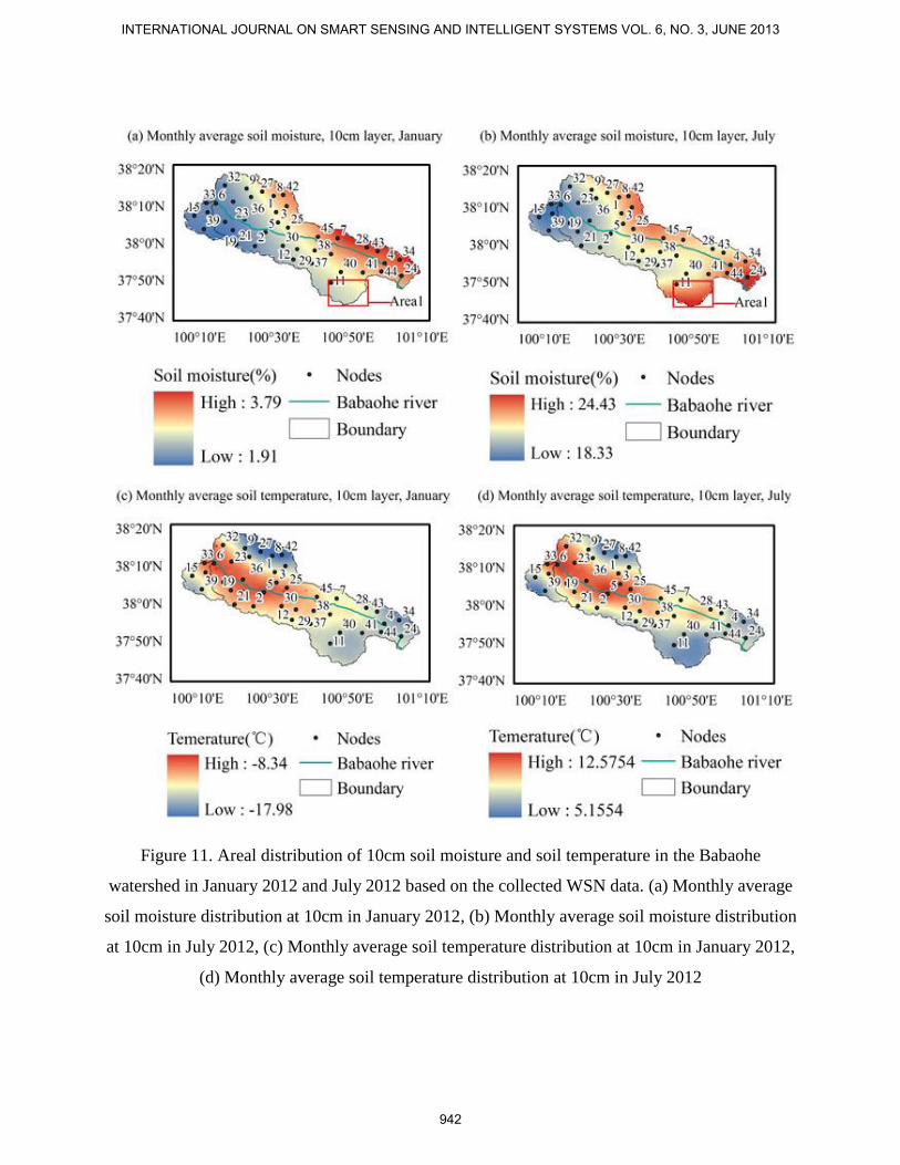
Figure 11. Areal distribution of 10cm soil moisture and soil temperature in the Babaohe
watershed in January 2012 and July 2012 based on the collected WSN data. (a) Monthly average
soil moisture distribution at 10cm in January 2012, (b) Monthly average soil moisture distribution
at 10cm in July 2012, (c) Monthly average soil temperature distribution at 10cm in January 2012,
(d) Monthly average soil temperature distribution at 10cm in July 2012
INTERNATIONAL JOURNAL ON SMART SENSING AND INTELLIGENT SYSTEMS VOL. 6, NO. 3, JUNE 2013
942

Because of its dense node distribution, it is possible to make spatial maps for acquire variables.
For example, Figure 11 presents seasonal variation of monthly average soil moisture and soil
temperature at the depth of 10cm in the Babaohe watershed based on the data acquired by the
Babaohe WSN. The figure was depicted with the Kriging interpolation method at a one kilometer
resolution. As Figure 11 shows the distribution of 10cm soil moisture in January 2012, the
Area1(Figure 11a) as indicated was one of the areas with lower moisture content, while in July
2012, Area1 (Figure 11b) changed into one of the areas with higher moisture content. By looking
at the seasonal precipitation changes, the spatial heterogeneity like that presented in Area1 was
related to the spatially uneven seasonal precipitation pattern in a cold and arid alpine mountain
area. By contrast, the 10 cm soil temperature distribution presented (Figures 11c, d) a much
similar spatial pattern in the Babaohe watershed for different seasons. The 10cm soil temperature
in January 2012 was largely lower than that in July 2012 and areas with lower temperature in
January 2012 were also lower in July. Such basic findings are consistent with what we
understand in this mountainous area from previous studies and prove usefulness of WSN with
unprecedented spatial and temporal resolutions
III. EXPERIENCES
From designing, testing to in situ installation and debugging of WSNs in cold alpine areas, we
have encountered a lot of problems and learned many lessons. Great efforts have been made to
ensure the link quality of network, reliability and integrity of data under extreme environment.
Besides that, lowering total cost, energy efficiency and afterwards maintenance were also our
concerns. In this section, we outlined a number of considerations and lessons learned from our
practices.
a. Resistance to cold alpine conditions
The largest challenge posed by cold alpine area is the extremely low temperature. The endurance
of sensors to subzero temperature is critical to the success of the outdoor deployment. In both
deployments we used industrial level chips for sensors, which carry a RTC module with crystal
oscillator and can ensure sound performance between -40 to 40 Celsius degrees. Those designs
also guarantee an accurate system time.
Chen Hao and Nan Zhuotong, WIRELESS SENSOR NETWORK APPLICATIONS IN COLD ALPINE AREA OF WEST CHINA: EXPERIENCES AND CHANLLENGES
943
The purchased hardware should meet the requirements of the Ingress Protection 67 standard for
outdoor conditions. All equipment was tightly sealed. Electronic parts should have enough
resistance to low temperature, dust, humidity, lightning and animal destruction. Considering the
possible heavy snow in the working area, resistance to pressure and instant impact were also
important. Instruments above the land surface were put into instrument shelter. To avoid
malfunction of sensors caused by temperature fluctuation, heat insulation cover was used. Prior
to outdoor deployment, laboratory testing was carried out to evaluate the overall performance of
the system.
b. Robustness
It was reported that simple and unidirectional data flow can ensure best network robustness [8]. If
nodes bear too heavy calculation loads, data reliability and network robustness cannot be
guaranteed. Thus node burden should be balanced. Another concern is the balance between data
transmission and energy consumption on each node. For physically hard environment, robustness
is of critical importance because manual maintenance usually means very high human and
financial costs. In our cases, data sizes were relatively small, only necessary calculations are kept
at each node so as to ensure long-term stability of network. To study the connectivity of networks
in a long distance, assessment tools such as “SCALE” shall be considered in future studies [9].
“SCALE” can make simple connectivity assessment based on package delivery counting in lossy
environments. As a fact, our knowledge is still insufficient about how the topographic and
climatic factors will affect network connectivity, package loss still happen occasionally under
those extreme environmental conditions. Further studies with SCALE as an assessment tool are
quite necessary.
c. Synchronization
Generally, the time synchronization between nodes is achieved by a simple algorithm based on
temperature variation. Neighbor nodes will be synchronized with closest sink nodes. This “soft”
approach works well under moderate temperature fluctuation situations and is economically
efficient. However, for the cold alpine sites with large temperature fluctuation, it is hard to
achieve accurate time synchronization by this approach. In our WSN application in the Babaohe
INTERNATIONAL JOURNAL ON SMART SENSING AND INTELLIGENT SYSTEMS VOL. 6, NO. 3, JUNE 2013
944

watershed, a GPS module was added to each node to address the synchronization issue. Each
node will make its time synchronized with satellite at given time slots.
d. Storage
Storage capacity and duration have to be considered to address potential network failure. In our
both cases, data increment is not high and 6 months nodal data storage is sufficient. After a
careful comparison among varied products, Samsung NAND 1GB flash memory was adopted.
The major concern is its excellent built-in data integrity checking mechanism. By this
mechanism, new data will be written twice, and the later writing will compare the former writing
for integrity. When writing failure occurs, the bad storage page will be flagged and a new storage
page will be allocated as replacement. Data can only be stored when no error is found in integrity
checking process. Such checking process will greatly enhance data security at the cost of
performance decrease. However, it is suitable for our WSN cases.
All acquired data will be stored in the NAND Flash memory until becoming full. Then new data
will overwrite old one. 1GB is sufficient to hold data for 6 months in our cases. The architecture
of its memory is shown in Figure 12.
Figure 12. Architecture of the memory
e. Node routing
Aware of mountainous topography of the two sites, distance between nodes can vary from tens to
hundreds meters, therefore multi-hop wireless network was adopted. Even so nodes and relays
malfunctioned occasionally. This posed a challenge to us to design a well-organized network
topology and routing scheme accounting for topographic condition. Excessive data flow at a
single node and long distance between nodes may lead to poor link quality [10]. In our design of
Chen Hao and Nan Zhuotong, WIRELESS SENSOR NETWORK APPLICATIONS IN COLD ALPINE AREA OF WEST CHINA: EXPERIENCES AND CHANLLENGES
945

a dynamic network routing, a node will keep track of connection quality information of
neighboring nodes so that it will avoid routing to irresponsible nodes. Besides, each node keeps
multi-hop information to the targeted data sink node to optimize routing calculation. Static
routing to the backbone is not preferred. A dynamic routing is built upon network connectivity
status and quality. An optimal dynamic routing is much energy efficient compared with static
one.
f. Working frequency
Power efficiency in cold alpine environment is much critical. Insufficient solar radiation may
lead to insufficient energy supply from solar panels, causing unexpectedly data collection stop
[11]. Flexible collection frequency setting was introduced to minimize power consumption.
Frequency adjustment was manipulated remotely; the working frequency is generally set to low
unless an intensified data recording is needed. For example, in order to match satellite
observation, the observation will be intensified at the time of satellite pass. Events such as a
heavy precipitation will also raise collection frequency.
g. Multiple interfaces and multiple communication approaches
It is necessary to take into account multiple interfaces and multiple communication approaches
for a WSN deployment in terrain complex areas [12]. Communication means largely determines
efficiency and reliability of wireless communication. Radio transmission may be the primary
power consumer [13]. For example, GPRS has faster transmission speed than GSM, in other
words, GPRS is more power efficient than GSM for transferring same size of data. However,
different communication protocols have their own advantages in different transferring distance
and in crossing complex terrain conditions. In the design stage, we have to choose appropriate
protocols by carefully considering data loading, transmission distance and topography. In both
applications, the recording system used is equipped with five serial ports, five 16-pin IO ports
and sixteen 12-pin ADC, which enable linking with most types of sensors. Different
communication protocols are chosen according to the actual terrain conditions, distance between
node and base station, collection items and data loading.
(1) For a short distance transmission, 2.4G Zigbee wireless network is used. This system is
featured with short distance, low complexity, self-organization, low energy consumption, low
INTERNATIONAL JOURNAL ON SMART SENSING AND INTELLIGENT SYSTEMS VOL. 6, NO. 3, JUNE 2013
946

data transmission rate and low cost. Data exchange between nodes and the wireless module
and its control are implemented by Zigbee APIs (Application Programming Interface).
Independent power management is set for the wireless module to avoid power accident.
(2) For areas reached by mobile signal, GPRS (General Packet Radio Service) is preferred.
Communication between base station and server is implemented by the GPRS module.
Communication between GPRS and sensors is programmed by the AT command through
serial ports. Independent power management is also set for this module.
(3) For areas without mobile signal coverage, radio wave is used instead. This is useful especially
in mountainous areas. The maximum transmission distance is up to 90 km, which might be
shortened due to terrain or building obstacles.
(4) For transference of large data such as images and videos, a microwave module is equipped,
by which transmission distance can be up to over ten kilometers.
(5) A VPN channel is used between each regional data servers and central remote data server to
ensure real time data arrival to the central data center. However, in the current stage, we are
using Internet connection from the regional data server to the Lanzhou central data center.
h. System integration
When WSNs are deployed in the cold alpine area, issues such as system incompatibility,
unexpected malfunction, relevant calibration and upgrading issues may happen frequently [14,
15]. To deal with those problems, some proposed to develop their own integrated system to meet
specific needs, including customized hardware, well-organized network topology, network
protocol and even data structure [16]. Many attempts have been made in past researches.
PermaDAQ [4], a system developed for permafrost monitoring on cold alpine sites, stands for a
good example. To address the challenges confronted such as extremely low temperature and
complex terrain condition, PermaDAQ used customized sensors, master board, as well as
improved multi-hop protocol. As reported, the integrated PermaDAQ performed pretty well for
permafrost monitoring purpose, although there still exist some issues, such as allocating voltage
of master board in a more efficient manner.
In our applications, the embedded operating system ZKOS was used as the underlying platform,
based on which tools and facilities were developed for cold alpine environment use. Commercial
Campbell instruments and own-made wireless sensors were then integrated into this platform.
Chen Hao and Nan Zhuotong, WIRELESS SENSOR NETWORK APPLICATIONS IN COLD ALPINE AREA OF WEST CHINA: EXPERIENCES AND CHANLLENGES
947

Plus, node management and data visualization were added. To achieve better performance, we
believe that more efforts should be made to tailor hardware, software and systematic integration.
To ensure compatibility between different software versions, a version control mechanism was
introduced during the development stages. Compared to general WSN, WSN for cold alpine area
need more efforts on reducing redundant nodes, increasing transmission capabilities of each
node, and simplifying codes and network topology. With such design, the WSN is expected to
work normally at least 1 to 3 years without site maintenance.
IV. CHALLENGES AND DISCUSSIONS
a. Synchronization
The most desirable working temperature for the quartz clock on each node is 25 Celsius degree.
Other working temperature may lead to timing deviation. Time calibration and synchronization
are necessary for WSN deployed in a cold alpine area. In our current applications, an additional
GPS module is equipped to improve time synchronization. However, it is not an ideal solution
because of the extra cost and accuracy dependency on GPS connectivity quality. A “soft”
solution may be preferred, that is, to develop powerful synchronization algorithms, rather than
using additional hardware, to calibrate time to acceptable accuracy.
b. Energy consumption
Generally speaking, radio transmission is the biggest power user in WSN. In our current design, a
hibernation/awaking-up mechanism was adopted to minimize power consumption. However,
better network protocols and algorithms in reducing duty cycle are expected in the future. On the
other hand, energy efficient hierarchical clustering algorithm [17] also appears to be a research
hotspot. The principle of the algorithm is to divide the WSN sensors into different clusters, so
that information transfer can only happen between “cluster heads” of each cluster. A carefully
and reasonably designed hierarchy of cluster heads can generate considerable energy saving,
which makes clustering algorithm development a hopeful direction. Moreover, along with the
development of 3G technology, network performance would be obviously improved in terms of
data transmission efficiency, connectivity quality and data loading, which makes “smart” node
possible. A smart node means more tasks will be calculated on the node side and data
INTERNATIONAL JOURNAL ON SMART SENSING AND INTELLIGENT SYSTEMS VOL. 6, NO. 3, JUNE 2013
948

transference over the network will be less. By this means, the power consumption of data
transmission will be greatly reduced.
c. Cost control and technical development
The fast development of WSN benefits from fast development of microcontroller, sensors, radio
appliances and battery [18, 19]. Nowadays, those factors still constrain the extension of WSN
applications in different scopes and make large-scale WSN with hundreds of sensors onboard
unrealistic for financial and technical reasons. Because WSN is not a broad market to attract
more commercial investments, we need to bring potential developments from other fields into
WSN. 3G technology and new energy are most promising areas that might accelerate the
development of WSN. Another attempt is to develop simple and useful software frameworks
aiming at minimizing expertise needed in WSN development and deployment, which is helpful to
a wide group of scientists who lack sophisticate computer skills from programming to hardware
design. The philosophy of such applications is “keep it simple” as well as “make it effective and
efficient”. In the past time, the Tiny Application Sensor Kit (TASK) [20], a system designed for
end-users in sensor network deployment and management, is one of the most successful systems
in this direction and has attracted many followers. Developed by the support of the TinyOS
community, TASK can greatly reduce the requirement and complexity of general WSN
deployment and management with its compacted service kit, convenient portal interface and
acceptable remote management accuracy. Based on such works, Barrenetxea [21, 22] has
developed SensorScope. SensorScope has employed multiple gateways and integrated the whole
workflow within a real-time Google Maps-based Web interface. With such functionalities, it can
greatly reduce the costs and complexity of the whole WSN systems with favorable adaptability to
difficult environment. Although challenges such as sensor calibration still need better solution, it
has already opened an optimistic direction and showed great potential in the future.
V. CONCLUSIONS
As a newly emerged and promising technology, WSN applications in cold alpine areas with
physically hard conditions is proved to be successful. Our applications in both the Hulugou
watershed and Babaohe watershed have acquired successive and reliable data. It shows that WSN
Chen Hao and Nan Zhuotong, WIRELESS SENSOR NETWORK APPLICATIONS IN COLD ALPINE AREA OF WEST CHINA: EXPERIENCES AND CHANLLENGES
949
has great potential in watershed-scale environmental monitoring, especially for areas with
extreme physical conditions and hard to reach. The merits are obvious. It has greatly reduced
maintenance overhead. However, there are still some challenges worthy of more efforts input
including time synchronization, power consumption and cost control as discussed in this paper.
The broadening use of WSN depends on not only the network related technical progresses, but
also the successful integration with other fields. In earth science, WSN is significant complement
to existing observation system and can satisfy the requirements of intensified observation. Data
acquired from WSN, together with other site observations, air-borne and satellite data, are able to
create systematic, standardized and reliable data sets, which would be valuable for watershed-
scale eco-hydrological research.
ACKNOWLEDGMENTS
The authors would like to thank financial support from the Hi-tech grant of Chinese Science and
Technology Minister (2008AA12Z205) and CAS innovation progromme (KZCX2-YW-Q10-1).
We thank Prof. Rui Jin and Prof. Weizhen Wang for their strong supports to the Babaohe
watershed case study.
REFERENCES
[1] L. Selavo, A. Wood, Q. Cao, T. Sookoor, H. Liu, A. Srinivasan, Y. Wu, W. Kang, J.
Stankovic, D. Young and J. Porter, “LUSTER: wireless sensor network for environmental
research”, Proc. of the 5th ACM Conference on Embedded Networked Sensor Systems, pp. 103-
116, Sydney, Australia, Nov. 6-9, 2007.
[2] J. K. Hart and K. Martinez, “Environmental sensor networks: a revolution in the earth system
science”, Earth-Science Reviews, Vol. 78, No. 3-4, pp. 177-191, October 2006.
[3] P. Gong, “Wireless sensor network as a new ground remote sensing technology for
environmental monitoring”, Journal of Remote Sensing, Vol. 11, No. 4, pp. 545-551, July 2007.
[4] J. Beutel, S. Gruber, A. Hasler, R. Lim, A. Meier, C. Plessl, I. Talzi, L. Thiele, C. Tschudin,
M. Woehrle and M. Yuecel, “PermaDAQ: A scientific instrument for precision sensing and data
INTERNATIONAL JOURNAL ON SMART SENSING AND INTELLIGENT SYSTEMS VOL. 6, NO. 3, JUNE 2013
950

recovery in environmental extremes”, 2009 International conference on Information Processing
in Sensor Networks, IPSN 2009, pp. 265-276, San Francisco, USA, Apr. 13-16, 2009.
[5] R. S. Chen and C. T. Han, “Hydrology, ecology and climate significance and its research
progress of the alpine cold desert”, Advance in Earth Science, Vol. 25, No. 3, pp. 255-263,
March 2010.
[6] W. P. Zhu, Y. N. Zhang and L. H. Luo, “Study and application of the wireless sensor network
to eco-hydrology”, Journal of Glaciology and Geocryology, Vol. 33, No. 3, pp. 573-581, June
2011.
[7] Y. N. Zhang, L. H. Luo, J. Y. Huo and W. P. Zhu, “An eco-hydrology wireless sensor
demonstration network in high-altitude and alpine environment in the Heihe River Basin of
China”, Wireless Sensor Network, Vol. 4, No. 5, pp.138-146, May 2012.
[8] H. Abrach, S. Bhatti, J. Carlson, H. Dai, J. Rose, A. Sheth, B. Shucker, J. Deng and R. Han,
“MANTIS: System support for multimodal networks of In-situ Sensors”, Proc. of the 2nd ACM
International Workshop on Wireless Sensor Networks and Applications, WSNA 2003, pp. 50-59,
San Diego, USA, Mar. 22-24, 2003.
[9] A. Cerpa, N. Busek and D. Estrin, “SCALE: A tool for simple connectivity assessment in
lossy environments”, CENS Technical Report # 21, pp. 1-16, 2003.
[10] W. Y. Fu, D. S. Li, J. Chen, Y. Y. Han and J. G. Nie, “Topology optimization control with
balanced energy and load in underwater acoustic sensor networks”, International Journal on
Smart Sensing and Intelligent Systems, Vol. 4, No. 1, pp. 138-159, March 2011.
[11] P. Juang, H. Oki, Y. Wang, M. Martonosi, L. Peh and D. Rubenstein, “Energy-efficient
computing for wildlife tracking: design tradeoffs and early experiences with Zebranet,” ACM
Sigplan Notices, Vol. 37, No. 10, pp. 96-107, October 2002.
[12] A. Arora, P. Dutta, S. Bapat, V. Kulathumani, H. Zhang, V. Naik, V. Mittal, H. Cao, M.
Demirbas, M. Gouda, Y. Choi, T. Herman, S. Kulkarni, U. Arumugam, M. Nesterenko, A. Vora
and M. Miyashita, “A line in the sand: a wireless sensor network for target detection,
classification, and tracking”, Computer Networks, Vol. 46, No. 5, pp.605-634, December 2004.
[13] T. W. Sung, T. T. Wu, C. S. Yang and Y. M. Huang, “Reliable data broadcast for Zigbee
wireless sensor networks”, International Journal on Smart Sensing and Intelligent Systems, Vol.
3, No. 3, pp. 504-520, September 2010.
Chen Hao and Nan Zhuotong, WIRELESS SENSOR NETWORK APPLICATIONS IN COLD ALPINE AREA OF WEST CHINA: EXPERIENCES AND CHANLLENGES
951
[14] A. Hasler, I. Talzi, J. Beutel, C. Tschudin and S. Gruber, “Wireless sensor networks in
permafrost research:concept, requirements, implementation, and challenges”, 9th International
Conference on Permafrost, pp. 669-674, Fairbanks, USA, Jun. 29-Jul. 3, 2008.
[15] K. Martinez, P. Padhy, A. Elsaify, G. Zou, A. Riddoch, J. K. Hart and H. L. R. Ong,
“Deploying a sensor network in an extreme environment”, IEEE International Conference on
Sensor Networks, Ubiquitous, and Trustworthy Computing, Vol. 1, pp. 186-193, Tai Chung,
Taiwan, Jun. 5-7, 2006.
[16] K. Aberer, M. Hauswirth and A. Salehi, “A middleware for fast and flexible sensor network
deployment”, Proc. of the 32nd International Conference on Very Large Databases, pp. 1199-
1202, Seoul, South Korea, Sep. 12-15, 2006.
[17] S. Bandyopadhyay and E. J. Coyle, “An energy efficient hierarchical clustering algorithm
for wireless sensor networks”, Proc. of the Conference on Computer Communications, IEEE
INFOCOM 2003, Vol. 1-3, pp. 1713-1723, San Francisco, USA, Mar. 30-Apr. 3, 2003.
[18] P. Corke, T. Wark, R. Jurdak, H. Wen, P. Valencia and D. Moore, “Environmental wireless
sensor networks”, Proceedings of the IEEE, Vol. 98, No. 11, pp. 1903-1917, November 2010.
[19] A. Rahman and S. Asokan, “Fiber Bragg grating sensors: new ideas on strain-temperature
discrimination”, International Journal on Smart Sensing and Intelligent Systems, Vol. 3, No. 1,
pp. 108-117, March 2010.
[20] P. Buonadonna, D. Gay, J. M. Hellerstein, W. Hong and S. Madden, “TASK: Sensor
network in a box”, Proceedings of the Second European Workshop on Wireless Sensor Networks,
pp. 133-144, Istanbul, Turkey, Jan. 31-Feb. 2, 2005.
[21] G. Barrenetxea, F. Ingelrest, G. Schaefer, M. Vetterli, O. Couach and M. Parlange,
“Sensorscope: Out-of-the-box environmental monitoring”, Proc. of the International Symposium
on Information Processing Sensor Networks, pp. 332-343, St Louis, USA, Apr. 22-24, 2008.
[22] F. Ingelrest, G. Barrenetxea, G. Schaefer, M. Vetterli, O Couach and M. Parlange,
“SensorScope: Application-specific sensor network for environmental monitoring”, ACM
Transactions on Sensor Networks, Vol. 6, No. 2, pp. 1-32, February 2010.
INTERNATIONAL JOURNAL ON SMART SENSING AND INTELLIGENT SYSTEMS VOL. 6, NO. 3, JUNE 2013
952