What is GIS? - About Us | Department of...
29
Transcript of What is GIS? - About Us | Department of...


What is GIS?
People Software
Data
Procedures
Hardware
Network
Chapter 1

Five Ms of Applied GIS
•Mapping •Measuring •Monitoring •Modeling •Managing
Why use GIS?
Chapter 2

Why GIS? Geography matters Quantitative analyses matter GIScience, GISystems, GISociety
Chapter 1

GIS integrates disciplines and technologies such as remote sensing, surveying,
photogrammetry, spatial analysis, cartography, computer science.
GIS integrates disciplines.

Georeferencing
Geography integrates data.
Chapters 5 and 9 (e.g.)

GIS data: Spatial & aspatial
GIS is “an information technology which stores, analyses, and displays both spatial and non-spatial data” (Parker 1988).
Attribute linkages
Spatial data
P,L,A,Px
Attribute data
NOIR
Chapters 3 and 8

Forest Non-Forest
Reality
Vector representation
GIScience: Objects and fields
Fuzzy Raster representation
Full membership (Forest)
No membership (Non-Forest)
Chapters 4, 6 and 8

Moving from files to databases
Views provide for dis-association of the
data from the presentation Chapter 10
Views
SQL enables dis-association from the software specifics

GISystem: software components
Input
Analyses
Storage & Manipulation
Output
GIS is “a powerful set of tools for collecting, storing, retrieving at will, transforming and displaying spatial data from the real world” (Burrough 1986).

GISystems and Society
Filter Knowledge
Filter Mandates
Software tools
Geographic database
Geographic Information System
Real world User
Cartographic generalization Purpose / intent of producer
Data models
GIS is “a decision support system involving the integration of spatially referenced data in a problem-solving environment” (Cowen 1988)
Chapters 1, 6 and 10
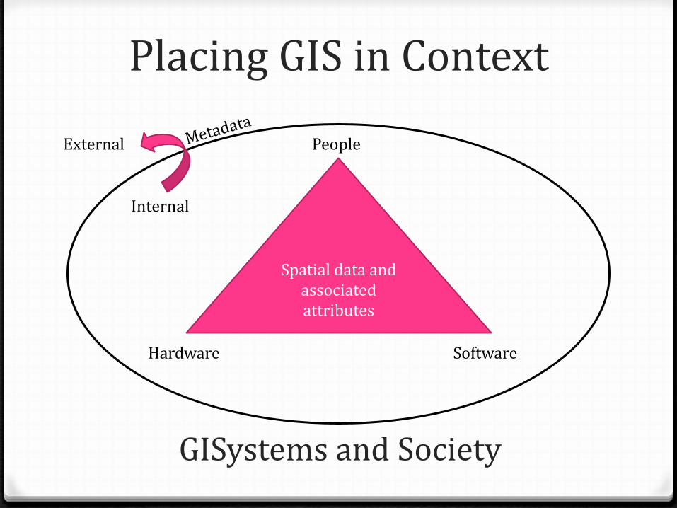
Placing GIS in Context
Internal
External
Spatial data and associated attributes
Hardware
People
Software
GISystems and Society
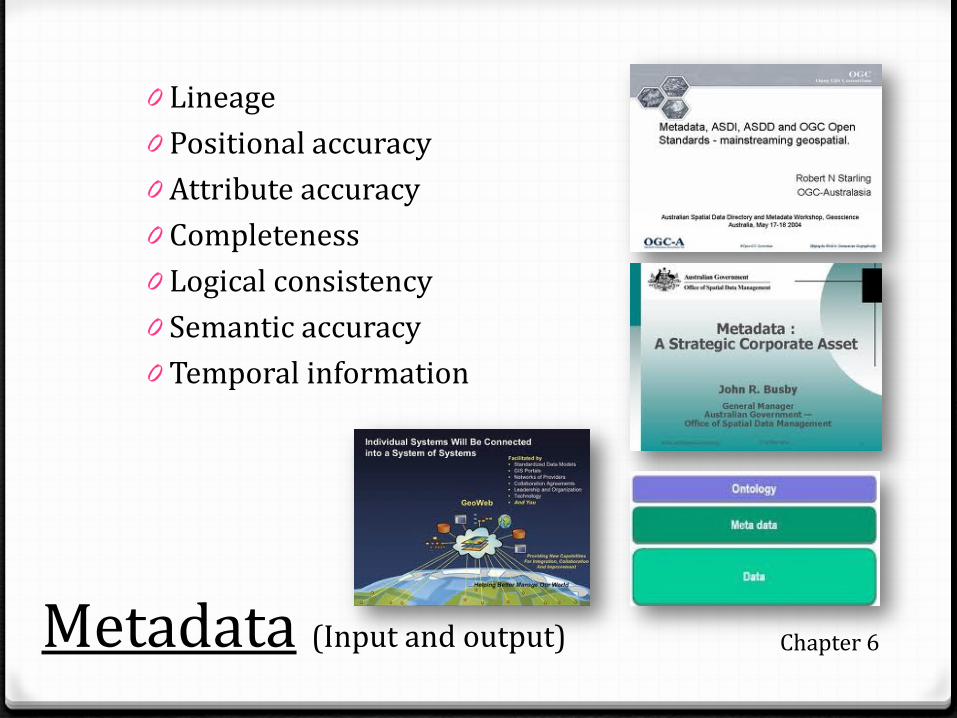
Metadata (Input and output)
0 Lineage 0 Positional accuracy 0 Attribute accuracy 0 Completeness 0 Logical consistency 0 Semantic accuracy 0 Temporal information
Chapter 6

Output: Map design criteria
Chapters 12 and 13
Real world Conceptualization Measurement & representation Analysis
Interpretation, validation & exploration
Layer properties
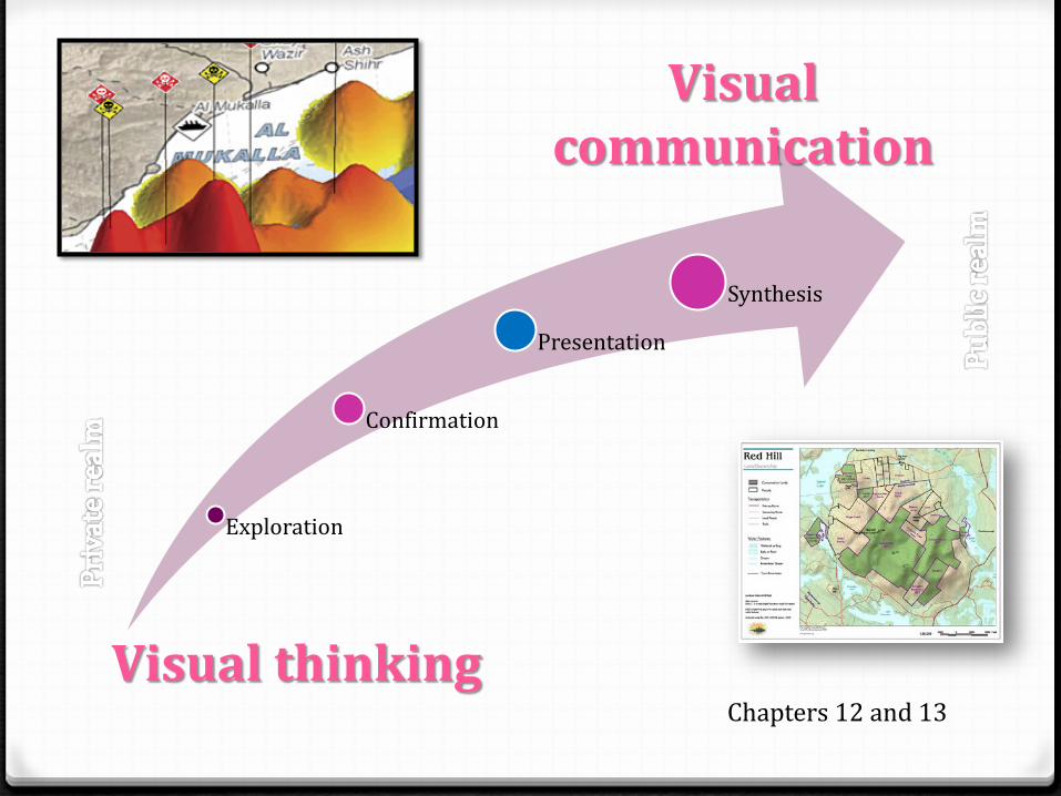
Exploration
Confirmation
Presentation
Synthesis
Visual thinking
Visual communication
Chapters 12 and 13

Analyses: GIS aids understanding
http://www.physorg.com/news71850513.html Chapters 14 and 15
Spatial statistics overview Spatial analyst overview
Equivalent ranges Meaningful weights
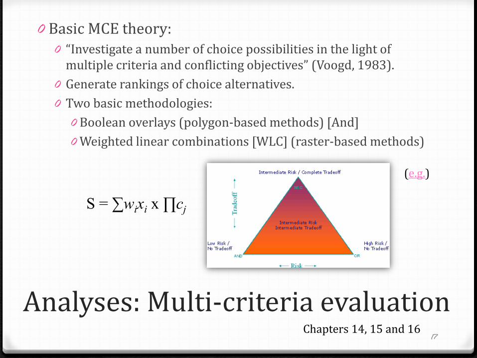
Analyses: Multi-criteria evaluation
0 Basic MCE theory: 0 “Investigate a number of choice possibilities in the light of
multiple criteria and conflicting objectives” (Voogd, 1983). 0 Generate rankings of choice alternatives. 0 Two basic methodologies:
0 Boolean overlays (polygon-based methods) [And] 0 Weighted linear combinations [WLC] (raster-based methods)
17
S = ∑wixi x ∏cj
Chapters 14, 15 and 16
(e.g.)

Analyses: Spatial interpolation Geostatistical analyst overview: http://www.ce.utexas.edu/prof/maidment/giswr2005/geostat/GeostatisticExercise.htm
Local / global Exact / approximate
Stochastic / deterministic Abrupt / smooth
Chapters 14, 15 and 16
Geostatistics IDW

Uncertainty
Analyses: Spatial interpolation
No one ‘right’ answer, although some will be more right than others
Know your data
Chapters 14, 15 and 16

Analyses: Spatial interpolation
If we ignore (or do not have) samples from the stream, the interpolated surface will not be very representative.
Know your data
Chapters 14, 15 and 16
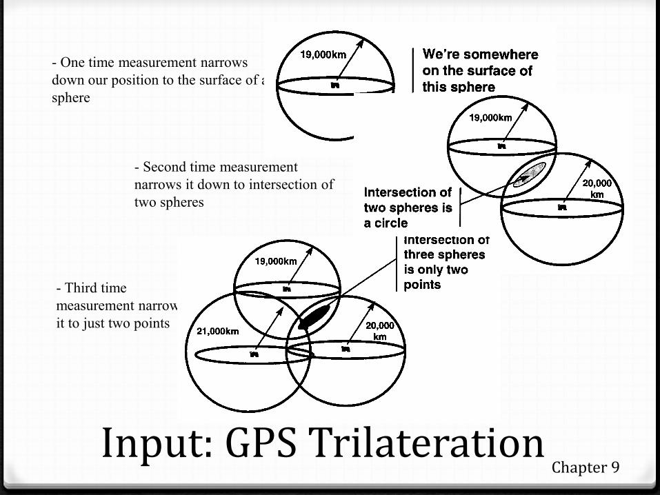
Input: GPS Trilateration
- One time measurement narrows down our position to the surface of a sphere
- Second time measurement narrows it down to intersection of two spheres
- Third time measurement narrows it to just two points
Chapter 9

Input: Remote sensing
Source
Platform Sensor
Active/passive
Object
Chapter 9

Input: Remote sensing 0 Spectral, spatial, temporal, radiometric resolution 0 Panchromatic to multispectral to hyperspectral 0 Classification (supervised vs unsupervised) 0 Pan sharpening, orthorectifying 0 Applications (e.g., NDVI)
Chapter 9
Spectral signatures

Terms and Definitions
• Projection-based coordinate systems • Coordinate Systems (Albers, UTM) • Projections (Datums: geoid ellipsoid plane )
• Objects / Fields • Spatial Entities (PLAPx) • Topology • Scale / Resolution (e.g.) • Generalization • Uncertainty • Measurement levels (NOIR) • Primary / Secondary data (source)

Textbook readings
Chapters 1– 6, 8-10, 12 – 16, 21 were covered in the classes.
Chapter 7 provides an overview of the history and
current state of GISoftware (vendors, functionality), while Chapter 11 covers the GeoWeb.
Chapters 17-20 cover management and policy issues.
Reviewing the lecture notes will be important.

Exam
Dec 6 @ 3:30 Geog 200 2.5 hours Write on one side of the page Assume 1 mark / minute of writing Email me if you would like to arrange a meeting to
review anything. [email protected]

Exam Format
0 Part 1 Definitions 0 Part 2 Short answer questions 0 Part 3 Essay questions 0 Material will cover the entire term 0 Emphasis on understanding, although providing
examples (i.e., material from labs, projects) will be beneficial.

What next? 0 Geob 372 Cartography 0 Geob 372 Remote Sensing 0 Geog 374 Statistics 0 Geob 479 GIScience in Research 0 Directed Studies 0 BCIT / Masters

Best of luck in your exams