Watershed Detectives - USU
22
1 NR/WQ/2011-7 Students (6-12) analyze water samples from different watersheds and use their knowledge of water quality to determine the source of their samples. Watershed Detectives
Transcript of Watershed Detectives - USU

1 NR/WQ/2011-7
Students (6-12) analyze water samples from different watersheds and use their knowledge of water quality to determine the source of their samples.
Watershed Detectives

2
PURPOSE: To describe and identify the link between land use activities and water quality. OBJECTIVES:
Understand how different land uses within a watershed (for example urban, agricultural, mining or recreation) may affect the quality of the water draining from that watershed.
Use simple water testing procedures to measure turbidity, pH, and nitrates in streams. Interpret water quality data to better understand the potential impact and possible
source of pollution; Learn about “best management practices” for different land uses that can control or prevent contamination of water resources in these watersheds.
SUMMARY: Simple solutions are prepared ahead of time by the instructor. Before the lesson, several water samples are made to reflect conditions in a fictional watershed. Students are given a description of each fictional watershed, including their unique land uses. Students are also given the spiked water samples from each of these watersheds. The students test the water samples for turbidity, pH, and nitrates and are given information about the temperature and dissolved oxygen levels in each sample. Students interpret the water quality data and land use clues to match the water samples to the watersheds. Students also discuss approaches to improving or protecting water quality in different settings.
BACKGROUND: A watershed is an area of land from which all the water drains to the same location, such as a stream, pond, lake, river, wetland or estuary. A watershed can be quite large, such as the Colorado River drainage basin, or very small, such as a small horse pasture that drains to a farm pond. Watersheds are “nested”, with many small watersheds comprising larger watersheds. Watersheds are comprised of upland areas, riparian areas (the strips of water loving vegetation near streams, lakes and other water bodies), and the streams, lakes and wetlands that collect and transport the water and anything carried by the water.
The natural conditions of a watershed, such as its elevation, annual precipitation and temperature, native geology and plant communities will all determine the quality of the water leaving that watershed. “Point sources” of pollution are discharges from industries or waste water treatment plants and may be significant in some areas. In many watersheds, however, streams and lakes are more affected by “nonpoint pollution” which enters primarily from rain and snowmelt runoff over the land surfaces. The amount and types of pollutants are determined by the land uses and activities in a watershed. Different types of land uses and activities, such as roads and urban development, mining, timber harvesting, recreation, and agricultural activities, may result in quite different mixes and amounts of pollutants. Non-point source pollution is associated with rainfall and snowmelt runoff moving over and through the ground, carrying natural and human made pollutants into water sources. Examples of non-point source pollutants are fertilizers, pesticides, sediment, gas, and oil.
Pollutants such as nutrients, pesticides, oil and gas products, salts, sediment and bacteria can drastically alter the state of the stream or lake’s ecosystem. If we can determine the type of pollutant and its source, we can take preventative measures to reduce any further contamination.

3 NR/WQ/2011-7
Students will make the following measurements on each water sample:
Turbidity: Turbidity tells us how much suspended material (such as sediment or microorganisms) is in the water. Suspended sediment eventually settles out in a stream and fills in the spaces between the rocks and gravel on a stream bottom. This can suffocate the tiny aquatic animals living between the rocks or the fish eggs laid on stream bottoms. Turbidity can also prevent sunlight from reaching aquatic plants and may also affect the ability of fish and aquatic invertebrates to see and capture their prey. Turbidity increases naturally when flows increase, but also increases from uncontrolled runoff from agricultural fields, roads and trails or construction sites.
Nitrate (NO3): This is the most common form of inorganic nitrogen in unpolluted waters. It is an essential nutrient for plant and animal growth. However, increased amounts of nitrate can lead to excessive plant growth which can decrease the aesthetic value of water bodies (by making it murky, smelly or creating a slimy bottom). The decomposition of this extra plant material also uses up oxygen in streams and lakes, resulting in fish kills. Sources of nitrate include fertilizers, animal waste and failing septic systems. pH: This is a measurement of how acidic or basic something is. pH is measured on a scale from 0 to 14 with 7 being neutral. The lower numbers on the scale are more acidic, while the higher numbers are more basic. The pH scale is logarithmic, which means each unit change (e.g., from 7 to 8) in pH represents a 10-fold change in the acidity.
Students will also be given information on other measurements that are more difficult to modify in a classroom setting. These include:
Dissolved Oxygen: This is not the bubbles in water, or the oxygen part of the H20 water molecule. It is a separate oxygen molecule that is dissolved into water. It gets into the water either by oxygen from the atmosphere mixing into a river where there is turbulence, or by aquatic plants realeasing oxygen during photosynthesis. Fish and aquatic macroinvertebrates require a certain level of dissolved oxygen in order to survive.
Temperature: The temperature of water is the amount of heat energy it contains. Temperature can be measured in Fahrenheit or Celsius. Since state requirements are usually in Celsius, that is the preferred scale for testing water samples.
MATERIALS:
Watershed sketches/clues (see page 10) 6 plastic jugs (e.g. rinsed gallon milk bottles) for water samples Modeling clay or fine silt/soil Vinegar or Lemon Juice *Sodium nitrite (or fish tank water) *Turbidity tubes *pH strips *Nitrate kits

4
Water Quality Sampling Data Sheet (see page 18) 1 per student or group Utah’s Requirements Sheet (see page 19) 1 per group Turbidity Conversion Chart (see page 20) 1 per group Pencils *Nitrate kits, turbidity tubes, and pH strips can be borrowed from county extension offices free of charge. For contact information see https://extension.usu.edu/waterquality/htm/educator-resources/equip. For suggestions on where to buy these materials, see http://extension.usu.edu/waterquality/htm/educator-resources/equip/list/. Sodium nitrite can be obtained free of charge from Utah State University Water Quality Extension in Logan (for contact information see https://extension.usu.edu/waterquality/htm/contact) or purchased from a chemistry store. Fish tank water is also an excellent source of nitrates. PREPARING WATER SAMPLES: These measurements are for 1 gallon water samples. Measurements are estimates and may vary due to differences in tap water. Gold Creek High Turbidity: Add a pinch of silt/soil or a small dash of modeling clay until the disc at the bottom of the turbidity tube can be seen between 25 and 30cm. Low Nitrates: No addition needed. Low pH: Add vinegar or lemon juice until pH reaches 4 - 5 (approximately 1T of vinegar). Straight Shot Stream High Turbidity: Add a pinch of silt/soil or a small dash of modeling clay until the disc at the bottom of the turbidity tube can be seen between 25 and 30cm. High Nitrates: Add sodium nitrate until the concentration is between 1.5 and 2mg/liter (approximately 20 grains). Neutral pH: Add baking soda until pH is 7 (approximately 1/4T). Red Ribbon River High Turbidity: Add a pinch of silt/soil or a small dash of modeling clay until the disc at the bottom of the turbidity tube can be seen between 25 and 30cm. High Nitrates: Add sodium nitrate until the concentration is about 5mg/liter (approximately 40 grains). Neutral pH: Add baking soda until pH is 7 (approximately 1/4T). Capital Creek Medium Turbidity: Add slightly less than a pinch of silt/soil or a very small dash of modeling clay until the disc at the bottom of the turbidity tube can be seen between 35 and 40cm. Low Nitrates: No addition needed. Neutral pH: Add baking soda until pH is 7 (approximately 1/4T). Off Road Dream Stream High Turbidity: Add a pinch of silt/soil or a small dash of modeling clay until the disc at the bottom of the turbidity tube can be seen between 25 and 30cm. Low Nitrates: No addition needed. Neutral pH: No addition needed.

5 NR/WQ/2011-7
Mayfly River Low Turbidity: No addition needed. Low Nitrates: No addition needed. Low-Neutral pH: Add vinegar or lemon juice until pH is between 6 and 6.5 (approximately 1/2T vinegar).
PROCEDURE:
1. Discuss with your students what a watershed is and the different types of land uses that can occur in a watershed. (Be sure you cover each land use shown in the watershed sketches).
2. Explain to your students that each of these land uses impact the quality of the water in various ways and that during this lesson they will be learning about those impacts.
3. Show students the watershed sketches and talk about the land uses in each watershed. Have them speculate what type of impacts each use might have on the quality of the water.
4. Explain to your students how turbidity, nitrates, pH, dissolved oxygen and temperature are affected by different land uses. As you go through each one, demonstrate how to do the measurement. (See https://extension.usu.edu/waterquality/htm/educator-resources/lessonplans/supplemental-material for instructions on sampling each parameter.
a. Discuss natural and human activities that will raise or lower water temperature. Examples: Natural – elevation, riparian vegetation, and source. Human – loss of riparian vegetation, climate change, discharge from industrial and urban areas.
b. Discuss natural and human activities that will change turbidity. Examples: natural – geology (a good example is the difference between a stream in the Uintas (where the geology is primarily granite and other material that does not erode easily) and the Colorado River (where the geology is primarily sandstone and other material that does erode easily). Human – phytoplankton, agricultural runoff, runoff from construction areas, stormwater runoff.
c. Discuss the pH scale. Discuss natural and human activities that will alter pH. Examples: Natural – geology, acid rain, pine forests. Human – mine drainage. Mention that most streams in Utah are basic (limestone, calcium carbonate in bedrock buffers acid snow melt).
d. Discuss natural and human activities that are a source of nitrates. Example: Human – fertilizers (agriculture, urban lawns and gardens), animal waste (livestock and pets).
e. Discuss dissolved oxygen and the natural and human activities that influence the amount of dissolved oxygen. Discuss what will influence the amount of dissolved oxygen in a water body (temperature, turbulence, and salinity).

6
5. Show the students the water samples and explain that they will measure turbidity, pH and nitrates for each sample. Dissolved oxygen and temperature will be given to them. They will then use that information to determine which watershed each sample came from.
6. Divide the students into groups and give each group a water sample and the sampling equipment.
7. Have each group report their results and the watershed they think their samples came from.
8. Review with the class each watershed, the land uses occurring there and reveal which samples came from which watershed.
WRAP-UP: Review with the class each watershed and the land use occurring there. Write the results for all groups on a whiteboard. Discuss which watershed each sample came from and have the students tell you why. Discuss the land use activities that changed each chemical measurement (see below). Have the students compare the parameters of each watershed with the Utah criteria (found on page 19).
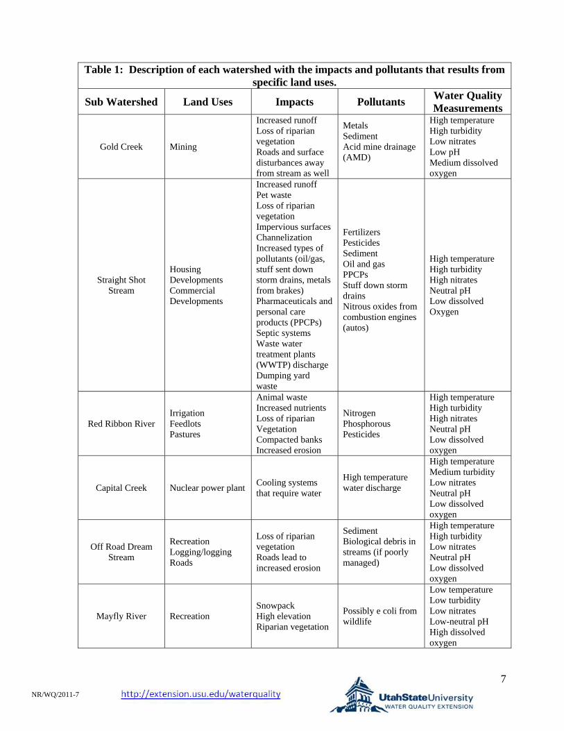
7 NR/WQ/2011-7
Table 1: Description of each watershed with the impacts and pollutants that results from specific land uses.
Sub Watershed Land Uses Impacts Pollutants Water Quality Measurements
Gold Creek Mining
Increased runoff Loss of riparian vegetation Roads and surface disturbances away from stream as well
Metals Sediment Acid mine drainage (AMD)
High temperature High turbidity Low nitrates Low pH Medium dissolved oxygen
Straight Shot Stream
Housing Developments Commercial Developments
Increased runoff Pet waste Loss of riparian vegetation Impervious surfaces Channelization Increased types of pollutants (oil/gas, stuff sent down storm drains, metals from brakes) Pharmaceuticals and personal care products (PPCPs) Septic systems Waste water treatment plants (WWTP) discharge Dumping yard waste
Fertilizers Pesticides Sediment Oil and gas PPCPs Stuff down storm drains Nitrous oxides from combustion engines (autos)
High temperature High turbidity High nitrates Neutral pH Low dissolved Oxygen
Red Ribbon River Irrigation Feedlots Pastures
Animal waste Increased nutrients Loss of riparian Vegetation Compacted banks Increased erosion
Nitrogen Phosphorous Pesticides
High temperature High turbidity High nitrates Neutral pH Low dissolved oxygen
Capital Creek Nuclear power plant Cooling systems that require water
High temperature water discharge
High temperature Medium turbidity Low nitrates Neutral pH Low dissolved oxygen
Off Road Dream Stream
Recreation Logging/logging Roads
Loss of riparian vegetation Roads lead to increased erosion
Sediment Biological debris in streams (if poorly managed)
High temperature High turbidity Low nitrates Neutral pH Low dissolved oxygen
Mayfly River Recreation Snowpack High elevation Riparian vegetation
Possibly e coli from wildlife
Low temperature Low turbidity Low nitrates Low-neutral pH High dissolved oxygen

8
Interpretation of results for each watershed
Gold Creek
High Temperature Due to loss of riparian vegetation, which was cleared for easier access to the desired
metals, more sun reached the water surface. High Turbidity
Caused by increased sediment from the excavation and unstable banks. Low Nitrates (natural)
No impact. Low pH
Increased acidity from acid mine drainage (AMD). Medium Dissolved Oxygen (natural)
No impact. Straight Shot Stream
High Temperature Loss of riparian vegetation, which was cleared for easier access to the river, more sun
reached the water surface. High Turbidity
Increased sediment from excavation and unstable banks. High Nitrates
Increased in nutrients from fertilizers. Also combustion engines (autos) convert nitrogen gas to nitrous oxides, which come down as acid rain and result in increased nitrogen concentrations.
Neutral pH (natural) No impact.
Low Dissolved Oxygen (natural) Water with higher temperatures can hold less dissolved oxygen.
Red Ribbon River
High Temperature Loss of riparian vegetation from overgrazing allowed more sun to reach the water
surface. High Turbidity
Steepened and unstable banks increased sediment input. High Nitrates
Increase in animal waste. Neutral pH(natural)
No impact. Low Dissolved Oxygen
Water with higher temperatures can hold less dissolved oxygen.

9 NR/WQ/2011-7
Capital Creek
High Temperature Discharge of higher temperature water from power plant.
Medium Turbidity (natural) No impact.
Low Nitrates (natural) No impact.
Low pH(natural) No impact.
Low Dissolved Oxygen The high temperature water discharged from the power plant increases creek
temperature. Water with higher temperatures can hold less dissolved oxygen. Off Road Dream Stream
High Temperature Due to loss of riparian vegetation, which was cleared for roads and logging, more sun
reached the water surface. High Turbidity
Caused by increased sediment from the excavation and unstable banks. Low Nitrates (natural)
No impact. Neutral pH(natural)
No impact. Low Dissolved Oxygen
Water with higher temperatures can hold less oxygen. Mayfly River
Low Temperature (natural) No impact because high elevation.
Low Turbidity(natural) No impact.
Low Nitrates (natural) No impact.
Low-neutral pH(natural) No impact because high elevation river fed by rain is naturally acidic.
High Dissolved Oxygen (natural) No impact.

10

11 NR/WQ/2011-7

12

13 NR/WQ/2011-7

14

15 NR/WQ/2011-7

16
Discussion Questions: How do other mining practices impact our watersheds?
Oil and Gas Exploration Geologic formations with large quantities of oil and gas often have low permeability. Hydraulic Fracturing (also known as fracking) is a technique used to release oil and gas from rock pores by creating fractures running from the trapped substances to the production well. Water, proppants (sand or ceramic beads), and chemicals are typically mixed and pumped into the formation in order to make these fractures. Fracturing fluid is then pumped out and put into surface pits or tanks. However, due to human and mechanical errors (e.g., cracked cement tubing) some of this mixture can instead remain underground and contaminate groundwater. The chemicals in these fracturing fluids can be toxic to humans and wildlife. Sometimes these fracturing fluids are injected directly into underground sources of drinking water.
How do other industrial practices impact our watersheds? Wastewater Treatment Plants Wastewater treatment is a process to remove pollutants and improve and purify water so that it is fit for reuse or to be discharged back into the environment. However, the discharge of untreated or inadequately treated water from wastewater treatment plants can cause outbreaks of disease or other health problems for aquatic and human life. Contaminants can come from various industries including the production of pharmaceuticals, food and beverage, pulp and paper, and more. Permit requirements for wastewater treatment facilities only include some nutrients, temperature, and oxygen content. Pharmaceuticals, hormones, and other organic material are contaminants found in water that do not have permit requirements. However, the concentrations of these unregulated materials are small (usually measured in parts per billion or trillion).
What is clean water?
There is no single definition of clean water. The Clean Water Act defines clean water according to how we use it. Some beneficial uses for clean water include drinking water, agriculture, recreation, aquatic wildlife, and aesthetics. Each state designates beneficial uses. In Idaho industry is considered a beneficial use, but in Utah there is no such designation. Each designated use has a different set of water quality standards. The standard for aquatic life is usually the most rigorous. Aquatic organisms are constantly immersed in water and exposed to any pollutants it might contain. Therefore the standards for this beneficial use is actually lower than drinking water standards.
What is the difference between point source and non-point source pollution?
Point source pollution is from a single source that can easily be identified or pinpointed as the source of pollution. An example is an industrial factory, a feed lot or a wastewater treatment plant. Non-point source pollution comes from a large area of

17 NR/WQ/2011-7
land where they are many contributors to the same pollution. An example is urban runoff, agricultural fields, housing developments.
Point source pollution is easy to regulate because it is easy to identify where the pollution is coming from and where it is entering the rivers or streams. It is also easy to measure the amount of pollution entering a water body from a point source. Non-point source on the other hand is very difficult to regulate.
Additional Resources:
USU water Quality Extension - http://extension.usu.edu/waterquality
Division of Water Resources Water Education - http://www.watereducation.utah.gov/
Surf Your Watershed - http://cfpub.epa.gov/surf/locate/index.cfm
Environment Canada - http://www.ec.gc.ca/water/en/nature/prop/e_cycle.htm

18
Water Quality Sampling Data Sheet
Temperature Turbidity Nitrate pH Dissolved Oxygen
Sample A 18oC NTUs mg/liter 7.5 mg/liter
Sample B 21oC NTUs mg/liter 6 mg/liter
Sample C 22oC NTUs mg/liter 5.5 mg/liter
Sample D 25oC NTUs mg/liter 5.5 mg/liter
Sample E 21oC NTUs mg/liter 7.0 mg/liter
Sample F 16oC NTUs mg/liter 8.5 mg/liter

19 NR/WQ/2011-7
Utah’s Criteria Temperature The maximum temperature for warmwater fisheries is 27 C (81 F). The maximum temperature for coldwater fisheries is 20 C (68 F). Turbidity The maximum increase over natural levels in most rivers is 10 NTUs. Nitrates The maximum concentration for drinking water is 10 mg/liter. For rivers a concentration of 4 or above indicates a possible pollution problem. pH The allowable range for most waters in Utah is 6.5 to 9.0. Dissolved Oxygen The minimum concentration for warmwater fisheries is 5.5 mg/liter. The minimum concentration for coldwater fisheries is 6.5 mg/liter.

20
Turbidity Conversion Chart Distance from the bottom of the tube NTUs
< 6 >240 6 to 7 240 7 to 8 185 8 to 9 150 9 to 10 120
10 to 12 100 12 to 14 90 14 to 16 65 16 to 19 50 19 to 21 40 21 to 24 35 24 to 26 30 26 to 29 27 29 to 31 24 31 to 34 21 34 to 36 19 36 to 39 17 39 to 41 15 41 to 44 14 44 to 46 13 46 to 49 12 49 to 51 11 51 to 54 10 54 to 58 9 58 to 60 8
Over the top 6

21 NR/WQ/2011-7
Core Curriculum Alignments 8th Grade Standard 2, Objective 3: Analyze human influence on the capacity of an environment to sustain living things.
a. Describe specific examples of how humans have changed the capacity of an environment to support specific life forms (e.g., people create wetlands and nesting boxes that increase the number and range of wood ducks, acid rain damages amphibian eggs and reduces population of frogs, clear cutting forests affects squirrel populations, suburban sprawl reduces mule deer winter range thus decreasing numbers of deer).
9-12 Biological
Standard 1, Objective 2: Explain relationships between matter cycles and organisms.
a. Use diagrams to trace the movement of matter through a cycle (i.e., carbon, oxygen, nitrogen, water) in a variety of biological communities and ecosystems.
d. Evaluate the impact of personal choices in relation to the cycling of matter within an ecosystem (e.g., impact of automobiles on the carbon cycle, impact on landfills of processed and packaged foods).
9-12 Chemistry Standard 6, Objective 3: Differentiate between acids and bases in terms of hydrogen ion concentration.
a. Relate hydrogen ion concentration to pH values and to the terms acidic, basic or neutral.
b. Using an indicator, measure the pH of common household solutions and standard laboratory solutions, and identify them as acids or bases.
c. Determine the concentration of an acid or a base using a simple acid-base titration. d. Research and report on the uses of acids and bases in industry, agriculture, medicine,
mining, manufacturing, or construction. e. Evaluate mechanisms by which pollutants modify the pH of various environments (e.g.,
aquatic, atmospheric, soil).
9-12 Earth Systems Standard 2, Objective 2: Analyze how ecosystems differ from each other due to abiotic and biotic factors.
a. Observe and list abiotic factors (e.g., temperature, water, nutrients, sunlight, pH, topography) in specific ecosystems.

22
c. Predict how an ecosystem will change as a result of major changes in an abiotic and/or biotic factor.
e. Analyze interactions within an ecosystem (e.g., water temperature and fish species, weathering and water pH).
Standard 4, Objective 1: Explain the water cycle in terms of its reservoirs, the movement between reservoirs, and the energy to move water. Evaluate the importance of freshwater to the biosphere.
d. Make inferences about the quality and/or quantity of freshwater, using data collected from local water systems.