
WASL Progress and Experiences
26
WASL Progress and Experiences 3 February 2014 Michael Balinga, Joachim Binam, Rabdo Abdoulaye and Jerome Tondoh
-
Upload
forest-trees-sentinel-landscapes -
Category
Science
-
view
103 -
download
0
Transcript of WASL Progress and Experiences

WASL Progress and Experiences
3 February 2014
Michael Balinga, Joachim Binam, Rabdo Abdoulaye and Jerome Tondoh

SITE SELECTION
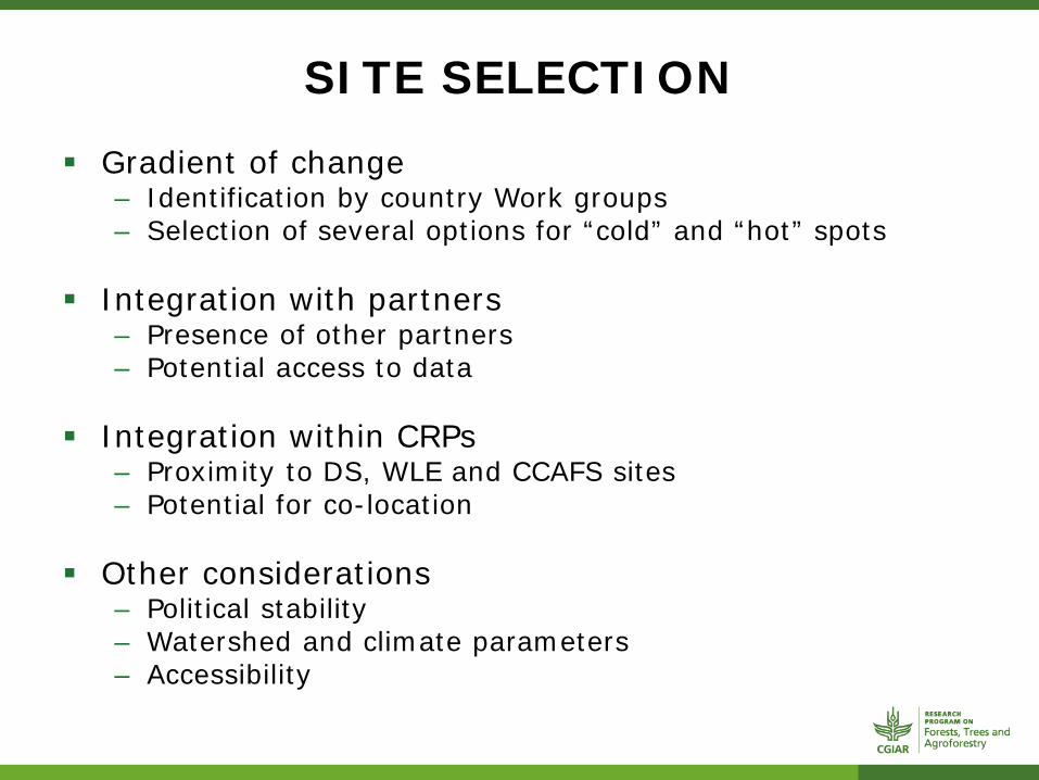
SITE SELECTION
Gradient of change – Identification by country Work groups – Selection of several options for “cold” and “hot” spots
Integration with partners – Presence of other partners – Potential access to data
Integration within CRPs – Proximity to DS, WLE and CCAFS sites – Potential for co-location
Other considerations – Political stability – Watershed and climate parameters – Accessibility

SITE SELECTION

SITE SELECTION
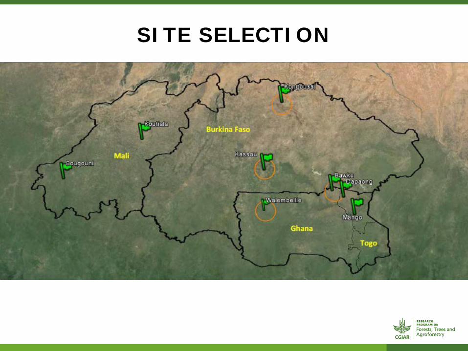
SITE SELECTION
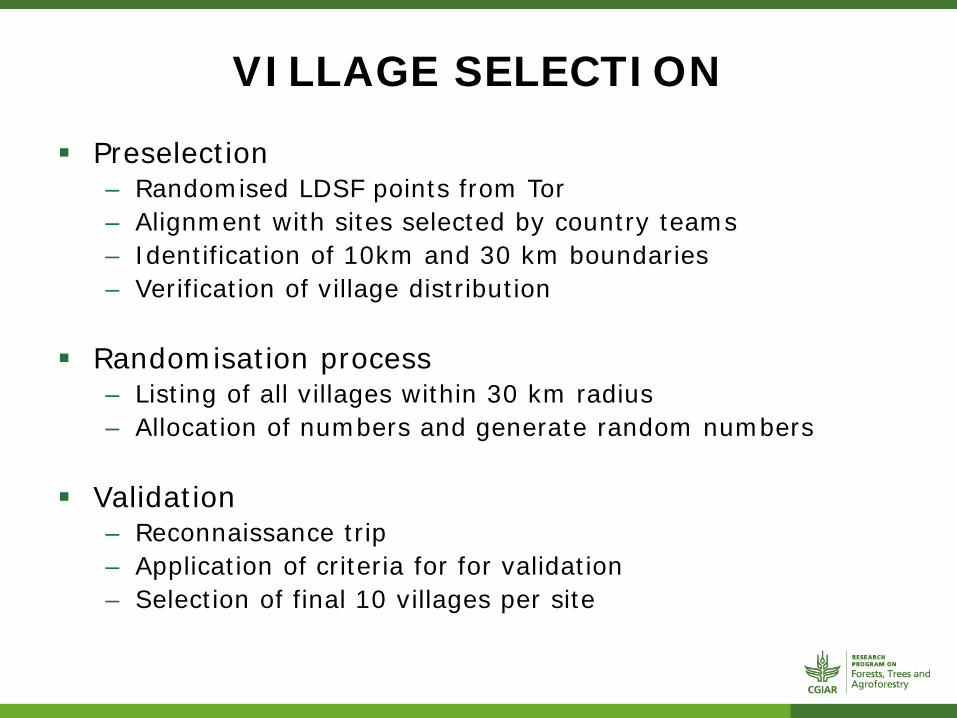
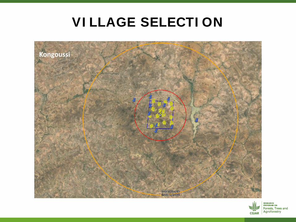
VILLAGE SELECTION
Preselection – Randomised LDSF points from Tor – Alignment with sites selected by country teams – Identification of 10km and 30 km boundaries – Verification of village distribution
Randomisation process – Listing of all villages within 30 km radius – Allocation of numbers and generate random numbers
Validation – Reconnaissance trip – Application of criteria for for validation – Selection of final 10 villages per site
VILLAGE SELECTION
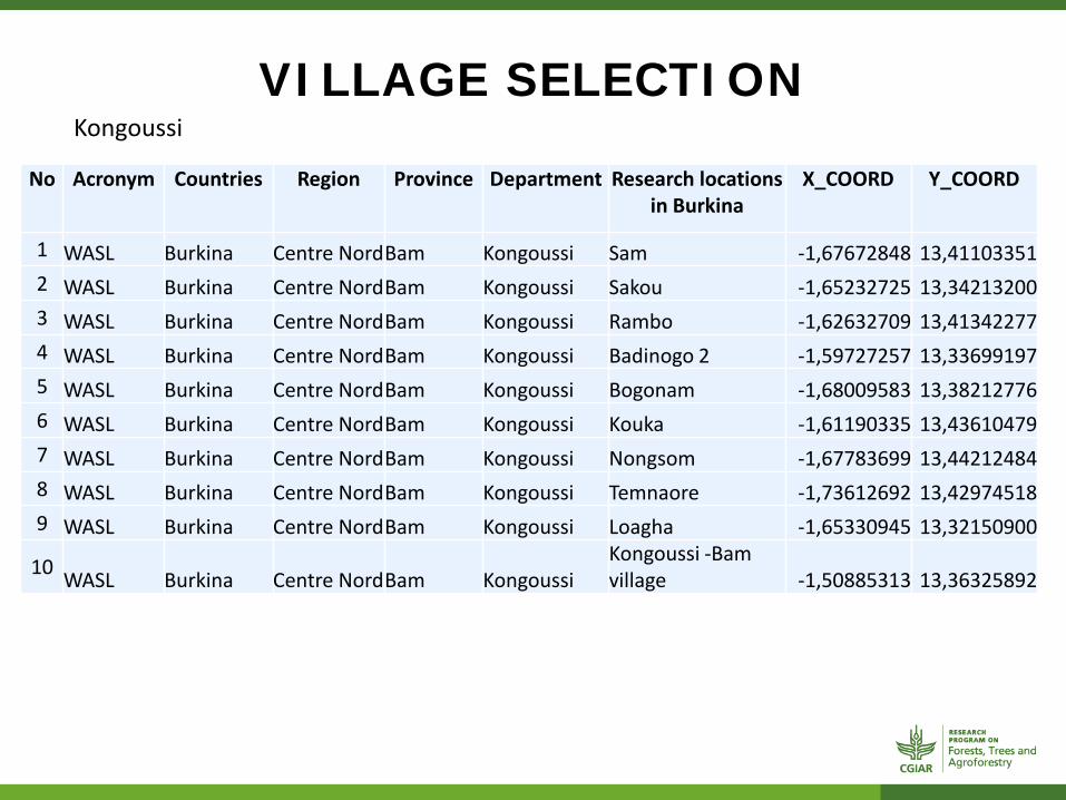
Kongoussi
VILLAGE SELECTION
No Acronym Countries Region Province Department Research locations in Burkina
X_COORD Y_COORD
1 WASL Burkina Centre Nord Bam Kongoussi Sam -1,67672848 13,41103351 2 WASL Burkina Centre Nord Bam Kongoussi Sakou -1,65232725 13,34213200 3 WASL Burkina Centre Nord Bam Kongoussi Rambo -1,62632709 13,41342277 4 WASL Burkina Centre Nord Bam Kongoussi Badinogo 2 -1,59727257 13,33699197 5 WASL Burkina Centre Nord Bam Kongoussi Bogonam -1,68009583 13,38212776 6 WASL Burkina Centre Nord Bam Kongoussi Kouka -1,61190335 13,43610479 7 WASL Burkina Centre Nord Bam Kongoussi Nongsom -1,67783699 13,44212484 8 WASL Burkina Centre Nord Bam Kongoussi Temnaore -1,73612692 13,42974518 9 WASL Burkina Centre Nord Bam Kongoussi Loagha -1,65330945 13,32150900
10 WASL Burkina Centre Nord Bam Kongoussi Kongoussi -Bam village -1,50885313 13,36325892
Kongoussi

VILLAGE SELECTION Kongoussi
Low forest cover Scattered settlements Villages divided into « Quartiers » made of several
compounds/concessions belonging to a big family group. Moose considered natives and Peuhls migrants Main crops: maize, millet, sorghum Trees are used for food and revenue (NTFPs), but also
construction and furniture, as well as for water and soil conservation

VILLAGE SELECTION
Village Demo 2006
Demo 2013 HH 2006 HH est. 2013 No. of
compounds
Kouka 858 1062 137 151 57 Nongsom 0 0 0 100 15 Bogonam 2172 2689 348 100 15 Loaga 1789 2215 320 263 39 Sam 845 1046 120 133 60 Rambo Wattinoma 1158 1434 170 191 40 Sakou 1419 1757 229 320 64 Temnaoré 2606 3227 377 377 15 Badinogo 2 546 676 100 92 24 Bam village 3289 4073 622 444 17

VILLAGE SELECTION
Cassou
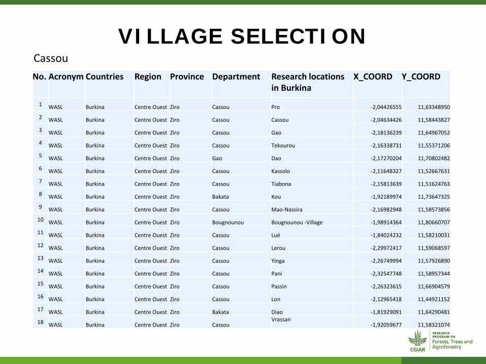
VILLAGE SELECTION Cassou No. Acronym Countries Region Province Department Research locations
in Burkina X_COORD Y_COORD
1 WASL Burkina Centre Ouest Ziro Cassou Pro -2,04426555 11,63348950
2 WASL Burkina Centre Ouest Ziro Cassou Cassou -2,04634426 11,58443827
3 WASL Burkina Centre Ouest Ziro Cassou Gao -2,18136239 11,64967052
4 WASL Burkina Centre Ouest Ziro Cassou Tekourou -2,16338731 11,55371206
5 WASL Burkina Centre Ouest Ziro Gao Dao -2,17270204 11,70802482
6 WASL Burkina Centre Ouest Ziro Cassou Kassolo -2,11648327 11,52667631
7 WASL Burkina Centre Ouest Ziro Cassou Tiabona -2,15813639 11,51624763
8 WASL Burkina Centre Ouest Ziro Bakata Kou -1,92189974 11,73647325
9 WASL Burkina Centre Ouest Ziro Cassou Mao-Nassira -2,16982948 11,58573856
10 WASL Burkina Centre Ouest Ziro Bougnounou Bougnounou -Village -1,98914364 11,80660707
11 WASL Burkina Centre Ouest Ziro Cassou Lué -1,84024232 11,58210031
12 WASL Burkina Centre Ouest Ziro Cassou Lerou -2,29972417 11,59068597
13 WASL Burkina Centre Ouest Ziro Cassou Yinga -2,26749994 11,57926890
14 WASL Burkina Centre Ouest Ziro Cassou Pani -2,32547748 11,58957344
15 WASL Burkina Centre Ouest Ziro Cassou Passin -2,26323615 11,66904579
16 WASL Burkina Centre Ouest Ziro Cassou Lon -2,12965418 11,44921152
17 WASL Burkina Centre Ouest Ziro Bakata Diao -1,81929091 11,64290481
18 WASL Burkina Centre Ouest Ziro Cassou Vrassan
-1,92059677 11,58321074

VILLAGE SELECTION Cassou
Village Demo 2006
Demo 2013 HH 2006 HH est.
2013 No. of
compounds Pro 794 983 130 75 8
Bougnounou 4905 6074 689 1850 450
Kassolo-Tiabona 3125 3870 424 / / Dao 1982 2454 258 224 104 Cassou 3867 4788 662 999 57
Mao-Nassira 4617 5717 630 912 228 Tekourou 2439 3020 344 315 228 Vrassan 1011 1252 155 133 45 Gao 2389 2958 344 385 65 kou 1923 2381 269 1200 413
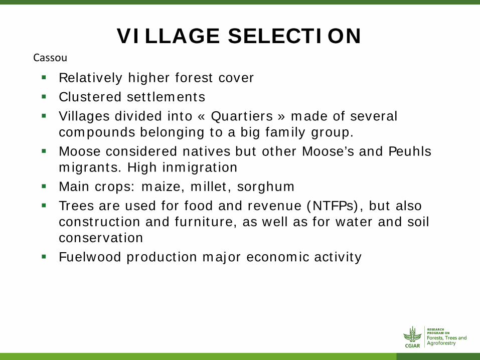
VILLAGE SELECTION Cassou
Relatively higher forest cover Clustered settlements Villages divided into « Quartiers » made of several
compounds belonging to a big family group. Moose considered natives but other Moose’s and Peuhls
migrants. High inmigration Main crops: maize, millet, sorghum Trees are used for food and revenue (NTFPs), but also
construction and furniture, as well as for water and soil conservation
Fuelwood production major economic activity
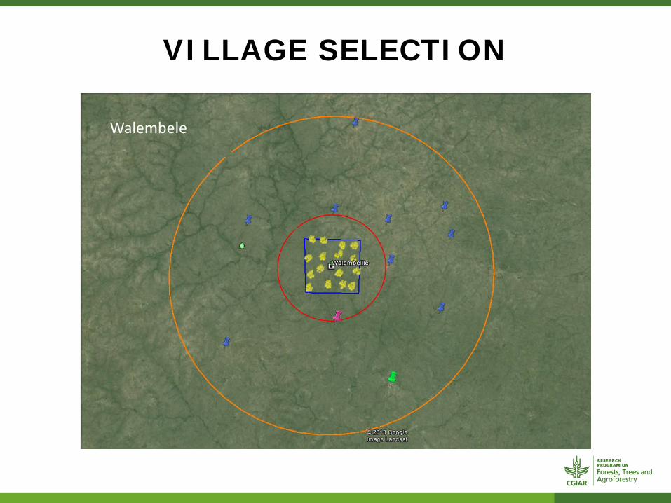
VILLAGE SELECTION
Walembele

VILLAGE SELECTION
Bawku
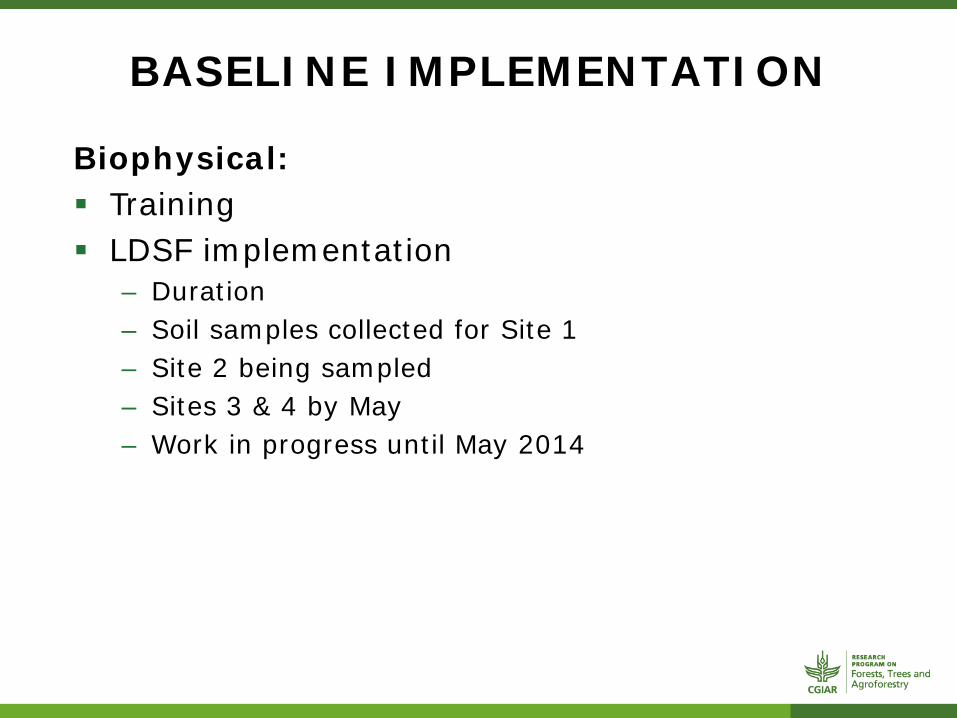
BASELINE IMPLEMENTATION
Biophysical: Training LDSF implementation
– Duration – Soil samples collected for Site 1 – Site 2 being sampled – Sites 3 & 4 by May – Work in progress until May 2014

BASELINE IMPLEMENTATION
Socio Economic: Training Focus Group Discussions
– Settlement form – Association form – Product form – Forest form – Stages of Poverty (Krishna et al. 2006)
HH survey – Questionaires
BASELINE IMPLEMENTATION
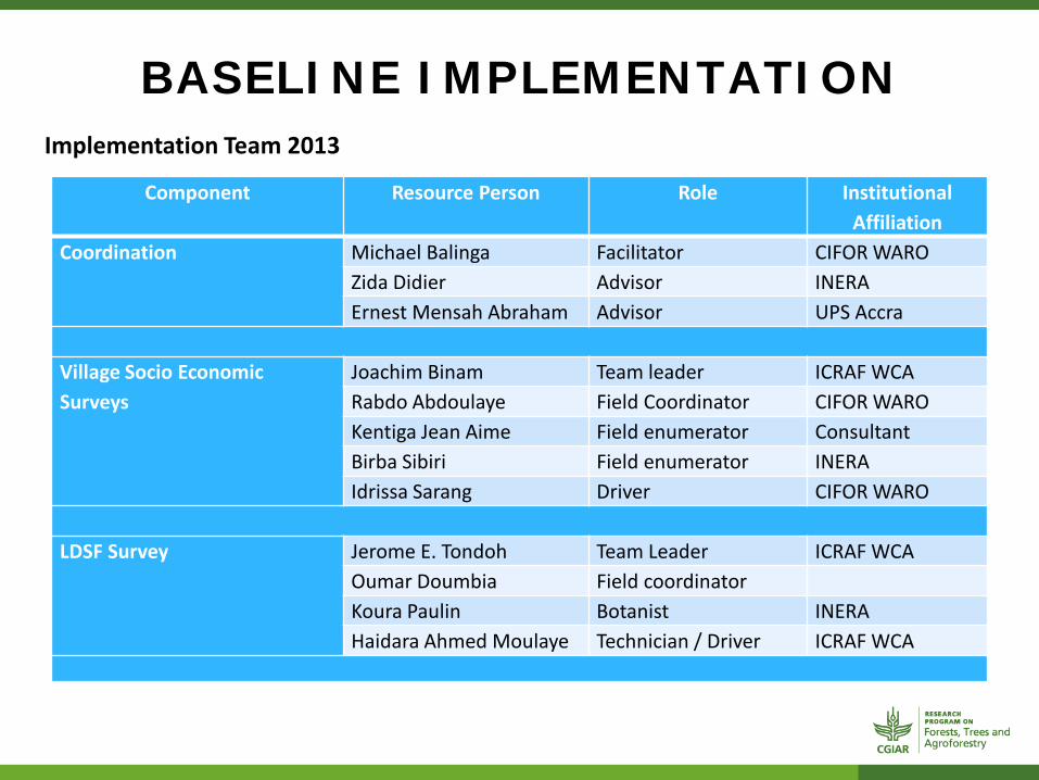
Component Resource Person Role Institutional Affiliation
Coordination Michael Balinga Facilitator CIFOR WARO Zida Didier Advisor INERA Ernest Mensah Abraham Advisor UPS Accra
Village Socio Economic Surveys
Joachim Binam Team leader ICRAF WCA Rabdo Abdoulaye Field Coordinator CIFOR WARO Kentiga Jean Aime Field enumerator Consultant Birba Sibiri Field enumerator INERA Idrissa Sarang Driver CIFOR WARO
LDSF Survey Jerome E. Tondoh Team Leader ICRAF WCA
Oumar Doumbia Field coordinator Koura Paulin Botanist INERA Haidara Ahmed Moulaye Technician / Driver ICRAF WCA
Implementation Team 2013
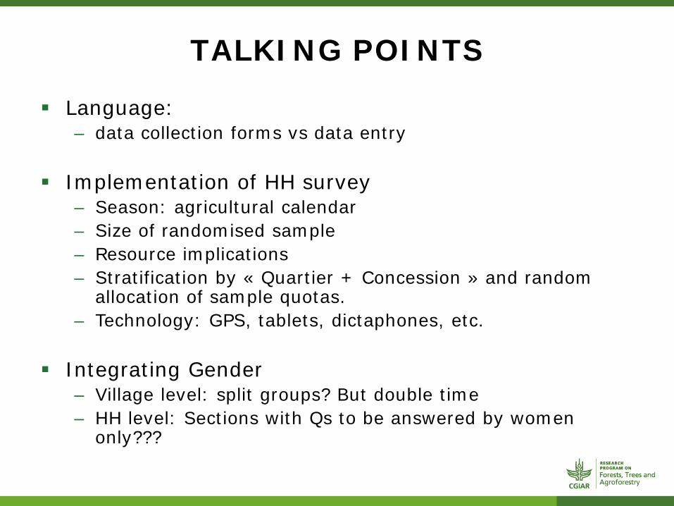
TALKING POINTS
Language: – data collection forms vs data entry
Implementation of HH survey – Season: agricultural calendar – Size of randomised sample – Resource implications – Stratification by « Quartier + Concession » and random
allocation of sample quotas. – Technology: GPS, tablets, dictaphones, etc.
Integrating Gender – Village level: split groups? But double time – HH level: Sections with Qs to be answered by women
only???
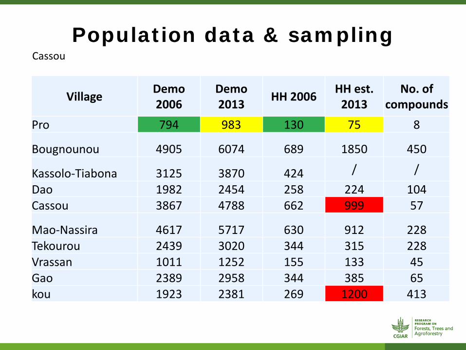
Population data & sampling Cassou
Village Demo 2006
Demo 2013 HH 2006 HH est.
2013 No. of
compounds Pro 794 983 130 75 8
Bougnounou 4905 6074 689 1850 450
Kassolo-Tiabona 3125 3870 424 / / Dao 1982 2454 258 224 104 Cassou 3867 4788 662 999 57
Mao-Nassira 4617 5717 630 912 228 Tekourou 2439 3020 344 315 228 Vrassan 1011 1252 155 133 45 Gao 2389 2958 344 385 65 kou 1923 2381 269 1200 413

TALKING POINTS
Lengthy tools Dwindling interest and dismissive answers Increased time and financial cost
Defining Forests Which Forest (reserve / private / parklands) What boundary for different communities or interests
(mining, agro – bussiness, conservation, migrant) Season Farming season Harvest time Rainy season Difficult to mobilise respondents

TALKING POINTS
Methods Village samples and numbers Increased time and financial cost for « new » methods Accuracy of translated tools
Administration Procedures across institutions
Technology Familiarity with digital tools (tablet + software) Security in the field

TALKING POINTS
Changes to future initiatives – Institutional arrangements: one cost center; similar
logistics procedures where possible (vehicle hire, etc.) – Training of all teams on methods prior to implementation – Data collection: shorter tools/increased resources,
improved timing viz. Farming calendars – Sharing tools, resources and data with other projects to
minimize costs on SL and avoid research fatigue – Others stemming from lessons learnt as we proceed